LOCAL DEVELOPMENT PLAN 2021 - DEVELOPMENT OF ALTERNATIVE STRATEGIC OPTIONS - Caerphilly County ...
←
→
Page content transcription
If your browser does not render page correctly, please read the page content below
SB02
         CAERPHILLY                     COUNTY               BOROUGH

LOCAL DEVELOPMENT PLAN 2021
 DEVELOPMENT OF ALTERNATIVE STRATEGIC OPTIONS

BRIEFING PAPER & QUESTIONNAIRE - JULY 2006
P Mears, Chief Planning Officer, Directorate of the Environment,
Civic Offices, Pontllanfraith, NP12 2YW. ldp@caerphilly.gov.uk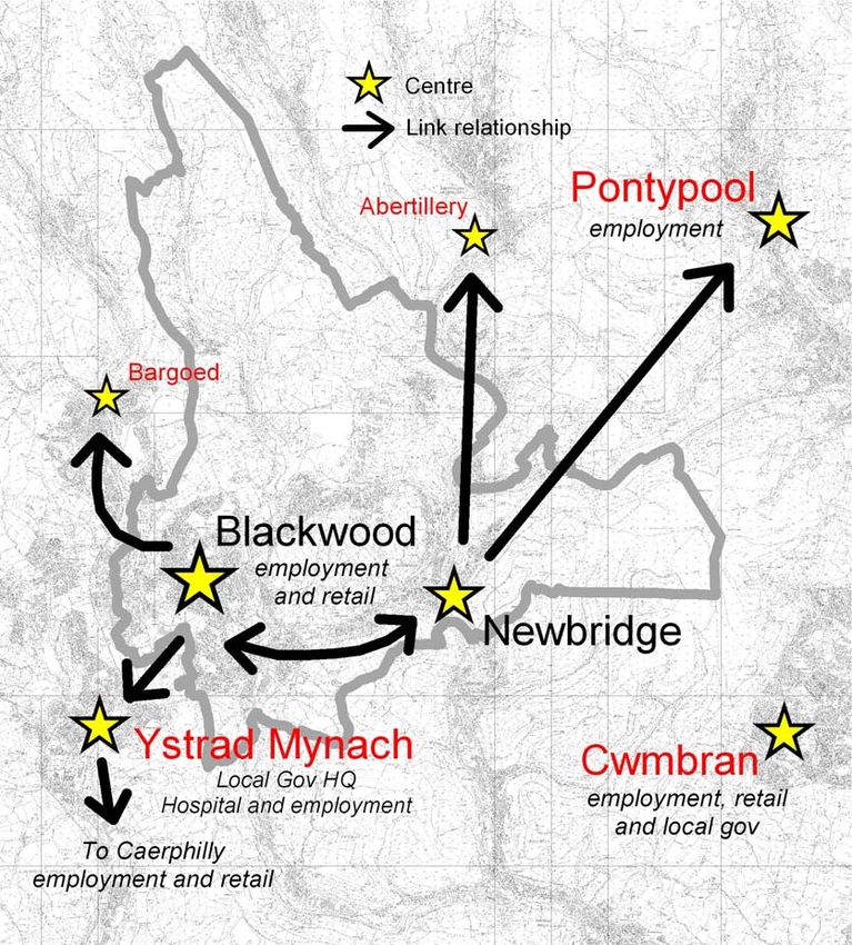
Strategic Options Workshop Paper

                      CONTENTS
                                                            Page

Section 1          Background                               3
Section 2          Land Availability                        4
Section 3          Developing Strategic Options             8
Section 4          Functional Analysis                      15
                   Upper Rhymney Valley                     16
                   Mid Valleys West                         28
                   Mid Valleys East                         36
                   Lower Islwyn                             46
                   Caerphilly Basin                         55

Appendices
Appendix 1   Issues arising out of the Strategic            65
             Environmental Assessment and
             Sustainability Appraisal
Appendix 2   Proposed Scale of Housing                      69
             Development
Appendix 3   Questionnaire                                  73

                             2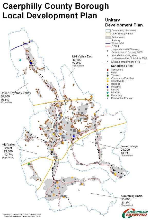
Strategic Options Workshop Paper

SECTION 1: BACKGROUND

1.1 An important feature of the new Local Development Plan
System is the emphasis on identifying and testing realistic
alternative strategic development options. As an integral part of
this process the Council will need to have regard for regional
trends, cross border implications and the role and function of
Caerphilly County Borough within the wider geographical context.

Caerphilly CBC Context

1.2 The LDP will be prepared by a careful analysis of the evidence
base. Developing this evidence base is a continuous process. A
series of information notes are in the process of being produced as
part of plan preparation which monitor the success, or otherwise,
of the existing policies in the Approved UDP. The information
notes will be made available on the Council’s web site in due
course.

1.3 The Scoping Report for the Strategic Environmental
Assessment of the Plan provides a baseline assessment of the key
characteristics of the county borough and highlights key issues that
the development plan will need to address (refer to Appendix 1)

Developing Options
1.4 An important new feature of the LDP is the emphasis on
identifying and testing realistic strategic options that can help the
Council achieve its Vision for the County Borough over the plan
period. In order to develop realistic options a series of stakeholder
workshops are being held in July and August. The discussions
held at these workshop sessions will enable the Council to
determine in consultation, what type of strategy options and what
scale of future housing development would result in the most
sustainable future for Caerphilly County Borough (refer to
Appendix 2)

Having your say
1.5 Appendix 3 comprises a Questionnaire which forms a part of
the public participation exercise that the Council is undertaking to
help inform the development strategy that will underpin the
development plan for the county Borough up to 2021

                                 3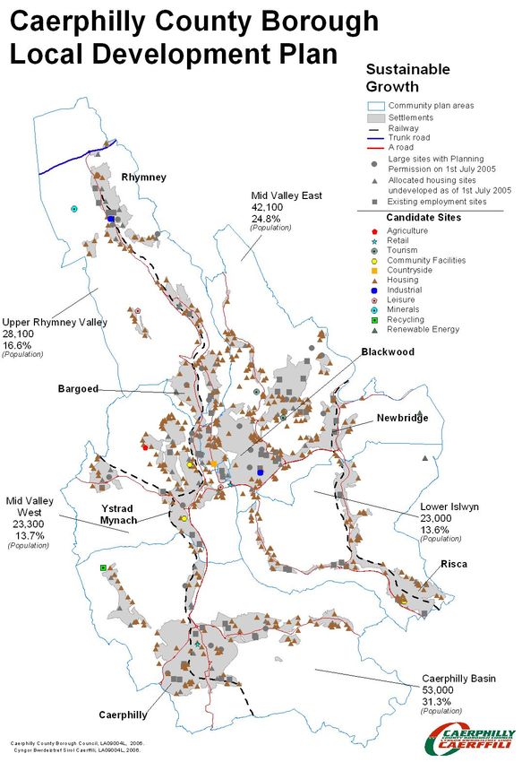
Strategic Options Workshop Paper

SECTION 2 LAND AVAILABILTY
Existing Commitments
2.1 The Council has an Approved Unitary Development Plan,
which allocates land for development to meet the needs of the
County Borough up to 2011. In addition the Council is required to
consider and determine applications for development proposals
submitted by individuals and organisations on a continuing basis.
As a consequence a significant land bank of sites exists and the
spatial distribution of these sites will serve to inform alternative
strategies for development

                                 4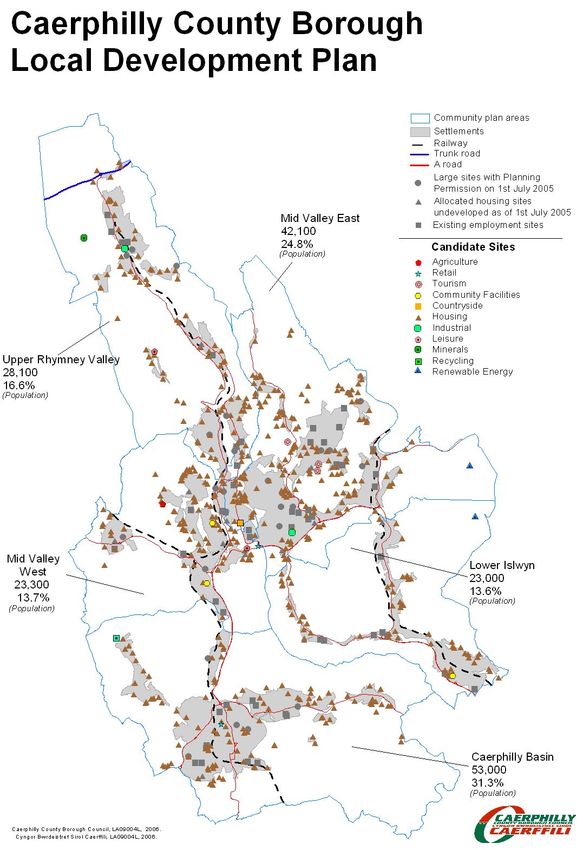
Strategic Options Workshop Paper

Brownfield Opportunities
2.2 There is significant potential within the county borough for
development to take place on brownfield sites within existing
settlements.    Many of these sites would require substantial
remedial work and infrastructure improvements to take place
before development could be permitted.           The inclusion or
otherwise of these sites for development will be determined by the
type of development strategy that the Council in partnership with
our stakeholders pursues through the LDP.

                                5
Strategic Options Workshop Paper

Candidate Sites
2.3 One of the key differences between the old development plan
system and the new system is the need to identify sites with
development potential as an integral part of the evidence base.
Under the previous system it was usual for developers and
landowners to submit representations in respect of new /
alternative sites during the ‘Deposit Period’ of the plan preparation
process.     The new system discourages this approach and
encourages LPAs to actively seek out sites for early consideration,
in order to give the Council the opportunity to consider alternative
sites when developing strategy options.

                                 6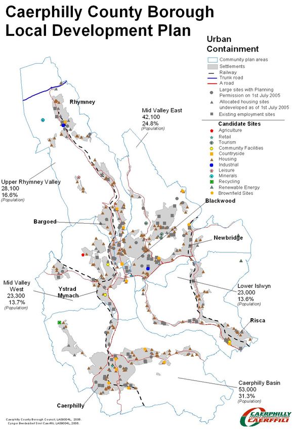
Strategic Options Workshop Paper

2.4 In order to obtain this evidence, earlier this year the Council
invited interested individuals and organisations to put forward
candidate sites for development.
2.5 It should be noted that not all of these sites will be suitable for
development and officers are in the process of assessing them to
determine their suitability or otherwise for various land uses. Once
the assessment is complete a Site Register will be made available
on the web site with baseline data assembled in respect of each of
the sites.

            Candidate Sites Submitted by Community Plan
                               Area

                                                Caerphilly Basin
                                                Lower Islwyn
                                                Mid Valleys East
                                                Mid Valleys West
                                                Upper Rhymney Valley

                                  7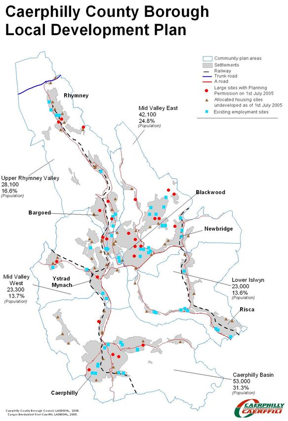
Strategic Options Workshop Paper

SECTION 3 DEVELOPING STRATEGIC OTIONS

Vision for Caerphilly County Borough

3.1 The Council held workshops in April and May 2006 to develop
a Vision Statement for the LDP to guide the development of the
County Borough over the plan period. On the 27th June 2006 the
Council approved the following Draft Vision Statement for the early
stages of plan preparation:

    The Development Strategy for Caerphilly County Borough
    will ensure that the needs of all the county borough’s
    residents and visitors are met and the regeneration of our
    towns, villages and employment centres and the
    surrounding countryside is delivered in a well-balanced
    and sustainable manner

Strategic Options
3.2 Outlined below are three Strategic Options that emerge from
work undertaken to date. In order to aid discussion and to provide
a useful indication of what each of the options could mean in terms
of actual development on the ground a Map is provided for each
option. The Map indicates the spatial distribution of:
   • the existing land bank of housing and employment sites;
   • known brownfield opportunities where they are applicable to
     the strategy; and
   • candidate sites that could potentially contribute to the
     strategy.

Note: The community plan boundary of the Upper Rhymney
Valley (URV) Area has been amended to coincide with the
Heads of the Valleys boundary. In this respect for the
purpose of this analysis Bargoed is included in the URV and
not in Mid Valleys West.

                                 8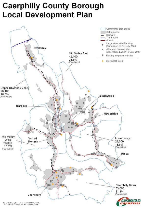
Strategic Options Workshop Paper

OPTION A:         CONTINUATION            OF     UDP       DEVELOPMENT
STRATEGY
a)    Consolidate development in the south of the county borough within
      existing settlements
b)    Allow for the redevelopment of large brownfield sites in the south for
      mixed use development
c)    Development to provide necessary infrastructure improvements
d)    Continue to promote growth in the Mid Valleys Corridor
e)    Release of greenfield sites in the Mid Valleys Corridor to allow for
      additional growth
f)    Allow for development opportunities in the North and in the Aber Valley
g)    Continue previous growth pattern
Figure 2a: Chart to indicate the Candidate sites in each Community Plan
Area that could contribute to the continuation of the UDP Strategy.

                                    UDP

                                                   Caerphilly Basin
                                                   Lower Islwyn
                                                   Mid Valleys East
                                                   Mid Valleys West
                                                   Upper Rhymney Valley

Figure 2b:Chart to indicate the Candidate sites, Existing Commitments
and Brownfield Opportunities in each Community Plan Area that could
contribute to the continuation of the UDP Strategy.

              UDP - Candidate sites and existing commitments

                                                   Caerphilly Basin
                                                   Lower Islwyn
                                                   Mid Valleys East
                                                   Mid Valleys West
                                                   Upper Rhymney Valley

                                     9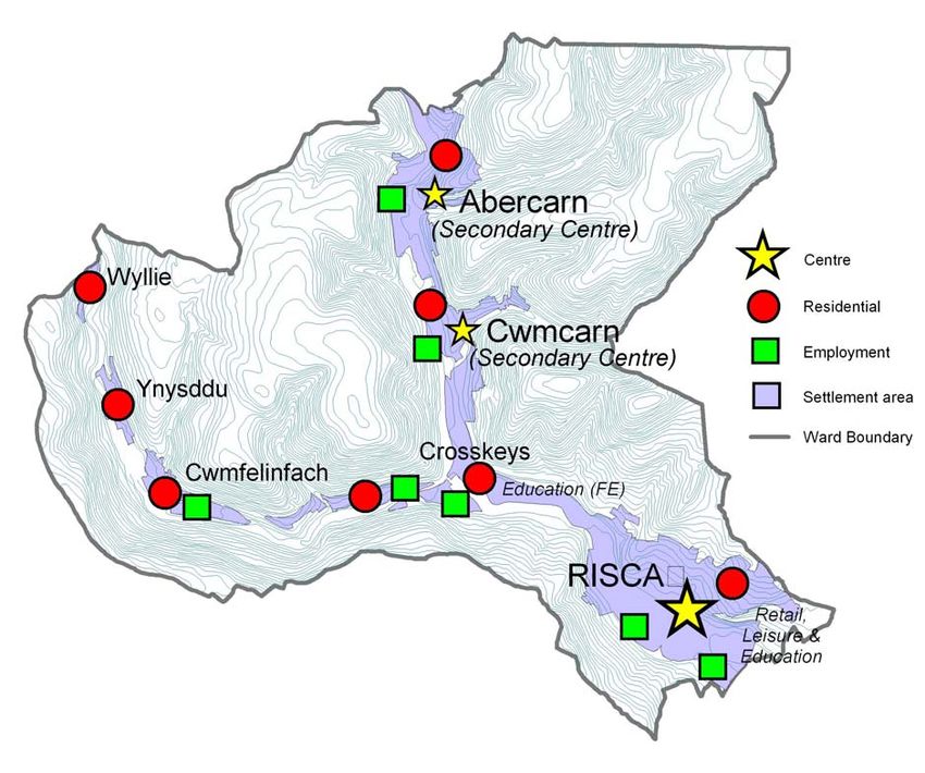
Strategic Options Workshop Paper

10
Strategic Options Workshop Paper

OPTION B: URBAN CONTAINMENT STRATEGY
a)    Exploit brownfield opportunities
b)    Allow for growth in areas where brownfield sites are available
c)    Reduce impact of development on the countryside.
d)    Reduce the need to find new sites for development to accommodate
      future growth.
e)    Sustain existing service provision.
f)    Development to provide necessary infrastructure improvements

Figure 1a: Chart to indicate the Candidate sites in each Community Plan
Area that could contribute to an Urban Containment Strategy.

                             Urban Containment

                                                  Caerphilly Basin
                                                  Lower Islwyn
                                                  Mid Valleys East
                                                  Mid Valleys West
                                                  Upper Rhymney Valley

Figure 1b:Chart to indicate the Candidate sites, Existing Commitments
and Brownfield Opportunities in each Community Plan Area that could
contribute to an Urban Containment Strategy.

                  Urban Containment - Candidate sites and
                          existing commitments

                                                   Caerphilly Basin
                                                   Lower Islwyn
                                                   Mid Valleys East
                                                   Mid Valleys West
                                                   Upper Rhymney Valley

                                      11
Strategic Options Workshop Paper 12
Strategic Options Workshop Paper

OPTION C: SUSTAINABLE GROWTH STRATEGY
a)    Emphasis on key locations near transport routes
b)    Target new development to support threatened services
c)    Expanded settlements
d)    Release of greenfield sites to bolster declining settlements
e)    Potential impact on the countryside
f)    Development to provide necessary infrastructure improvements
g)    Proactively targeting growth to the Mid Valley and Upper Valley Areas
h)    Prevent over heating in the Caerphilly Basin
i)    Development targeted to reflect the role and function of individual
      settlements
Figure 3a: Chart to indicate the Candidate sites in each Community Plan
Area that could contribute to an Urban Containment Strategy.

                             Sustainable Growth

                                                     Caerphilly Basin
                                                     Lower Islwyn
                                                     Mid Valleys East
                                                     Mid Valleys West
                                                     Upper Rhymney Valley

Figure 3b:Chart to indicate the Candidate sites, Existing Commitments
and Brownfield Opportunities in each Community Plan Area that could
contribute to an Sustainable Growth Strategy.

                  Sustainable Growth - Candidate Sites and
                           existing commitments

                                                  Caerphilly Basin
                                                  Lower Islwyn
                                                  Mid Valleys East
                                                  Mid Valleys West
                                                  Upper Rhymney Valley

                                      13
Strategic Options Workshop Paper 14
Strategic Options Workshop Paper

SECTION 4 FUNCTIONAL ANALYSIS                    OF    CAERPHILLY
COUNTY BOROUGH COUNCIL
4.1 As an integral part of plan preparation the Council is required
to devise a settlement strategy for the County Borough. In order to
facilitate this work the Planning Division has undertaken a
functional analysis of the five Community Plan Areas. namely, the:

  1.   Upper Rhymney Valley – incorporating Bargoed
  2.   Mid Valleys West
  3.   Mid Valleys East
  4.   Lower Sirhowy Valley and
  5.   Caerphilly Basin

The following section provides this analysis.

                                 15
Strategic Options Workshop Paper
4a Upper Rhymney Valley (incorporating Bargoed)
1. Overview
1.1 The Upper Rhymney Valley had a population of 28,111 in
2001 – a decrease of 8.2% since 1991. It comprises a cluster of
relatively small former mining settlements along the line of the
River Rhymney and its tributary, the Nant Bargod Rhymney. The
Valley sides are generally very steep but broaden out at the Heads
of the Valleys into a rather bleak plateau. The area is among the
most deprived in Europe – all nine wards in the district are
Community First wards.
2. Main Settlements – Roles & Functions 2006
2.1 Hub; BARGOED is the hub of this district. It is the largest
town in the district with a population, including the suburb of
Gilfach, of 8,300. It contains the only significant shopping centre
with over 100 commercial units, although no major supermarket, a
comprehensive school and swimming pool and a range of minor
urban services.
16Strategic Options Workshop Paper
2.2 Secondary Centre; RHYMNEY is the second largest town
with a population of around 5,500. Its comprehensive school,
further education college, community hospital and discount
supermarket give it the potential to be a secondary centre for the
villages in the northern part of the district.
2.3 Residential areas; NEW TREDEGAR (itself a cluster of five
distinct settlements) ABERBARGOED, DERI, FOCHRIW,
PONTLOTTYN, ABERTYSSWG and a number of small hamlets
are predominantly residential villages. Some have tourism
potential.
2.4 There are three large industrial estates - Heads of the
Valleys, Capital Valley and Maerdy - located in the vicinity of the
settlements of Rhymney and Pontlottyn (a total of 45.4 Ha of
land). In addition, there is an industrial estate south of
Aberbargoed (18 Ha of land), and a new development of small
workshops in New Tredegar. These industrial sites emphasise the
role of the Upper Rhymney Valley for employment uses, especially
as only 4% of land in this area is currently vacant (Caerphilly
Employment Sites Supply and Market Appraisal Study, 2006).
2.5 NEW TREDEGAR is an exemplar of comprehensive
regeneration. Over the past two years a mutually supporting set of
initiatives, including a new community school, new road, incubator
industrial units, environmental improvements, engineering works to
river retaining structures and a comprehensive safe routes to
school footpath network including two major footbridges, has been
implemented in a £20m + package financed from a number of
sources.
17Strategic Options Workshop Paper
3. External linkages
3.1 South. The A469 is the main road route south to Ystrad
Mynach (location of Caerphilly council offices, Further Education
College, proposed new general hospital, employment sites). The
Rhymney Valley railway line connects Rhymney, Pontlottyn, New
Tredegar, Bargoed and Gilfach to Ystrad Mynach, Caerphilly and
the national and regional centre of Cardiff. There is an hourly train
service from Rhymney to Cardiff, with a more frequent 15 min
service from Bargoed to Cardiff. There are also regular bus links to
Ystrad Mynach.
18Strategic Options Workshop Paper
3.2 North-West. The A465 links the district to employment
opportunities along the A465 corridor and to the Sub-regional
centre of Merthyr Tydfil (shopping and current general hospital).
Merthyr can also be accessed by a minor road from Fochriw. A bus
service operates from Bargoed to Merthyr Tydfil via Rhymney.
3.3 North-East. The upgraded dual carriageway section of the
A465 connects the district to employment opportunities along the
A465 corridor and the historic town of Tredegar with its leisure
centre and swimming pool. A sub standard minor road from
Abertysswg provides an alternative access to Tredegar. There is a
bus route to Tredegar from Bargoed and an hourly bus service
linking Tredegar to Rhymney Station.
3.4 South-East A poor network of minor roads leads to the sub-
regional shopping centre and major employment centres around
Blackwood. There is, however, a regular bus from New Tredegar
and Bargoed to Blackwood.
3.5 There are no direct road or rail links to the North, where the
county borough borders the Brecon Beacons National Park.
4. Tourism potential
4.1 The area has the potential to make a major contribution to the
VALLEYS REGIONAL PARK.
4.2 Landscape; The hillsides are dramatic and magnificent views
are obtained form the minor roads and long distance footpaths
along the ridgeways. Most of the countryside is common land ,
including the extensive and historic landscape of Gelligaer
Common. The northern part of the area contains a number of
small lakes and reservoirs, including Parc Cwm Darran lakes,
Rhaslas pond, Butetown reservoir and Jepsons pond.
4.3 Country Parks; there are two major Country parks at Cwm
Darran (Deri and Fochriw) and Parc Coedtir (Bargoed-
Aberbargoed); Bryn Bach Park lies just across the border in
Blaenau Gwent.
4.4 Cyclepaths; the east-west cyclepath from Merthyr to
Tredegar passes through the historic hamlet of Butetown and
leads to Bryn Bach Park. A north-south cyclepath runs through
19Strategic Options Workshop Paper
Parc Coedtir and up to Abertysswg and another cyclepath
connects Bargoed through Deri to Parc Cwm Darran.
4.5 Heritage; Butetown (Welsh ‘Drenewydd’) is a Nineteenth
century ‘model’ settlement, dating from around 1835. It contains 44
listed buildings. The county borough museum is being constructed
20Strategic Options Workshop Paper
in the former mining village of New Tredegar. Roman and
prehistoric remains are found on Gelligaer Common - a
designated ‘historic landscape’.
4.6 Events; Bargoed is seeking to establish a regular annual fair
in its large urban park at Heolddu. This year the event was entitled
Bargoed Big Bed. The annual British Giant Vegetable
Competition at Abertysswg may have some tourism potential if
marketed imaginatively.
4.7 Accommodation; Bargoed and Rhymney have small hotels
and there is a campsite at Parc Cwm Darran.
5. Analysis
In order for the urban cluster to function effectively the following
issues need to be addressed in this district:
• New shops and commercial businesses need to be
developed in the district’s main centre at Bargoed. Attracting a
major food retail ‘anchor store’ is a fundamental requirement.
• The formal Leisure offer also needs to be developed.
Bargoed’s swimming pool is 30 years old and only available to the
public at weekends and evenings. There is no cinema or theatre or
‘family’ pub/restaurants.
• The further education facilities at the secondary centre of
Rhymney could be expanded further if this were compatible with
developments in further education elsewhere in the Heads of
Valleys sub region.
• Railway services are infrequent and need to be increased,
especially between Rhymney and Bargoed.
• Road links will be improved with the construction of Angel
Way (Bargoed relief road) in 2006-08 but the A469 between New
Tredegar and Pontlottyn is poor and acts as a fundamental
constraint on the proper functioning of the district, deterring
movement between the hub at Bargoed and the settlements to the
north. With the scheduled opening of a new general hospital for
the county borough to the south at Ystrad Mynach, the need for
improvement to this section of the A469 will become even more
acute.
21Strategic Options Workshop Paper
• Road links are also poor between the district and the
developing employment opportunities north of Blackwood,
restricting the ability of the large numbers of unemployed and
economically inactive in this area to access the growing
employment opportunities along the mid valleys corridor.
• The surrounding attractive and accessible countryside
provides a very positive environmental setting and the smaller
settlements could provide desirable residential locations if the
choice of housing they offer were not so limited. Most of the
current housing stock is council rented or 19th century terraced and
there is a need to develop a wider choice of modern housing in
most of the settlements in order to retain and attract people to
bring a halt to the rapid population decline of recent decades.
• The east-west and north-south cyclepaths need to be
connected to each other and to the cyclepath network to the south
in order to form an effective part of the regional network.
22Strategic Options Workshop Paper
• The rather bleak ‘mini-lake district’ in the north of the district,
between Rhymney and Fochriw has been identified for a strategic
landscaping initiative that should greatly enhance the potential of
that part of the district to function as a pleasant residential area
and visitor destination.
The historic hamlet of Butetown is located just off the junction of
the A469 and the improved A465 heads of the Valleys Road. It has
the potential to become the centrepiece of a landscaped ‘gateway’
to the Rhymney Valley from the north.
In order to function as part of the South East Wales integrated city
region, the following issues need to be addressed:
• The district’s potential contribution to the Valleys Regional
Park needs to be fully exploited.
•
• Existing residential areas need to be made more attractive
and new residential sites identified in order to halt net
migration outflow from the heads of the Valleys
• The rail service to Cardiff should be improved and in
particular a greater frequency of service provided,
particularly from Rhymney
• The A469 through this district needs to be substantially
improved to facilitate access to employment facilities and
services in the Mid Valleys corridor.
• Transport links to the Oakdale/Blackwood sub-region need to
be improved to provide access to jobs.
6. Functions of Settlements and Future Opportunities
BARGOED
6.1 As the main town in the area, Bargoed provides a range of
functions and services and its position on the Rhymney Valley
railway link is important in maintaining links to the Upper Rhymney
Valley to the north and Ystrad Mynach, Caerphilly and Cardiff in
the south. However, Bargoed cannot offer the range of goods and
services that Caerphilly or Cardiff can offer and its good rail links
may also result in a loss of local trade due to the relative ease of
accessing larger towns.
23Strategic Options Workshop Paper
6.2 The proposed town centre regeneration scheme, in addition to
the town bypass, Angel Way, has the potential to expand the town
functions and increase the sphere of influence, encouraging
people in the Upper Rhymney Valley who may currently use
Merthyr Tydfil as their primary centre to shop and use services
within the County Borough. Whilst the town is constrained by its
topography, there may be limited opportunities for new residential
and office development, supported by the new transport links,
particularly on the Bargoed plateau.
GILFACH
6.3 Gilfach is a small residential area directly south of Bargoed,
which has coalesced with the town. It has a small number of local
shops on Commercial Street, but is subservient to the role of
Bargoed. There is some limited opportunity for residential
development, although its role is likely to remain as a southern
extension to Bargoed.
ABERBARGOED
6.4 Aberbargoed’s function is as an employment and residential
location, with a range of businesses located on industrial estates to
the south of the settlement. Since the development of the plateau
and removal of the spoil tip, the town has a better relationship with
neighbouring Bargoed but poor road links between the two is a
current constraint, which will be alleviated by the Angel Way
bypass. Aberbargoed has the capacity to accommodate some
additional housing through opportunities created by the road.
6.5 There has been a decline in community facilities in the area
with the closure of Bedwellty School in 2005 and the proposed
closure of Aberbargoed hospital due to the new hospital
development in Ystrad Mynach, so the town’s role as a facility
provider is declining. Better connections between Bargoed and
Aberbargoed, and the improved road network may reduce the
impact of this.
NEW TREDEGAR
6.6 The urban area of New Tredegar comprises five distinct
settlements, namely Tirphil, Brithdir, Elliotstown, Philipstown and
New Tredegar, with each village characterised by terraced housing
constrained by the steep topography. Major regeneration has
24Strategic Options Workshop Paper
occurred in recent years through the development of an innovative
community school, new doctor’s surgery, workshop units and road
bypassing the centre, and it is important that this regeneration
work is continued in order to encourage new residential
development to increase the mix of housing types in the area.
6.7 To date much of the investment has occurred on the Valley
floor with little investment in the steepest locations such as
Philipstown. It will be important to extend investment to these
areas.
DERI AND GROESFAEN
6.8 The village of Deri, and the small hamlet of Groesfaen directly
south of Deri are predominately residential areas located in the
Darran Valley. The settlements are isolated due to the steep
topography and poor road links to the closest major town of
Bargoed, but there has been limited self-build residential
development, which has increased the mix of dwelling types in the
area and could be continued in the future if appropriate sites are
identified. Deri also has an important tourism role due to its
position directly south of Parc Cwm Darran and there is the
potential to expand this role in the future
FOCHRIW
6.9 At the northern end of the Darren Valley, Fochriw is a remote
settlement with poor links to any other settlements in the County
Borough. There is great potential for further development in the
area subject to the LDP Strategy as it does not have the
topographical constraints of other settlements in the Upper
Rhymney Valley, but its isolated position means that there is likely
only to be limited demand for additional development. The area
could expand on its tourism role due to its location north of Parc
Cwm Darran.
6.10 Due to the close proximity to Merthyr Tydfil and the
separation of the village from the Rhymney Valley, there is a
strong relationship to areas outside the County Borough, which is
unlikely to change due to the physical boundaries.
RHYMNEY
6.11 As the northern-most town in the County Borough with close
proximity to the A465, Rhymney has an important role within the
Upper Rhymney Valley. The town has an important educational
25Strategic Options Workshop Paper
role due to the location of Rhymney College, part of Ystrad
Mynach College, offering important training opportunities to the
Upper Rhymney Valley.
6.12 Rhymney also has an important employment function, with
the town providing a large area of employment land across three
sites. Capital Valley and Heads of the Valleys Industrial estates are
car-dependent and therefore limit their relationship to Rhymney
itself, an area characterised by low car ownership. However,
proposals to regenerate the town may provide opportunities for
improve the character of the area and increase connections to
employment opportunities.
6.13 Whilst there have been a number of self-build developments
in the town, Rhymney is characterised by high levels of public
sector housing, and further investments in the mix of housing
would be necessary to increase the role of the centre.
BUTETOWN
6.14 As a conservation area comprising three rows of terraced
housing, the small village of Butetown has little residential
potential, although the Drenewydd museum offers tourism
potential.
PRINCETOWN / LLECHYRD
6.15 The small villages of Llechryd and Princetown to the north of
Rhymney on the A465 function as residential settlements offering a
range of different housing types. Llechryd offers some potential for
additional housing depending on the LDP Strategy due to its flat
plateau location. Due to its location north of the A465 and the fact
that the village is split between Blaenau Gwent and Caerphilly
CBC, Princetown is unconnected from Rhymney and relates more
to the settlement of Tredegar than to Rhymney.
PONTLOTTYN
6.16 Whilst in close proximity to Rhymney, Pontlottyn maintains its
own identity offering several retail units and a train station. It
comprises mostly terraced housing, although larger executive
housing is developing to the north of the village. The village is
constrained by the A469 but has some potential on the western
hillside if there is demand and subject to the strategy.
26Strategic Options Workshop Paper
ABERTYSSWG
6.17 Abertysswg is a linear residential settlement south east of
Rhymney comprising mainly terraced housing. Due to the
topography there is only limited opportunity for further
development, although there is a need for a mix of housing types
in the area. There is a clear relationship between Rhymney and
Abertysswg, with Rhymney providing a number of services for the
area.
27Strategic Options Workshop Paper
4.b MID VALLEYS (WEST) DISTRICT
1. Overview
1.1 Situated around the centre of the Rhymney Valley, the Mid
Valleys West district encompasses a town and several large
villages – all of which have strong associations and in most cases
roots in the mining industry. Altogether the population was 23,300
in 2001 (Census), a small increase on the 1991 figure of 22,000.
Geographically, the district is roughly cross-shaped, with the
relatively steep-sided Rhymney Valley running along a north-south
axis, and an east-west gap rising to plateaux near Nelson (east)
and Maesycwmmer (west). In common with the wider valleys,
development has historically spread in a rather random and
haphazard way along the linear valley bottoms, old railway
corridors or near former coal mines. There are sizeable areas of
reasonably fertile agricultural land rising to upland moors.
2. Main Settlements – Roles & Functions
2.1 Primary centre: Within this district, Ystrad Mynach is the
primary settlement although not the most populous – the total,
including the suburb of Tredomen, being 4,000. Here the main
shopping provision comprises a large supermarket and over 80
other commercial units, a comprehensive school, leisure centre
28Strategic Options Workshop Paper
and a range of minor urban services. It is a main administrative
centre for the county borough as location of Caerphilly council
headquarters and a main police station, together with a Further
Education College and the new general hospital. In addition there
are a number of employment sites.
2.2 Secondary Centre: In terms of the next most multi-functional
settlement in the local hierarchy, Nelson has a smaller
supermarket and range of small shops, with a population of around
4,500. Somewhat separate from the main district towns, it is
closely related to the Treharris, Trelewis, Quaker’s Yard and
Abercynon belt of settlements which lie in neighbouring county
boroughs.
2.3 Residential areas: Hengoed, Cefn Hengoed, Gelligaer,
Penpedairheol, Penybryn and Maesycwmmer villages are
mainly residential. Some have tourism potential, particularly
around nodes of historic buildings and landscapes in the area.
2.4 Industry: Main industrial sites are located south of Ystrad
Mynach at Dyffryn, while another major site lies north of the town
and Penallta Colliery. There are smaller mixed developments lining
the A469 through Tiryberth and A472 at Tredomen; location of
the Innovation and Technology centre.
2.5 Regeneration: Penallta Colliery Redevelopment Scheme is
one of the most exciting regeneration projects in the county
borough, on land reclaimed since the pit’s closure in 1991. Here
historic mine buildings are being restored and partially converted
for other uses. A pioneering new ‘urban village’ is to be built,
incorporating the Cwm Calon housing development, a primary
school, public open space and leisure facilities.
2.6 Nearby the old tips have been landscaped and an attractive
Community Park laid out. This includes the impressive horse
sculpture set into the hillside, and a viewing platform overlooking
the valleys below.
3. External linkages
3.1 North: Much development lies along the area’s main spine
road (A469) which links to Bargoed, Rhymney and the A465
Heads of the Valleys road. Parallel to this runs the A4049 road to
29Strategic Options Workshop Paper
New Tredegar. The Rhymney Valley railway line extends to
Bargoed and Rhymney.
3.2 South: The A469 road is the area’s main route to and from
Cardiff city running via Caerphilly. The Rhymney Valley railway
line also connects Caerphilly and Cardiff providing a vital
commuter artery.
3.3 West: The A472 is a major east-west route which from Ystrad
Mynach continues to Nelson and eventually a junction with the
main A470 Cardiff-Merthyr trunk route just outside the county
borough at Abercynon.
3.4 East: Crossing the Rhymney Valley at Ystrad Mynach, the
A472 is a single strategic link to the Blackwood and Newbridge
conurbations. Whilst it bypasses these as a dual carriageway, that
section within the district remains a single lane highway. It is the
main route from the area to Pontypool and Newport (A467) and
has links to roads serving Ebbw Vale (A4046) and Brynmawr
(A467).
30Strategic Options Workshop Paper
4. Leisure & Tourism potential
4.1 Landscape: Striking geological features such as the bowl
shaped landscape at Ystrad Mynach and rock formations
overlooking the Tredomen-Nelson ‘vale’ can be found in the area.
Whilst there are a number of steep hillsides around with minor
roads and long distance footpaths along the ridgeways, there are
several sections of broader and gentler valley landscapes, much of
which has been developed. A substantial swathe of countryside to
the west of the district forms part of Gelligaer Common.
4.2 Country Parks: Prominently situated above the valley floors,
Penallta Community Park features landmark sculptures and
creative landscaping. Also Gelligaer Common has the potential to
be a major component of the Valleys Regional Park. This long
term project could build upon the existing network of parks in close
proximity, such as the Taff Bargoed Millennium Park between
Treharris and Bedlinog. At Nelson, Wern Crescent Woodland
Park is an attractive facility with similarly high quality landscaping.
The park links into the village centre and nearby sites of nature
conservation importance.
4.3 Cyclepaths: A dedicated east-west cyclepath runs across the
Rhymney Valley on the line of the dismantled Nelson-Pontypool
railway. This forms part of the national cycle network (Route 47)
31Strategic Options Workshop Paper
and several small schemes under a strategy called ‘Loops & Links’
to improve access points are in progress.
4.4 Heritage: Gelligaer Common has been designated a ‘historic
landscape’ where the legacy of Roman and prehistoric civilisations
can be found. Gelligaer village itself contains the 13th century
church, whilst further west lies the well-known early 16th century
manor house of Llancaiach Fawr. A historic sporting facility can
be found at Nelson – the Handball Court.
4.5 Striding across the Rhymney valley between Hengoed and
Maesycwmmer is a substantial 19th century viaduct, restored for
cycle/footpath use – a reminder of the industrial age when coal
was transported along a once comprehensive valleys railway
network. The viaduct lies near a meeting point for two long
distance footpaths and Maesycwmmer Woollen Mill.
4.6 Events: There are a number of entertainments held at
Llancaiach Fawr Manor House shaped around a medieval theme.
At present the area itself lacks a high profile flagship event, but
with the nearby Caerphilly Big Cheese, Blackwood Big Balloon and
Bargoed Big Bed festivals, there are a number of visitor-generating
attractions close at hand.
4.7 Accommodation: At the centre of the high standard golf
course at Bryn Meadows, Maeycwmmer, there is a hotel and
leisure club. Although there is no holiday accommodation in Ystrad
Mynach itself, there are hotels and bed & breakfasts near Nelson
(such as Llanfabon and Llechwen Hall) and Penpedairheol.
5. Analysis
5.1 A number of actions are required on the following issues in
order for the district to fulfil its economic potential and ideally
prosper;
• Dependence on centres outside its boundaries is a major
factor. The main town of Ystrad Mynach is small in
comparison with other commercial centres and whilst
benefiting from a superb strategic location offers only a
limited range of shops and services. Currently there are no
facilities offering overnight accommodation in the town itself.
There is poor connectivity to the larger and better-resourced
32Strategic Options Workshop Paper
town of Blackwood, which offers an alternative to Caerphilly
in terms of retail and employment opportunities.
• Population growth has been relatively slow requiring a
concerted effort to arrest and reverse the long term
population decline in the wider Valleys. Good all round
provision of housing for the affordable, family and particularly
executive sectors needs to be maintained.
• The industrial legacy continues to influence the sprawl of
many settlements into virtual coalescence, without the
associated benefits of improved facilities provision for clearly
recognisable population centres (and thus markets).
• The road network has improved immeasurably since the
opening of the A469 Llanbradach bypass and nearby A472
Pontllanfraith-Newbridge dualling. However, exacerbated by
heavy traffic along this improved section to the east, the
A472 road tends to become a congested bottleneck at peak
times around Maesycwmmer. This is a high priority strategic
improvement.
• Reflecting the north-south geography of the Rhymney Valley,
there are no clear main east-west routes other than the A472
corridor. The B4252 Pengam-Treharris road should be
improved to offer an alternative route to the A470. This could
be in tandem with further upgrading of the A469 linking to the
Bargoed bypass.
• In relation to rail transport, the Rhymney Valley line is not a
long distance route (running as far as Rhymney to the north
with less frequent services from Bargoed), and with the other
valley lines does not really form part of an integrated or
coherent network. Achieving swifter, more regular services
within the valley as well as to Cardiff is a prime target.
• There is a distinct lack of any east-west linkages whatsoever,
despite significant areas of population around Ystrad Mynach
(particularly to east). There are no direct connections with the
new Ebbw Vale line reopening which passes through
Newbridge.
• There is a shortage of leisure and entertainment facilities
such as a swimming pool, cinema or bowling alley.
• Main industrial provision has traditionally been located in and
around the southern environs of Ystrad Mynach. There is
scope for further development within existing sites and any
33Strategic Options Workshop Paper
moves to significantly extend here risks omitting the rare and
valuable countryside breaks between the town and
Llanbradach and eventually Caerphilly.
6. Future Opportunities
6.1 Ystrad Mynach: Currently the civic centre for the county
borough, Ystrad Mynach needs to further promote its identity as
the designated district town centre and a natural location for
administrative headquarters – the hospital and police presence
also here could potentially attract private sector interest. Creating a
more identifiable centre requires building and enhancing Ystrad
Mynach’s retail and visitor accommodation (achieving provision
equal to that in eastern areas of the Mid Valleys), better integrating
its suburban housing hinterland and resolving flood risk issues.
Also developing Ystrad Mynach’s role as a major transport
interchange depends upon continued growth along the whole Mid-
Valleys corridor. If not reopening lines, the current rail provision
could be improved on the Rhymney Valley line itself and with more
regular and high profile feeder bus services.
6.2 Nelson: A strategic employment site has been allocated for
industry at Ty Du, Nelson. However given the many changes since
this original allocation (eg evolution of former county and district
councils into an unitary authority and a shift in industrial focus), the
need for such a large site in a rural setting needs to be re-
examined. Recent aesthetic improvements in the village centre
which contribute to Nelson’s attractiveness as a sustainable
shopping and residential location could be further complemented
especially in view of the heritage and countryside attractions
around.
6.3 Hengoed/Cefn Hengoed: Without a clearly defined centre or
boundaries, these conjoined residential settlements contain
severely deprived wards in the Communities First programme. As
they are in any case so dependent upon Ystrad Mynach (as district
centre) for shops and amenities, there may be long term benefits in
integrating them into a larger and more recognisable single
economic unit. There is scope for further streetworks and
landscaping under the heritage theme as the conservation area
extends from here to Hengoed around the viaduct. In fact the
whole district’s cultural identity can be based around landmarks
such as this as marketing tools.
34Strategic Options Workshop Paper
6.4 Gelligaer/Penybryn: Considerable house-building here has
helped to offset any outmigration that might have been expected
following the collapse of the coal industry. Proximity to the
dramatic countryside of the common and the historic core need to
be capitalised upon with development restricted to high quality
schemes that consolidate the residential function. These villages
would be more sustainable with better public transport links to
shopping and business centres, particularly Ystrad Mynach, and
the community/leisure facilities to be provided at the new Penallta
urban village. The pit head complex at Penallta Colliery is another
iconic image to be promoted.
6.5 Penpedairheol: Any distinct identity this village may have had
has been eroded somewhat by the location of an industrial estate
on its southern boundary. More so than other surrounding
settlements, the focus for retail and general amenities tends to be
towards Bargoed (to which it is nearer than Ystrad Mynach).
Hence facilitating quick, regular public transport links here (as well
as Ystrad Mynach) as an alternative to car use is important in such
a housing dominated area by improving the B4252 and A469
roads for example.
6.6 Maesycwmmer: Again this is a dormitory residential
settlement serving the Blackwood conurbation as well as Ystrad
Mynach. There are small shops here but linkages with Ystrad
Mynach should be strengthened especially with the opening of the
viaduct providing a pedestrian link. The good work of installing
public artwork reflecting the conservation area status of part of the
village should be supported by streetworks and landscaping to
highlight this central design theme.
35Strategic Options Workshop Paper
4.c MID VALLEYS EAST
1Overview
1.1 The Mid Valleys East district can be found in the north of the
former Islwyn Borough, West Gwent. The area stretches from
Pentwynmawr in the south, Markham in the north, Hafodyrynys in
the east and Fleur de Lys in the west.
1.2 The district has an area of 57 square kilometres and embraces
the valleys and adjacent uplands of the Rivers Ebbw and Sirhowy.
As of April 2001 the district has a population of approximately
42,000 which is concentrated around the main urban centres of
Blackwood and Newbridge.
1.3 Over 70% of the district is undeveloped and is used mainly for
agriculture and forestry. These activities have created a distinctive
landscape and an attractive environment. Successive land
reclamation schemes have further enhanced the area. The district
is characterised by small rural villages to the north and larger
residential areas to the south.
2. Main Settlements – Roles & Functions
2.1 BLACKWOOD is the primary settlement within the Mid Valleys
East district and is the second largest within Caerphilly Borough as
a whole, with a population of 23,000 (as of 2006). The town
functions as a sub-regional centre, containing 183 class ‘A’ units,
together with a variety of leisure and community facilities serving a
larger catchment area (including Argoed, Cefn-Fforest, Penmaen,
Pengam, and Pontllanfraith). The High Street is relatively vibrant
and is the focus of retail and services within the mid-valleys
corridor.
2.2 Although Blackwood provides the primary town centre in the
mid-valleys corridor its potential is hindered by poor access to the
northern aspects of the county borough and the heads of the
valleys due to the topography of the area.
2.3 Secondary Centre: NEWBRIDGE is the second largest town
within the Mid Valleys East district, with a population of around
6,000. It comprises a small town centre serving local needs. The
town serves an important role in providing leisure and community
facilities, particularly Newbridge Leisure Centre, Newbridge Rugby,
36Strategic Options Workshop Paper
Football Club Ground, Bowling Green, and the Comprehensive
School.
2.4 Newbridge benefits from a strategic location along the A469
transport corridor. By virtue of this location it relates to other towns
and villages along this route rather than settlements within the
community plan area to the west.
2.5 Both Blackwood and Newbridge are currently the focus of
town centre enhancement schemes in which the emphasis is to
improve the quality of the town centre environment and strengthen
their existing roles within the area.
2.6 Residential Areas: CEFN FFOREST, CROESPENMAEN,
CRUMLIN, OAKDALE, PENTWYNMAWR, PONTLLANFRAITH
and TRINANT are the predominant residential areas supporting
the larger feeder towns of the district. A diversity of housing types
can be found in most settlements with the exception of smaller
homes attractive to younger professionals and first time buyers.
The diversification of house tenures may provide an opportunity to
reverse the trends of outward migration by attracting more young
professionals and first time buyers to the area.
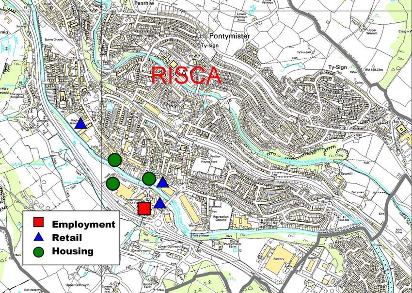
Figure 1
37Strategic Options Workshop Paper
2.7 Employment Sites: Oakdale and Penyfan serve a dual
purpose, functioning as key employment sites within the
community plan area. Access to these sites has been significantly
improved from the south with the opening of the Sirhowy
Enterprise Way. Woodfieldside and Springfield business parks also
provide subsidiary employment sites within the area.
2.8 Figure 1 Identifies the primary town centres, residential and
employment sites within the Mid Valleys East Community Plan
Area.
3 External Linkages
3.1 North / South: The district benefits from strong southward
links connecting the area with the towns of Abercarn, Risca and
NEWPORT via the A467. This road extends north of Crumlin
providing access to the towns of Abertillery and Ebbw Vale outside
the borough. There are limited transport links north of Blackwood
to the Heads of the Valleys with the only access provided along the
A4048 to Tredegar.
3.2 The district suffers from an absence of active passenger rail
lines. The nearest rail link being Ystrad Mynach Station on the
Rhymney Valley Line which connects with Blackwood town centre
via a once hourly bus service.
3.3 Proposals for the re-opening of the Ebbw Rail Line have been
approved which will provide linkages through Crumlin and
Newbridge to the Heads of the Valleys Newport and Cardiff.
3.4 East / West: The primary links in this district are of an
east/west grain. The A472 provides the primary cross-valley
linkages joining Newbridge, Pontllanfraith, Maesycwmmer and
Ystrad Mynach. In terms of relating to settlements outside the
borough, the A472 extends further east to Pontypool. There are no
rail links on an east/west axis due to the characteristic valley
formation of the land
3.5 Figure 2 depicts the main road network and rail linkages in the
Mid Valleys East. Community Plan Area
38Strategic Options Workshop Paper
Figure 2
4 Area Potential
4.1 The area has the potential to consolidate its growth and
develop its strength as a sub-regional Centre.
4.2 Blackwood and Newbridge. Building on its existing strengths
Blackwood has the potential to provide greater variety of consumer
goods supporting needs at the sub-regional level. This will be
recognised with the development of new retail units on the edge of
town and environmental improvements to the existing urban fabric
of the town centre. Access to and from the town centre will be
improved following the completion of the new bus station.
39Strategic Options Workshop Paper
4.3 Newbridge has already established itself as an area for sports
and recreation. This will be enhanced with the opening of the new
rail halt providing improved access to recreational facilities, the
riverside environment and the surrounding landscape of the
Crumlin Valley. Exploiting these benefits there will be the
opportunity to establish more service based commerce such as
cafes and bars serving the needs of people visiting the area for its
recreational value.
4.4 Figure 3 shows the relationship between settlements within
and surrounding the Community Plan Area.
Figure 3
4.5 Together with other settlements located along the A469
transport corridor, the opening of the Ebbw Vale rail line will for the
40Strategic Options Workshop Paper
first time provide increased connectivity with Cardiff. This may
provide an opportunity to tap into a new market and encourage
inward migration into the area.
4.6 Events: Caerphilly balloon festival, held in Blackwood,
continues to attract a wealth of tourism to the area throughout its
duration. This event could be further capitalised with successful
marketing. Staging other events (i.e. town festival/culture festival
for the valleys etc) around the same time may provide a stronger
hook for tourism with a potential fortnight or month of events
throughout the borough. Events held at Bute town Conservation
Area, Bargoed Big Bed, Caerphilly Big Cheese, Blackwood Balloon
festival, foreign food markets etc would culminate in a period of
tourism based activities which together may work more
successfully in attracting people to the area.
4.7 Industry and Employment: Sirhowy Enterprise Way (SEW).
The scheme is located in the heart of the Sirhowy Valley and
improves the A4048/A472 strategic highway network through the
mid valleys east district. It consists of a new single carriageway
road 3.4km long with two key cross valley links. The ‘Chartists
Bridge’ provides the primary cross valley linkage from the A469
north of Blackwood to Oakdale Business Park. In addition, the
landmark bridge provides a key focal point an attraction to the
town.
4.8 Completion of the scheme has already been instrumental to
the development of Oakdale Business Park and has the potential
to open up more land upon Oakdale upland plateau for business
use culminating in around 12,000 – 15,000 prospective new jobs.
5 Analysis:
5.1 In order for the urban cluster to function effectively, the
following issues need to be addressed in the district:
• Blackwood town centre needs to diversify its
constituent units to incorporate more leisure uses reflecting
local demand.
• Formal and commercial leisure opportunities need to
be further developed with improved access to facilities in
Markham, Argoed and Trinant. There is currently no cinema
41Strategic Options Workshop Paper
in the district with the closest multiplex found outside the
borough in Nantgarw, (RCT).
• Newbridge needs to embrace the opportunities of the
new rail halt and establish itself as a focus for sports and
recreation.
• Road links between Blackwood and the Heads of the
Valleys towns need to be improved allowing access to
employment sites at Oakdale and Penyfan. Currently there is
indirect access via Bargoed / Cefn Fforest-Aberbargoed.
• Capitalise on the intrinsic environmental attraction of
the Crumlin Valley around Newbridge as more people are
accessible to the area via the new rail halt.
• No rail link in Blackwood, despite it being the major
town centre in the centre and north of the borough. Improved
inter-modal transport options between Blackwood and Ystrad
Mynach, Blackwood and Newbridge is imperative to allow
access to facilities and employment in and outside the area.
• Penyfan Ponds and the wider rural area has the
potential to play an increased role as an area of informal
recreation.
5.2 In order to function as part of the South East Wales integrated
city region, the following issues need to be addressed;-
Improvements in inter-modal transport options need to be
established linking Blackwood efficiently with Ystrad Mynach
train station and the forthcoming rail halt at Newbridge. This
will allow improved access to Cardiff, Newport and the
Heads of the Valleys and reduce commuter traffic.
Existing residential areas need to be made more attractive
and new residential sites identified in order to halt net
migration outflow from the Mid Valleys Corridor. This should
include a wider mix of housing, prioritising locations with
easy access to sustainable modes of transport, particularly in
view of the re-opening Ebbw Valley rail link.
Provide improved access from the Blackwood/Oakdale sub-
region to the heads of the valleys. A strategic road network
linking Penyfan/Oakdale business parks with the north will
provide increased employment opportunities.
42Strategic Options Workshop Paper
6 Individual Settlement Functions and Future
Opportunities
Blackwood.
6.1 The town functions as a sub-regional centre whose sphere of
influence runs across the mid-valleys corridor. The town has the
potential to increase service provision with improved transport links
following the redevelopment of Blackwood Bus Station and the
development of new retail units on the periphery of the town. The
completion of the Sirhowy Enterprise Way also provides the
opportunity to attract further inward investment to the town in the
form of larger commercial and industrial units (dependent on the
LDP strategy).
Newbridge.
6.2 The town serves an important role in providing local amenities
and services. In addition, Newbridge has established itself as an
area for sports and recreation. There will be the opportunity to
expand this further with the opening of the Ebbw Valley Rail Line
which will allow improved access to Newbridge. This in conjunction
with the enhancement of Newbridge town centre and riverside
environment will greatly improve Newbridge’s appeal as a place to
visit and make a home. Exploiting these benefits there will also be
the opportunity to establish ancillary commerce such as cafes and
bars serving the needs of people visiting the area for its sporting
facilities, pleasant riverside environment and attractive town
centre.
Pontllanfraith
6.3 Pontllanfraith functions as a residential settlement with house
types ranging from small family homes to larger executive housing.
The village contain three small neighbourhood centres serving
local needs, although primary provision is provided by nearby
Blackwood town centre.
Oakdale
6.4 Oakdale serves a dual purpose . Its initial function is that of a
residential settlement within the direct influence of both Blackwood
and Newbridge. However, following further development at
Oakdale business park and the opening of the SEW, its role within
the plan area is changing. Oakdale is now becoming synonymous
with its business park , which constitutes much of the upland
plateau to the rear of the settlement. It is likely that further
43Strategic Options Workshop Paper
development spurred by the SEW will consolidate its role as a key
employment site within the plan area with the potential of providing
12 – 15,000 new jobs.
Trinant & Aberbeeg
6.5 Trinant serves predominantly as a residential satellite village to
the north of Croespenmaen. The village is isolated with poor
transport communications and contains few services or amenities.
The topography of the land and substandard communications
dictates that it relates poorly to other settlements within the
borough.
6.6 Aberbeeg functions as a small residential hamlet, although
containing a small district hospital- due for closure. Its location
dictates that it relates more to Ebbw Vale and Abertillery rather
than other local or sub regional centres within Caerphilly County
Borough.
6.7 There is potential for the expension of these settlements for
further residential purposes (subject to the LDP strategy), although
this is unlikely given their location.
Crumlin
6.8 Crumlin serves as a residential suburb of Newbridge, and
benefits from its own small neighbourhood centre. By virtue of its
strategic location along the A469, Crumlin relates more to towns
located along this transport corridor including Abertillery, Abercarn
and Newport rather than towns within the community plan area. It
is likely that the re-opening of the Ebbw Valley rail line will increase
the town’s desirability, although there is limited opportunity for
further expansion due to the topography of the land in this area.
Markham / Argoed/Hollybush
6.9 These smaller villages function primarily as rural residential
settlements. In terms of their relationship to other settlements,
these small villages located along the A4048 are within the
influence of both Blackwood town centre to the south and to
Tredegar in the north. These settlements are surrounded by
undeveloped farmland and upland plateau, which subject to
strategy may provide the opportunity for expansion.
Cefn Fforest/Fleur-de-Lis/Pengam
6.10 These villages form part of the wider Blackwood urban area
and largely constitute residential settlements that have coalesced
44Strategic Options Workshop Paper
over time. Due to their proximity to Blackwood town centre, these
villages primarily function as residential neighbourhoods and are
developed to a sufficient capacity.
45You can also read