Oxfordshire Fens Project Hinksey Heights Baseline Report - Freshwater ...
←
→
Page content transcription
If your browser does not render page correctly, please read the page content below
Oxfordshire Fens Project
Hinksey Heights Baseline Report
            David Morris
             May 2019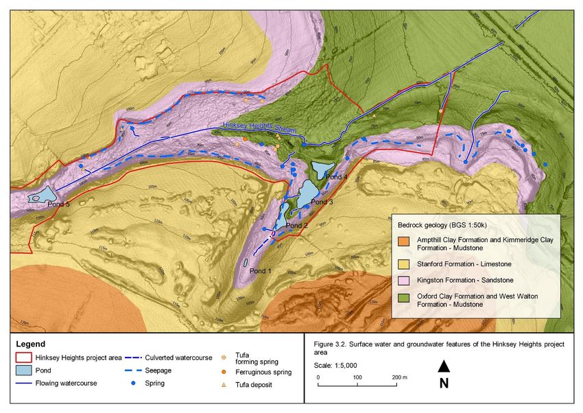
Contents
1.       Introduction................................................................................................................ 1
  1.1.      Background ............................................................................................................. 1
  1.2.      Purpose and structure of this report ........................................................................ 1
2.       Baseline study methods ........................................................................................... 3
  2.1.      Study overview and data management ................................................................... 3
  2.2.      Desk study ............................................................................................................... 3
  2.3.      Field survey ............................................................................................................. 4
  2.4.      Nomenclature .......................................................................................................... 6
3.       Baseline study results .............................................................................................. 7
  3.1.      Topography and geomorphology ............................................................................. 7
  3.2.      Geology ................................................................................................................... 7
  3.3.      Hydrology ...............................................................................................................12
  3.4.      Hydrogeology .........................................................................................................14
  3.5.      Habitats and vegetation ..........................................................................................17
  3.6.      Biodiversity .............................................................................................................30
4.       References ............................................................................................................... 35
Appendix 1. Photographs ............................................................................................... 36
Appendix 2. Site list ......................................................................................................... 40

Tables
Table 3.1. Description of bedrock units outcropping within and around the Hinksey Heights
study area ............................................................................................................................. 8
Table 3.2. Habitats within the surface water and groundwater catchments of the Hinksey
Heights study area ...............................................................................................................13
Table 3.3. Priority habitats within the Hinksey Heights project area ....................................17
Table 3.4. Summary of taxa recorded from the Hinksey Heights study area .......................30
Table A2.1. Explanation of legal and conservation statuses of taxa recorded from the
Hinksey Heights study area. ................................................................................................40
Table A2.2. List of taxa recorded from the Hinksey Heights study area. .............................41

Figures
Figure 1.1. Site plan of the Hinksey Heights project area ..................................................... 2
Figure 3.1.Topography and surface water catchment of Hinksey Heights project area ........ 9
Figure 3.2. Geology and groundwater catchment of Hinksey Heights project area .............10
Figure 3.3. Surface water and groundwater features of the Hinksey Heights project area ..11
Figure 3.4. Habitats within the surface water and groundwater catchments of the Hinksey
Heights project area ............................................................................................................16
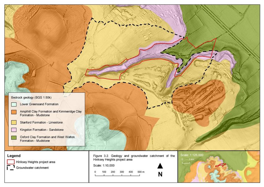
Figure 3.5. Habitats of the Hinksey Heights project area .....................................................21
Figure 3.6. Priority habitats of the Hinksey Heights project area .........................................23
Figure 3.6. Legend to plant communities .............................................................................25
Figure 3.8. Vegetation of the Hinksey Heights project area .................................................26

Hinksey Heights Baseline Report

1. Introduction
1.1. Background
The Oxfordshire Fens Project is undertaking habitat restoration work to re-establish alkaline
fen at Hinksey Heights. The project area is located between the Hinksey Heights Golf Club
and North Hinksey (grid reference SP 493 043), situated in a valley draining the high
ground of the mid-vale ridge to the west of Oxford. A plan of the project area is provided in
Figure 1.1.
This report refers to the following units within the project area, shown in Figure 1.1:
•   Harcourt Hill Scrub Local Wildlife Site – the mostly wooded valley designated as a Local
    Wildlife Site (LWS);
•   Field 1 – an undesignated field at the eastern end of the valley; and
•   Field 2 – an undesignated field in a smaller valley to the south of the LWS.

1.2. Purpose and structure of this report
The purpose of this report is to provide information gathered through desk study and field
survey to form a baseline understanding of the hydro-ecology and biodiversity of the project
area.
Section 2 of this report describes the methods followed and sources of information used for
the desk study and field survey undertaken. Section 3 presents the results of this work,
under the following topic headings:
•   topography and geomorphology;
•   geology;
•   hydrology;
•   hydrogeology;
•   habitats and vegetation; and
•   biodiversity.

                                                                                            1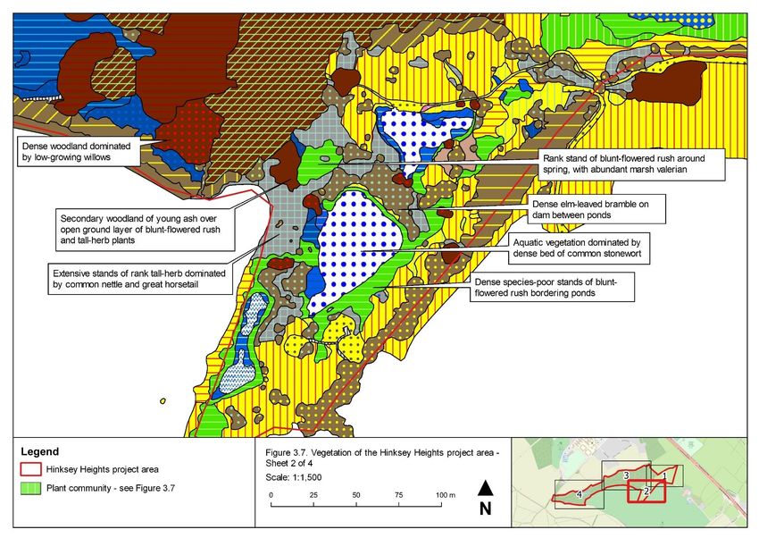
Hinksey Heights Baseline Report
Figure 1.1. Site plan of the Hinksey Heights project area

                                                            2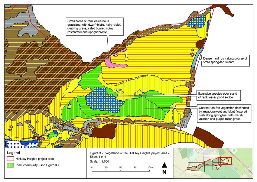
Hinksey Heights Baseline Report

2. Baseline study methods
2.1. Study overview and data management
The baseline study of the project area comprised a desk study to gather background
information, with more detailed information gathered by field survey. The methods for these
elements are described below.
All biological records obtained during the desk study and made during the field survey were
entered into a Microsoft Access database set up for the study. All spatial data obtained or
created during the desk study and field survey were gathered in a GIS project in QGIS
(QGIS Development Team, 2019).

2.2. Desk study
The following sources of information were used for the desk study:
•   Biological records:
    -    boundaries of LWS and proposed LWS made available by Thames Valley
         Environmental Records Centre (TVERC);
    -    biological records made available by TVERC in July 2018;
    -    biological records downloaded in March 2019 from the National Biodiversity
         Network Atlas (NBN, 2019);
    -    records of bryophytes recorded from the project area on 7th January 2018,
         obtained from the British Bryological Society; and
    -    records of fungi, vascular plants and invertebrates compiled by and obtained from
         Dr Judy Webb, collected at various dates up to 2018.
•   Water quality data:
    -    results of water quality testing within the project area undertaken as part of the
         Freshwater Habitats Trust project Clean Water for Wildlife (Freshwater Habitats
         Trust, 2016), provided by Dr Jeremy Biggs.
•   Spatial data:
    -    2017 1m LiDAR Digital Terrain Model (DTM) obtained from the data.gov.uk portal;
    -    British Geological Society (BGS) bedrock and superficial geological mapping
         obtained through the BGS Web Mapping Service;
    -    The Ordnance Survey (OS) Open Data products Open Rivers and Terrain® 50;
    -    freely available background mapping such as OpenStreetMap; and
    -    Google Earth satellite imagery.
The above spatial data were used to:
•   map the locations of watercourses and other hydrological features;
•   calculate the topographical catchment of the project area, using the LiDAR DTM and the
    SAGA terrain analysis processing tools in QGIS;

                                                                                              3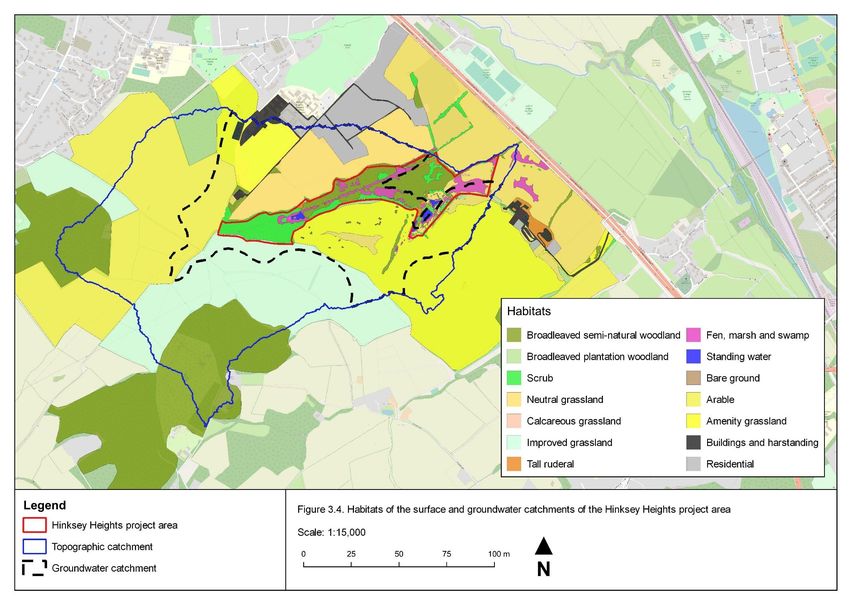
Hinksey Heights Baseline Report

•   map the habitats within the topographical catchment of the project area using Google
    satellite imagery, using the following broad habitats, based on the Phase 1 habitat
    classification (JNCC 2010) (cf. Section 2.3):
    -    broadleaved semi-natural woodland;
    -    broadleaved plantation woodland;
    -    scrub and hedgerows;
    -    neutral grassland;
    -    improved grassland;
    -    arable;
    -    amenity grassland;
    -    residential properties and gardens; or
    -    other buildings and hardstanding.
•   redraw geological boundaries from the BGS 1:50,000 bedrock geological mapping by
    identifying topographic features from the LiDAR DTM.

2.3. Field survey
Field survey work comprised the following survey elements, the methods of each of which
are described below:
•   hydrological walkover;
•   botanical survey;
•   habitat and vegetation survey; and
•   invertebrate survey.
The hydrological walkover and botanical, habitat and vegetation surveys were undertaken
by David Morris, beginning 21st July 2018 and continuing over subsequent ad hoc visits to
April 2019. The invertebrate sampling was undertaken during a single visit to the project
area by Dr Judy Webb in July 2018.
Records of other taxonomic groups observed incidentally during site work, such as birds,
were also gathered over this period. Representative photographs of features of the project
area were collected, taken using an Olympus Tough® compact camera.
Hydrological walkover
The following surface water and groundwater features were recorded during site visits:
•   bodies of open water, e.g. ponds;
•   watercourses, e.g. ditches and streams;
•   areas of diffuse groundwater discharge (seepages);
•   areas of discrete groundwater discharge (springs); and
•   deposits of calcite precipitated from groundwater (tufa).

                                                                                             4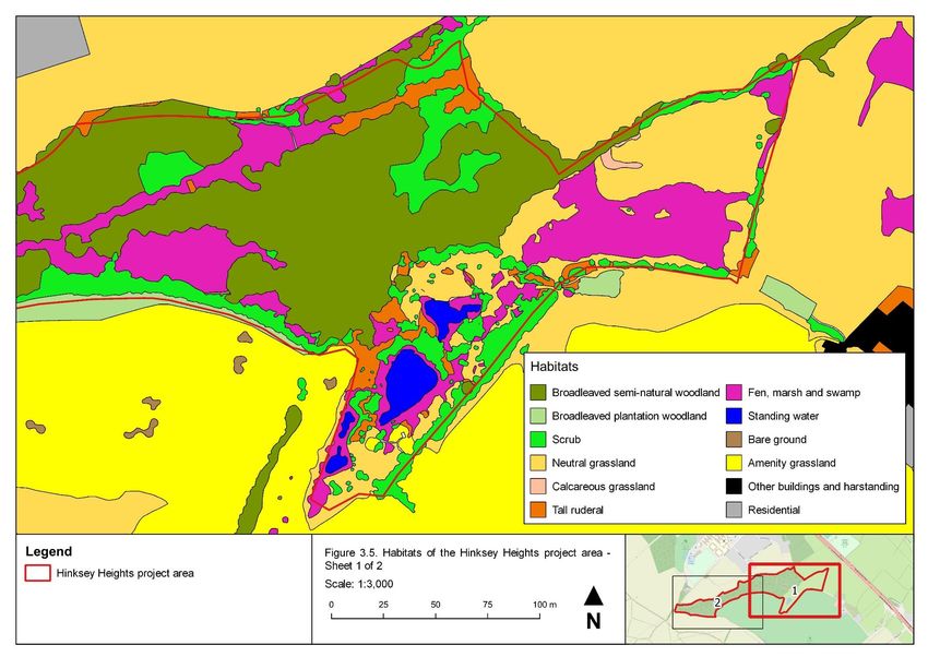
Hinksey Heights Baseline Report

The direction of flow of watercourses was recorded. If springs showed evidence of tufa
formation or concentrations of iron oxide, then this was also recorded. Hydrological features
were recorded as waypoints using a Garmin eTrex® 10 handheld Global Positioning
System (GPS) unit (horizontal accuracy approximately 5m) or recorded on field maps.
Features were digitised in QGIS. Watercourse channels and the extents of ponds were
digitised using the LIDAR DTM.
Botanical survey
All stonewort, bryophyte and vascular plant taxa encountered during the survey were
recorded, with separate lists compiled for the three units of the project area. Each taxon
recorded was assigned a relative frequency using the DAFOR scale (Dominant, Abundant,
Frequent, Occasional, Rare). The qualifier ‘local’ was added to indicate a heterogeneous
distribution, e.g. LF for ‘locally frequent’.

Particular note was taken of the following vascular plant taxa:
•   legally protected species listed on Schedule 8 of the Wildlife and Countryside Act 1981
    (as amended); and
•   plants of local or national conservation concern:
    -    species of principal importance, listed in accordance with Section 41 of the Natural
         Environment and Rural Communities (NERC) Act 2006;
    -    Nationally Rare or Nationally Scarce taxa (BSBI, 2017);
    -    taxa listed as Near Threatened, Vulnerable, Endangered or Critically Endangered
         on the vascular plant red lists for Great Britain (Cheffings et al., 2005) or England
         (Stroh et al., 2014); or
    -    taxa listed as rare or scarce in the administrative county of Oxfordshire (Killick et
         al., 2018).
Note was also taken of invasive non-native plant taxa, such as those listed on Schedule 9
of the Wildlife and Countryside Act 1981 (as amended), or other invasive or potentially
invasive non-native plants.
Where a notable or invasive plant taxon occurred in a discrete population then a ten-figure
grid reference of its location was recorded using a Garmin eTrex® 10 handheld GPS unit
(horizontal accuracy approximately 5m) and ecological notes were recorded.
Habitat and vegetation survey
The methodology of the National Vegetation Classification (NVC) was followed to classify
the vegetation of the project area (Rodwell, 2006). Homogenous stands of vegetation were
mapped and assigned to units of the NVC, to sub-community where possible. Assignment
of units of the NVC was largely made in the field. Quadrat samples of stands were not
recorded. Some vegetation could not be assigned to units of the NVC and was assigned to
ad hoc units, e.g. disturbed, early successional or artificial habitats or stands of single
species not included in the NVC.
Vegetation mapping was detailed. Complex vegetation was mapped at a scale of
approximately 1:1,500, with stands resolved as polygon features if having an area greater
than approximately 1m2. Simpler vegetation, such as woodland, was mapped at a larger
scale. Mapping was undertaken using field survey maps produced in QGIS, comprising

                                                                                                 5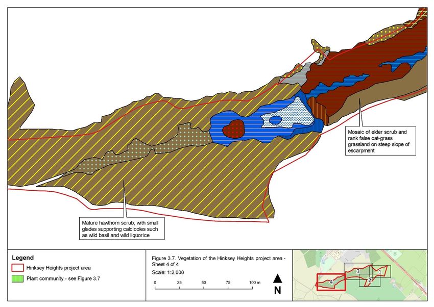
Hinksey Heights Baseline Report

Google satellite imagery at an appropriate scale and overlain with 100m and 10m OS grids.
The survey maps were printed and annotated in the field, using a Garmin eTrex® 10
handheld GPS unit to locate positions (horizontal accuracy approximately 5m). Completed
field survey maps were scanned, and georeferenced and digitised in QGIS.
The survey aimed to cover the whole project area but areas supporting wetland habitats
were targeted. Areas not covered or not adequately covered during the survey, such as
peripheral areas of dry woodland, were mapped from Google satellite imagery and the
vegetation classified based on observations from nearby.
Stands were also assigned to the following broad habitats, based on the Phase 1 habitat
classification (JNCC, 2010) (cf. Section 2.2):
•   broadleaved semi-natural woodland;
•   broadleaved plantation woodland;
•   scrub and hedgerows;
•   neutral grassland;
•   calcareous grassland;
•   improved grassland;
•   tall ruderal;
•   fen, marsh and swamp;
•   open water;
•   arable;
•   amenity grassland;
•   residential properties and gardens; or
•   buildings and hardstanding.
Results of the habitat and vegetation survey were evaluated to identify priority habitats (i.e.
habitats listed in accordance with Section 41 of the Natural Environment and Rural
Communities Act 2006, as being of principal importance for the conservation of biodiversity)
using the definitions provided by the Joint Nature Conservation Committee (Maddock,
2011).
Invertebrate survey
The invertebrate survey was undertaken by sweep netting during a single visit by Dr Judy
Webb in July 2018. The survey visited a limited area of the site and limited range of habitats
but aimed to give an initial indication of the diversity of species of true fly (Diptera)
associated with herbaceous fen and wet woodland. Craneflies (Tipulidae) and fungus gnats
(Sciaridae) collected were sent for determination to Alan Stubbs and Peter Chandler,
respectively, but invertebrates were otherwise identified by Dr Judy Webb.

2.4. Nomenclature
Nomenclature throughout this report follows the latest MapMate® species dictionary
(Mapmate Limited, 2019), e.g. Stace (2010) for vascular plants.

                                                                                              6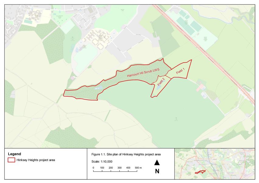
Hinksey Heights Baseline Report
3. Baseline study results
This section presents baseline information about the Hinksey Heights project area,
gathered from desk study and field survey. This information is divided into the following
topics:
• topography and geomorphology;
• geology;
• hydrology;
• hydrogeology;
• habitats and vegetation; and
• biodiversity.
Photographs from the project area are provided in Appendix 1.
3.1. Topography and geomorphology
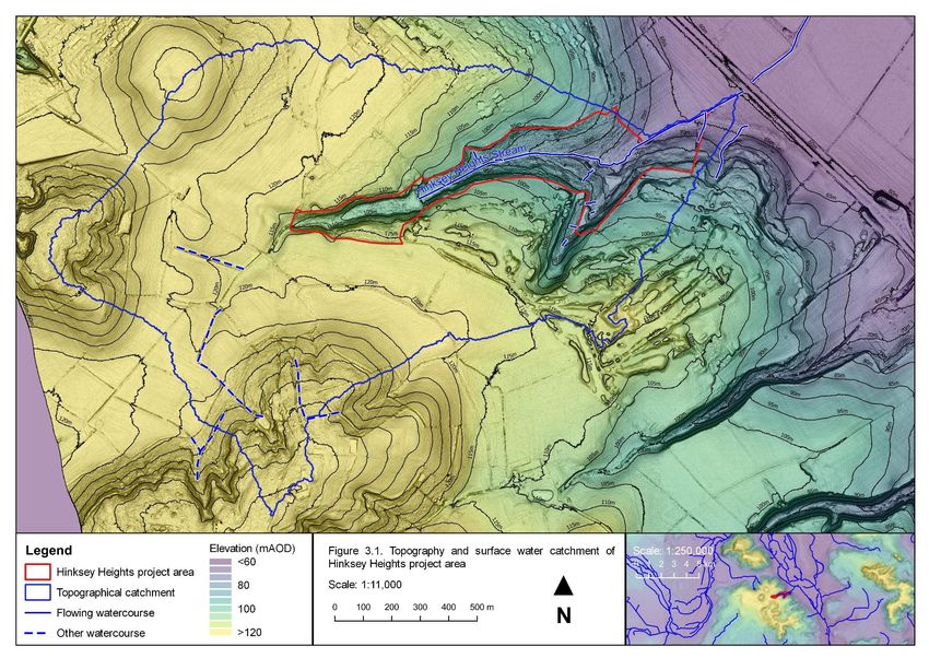
The topography of the project area is shown in Figure 3.1. The project area comprises a
narrow valley cut into the high ground of the mid-vale ridge to the west of Oxford. The valley
is open at the eastern end, with a long main valley oriented approximately west-south-west
to east-north-east, within the LWS, and a smaller valley joining from south-south-west. The
latter valley includes Field 2 and extends beyond the project area south into the golf course.
The project area varies in elevation from a low of approximately 60m above Ordnance
Datum (mAOD) along the A34 at its eastern end to approximately 110mAOD at the western
end of the main valley. The width of the main valley tapers from east to west, from
approximately 275m wide at the eastern end to 75m wide below the pond toward the west,
to approximately 25m wide at the western end of the project area.
There are numerous breaks in slope within the project area, particularly on the southern
slopes. The tops of the valleys are marked by well-defined escarpments, with slopes of
approximately 20-25%. This break in slope varies in elevation between 90-100mAOD on
the northern side and 90-95mAOD on the southern side. Most of the project area is on
slopes and there is no well-defined valley bottom until the ground opens out at the eastern
end, in the centre of the project area, and within the smaller southern valley. The slope of
the sides of the main valley through most of its length is approximately 10%, particularly on
the northern side which has a more consistent slope.
3.2. Geology
The geology of the project area is shown in Figure 3.2, modified from the BGS 1: 50,000
geological mapping. There are no superficial deposits mapped for the project area, but
there are extensive deposits of tufa (travertine) and peat within the main valley. Along the
slopes of the main valley are numerous very large solid concretions of tufa around springs,
as well as more diffuse deposits. The main stream through the valley (see Section 3.3) also
supports extensive tufa concretions along its banks, and there are several reaches where
7Hinksey Heights Baseline Report
large tufa barrages have formed within the channel (Photograph 1, Appendix 1), mainly in
the lower, less modified reaches. The peaty deposits have not been investigated. Casual
observation suggests these are relatively shallow and loamy and, in many areas, form a
loose matrix with calcite precipitated by groundwater emergence.
The bedrock geology of the project area and its surroundings are dominated by Jurassic
rocks, summarised in stratigraphical sequence in Table 3.1. The bedrock formations
outcropping within the site largely belong to the Corallian Group. This is a complex
succession of interdigitating limestones, marls, sandstones, sands, siltstones, silts,
spiculites and mudstones, here represented by outcrops of the limestone of the Stanford
Formation above the valley and sandstone of the Kingston Formation along the valley
sides. The Oxford Clay Formation outcrops at lower elevations, forming the valley bottom in
the eastern part of the project area. The Kimmeridge and Ampthill Clay Formation outcrops
on the higher ground around the site, and the Lower Greensand Group forms the summits
of Boar’s Hill and Hurst Hill, to the south and west, respectively.
Table 3.1. Description of bedrock units outcropping within and around the Hinksey Heights
study area (BGS, 2019)
Bedrock unit Lithological description
Lower Mainly sands and sandstones (varying from well-sorted fine-grained to
Greensand poorly sorted medium- to coarse-grained) with silts and clays in some
Group intervals.
Kimmeridge and Mudstone
Ampthill Clay
Formation
Stanford Generally medium-grained quartzose sands, locally fine- and coarse-
Formation grained, with carbonate cemented beds and doggers which are sandy
limestone or calcareous sandstone; some beds of spiculitic sandstone
which are relatively sand-free, shelly and/or ooidal limestone, sandy or
silty mudstone, and calcareous mudstone. Strata are generally grey when
fresh, weathering to brown or yellow.
Kingston Shell detrital limestones, ooidal limestone, coralline limestone,
Formation fossiliferous marls, and interbedded limestone, marl and mudstone.
Oxford Clay Mudstone
Formation
8Hinksey Heights Baseline Report
Figure 3.1.Topography and surface water catchment of Hinksey Heights project area
9Hinksey Heights Baseline Report
Figure 3.2. Geology and groundwater catchment of Hinksey Heights project area
10Hinksey Heights Baseline Report
Figure 3.3. Surface water and groundwater features of the Hinksey Heights project area
11Hinksey Heights Baseline Report
3.3. Hydrology
Surface water features
The surface water features identified within and around the project area are shown in
Figure 3.1 and Figure 3.3. The project area is drained principally by a watercourse along
the bottom of the main valley, hereafter referred to as the Hinksey Heights Stream
(Photograph 1, Appendix 1), which flows west to east down to the Thames floodplain. The
stream rises at or just to the west of the pond at the head of the valley. There is a channel
continuing up the valley west and out of the project area, but it was dry when investigated in
July 2018. The outlet from the project area is culverted beneath the A34. The stream
channel has been artificially deepened and straightened along most of its length and there
are remains of concrete dams in places. The stream is not classed as Main River by the
Environment Agency.
There are five artificial ponds within and around the project area, one at the head of the
main valley (shown as Pond 5 on Figure 3.3) and four in the smaller valley (Ponds 1 to 4),
one of which (Pond 1) is within the golf course and outside the project area. The latter four
ponds form a south-north group, with a dam between the northern two ponds and a dam
across the northern side of the northern-most pond.
The pond at the head of the main valley (Pond 5) is formed behind a dam across the
Hinksey Heights Stream and drains directly into the Hinksey Heights Stream. The drainage
of the other ponds is not clear. The pond in the golf course (Pond 1) drains north into the
southern-most of the ponds within the project area (Pond 2) via a watercourse. This is
largely culverted but has a short open stretch within the golf course. One land drain was
observed discharging via a plastic pipe into this open watercourse in April 2019 and there is
likely further land drainage in this area. There is a short open watercourse draining into the
pond immediately to the north (Pond 3) and at the top of this watercourse is a buried
chamber with two inlets, one of which was running in April 2019. This water could originate
from the pond to the south (Pond 2), but there was no obvious outfall from this pond and
there could be inputs from land drainage from the golf course. The water of the two
southern ponds (Ponds 1 and 2) was much more turbid than that of the two to the north
(Ponds 3 and 4), suggesting these two pairs of ponds may not be directly connected.
There was no obvious outfall for the pond to the north (Pond 3) but there was a shallow
linear depression extending from the eastern corner which may function as an overflow
channel. Similarly, there was no obvious outfall for the northern pond (Pond 4), but it was
observed to flow overland and under the boardwalk and down-gradient toward the Hinksey
Heights Stream during the winter of 2019 when the level was high. There is a stone culvert
in the bank of the Stream to the north, below the level of the field, and which has been
observed to discharge water into the stream; it may be connected to the pond or be an old
tiled land drain.
The northern of the four ponds (Pond 4) has a small pump house on its eastern bank, with
a pipe connecting the two. Presumably, this pump supplies water to the golf club for
watering the course. Over the dry hot weekend of 20th April, pumping had caused a
significant drawdown of around 0.5m.
12Hinksey Heights Baseline Report
The four ponds within the project area sustained high water levels throughout the dry
summer of 2018, and the northern two of the four ponds within the smaller valley (Ponds 3
and 4) have always been observed to have very clear water. With no significant surface
water inputs, the ponds therefore appear to be supplied by groundwater. Similarly, the
Hinksey Heights Stream runs year-round, and it is likely sustained by a significant base-flow
derived from groundwater.
In addition to the watercourses described above, there are several other watercourses
within and around the project area. Within the project area, additional watercourses
comprise small channels draining springs, such as on the slopes above the A34. Outside
the project area, watercourses are shown on maps near to the summit of Boar’s Hill to the
south-west, within the surface water catchment of the project area (Figure 3.1). These may
rise from springs at the junction of the Lower Greensand and Kimmeridge and Ampthill
Clays (Figure 3.2). They may feed into the surface drainage network flowing through the
main valley or could infiltrate to ground once they reach more permeable strata lower down.
Water quality
Water quality testing was undertaken by volunteers for the Freshwater Habitats Trust on
27th March 2016. A sample of water was collected from the Hinksey Heights Stream at the
eastern end of the main valley at approximately SP 49617 04435, and the nitrate (NO3-)
and phosphorus (P) were measured using simple solution-based kits provided by the
Freshwater Habitats Trust (further details of the sampling method are available at
https://freshwaterhabitats.org.uk/projects/clean-water/). The sample found concentrations of
0.02-0.05ppm and 0.2-0.5ppm of nitrate and phosphorus, respectively. These values
indicate no evidence of pollution.
Topographical catchment
The upslope area of the project area is shown in Figure 3.1. This topographical catchment
has an area of approximately 204ha, mostly comprising the area around Hinksey to the
north and Boars Hill to the south. The habitats within the catchment are shown in Figure 3.4
and summarised by area in Table 3.2.
Table 3.2. Habitats within the surface water and groundwater catchments of the Hinksey
Heights study area
Habitat Catchment / Area (ha) (% of catchment area)
Surface water Groundwater
Arable 39.2 (19.2%) 8.3 (9.0%)
Bare ground 0.1 (0.1%) 0.1 (0.2%)
Broadleaved semi-natural woodland 35.3 (17.3%) 5.9 (6.4%)
Buildings 2.0 (1.0%) 2.0 (2.2%)
Calcareous grassland 0.0 (0.0%) 0.0 (0.0%)
Fen, marsh and swamp 4.4 (2.2%) 3.4 (3.7%)
Improved grassland 41.9 (20.6%) 7.6 (8.3%)
13Hinksey Heights Baseline Report
Habitat Catchment / Area (ha) (% of catchment area)
Surface water Groundwater
Neutral grassland 24.2 (11.8%) 21.0 (22.8%)
Plantation woodland 5.5 (2.7%) 0.7 (0.7%)
Residential 3.6 (1.8%) 3.6 (3.9%)
Scrub 8.2 (4.0%) 7.1 (7.7%)
Sport / amenity 38.1 (18.7%) 32.3 (35.1%)
Standing water 0.5 (0.3%) 0.2 (0.3%)
Tall ruderal 0.8 (0.4%) 0.4 (0.5%)
3.4. Hydrogeology
Evidence of groundwater
The hydrogeological features of the project area identified from field survey are shown in
Figure 3.3. The project area showed extensive groundwater emergence along the sides of
the valleys and slopes, marked out by sharply-defined transitions from dry scrub, woodland
or grassland to wet woodland, tall-herb fen or other wetland vegetation (see Section 3.5 for
descriptions). Within the main valley, from the pond at the head of the valley to the smaller
valley to the east, groundwater appears to emerge in a zone extending high up the valley
sides. Along the length of the main valley are numerous springs, on both the northern and
southern sides, several of which have very large tufa concretions (Section 3.2) and some
are conspicuously iron-rich. Springs appeared to extend further west up the valley on the
northern compared to the southern side. There is a zone of particularly strong spring flow in
woodland at the eastern end of the main valley, with large spring mounds, and permanently
saturated ground, tufa and runnels extending across much of the slope above the Hinksey
Heights Stream. Springs additional to those identified in Figure 3.2 may be present but
currently obscured by overgrown vegetation.
There does not appear to be any groundwater emergence upstream of the pond at the
western end of the main valley, above around 100mAOD. In the central part of the project
area where the two valleys meet, the area below a break in slope at around 79mAOD
appeared to have limited or no groundwater influence. Groundwater emergence in the
smaller valley within Field 2 appeared to be constrained, with narrower areas of seepage
situated above the ponds.
Evidence of groundwater emergence continues east from the valley, on the slopes above
the A34. There is a zone of groundwater emergence, including several springs, at
elevations between approximately 73 and 80mAOD. Two small watercourses rise from
these springs, one of which is outside the project area. The zone of groundwater influence
is narrower than within the main valley, confined to a series of breaks in slope at higher
elevations, above vegetation with little or no apparent groundwater influence.
As described above, the five ponds within the project area are likely to be groundwater
supplied.
14Hinksey Heights Baseline Report
Hydrogeological catchment
There are no BGS records of boreholes within or near to the project area from which to infer
information about groundwater levels or flows. The nearest boreholes recorded within the
bedrock formations within the groundwater catchment of the project area are to the north in
Hinksey and to the south in the Boar’s Hill area and no groundwater strikes were recorded
from these.
The groundwater catchment of the project area is likely to be more limited than the surface
water catchment due to the presence of extensive outcroppings of the Kimmeridge and
Ampthill Clay Formation across the high ground to the west and south of the project area.
These relatively impermeable strata are likely to limit infiltration in the higher areas, with
relatively greater run-off compared to the more permeable strata of the Corallian Group
lower down. Recharge of springs on the northern slope of the main valley is therefore most
likely to occur within the fields between the main valley and Hinksey to the north. Springs
on the southern slopes are likely to be recharged mainly from the golf course to the south.
Flows within the Corallian Group will be confined below by the Oxford Clay, which is an
aquitard, and its outcropping in the eastern part of the valley largely corresponds with the
locations of springs. There does not appear to be any indication that groundwater flows
along the dip of the strata, i.e. north-west to south-east, springs being evenly distributed
around the project area. Flows therefore likely largely follow topography.
The valley of the project area forms the second in a north-to-south sequence of valleys
along the mid-vale ridge: Raleigh Park to the north, and Chilswell Valley and Limekiln
Copse to the south-east. These valleys support similar spring-fed wetlands and are at
similar elevations to the study, again corresponding to outcroppings of the Oxford Clay.
Given the similarity in elevation, the topographic watersheds between these valleys likely
also represent approximate groundwater divides.
The hydrogeological catchment of the spring-fed areas described above is shown in Figure
3.2. It has a total area of approximately 92ha. The habitats within the catchment are shown
in Figure 3.4 and summarised by area in Table 3.2.
15Hinksey Heights Baseline Report
Figure 3.4. Habitats within the surface water and groundwater catchments of the Hinksey Heights project area
16Hinksey Heights Baseline Report
3.5. Habitats and vegetation
Summary
The habitats within the project area are shown in Figure 3.5. Seven priority habitats were
identified within the study area, summarised in Table 3.3 and shown in Figure 3.6. The
vegetation of the study area is shown in Figure 3.8 and described by broad habitat below.
The four ponds within the project area (see Section 3.3) comprise Ponds priority habitat as
at least Pond 4 supports common toad (Bufo bufo) and great crested newt (Triturus
cristatus) (see Section 3.6). As the four ponds are nearby and connected by suitable
terrestrial habitat, they are likely all used by one or both species.
Table 3.3. Priority habitats within the Hinksey Heights project area
Priority habitat Area (ha) Description
(% of project
area)
Hedgerows 0.45 (1.9%) Hedgerows bounding Field 1 and Field 2
Lowland Calcareous 0.04 (0.2%) Small stands in Field 1
Grassland
Lowland Fens 3.59 (15.3%) Tall-herb and fen in areas of groundwater
emergence across the project area
Lowland Mixed 3.60 (15.3%) Ash (Fraxinus excelsior) woodland at the eastern
Deciduous end of the main valley and on higher ground around
Woodland the valley
Ponds 0.59 (2.5%) The four ponds within the study area
Reedbeds 0.36 (1.5%) The stand of common reed (Phragmites australis)
around the pond at the head of the main valley
Wet Woodland 4.22 (18.0%) Mixed woodland of ash and willows (Salix spp.)
along the slopes of the main valley, within Harcourt
Hill Scrubs LWS
Woodland and scrub
Most of the main valley is wooded (Sheets 3 and 4, Figure 3.8). The higher ground around
and at the head of the main valley, and a central area to the north of where the two valleys
meet, support dry woodland and scrub, dominated by ash (Fraxinus excelsior) and
hawthorn (Crataegus monogyna), respectively. Woodland along the edge of the golf course
has been planted.
Stands of woodland dominated by ash support an open shrub layer of hawthorn and hazel
(Corylus avellana), with a ground layer with abundant dog’s-mercury (Mercurialis perennis)
and wood false-brome (Brachypodium sylvaticum). Most stands were referred to W8e
Fraxinus excelsior-Acer campestre-Mercurialis perennis woodland, Geranium robertianum
sub-community, with frequent cleavers (Galium aparine) and common nettle (Urtica dioica)
in the ground layer. Stands of scrub dominated by hawthorn were referred to W21
17Hinksey Heights Baseline Report
Crataegus monogyna-Hedera helix scrub, including extensive mature stands at the head of
the main valley (Sheet 4, Figure 3.8). The ground flora of this scrub varies from eutrophic
vegetation dominated by stinging nettle, referred to W21a Crataegus monogyna-Hedera
helix scrub, Hedera helix-Urtica dioica sub-community, to vegetation similar to that of the
ash woodland, with abundant dog’s-mercury or wood false-brome, referred respectively to
W21b Crataegus monogyna-Hedera helix scrub, Mercurialis perennis sub-community and
W21c Crataegus monogyna-Hedera helix scrub, Brachypodium sylvaticum sub-community.
The large stands of scrub of hawthorn scrub at the head of the main valley support small
glades with a richer ground layer of calcicoles such as wild basil (Clinopodium vulgare) and
wild liquorice (Astragalus glycyphyllos).
Scrub is also found around the periphery of Field 1 and forms a mosaic with grassland in
Field 2 (Sheets 1 and 2, Figure 3.8). In Field 2, there are dense stands of elm-leaved
bramble (Rubus ulmifolius), referred to W24 Rubus fruticosus-Holcus lanatus underscrub,
and less extensive stands of dewberry (Rubus caesius).
The slopes of the main valley are dominated by wet woodland, with a canopy of ash, crack
willow (Salix x fragilis sens. lat.), grey willow (S. cinerea) and white willow (S. alba). Willows
are dominant in most areas, with large trees along the northern slope. From World War II
aerial photography available via Google Earth® these trees appear to have originated from
planted stock, and in some areas rows of trees can still be discerned. The ground layer of
this wet woodland is dominated by tall herbs such as common nettle, common reed, great
horsetail (Equisetum telmateia), hemp agrimony (Eupatorium cannabinum) and lesser
pond-sedge (Carex acutiformis) (Photograph 8, Appendix 1). The canopy along the
northern side of the valley is very open, and in some areas are glades dominated by great
horsetail and lesser pond-sedge. This woodland vegetation was referred to W2a Salix
cinerea-Betula pubescens-Phragmites australis woodland, Alnus glutinosa-Filipendula
ulmaria sub-community. Although some of the nominate species of this plant community
are rare within examples within the project area, this is a broadly-defined woodland
vegetation type: developing from herbaceous fen vegetation, its composition depends on
the antecedent vegetation and the proximity of tree species able to colonise.
Grassland
There are large areas of grassland within Field 1 and Field 2, largely comprising rank
species-poor neutral grassland swards dominated by bulky grasses such as cock’s-foot
(Dactylis glomerata), false oat-grass (Arrhenatherum elatius), tall fescue (Schedonorus
arundinaceus), tufted hair-grass (Deschampsia cespitosa) and Yorkshire fog (Holcus
lanatus), with abundant tall ruderal species such as common nettle and hogweed
(Heracleum sphondylium). The most extensive stands of grassland are dominated by false
oat-grass (Photograph 8, Appendix 1), referred to MG1 Arrhenatherum elatius grassland,
most frequently the weedy MG1b Arrhenatherum elatius grassland, Urtica dioica sub-
community.
Some stands of MG1 Arrhenatherum elatius grassland support calcicoles such as
pyramidal orchid (Anacamptis pyramidalis) and woolly thistle (Cirsium eriophorum), and
there are small stands of calcareous grassland dominated by upright brome (Bromopsis
erecta), referred to CG3 Bromus erectus grassland (Sheet 1, Figure 3.8). The largest such
stand is in Field 1 and supports small populations of the calcicoles dwarf thistle (Cirsium
18Hinksey Heights Baseline Report
acaule), cowslip (Primula veris), glaucous sedge (Carex flacca), hairy violet (Viola hirta),
quaking grass (Briza media), salad burnet (Poterium sanguisorba) and spiny restharrow
(Ononis spinosa) (Photograph 2, Appendix 1). This stand is located on a break in slope so
that the soil is likely thinner than the surroundings, which support species-poor false oat-
grass grassland.
Tall-herb and fen
Tall-herb and fen are the most spatially complex habitats within the project area and are
described below by project area unit.
Harcourt Hill Scrub LWS
Species-poor stands of tall-herb dominated by common reed occupy most of the unwooded
parts of the main valley, within the LWS (Sheets 3 and 4, Figure 3.8). Like the wet
woodland described above this vegetation is found in the extensive zones of groundwater
seepage on the northern and southern slopes of the valley, including along the wayleave of
overhead electricity cables that run across the valley. Hemp agrimony is frequent
throughout most stands, in vegetation referred to S25a Phragmites australis-Eupatorium
cannabinum tall herb fen, typical sub-community. Tall-herb on the lower part of the slope on
the southern side of the valley is less dense and lesser pond-sedge is co-dominant and
common valerian (Valeriana officinalis) locally frequent.
The common reed-dominated tall-herb has not been cut for many decades and has
developed a thick layer of litter (Photograph 3, Appendix 1). Many areas therefore support
eutrophic vegetation with abundant cleavers and common nettle and frequent woody
nightshade (Solanum dulcamara). Where hemp agrimony is absent from such tall-herb,
usually in more elevated and drier areas, this vegetation has been referred to S26
Phragmites australis-Urtica dioica tall herb fen.
Field 1
Wetland vegetation extends beyond the valley into Field 1, forming a sharply-defined
zonation of dry grassland in upslope and downslope areas with intermediate stands of fen
vegetation running mid-slope across the hillside (Sheet 1, Figure 3.8). Fen vegetation
comprises stands of lesser pond-sedge, referable to S7 Carex acutiformis swamp, species-
poor stands of blunt-flowered rush, referable to M22a Juncus subnodulosus-Cirsium
palustre fen meadow, typical sub-community, and vegetation in which meadowsweet
(Filipendula ulmaria) is codominant with blunt-flowered rush, referred to M27 Filipendula
ulmaria-Angelica sylvestris mire (Photograph 10, Appendix 1). The stands of M22 Juncus
subnodulosus-Cirsium palustre fen meadow occupy areas around springs and where water
accumulates in runnels, while M27 Filipendula ulmaria-Angelica sylvestris mire is present
on the flatter ground toward the top of the slope. Areas around springs and runnels are
more open with abundant Cratoneuron filicinum and marsh horsetail (Equisetum palustre)
and, locally, tufa deposits. The pattern of meadowsweet dominance is likely largely a result
of lack of grazing, the species increasing without regular cropping. Its restriction to areas of
less groundwater-influence could also be due to its sensitivity to iron (Snowden and
Wheeler, 1993) which would accumulate in springs and runnels.
19Hinksey Heights Baseline Report
The above fen vegetation is surrounded by zones of hard rush (Juncus inflexus), on the
upslope edge as scattered plants but as extensive stands referred to MG10b Juncus
effusus-Holcus lanatus, Juncus inflexus sub-community on the downslope side. The forb
species are similar between this and the above fen vegetation, e.g. marsh thistle (Cirsium
palustre) and water mint (Mentha aquatica), but great horsetail is also abundant within this
zone (Photograph 6, Appendix 1). This zone likely indicates predominantly vertical rather
than lateral water table movements and more poorly aerated soils. Great horsetail is also
abundant upslope within some areas of false oat-grass dominated grassland and in tall
ruderal vegetation dominated by common nettle. The latter vegetation has been referred to
the ad hoc community OV24a Urtica dioica-Galium aparine community, typical sub-
community, Equisetum telmateia variant.
Field 2
Wetland vegetation within Field 2 continues the zone of groundwater seepage around the
valley slopes from the LWS east into Field 1, but this zone is much narrower than in the
other project area units (Sheet 2, Figure 3.8). The zonation of vegetation is similar to that
seen in Field 1, with upslope and downslope areas supporting dry grassland and an
intermediate sharply-defined zone of fen vegetation. Some of the wetland vegetation within
Field 2 appeared to be being colonised by scrub or coarser wetland species such as hard
rush and bulrush (Typha latifolia).
Species-poor stands of blunt-flowered rush are found around the margins of the three
ponds within Field 2 (and around Pond 1 within the golf course to the south) and around
springs on the slopes above the ponds. The stand around the springs to the north of Pond 3
supports abundant marsh valerian (Valeriana dioica), and some stands are quite open with
abundant Cratoneuron filicinum and, locally, tufa deposits.
There are extensive stands of tall ruderal vegetation dominated by common nettle and
great horsetail, particularly along the boundary with the golf course and around a spring
above the Hinksey Heights Stream in the northern part of Field 2.
Emergent and aquatic vegetation
Emergent and aquatic vegetation are restricted to the ponds within the project area. The
margins of the three ponds in Field 2 support dense stands of the tall emergent species
bulrush and common clubrush (Schoenoplectus lacustris), referred to S12 Typha latifolia
swamp and S9 Scirpus lacustris swamp, respectively. Associated species include purple
loosestrife (Lythrum salicaria), water mint and water plantain (Alisma plantago-aquatica).
The margins of the pond at the head of the main valley (Pond 5, Figure 3.3) are dominated
by dense emergent stands of common reed, referable to S4 Phragmites australis swamps
and reed-beds.
Aquatic vegetation is restricted to the two northern ponds within Field 2 (Pond 3 and Pond
4), comprising dense submerged beds of common stonewort (Chara vulgaris). The pond to
the south (Pond 2) may also support stoneworts but during survey work the water was
always much more turbid than the ponds to the north and it was not clear whether
vegetation on the bottom of the pond comprised stoneworts or other algae. The pond at the
head of the main valley (Pond 5) was observed to be very turbid and did not support any
aquatic vegetation.
20Hinksey Heights Baseline Report
Figure 3.5. Habitats of the Hinksey Heights project area
21Hinksey Heights Baseline Report
22Hinksey Heights Baseline Report
Figure 3.6. Priority habitats of the Hinksey Heights project area
23Hinksey Heights Baseline Report
24Hinksey Heights Baseline Report
Figure 3.7. Legend to plant communities
25Hinksey Heights Baseline Report
Figure 3.8. Vegetation of the Hinksey Heights project area
26Hinksey Heights Baseline Report
Figure 3.8. Vegetation of the project area
27Hinksey Heights Baseline Report
Figure 3.8. Vegetation of the project area
28Hinksey Heights Baseline Report
Figure 3.8. Vegetation of the project area
29Hinksey Heights Baseline Report
3.6. Biodiversity
Summary
Combining field survey records and records from other sources, a total of 535 taxa have
been recorded from the project area, a full list of which is provided in Appendix 2. Records
are summarised in Table 3.4 and further described below. The records are biased toward
plants and invertebrates are significantly under-represented. Some other groups are also
under-represented or absent, e.g. lichens and bats.
A total of 37 ‘notable’ taxa have been recorded, i.e. native species with an associated legal
or conservation status. This total includes 12 species that are of principal importance for the
conservation of biodiversity (formerly biodiversity action plan (BAP) species), including
cuckoo (Cuculus canorus), great crested newt and harvest mouse (Micromys minutus). For
a full explanation of legal and conservation statuses recorded, see Table A2.1, Appendix 2.
Table 3.4. Summary of taxa recorded from the Hinksey Heights study area
Taxonomic group Number of taxa Number of notable taxa
Fungi 62 0
Lichens 5 0
Non-lichenized fungi 57 0
Plants 306 13
Liverworts 10 0
Mosses 53 1
Stoneworts 1 0
Conifers 2 0
Ferns and allies 10 1
Flowering plants 230 11
Animals – invertebrates 112 3
Ants, bees, sawflies and wasps 3 0
Beetles 2 0
Bush crickets, crickets and grasshoppers 2 1
Butterflies and moths 10 0
Centipedes 4 0
Dragonflies and damselflies 4 0
Millipedes 5 0
Slugs and snails 29 0
True bugs 1 0
True flies 46 2
Woodlice 6 0
Animals - vertebrates 54 19
Amphibians 3 3
Birds 42 14
Mammals 9 1
Reptiles 1 1
Total 535 36
30Hinksey Heights Baseline Report
Fungi
Lichens are under-represented in the site list, with only five recorded. Non-lichenized fungi
have been surveyed by members of the Fungus Survey of Oxfordshire and are therefore
better represented, with 57 species recorded. No notable taxa have been recorded, but
some such as stinking fan vault (Camarophyllopsis foetens), a species of calcareous
grassland, are uncommon nationally. Due to the diversity of habitats, there is likely to be a
much greater fungal diversity within the project area.
Non-vascular plants
One stonewort has been recorded from the project area, common stonewort, recorded
during the botanical survey. This species was found growing in dense colonies on the
bottoms of Ponds 3 and 4 (see Figure 3.3 for pond numbers). Aquatic vegetation was not
sampled using a grapple or other methods, and further stonewort species could be present
in the ponds.
Bryophytes (liverworts and mosses) have been surveyed by local members of the British
Bryological Society, recording totals of nine liverwort and 51 moss taxa. One further
liverwort and two further moss taxa were recorded during the botanical survey. The
bryophyte assemblages were typical for the kinds of habitats with the project area. Few
taxa associated with rich-fen habitat were recorded, i.e. the mosses Bryum
pseudotriquetrum, Cratoneuron filicinum and Fissidens adianthoides and the liverwort Pellia
endiviifolia. C. filicinum was abundant in springs in many areas and along the Hinksey
Heights Stream and P. endiviifolia was also abundant along the stream. Bryum
pseudotriquetrum and Fissidens adianthoides were rare, the former in small quantity in a
spring in Field 1 (SP 49774 04511), the latter on the banks of the Hinksey Heights Stream.
One notable bryophyte taxon was recorded, the Nationally Scarce moss Brachythecium
salebrosum. This species was recorded in 2018, growing on an elder (Sambucus nigra) on
the edge of tall-herb fen on the southern side of the main valley (SP 4927 0441;
Photograph 7, Appendix 1) and on a fallen log over the Hinksey Heights Stream (SP 4915
0443).
Vascular plants
The most speciose group recorded from the project area is vascular plants, with 2 conifers,
10 ferns and fern allies and 230 flowering plants recorded. For a site that is mostly wooded,
the diversity of vascular plants recorded reflects the range of additional habitats within the
project area, particularly the grassland, fen and ponds in the two fields at the eastern end of
the valley. Species recorded include a range of characteristic fen plants, e.g. blunt-flowered
rush, marsh valerian and purple moor-grass (Molinia caerulea), as well as those of
calcareous grassland and other non-wetland habitats, e.g. pyramidal orchid, upright brome
and wild liquorice.
Twelve notable vascular plant taxa have been recorded from the project area. Three
species that are scarce in the administrative county of Oxfordshire were recorded during
the botanical survey: distant sedge (Carex distans), purple moor-grass and southern
polypody (Polypodium interjectum). These species do not have any national legal or
conservation status. Distant sedge was recorded as one clump at the bottom of an area of
seepage in Field 1 (SP 49779 04508) and as three clumps at the eastern edge of Pond 4 in
31Hinksey Heights Baseline Report
Field 2 (SP 49685 04376). In both locations plants grew in more open areas of blunt-
flowered rush dominated fen vegetation. Purple moor-grass was recorded as several
tussocks scattered along the top of the seepage at the southern (upper) edge of the
springline in the Field 1 (SP 49851 04430), in more open vegetation at the edge of tall-herb
dominated by blunt-flowered rush and meadowsweet. The fern southern polypody was
recorded within the LWS growing epiphytically on several trees, e.g. crack willow and crab
apple (Malus sylvestris). This species is likely under-recorded rather than genuinely scarce
in Oxfordshire (BSBI, 2019).
Nine further notable vascular plant species were recorded. Bluebell (Hyacinthoides non-
scripta) is listed on Schedule 8 of the Wildlife and Countryside Act 1981 (as amended) but
is protected only from commercial exploitation and is of no conservation concern. Two
species have been recorded that are listed as Vulnerable on the vascular plant red list for
England, lesser spearwort (Ranunculus flammula) and strawberry clover (Trifolium
fragiferum). Lesser spearwort was last recorded in 1985 and it is not known where it was
found. Strawberry clover was last recorded in 2010, in the short, trampled grassland to the
north of Pond 4 in Field 2.
Two wetland plants listed as Near Threatened on the vascular plant red list for England
have been recorded, common valerian and marsh valerian, recorded during the botanical
survey. Common valerian was found in common reed dominated tall-herb on the south side
of the main valley (SP 49465 04433), around the pond at the western end of the valley (SP
48963 04283) and in woodland elsewhere. Marsh valerian was recorded from small areas
of blunt-flowered rush dominated vegetation in Field 1 (SP 49831 04444) and Field 2 (SP
49593 04358), with many plants in the latter location. The non-wetland species quaking
grass, sanicle (Sanicula europaea), spiny restharrow and wild strawberry (Fragaria vesca)
are also listed as Near Threatened on the vascular plant red list for England and were
recorded during the botanical survey. Quaking grass and spiny restharrow were recorded
as small populations in the small area of calcareous grassland in Field 1, and sanicle and
wild strawberry were recorded in the ash woodland at the eastern end of the main valley,
within the LWS.
Invertebrates
There were limited records of invertebrates from the project area, with historic records of
centipedes and millipedes, dragonflies and damselflies, slugs and snails and woodlice.
Records for other groups, particularly true flies, were added during the invertebrate survey
in 2018.
The survey recorded 47 fly species, including the RDB2 flat-footed fly Seri obscuripennis.
The craneflies recorded comprise species that breed in wetlands, including several species
of calcareous wetlands, and the species recorded represent a good range for the limited
survey effort. Most of the fungus gnats recorded breed in the fruiting bodies of fungi and the
diversity recorded reflects the abundance and diversity of this food source within the project
area. One soldierfly species of herbaceous fen was recorded, the banded general
(Stratiomys potamida). This was swept from common reed dominated tall-herb on the south
side of the main valley, within the LWS.
32Hinksey Heights Baseline Report
Nine butterflies have been recorded and include the silver-washed fritillary (Argynnis
paphia), which is local in Oxfordshire and was recorded during the invertebrate survey. The
only moth species recorded was the scarlet tiger (Callimorpha dominula), adults of which
were recorded during the invertebrate survey and larvae were found among tall-herb during
site work in April 2019. The scarlet tiger is a characteristic invertebrate of fens, though it is
also increasingly associated with gardens.
Amphibians and reptiles
Three amphibian and one reptile species have been recorded from the project area. There
are historic records of common frog (Rana temporaria) and great crested newt, while grass
snake (Natrix natrix) and toad were recorded during sitework in 2019. All these species are
listed on Schedule 5 of the Wildlife and Countryside Act 1981 (as amended), and great
crested newt is a European Protected Species. The three amphibians were recorded from
the ponds within the project area. Grass snake was seen at the edge of scrub and rough
grassland in Field 2, and several individuals were found in April 2019 during management
work under piles of reed on the south side of the main valley in the LWS (Photograph 4,
Appendix 1).
Birds
A total of 43 bird species were recorded during site work over 2018/19, 14 of which are
notable. Records of birds were also available from other sources, including of species
additional to those listed in Appendix 2, but it could not be determined whether they were
from the project area or the wider area.
The birds recorded were typical of the habitats present, with most associated with scrub
and woodland. These included marsh tit (Parus palustris) and song thrush (Turdus
philomelos), listed as Red on the list of Birds of Conservation Concern (BOCC), and
bullfinch (Pyrrhula pyrrhula) and dunnock (Prunella modularis), Amber listed. These species
are also species of principal importance. A small number of other species were recorded
from other habitats, such as reed bunting (Emberiza schoeniclus) recorded from common
reed dominated tall-herb in several locations around the LWS. Reed bunting is Amber listed
and a species of principle importance. Cuckoo, a species of principal importance and Red
listed, was recorded in late April 2019 from the western end of the main valley, where two
birds where heard calling.
As these records were made over autumn, winter and early spring, they likely do not
represent the full diversity of birds within the project area. While the records cannot be used
to determine breeding status, most of the species recorded are likely resident and could
breed within the project area. Some resident species recorded are unlikely to breed within
the project area, e.g. skylark (Alauda arvensis), which was only heard flying overhead. The
records include a small number of migrants, such as fieldfare (Turdus iliacus) which does
not breed in Oxfordshire, and others such as snipe (Gallinago gallinago), which is likely only
present outside the breeding season.
Mammals
A total of nine mammals were recorded during site work over 2018/19. Bats were seen on
site over this period, but the species could not be identified.
33Hinksey Heights Baseline Report
Signs of badger, including entrances to setts, latrines and feeding signs, were observed
during 2018/19 in the scrub along the boundary with the golf course. Records from other
sources indicate historic presence of badger setts in the scrub at the western end of the
valley.
The presence of harvest mouse, a species of principal importance, was established during
site work over 2018/19. Several old nests were found in the large stand of common reed
dominated tall-herb on the south side of the main valley.
Invasive non-native species
Two non-native animals, grey squirrel (Sciurus carolinensis) and muntjac (Muntiacus
reevesi), have been recorded from the project area. These species are listed on Part I of
Schedule 9 of the Wildlife and Countryside Act 1981 (as amended).
No plants listed on Part II of Schedule 9 of the Wildlife and Countryside Act 1981 (as
amended) have been recorded. A small number of other invasive or potentially invasive
non-native plants have been recorded, however. Of these, small balsam (Impatiens
parviflora) is locally abundant in some parts of the main valley, including tall-herb
dominated by common reed on the north and south sides of the valley, and in some areas
of wet woodland and scrub.
34You can also read