Severn River Basin District Flood Risk Management Plan 2015-2021 Habitats Regulations Assessment - March 2016 - Gov.uk
←
→
Page content transcription
If your browser does not render page correctly, please read the page content below
Severn River Basin District
Flood Risk Management Plan
2015-2021

Habitats Regulations Assessment

March 2016
Executive summary
The Flood Risk Management Plan (FRMP) for the Severn Basin District (RBD) provides an
overview of the range of flood risks from different sources across the 10 catchments of the
RBD and more specifically from local flood sources in the Bristol Flood Risk Area (FRA).
This was identified as having higher local flood risk by the Preliminary Flood Risk
Assessments. The Severn RBD catchments are defined in the River Basin Management
Plan (RBMP) and based on the natural configuration of bodies of water (rivers, estuaries,
lakes etc.).

The FRMP provides a range of objectives and programmes of measures identified to
address these risks from all flood sources. These are drawn from the many risk
management authority plans already in place, but also include a range of further strategic
developments for the FRMP ‘cycle’ period of 2015 to 2021.

The Severn FRMP has been produced jointly between the Environment Agency and Natural
Resources Wales as the responsible authorities for flood risk management in England and
Wales respectively.

In England, the total numbers of measures for the Severn RBD FRMP are reported under
the following types of flood management action:

Types of flood management measures                                                 % of RBD
                                                                                   measures
Prevention – e.g. land use policy, relocating people at risk etc.                       37%
Protection – e.g. various forms of asset or property-based protection                    38%
Preparedness – e.g. awareness raising, forecasting and warnings                          20%
Recovery and review – e.g. the ‘after care’ from flood events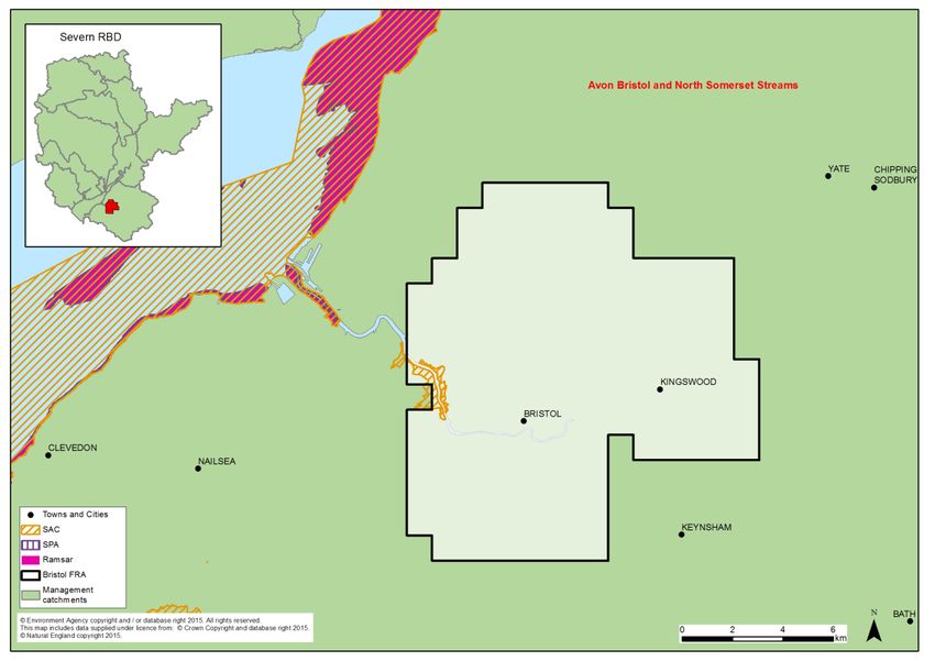
The purpose of the HRA is to report on the likely effects of the FRMP on the network of sites
that are designated for protection (European sites) and the HRA has been carried out at the
level of detail of the plan. Many measures do not have any expected physical effects on the
ground and have been screened out of consideration including most of the measures under
the categories of Prevention, Preparedness, Recovery and Review.
Risk management authorities (RMAs) have for a long time been addressing the range of
flood risks through a range of plans and actions. So, much of the Severn RBD FRMP
presents measures that are ongoing from existing plans which have already been subject to
HRA. RMAs have considered the effects of these existing plan measures on European sites
in published HRAs where required. These measures, their effects and agreed actions to
mitigate the effects have been summarised under relevant RBD catchments and FRAs.
Where RMAs have identified new flood risk management priorities for the next FRMP cycle
period between 2015 and 2021, then the measures to implement these have been
considered alongside existing plan measures in this HRA.
The following summarises the numbers of measures that the HRA has considered for the
management catchments in England and the Bristol flood risk area:
FRMP RMA plans Screened out Measures from New cycle 1
1
measures existing plans measures
Severn RBD catchments (Eng) 295 131 72
FRA Bristol 83 9 0
Total 378 (64%) 140 (24%) 72 (12%)
With respect to the Communities at Risk in Wales, the range of protection measures are
shown below with the number of Communities at Risk they apply to in brackets.
Assess conveyance requirements and implement maintenance (7)
Undertake initial assessment and feasibility work for reducing flood risk (3)
Develop scheme appraisal for Flood Alleviation Scheme (1 )
Design and construction of flood risk asset improvements or alleviation scheme (6)
Carry out an assessment of existing structures to ensure they are fit for purpose (4 )
Implement alternative risk reduction measures (3)
The HRA has been carried out for the set of measures for each RBD catchment that address
main river, sea and reservoir flooding alongside any measures volunteered by RMAs that
address local flooding and thus form a ‘RBD plan’ within the FRMP. Measures within FRAs
that address high risk of local flooding in these areas have been considered in the HRA as
separate ‘FRA plans’ within the FRMP. Both ‘RDB plan’ and ‘FRA plans’ are further
considered in-combination by the HRA. The findings are a summary of the risks to European
sites and an indication of the need for future HRAs at a project level when developing local
actions, as well as considering how to avoid and mitigate any residual risks to European
sites.
For the parts of the Severn RBD FRMP in England, the main conclusions from the
assessment of all RMA plans of the FRMP are as follows:
1
Measures across several catchments are counted up for each catchment for HRA purposes which may be a
different figure than reported in the FRMP.
2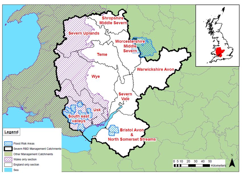
A determination was made to screen out measures that would not have physical effects on
any European sites.
The effects of the measures from existing plans include effects of measures to address
coastal flooding from SMPs, measures to address main river flooding from CFMPs and
measures to address local flooding from local strategies. Existing controls and mitigation
from these plans include: for SMPs, development of estuary strategies, and for CFMPs and
Local Strategies more detailed appraisal and assessment on plans or projects arising out of
the plans to demonstrate meeting the requirements of the Conservation of Habitats and
Species Regulations 2010, as amended (Habitats Regulations).
The effects of the measures that are for new flood risk management priorities for the next
FRMP cycle period of 2015 to 2021 have been considered within this strategic-plan level
HRA as far as they can be assessed at this high level. This HRA considered the range of
mitigation options that may be applicable. It is concluded that the measures are expected to
be able to be avoided or mitigated as part of their development as local actions, and all
measures have been identified as capable of being fully mitigated. It can therefore be
concluded that at the plan level there is sufficient scope for ensuring no likely significant
effects during its implementation. The detail of the controls and mitigation required will be
assessed as part of requirements to meet consents under planning and other consenting
mechanisms as part of a project level HRA, some of which may need to proceed to
appropriate assessment in order to gather the necessary level of detail.
For the Wales parts of the Severn RBD FRMP, the main conclusions from the stages of
assessment for the Communities at Risk within Wales are as follows:
Of the 44 European sites within or linked to the Severn RBD, 27 of the sites were shown
not to have any pathway for effects directly or indirectly from the FRMP measures and
were not considered in the test of likely significant effect.
Of the 17 European sites screened in to the test of likely significant effect, it was
concluded that FRMP measures would have no likely significant effect on 7 of the sites.
In the remaining 10 European sites the FRMP measures contain insufficient detail to
ascertain significant effects and consequently the assessment for these measures have
been deferred to lower tier plans or projects. Environmental Assessment and HRA will be
undertaken of these lower tier plans or projects.
It is therefore concluded that the FRMP is not likely to have a significant effect on European
protected sites and an Appropriate Assessment is not required subject to HRAs being
carried out at the project level as set out above.
The HRA further considers the potential for in-combination effects with other plans and
projects. Given the level of information currently available, the assessment has identified the
plans where the greatest risk of in-combination effects occur, but a detailed assessment can
only be undertaken at the project level when details of location and design are known. Key
external plans to consider for in-combination effects are:
3
Local Plans – plans of local planning authorities to determine consent for proposed
developments including FCRM ‘Protection’ types of development and which require
HRA for developments affecting European sites
Water resource management plans – plans to manage the supply of water to
communities by Water Companies.
River Basin Management Plan – plans that seek to ensure the objectives of water
dependent European sites are maintained.
Marine Plans – plans to manage the sustainable use of marine resources for inshore
areas.
This HRA does not remove the need for HRA at a subsequent level, i.e. lower tier strategies,
plans or projects that implement measures. This plan-level HRA does not give any weight to
subsequent lower-tier plans or projects and their HRA outcomes.
As local actions are developed at a project level and the details of their scope and scale are
known, this may identify additional effects on European sites that have not been assessed
here, or were not appropriate to consider at this spatial scale of plan.
4CONTENTS
1 Introduction .................................................................................................................... 6
1.1 Introducing this report ............................................................................................. 6
1.2 Background to the FRMPs ...................................................................................... 6
1.3 The Severn RBD FRMP .......................................................................................... 7
1.4 Background to Habitats Regulations Assessment ................................................... 9
2 European sites in the Severn RBD ............................................................................... 11
2.1 European sites that could be affected by the FRMP.............................................. 13
2.2 European sites and their status for FRMPs ........................................................... 14
2.3 European sites and their management.................................................................. 16
3 Approach to the HRA ................................................................................................... 17
3.1 Description of the FRMP programmes of measures .............................................. 17
3.2 Screening and Likely Significant Effects................................................................ 18
3.3 Approach to the HRA in England .......................................................................... 19
3.4 Approach to the HRA in Wales ............................................................................. 22
4 Severn River Basin District Catchments HRA .............................................................. 25
4.1 Summary of Measures for England ....................................................................... 25
4.2 Summary of measures for Wales .......................................................................... 28
4.3 Screening and Likely Significant Effects (England) ............................................... 28
4.4 Consideration of results and conclusion (England) ............................................... 56
4.5 Initial screening of FRMP Measures for Communities at Risk (Wales) .................. 59
5 Bristol Flood Risk Area HRA ........................................................................................ 64
5.1 Summary of Measures .......................................................................................... 64
5.2 Screening and Likely Significant Effects................................................................ 65
5.3 Consideration of results and conclusion ................................................................ 67
6 In combination effects with other plans and projects .................................................... 69
6.1 RBD and FRA FRMPs .......................................................................................... 69
6.2 In-combination effects between RBD FRMPs ....................................................... 70
6.3 In-combination effects with external plans ............................................................. 71
7 Conclusion and Future HRAs ....................................................................................... 73
Annex A Table A1 HRA screening table for the FRMP measure categories
Table A2 Management Catchments and European sites in the Severn RBD /
FRMP
Table A3 Mitigation and Control Measures
Annex B Severn RBD European sites
Annex C Test of Likely Significant Effects
Table C1 European site Screening (Wales)
51 Introduction
1.1 Introducing this report
This report sets out the results of a strategic-plan level Habitat Regulations Assessment
(HRA) into the likely significant effects on designated ‘European sites’ of the Flood Risk
Management Plan (FRMP) for the Severn River Basin District published in December 2015.
The HRA report has been prepared by the Environment Agency and Natural Resources
Wales on behalf of the collective Risk Management Authorities (RMAs) that have
responsibilities for information being published within the FRMP and are thus the ‘competent
authorities’ for the HRA of their respective published information, as follows:
Information on flooding from main river, sea and reservoirs being published for the
catchments of the river basin district (RBD) are the responsibility of the Environment
Agency (for English catchments) and Natural Resources Wales (for Welsh
catchments).
Information on flooding from local sources being published for any Flood Risk Areas
(FRA) is the collective responsibility of Lead Local Flood Authorities within the FRA.
In preparing the HRA report the Environment Agency has consulted with Natural England
(for English catchments) and Natural Resource Wales (for Welsh catchments). The Lead
Local Flood Authorities in Flood Risk Areas are ‘competent authorities’ for HRA of their
FRMP information and have agreed that this report will meet their HRA requirements.
FRMPs are new strategic plans for implementing the Flood Risk Regulations 2009 and
existing National Flood and Coastal Erosion Risk Management (FCERM) Strategies for
England and Wales. They have been developed for River Basin Districts (RBDs) and Flood
Risk Areas (FRAs) and draw together information from a range of existing strategies and
plans that are in place and continue to be maintained by Risk Management Authorities. The
HRA has been carried out at the level of detail published in the FRMP and takes into
account HRAs that have already been undertaken for measures in existing plans and at the
level of detail provided by these existing plans. Whilst a HRA at this strategic level cannot
obtain the level of detail necessary for in-depth assessment, the HRA summarises the likely
risks and potential need for controls and mitigation and the range of generic mitigation
options available, which will then proceed through further consideration once measures are
developed as specific local actions. In this way, this high- level HRA will be helpful for future
HRAs that consider the effects on European sites at a project level.
The report describes each of the main stages and results of the FRMP HRA as follows:
Describing the network of European sites within the RBD (chapter 2)
The approach to the HRA (chapter 3)
Screening and assessing likely significant effects (chapters 4,5)
Appropriate assessment, alternative solutions and IROPI (chapters 4,5)
Conclusion and future HRAs (chapter 7)
1.2 Background to the FRMPs
Flood risk management plans (FRMPs) highlight the hazards and risks from rivers, the sea,
surface water, groundwater and reservoirs and set out how risk management authorities,
6such as the Environment Agency, Natural Resources Wales and local authorities will
manage flood risk. They are required by the European Union Floods Directive and the Flood
Risk Regulations 2009. The FRMPs must be reviewed and reissued every six years to
describe progress.
The Environment Agency and Natural Resources Wales is required to prepare flood risk
management plans for all of England and Wales covering flooding from main rivers, the sea
and reservoirs. Lead Local Flood Authorities (county councils and unitary authorities) must
prepare flood risk management plans for flood risk areas (there are ten flood risk areas in
England and eight in Wales) where the risk of flooding from local sources is significant as
identified in Preliminary Risk Assessments.
The 2015-2021 period will be the first cycle of the FRMPs, however RMAs already plan for
flooding and a large proportion of the FRMPs are taken from existing plans that have already
been consulted on and published. This includes plans such as Catchment Flood
Management Plans (CFMPs) and Shoreline Management Plans (SMPs) as well as Local
Flood Risk Management Strategies that have been developed by local authorities.
Some further strategic developments have been included for the 2015-2021 first cycle of the
FRMP that build on existing plans and seek to address the key objectives of the Flood Risk
Regulations 2009 such as: strengthening joint working of RMAs, developing more integrated
management of the water environment, and updated priorities from any new understanding
of flood risks including the implications of climate change.
1.3 The Severn RBD FRMP
The Severn River Basin District (RBD) covers an area of just over 21,500 km2. The River
Severn is the longest river in Britain, stretching 350km from its source to the mouth of the
Bristol Channel. It has a varied landscape from the uplands of Wales, down through valleys
and rolling hills through central England, to the lowlands and the Severn Estuary.
The area is home to more than 5.75 million people, and includes the major urban centres of
Bristol, Cardiff and Coventry. Protected landscapes include the Brecon Beacons National
Park and the Wye Valley Area of Outstanding Natural Beauty (AONB), and two
Environmentally Sensitive Areas (ESAs) in the Upper Wye. A variety of habitats are
internationally protected including the rivers Usk, Clun and Wye and the uplands of the
Berwyn Mountains. The Severn Estuary and its surrounding area are protected for their bird
populations, habitats and migratory fish species.
The FRMP describes the scale of flood risk in the Severn RBD which includes:
Approximately 100,000 people, just under 2% of the population, are at medium to
high risk of flooding from rivers and the sea. Other sources of flooding include that
from reservoirs where 260,000 people, 4.5% of the total population in the RBD, are at
risk of flooding. Approximately 120,000 people, just over 2% of the total population
within the RBD, are at medium to high risk of flooding from surface water sources.
Sewer flooding is also prevalent in the many urban centres located within the district.
The upland areas within the RBD have many watercourses which respond rapidly to
high levels of rainfall as a result of the steep topography. These include the Welsh
7Mountains, the Brecon Beacons, along the Cotswold escarpment, in the Forest of
Dean and Mendip Hills.
Longer more sustained flooding is experienced over a significant area of the district
in the middle to lower lengths of the larger watercourses such as the Rivers Wye,
Severn, Warwickshire Avon and Bristol Avon. Here the topography is much flatter
and the geology comprises of mudstones and clays that have low permeability and
thus can become easily saturated. In these areas many medium to smaller sized
communities are at high flood risk. In addition the groundwater table in these areas is
also normally high contributing to the level of flood risk.
The risk of tidal flooding is most prevalent along the coastlines of Wales and North
Somerset, extending up the River Severn as far as Gloucester. Areas adjacent to the
coast are relatively flat with very little elevation. Many of the areas adjacent to the
coast are provided with a level of protection by defences.
Within the RBD there are many examples of flood defences which reduce the risk of
flooding to major urban areas, local communities, essential infrastructure and
agricultural land. These defences take the form of earth embankments, flood walls,
outfall structures, barrage, attenuation areas, engineered channels and individual
property level protection.
The river has a variety of flooding issues along its length and given the complicated
nature and volume of tributaries there is a need to take a catchment-wide view to all
changes within the RBD. Activities must seek to avoid passing risk on to others within
the catchment without prior agreement.
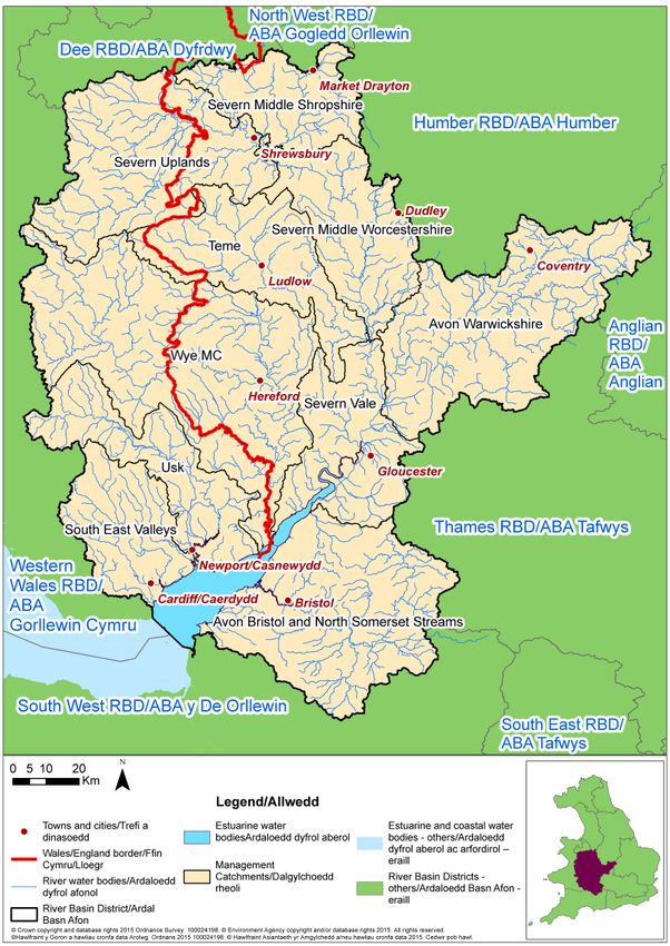
Figure 1: Severn RBD showing Catchments, Flood Risk Areas and Wales and England
only sections
8The Severn FRMP has been produced jointly between the Environment Agency and Natural
Resources Wales as the responsible authorities for flood risk management in England and
Wales respectively. It sets out the objectives and measures to manage flood risk, from the
Environment Agency, Natural Resources Wales and the Lead Local Flood Authorities for the
Severn RBD. The measures have been developed by the Environment Agency, Natural
Resources Wales and the Lead Local Flood Authorities (LLFAs) within the respective RBDs.
Measures within the FRMPs are either already developed, these are derived from existing
plans, which have been separately consulted on and published with accompanying
assessment, including Habitats Regulations Assessment (HRA); or are new measures,
developed specifically for inclusion in the FRMP. The source of the measures has
determined how they have been treated in the HRA.
Existing plan measures in the Severn FRMP are derived from the following source plans:
Catchment Flood Management Plans (CFMPs)
Shoreline Management Plans (SMP)
Local Flood Risk Management Strategies (FRMS) developed by LLFAs
Estuary Flood Risk Management Strategies
Surface Water Management Plans
The measures derived from these plans have already been subject to consultation and
assessment, including HRA. Where measures taken from existing plans have been deemed
to potentially affect European sites, the HRAs of those source plans have been referred to.
The FRMP is divided into the separate plans that are the responsibility of different risk
management authorities, as follows:
RBD catchment measures that the Environment Agency (English parts) and Natural
Resources Wales (Welsh parts) are responsible for,
Measures within the Bristol Flood Risk Area (FRA) for local sources of flooding that
FRA Lead Local Flood Authorities are responsible for.
Measures within the FRAs that are in Wales are being produced as separate FRMPs by the
responsible Lead Local Flood Authorities.
1.4 Background to Habitats Regulations Assessment
In England and Wales, the Conservation of Habitats and Species Regulations 2010, as
amended, commonly termed the Habitats Regulations, implements the European Union
Habitats Directive (Directive (92/43/EEC) on the Conservation of natural habitats and of wild
flora and fauna, and certain elements of the Wild Birds Directive (2009/147/EC). This
legislation provides the legal framework for the protection of habitats and species of
European importance in England and Wales.
Sites protected under the Habitats Regulations comprise Special Protection Areas (SPA),
Special Areas of Conservation (SAC), candidate SACs (cSAC), Sites of Community
Importance (SCI) and, as a matter of government policy, to potential Special Protection
Areas (pSPA) and Ramsar sites (sites designated under the 1971 Ramsar Convention for
their internationally important wetlands). These sites are referred to collectively as in this
report as ‘European sites’.
9Regulation 9(3) of the Habitats Regulations requires that a ‘competent authority’ must
consider the requirements of Habitats Directive in exercising any of its functions. Article 6(3)
of the Habitats Directive defines the requirements for assessment of plans and projects
potentially affecting European sites. This requires that a competent authority, before
deciding to undertake, or give any consent or authorisation for a plan or project which is
likely to have a significant effect on a European site, and is not directly connected with or
necessary to the management of that site, must carry out an appropriate assessment. The
term commonly referred to for the assessment process is ‘Habitats Regulations
Assessment’.
The Severn FRMP is considered to fit within the definitions of a ‘plan’ as defined by the
Habitats Directive, and requires a Habitats Regulations Assessment (HRA). The FRMP is a
high-level planning document for the Severn River Basin District (RBD) (see map in Figure
1), therefore potential impacts of the plan on European sites across the RBD are difficult to
determine. Given the geographic scale and nature of the plan, the HRA needs to be tailored
to be appropriate for the spatial area of coverage and the strategic nature of the plan.
The Habitats Regulations Assessment has followed a framework four distinct stages, only
moving to the next stage if required by the results of that stage of the assessment. The four
stages are:
Stage 1: Screening and Likely Significant Effects is the process which initially identifies
the likely impacts upon a European Site of a project or plan, either alone or in combination
with other projects or plans, and considers whether these impacts may be significant. It is
important to note that the burden of evidence is to show, on the basis of objective
information, that there will be no significant effect; if the effect may be significant, or is not
known, that would trigger the need for an Appropriate Assessment.
Stage 2: Appropriate Assessment is the detailed consideration of the impact on the
integrity of the European Site of the project or plan, either alone or in combination with other
projects or plans, with respect to the site’s conservation objectives and its structure and
function. This is to determine whether there is objective evidence that adverse effects on the
integrity of the site can be excluded. This stage also includes the development of mitigation
measures to avoid or reduce any possible impacts.
Stage 3: Assessment of alternative solutions is the process which examines alternative
ways of achieving the objectives of the project or plan that would avoid adverse impacts on
the integrity of the European Site, should avoidance or mitigation measures be unable to
cancel out adverse effects.
Stage 4: Assessment where no alternative solutions exist and where adverse effects
remain. At Stage 4 an assessment is made with regard to whether or not the development
is necessary for imperative reasons of overriding public interest (IROPI) and, if so, of the
compensatory measures.
102 European sites in the Severn RBD
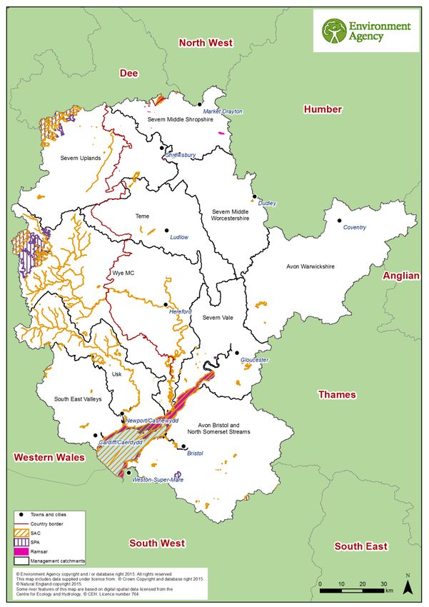
Within the Severn RBD there are 43 SACs, 6 SPAs, and 4 Ramsar sites. Some of the sites
have more than one designation such as the Severn Estuary, parts of which are designated
as SPA, SAC and Ramsar.
Figure 2: Map of the European sites in the Severn River Basin District
11The European sites within the Severn RBD encompass a wide diversity of habitat types. In
addition to freshwater habitats such as rivers, lakes, canals and other wetlands, the RBD
includes sites with estuarine, coastal and marine habitats. Other frequently occurring habitat
types are woodlands, grasslands and heathlands.
Of the 4 Ramsar sites within the RBD the most extensive is the Severn Estuary, which is
also designated as a SPA and SAC. The estuarine and river system of the Severn is one of
the most diverse in the UK for fish species and a key migration route for species, such as
salmon, sea trout, sea and river lamprey, twaite and allis shad and eel, which use the
Severn Estuary to reach spawning grounds in the many tributaries that flow into the estuary
including the Wye and Usk rivers. The site is also an important feeding and nursery ground
for many fish species, particularly allis shad and twaite shad. The immense tidal range of
the Severn Estuary results in extensive areas of intertidal habitats, comprising mudflats,
sandflats, sandbanks, shingle and rocky platforms, together with adjacent areas of saltmarsh
and lowland grazing marsh. These habitats and the food sources they support attract
internationally important assemblages of overwintering and migratory birds, such as gadwall,
dunlin, shelduck, redshank and greater white-fronted goose.
The inland Ramsar sites of the Midland Meres and Mosses occur across the Shropshire,
Cheshire and Staffordshire Plain and are characterised by a complex of lowland open water
and peatland sites that support nationally important flora and fauna. Although much smaller
in size, the Ramsar/SPA of Walmore Common in Gloucestershire supports a variety of
wetland habitats and in winter provides an important refuge and feeding area for wildfowl,
particularly Bewick’s swans. Located within the South West RBD, the Somerset Levels and
Moors SPA/Ramsar site is situated immediately to the south of the Severn RBD border and
is closely associated with the Severn Estuary SPA/SAC/Ramsar site. The site comprises a
series of designated sites that cover extensive areas of flood plain drained by a large
network of ditches, rhynes, drains and rivers. The site represents the largest area of lowland
wet grassland and associated wetland habitat remaining in the UK. The area attracts
internationally important numbers and assemblages of overwintering birds, such as Bewick’s
swan, lapwing and teal as well as representing one of the most important sites in southern
England for breeding waders together with supporting diverse assemblages of aquatic
invertebrates
The SPAs within the RBD and the migratory and breeding bird populations they support are
highly variable. Sites range from the artificial reservoir of Chew Valley Lake near Bristol and
its important overwintering population of northern shoveler, to the extensive upland sites of
Berwyn and Elenydd - Mallaen in Wales and their populations of rare and vulnerable
breeding birds, including merlin, hen harrier and red kite. In addition to the extensive
lowland sites of the Severn Estuary, designated SPAs within the RBD include the open
grasslands of Salisbury Plain and its important overwintering and breeding bird populations
such as hen harrier, stone curlew and quail.
Across the RBD there is a wide variety of SACs. Some sites are designated primarily due to
the species they support, such as the populations of great crested newts at Granllyn in
Wales and Fens Pools in Dudley, the fresh water pearl mussel of the River Clun and the
aquatic plant species (floating water plantain) associated with the Montgomery Canal and
Brown Moss. A number of sites within the RBD are designated for supporting important
populations of bat species, including sites at Bath and Bradford-on-Avon, North Somerset
12and Mendip, Wye Valley and Forest of Dean, Usk, Mells Valley, and Tanat and Vyrnwy.
Other sites are designated for supporting important invertebrate species. This includes the
wet grassland sites of Aberbargoed and Blaen Cynan that support populations of marsh
fritillary butterfly, and the rare invertebrates species, such as the violet click beetle,
associated with ancient tree habitats at Bredon Hill and Dixton Wood. A primary reason for
the designation of the River Wye and Usk SACs is the range of Annex II fish species they
support, including sea, brook and river lamprey, bullhead, twaite shad and Atlantic salmon in
addition to their well established otter populations. In the case of the River Clun SAC, fish
species such as salmon and brown trout are also considered to be a feature of interest due
to their importance in the life cycle of the freshwater pearl mussel.
Many of the sites within the RBD are also designated in respect of their qualifying habitats,
such as riverine habitats of the Wye and the lakes, ponds, mires and bogs of the West
Midlands Mosses. Other qualifying habitats subject to SAC designation include the
woodlands of the Wye Valley and Avon Gorge, the Cardiff and Cotswolds beechwoods, the
alluvial forests associated with Coed y Cerrig, and the oak woods of Sugar Loaf and
Coedydd Llawr-y-Glyn. Other designated habitats represented in the RBD include the chalk
grasslands of Salisbury Plain, the limestone grasslands of the Mendips, and the extensive
Molinina meadows associated with Cwm Cadlan and Drostre Bank. Designated upland
habitats and heathlands are also represented in the Brecon Beacons and Berwyn and South
Clwyd Mountains together with the transitional dry heathland habitats of the Stiperstones
and Hollies. Within the RBD sites designated for their wetland habitats range from the
upland mires of Elenydd to the lowland raised bogs at Fenn’s Whixall, Bettisfield, Wem and
Cadney Mosses and Llangorse Lake, the largest lake in South Wales.
Annex B contains a summary of the European sites present within the management
catchments of the Severn RBD. Table A2 in Annex A presents a summary of the European
sites present within the management catchments. In a number of cases European sites
cross over the boundary of two or more management catchments, therefore a number of
European site names / designations may appear against more than one management
catchment.
2.1 European sites that could be affected by the FRMP
The Severn RBD FRMP is a long term plan for the water environment, which could
potentially affect both water dependent and non-water dependent European sites and their
qualifying features.
Water dependent European sites are classified as protected areas under the WFD; each
protected area European site has specific objectives to ensure their favourable conservation
status. Supporting measures within the Severn River Basin Management Plan (RBMP)
should predominantly be beneficial for the conservation status of water dependent European
sites, and the Severn FRMP seeks to align with the objectives of the Severn RBMP
wherever possible. Where feasible, FRMP measures that also aim to improve water body
status within the Severn RBMP / RBD are identified. Indeed, FRMP measures that seek to
change land use and promote floodplain restoration can serve to improve water quality and
in turn benefit the conservation status of water dependent European sites.
13It is not possible from the outset to rule out, at the RBD scale, any (water-dependent or non
water-dependent) European sites from being affected by the Severn RBD FRMP. This HRA,
in particular section 4 (and sections 5 for the FRA in the Severn RBD), reviews the European
sites by management catchment, and determines whether any of the measures within the
catchments are likely to lead to significant effects on European sites.
2.2 European sites and their status for FRMPs
The Severn RBMP provides summary information on the current status and baseline for
water-dependent European sites as part of its monitoring data.
European sites in England and Wales, with the occasional exception, are also designated as
SSSIs. Natural England and Natural Resources Wales monitor the conditions of SSSIs and
their component units using six reportable condition categories: favourable; unfavourable
recovering; unfavourable no change; unfavourable declining; part destroyed and destroyed.
The current status of water-dependent European site protected areas (in England) for the
Severn RBD is summarised in table 1a below. This gives the current area of water-
dependent SSSI units of European protected areas in different condition categories as
currently recorded on Natural England’s and Natural Resources Wales’s designated site
data system. SSSI units underpin European protected areas and Natural England and
Natural Resources Wales only collects data at a SSSI unit level. When SSSI units are in
favourable condition, they are deemed to be meeting their conservation objectives.
Table 1a: WFD status of water dependent SSSIs for the Severn RBD (England) 2
Condition Severn RBD (ha)
Favourable 11,668
Destroyed / Part destroyed 2
Unfavourable declining 208
Unfavourable no change 337
Unfavourable recovering 1,125
Total Area Unfavourable 1,670
% Unfavourable 13
The table shows that for the Severn RBD, 13% of water-dependent SSSI units of European
protected area sites are currently not compliant with the condition requirements.
In Wales the reporting approach is different; the condition of designated habitats and species
features in SACs / SPAs for the Habitats and Birds Directives cycle (2007-2012) was
reported to the Joint Nature Conservation Committee (JNCC), on a designated habitat or
species feature basis, rather than SSSI unit status. In addition there are slight differences to
some of the categories used for reporting. Table 1b summarises the data for the Welsh
section of the Severn RBD based on the number of designated habitats and species
features in each category. The table indicates that for the parts of the RBD in Wales, over
half of designated habitats and species features are in unfavourable condition.
2 Source Extract from Natural England databases August 2015
14Table 1b: Natura 2000 protected areas current condition for the Severn RBD (Wales)3
Current condition
Number of Natura 2000 habitats and
species
Favourable: Maintained 4
Favourable: Recovered 3
Favourable: Un-classified 9
Unfavourable: Recovering 4
Unfavourable: No change 4
Unfavourable: Declining 1
Unfavourable: Un-classified 34
Destroyed: Partially 0
Destroyed: Completely 0
Not assessed 24
Total 83
The generic pressures on European sites in the Severn RBD include forestry, woodland and
scrub management and agricultural practices such as levels of grazing. These pressures
can affect the condition, quality and diversity of habitats present on a site as well as the
particular species they support. In the Wye Valley Woodlands, for example, the cessation of
traditional management practices such as coppicing and wood pasture is resulting in a loss
of species diversity as the woodland structure and canopy becomes more uniform.
Inappropriate woodland management and scrub control in the West Midlands Mosses is also
serving to adversely affect the characteristic mire habitats as a result of increased shading,
nutrient addition and the drying out of the sensitive wetland features. Pressures associated
with overgrazing can lead to peat erosion as in the Fenn’s, Whixall, Bettisfield, Wem,
Cadney Mosses and also serve to degrade the habitats of qualifying species, such the
terrestrial foraging habitats for the amphibian populations of Fen’s Pool. More generally
changes in land management in areas surrounding a site can also impact qualifying
features, such as Walmore Common where land management changes in neighbouring
areas are affecting feeding and roosting areas used by its overwintering bird populations.
Other pressures typically linked to river and wetland sites, such as the River Wye and River
Clun and the Meres and Mosses of the RBD, include diffuse water pollution and siltation as a
result of surface water runoff from surrounding agricultural areas and areas of clear cut
forestry, hydrological changes arising from abstractions and alterations to the drainage
network, and physical modifications such as weirs presenting barriers to fish migration. The
Severn Estuary is also subject to pressures from commercial and recreational fisheries and
from development impacts both within and adjacent to the Estuary, as for example,
associated with aggregate extraction, energy and residential and industrial developments. In
the case of the Severn Estuary coastal squeeze is identified as a specific pressure. This is
due to the presence of flood defences along the Estuary constraining the natural inland
3
Source Severn RBMP (2015 Update).
15progression of estuarine habitats as sea levels rise, which in turn results in habitat loss with
the consequent impact on the bird and fish species they support.
Invasive non-native species is a commonly identified pressure for a range of sites across the
RBD and include signal crayfish as well as Himalayan balsam, Japanese knotweed,
Azolla(water ferns), sycamore and cherry laurel. Pressures from public access and
disturbance are similarly widespread, although varying in the specific type of impact to the
qualifying features of the sites. For example, disturbance to bat colonies and sensitive cliff
habitats is a particular issue for the Wye Valley Woodlands, whilst for Walmore Common
and the Severn Estuary a key issue is disturbance to and displacement of their overwintering
and migratory bird species. For riverine habitats, such as the River Wye, disturbance to
species and habitats can result from recreational activities such canoeing and angling.
Habitat fragmentation is also an identified pressure for certain sites, such as the West
Midlands Mosses, where the lack of habitat connectivity can hinder re-colonisation and affect
species diversity.
There are also long term national threats to habitats and especially species, including
climate change and alterations in hydrological and coastal processes.
2.3 European sites and their management
As part of a new strategic approach to managing all England’s European sites, new
measures needed to achieve favourable conservation status for all European sites in
England have been developed by Natural England. These are collectively referred to as Site
Improvement Plans (SIPs), and are being developed by the Improvement Programme for
England’s Natura 2000 sites (IPENS). SIPs were published for all European sites in England
in 20154.
In relation to the European sites within the Severn RBD, Site Improvement Plans (SIPs)
developed by Natural England, in conjunction with Natural Resources Wales for sites that
cross the border, include measures and actions for which flood risk management is identified
as the mechanism for their delivery (see section 4.2 for further detail). The SIPs for all
European sites in England were published in or before July 2015. For every European site in
Wales (apart from cross-border sites) Natural Resources Wales are leading on the
development of Prioritised Improvement Plan (PIPs).
The Severn FRMP recognises SIPs include actions where flood risk management is
specifically a mechanism for their delivery. The following are the SIPs and PIPs for Severn
RBD that include actions associated with flood risk management:
River Clun
River Wye
Severn Estuary
River Usk (PIP)
4
Site Improvement Plans for the Severn River Basin District can be found on:
http://publications.naturalengland.org.uk/category/6287197783195648
163 Approach to the HRA
The steps undertaken to complete the HRA are as follows:
describe the plan and the measures proposed
screen and assess the likely significance of any effects on European Sites
consider need for further stages of assessment (i.e. appropriate assessment,
alternative solutions and IROPI)
determine a plan level conclusion
3.1 Description of the FRMP programmes of measures
The Severn RBD FRMP is a joint publication of several plans required under the Flood Risk
Regulations that are the separate responsibilities of specific Risk Management Authorities
(RMAs), as follows:
Severn River Basin District catchments (Environment Agency and Natural Resources
Wales)
Bristol Flood Risk Area (LLFAs within the FRA)
The Severn RBD is cross-border with areas in England and Wales. For those areas of the
RBD in Wales Natural Resources Wales has taken the lead on the HRA, whilst for areas in
England the Environment Agency has taken the lead on the assessment.
The approach to the HRA adopted by the EA and Natural Resources Wales has had to
reflect the different ways the responsible authorities are seeking to deliver against their
FRMP objectives for this first cycle of the plans.
In England, measures to meet FRMP objectives are taken from second generation SMPs,
incomplete actions from the CFMPs, where still relevant, and from existing flood risk
management strategies (that may vary SMP policies in some cases). This first plan also
includes a number of new measures at the community level.
Natural Resources Wales has taken a risk based community approach to prioritise where
best to direct investment and deliver measures to meet FRMP objectives. This is informed
by the strategic framework provided by the CFMPs and second generation SMPs. The risk
based community approach is implemented through Natural Resources Wales’s
Communities at Risk Register. This tool provides an indication of where the most vulnerable
communities at risk of flooding from main rivers and the sea are located across Wales. This
is then used to plan and prioritise investment, targeted at the most at risk communities.
Throughout the HRA process the Environment Agency and Natural Resources Wales have
worked closely to ensure the respective approaches take account of cross-border areas and
European sites.
3.1.1 River Basin District Catchments
FRMPs for the River Basin District (RBD) are being published by the Environment Agency
(for English catchments) and Natural Resources Wales (for Welsh catchments), and jointly in
the case of cross-border RBDs, and are focused on measures principally to address flood
sources from main river, the sea and reservoirs. The measures have been aligned to
17catchments based on the River Basin Management Plans (where they are called
‘management catchments’). In the case of those areas of the Severn RBD within Wales,
Natural Resources Wales has further prioritised its programme of measures according to
communities identified at most risk of flooding.
Production of the FRMPs for the RBDs are the legal duty of the Environment Agency and
Natural Resources Wales. Where any voluntary information on local sources of flooding
within RBD catchments has been provided by LLFAs, these are published by joint
agreement in the RBD FRMP. The Environment Agency and Natural Resources Wales are
also the competent authority under the Habitats Regulations for the RBD FRMPs.
3.1.2 Flood Risk Areas
FRMPs for Flood Risk Areas (FRAs) are being published by the Lead Local Flood
Authorities (LLFAs) where the FRAs lie within their administrative boundaries. Production of
the FRMPs for the FRAs are the legal duty of the respective LLFAs. The LLFAs responsible
for the FRA FRMPs are also the competent authority under the Habitats Regulations.
The Severn RBD includes more than one FRA. The assessment of the Bristol FRA FRMP is
included in this document. The remaining six FRAs are located in Wales, where the LLFAs
have made a commitment to produce separate FRMPs (and HRAs, where required). These
FRMPs are being prepared to the same timescales as the Severn FRMP. These are being
considered by Natural Resources Wales under their statutory duties when submitted.
The Severn RBD contains seven FRAs:
Bristol (Avon Bristol and North Somerset Streams Management Catchment)
Blaenau Gwent
Cardiff
Caerphilly
Rhondda Cynon Taff
Merthyr Tydfil
Torfaen
While a small proportion of the West Midlands FRA overlaps the Severn RBD, it is
predominantly located in the Humber RBD and is therefore addressed in the HRA for that
RBD. The Bristol FRA is covered in a discrete separate HRA section (section 6) within this
report.
3.1.3 Applying HRA
In applying the HRA process, each RMA plan was assessed separately. A final summary of
conclusions and recommendations for future HRAs is provided that also draws on a high-
level summary of the potential for in-combination effects of the FRMP with other key plans.
3.2 Screening and Likely Significant Effects
This first step of the HRA process requires consideration of screening and likely significant
effects of measures on European Sites. As indicated above the detailed approach to the
HRA by the Environment Agency and Natural Resources Wales has been adapted to reflect
the different ways the responsible authorities are seeking to deliver against their FRMP
18objectives. The tasks undertaken to complete this are as follows and set out in more detail
below:
in England, screening out catchments where no European Sites are present and in
Wales screening out communities at risk where no pathways to European Sites are
identified
screening out measures that would not have physical effects
considering measures from existing plans, with mitigation / controls already agreed in
HRAs for any likely significant effects, or in some cases potential adverse effect on
site integrity
considering new measures and their likely significant effects, with mitigation / controls
where considered necessary
conclusion from screening and likely significant effects (Step 1)
The results of these tasks for each RMA’s plan of the FRMP are provided in the following
chapters:
Chapter 4: The Severn River Basin District catchments
o England (4.1)
o Wales (4.5)
Chapter 5: Bristol Flood Risk Area
3.3 Approach to the HRA in England
3.3.1 Screening out catchments where no European Sites are present
Where there are no European sites present in a catchment, it was determined that no further
consideration of measures in the catchment is required. Given the level of detail in the plan
where the FRMP measures are mainly strategic in nature and are not specific on their
precise location, there is insufficient details to consider downstream or down drift effects
beyond the catchment. However, such screening for cross-catchment effects will be a
requirement in assessing local plans and projects.
3.3.2 Screening out measures that would not have physical effects
Every measure included within the FRMP is categorised according to one of the following 4
categories, accompanied by an M-code:
Prevention (M2) - reducing the impacts of flooding through land use and
development policy, relocation of assets at risk, or measures to divert the hazard to
avoid harm.
Protection (M3) - protecting people from the risk of flooding; for example, by the
maintenance, refurbishment of existing defences or building new defences.
Preparedness (M4) - by taking actions that prepare people for flooding; for example,
by improving awareness of flood risk, or by providing warning and forecasting for
floods.
19 Recovery and review (M5) - supporting recovery after flooding has happened and
reviewing how things can be improved; for example, by improving the availability of
recovery services such as providing temporary accommodation.
Other (M6) – measures not fitting in to any of the above categories.
Further definitions of each of the measures are set out in the FRMP according to a second
tier of M-codes. For example, Prevention (M2) includes the second tier measure, M22, which
is defined as “Prevention, removal or relocation measure to remove receptors from flood
prone areas or to relocate receptors to areas of lower risk”. These measure definitions have
been used as the basis for the initial screening out of the measures that require no for further
consideration within the HRA.
The measure codes and their definitions are included as Table A1 (in Annex A to this
document). Measures under ‘Preparedness’ (M4) and ‘Recovery and review’ (M5) will not
result in development, demolition or changes of management ‘on the ground’ that could
result in affects on European Sites. These were therefore screened out from any further
consideration. Similarly, under the ‘Prevention’ category (M2), only the removal or relocation
of receptors from flood prone areas could potentially affect European sites. The measures
that have been screened in to the assessment are set out below and have been highlighted
in Table A1:
M3 – Protection – all sub-categories
And in England, on a precautionary basis:
M22 – Prevention – removal or relocation (category)
M6 – Other – not yet defined.
3.3.3 Considering measures from existing plans
Risk Management Authorities have a range of plans in place for developing and
implementing measures related to flooding from main river (in Catchment Flood
Management Plans) and related to flooding from the sea (in Shoreline Management Plans)
and related to local sources of flooding (e.g. in Local Flood Risk Management Strategies).
These plans have been subject to HRA where relevant, and have reported on the effects on
European sites consistent with the level of detail of the plans.
For this HRA, these existing HRAs have been used to summarise the effects of measures
from existing plans that are now set out under specific RBD catchments or FRAs. For many
RBD catchments and FRAs there are multiple existing plans covering the geographic area
but also some existing plans that are split across RBD catchments or FRAs. Nonetheless the
‘screened in’ measures from individual existing plans were separated out and the HRA
results that apply to them referenced.
The results from existing HRAs have considered the extent that they remain valid since they
were published. This has been done by checking the status of the relevant European sites
that were considered within the source plan’s HRA for any changes to site designations
since the date of the HRA publication. The criteria were agreed with Natural England and
comprised: whether there were any new / additional site designations, any changes in site
boundaries, changes in designated site features, or any significant changes in site
conditions.
20The HRA results from Shoreline Management Plans are relatively recent with most
published between 2010 and 2011. The HRA results from Catchment Flood Management
Plans are a little older with most published between 2008 and 2010. The HRA results from
Local Flood Risk Management Strategies are the most recent with the first ones being
published around 2012 and most being published much more recently.
One of the main reasons for a likely change from when the effects of plan measures were
reported in HRAs is where there have been boundary changes to European sites or to the
scope of condition of the interest features of the sites i.e. specific habitats, species etc.
Where advised that such changes have occurred and are significant then this has triggered
further consideration of the validity of the existing HRA results that were relied upon.
3.3.4 Considering new measures for FRMP cycle 1
In reviewing the range of measure across existing plans covering all sources of flooding,
Risk Management Authorities (RMAs) have taken the opportunity to put forward further
strategic developments for the next 6 year cycle of the FRMP. These ‘new measures’ focus
on: strengthening the joint working of RMAs across all flood sources; developing more
integrated management of the water environment as set out in the River Basin Management
Plans and other related plans; and updating flood risk information to help manage risks with
communities.
For this HRA the set of new measures that have been ‘screened in’ for each catchment has
been reviewed. As they are mostly ‘strategic’ measures without specific information on
location or the form of action that would be developed on the ground, a range of factors that
could give rise to any likely risks from this set of measures in a specific catchment were
considred. These included:
their general proximity in the catchment to European sites
whether they aim to address sources of flooding that are local, or main river or
related to the coast
the mix of types of new measures within the catchment denoted by their M-codes
(i.e. whether they are mainly maintenance, or channel works, or new solutions)
General proximity was considered by narrowing down the set of measures within a
catchment to those that were closer in general and more likely to be connected to European
sites by the hydrology of the catchment rather than applying specific buffer distances to
individual measures.
3.3.5 Considering the need for further stages of assessment
HRA steps were carried out for each RBD catchment of the RBD plan that is the
responsibility of the Environment Agency. Further HRA steps were carried out for each FRA
(by catchment) that is the responsibility of respective Lead Local Flood Authorities. The
determination for each catchment or FRA that there are no likely significant effects to
European sites, is based on the following assumptions:
that this HRA does not remove the need for HRA at a subsequent level, i.e. lower tier
strategies, plans or projects that implement measures, nor does it give any weight to
their outcomes. Consideration of potential impacts and options available to mitigate
21for those impacts should assist, but not influence or constrain any lower-tier
assessments.
that as local actions are developed at a project level and the details of their scope
and scale are known, that this may identify additional effects on European Sites that
have not been assessed here, or were not appropriate to consider at this spatial
scale of plan.
3.4 Approach to the HRA in Wales
3.4.1 Measures assigned nationally in Wales
The Floods Directive identifies that FRMPs and RBMPs are elements of integrated river
basin management and that “the two processes should therefore use the mutual potential for
common synergies and benefits, having regard to the environmental objectives of Directive
2000/60/EC, ensuring efficiency and wise use of resources”.
In support of this principle, Natural Resources Wales have proposed Flood Risk
Management National Measures for the RBMPs & FRMPs:
Identify opportunities to improve the water environment through existing programmes
of work and scheme designs for Flood Risk Management.
Natural Resources Wales will seek opportunities and influence others to utilise
natural flood risk management measures where appropriate.
Implement managed realignment and intertidal habitat creation through the National
Habitat Creation Programme (NHCP).
In water bodies designated as heavily modified due to flood and coastal protection,
mitigation for Natural Resources Wales owned assets and activities will be reviewed
and delivered on a prioritised basis.
Contribute to the achievement of the WFD objective and favourable conservation
status at priority Water Level Management sites.
Contribute to research and development to identify best practice for managing
hydromorphological pressures in the water environment.
These national measures are a commitment by Natural Resources Wales to ensure that
operational flood risk management work is delivering, where possible, benefits for the water
environment. These national measures will influence the proposed measures for each of the
communities at risk and so have been taken into account, where appropriate, in the Test of
Likely Significant Effect.
3.4.2 Measures assigned locally to communities at risk in Wales
Consistent with the approach in England, the FRMP in Wales consists of existing and new
measures in four general areas: Prevention, Protection, Preparedness and Recovery &
Review. The existing measures have been previously consulted on and have approved
HRAs associated with them. These are the policies and actions set out in the second
generation SMPs and CFMPs.
The new measures in the FRMP are focussed on the communities at greatest flood risk in
Wales. The HRA does not revisit the SMP2 or CFMP HRA conclusions as these are still live
22You can also read