Draft Fire Hazard Management Plan - Appendix S EIS Volume 3
←
→
Page content transcription
If your browser does not render page correctly, please read the page content below
EIS Volume 3 Appendix S

Draft Fire Hazard Management
                        Plan
Draft Fire Hazard Management Plan

Contents
1.    Introduction .................................................................................................................. 1
      1.1.    Project Overview..................................................................................................................1
      1.2.    Project Description ..............................................................................................................1
      1.3.    Purpose of the FHMP ...........................................................................................................3
              1.3.1. Objectives of the FHMP ..........................................................................................3
              1.3.2. Scope of the FHMP..................................................................................................4
      1.4.    Report terminology ..............................................................................................................4
      1.5.    Stakeholder Consultation ....................................................................................................5
      1.6.    Relevant Legislation, Planning Controls and Standards ......................................................5
              1.6.1. Development Act 1993 and Development Regulations 2008 .................................5
              1.6.2. Fire and Emergency Services Act 2005 ....................................................................5
              1.6.3. State Bushfire Management Plan ...........................................................................5
              1.6.4. Bushfire Management Area Plans ..........................................................................6
              1.6.5. Bushfire Protection Overlays ..................................................................................6
              1.6.6. Bookmark Mallee Bushfire Management Plan .......................................................9
              1.6.7. Code of Practice for Fire Management on Public Land in South Australia .............9
              1.6.8. South Australian Firebreaks, Fire Access Tracks and Sign Standards Guidelines ...9
              1.6.9. South Australia Electricity (Principles of Vegetation Clearance) Regulations 2010
                       ............................................................................................................................. 11
              1.6.10. National Electricity Network Safety Code ............................................................ 11
              1.6.11. Overall Fuel Hazard Guide for South Australia .................................................... 11
              1.6.12. AS 3959 Construction of buildings in bushfire prone areas................................. 12
              1.6.13. Other Acts and Regulations ................................................................................. 12
      1.7.    ElectraNet Bushfire Risk Management Guideline ............................................................ 13
2.    Assets.......................................................................................................................... 14
      2.1.    On-site assets .................................................................................................................... 14
              2.1.1. Existing Robertstown substation ......................................................................... 14
              2.1.2. New Bundey substation ....................................................................................... 14
              2.1.3. Transmission lines ................................................................................................ 15
              2.1.4. Telecommunications infrastructure .................................................................... 16
              2.1.5. Access tracks ........................................................................................................ 16
              2.1.6. Temporary construction camps ........................................................................... 17
              2.1.7. Laydown and staging areas .................................................................................. 17
      2.2.    Surrounding Assets ........................................................................................................... 19
              2.2.1. Life and property assets ....................................................................................... 19
              2.2.2. Environmental assets ........................................................................................... 19
3.    Local Bushfire Environment ........................................................................................ 21
      3.1.    Bushfire History ................................................................................................................ 21
      3.2.    Potential Ignition Sources ................................................................................................. 21
              3.2.1. Ignition during construction ................................................................................ 21
              3.2.2. Ignition during operation ..................................................................................... 21
              3.2.3. External sources of ignition ................................................................................. 22

Project EnergyConnect
Environmental Impact Statement                                                                                                                        i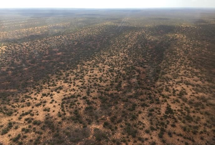
Draft Fire Hazard Management Plan

      3.3.    Vegetation and Topography ............................................................................................. 24
              3.3.1. Vegetation............................................................................................................ 24
              3.3.2. Topography and slope under vegetation ............................................................. 27
      3.4.    Predominant and Worst-case Bushfire Weather Conditions ........................................... 31
              3.4.1. Climate statistics .................................................................................................. 31
              3.4.2. Predominant bushfire weather conditions .......................................................... 32
              3.4.3. Worst case bushfire weather conditions ............................................................. 33
4.    Potential Bushfire Risk Scenarios................................................................................ 35
              4.1.1. Scenario 1: Bushfire risk to the Project as a result of a bushfire occurring within
                     the surrounding landscape .................................................................................. 35
              4.1.2. Scenario 2: Bushfire risk to the Project as a result of construction or operation
                     activities ............................................................................................................... 36
              4.1.3. Scenario 3: Bushfire risk to surrounding life, property and environmental assets
                     as a result of construction or operation activities ............................................... 36
5.    Bushfire Risk Assessment ........................................................................................... 38
      5.1.    Assessment of Potential Bushfire Scenarios ..................................................................... 38
      5.2.    Bushfire Risk Assessment Methodology ........................................................................... 38
              5.2.1. Risk assessment ................................................................................................... 39
      5.3.    Bushfire Risk Assessment Results ..................................................................................... 41
6.    Recommended Bushfire Risk Mitigation and Management Measures ....................... 44
      6.1.    Prevention......................................................................................................................... 44
              6.1.1. Vegetation management ..................................................................................... 44
              6.1.2. Bushfire construction standards .......................................................................... 45
              6.1.3. Asset inspections and maintenance .................................................................... 46
              6.1.4. Investigations into network events ..................................................................... 46
              6.1.5. Bushfire season controls ...................................................................................... 46
              6.1.6. Promotion of public awareness ........................................................................... 46
              6.1.7. Security ................................................................................................................ 46
      6.2.    Preparedness .................................................................................................................... 47
              6.2.1. Access provisions ................................................................................................. 47
              6.2.2. Development of bushfire emergency evacuation procedures ............................ 47
              6.2.3. Development of other procedures ...................................................................... 48
              6.2.4. Personnel training ................................................................................................ 51
              6.2.5. Routine maintenance and testing ........................................................................ 51
              6.2.6. Pre bushfire season audits ................................................................................... 51
      6.3.    Response ........................................................................................................................... 51
              6.3.1. Fire brigade support............................................................................................. 51
              6.3.2. On-site firefighting resources .............................................................................. 52
              6.3.3. Understanding of bushfire behaviour .................................................................. 52
      6.4.    Recovery ........................................................................................................................... 53
7.    Implementation of FHMP ........................................................................................... 54
      7.1.    Works Program ................................................................................................................. 54
      7.2.    FHMP Monitoring and Review .......................................................................................... 54
8.    References .................................................................................................................. 55

Project EnergyConnect
Environmental Impact Statement                                                                                                                     ii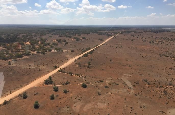
Draft Fire Hazard Management Plan
List of Tables
Figure 1-1:Proposed Project location ............................................................................................2
Figure 1-2: Hazards (Bushfire) Overlays in the Planning and Design Code ....................................8
Figure 2-1: Typical substation components ................................................................................ 15
Figure 2-2: Electricity (Principles of Vegetation Clearance) Regulations 2010 requirements .... 16
Figure 2-3: Typical arrangement of transmission line access tracks (Associated temporary
facilities ............................................................................................................................. 17
Figure 2-4: Existing access roads / tracks and settlements in the Project area .......................... 18
Figure 2-5: Environmental assets in the area of the Project....................................................... 20
Figure 3-1: Bushfire history in the area of the Project................................................................ 23
Figure 3-2: Vegetation classification under AS 3959 .................................................................. 29
Figure 3-3: Topography in the area of the Project ...................................................................... 30
Figure 3-4: Mean monthly rainfall .............................................................................................. 31
Figure 3-5: Mean maximum monthly temperature .................................................................... 32
Figure 3-6: January wind roses Renmark and Eudunda .............................................................. 33
Figure 3-7: Fire seasons (BOM 2021) .......................................................................................... 34
Figure 5-1: Risk management process (SA 2018b) ...................................................................... 39
List of Figures
Figure 1-1:Proposed Project location ............................................................................................2
Figure 1-2: Hazards (Bushfire) Overlays in the Planning and Design Code ....................................8
Figure 2-1: Typical substation components ................................................................................ 15
Figure 2-2: Electricity (Principles of Vegetation Clearance) Regulations 2010 requirements .... 16
Figure 2-3: Typical arrangement of transmission line access tracks (Associated temporary
facilities ............................................................................................................................. 17
Figure 2-4: Existing access roads / tracks and settlements in the Project area .......................... 18
Figure 2-5: Environmental assets in the area of the Project....................................................... 20
Figure 3-1: Bushfire history in the area of the Project................................................................ 23
Figure 3-2: Vegetation classification under AS 3959 .................................................................. 29
Figure 3-3: Topography in the area of the Project ...................................................................... 30
Figure 3-4: Mean monthly rainfall .............................................................................................. 31
Figure 3-5: Mean maximum monthly temperature .................................................................... 32
Figure 3-6: January wind roses Renmark and Eudunda .............................................................. 33
Figure 3-7: Fire seasons (BOM 2021) .......................................................................................... 34
Figure 5-1: Risk management process (SA 2018b) ...................................................................... 39
List of Plates
Plate 2-1: Existing Robertstown substation ................................................................................ 14
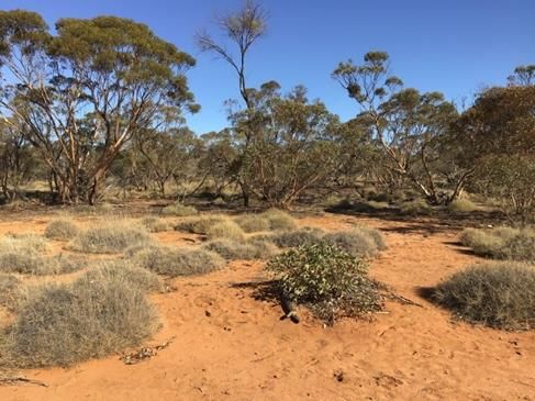
Plate 3-1: Vegetation types along the transmission line corridor .............................................. 26
Plate 3-2: Gently undulating dunes to the north of Monash (centre/east of alignment) .......... 27
Plate 3-3: Plains near Chowilla (east of alignment) .................................................................... 28
Plate 3-4: Undulating hills to the north of the Robertstown Substation (west of alignment) ... 28
Project EnergyConnect
Environmental Impact Statement iii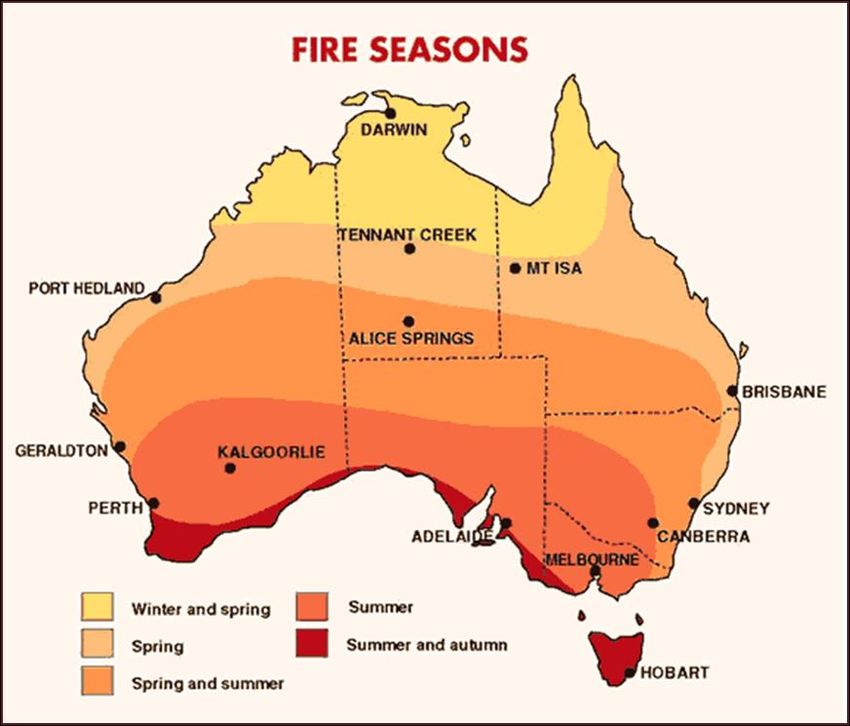
Draft Fire Hazard Management Plan

Executive Summary
ElectraNet is proposing to construct the South Australian portion of Project EnergyConnect (the
Project) which will involve the establishment of a transmission line to connect the power grids of South
Australia and New South Wales with an added connection to Victoria.
This Fire Hazard Management Plan (FHMP) has been prepared to provide overarching guidance to
manage and mitigate potential bushfire impacts to life, property and environmental assets during both
construction and operation of the Project. Site / stage specific Bushfire Management Plans will be
prepared at the relevant stages of development in consideration of the principles and mitigation
measures documented within this Plan.
This FHMP considers the potential impacts of bushfire occurring within the broader landscape
surrounding the Project, as well as bushfire ignited by construction and / or operational activities on
Project assets.
The bushfire risk assessment methodology is based on Australian and New Zealand Standard AS/NZS
ISO 31000:2018 Risk Management–Principles and Guidelines and has been tailored towards assessing
and mitigating bushfire risk. This Plan also considers requirements of relevant SA and federal
legislation and codes relating to bushfire management, environmental protection, and electricity
network safety.
Results of the bushfire risk assessment indicate that the bushfire scenarios assessed pose a significant
level of inherent risk to life, property and environmental assets with Extreme and High levels of
inherent risk being identified. Following implementation of the recommended mitigation measures,
the residual risk is expected to be reduced to lower levels of Low and Medium. Inherent and residual
risk was identified as being higher during the construction stage, where construction activities have a
greater potential to ignite a fire, compared to the operational stage of the Project.
The mitigation measures recommended to manage bushfire risk associated with construction and
operation of the Project have been structured using the universally recognised Prevention,
Preparedness, Response, Recovery (PPRR) framework in order to provide a holistic approach to
bushfire hazard mitigation and management. The recommended mitigation measures include
vegetation management adjacent to life and property assets, adoption of bushfire construction
standards for habitable buildings, asset inspections and maintenance, Total Fire Ban controls, pre-
emptive de-energisation of the power network, promotion of public awareness, suitable access,
development of bushfire emergency evacuation, bushfire monitoring and communication procedures,
training of personnel, pre-bushfire season audits direct firefighting response and continual review of
bushfire risk management measures in place.

Project EnergyConnect
Environmental Impact Statement                                                                        iv
Draft Fire Hazard Management Plan

1.          Introduction
1.1.        Project Overview
Project EnergyConnect involves the proposed construction and operation of a new High Voltage (HV)
electricity transmission interconnector between Robertstown in South Australia (SA) and Wagga
Wagga in New South Wales (NSW), with an added connection from Buronga in NSW to Red Cliffs in
northwest Victoria.
This Fire Hazard Management Plan (FHMP) has been prepared on behalf of ElectraNet, who is the
proponent for the SA section of Project EnergyConnect (the Project), which will extend from
Robertstown in the west to the SA / NSW border in the east.

1.2.        Project Description
ElectraNet is seeking approval under Section 46 of the Development Act 1993 to construct and operate
the Project, which has been declared a Major Development under the Act. The State Planning
Commission (SPC) has determined that the proposal will be subject to the process of an Environmental
Impact Statement (EIS).
A Referral for the proposal was submitted to the then Commonwealth Department of the
Environment and Energy in accordance with the Environment Protection and Biodiversity Conservation
Act 1999 (EPBC Act). The Commonwealth has determined that the proposal is a controlled action and
requires assessment and approval under the EPBC Act because the Project was considered likely to
have significant impact on Matters of National Environmental Significant (MNES).
The Project is proposed to extend approximately 205 km between Robertstown and the SA/NSW
border as shown in Figure 1-1. A 1 km wide transmission line corridor has been nominated and the
final alignment and easement of the transmission line will be confirmed during detailed design. The
Project traverses the local government areas of Regional Council of Goyder, Mid Murray Council,
District Council of Loxton Waikerie, Berri Barmera Council, Renmark Paringa Council and Land Not
Within a Council Area (Pastoral Unincorporated Areas and the Unincorporated Riverland Areas).
The Project comprises:
     •   a new substation located at Bundey, towards the western extent of the transmission line,
         approximately 14 km north east of Robertstown, that will facilitate the increase in voltage
         required from the existing system (from 275 kV to 330 kV) and control the flow between the
         two systems.
     •   approximately 10 km of 275 kV overhead transmission line supported by steel lattice towers
         from the existing Robertstown substation to the proposed new Bundey substation
     •   approximately 195 km of 330 kV transmission line supported by steel lattice towers from the
         new Bundey substation to the SA / NSW border at the interface point with TransGrid's NSW
         portion of Project EnergyConnect.
     •   associated telecommunications infrastructure for operation of the transmission line
         comprising overhead optical ground wires linked by radio towers (one in SA)
     •   associated access tracks to provide access to tower sites for construction and maintenance
         of the transmission line
     •   associated temporary facilities (i.e. construction compounds, site offices, laydown areas,
         mobile concrete batching plants, helicopter staging sites, and temporary construction
         camps).

The above listed proposed Project assets are discussed further in Section 2.1.

Project EnergyConnect                                                                                 1
Environmental Impact Statement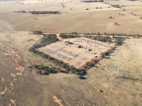
New South Wales
      !
      (
Robertstown
                                                            !
                                                            (      !
                                                                   (
                                                          Morgan Cadell

                                                                                                                                                                                                      South Australia
                                                                                                                                                           !
                                                                                                                                                           (
                                                                                                                                                        Cooltong

                                                                                                                                                                   !
                                                                                                                                                                   (
                                                                                               !
                                                                                               (                                                                Renmark

                                                                                                                                                                                               Victoria
                                                                                           Waikerie
                                                                                                      River Murray
                                                                                                                              !
                                                                                                                              (
                                                                                                                         Barmera
                                                                                                                                                    !
                                                                                                                                                    (
                                                                                                                                                Berri

  Robertstown substation                                          Proposed Bundey substation

                                                                                                                           Port Pirie                                                    NSW
                                                                                                                                                           SA

                                                                                                                                        Clare

                                                                                                                              Port
                                                                                                                              Wakefield                                        Renmark

                                                                                                                                                                           Loxton

                                                                                                                                                                                         VIC
                                                                                                                                         Adelaide
                                                                                                                                        !
                                                                                                                                        (

                                                                                                                                                                                                              ±
   Transmission line corridor              River Murray
                                                                                                                                                           0                             20
   Existing Robertstown substation
   Proposed Bundey substation                                                                                Figure 1-1                                                Kilometres
   Proposed alignment - 275 kV                                                                        Proposed Project location
   Proposed alignment - 330 kV
   Existing ElectraNet transmission line
Draft Fire Hazard Management Plan

1.3.         Purpose of the FHMP
This FHMP has been prepared by JBS&G on behalf of ElectraNet and forms part of the EIS prepared
for the Project.
The FHMP has been prepared in accordance with requirements of the EIS Guidelines which were
issued by the State Planning Commission (SPC) on 20 November 2019. Table 1-1 lists the EIS Guidelines
and requirements relating to bushfire management which have been addressed in this document.
Table 1-1: EIS Guidelines related to bushfire risk management
 Assessment requirement
 General Requirement
 A fire hazard management plan that considers requirements both during the construction and operational phases -
 including measures to minimise fire risk at and to/from the site, resources and training required, sources of water to
 fight fires (and how this water will be accessed), options to utilise and coordinate with other operations in the
 region/area, and cost recovery.
 Effect on Native Vegetation
 Assessment Requirement 4: The proposed development traverses significant stands of native vegetation
 •   4.7 - Identify the potential impact of fire on native vegetation, and the effects of fire risk management processes
     during both construction and maintenance.
 Effect on Native Fauna
 Assessment Requirement 5: The proposed development traverses habitat that supports significant populations of native
 fauna
 •   5.7 - Identify the potential impact of fire on native fauna, and the effects of fire risk management processes during
     both construction and maintenance.
 Hazard Risk
 Assessment Requirement 10: The construction and operation of a high voltage powerline involves a range general and
 specific risks.
 •   10.1 - Evaluate the fire risk of power line and construction/maintenance equipment/vehicles and timing of
     maintenance to avoid fire danger season.
 •   10.2 - Evaluate the risk to electricity supply and infrastructure from fires, lightning, flooding, winds, sabotage etc.

1.3.1.       Objectives of the FHMP
The aim of this FHMP is to identify and adopt best practice and emergency response management
procedures and mitigating actions throughout the life of the Project, including during construction, to
reduce potential risk to life, property and environmental assets. The FHMP also provides an overview
of bushfire risk mitigation and emergency management strategies that should be considered and
adopted at future stages of the Project.
These bushfire risk mitigation measures have been developed based on the Prevention, Preparedness,
Response, Recovery (PPRR) framework to provide a holistic approach to reducing the likelihood of a
bushfire occurring and the consequences for proposed Project assets and the surrounding landscape.
The specific objectives of this FHMP are to:
     •   review legislation, standards, planning controls and regional Bushfire Management Plans
         applicable to the proposed Project
     •   review existing ElectraNet bushfire risk mitigation procedures
     •   identify potential bushfire hazards and scenarios that could impact the Project, as well as
         surrounding life, property and environmental assets

Project EnergyConnect                                                                                                          3
Environmental Impact Statement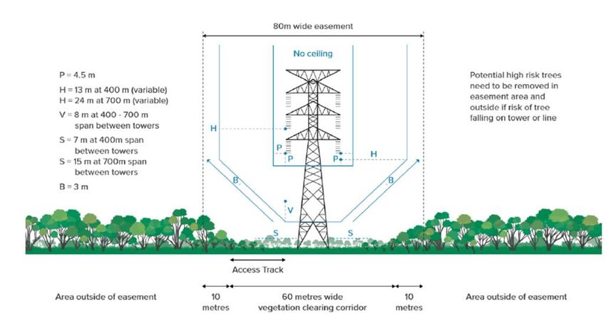
Draft Fire Hazard Management Plan

    •    assess the inherent and residual bushfire risk to life, property and environmental assets both
         during the construction and operational phases of the Project through a risk-based
         assessment
    •    document bushfire risk mitigation measures to minimise risk of bushfire to and from the
         proposal and / or surrounding areas both during the construction and operational phases of
         the Project.

1.3.2.      Scope of the FHMP
This FHMP is a high-level document that has a broad scope and provides an overview of the bushfire
hazards and risks across an area to determine wider impacts irrespective of land tenure and
ownership.
ElectraNet acknowledges the potential risk of bushfire to contractors and staff and the importance of
their safety during construction. The lives and communities, property, and ecological values
surrounding the Project are respected and valued and ElectraNet is acutely aware of its responsibilities
and of the potential risk of construction and operational activities starting a bushfire and the impact
on these values.
The scope of this FHMP encompasses the easement area of the transmission alignment and potential
sites for the substation and temporary facilities, as well as the broader vegetation extent, to ensure
the full scale of bushfire risk to on-site and off-site personnel, property and environment assets is
assessed and managed accordingly.
This FHMP has been prepared primarily to assess the potential bushfire risk to the life, property and
environmental assets listed below:
    •    Life assets:
         o construction and operational workforces
         o adjacent communities.
    •    Property assets:
         o ElectraNet infrastructure, sub-stations, laydowns and temporary facilities
         o adjacent private properties and settlements.
    •    Environmental assets:
    •    Vegetation associated with the Riverland Biosphere Reserve, including Calperum and
         Taylorville Pastoral Lease Scientific Reserves, Chowilla Regional Reserve and Game Reserve
         and various other adjacent Reserves, Conservation Parks and National Parks
         o RAMSAR wetlands
         o River Murray.
This is an initial overarching FHMP consisting of high-level bushfire mitigation strategies and provides
guidance for the preparation of future Bushfire Management Plans at the relevant stage/s of
development (be it construction or operational).

1.4.        Report terminology
The following terms are used within this plan and are defined as:
    •    Project area – the South Australian portion of Project EnergyConnect, between Robertstown
         and the SA/NSW border, including the proposed transmission lines, substation and
         temporary facilities.
    •    Transmission line corridor – the 1 km wide corridor in which the final 80 m wide easement
         and transmission line is expected to be located.

Project EnergyConnect                                                                                 4
Environmental Impact Statement
Draft Fire Hazard Management Plan

1.5.        Stakeholder Consultation
Extensive stakeholder and community consultation has been undertaken for the Project including
targeted engagement with the community, special interest environment groups and traditional owner
representatives to determine the optimal alignment for the Project.
Community engagement has been supported by the establishment of a dedicated website and social
media page (Facebook), a newsletter (the Connector) and the attendance by key project team
members at community field days. Interactive iPads have also been stationed in council offices
allowing members of the community to provide feedback on the project.
Engagement has extended to all councils along the proposed route and engagement is ongoing. CFS
Region 3 was also consulted early to identify key concerns and opportunities for the proposed route
alignment.
To support the release of the EIS, an online engagement room has been established to enable ease of
community and stakeholder feedback. The engagement room provides important information on the
Project, facts sheets which can be downloaded and points to collect feedback from site visitors.

1.6.        Relevant Legislation, Planning Controls and Standards
This section summarises the relevant legislation, policy, planning controls, standards and guidance
documents that are relevant to preparing this bushfire risk assessment report.

1.6.1.      Development Act 1993 and Development Regulations 2008
The proposed development has been assessed as a Major Development pursuant to Section 46 of the
Development Act 1993 (the Act). An Environmental Impact Statement (EIS) has been prepared in
accordance with Section 46B of the Act.

1.6.2.      Fire and Emergency Services Act 2005
The Fire and Emergency Services Act 2005 (FES Act) establishes the SA Fire and Emergency Services
Commission and provides for the metropolitan and country fire and emergency services as well as the
State Emergency Service.
The FES Act outlines the governance, structure and areas of responsibility including for the SA Country
Fire Service (CFS), which maintains responsibility for the Project area, including:
    •    establishment and function of the State Bushfire Coordination Committee and Bushfire
         Management Committees
    •    State Bushfire Management Plans and Bushfire Management Area Plans
    •    fire prevention (fire danger season, total fire bans and permits to burn)
    •    duties relating to fires and emergencies.

Part 4A, Division 3 of the FES Act sets out the requirement for bushfire fuels to be managed on both
private and public land to prevent or inhibit the outbreak and spread of fire, protect property and
minimise the threat to human lives. The FES Act also provides for declaration of fire danger seasons
and total fire ban restrictions which must be adhered to by Project operations (Part 4, Division 8,
Subdivisions 1 and 2).

1.6.3.      State Bushfire Management Plan
The State Bushfire Management Plan (SBMP) identifies the major bushfire risks in the State and
recommends appropriate action that will provide protection to life, property and the environment
from the effects of bushfire. The SBMP sets out principles, policies and standards for bushfire

Project EnergyConnect                                                                                5
Environmental Impact Statement
Draft Fire Hazard Management Plan
management in the State from a high level or strategic perspective, including a strategic approach to
hazard reduction, and strategies for state-wide coordination and integration of bushfire management
activities.
1.6.4. Bushfire Management Area Plans
South Australia is divided into nine Bushfire Management Areas for which a Bushfire Management
Area Plan (BMAP) has been developed as part of a project funded by the Natural Disaster Resilience
Program in partnership with the Commonwealth and State Governments.
The majority of the Project is located within the Murray Mallee (MURRM) BMAP area while the
western portion near Robertstown is located within the Flinders Mid-North Yorke BMAP area.
Each BMAP contains a risk assessment in respect of human settlement, economic, cultural heritage
and environmental assets and consists of a spatial on-line map, an explanatory text document (the
plan) and risk treatment registers for specific assets. BMAPs also identify Bushfire Safer Places and
Last Resort Refuges within the BMA. The purpose of each BMAP is to:
• identify assets as risk from bushfire.
• outline bushfire prevention and mitigation strategies.
• identify responsibilities for implementation of risk mitigation treatments.
• establish principles and standard to guide the success of the bushfire management
strategies.
Bushfire Management Zones are identified within each BMAP to designate areas where fuel
management activities are regularly undertaken with the aim of reducing the risk and impacts of
bushfire on life, property and environmental assets identified in the risk register. The three bushfire
management zones are:
• asset Protection Zones (A-zones).
• bushfire Buffer Zones (B-zones).
• conservation Zones (C-zones).
Asset Protection Zones should be maintained on an annual basis to ensure that the Overall Fuel Hazard
levels are reduced to a level of Moderate or below throughout the fire season. The Native Vegetation
Act 1991 allows for the clearing of understorey vegetation up to 20 m around a residence and can be
extended in response to down slopes and higher vegetation classifications to achieve Bushfire Attack
Level (BAL) 12.5 in accordance with AS 3959 methodology (refer Section 1.6.12). Maintaining BAL-12.5
(Draft Fire Hazard Management Plan Regional and Medium Risk. The Medium Risk areas in relation to the transmission line corridor are primarily located south of Hawks Nest Station and in the Cooltong area (refer Figure 1-2). The development controls in place provide guidance as to how bushfire risk should be considered / addressed on such land. The Code bushfire policies are very similar across all the overlays. Attachment 1 contains an extract of the bushfire overlay Code policy that applies to the transmission line corridor. The overlay policy seeks to ensure that development considers the level of bushfire risk, including the increased frequency and intensity of bushfires as a result of climate change. The location of structures, such as electricity towers, should ensure the threat and impact of bushfires on life and property is minimised as much as possible, and ensures appropriate access for emergency service vehicles. Project EnergyConnect 7 Environmental Impact Statement
New South Wales
               Proposed Bundey substation
                             &

                             !
                             (

           !
           (
   Robertstown
                                                                                    !
                                                                                    (   !
                                                                                        (
                                                                               Morgan Cadell

                                                                                                                                                                                                   South Australia
                                                                                                                                                                   !
                                                                                                                                                                   (
                                                                                                                                                                   Cooltong

                                                                                                                                                                          !
                                                                                                                                                                          (
                                                                                                          !
                                                                                                          (                                                            Renmark

                                                                                                                                                                                            Victoria
                                                                                                       Waikerie
                                                                                                                       River Murray
                                                                                                                                              !
                                                                                                                                              (
                                                                                                                                           Barmera
                                                                                                                                                        !
                                                                                                                                                        (
                                                                                                                                                       Berri

                                                                                                                                                                                                      ±
Planning and Development Code Overlay (Bushfire Hazards)       Transmission line corridor
                                                                                                                                                               0                       20
        Hazards (Bushfire - General)                           Cultural heritage avoidance alignment
        Hazards (Bushfire - High Risk)                                                                                       Figure 1-2
                                                               Existing ElectraNet transmission line                                                                      Kilometres
        Hazards (Bushfire - Medium Risk)
                                                               River Murray
                                                                                                                  Hazards (Bushfire) Overlays in the
        Hazards (Bushfire - Outback)
        Hazards (Bushfire - Regional)                      !
                                                           (   Proposed Bundey substation                            Planning and Design Code
        Hazards (Bushfire - Urban Interface)
Draft Fire Hazard Management Plan
1.6.6. Bookmark Mallee Bushfire Management Plan
A large proportion of the proposed alignment runs within / adjacent to the Riverland Biosphere
Reserve (previously known as the Bookmark Biosphere Reserve), which includes Calperum and
Taylorville Stations. This reserve has significance due to the extensive area of intact mallee vegetation,
as well as the presence of threatened bird species and their habitats, including wetlands and is
protected by a Native Vegetation Heritage Agreement by the State.
The Bookmark Mallee Bushfire Management Plan (BMBMP; DEH 2009) has been prepared to guide
bushfire management measures, including suppression with an emphasis on the protection of life and
property as well as protection of natural and cultural heritage values.
The main objectives of the BMBMP are to:
• protect life and property on all reserves
• restrict the extent of non-prescribed fire in order to protect and maintain mallee habitat as
much as possible for the conservation of threatened species
• contain bushfires within single fire management blocks wherever possible, and to prevent
fire spreading beyond the reserve
• minimise the impacts of both bushfire suppression and pre-suppression works on the
through better incident management, planning and targeted rehabilitation
• monitor the effects of fire on mallee ecosystems
• facilitate a better understanding of the role of fire and its impacts in mallee ecosystems, and
the efficacy of prescription burning in mitigating the threat that bushfire presents through
targeted research and monitoring programs
• protect Cultural Heritage sites from fire
• bushfire mitigation measures proposed within this FHMP aim to align with objectives of the
BMBMP, especially in relation to preventing uncontrolled large-scale fires that have
potential to cause adverse ecological impacts on the Reserve.
The proposed route has been aligned to follow and be within the fire management (B) zone around
the south- eastern and southern boundary of Calperum (northern boundary of Cooltong Conservation
Park). The proposed alignment along the southern boundary of Calperum, the southern and western
boundary of Hawks Nest and the southern boundary of Taylorville presents an opportunity to extend
the fire management zone linking and improving fire access and therefore protection of the Riverland
townships. Further discussion will be undertaken with the CFS and DEW as the project progresses.
1.6.7. Code of Practice for Fire Management on Public Land in South Australia
The Code of Practice for Fire Management on Public Land in South Australia (the Code; GoSA 2018)
provides a framework for fire management on public land in order to reduce the occurrence, severity
and impacts of bushfires on life, property and the environment and promote improved ecological and
biodiversity outcomes using the PPRR framework.
The Code applies to all public land managed by the CFS, Department for Environment and Water
(DEW), ForestrySA and SA Water. As the Project extends through land under management by DEW,
ElectraNet will be required to adopt the Code as part of its bushfire management measures in
accordance with Agency requirements.
1.6.8. South Australian Firebreaks, Fire Access Tracks and Sign Standards Guidelines
The South Australian Firebreaks, Fire Access Tracks and Sign Standards Guidelines (CFS 2018) guides
government agencies to achieve a consistent approach in the establishment and maintenance of
Project EnergyConnect 9
Environmental Impact StatementDraft Fire Hazard Management Plan
firebreaks and tracks used for fire access. The document also aims to provide a guide for private
landholders.
The guidelines state that:
• Firebreaks are an area or strip of land where vegetation has been removed or modified to
reduce the risk of fires starting and reduce the intensity and rate of spread of fires that may
occur; and
• Fire access tracks are tracks used for fire access that are designed, constructed and
maintained for the safe passage of fire fighting vehicles undertaking fire suppression
activities. All designated tracks will permit access by standard 34 units (4WD vehicles
capable of carrying up to 3,500 litres).
The following guidance is provided for firebreaks and fire access tracks:
• Firebreaks and fire access tracks should complement any existing or planned firebreaks or
tracks on adjoining lands specified in Regional and District Bushfire Prevention Plans.
• Wherever possible, firebreaks and fire access tracks should be established on previously
cleared land to minimise the impact on native vegetation and reduce establishment and
maintenance costs.
• Firebreaks should be strategically placed to aid in the protection of fixed assets including
dwellings and other building.
• Firebreaks and fire access tracks should be positioned to aid fire suppression and should be
as straight as practicable.
• As firebreaks normally include access tracks, ease of vehicle access in difficult terrain needs
to be considered.
• Firebreaks should, where practicable, be located in vegetation of least fuel load to improve
the chance of fire control.
• The range of firebreak treatments can extend from total removal to partial modification of
components of its vegetation, leaving trees and only reducing the understorey and fine litter
fuel may achieve a significant reduction in fire intensity while retaining some vegetation to
maintain soil stability and aesthetic value.
A summary of technical requirements for firebreaks and fire access tracks under the Guidelines is
provided in Table 1-2. ElectraNet will liaise with CFS at the detailed design stage to ensure that the
proposed access tracks meet CFS requirements. It is not proposed that the transmission line easement
act as a firebreak, rather the easement access track can be established and maintained to CFS access
requirements.
Table 1-2: Firebreak and access track requirements (CFS 2018)
Technical Requirements
Firebreaks
General Where practicable and environmentally acceptable, a firebreak should
incorporate a fuel-free strip of a minimum width of 1.8 metres
Grassland firebreaks • 4 to 10 m width, including a track used for fire access.
• In native grasses a firebreak up to 5 m wide is permitted, greater width
requires approval of the Native Vegetation Council.
Native vegetation firebreaks The Native Vegetation Act allows for firebreaks up to 5 m wide to be
established through native vegetation without the need for consent from
the Native Vegetation Council.
For areas of native vegetation under Heritage Agreement, a perimeter
firebreak up to 5 m width may be established during boundary fencing. Any
Project EnergyConnect 10
Environmental Impact StatementDraft Fire Hazard Management Plan
Technical Requirements
additional clearance for firebreak purposes requires the specific approval of
the Native Vegetation Council.
Firebreaks for New dwellings New dwellings should be established in existing cleared areas to maximise
building protection setback from native vegetation.
Existing dwellings The CFS recommends a firebreak around an existing dwelling of 20 m
minimum width.
Fire access tracks
Major fire tracks • minimum 7 m width.
• sufficiently clear of vegetation (both sides and overhead) to allow ready
and safe two-way access.
Standard fire tracks • 4 to 5 m width.
• sufficiently clear of vegetation (both sides and overhead) to allow ready
and safe access.
• constructed with passing bays permitting two-way access (minimum
length of 17 m, minimum width of 6 m, maximum width in native
vegetation of 8 m).
• maximum intervals between opportunities to pass of 400 metres.
Minor fire tracks • 4 to 5 m width.
• sufficiently clear of vegetation (both sides and overhead) to allow ready
and safe access.
• single lane access is permitted on through roads
Service tracks (restricted access) • not maintained to any standard for access or clearance and may not be
trafficable.
• marked on maps but may only be used with the approval of the
Incident Controller.
• should only be used during emergency operations with absolute
caution under suitable fire behaviour or weather conditions.
1.6.9. South Australia Electricity (Principles of Vegetation Clearance) Regulations 2010
The South Australia Electricity (Principles of Vegetation Clearance) Regulations 2010 set out vegetation
clearance standards in accordance with Part 5 of the Electricity Act 1996.
The regulations identify Non-Bushfire Risk Areas and Bushfire Risk Areas. The Project’s proposed
alignment is depicted as being located within a prescribed Bushfire Risk Area.
The regulations provide specifications for powerlines up to 275 kV and will need to be revised in the
future to provide for the 330 kV powerlines proposed as part of this Project. In the absence of specific
guidance for 330 kV powerlines, the 275 kV standards will be used to guide vegetation clearance
requirements for the Project.
1.6.10. National Electricity Network Safety Code
The National Codes National Electricity Network Safety Code (ENA 2006) provides information on
safety clearances for overhead transmission lines. The Code states that trees should be kept clear of
transmission lines to minimise risk of fire caused by contact between trees and the lines. Clearance
requirements also aim to protect the public and reduce the number of power interruptions and
damage to assets. These initiatives will be adopted for the length of the Project in SA.
1.6.11. Overall Fuel Hazard Guide for South Australia
The Overall Fuel Hazard Guide for South Australia (GoSA 2011) provides a means of assessing bushfire
hazard through the assessment of Bark Fuel, Elevated Fuel, and Surface Fine Fuel in forest, woodland
Project EnergyConnect 11
Environmental Impact StatementDraft Fire Hazard Management Plan
and shrubland fuels. The Guide is designed to be used during fire management planning, before and
after prescribed burning and during fire suppression operations. The Guide will assist with determining
the hazard adjacent to the proposed towers during the preparation of future BMPs at construction
and operational stages of the Project.
1.6.12. AS 3959 Construction of buildings in bushfire prone areas
AS 3959 Construction of buildings in bushfire prone areas (AS 3959; SA 2018a) outlines the
methodology for determining Bushfire Attack Levels (BALs). BALs provide a measure of a building or
assets potential exposure to ember attack, radiant heat and direct flame contact based on vegetation
type, proximity of vegetation and effective slope under the vegetation.
The BAL ratings assigned within AS 3959 are outlined in Table 1-3.
Table 1-3: Bushfire attack levels under AS 3959
BAL Bushfire impact
BAL LOW Insufficient risk to warrant specific construction requirements.
BAL-12.5 ≤12.5 kW/m2 Ember attack with minor radiant heat flux
BAL-19 ≤19 kW/m2 Increasing ember attack with increasing radiant heat flux.
BAL-29 ≤29 kW/m2 Increasing ember attack with increasing radiant heat flux.
BAL-40 ≤40 kW/m2 Increasing ember attack with increasing radiant heat flux and increased likelihood of
exposure to flames.
BAL-FZ >40 kW/m2 Direct exposure to flames in addition to radiant heat flux and ember attack.
The BMAPs relevant to the Project area specify that that Asset Protection Zones (A-zones) should be
of a width sufficient to achieve BAL-12.5 in order to prevent ignition of structures from low to
moderate levels of radiant heat and ember attack. Asset Protection Zones are currently required for
the existing Robertstown substation in accordance with the Flinders Mid-North York BMP and are
likely to be applicable to the new proposed Bundey substation and the proposed temporary
construction compounds, site offices and mobile construction camps.
1.6.13. Other Acts and Regulations
State
Native Vegetation Act 1991, Section 27 to 29
Native Vegetation Regulations 2017
National Parks and Wildlife Act 1972
Wilderness Protection Act 1992
Aboriginal Heritage Act 1988
Crown Land Management Act 2009
Planning, Development and Infrastructure Act 2016
South Australian Murray-Darling Basin Biodiversity Plan
Commonwealth
Environment Protection and Biodiversity Conservation Act 1999 (Commonwealth) Section 14, 18 and
269AA
Project EnergyConnect 12
Environmental Impact StatementDraft Fire Hazard Management Plan
1.7. ElectraNet Bushfire Risk Management Guideline
This internal Guideline establishes the approach to bushfire risk management within ElectraNet. The
bushfire risk management measures are designed to assist ElectraNet in preventing, preparing for,
responding to and recovering from bushfire events and contain a suite of bushfire controls and actions
with specific triggers for implementation.
These controls, actions and triggers are listed below in the context of the Prevention, Preparedness,
Response, Recovery (PPRR) framework.
Prevention and planning
• vegetation management adjacent to assets, particularly in high bushfire risk areas.
• promote public awareness of bushfire protection measures in proximity to the Project.
• conduct regular asset inspections and asset maintenance.
• investigate network events for fire ignition potential.
Preparedness
• have due regard for fire danger season dates and controls.
• regularly monitor bushfire and weather information.
• ElectraNet Fire Danger Levels (FDL) are calculated on days with Total Fire Bans in order to
provide a trigger for specific actions to be carried out:
o FDL 1 - mean wind speed ≥ 35km/h < 45 km/h.
o FDL 2 - mean wind speed ≥ 45km/h < 63 km/h.
o FDL 3 - mean wind speed ≥ 63 km/h.
• The ElectraNet Emergency Liaison Coordinator (ELC) maintains relationships with key
bushfire planning and management organisations and is prepared to prevent, respond to
and recover from bushfire events.
Response
• total Fire Ban day controls are carried out.
• transmission lines may be identified as a fire risk based on vegetation management,
maintenance, defects and operational performance risk.
• transmission lines may be deenergised if damaged due to adverse conditions if there is risk
of fire ignition or at the request of emergency services (triggered by FDL 2 or FDL 3).
• automated disconnection occurs on identified lines in FDL 2 or FDL 3 conditions.
• reenergisation only occurs once FDL reduced and/or inspections have been carried out.
• fire reports are prepared for all accidents involving fire.
• ELC may attend CFS State Control Centre to assist the response effort.
Recovery
A post bushfire season review is conducted to assess effectiveness of risk management measures,
bushfire incident responses, lessons learned and areas for improvement.
Project EnergyConnect 13
Environmental Impact StatementDraft Fire Hazard Management Plan
2. Assets
2.1. On-site assets
2.1.1. Existing Robertstown substation
The existing Robertstown substation is located approximately 2 km northeast of the Robertstown
townsite (refer Figure 1-1). The site is predominantly surrounding by grazed pastureland and
immediately bordered by fringing screening vegetation (mallee woodland type).
The substation will be upgraded to facilitate the proposed Project through a separate approvals
process.
Plate 2-1: Existing Robertstown substation
2.1.2. New Bundey substation
A new substation is proposed to be located at Bundey, near Robertstown, at the western end of the
transmission line (Figure 1-1) which will allow an increase in voltage required from the existing system
(from 275 kV to 330kV) and control flow between the two systems.
The Bundey substation will cover an area of approximately 400 m by 250 m (9 ha) and will comprise
typical primary plant (refer Figure 2-1), including:
• transmission gantries which guide transmission lines into the substation
• surge arrestors
• power transformers
• line disconnectors
• voltage and current transformers
• circuit breakers
• busbars
• light poles
• lightning masts
• a weather station
• communication / radio tower
• associated control and amenities buildings.
Project EnergyConnect 14
Environmental Impact StatementDraft Fire Hazard Management Plan
Figure 2-1: Typical substation components
2.1.3. Transmission lines
The proposed transmission lines will comprise:
• approximately 10 km of 275 kV transmission line supported by steel towers from the existing
Robertstown substation to the proposed new Bundey substation.
• approximately 195 km of 330 kV transmission line supported by steel towers from the new
Bundey substation to the SA/NSW border at the interface with TransGrid’s NSW portion of
the Project.
The transmission lines will be situated in an 80 m wide easement where most of the existing vegetation
will remain undisturbed. The alignment will comprise approximately 380 steel lattice transmission
towers spaced between 400 m and 600 m apart with a height of approximately 45 m and 65 m.
Construction of the towers requires clearing of an approximately 50 m by 50 m footprint which will be
allowed to naturally revegetate once construction has been completed. The actual footprint of each
tower will be reduced to approximately 25% or less of the construction footprint.
Vegetation clearance requirements along the transmission alignment have been calculated in
accordance with the South Australia Electricity (Principles of Vegetation Clearance) Guidelines
discussed in Section 1.6.9 and are shown diagrammatically in Figure 2-2.
Much of the native vegetation over the alignment is relatively low, slow growing and at mature height,
therefore, it is planned to design the line to span across mature vegetation with minimal clearance
required, where feasible. If this is not feasible, some clearance or lopping of trees may be required
under the conductors in some areas. Preliminary calculations indicate that trees up to a height of
approximately 8 m may be able to be spanned without trimming. This will be confirmed when detailed
line design is undertaken.
Project EnergyConnect 15
Environmental Impact StatementDraft Fire Hazard Management Plan Figure 2-2: Electricity (Principles of Vegetation Clearance) Regulations 2010 requirements 2.1.4. Telecommunications infrastructure Telecommunications infrastructure will comprise overhead optical ground wires linked by a 50 m high radio tower and telecommunications hut which will be co-located at the new Bundey substation. 2.1.5. Access tracks Access tracks will be required along the transmission alignment to allow construction of the towers and transmission lines and ongoing maintenance of the infrastructure. In order to reduce environmental disturbance and promote ease of access, primary access to the transmission alignment Project EnergyConnect 16 Environmental Impact Statement
Draft Fire Hazard Management Plan

will be via existing public and private roads and access tracks located on public and private land that
the corridor traverses.
A 5 m wide permanent access track to each tower is proposed for the entire alignment, although
alternative access arrangements (such as an adjacent existing road) may be made in environmentally
sensitive areas. An additional temporary stringing access corridor (approximately 5 m wide) will be
established during the construction stage and will be reinstated as natural vegetation post-
construction works (see Figure 2-3).
Existing access roads and tracks along the transmission alignment are depicted in Figure 2-4. The
location of new tracks will be determined during the detailed design stage.

Figure 2-3: Typical arrangement of transmission line access tracks (Associated temporary facilities

2.1.6.      Temporary construction camps
It is anticipated that up to four temporary construction camps will be located along the proposed
alignments to accommodate the peak workforce of approximately 200-250 workers during peak
construction of the project.
Temporary camp locations will be determined during detailed design. These locations are likely to be
close to the Bundey Substation, North West Bend / Morgan, Hawks Nest Station and Chowilla. The
workers camps will be located in existing cleared/disturbed area to minimise environmental impacts
and are expected to include:
    •    accommodation buildings
    •    amenities buildings
    •    kitchen (dry mess)
    •    site offices
    •    workshops
    •    carpark
    •    site communications
    •    local power generation facilities (including self-bunded diesel storage fuel tanks)
    •    wastewater treatment
    •    stormwater management
    •    portable water supplies and firefighting equipment.

2.1.7.      Laydown and staging areas
Up to four temporary laydown and staging areas will be developed along the alignment, being co-
located with the workers’ camps where possible. Each area will be approximately one to two hectares
in area and used to store heavy vehicles, equipment and bulk materials.

Project EnergyConnect                                                                                 17
Environmental Impact Statement
You can also read