An analysis pursuant to Section 32 of the Resource Management Act 1991
←
→
Page content transcription
If your browser does not render page correctly, please read the page content below
Resource Management Act 1991

                          Rodney District Plan 2000              Operative in Part

                              Proposed Variation 127:
     Rezoning of land for Residential and Local Shops Purposes, Huapai North.

               An analysis pursuant to Section 32 of the
                   Resource Management Act 1991

S.32 for Variation 127: Rezoning of land for Residential and Local Shops Purposes, Huapai North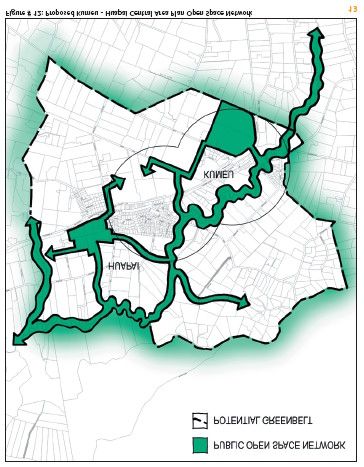
CONTENTS

1.0      Introduction
1.1      Summary
1.2      Introduction Detail

2.0      Context legislation and relevant documents
2.1      The Auckland Regional Growth Strategy: 2050
         2.1.1 The Growth Concept
2.2      Northern and Western Sectors Agreement
2.3      Auckland Regional Land Transport Strategy 2003
2.4      Auckland Regional Policy Statement
         2.4.1 ARPS Regional Overview and Strategic Direction (Chapter 2)
         2.4.2 ARPS Transport (Chapter 4)
         2.4.3 Assessment - Auckland Regional Policy Statement 1999 and Relevant Proposed
                Changes to the Regional Policy Statement.
2.5      Other Statutes

3.0      Local Context
3.1      Rodney District Plan
3.2      Kumeu Huapai Central Area Plan 2005
3.3      Rodney District Development Design Guide 2008.
3.4      Vision Rodney
3.5      Planning Rodney

4.0      Issues

5.0      Desired Outcomes

6.0      Site Factors
6.1      Topography and location
6.2      Geotechnical Issues
6.3      Catchment Management Plan
6.4      Infrastructure
         6.4.1 Water Supply
         6.4.2 Wastewater Servicing
         6.4.3 Stormwater Reticulation
6.5      Transport
6.6      Visual Factors

7.0      Stakeholders
7.1      Stakeholders

8.0      Schedule of Amendments

9.0      Statutory Requirements

10.0     Evaluation
10.1     Section 32(3)(a) Are the objectives the most appropriate way to achieve the Purpose of
         the Act?
10.2     Section 32(3)(b) Having regard to their efficiency and effectiveness, are the policies,
         rules or other methods the most appropriate for achieving the objectives?
         10.2.1 Possible alteration of zone to a residential use.
         10.2.2 Proposed Policies
         10.2.3 Proposed Overall Residential Density.
         10.2.4 Possible amendments to Chapter 14                    Scheduled and Restricted
                  Activities to address site specific issues.
         10.2.5 Possible prohibited activity status for wastewater servicing.
         10.2.6 The use of a development concept plan approach for some areas.
         10.2.7 Possible use of urban design guidelines to guide subdivision and development.
         10.2.8 The use of Area specific development control rules.
         10.2.9 Summary
S.32 for Variation 127: Rezoning of land for Residential and Local Shops Purposes, Huapai North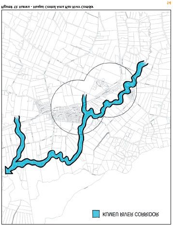
10.3     Section 32(4)(a) What are the benefits and costs of policies, rules or other methods?
         10.3.1 Cost benefit and risk analysis - Section 32 (4) (a) obligations
                  10.3.1.1     Possible alteration of zone to a residential use.
                  10.3.1.2     Proposed Policies.
                  10.3.1.3     Proposed Overall Residential Density.
                               10.3.1.3.1 Matrix of District Plan Changes v s Desired Outcomes.
                  10.3.1.4     Possible amendments to Chapter 14           Scheduled and Restricted
                               Activities to address site specific issues.
                  10.3.1.5     Possible prohibited activity status for wastewater servicing.
                  10.3.1.6     The use of a development concept plan approach for some areas.
                  10.3.1.7    Possible use of urban design guidelines to guide subdivision and
                               development.
                  10.3.1.8 The use of Area specific development control rules.
10.4     Section 32(4)(b)       What is the risk of acting or not acting if there is uncertain or
         insufficient information about the subject matter of the policies, rules or other methods?

11.0     Consultation and Supporting Documents
11.1     Consultation
11.2     Supporting Documents

12.0     Conclusion

Appendices

Appendix A        Huapai North Proposed Zoning Map.
Appendix B        Proposed Huapai North Outline Plan.
Appendix C        RDC Agenda Item July 2009.
Appendix D        Huapai North Outline Plan, Proposed Road Layout, Stage 1 Safety Audit, T2
                  Engineers.
Appendix E        Huapai North: Integrated Transport Assessment, Beca Infrastructure Ltd.
Appendix F        Draft ICMP for Stormwater Management.
Appendix G        Huapai Garden Village Report Stage 1, Chow Hill.
Appendix H        Kumeu       Huapai Central Area Plan.
Appendix I        Figures
                  - Figure 1 Zoning Map
                  - Figure 2 Existing and Future Areas
                  - Figure 3 Planning Rodney Map 3
                  - Figure 4 Aerial Photograph

S.32 for Variation 127: Rezoning of land for Residential and Local Shops Purposes, Huapai North
1.0 INTRODUCTION
1.1 Summary
This report has been prepared in accordance with Section 32 of the Resource
Management Act 1991 (RMA). It examines the appropriateness of objectives, policies
and rules, and considers costs and benefits of options for a proposed Variation to the
Rodney District Plan 2000 Operative in Part (RDP-OP) to rezone an area of land for
residential and local shops purposes in Huapai. The proposed Variation introduces a
new Special 29 Zone in Huapai North and removes references to the Huapai North
Structure Plan in the District Plan.
1.2 Introduction Detail
This analysis is an evaluation of a proposed variation to the Rodney District Plan 2000
Operative in Part in the context of the Resource Management Act 1991, the Auckland
Regional Policy Statement (ARPS) and various other relevant planning documents and
strategies.
Rodney District is characterised by steady and strong population growth, reflecting in
substantial development throughout the district. The demand for residential land has
been considered in recent years through the Auckland Regional Growth Strategy and
Northern and Western Sector Agreements and the Council has responded to
development pressures in the Huapai North area by identifying land within the Huapai
area as Future Urban . As land zoned Future Urban, it is considered to form a part of the
rural settlement of Huapai and is considered to be within the Metropolitan Urban Limits
(MUL s) set out in the ARPS.
The proposed variation alters the RDP-OP zoning of land in Huapai North. The majority
of the land affected by the proposed variation is currently zoned Future Urban and is the
subject of the adopted Kumeu Huapai Central Area Plan.
The proposed variation introduces a new Special 29 Zone in Huapai North that reflects
the proposals contained in the adopted Kumeu Huapai Central Area Plan. As a
consequence of applying a live zoning, the variation also removes references to the
previous Huapai North Structure Plan, as the live zoning means these are no longer
required.
The Special 29 Zone applies to the area generally bounded by State Highway 16, the
Kumeu River to the east and north and a natural waterway to the west being Coopers
Creek. The existing developed area north west of Oraha Road, including the southern
portions of Tapu and Matua Roads is not included in the variation.
The Special 29 Zone includes policy areas for local shops and residential areas within
Huapai North.
The provisions of the Special 29 Zone are intended to enable contained residential
expansion within the area and the application of urban design principles to all
development to achieve community and environmental outcomes. The development of
the area is intended to respect and reflect key elements of the area s former rural
character and to recognise Huapai s function as a rural town. A key principle
underpinning the planning and development of Huapai s residential area is the notion of
sustainability. This means that growth has been planned to achieve social, cultural,
economic and environmental benefits. A range of housing densities have been proposed
to provide for different lifestyles, roads have been proposed to include street trees, and
an area for local shops has been proposed to service some of the community needs.
An Outline Plan for the Special 29 (Huapai North) Zone (which is proposed to be included
within Appendix 9 of the Planning Maps) has been compiled to ensure that the
development of Huapai North will be carried out in an integrated way. This means that
the areas set aside for different functions and the different residential densities have been
considered together, and arranged to ensure they work to achieve positive urban
S.32 for Variation 127: Rezoning of land for Residential and Local Shops Purposes, Huapai Northoutcomes. The variation is part of the wider planning for Kumeu-Huapai and is linked to
the provision of infrastructure for the area. The outline plan sets out the location of each
of the policy areas, and of proposed reserves and proposed roads.
The roading pattern and layout are crucial to achieving the intended outcomes for the
area. Therefore a number of roads have been shown as indicative roads on the planning
maps. Also key to the character to the Huapai North area will be the finished cross
sections of the roads, landscaping, pedestrian and cycle ways etc and their relationship
with site layout and buildings. An Integrated Traffic Assessment has been undertaken to
address the predicted traffic transport effects of the proposed Variation and any
mitigation which is considered appropriate to remedy or mitigate these effects.
The area includes a range of residential densities with the greater intensity sites closest
to Huapai town centre and the Huapai Reserve extending out to lower intensity
residential sites near the rural fringe. The residential areas will have a rural village
focus. Other local community needs will also be met by the inclusion of local shops and
future reserve areas. It is considered that the proposed land uses will meet the
objectives for the area, taking into account the area s development constraints and
working with the unique opportunities that the area offers.
The Resource Management Act requires that the Council consider a number mandatory
requirements for developing Proposed Plan Changes and Variations. These are set out
in full in the Environment Court interim decision Long Bay-Okura Great Park Society
Incorporated and Others v North Shore City Council (Decision A078/2008) and are set
out below.
A. General requirements
1. A district plan (change) should be designed to accord with, and assist the
territorial authority to carry out - its functions so as to achieve, the purpose of
the Act.
2. When preparing its district plan (change) the territorial authority must give
effect to any national policy statement or New Zealand Coastal Policy
Statement.
3. When preparing its district plan (change) the territorial authority
shall:
(a) have regard to any proposed regional policy statement;
(b) not be inconsistent with any operative regional policy statement.
4. In relation to regional plans:
(a) the district plan (change) must not be inconsistent with an operative
regional plan for any matter specified in section 30(1) [or a water
conservation order]; and
(b) must have regard to any proposed regional plan on any matter of
regional significance etc;
5. When preparing its district plan (change) the territorial authority must also:
have regard to any relevant management plans and strategies under
other Acts, and to any relevant entry in the Historic Places Register
and to various fisheries regulations; and to consistency with plans and
proposed plans of adjacent territorial authorities;
take into account any relevant planning document recognised by an
iwi authority; and
not have regard to trade competition;
6. The district plan (change) must be prepared in accordance with any
regulation (there are none at present);
7. The formal requirement that a district plan (change) must also state its
objectives, policies and the rules (if any) and may state other matters.
S.32 for Variation 127: Rezoning of land for Residential and Local Shops Purposes, Huapai NorthB. Objectives [the section 32 test for objectives]
8. Each proposed objective in a district plan (change) is to be evaluated by
the extent to which it is the most appropriate way to achieve the purpose of
the Act.
C. Policies and methods (including rules) [the section 32 test for policies and
rules]
9. The policies are to implement the objectives, and the rules (if any) are to
implement the policies;
10. Each proposed policy or method (including each rule) is to be examined,
having regard to its efficiency and effectiveness, as to whether it is the
most appropriate method for achieving the objectives of the district plan
taking into account:
(a) the benefits and costs of the proposed policies and methods (including
rules); and
(b) the risk of acting or not acting if there is uncertain or insufficient information
about the subject matter of the policies, rules, or other methods.
D. Rules
11. In making a rule the territorial authority must have regard to the actual or
potential effect of activities on the environment.
E. Other statutes:
12. Finally territorial authorities may be required to comply with other statutes.
Within the Auckland Region they are subject to:
the Hauraki Gulf Maritime Park Act 2000;
the Local Government (Auckland) Amendment Act 2004.
This report summarises this assessment for the Huapai North Special 29 Zone contained
within Proposed Variation 127.
2.0 CONTEXT LEGISLATION AND RELEVANT DOCUMENTS
2.1 The Auckland Regional Growth Strategy: 2050
The purpose of the Regional Growth Strategy is to ensure growth is accommodated in
a way that meets the best interests of the inhabitants of the Auckland Region . The
strategy provides a vision for what Auckland could look like in 50 years time with a
population of 2 million. This vision is to sustain:
strong, supportive communities;
a high quality living environment;
a region that is easy to get around; and
protection of the coast and surrounding natural environment.
Growth outcomes sought in the Regional Growth Strategy, include:
access and transport efficiency;
sustainable use of resources (land/ infrastructure/ energy);
business opportunity;
urban amenity;
safe, healthy communities;
housing choice / affordability;
employment choice.
2.1.1 The Growth Concept
The Growth Concept , is a snapshot of how the region could look at 2050 if growth is
managed according to the vision, outcomes and principles.
S.32 for Variation 127: Rezoning of land for Residential and Local Shops Purposes, Huapai NorthKey features of the Growth Concept are:
that growth will be managed by promoting quality, compact urban environments
(intensification);
most growth within the existing metropolitan area with development outside current
urban limits only where environmental, accessibility and community principles can
be met;
most urban growth focused around town centres and major transport routes to
create higher density communities, with a variety of housing, jobs, services,
recreational and other activities (mixed use);
much less emphasis on general infill throughout suburban areas.
Some expansion in new greenfield areas is necessary to provide sufficient land and
locational choice for dwellings and businesses. If all proposed greenfield development
proceeds, the Auckland region s metropolitan area will increase by about 10% or 5000
hectares, over the 50-year timeframe.
By 2050, more than a quarter of the population (more than 500,000 people) could be
living in higher density, multi-unit accommodation, compared with less than an eighth or
125,000 people in 1996. However, even after 50 years, 70% of people could still live at
lower densities in the suburbs and rural areas.
The Growth Strategy suggests that Rodney District could have a population capacity of
177,000 by the year 2050. In percentage terms, such a population growth represents
the biggest increase of all the territorial local authorities in the region, when considering
growth prospects up to the year 2050.
The Resource Management Act requires any District Plan to give effect to the Regional
Policy Statement and the Regional Policy Statement for the Auckland region is required
to give effect to the growth concept in the ARGS. Changes have been undertaken to
the Rodney District Plan 2000 Operative in Part through Variation 22 and to the
Regional Policy Statement through Plan Change 6 to align these documents with the
ARGS.
2.2 Northern and Western Sectors Agreement
The Northern and Western Sectors Agreement sets out the fundamental elements and
form of future development for the Rodney District. For the western portion of the
Rodney District the key components are:
Focus residential development in the west on the key settlements of: Kumeu-
Huapai, Helensville and Riverhead; and
Encourage the development of Helensville-Parakai as a key employment and
settlement node.
One of the key objectives relevant to Huapai residential areas is to Manage the effects
of growth in the rural areas on rural character and amenity.
The area of land which is the subject of the current variation was zoned Future Urban
under the Proposed District Plan at the time that the Sector Agreement was finalised in
2001.
2.3 Auckland Regional Land Transport Strategy 2003
An efficient transport system is vital to the prosperity of the Auckland Region and to the
well-being of the people of Auckland. Transport and land use are closely interrelated.
Transport systems can both service development and can also facilitate future
development patterns.
The Growth Concept anticipates a shift in land use patterns towards a more compact
urban form which focuses growth in more intensive mixed-use centres along the
northern, western and southern passenger transit corridors, as well as near main arterial
S.32 for Variation 127: Rezoning of land for Residential and Local Shops Purposes, Huapai Northroads. More intensive development can support a greater range of local services and
facilities, increase the opportunity for safe walking and cycling and help support
passenger transport, by bringing people closer to the main routes. Careful design will be
needed to ensure good urban amenity.
The Auckland Regional Land Transport Strategy (ARLTS) (prepared under Section 175
of the Land Transport Act 1998) outlines the requirements for an integrated transport
system able to cope with the demands of many more people living and working in the
Region for the next 10 years and supporting the land use patterns promoted by the
Regional Growth Strategy. The ARLTS 2005 places more emphasis on public transport
and on travel demand management (TDM) in particular on increasing walking and
cycling. However, the strategy recognises the need to complete the regions strategic
roading network as fast as funding will allow. The strategy also acknowledges that
although car travel will remain an important part of Auckland s transport system, the
region cannot accommodate relentless growth in car use. (ARLTS Summary Page 11).
Therefore TDM has been incorporated into the ARLTS and aims to reduce car trips and
to encourage more people to walk, cycle, catch public transport, carpool, and to work,
shop and play locally. (ARLTS Summary Page 11).
In order to achieve these objectives, the RLTS proposes region-wide and area-wide
policies. Some of the key regional objectives of the strategy of relevance to this variation
include the objective to Assist economic development , Improve access and mobility ,
Ensure environmental sustainability and Supporting the Auckland Regional Growth
Strategy .
2.4 Auckland Regional Policy Statement
2.4.1 ARPS Regional Overview and Strategic Direction (Chapter 2)
Section 59 of the RMA states that the purpose of a regional policy statement is:
... to achieve the purpose of the Act by providing an overview of the
resource management issues of the region and policies and methods
to achieve integrated management of the natural and physical
resources of the whole region.
The Auckland Regional Policy Statement 1999 (RPS) therefore, provides an overview of
the resource management issues relevant to the Auckland region and contains policies
and methods to enable the resources of the region to be managed in a sustainable and
integrated manner. The RPS has been subject to a number of recent plan changes.
Where relevant this assessment will refer to the decisions versions of any plan change.
Section 2.6 of the RPS identifies a Strategic Direction for the Auckland region. This
Strategic Direction is "one of containment of urban development within defined limits and
accommodating future growth within and around high density centres and corridors
linked by an effective public transport system. [Section 2.6 ARPS]"
In accordance with section 39(1) of the Local Government (Auckland) Amendment Act
2004, the ARC prepared and publicly notified Proposed Plan Change 6 "Giving Effect
to the Regional Growth Concept and Integrating Land use and Transport" ("RPS-PC6").
The purpose of RPS-PC6 is to integrate land transport and land use provisions and make
these consistent with the Auckland RGS. The decisions on Proposed Change 6 have
been released and a number of Sections are subject to appeal.
The Regional Policy Statement outlines the following Strategic Objectives (Section 2.6.1
of the RPS) which are relevant to the proposed variation. These are not outlined here in
detail as the area is located within the Metropolitan Limits and is currently zoned future
urban, so many, although not all, of these strategic objectives have been addressed
previously. However some of the key objectives are as follows:
Strategic Objective 2.6.1.1
S.32 for Variation 127: Rezoning of land for Residential and Local Shops Purposes, Huapai North1. To ensure that provision is made to accommodate the Region s
growth in a manner which gives effect to the purposes and principles of
the Resource Management Act, and is consistent with these Strategic
objectives and with the provisions of this RPS.
Strategic Objective 2.6.1.3
3. To achieve a compact well designed more sustainable urban form
served by an integrated multimodal (private vehicles, public transport,
walking and cycling) transport system.
Strategic Objective 2.6.1.5
5. To achieve a built environment within the region s metropolitan area
and rural and coastal settlements that has a sense of identity and
character, has a range of densities and uses, maintains or enhances its
amenity values, and is visually pleasant, functionally efficient,
environmentally sustainable and economically vibrant.
Strategic Objective 2.6.1.11
11. To encourage the efficient use of natural and physical resources,
including urban land, infrastructure, and energy resources.
Strategic Objective 2.6.1.15
15. To improve the overall health, well being and quality of life of the
people of the Region.
Strategic Objective 2.6.1.17
17. To develop a network of high density centres and corridors as the
focus for the region s growth.
The ARPS also sets out a number of strategic policies and methods to achieve these
objectives. The Strategic Policies of the RPS fall under six headings, being urban
containment, urban structure, urban design, land use and transportation integration,
infrastructure and rural areas. All of these are relevant to the rezoning of land for
residential purposes to some degree.
The ARPS amendments include the introduction of new Schedules 1 and 2. Schedule 1,
sets out areas in the Region where urban intensification will be encouraged through
district plan changes. Schedule 1 includes the area Future Urban area Kumeu / Huapai .
The ARPS methods also require each territorial authority to include a programme for the
sequencing and timing of the development of areas identified in Schedules 1 and 2 to
accommodate growth based on a twenty year time frame . It is anticipated that the
area to be rezoned will be available for development immediately. This falls within the
timeframe stated in the ARPS of 2005 - 2020.
2.4.2 ARPS Transport (Chapter 4)
Chapter 4 of the ARPS has been amended to recognise the role that transportation has
in the urban form and the ARPS (as amended and subject to appeal) seeks To develop
a transport network which supports a compact sustainable urban form. (Objective 4.3-1).
One way of achieving the transport objectives of the ARPS is in particular through Policy
4.4.1 which proposes to integrate land use and transport planning in way which
reduces the need for private vehicle travel and significantly increases the amount of
travel made by public transport, walking and cycling (Policy 4.4.1-1) has been amended
to recognise the positive role of transportation in leveraging development within high
density centres and corridors. The Chapter 4 discusses a transport system which
supports more intensive forms of development in the Auckland Region. This chapter of
the ARPS recognises that As the region grows the transport network will be required to
increase in capacity to service this growth. (Issue 4.2.1 discussion). If managed
properly this growth can support the urban containment objectives and policies of the
ARPS, however Inappropriate land uses can have an adverse effect on the effective and
efficient operation of the transport system (Issue 4.2.1 discussion).
S.32 for Variation 127: Rezoning of land for Residential and Local Shops Purposes, Huapai NorthThe subject area for rezoning is ideally located near State Highway 16, next to the
Huapai town centre and is a short distance from the rail terminal should this be
upgraded and continue in the future.
2.4.3 Assessment - Auckland Regional Policy Statement 1999 and Relevant Proposed
Changes to the Regional Policy Statement.
As the majority of the area to be rezoned is already zoned as Future Urban it forms a
part of the rural settlement of Huapai and as such is considered to be within the
Metropolitan Urban Limits. Therefore a full assessment of the variation against the urban
containment policies is not required. Furthermore, in accordance with the ARPS a
Structure Plan for the area has been completed and residential development is
anticipated.
The projected population for the Huapai North area, although not high in density per
hectare, is considered appropriate for the character of the rural village and does provide
a range of housing and site size choices for future residents. Further to this the Kumeu
Huapai Central Area Plan outlines that the community seek a maximum of 10,000
persons for Kumeu and Huapai area up to the year 2050. As outlined further in Section
2.1 of this report, it is considered that the projected population will be in line with this
figure once other areas are developed.
Overall, it is considered that the proposed variation will give effect to the ARPS.
2.5 Other Statutes
It is considered that the provisions of the Hauraki Gulf Maritime Park Act 2000 are not
relevant to the zoning of the subject land.
3.0 LOCAL CONTEXT
3.1 Rodney District Plan
The subject land to be zoned for residential and local shops purposes is zoned Future
Urban in the Rodney District Plan 2000 Operative in Part (refer to Figure 1 attached as
Appendix I). The strip of land between the Future Urban area and river is zoned General
Rural in the Rodney District Plan 2000 Operative in Part, some additional restrictions in
this area are being proposed. The land adjoins the Huapai Reserve which is zoned for
Open Space purposes to the south and adjoins an area of established residential land to
the south east. Land to the south of State Highway 16 is zoned either Future Urban or
for Residential purposes in the Rodney District Plan 2000 Operative in Part, while land
to the west and north beyond the Kumeu River is zoned General Rural in the Rodney
District Plan 2000 Operative in Part. Refer to Figure 1 attached as Appendix I.
The Huapai North area is also specifically outlined in Chapter 13 Future Urban and
Structure Plan Areas, rule 13A.4 Huapai North Structure Plan Area. This rule describes
the Huapai North area, in particular how it was envisaged, at the time the Proposed
District Plan 2000 was notified, that the area would be development in terms of
residential, open space, roading and engineering services. Appendix 6, Figure 4 of the
Rodney District Plan 2000 Operative in Part Maps shows an outline of the Huapai
North Area.
The Rodney District Plan 2000 Operative in Part includes a number of objectives
relating to the provision of urban land including business land and the location of this
land. The key objectives in this regard are within Chapter 13 Future Urban and are as
follows:
Objective 13.3.1 To ensure that sufficient land is available for future
urban growth including future residential activity and future urban
business activity.
S.32 for Variation 127: Rezoning of land for Residential and Local Shops Purposes, Huapai NorthObjective 13.3.2. To ensure that urban growth occurs within
metropolitan urban limits and in coastal and rural settlements on land
that has been identified for urban growth.
Objective 13.3.4 To ensure that urban development in new greenfield
areas has a high level of amenity value.
Objective 13.3.5 To ensure that opportunities exist for key facilities that
may be required by the population of developing urban areas, such as
business areas and community facilities.
Objective 13.3.7 To ensure that existing lawfully established activities
in future urban areas, which have the potential to create adverse
effects on more sensitive uses that encroach upon them as a result of
urban expansion, are not adversely affected.
Proposed Variation 22 is the Rodney District s response to the Local Government
(Auckland) amendment Act 2004. This Act requires that all councils in the Auckland
Region integrate their land transport and land use provisions in order that they can give
effect to the Auckland Regional Growth Strategy. The Act also requires Councils to
ensure that their plans are in keeping with the Auckland Regional Policy Statement.
Variation 22 provides a schedule of growth areas. The subject site is one of the areas
identified and for residential zoning in 2006. It is considered that the proposed variation
is consistent with Variation 22 and the direction of the Rodney District Plan 2000
Operative in Part.
3.2 Kumeu Huapai Central Area Plan 2005
The Kumeu Huapai Central Area Plan was adopted in December 2005 following a
review of the 1998 Kumeu Huapai Waimauku Structure Plan. The subject site is located
within the Central Area Plan study area as shown in Figure 7 of the Structure Plan below.
The Huapai North area is identified as Future Urban with Public Open Space linkages
extending from the Huapai Reserve.
With regard to population and density, the Central Area Plan recommends the following
(page 7 Central Area Plan):
That the 2051 population cap for the Kumeu-Huapai township be set at 10,000
residents rather [than] the 16,000 figure proposed by ARC.
That the recommended population cap be reflected in official zoning and land-
use (i.e. future urban areas, residential zoning and density).
That the re-location of the additional 6,000 residents be identified as soon as
possible to clarify the future land-use composition of the wider area.
The Central Area Plan (page 12) states that the 2001 Kumeu-Huapai Central Area Plan
made a series of recommendations relating to the need for higher residential densities,
largely in response to the growing pressure on the area to accommodate a higher
population base. It goes on to state that since that time the community has expressed
considerable concern over the potential adverse impacts that higher density residential
housing may have on the identity and character of the area. Of particular concern were
the potential adverse effects on the areas rural character and its sense of community.
S.32 for Variation 127: Rezoning of land for Residential and Local Shops Purposes, Huapai NorthHuapai North
The development of a comprehensive urban design guide for all future residential
development in the area is recommended in the Central Area Plan and that higher
density residential development in the 250 400sm section range, is to be allowed but
restricted to the Huapai Town Centre area and a localised areas adjacent to open space
areas.
With regard to existing activities which have developed over time either within or
outside industrial or rural zoned areas and need to be protected from new activities which
may suffer adverse effects from the existing activities i.e. reverse sensitivity issues must
be identified an avoided. (Page 12 Central Area Plan). This is relevant in particular to
the existing horticultural or farming activities on rural land adjoining the future residential
area.
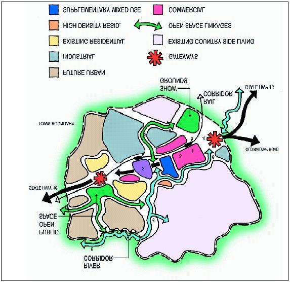
The importance of Open Space Networks (page 13) linking the Huapai Reserve to the
River and the Kumeu River Corridor (page 14) as a flood protection corridor and fully
integrated with the open space network for recreational opportunities is outlined in the
Central Area Plan as shown below.
S.32 for Variation 127: Rezoning of land for Residential and Local Shops Purposes, Huapai NorthFollowing the adoption of the Central Area Plan, Chow Hill assisted Rodney District
Council in compiling a report which was intended to assess development scenarios for
Huapai s residential development in preparation for the Huapai Residential Plan Change
(Section 1.1, Huapai Garden Village Report Stage 1) and in particular, to provide design
guidance and standards for the area. (Refer to Appendix G). This document was a
useful tool, however, it was never put to Council for adoption.
3.3 Rodney District Development Design Guide 2008
Rodney District Council completed the Rodney District Development Design Guide in
2008 in order to provide a non-statutory design guide which advocates quality design
responses to typical development challenges in Rodney. This guide was a useful tool in
assisting with the compilation of the Urban Design Guidelines for Huapai North.
3.4 Vision Rodney
Vision Rodney is an overarching policy document used by Rodney District Council to
guide activities, plan formulation etc. It is a relevant document to consider in the Section
32 Analysis for the proposed variation. Vision Rodney includes six community outcomes
including Prosperous, Vibrant, Distinctive, Connected, Safe and healthy and Clean and
green. The outcome statements outlined in this document are as follows:
Outcome Prosperous - Outcome Statement is We will have a growing
and resilient economy based on a wide variety of businesses that fit our
character.
Outcome Vibrant - Outcome Statement is We will have a range of
recreational and cultural facilities and events across the district and we
will encourage creativity and diversity.
Outcome Distinctive Outcome Statement is We will maintain and
enhance the character of our townships and rural areas through
excellent urban and rural planning and the intelligent management of
growth.
Outcome Connected - Outcome Statement is We will have the
infrastructure and services needed for our residents, business and
visitors.
S.32 for Variation 127: Rezoning of land for Residential and Local Shops Purposes, Huapai NorthOutcome Safe and Healthy - Outcome Statement is We will continue to
have a sense of community and we will provide for the emotional and
physical well-being of our people.
Outcome Clean and Green Outcome Statement is We will continue
to value, protect and enjoy the natural environment.
The proposed variation is considered consistent with Vision Rodney in that it will maintain
and enhance the character of our townships and rural areas through careful rural
planning and management of growth balanced between the ARGS and community
outcomes sought. Additionally, mechanisms have been recommended in the rules to
ensure that the required servicing infrastructure is available prior to any development
commencing.
3.5 Planning Rodney
Planning Rodney 2009 is A strategic, future focussed picture of the district based on
known growth, economic, social, environmental and cultural factors, that indicates the
direction we, as a district, are heading in. It provides focus and the staging by which we
will get there. (Executive Summary Planning Rodney). It proposes a conceptual future
for the district of Distinctive towns and villages set in a stable rural landscape and a well-
protected natural environment. (Executive Summary Planning Rodney).
The Huapai North area is included within the schematic areas shown on Map 1 of
Planning Rodney as an area of Intensive Rural Production , and Rural residential
(lifestyle) . The Huapai/Kumeu area is also identified as a Primary growth and
employment centre .
The area is described as the Central and Southern mixed rural area (Map 2 Planning
Rodney) which is defined as an area of mixed intensive rural activity, horticulture,
viticulture and tourist related activities as well as a lifestyle lots and a large number of
significant natural areas.
Map 3 of Planning Rodney identifies the Huapai/Kumeu area as a Primary growth and
employment centre. Refer to Figure 3, Appendix I of this document. In particular these
growth areas, of which there are four in Rodney, are characterised by the following:
Include Rodney s largest urban concentration.
Are significant employment and economic generators.
Include a wide range of services and facilities.
Kumeu-Huapai and Silverdale are the largest employment centres in
the district.
Overall, it is considered that the proposal is consistent with Planning Rodney, as the
variation will enable residential development in an area that is has been identified as a
growth area within the District.
4.0 ISSUES
The single key issue which has been the catalyst for this variation to rezone land from
Future Urban to a Residential Zone is as follows:
Issue 1
There is a lack of residential zoned land within the Rodney District to support its
growth and to meet regional growth expectations.
Refer to Section 3.2 for more detail on the future residential land as proposed within
the Kumeu-Huapai Central Area Plan.
Other minor issues with regard to this specific area being rezoned are as follows:
S.32 for Variation 127: Rezoning of land for Residential and Local Shops Purposes, Huapai NorthIssue 2
Land which is zoned as future urban does not provide certainty for residential uses
and does not allow for a range of residential densities. Future urban zoned land
does not allow for the development of the land for residential purposes while
maintaining the rural aspects of the area. Sites that are not suitable for residential
uses are unable to avoid or mitigate any adverse visual and character effects on the
environment. Future urban zoned land may not allow for sustainable development to
occur within particular environments.
Although additional residential land is required in the Rodney District, it is necessary
to ensure that the adverse effects of the rezoning are no more than minor and can
be avoided, remedied or mitigated.
Issue 3
Land which is not serviced by a reticulated system can not effectively provide for
residential development.
Residential development can occur without a reticulated system, however the
planning of residential areas alongside the provisions for water, wastewater and
stormwater allows for development which is compatible with these services.
Issue 4
The adverse effects of urban development should be avoided, remedied and
mitigated, this includes consideration of existing land uses, effects on natural areas
such as watercourses, overland flowpaths and effects on the character and amenity
of the area.
In the change from a rural form of development to an urban form, consideration must
be given to designing a rule package and layout that avoids, remedies and/or
mitigates adverse effects.
5.0 DESIRED OUTCOMES
The purpose of the variation is to provide an additional supply of residential land in
Huapai that is consistent with character of the town and provides for future growth in a
manner that is consistent with the sustainable management purpose of the Resource
Management Act 1991.
6.0 SITE FACTORS
6.1 Topography and location
The Huapai North area is located north of State Highway 16, east of Coopers Creek and
south and west of the Kumeu River. Refer to Aerial Photograph attached as Appendix I,
Figure 4 to this report. The area generally has a level topography, although there are
some gently rolling slopes due to natural waterways within the area.
The Huapai Reserve is located centrally adjacent to State Highway 16. Three
watercourses extend from this reserve to the Kumeu River and Coopers Creek.
The areas adjacent to Coopers Creek rise steeply and as such are not highly prone to
flooding. While the areas adjacent to the Kumeu River are low lying and prone to flooding
and as such have not been included in the proposed residential development area.
Farm dwellings and rural lifestyle housing is dotted around the Huapai North area. One
development of 1500m2 sites on Orchard Lane and Maple Lane was granted by the
Environment Court and has been developed in a manner which enables subdivision to
750m2 sites in the future.
S.32 for Variation 127: Rezoning of land for Residential and Local Shops Purposes, Huapai NorthThere are a number of rural and horticultural activities within the flooding area that exists
close to the Kumeu River. Additionally a substation exists within this area and high
voltage transmission lines traverse the area.
Beyond Coopers Creek and the Kumeu River, the sites are zoned General Rural and to
the south east the area adjoins an area of existing residential properties.
6.2 Flooding and Geotechnical Issues
With regard to geotechnical issues it is noted that the Kumeu-Huapai Central Area Plan
includes a brief report entitled Geotechnical Constraints May 2000. There is no evidence
to suggest that geotechnical issues are of concern in this area and it is considered that
this should have been dealt with at the time the site was identified for a Future Urban
use.
With regard to flooding, the Huapai North area is generally low lying. However, Council s
Stormwater Engineers have had modelling undertaken to determine the 1 in 100 year
flood areas. These flood prone areas have not been included in the proposed residential
area for development, with the exception of a small area in the south east of Huapai
North over which controls have been imposed to address flooding issues. The Integrated
Catchment Management Plan for the area and rules within the proposed variation,
together ensure that flooding within the catchment is not exacerbated.
6.3 Catchment Management Plan
The Integrated Catchment Management Plan (ICMP) for the Helensville/Kumeu area is
currently in final draft form and it is understood that an application for discharge consent
from the Auckland Regional Council will be lodged towards the end of the year. The draft
ICMP has been reviewed by the ARC and is currently undergoing minor amendments.
The draft ICMP includes mechanisms to deal with stormwater from the proposed
residential area.
The local stormwater infrastructure required to serve the subject area is addressed below
in the later sections of this report.
6.4 Infrastructure
6.4.1 Water Supply and Network
It is expected at this stage that Watercare will provide a water supply at Brighams Creek
by 2013/14. Watercare will build the bulk supply point, and the Rodney District Council
will fund this, however the agreements between Watercare and the Council have not yet
been finalised.
Rodney District Council is expected to build the stage 1 bulk supply infrastructure (rising
main, reservoir, gravity mains) by 2012/13, which is expected to service up to 2030.
It is also anticipated that RDC will build three principle fire mains in 2013/14: Package A
(Main Rd / Access Rd) to service the Kumeu industrial area; Package B (Matua Rd /
Tapu Rd) to service Huapai future residential area; Package C (Kaipara Portage Rd /
Coatesville Riverhead H way) to service Riverhead future residential area. A possible
Package D (Matua Rd / Gilbransen Rd / Main Rd) may also be built within the 2009-19
LTCCP period depending on demand.
Developers will fund other reticulation required to service their properties. The reticulation
is to be extended to existing properties as and when:
demand exists
economic circumstances permit
there is a need to do so in order to maintain security of supply.
S.32 for Variation 127: Rezoning of land for Residential and Local Shops Purposes, Huapai North6.4.2 Wastewater Servicing
6.4.2.1 Wastewater Drainage
Watercare Services Ltd (WSL) has informed the other network operators of its intention
to provide a wastewater discharge connection to urban areas of Kumeu, Huapai and
Riverhead. At the November 2008 meeting of Council it was resolved that the
connection to the WSL network was now the preferred option to supply wastewater
services in this area of the District. WSL agreed on 1 October 2009 to accept wastewater
from the Kumeu, Huapai, and Riverhead area from December 2011. The Council and
WSL are working together on Planning and design to achieve this deadline.
6.4.2.2 Wastewater Network
The Council has made a decision to use a pressure wastewater collection (PWC). PWC
is a system of collecting wastewater via a property owned onsite pump and delivering it
(under pressure) to a WSL wastewater treatment plant.
Chapter 20 - Wastewater Drainage of General Bylaw 1998 sets out the obligations on
property owners located in the PWC areas of Huapai, Kumeu and Riverhead. Property
owners are obliged to:
meet all equipment and installation costs, and operating and maintenance
costs of the PWC on the property, up to but not including the boundary kit
connecting to the public network;
ensure the PWC system is operating efficiently at all times;
ensure that maintenance of the PWC system is undertaken in accordance
with the manufacturer s specifications, by an Approved PWC Installer;
No person, other than an Approved PWC Installer, shall install, maintain
repair or renew a PWC system.
All technical requirements are set out in Chapter 5 of the RDC Standards for Engineering
Design and Construction.
The viability of the Wastewater drainage scheme in the Kumeu Huapai Riverhead (KHR)
area depends on no less than about 500 connections at the time the network begins
operating in December 2011. The project may get deferred until this number of
connections required is achieved.
In order to encourage this demand the Council has identified ways to financially assist
existing home owners in the KHR area who wish to connect to the public WW network.
These measures are available from 1 July 2010 and for the first three years from
commissioning of the public wastewater network in December 2011. The financial
assistance (except the loan option) applies to existing properties and to new
development.
In regard to connections, all new buildings will be required to connect to the public
wastewater Network. For existing premises, Chapter 20 - Wastewater Drainage bylaw
does not require compulsory connection, provided the existing onsite wastewater system
is operating satisfactorily and legally.
6.4.3 Stormwater Reticulation
River systems in some of the Huapai-Kumeu areas are prone to flooding and new
development increases hard surfaces, thus increasing storm water runoff with potential
accompanying problems.
A significant amount of work has been completed regarding the Kumeu-Kaipara river
catchment and its flood plains. This resulted in a draft Catchment Management Plan for
S.32 for Variation 127: Rezoning of land for Residential and Local Shops Purposes, Huapai Norththe Kumeu-Kaipara river catchment, covering an area of 270 square kilometres. The Plan
includes a number of scenarios that look at process affecting the catchment, future levels
of development anticipated in various parts of the overall catchment and actions to
ensure that development effects can be managed. This Catchment Management Plan is
currently being updated along with the modelling report to ensure that all documents are
current. The hydraulic models are being reviewed to allow for the preparation of
discharge consents for the proposed development. Some additional scenarios are also
being developed, and the model is being updated to reflect recent work at Maddren s,
Weza Lane and Taupaki. Once this report has been finalised it will then be publically
notified and there will be an opportunity to make submissions on this document.
The updated Integrated Catchment Management Plan will set out the following broad
rules:
In general stormwater drainage in new areas should be designed by the
property developer and approved by the Council.
Standards will provide for effective storm water and flood control;
management of development in the context of these important factors; and
development may not exacerbate erosion in watercourses.
All buildings shall be constructed clear of secondary flow paths, and habitable floor levels
of at least 500 mm above the 100-year flood plain and/or crown of adjacent road, shall be
enforced within the area. Drainage easements shall be registered on all new titles for
secondary flow paths though private property, however wherever possible flow paths
shall be located along public roads. Developments will need to control flows so that
erosion in watercourses is not accelerated or exacerbating erosion.
The proposed development areas of Huapai North as identified within the variation are
outside the existing flood plain and have been planned so there will be no net loss of
flood plain and flood plain storage. There will still be areas in the catchment that
continue to flood, but the new development will not make the existing flood situation
worse. The proposed variation will implement limits on impermeable surfaces as well as
on site coverage to ensure that stormwater runoff is not exacerbated.
6.5 Transport
The Huapai North area is accessed via Tapu Road or Matua Road off State Highway 16
to the south or via Matua Road to the west.
The transportation within the area was originally assessed through the Huapai/Kumeu
Central Area Traffic Assessment within the Kumeu-Huapai Central Area Plan (refer to
Appendix H). This assessment provides details about the existing traffic situation (in 2005
at the time which the Central Area plan was developed), the potential impacts of growth,
and details some of the future transport plans for the area. The report states that the
railway station is a key element of the transportation plan for the area, and the links to
this area proposed by the New Zealand Transport Agency (formerly known as Transit
New Zealand).
More recently an Integrated Transport Assessment has been undertaken by Beca
Infrastructure Limited entitled Huapai North: Integrated Transport Assessment dated 13
November 2009, this is attached as Appendix E. The report addresses the predicted
traffic and transportation effects of the proposed variation and any mitigation which is
considered appropriate to remedy or mitigate these effects.
A safety audit has been undertaken by T2 Traffic and Transportation Engineers Ltd which
is attached as Appendix D. This is an independent peer review of the safety features of
the proposed road layout within Huapai North. The report identified potential safety
problems for road users and ensures that measures are considered to eliminate or
reduce the problems. The outcomes of this report have been used to improve the
proposed roading layout for Huapai North and reduce potential safety risks for road
users.
S.32 for Variation 127: Rezoning of land for Residential and Local Shops Purposes, Huapai NorthIt is expected that the Matua Road/SH16 intersection is likely to be signalised by 2016 in
order to improve safety at that intersection. It is also proposed that Tapu Road
intersection be signalised to accommodate for the growth proposed within the Huapai
North area.
The internal road layout has been proposed to limit the creation of culs de sac and to
encourage walking and cycling.
The New Zealand Transport Agency (NZTA) is currently undertaking a Kumeu-Huapai
study entitled Project Quality Plan SH16 Kumeu to Huapai Transportation Study which
will address the balancing of land uses and transport within the area to enable
improvements for the state highway network and the Kumeu-Huapai townships. The
objectives of the study include preserving the strategic function of SH16, reducing
severance caused by SH16, and providing for pedestrians and cyclists in order to
encourage active modes of transport. This is likely to be completed in December 2009 or
January/February 2010.
A potential bus route through the area was previously proposed through the Kumeu-
Huapai Central Area Plan. However recent discussions with ARTA have indicated that
the improvement of existing bus stops and routes would be more effective. The variation
proposes the creation of pedestrian links which would allow for existing bus routes to be
utilised. A potential bus route through the area is not expected to be established in the
short to medium future.
6.6 Visual Factors
The Huapai North area is not considered to result in any visual effects that are more than
minor, given the existing Future Urban zoning of the area and its low lying location.
Bush clad hill slopes exist to the north, however, very little development exists on this
backdrop to the residential area.
7.0 STAKEHOLDERS
The following stakeholders have been identified in this analysis:
Existing and Future Landowners in Huapai/Kumeu.
Future Potential Landowners and Residents.
Kumeu-Huapai Resident s and Ratepayer s Group and formerly Kumeu
Executive Group.
Neighbouring Rural Landowners.
Iwi
Rodney District Council
Auckland Regional Council
Northern and Western Sector Partners
Existing and Future Landowners in Huapai/Kumeu
This group includes the existing and future landowner(s) of the subject site in its current
partially-developed form. This party will be concerned about outcomes relating to the
ability for their site to be developed and will have particular interest in any additional
restrictions placed on this site to avoid or mitigate effects.
Future Potential Landowners and Residents
This group includes those persons who establish a residential use on the site or own
future parcels of land if the site is rezoned for residential purposes. This group may
include existing home owners or new residents establishing in the area. Future
landowners and home owners would likely have similar concerns to the existing
landowners above and may also be more focussed on providing developments with a
level of amenity to suit future residents and in accordance with the urban design
guidelines and other sustainability aspects of the variation.
S.32 for Variation 127: Rezoning of land for Residential and Local Shops Purposes, Huapai NorthKumeu-Huapai Resident s and Ratepayer s Group (and formerly Kumeu Executive
Group)
The Kumeu Executive Group was set up by the Council to take part in the Central Area
Plan process, and was disbanded when this structure plan was completed. The Kumeu-
Huapai Resident s and Ratepayer s Group is considered to be a stakeholder group. This
group will likely be concerned about ensuring the provision of additional residential land
and ensuring that this is undertaken in a manner that integrates well with the existing
Kumeu-Huapai rural and residential areas. This group also represents business owners
who may be concerned about the viability of businesses in the area. The proposed
variation is likely to provide a new source of customers for these local businesses.
Neighbouring Rural Landowners
This group includes those owners of rural land adjoining or nearby the site. This group
would be concerned about any impact of future development on their land holdings and
the character/amenity values within the area.
Iwi
Iwi may be concerned to ensure that any planning provisions and the rezoning of land
does not compromise matters of cultural concern. There are no known sites of
archaeological significance on the site on the Council s records.
There was A Preliminary Cultural Heritage Assessment for the Kumeu-Huapai Structure
Plan, Rodney District Council completed for the Kumeu-Huapai Structure Plan (Refer to
Central Area Plan in Appendix H). This report concludes that there are no recorded
archaeological sites and few places of cultural significance within the area.
Rodney District Council
The Rodney District Council will be concerned with ensuring that adequate residential
land is provided to meet the needs of the District, that the community s vision through
Vision Rodney and Planning Rodney is realised and that any Rodney District Plan
Operative in Part changes achieve the purpose of the Resource Management Act 1991.
Auckland Regional Council
The Auckland Regional Council will be concerned with ensuring that any additional
supply of residential land is consistent with the Auckland Regional Growth Strategy in
regard to the residential densities and the overall estimated population of the area. They
will also be concerned with the consistency of the variation with the Northern and
Western Sectors Agreement and the Auckland Regional Policy Statement.
Northern and Western Sector Partners
This group includes representatives from North Shore City Council and Waitakere City
Council alongside Rodney District Council. This group will seek to ensure that urban
growth occurs in a manner that is consistent with the intent of the Regional Growth
Strategy, the Northern and Western Sectors Agreement and results in a sustainable
urban form for the region as a whole.
S.32 for Variation 127: Rezoning of land for Residential and Local Shops Purposes, Huapai North7.2 Stakeholders
The extent to which the stakeholder groups (horizontal axis) seek the desired outcome (vertical axis).
Desired Outcome: To provide an additional supply of residential land in Huapai that is consistent with character of the town and provides for future growth in a
manner that is consistent with the sustainable management purpose of the Resource management Act 1991.
Yes = seek the desired outcome
No = do not seek the desired outcome
Neutral = no position either way on desired outcome
Table 1: Stakeholders v s Desired Outcomes
Existing and Future Landowners in Huapai/Kumeu.
Future Potential Landowners and Residents.
Kumeu-Huapai Resident s and Ratepayer s Group.
Neighbouring Rural Landowners.
Iwi.
Rodney District Council.
Auckland Regional Council.
Northern and Western Sector Partners.
Existing and Future Potential Neighbouring Kumeu- Iwi Rodney Auckland Northern and
Future Landowners in Rural Huapai District Regional Western Sector
Landowners in Huapai/Kumeu Landowners Resident s Council Council Partners
Huapai/Kumeu and
Ratepayer s
Group
Desired Outcome/
Evaluation Criteria 1: Yes Yes Neutral Yes Yes Yes Yes Yes
Additional land is zoned for
residential purposes.
Desired Outcome/
Evaluation Criteria 2: In
providing additional Yes Yes Yes Yes Yes Yes Yes Yes
residential land the potential
adverse effects on adjacent
S.32 for Variation 127: Rezoning of land for Residential and Local Shops Purposes, Huapai NorthYou can also read