England Coast Path Stretch: Newquay to Penzance Overview to Natural England's compendium of statutory reports to the Secretary of State for this ...
←
→
Page content transcription
If your browser does not render page correctly, please read the page content below
www.gov.uk/englandcoastpath

England Coast Path Stretch:
Newquay to Penzance
Overview to Natural England’s compendium of statutory reports to the
Secretary of State for this stretch of coast

1   England Coast Path | Newquay to Penzance | Overview
Map A: Key Map – Newquay to Penzance

2   England Coast Path | Newquay to Penzance | Overview
Report number and title
NQP 1: Newquay Station to Penhale Point (Maps NQP 1a to NQP 1i)

NQP 2: Penhale Point to St Agnes Head (Maps NQP 2a to NQP 2h)

NQP 3: St Agnes Head to Gwithian (Maps NQP 3a to NQP 3l)

NQP 4: Gwithian to Clodgy Point (Maps NQP 4a to NQP 4i)

NQP 5: Clodgy Point to Pendeen Watch (Maps NQP 5a to NQP 5j)

NQP 6: Pendeen Watch to Land’s End (Maps NQP 6a to NQP 6i)

NQP 7: Land’s End to Carn Barges (Maps NQP 7a to NQP 7g)

NQP 8: Carn Barges to Penzance Station (Maps NQP 8a to NQP 8f)

Using Key Map
Map A shows the whole of the Newquay to Penzance stretch divided into shorter numbered lengths of
coast.

Each number on Map A corresponds to the report which relates to that length of coast.

To find our proposals for a particular place, find the place on Map A and note the number of the report
which includes it.

If you are interested in an area which crosses the boundary between two reports, please read the relevant
parts of both reports.

Printing
If printing, please note that the maps which accompany reports 1 to 8 should ideally be printed on A3 paper.
If you don’t have the facility to print at A3 size, we suggest you print the text of the report you are interested
in on A4 paper and view the associated map on your computer screen, using the zoom tool to view it at a
suitable size.

3   England Coast Path | Newquay to Penzance | Overview
Contents
Report number and title ......................................................................................................................... 3
Using Key Map ............................................................................................................................................. 3
Printing .................................................................................................................................................. 3
Contents ....................................................................................................................................................... 4
Please read first! ........................................................................................................................................... 5
Introduction ................................................................................................................................................... 6
1. Improving coastal access ...................................................................................................................... 6
2. The determination process .................................................................................................................... 7
3. Understanding the proposals and accompanying maps ........................................................................ 8
Our Proposals:....................................................................................................................................... 8
Notes on how our Part 3 Proposals Tables work ................................................................................... 8
Notes on how our Part 4 Proposals Maps work .......................................................................................... 13
4. Preparation of the report ..................................................................................................................... 15
Stage 1 - Prepare ................................................................................................................................ 15
Stage 2 - Develop ................................................................................................................................ 16
Key issues along this stretch....................................................................................................................... 17
5. Discretion to include part or all of an estuary or estuaries.................................................................... 17
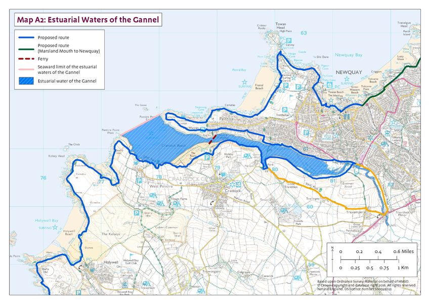
Gannel estuary .................................................................................................................................... 18
Map A2 showing estuarial limit of the River Gannel ............................................................................. 21
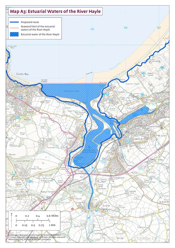
Hayle estuary....................................................................................................................................... 22
Map A3 showing estuarial limit of the River Hayle................................................................................ 24
6. Other considerations on this stretch .................................................................................................... 25
Map B: Existing public access on Newquay to Penzance .................................................................... 29
Map C: Key statutory environmental designations on Newquay to Penzance ...................................... 30
Map D: Key statutory landscape designations on Newquay to Penzance ............................................ 31
Other issues ............................................................................................................................................... 32
7. Future changes ................................................................................................................................... 32
8. Restrictions and exclusions ................................................................................................................. 34
Map E: Map showing overall effect of directions to restrict or exclude access on Newquay to Penzance
............................................................................................................................................................ 35
Annex A: Bibliography ................................................................................................................................ 36
Information about Natural England’s coastal access programme: ........................................................... 36
Information about the statutory framework for coastal access: ................................................................ 36
Environmental legislation referred to in the reports: ................................................................................. 36
Other published information used in the preparation of the report: .......................................................... 37
Annex B: Glossary of terms ........................................................................................................................ 38
Annex C: Excepted land categories ............................................................................................................ 43
Annex D: National restrictions ..................................................................................................................... 44
Countryside and Rights of Way Act 2000 .................................................................................................... 45
4 England Coast Path | Newquay to Penzance | Overview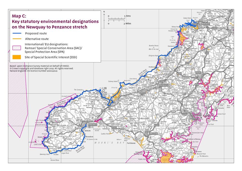
Please read first!
This Overview document sets out the context for Natural England’s proposals to improve public access to
and along the stretch of coast between Newquay and Penzance. It explains key common principles and
background underlying the detailed proposals that we make in our compendium of linked but legally
separate statutory reports, each covering a single length of coast within the stretch. Each of these reports
should be read in conjunction with this Overview.
Taken together, these reports explain how we propose to implement the England Coast Path (“the trail”) on
this stretch of coast, and detail the likely consequences in terms of the wider ‘Coastal Margin’ that will be
created if our proposals are approved by the Secretary of State. Our reports also set out:
any proposals we think are necessary for restricting or excluding coastal access rights to address
particular issues, in line with the powers in the legislation; and
any proposed powers for the trail to be capable of being relocated on particular sections (through
“roll-back”), if this proves necessary in the future because of coastal change.
So although this Overview has multiple reports associated with it, each report relating to a particular part of
the stretch makes free-standing proposals, and seeks approval for them by the Secretary of State in their
own right under section 52 of the National Parks and Access to the Countryside Act 1949.
We have carefully considered any potential environmental impacts of improving public access to this stretch
of coast, and made any necessary adjustments to our proposals prior to publication in order to address
these. Considerations in relation to environmental matters are explained in Section 6 of this Overview and
relevant reports for each length of coast. Links are provided to relevant separately published documentation
where appropriate.
The reports are published on our web pages as a series of separate documents, alongside this Overview
and more general information about how the Coastal Access programme works.
Each report is accompanied by detailed Proposals Maps for the relevant length of coast. The maps are
numbered according to the part of the report to which they relate. For example, maps NQP 1a to NQP 1i
illustrate the proposals in report NQP 1, which deals with the length from Newquay Station to Penhale
Point.
5 England Coast Path | Newquay to Penzance | Overview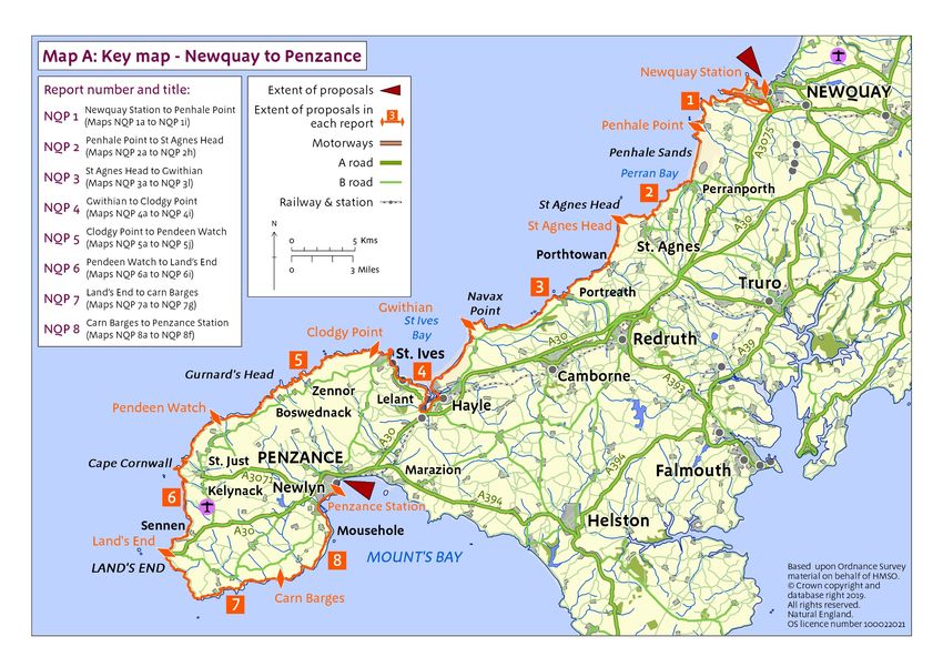
Introduction
1. Improving coastal access
Natural England has a statutory duty under the Marine and Coastal Access Act 2009 to improve access to
the English coast. The duty is in two parts: one relating to securing a long-distance walking route (“the trail”)
around the whole coast: we call this the England Coast Path; the other relating to a margin of coastal land
associated with the route which, in appropriate places, people will also be able to enjoy on foot. Associated
with this duty is a discretion given to Natural England to extend the trail up any river estuary on either or
both sides beyond the seaward limit of the estuarial waters 1, as far as the first bridge or tunnel with
pedestrian access, or as far as any point between the two.
To secure these objectives, we must submit statutory reports to the Secretary of State for Environment,
Food and Rural Affairs recommending where the route should be and identifying the associated coastal
margin. The reports must follow the approach set out in our methodology (the Coastal Access Scheme),
which – as the legislation requires – has been approved by the Secretary of State for this purpose.
This Overview and the related compendium of reports relate to the coast of Cornwall between Newquay
and Penzance. Taken together, our report proposals would make the following key improvements to the
existing arrangements for access to this part of the coast:
New sections of coastal path would be created in strategic places to link existing coastal paths into a
continuous route along this stretch of coast;
For the first time, there would be secure statutory rights of public access to most areas of beach, cliff
and other coastal land on this stretch of coast;
The coastal path would be able to ‘roll back’ as the cliffs erode or slip, or when other forms of
coastal change occur, solving long-standing difficulties with maintaining a continuous route on this
stretch of coast.
This is a significant opportunity to improve public access to this stretch of coast in these ways, with benefits
for residents, businesses and visitors. More people will have easier and more extensive access to the
coastal environment for open-air recreation, which is widely acknowledged to have significant benefits for
human health and well-being.
The 2009 Act refers to the continuous trail with its associated margin and other access rights as being the
‘England Coast Path’. Where appropriate we have used existing established coastal trail routes already
known by local and regional names, such as the South West Coast Path. However, there will be places
where the established trail and the proposed new coast path route diverge. To avoid confusion as to which
route is being proposed under the 2009 Act along this stretch of coast, it is intended to remain with the
terminology used in the Act namely the England Coast Path. It is recognised and welcomed that other local
established route names will continue to be used on the ground. Natural England will continue to work
closely with Cornwall Council and others in extending the use of Cornish as appropriate on new or
replacement signing.
Once approved and established, this part of the England Coast Path will be managed as part of the family
of National Trails.
1
section 301 of the Marine and Coastal Access Act 2009
6 England Coast Path | Newquay to Penzance | Overview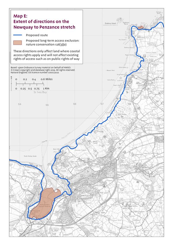
2. The determination process
Each of the reports for this stretch is submitted in accordance with our statutory duty under section 296 of
the Marine and Coastal Access Act 2009 (‘the 2009 Act’) to improve access to the English coast.
Publication of the reports has been advertised locally and online in accordance with the requirements of the
coastal access legislation.
Following publication:
Any person may make representations to Natural England about any of the reports; and
Any owner or occupier of affected land may make an objection to Natural England.
In order to be treated as valid, all objections and representations must be received by Natural
England no later than the end of the advertised eight week period following publication. The specific
closing date appears in the statutory notice for Newquay to Penzance, which can be viewed here
www.gov.uk/government/publications/england-coast-path-from-newquay-to-penzance-comment-on-
proposals together with more information about how to make representations or objections.
The Planning Inspectorate will consider any objections and any related representations before passing
recommendations to the Secretary of State, who in turn will consider both representations and objections
and then make a decision as to whether to approve our proposals. Chapter 3 of our Coastal Access
Scheme explains these processes in more detail (see Annex A: Bibliography).
The Secretary of State may confirm the proposals in each report in full, confirm some with modifications, or
reject some or all of them. If the conclusion is that some modification to our proposed approach is required,
further consideration may need to be given as to whether any further environmental assessment is
necessary. We may need to prepare an amended report for consideration by the Secretary of State, relating
to the part(s) of the coast affected by any rejected proposals. The same procedures for representation and
objection would apply to the amended report.
Once proposals for the stretch have been confirmed, there will be a preparation period before the new
access rights come into force. This period is to enable any necessary physical establishment of the trail to
be carried out and to put in place any necessary local management arrangements (including any approved
local access restrictions or exclusions).
Once the preparation period is complete, the rights will be brought into force by order on a date decided by
the Secretary of State. Normally one single commencement date is used for the whole stretch. We will
publicise the commencement of the rights to ensure they are known about and understood locally.
Parts 2 to 4 of each report explain more about the further steps that will be taken to establish the route,
provisions for its future maintenance and the procedures which we will follow to make any subsequent
changes that prove necessary once proposals for this part of the coast have been approved.
7 England Coast Path | Newquay to Penzance | Overview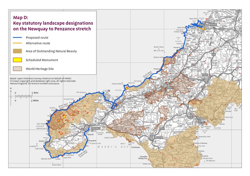
3. Understanding the proposals and accompanying maps
Before looking at the proposals and accompanying maps, it will help you if you read the following notes and
then look carefully at the key to the maps.
Our Proposals:
The proposals are divided into 8 reports, each relating to a particular length of coast on this stretch. Each
report is accompanied by detailed maps of the relevant length of coast. The maps are numbered according
to the report to which they relate. For example, maps NQP 1a to NQP1i illustrate the proposals described in
report NQP 1.
Each report comprises four parts:
Part 1: Introduction – This sets the context for our proposals for that length of coast.
Part 2: Proposals Narrative - This summarises our alignment proposals in general, including any
proposed use of our discretions to align the route along an estuary, or recommended changes to the
default landward coastal margin. It also summarises the main access management measures that
will need to be introduced and the overall accessibility (ease of use for all) of this length of coast, for
all users. Additionally, it may identify any future changes of which we are aware that are likely to
impact on this part of the coast, and explain how our proposals deal with this change. In each report
the Part 2 Proposals Narrative, in conjunction with the Part 3 Proposals Tables and the Part 4
Proposals Maps, sets out our formal proposals to the Secretary of State in relation to the length of
coast in question, for which we are seeking approval under section 52 of the National Parks and
Access to the Countryside Act 1949.
Part 3: Proposals Tables – These line-by-line listings set out in more detail our formal proposals to
the Secretary of State for the length of coast in question, and should be read in conjunction with the
Proposals Narrative and the relevant Proposals Maps.
Part 4: Proposals Maps – These show in map form the proposals set out in the Proposals
Narrative and Proposals Tables.
Notes on how our Part 3 Proposals Tables work
These notes explain how the various tables found in each report work:
In the table for sections of the trail that follow the existing South West Coast Path as currently
walked and managed, we set out detailed information for each section of coast under the following
column headings:
Map(s) – This column indicates which of the report maps to view alongside the details in the
other columns in the same row.
Route section number(s) – This is the unique identification number for the route section
concerned. In some cases, two or more adjacent route sections will be amalgamated into a
single row in the table, if all other displayed details happen to be identical.
Roll-back proposed? – This indicates whether we propose that, in the event of significant
coastal erosion or other geomorphological processes or significant encroachment by the sea, a
section of trail which is affected by such factors should be capable of being repositioned in the
future in accordance with this formal proposal, without needing further confirmation of the
change at that time by the Secretary of State. Roll-back may be used to adjust the trail either in
direct response to such changes or in order to link with other parts of the route that need to roll
back in response to such changes. The column also indicates whether the ‘roll-back’
requirement is likely to give rise to a normal or more complex change on this section. (In the
8 England Coast Path | Newquay to Penzance | Overview
case of more complex outcomes, further details are provided in the ‘Roll-back implementation’
table). Section 4.10 of the Coastal Access Scheme explains in more detail how roll-back works.
Landward margin contains default coastal land type? – Certain coastal land types are
automatically included in the coastal margin where they fall landward of the trail if they touch it at
some point. These coastal land types are: foreshore, cliff, bank, barrier, dune, beach, flat or
section 15 land. This column identifies where one of the coastal land types is present in the
landward coastal margin.
Proposal to specify landward boundary of margin – This sets out any proposals for the default
landward boundary of the coastal margin on this section to be altered or clarified - see iv below
in the Notes on Maps.
Reason for any proposed use of landward boundary discretion – This provides an explanation
for any such proposal to alter or clarify the default margin on this section. This may be either
because we are proposing a clear boundary around land that in our view would be margin by
default, because it matches the description of ‘coastal land’ explained at paragraph 4.8.8 of the
Scheme; or because we propose using our discretion to add land to or remove it from the default
margin, as described at paragraphs 4.8.11 of the Scheme.
Explanatory notes – This contains any additional information which may help further explain the
proposal for this route section or group of sections.
In the table for sections of the trail that differ from the existing South West Coast Path as currently
walked and managed, we set out additional information for each section of coast under the following
column heading:
Current status of route section(s) – This describes the current status of the route we have
proposed and whether it has any existing access rights. Public highways, including public rights
of way such as footpaths, are excepted from new coastal access rights because the existing
public rights to use such highways will remain in force, and the trail is able to make use of these.
Other sections of the proposed trail that do not currently have any access rights or where access
is currently permitted by the landowner will become subject to new coastal access rights if our
proposals are approved. These new rights, and any national or local restrictions on them, will not
affect any existing access arrangements for cyclists, horse-riders or other types of recreational
user that may currently exist at the local level - for example by formal agreement with, informal
permission from or traditional toleration by the owner of the land, or through any type of pre-
existing legal right that remains in force.
Where there is an alternative route or optional alternative route we set out the details of those routes
in a separate table. The table includes columns that describe the landward and seaward boundaries
of the alternative route strip. Alternative routes/optional alternative routes have a default width of two
metres either side of the approved line. We propose specific landward and/or seaward boundaries to
the route strip where doing so would add further clarity to the extent of access rights along the route,
by working with the grain of what is already there. It should be noted that where the alternative
route/optional alternative route follows an existing path corridor, the trail may adopt a variable width
as dictated by existing physical features.
Each report also includes a table that sets out any other options that were considered during our
initial planning (in relation to the route and the coastal margin), and explains why they did not form
part of our proposals.
The final table or set of tables for each report provides further details of any situation where local
circumstances mean that implementation of roll-back is likely to be more complex. We identify the
key issue and our expected resolution.
9 England Coast Path | Newquay to Penzance | Overview
Annotated examples of these various tables are given below, to illustrate how they are used.

In each report the Part 3 Proposals Tables, in conjunction with the Part 2 Proposals Narrative and the Part
4 Proposals Maps, set out our formal proposals to the Secretary of State in relation to the length of coast in
question, for which we are seeking approval under section 52 of the National Parks and Access to the
Countryside Act 1949.

Examples of tables found in each report, with explanation of their contents:

Note that for the tables for sections of the trail that follow the existing South West Coast Path as currently
walked and managed, the column ‘Current status of route section(s)’ has been omitted.

Example table 1: Section details

10   England Coast Path | Newquay to Penzance | Overview
Example table 2: Alternative routes and optional alternative route details

Example table 3: Other options considered

11   England Coast Path | Newquay to Penzance | Overview
Example table 4: Roll-back implementation – more complex situations

12   England Coast Path | Newquay to Penzance | Overview
Notes on how our Part 4 Proposals Maps work
The notes that follow will help explain the maps provided for each report.
The proposed route of the trail:
i The thickness of the line used to depict the proposed route on the maps is intended to make it easy
to find on the map and to enable us to differentiate, by shading the line differently, between sections
of the route that would use existing rights of way, sections that appear to follow other existing
walked lines on the ground, and sections that do neither. The thickness of the line on the map is not
an indication of the width of the actual trail on the ground – the proposed route simply follows the
centre of the line shown. The legislation makes the default width of the trail four metres, but its
actual width varies a good deal in practice according to the detail included section by section in our
proposals.
ii In places there are differences between the line of public rights of way recorded on the local
Definitive Map that is maintained by the local highway authority, and paths currently used and
managed on the ground as public rights of way. Some of these differences may be attributed to
adaptation of the path over time to cope with coastal erosion and other processes, whilst others
appear to arise from anomalies in the way the rights were originally recorded on the definitive map.
The maps in this report show the public rights of way as recorded on the definitive map, and depict
them as accurately as possible at the scale used. See part 4.7 of the Scheme for further information.
The coastal margin:
iii The proposed route of the trail shown on the maps is important in understanding the extent of the
coastal margin that would apply to either side of it. Under the legislation:
the coastal margin is a single, continuous corridor of land which includes the trail itself;
the margin includes all land seaward of the trail land - although not all of that land would be
subject to a new right of access (see point vi below);
the landward extent of this margin is by default the trail itself, or the inland edge of any land
adjoining the trail on its landward side that is foreshore, cliff, dune or beach, or a bank, barrier or
flat, or section 15 land (see Annex B: Glossary of terms).
iv We have the discretion to propose that the landward boundary of the coastal margin should coincide
with a recognisable physical feature on the ground – even if the effect of doing so is to add land into
the margin, or to remove land from it. We may use this discretion:
to propose that instead of the default trail width of four metres set by the legislation, particular
physical features such as walls, fences or pavement edges should be used where appropriate to
define the landward extent of the trail land on that section of the route: such features cannot be
depicted on the maps at the scale used, but they are described in the Proposals Tables;
to clarify or adjust the boundaries of a landward area included by default as margin, in order to
create a better ‘fit’ with the circumstances on the ground; or
to propose in some places that additional areas of land should be added to the coastal margin
landward of the trail: land which is affected by such proposals is indicated on the maps with a
purple wash and described in parts 2 and 3 of each report.
Further explanation of these powers can be found at part 4.8 of the Coastal Access Scheme. Our
proposals take full account of any views expressed by the owner or occupier of affected land about
whether the powers should be used in any of these ways.
13 England Coast Path | Newquay to Penzance | Overviewv Land which forms part of the coastal margin would be subject to access rights, other than:
any excepted land, such as land covered by buildings or their gardens or curtilage: Annex C
summarises in full the categories of excepted land under the legislation; or
any land where coastal access rights would be excluded under our statutory powers: we
indicate in the report where we already know of circumstances that make this necessary, and
make any proposals accordingly.
vi Spreading room is the term used in the reports to describe any land, other than trail land, which
would form part of the coastal margin and would have public rights of access. It does not therefore
include any excepted land within the margin, or any existing access land on the landward side of the
trail that is omitted from the margin.
Annex B (Glossary of terms) includes a full definition of these terms which you may find helpful in
understanding the report.
Voluntary access dedication
vii Land that was previously dedicated as access land under section 16 of the Countryside and Rights
of Way Act 2000 (CROW) will become subject to the coastal access regime if it forms part of the
coastal margin in any of the ways described above. There is also provision in the legislation for a
land owner or long leaseholder to dedicate other land voluntarily as coastal margin if it lies adjacent
to it or within it. Dedicating land as coastal margin disapplies the excepted land provisions within it,
and may also make provision for the removal or relaxation of specific national restrictions that
would otherwise apply. Parts 4.8.20 to 4.8.23 of the Coastal Access Scheme explain these
provisions in more detail.
In each report the Part 4 Proposals Maps, in conjunctions with the Part 2 Proposals Narrative and the Part
3 Proposals Tables, set out our formal proposals to the Secretary of State in relation to the length of coast
in question, for which we are seeking approval under section 52 of the National Parks and Access to the
Countryside Act 1949.
14 England Coast Path | Newquay to Penzance | Overview4. Preparation of the report
To secure the twin objectives under the legislation we have followed the approach set out in our Coastal
Access Scheme, as approved by the Secretary of State on 9 July 2013. Chapter 3 of this detailed document
sets out the stages of implementation we must follow.
In line with this, before making the proposals in this compendium of reports for the stretch, we conducted
extensive preliminary work in two main stages:
Stage 1: Prepare – defining the extent of the coastal stretch with access authorities and identifying
the key issues and opportunities, including sensitive features, in conjunction with key organisations;
and
Stage 2: Develop – checking the alignment on the ground, sharing our initial thoughts with land
owners and offering to ‘walk the course’ with them, planning for the protection of key features,
talking further with key interests and reality checking our proposals.
Stage 1 - Prepare
This stage involved us working closely with access authorities to develop an understanding of the stretch,
agree its exact extent and carry out initial familiarisation visits. We held discussions with representatives of
national and local organisations with a strategic interest in this stretch of coast. This included discussions
with those we are required by legislation to consult at this stage:
Cornwall Countryside Access Forum;
Cornwall Council and Cormac officers, including ecology, geology, historic environment, planning,
transport and countryside access staff;
the Environment Agency, in relation to flood defence and coastal erosion management on this
stretch of coast;
local officers of Historic England, in relation to historic features on this stretch of coast; and
the Ministry of Defence, in relation to defence interests on this stretch of coast.
We also held discussions with representatives of specific interest groups, including:
the South West Coast Path Association;
the Ramblers Association;
the British Mountaineering Council;
the National Farmers Union;
the British Association for Shooting and Conservation, and
the Country Land and Business Association.
We publicised on our website the start of work on the stretch and provided an opportunity for all other
interested parties to submit to us their views on local issues and opportunities.
We also engaged with internal specialists and relevant organisations locally - including Cornwall Wildlife
Trust, Royal Society for the Protection of Birds, Cornwall Seal Group and Cornwall Area of Outstanding
Natural Beauty - to consider any potential for impacts on key sensitive features.
In addition to these discussions we took into account a wide variety of information, plans and strategies that
we considered relevant to the alignment process. Those that are published on the internet are listed in
Annex A: Bibliography.
15 England Coast Path | Newquay to Penzance | OverviewWe then took all reasonable steps to identify owners, occupiers and those with a legal interest in the land which could be affected. Stage 2 - Develop This stage involved us contacting, and discussing our initial thoughts with relevant owners, occupiers and other legal interests. In places where the existing route of the South West Coast Path as currently walked and managed fitted well with the criteria for the walking route as set out in the Coastal Access Scheme, we wrote to relevant owners, occupiers and other legal interests to explain our emerging conclusions and to offer them an opportunity to talk to us about them. We also sent them a mapped summary of our emerging proposals, clearly explaining how their land would be affected by any new rights and seeking any views about this. On sections where there was the potential to make improvements to the existing route of the South West Coast Path to fit more closely with the criteria set out in the Coastal Access Scheme, we contacted relevant owners and occupiers and asked for their views so that we could discuss options for alignment. We also took reasonable steps to identify and contact any owners, occupiers or other legal interests who could foreseeably be affected in the future as a result of any roll-back that may prove necessary). See part 7 ‘Future Changes’ below. We then held further detailed discussions with internal and external specialists to refine our thinking on protecting key sensitive features, carrying out any necessary assessments. After further discussions with key local and national organisations we refined our proposals and checked them on the ground before moving onto Stage 3 – Propose, which is the substance of these reports. 16 England Coast Path | Newquay to Penzance | Overview
Key issues along this stretch
5. Discretion to include part or all of an estuary or estuaries
The proposed Newquay to Penzance stretch includes part of the estuaries of the rivers Gannel and Hayle.
a) Introduction
This part of the Overview:
introduces the core statutory duties and considerations for the national programme as a whole in
relation to exercising the discretion to include part, or all, of an estuary within our proposals;
describes the overall nature of the estuary systems found in this part of England, identifying the
geographical limits of our discretion to align the trail around the estuaries of the River Gannel and
the River Hayle included within this stretch of coast;
goes on to explain in more detail how each of the specific estuary considerations set out at section
301 of the 2009 Act affects our view of the options for the Gannel and Hayle estuaries;
sets out the options for estuary trail alignment which we have identified as a result of this analysis,
and;
describes and explains our chosen proposal in each case.
b) Estuary discretion
Under the 2009 Act there is no requirement for the trail to extend up any estuary further than the seaward
limit of estuarial waters that is explained below under “Geographical limits of our discretion”.
But Natural England has a discretion to propose that the trail should extend from the seaward limit as far as
the first bridge over which, or tunnel through which, there is a public right of way, or a public right of access,
by virtue of which the public are able to cross the river on foot, or as far as any specified point in between.
In exercising its discretion, Natural England must have regard to the core national duties and considerations
described in Part B and Chapter 10 of the Coastal Access Scheme.
c) Core national duties and considerations relevant to estuaries
Section 296 of the 2009 Act places a legal duty (the Coastal Access Duty) on Natural England and the
Secretary of State to secure a walking route around the whole of the open coast of England, together with
an associated margin of land for the public to enjoy either in conjunction with their use of the route, or
otherwise.
Section 297 goes on to require both, in discharging this duty, to have regard among other things to the
desirability of ensuring that so far as reasonably practicable, interruptions to this route are kept to a
minimum. This is a key consideration for the whole of the national delivery programme for coastal access.
The whole concept of the England Coast Path relies on delivering continuity of the route so far as
reasonably practicable for the whole country. Although proposing a route around each estuary is a
discretion rather than a legal duty, if the presence of an estuary would interrupt this continuity of access
along the open coast then this will constitute a strong prima facie reason for the trail to serve the estuary
too, at least to the extent necessary to enable users to continue their onward journey around the coast.
The Scheme notes at paragraph 10.1.4 that because the seaward limit of estuarial waters is an arbitrary
point from an access perspective, we are likely to use our discretion at most estuaries to extend the trail
upstream to a more convenient point than this seaward limit. Paragraph 10.1.5 then adds “We will always
17 England Coast Path | Newquay to Penzance | Overviewgive careful consideration to our option to extend the trail as far as the first bridge or tunnel with pedestrian public access” – both for reasons of continuity, and with a view to any additional recreational benefits that might result within the estuary itself from doing so. Chapter 10 of the Scheme explains the statutory estuary criteria that section 301(4) of the 2009 Act requires to be taken into account in deciding whether or not to include an estuary in our proposals. These are discussed in more detail in subsections e) and f) below in relation to the Gannel and Hayle estuaries. The other key considerations, including achieving a fair balance with the interests of owners and occupiers, are discussed in part 6 of this Overview. d) Overall nature of estuary systems in this part of England The estuary systems on this stretch of coast form part of an extensive collection of estuaries in Cornwall. The Gannel flows from its source at Indian Queens in mid Cornwall and empties into the Atlantic Ocean to the south west of Newquay. At its mouth it separates the town of Newquay from the village of Crantock with its popular beach backed by sand dunes. The River Hayle is approximately 19km long, rising near the village of Crowan before meandering west close to Mount’s Bay and then north towards St Erth. Hayle estuary is popular with leisure users and is home to a historic working harbour with its own small fishing fleet. On the south-western side of the estuary is a large expanse of mudflat which is an important roosting and feeding location for a variety of wildfowl and waders. e) Gannel estuary Geographical limits of our discretion The seaward limit of the estuarial waters of the Gannel runs between the headlands of Pentire Point East and Pentire Point West. The statutory estuary criteria We have considered below each of the section 301 criteria under the headings given in Chapter 10 of the Scheme. i) Ferry services There is a seasonal ferry service running across the Gannel between Riverside Crescent and Crantock Beach. The Fern Pit Ferry operates from the end of May to mid-September between 9.30am and 6pm when the tide is in (approximately 3 hours either side of high water); ii) Character of the Estuary Estuary width At its seaward limit the Gannel estuary measures approximately 760m, widening slightly towards Crantock beach giving a feel of the open coast. East of the beach the estuary narrows to a channel of between 80m and 250m, reducing to around 25m at Trevemper Bridge. Topography of the shoreline The estuary consists of a main channel with one main inlet on its southern side – the Penpol Creek. Much of the bed of the river is exposed at low tide, with saltmarsh and mudflat revealed shortly after high tide in the area either side of the Trenance footbridge. 18 England Coast Path | Newquay to Penzance | Overview
At the mouth of the estuary Crantock Beach is bordered by tall sand dunes to the south east and steep cliff
and rocks to the north.
Nature of affected land
The northern side is composed of cliffs and coastal slope near the mouth of the estuary and has a distinctly
coastal feel. Moving eastwards the land is more developed consisting of houses and gardens with some
open areas of grassland and paths to the shore in places.
To the south the landscape is mostly open farmland with some woodland closer to the estuary. The majority
of the river bed is exposed at low tide with intertidal areas of saltmarsh and mud flat revealed to the east
shortly after high tide.
Features of interest
Newquay is a very popular leisure destination with visitors, particularly during the summer. It has a lively
centre with shops, cafes and bars and is host to a variety of festivals and sporting events often based on
and around the town’s beaches.
To the south west of the town the headland of Pentire Point East provides panoramic views over Newquay
and Fistral Beach and offers a unique viewpoint towards the beach and dunes of Crantock.
On the northern bank of the estuary is the site of the Gannel Boatyard where 20 large sailing vessels were
built during the mid to late 19th century when the estuary was still able to be navigated by schooners and
lighters.
On the southern side of the estuary at Penpol Creek there is evidence on the shoreline of its history as a
port where goods were landed and taken further upstream by packhorse or cart. The quay, steps and
mooring rings can still be seen on the wooded western shoreline at low tide.
iii) Recreational Benefit
Newquay is the largest settlement on the north coast of Cornwall with good transport links and a diverse
range of local services. It is a popular tourist destination, particularly during the summer months, with a
number of beaches and visitor attractions accessible from the town. Crantock Beach to the south of the
Gannel estuary, is popular with families and water sports enthusiasts.
Access in the area is generally good, with the South West Coast Path National Trail providing various
routes to cross the estuary by foot depending on the state of the tide. As a promoted route the England
Coast Path could provide a continuous, well waymarked route around the estuary, using a combination of
permissive routes, residential roads and Public Rights of Way.
iv) Excepted land
Much of the northern shore is likely to be excepted land, consisting of private houses and gardens. On the
southern side, the landscape is mostly open with some woodland closer to the estuary and there is unlikely
to be much land excepted from the coastal access rights.
v) Options for Gannel estuary
Option 1 – Align the trail as far as the seaward limit of the estuarial waters. Walkers would have an
interrupted journey along the England Coast Path and would have to navigate themselves between
Pentire Point East and Pentire Point West.
Option 2 – Use our discretion to align the trail as far as the Fern Pit Ferry (approximately 1km from
the seaward limit) where walkers can cross the estuary between Riverside Crescent and Crantock
Beach by means of the seasonal, high tide ferry. The ferry operates from the end of May to mid-
September between 9.30am and 6pm approximately 3 hours either side of high water.
19 England Coast Path | Newquay to Penzance | Overview Option 3 – Use our discretion to align the trail as far as the Penpol boardwalk where walkers can
cross the estuary from the northern bank seaward of Penmere Drive to Penpol via the tidal
boardwalk. The boardwalk is unavailable 3 hours either side of high tide. This route would involve an
additional walk of 2.4km from the point of the ferry crossing.
Option 4 – Use our discretion to align the trail as far as the Trenance footbridge where walkers can
cross the estuary from Gannel Road on the northern side to the southern bank seaward of
Treringey. The footbridge is unavailable 1.5 hours either side of high tide. This route would involve
an additional walk of 3km from the point of the Penpol boardwalk.
Option 5 – Use our discretion to align the trail as far as Trevemper Bridge and follow the existing
high tide route to Penpol. This route would involve an inland diversion and additional walk of 3km
from the point of the Trenance footbridge.
Option 6 – Use our discretion to align the trail as far as the Fern Pit Ferry and align an alternative
route over Trevemper Bridge which would come in use at times when the ferry is not operating. The
alternative route would be long at 7.5km and walkers joining the path away from the ferry may have
difficulty establishing when the alternative route is formally open. It would also deny the public the
opportunity to enjoy suitable areas of spreading room and would not offer any improvements to
existing access around the estuary.
Proposed route of the trail
Our proposal is to align the trail over the Trenance footbridge (Option 4) via public highways, public rights of
way and a short section of private road. This route is available year-round at all states of the tide apart from
1.5 hours either side of high tide. An optional alternative route is proposed for use at high tide when the
other crossing points are unavailable. This fulfils the core objective of the legislation ‒ to create a
continuous route around the coast ‒ in a simple and cost effective way. Our proposal varies slightly from
the existing South West Coast Path routes as signposted on the ground by taking a more seaward route on
both sides of the estuary. See report NQP 1 for more details.
20 England Coast Path | Newquay to Penzance | Overview21 England Coast Path | Newquay to Penzance | Overview
f) Hayle estuary
Geographical limits of our discretion
The seaward limit of the estuarial waters of the Hayle estuary coincides with Carrack Gladden to the west
and Black Cliff to the east of the estuary.

The statutory estuary criteria
We have considered below each of the section 301 criteria under the headings given in Chapter 10 of the
Scheme.

i) Ferry services
There is no ferry service across the Hayle estuary.

ii) Character of the Estuary
Estuary width
The Hayle estuary is at its widest at the seaward limit measuring almost 2km and is characteristic of open
coast. The channel narrows to around 100m between Lelant and Harvey’s Towans. Further upstream a
sand spit divides the east and west sides of the river with the channel to its west reducing to approximately
65m.

Topography of the shoreline
The Hayle estuary consists of a main channel divided by a sand spit and contains other tidal areas
including Copperhouse Pool, part of Carnsew Pool and the mudflats of the RSPB reserve.

The eastern side of the shoreline is largely built up consisting of the harbour area and its various quays.

To the south and west of the estuary the expanse of mudflats making up the RSPB reserve supports up to
18,000 migrant and wintering waterfowl.

Nature of affected land
Areas around the mouth of the estuary are strongly characteristic of the coast with large expanses of
foreshore backed by dunes. Moving upriver, the town of Hayle dominates the eastern side of estuary with
the working harbour areas of North, East and South Quays.

To the south east is an enclosed tidal area known as Carnsew Pool, and adjacent to this at the south
western corner of the estuary, are the saltmarsh and mudflats of the RSPB reserve providing a distinctly
coastal feel to the area.

The western side of the estuary is composed of houses, gardens, a large car park, football ground, small
quay area and West Cornwall Golf Club. A railway line flanks the shoreline for most of the length of this side
of the estuary.

Features of interest
The Port of Hayle is part of the Cornwall and West Devon Mining Landscape World Heritage Site. Hayle
was predominately shaped by the mining industry and the Industrial Revolution of the eighteenth and
nineteenth centuries. The settlement was an internationally important mining port, the global centre for
steam engine manufacturing, and home to two large iron foundries serving the mining industry locally and
across the world. Evidence of this industry still exists throughout the town and is of considerable historical
significance. Hayle Harbour still operates today with a small fishing fleet, and many leisure boats visiting the
area.

22   England Coast Path | Newquay to Penzance | Overview
The RSPB Hayle Estuary Reserve covers a large part of the estuary and comprises intertidal areas of
saltmarsh, mudflat, sand and the tidal areas of Copperhouse Pool and Carnsew Pool. It is the most south-
westerly estuary in the UK and provides important feeding and roosting habitat for wintering waterfowl, gulls
and waders.
iii) Recreational Benefit
It is currently possible to walk around the estuary along the South West Coast Path National Trail which
uses roads or public rights of way for most of the length.
Hayle is a centre for tourism with a number of holiday parks situated in the extensive dunes to the north of
the town, and other accommodation closer to the town centre. There are large beaches on both sides of the
estuary at Hayle Towans to the east and Porthkidney Sands on the western side. The area is popular with
birdwatchers drawn to the RSPB Hayle Estuary reserve and the many wetland birds visible from the coast
path.
The railway line between St Erth and St Ives travels along the western edge of the estuary for most of its
length, linking up smaller settlements of Lelant and Carbis Bay. The route of the South West Coast Path
passes close to all the stations on this branch line, excluding St Erth, providing an opportunity to combine a
coastal walk with a scenic train journey.
As a promoted route the England Coast Path could provide a continuous, well waymarked route around the
estuary, using a combination of highways, permissive routes, and Public Rights of Way.
iv) Excepted land
The eastern and southern sides of the estuary are bordered by the town of Hayle. The route of the South
West Coast Path passes close to the estuary apart from at West Quay and South Quay, where there are
areas occupied by commercial and domestic buildings. There are also areas of the working harbour where
statutory undertakings take place which would be excepted from coastal access rights.
On the western side of the estuary the railway line between St Erth and St Ives runs close to the edge of
the estuary for most of its length. Landward of the railway line the land is mostly occupied by houses and
gardens, with a large car park and St Ives Town football ground at Lelant Saltings. At Lelant the railway
passes across a golf course with playing areas to both the seaward and landward sides.
v) Options for Hayle estuary
Option 1 – Align the trail as far as the seaward limit of the estuarial waters. Walkers would have an
interrupted journey along the trail and would have to navigate themselves between Black Cliff and
Carrack Gladden.
Option 2 – Use our discretion to align the trail around the edge of the estuary to the first bridges
(between North Quay and Hayle Terrace and along The Causeway) using existing walked routes,
highways and public rights of way. The route around the estuary measures approximatively 8km
from the seaward limit.
Proposed route of the trail
Our proposal is to align the trail around the estuary (Option 2), following, for the most part, the route of the
South West Coast Path National Trail. This fulfils the core objective of the legislation ‒ to create a
continuous route around the coast ‒ in a simple and cost effective way. The route differs slightly from the
South West Coast Path route at North Quay and South Quay. See report NQP 4 for more details.
23 England Coast Path | Newquay to Penzance | Overview24 England Coast Path | Newquay to Penzance | Overview
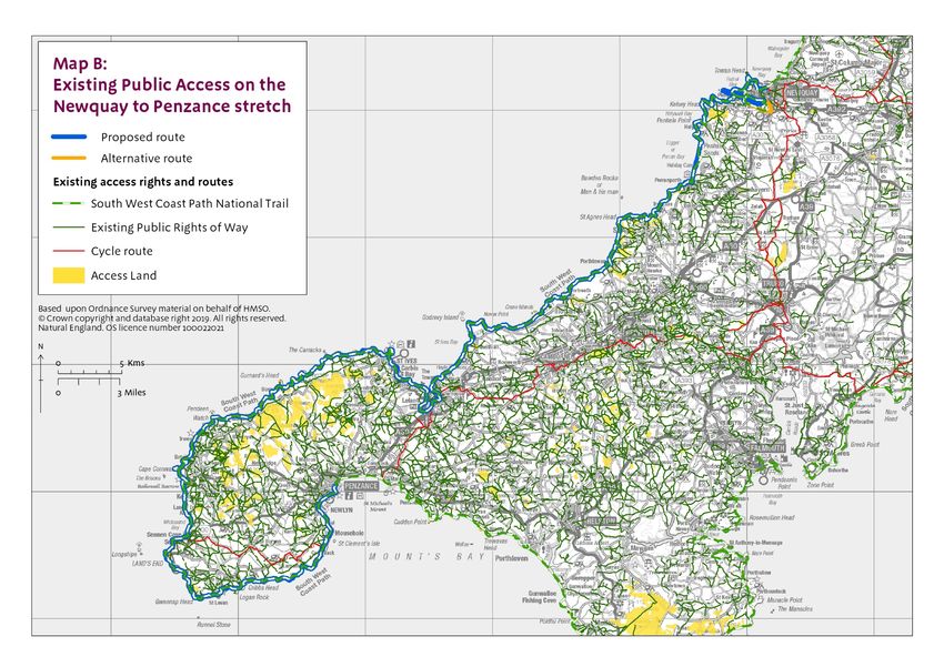
6. Other considerations on this stretch
a) Recreational Issues

Map B gives an overview of existing public access to the Cornish coast between Newquay and Penzance
showing public rights of way, access land and the South West Coast Path National Trail along the stretch.

Our proposals will supplement the ambitions described in the Cornwall Countryside Access Strategy by
enhancing provision of access at the coast.

The South West Coast Path already affords good linear coastal access throughout this stretch of coast. For
the most part it maintains relatively close proximity to the sea, with access to the shoreline in many places.

The proposed route of the trail would follow much of the route currently managed as the South West Coast
Path National Trail, however there are places where it differs from that route which are shown on the maps
accompanying each report. If the Secretary of State approves our proposed route for the England Coast
Path along this length of coast, we propose to modify the approved route of the existing national trail to
coincide with the proposed route for the England Coast Path in places where the two diverge. This is
achieved by means of a separate variation report to the Secretary of State.

The majority of the northern coast of this stretch between Perranporth and Land’s End is designated as
open access land, apart from the area between Gwithian and Clodgy Point. On the south coast there is
open access land between Land’s End and Penberth with a smaller area around Lamorna. These areas are
shown as existing access land on Map B where possible at the scale of the map, and in more detail in the
maps that accompany each report. There are no existing open access rights to the south coast between
Penberth and Penzance.

All land seaward of the proposed route, and certain coastal land types that are landward of it, would
become coastal margin by default if our proposals are approved. The coastal margin would normally be
subject to access rights unless it is excepted land or excluded by direction (see the section in part 3 of the
Overview entitled ‘Notes on how our Part 4 Proposals Maps work’). This would extend access rights much
more widely than at present along the south coast of this stretch and replace the existing access land
seaward of the trail.

Where existing access land would not qualify as coastal margin in the ways described above, we have in
some places proposed that it should be included using our discretion to propose a physical feature as the
landward boundary of the coastal margin. The majority of this landward spreading room is owned by
Cornwall Council or the National Trust. The individual reports give details of all such proposals for coastal
margin landward of the trail and the detailed maps show the extent of each. These proposals are in all
cases made with the agreement of the landowner.

The main issues highlighted to us in discussions with user groups and the Cornwall Countryside Access
Forum were about sections of the South West Coast Path that are not in close proximity to the sea. We
have considered these in our proposals, and, where we have not been able to address them, explained the
reasons clearly in the relevant reports.

b) Protection of the environment

The coastline between Newquay and Penzance is highly designated for its landscape, wildlife and cultural
heritage assets.

Two Marine Conservation Zones (MCZ) are situated on this stretch of coast ‒ Newquay and the Gannel
MCZ and Runnel Stone MCZ. The Land’s End to Cape Bank Special Area of Conservation (SAC) lies to the

25   England Coast Path | Newquay to Penzance | Overview
west of the Land’s End peninsula, Godrevy Head to St Agnes Head SAC is notified for species such as
early gentian and the Penhale Dunes SAC is centred on the largest sand dune site in Cornwall.

Numerous Sites of Special Scientific Interest (SSSI) are situated along the coast between Pentire Point
West and Newlyn. Notable vascular plants include Slender Birds Foot Trefoil and Yellow Bartsia with
species such as kittiwake and grey seal also present in some places. On the south coast the SSSIs are
mostly notified for their geological features. See Map C: Key statutory environmental designations on the
stretch.

The majority of the rural coast of this stretch forms part of the Cornwall Area of Outstanding Natural Beauty.
Parts of the northern and western coast are well known for their history of mining with evidence of this
activity still present in the landscape. These areas are included in the Cornwall and West Devon Mining
Landscape World Heritage Site. There are also a number of Scheduled Ancient Monuments along the
coast. See Map D: Key landscape designations on the stretch.

The landscape of this stretch is varied. The north coast is generally more dramatic and is characterised by
tall cliffs, open coastal plateau and rugged headlands. There are wide expanses of beach backed by
extensive dunes at Crantock, Perranporth and between Gwithian and Hayle. Hayle is home to the most
south westerly estuary in the UK and is an important site for a variety of wading birds. Various settlements
separate areas of the rural northern coast, including the popular visitor destinations of Newquay and St
Ives.

The south coast is home to sheltered coves, such as Penberth and Lamorna, and the harbour towns of
Mousehole and Newlyn. In between these settlements the landscape is mostly farmed with the steeper
areas of coastal slope left ungrazed. The largest settlement on the south coast of this stretch is the town of
Penzance.

Tourism is a major contributor to the economy of this stretch with visitors drawn to the coast and the various
attractions and holiday parks. Recreational activities include walking, cycling and water based pastimes
such as surfing and sailing.

As a result of the proposals described in this Overview and associated reports for each length of coast, the
quality of coastal paths will be improved and there will be greater certainty and clarity about the rights
people have within the coastal margin. Use of the coast for outdoor recreation can, if not carefully
managed, add to environmental pressures such as the presence of people causing disturbance to wildlife or
new paths leading to removal and fragmentation of habitat. Part of the process we go through on each
length of coast when we are developing our detailed proposals is about finding ways to avoid or reduce
such impacts, and ensure compliance with legislation to protect the environment.

In developing our detailed proposals for coastal access we have taken account of environmental protection
objectives and these are, where relevant, discussed in more detail in the relevant report for each length of
coast and the following documents that we have published separately:

A single Habitats Regulations Assessment (www.gov.uk/government/publications/england-coast-path-from-
newquay-to-penzance-comment-on-proposals) relating to any potential impact on the conservation
objectives of affected sites from the proposals we make in each report for the stretch. This assessment
considers any potential impacts in relation both to the individual length of coast covered by each report, and
to the stretch as a whole.

Our Nature Conservation Assessment (www.gov.uk/government/publications/england-coast-path-from-
newquay-to-penzance-comment-on-proposals) for the stretch, in which we document our conclusions in
relation to any other potential impacts on nature conservation.

26   England Coast Path | Newquay to Penzance | Overview
You can also read