Volume I - Non-Technical Summary of Environmental Impact Assessment Report
←
→
Page content transcription
If your browser does not render page correctly, please read the page content below
Volume I - Non-Technical Summary of
Environmental Impact Assessment Report
                     Proposed Residential Development
    Lands West of Old Belgard Road and North, South & West of
Cookstown Road, Cookstown Industrial Estate, Tallaght, Dublin 24

         Joseph Costello, Absolute Limousines Ltd and Boherkill Property
                                                      Development Ltd.

                                                           February 2021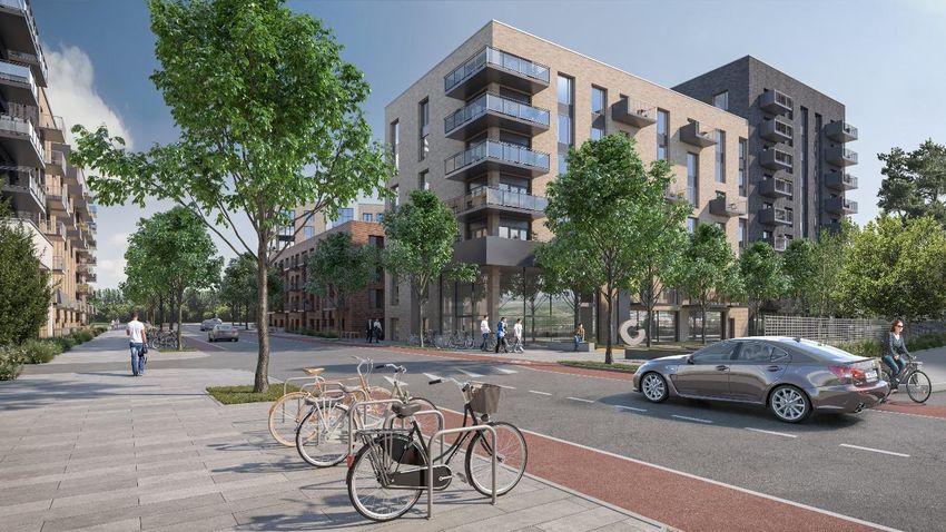
EIAR Non-Technical Summary                                                                             ___________________

Preface

The Applicants, Joseph Costello, Absolute Limousines Ltd and Boherkill Property Development Ltd,
has acquired the subject land) with the intention of securing the optimum land use on these underutilised
sites within the Cookstown Industrial Estate. The Cookstown Industrial Estate is an area identified for
‘regeneration’ in the South Dublin County Development Plan 2016-2022 and is expected to be the
subject of extensive urban renewal in the coming years.

The design of the subject proposal has evolved during the planning process in response to the feedback
received at S247 pre-planning consultations with South Dublin County Council and SHD pre-planning
consultations with An Bord Pleanala; the policies and objectives outlined in the Tallaght Town Centre
Local Area Plan 2020-2026 and South Dublin County Development Plan 2016-2022; and the input of
the Environmental Impact Assessment team.

The proposed development comprises of a 4-11 storey mixed-use development, comprising 1,104 no.
Build-to-Rent’ residential apartments, 4 no. commercial units, 1500sqm of office space and a creche.
The proposed development will result in a highly accessible and sustainable modern high-quality urban
residential neighbourhood having regard to the design/quality of the development proposed as well as
the employment opportunities existing in the surrounding area and the sites proximity to multiple public
transport services, the Tallaght Town Centre and a public open space area proposed immediately
south-east under the Tallaght Town Centre Local Area Plan 2020-2026. The proposed development
will improve greatly upon the existing industrial context, as illustrated in the images included below
(images of the existing built environment shown on the left and verified view montages of the proposed
development on the right).

Lands West of Old Belgard Road and North, South & West of Cookstown Road, Cookstown Industrial Estate, Dublin 24      i
EIAR Non-Technical Summary                                                                             ___________________

1.0             Introduction

This Non-Technical Summary (NTS) of the Environmental Impact Assessment Report (EIAR) relates to
a Planning Application by Joseph Costello, Absolute Limousines Ltd. and Boherkill Property
Development Ltd. (referred to as the Applicant throughout) for a proposed strategic housing
development comprising the demolition of the existing industrial units on site (save for the for the
existing Circle K petrol station) and the construction of a mixed use development featuring 1104 no.
‘build-to-rent’ apartments with ancillary resident facilities, 4 no. commercial units (totalling 762sqm),
1,500sqm of office space and a 245sqm crèche, in 4 no. blocks varying in height from four to eleven
storeys; road, junction and streetscape upgrade works along First Avenue, Cookstown Road and Old
Belgard Road, including the installation a signalized junction at the intersection of First Avenue and
Cookstown Road and Old Belgard Road and Cookstown Road; construction of 3 no. new roads and 1
no. pedestrian/cycle link to the Belgard Luas Stop; and construction of a public plaza in the south-
western corner of the site on lands west of Old Belgard Road and north, south & west of Cookstown
Road, Cookstown Industrial Estate, Tallaght, Dublin 24.

Article 5(1)(e) of the EIA Directive requires that an Environmental Impact Assessment Report (EIAR) is
accompanied by a NTS of the EIAR and it is transposed into Irish law under article 94(c) of the Planning
and Development Regulations 2001, as amended.

This NTS presents a general overview of the proposed residential development and of associated
potential environmental impacts. The term ‘non-technical’ indicates that this summary is intended for
the educated lay person but avoids the use of technical terms, the presentation of detailed data and
complex scientific discussion, that detail is presented in Volume II of the EIAR.

2.0             Environmental Impact Assessment Requirements

The European Union (Planning and Development) (Environmental Impact Assessment) Regulations
2018, defines an EIAR as:

          ‘A report of the effects, if any, which proposed development, if carried out, would have on the
          environment and shall include the information specified in Annex IV of the Environmental
          Impact Assessment Directive.’

The subject development is not of a type or size that would require mandatory EIA under Annex I. With
respect to Annex II, the subject proposal would constitute an “infrastructure project” under Class 10.
Given the no. of units proposed, EIA is required under Class 10(b)(i) and Class 10(b)(iv). Class 10(b)(i)
relates to:

          “Construction of more than 500 dwelling units.”

In order to ensure that all potential impacts associated with the development proposal are identified and
addressed, this EIAR provides a systematic and integrated evaluation of the direct, indirect and
secondary effects of the project on the natural and socio-economic environment.

The aim of the approach is to identify and predict (for a given proposed development) any impacts of
consequence; to describe the means and extent by which they can be avoided in the first instance or
reduced or ameliorated; to interpret and communicate information about the impacts; and to provide an
input into the decision making and planning process.

The aim of the EIAR is to:

  •     Describe the project using information on the site, design and size of the proposed development;
  •     Identify and predict any impacts on environmental features likely to be affected, having regard to
        the specific characteristics of the proposed development;
  •     Describe the measures envisaged in order to avoid, reduce and, where possible, remedy
        significant adverse effects;
  •     Provide the data required to identify and assess the main effects which the proposed
        development is likely to have on the environment; and
  •     Provide a Non-Technical Summary of the information.

Lands West of Old Belgard Road and North, South & West of Cookstown Road, Cookstown Industrial Estate, Dublin 24      ii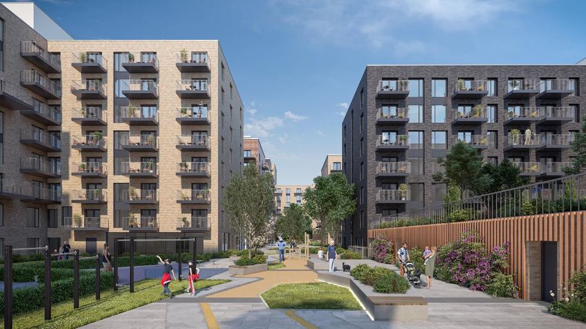
EIAR Non-Technical Summary ___________________
2.1 EIAR Study Team
The EIAR was completed by a project team led by Hughes Planning and Development Consultants,
who also prepared a number of the chapters.
The members of the team and their respective inputs are outlined below in Table 1.0 below.
In accordance with EIA Directive 2014/52/EU, we confirm that experts involved in the preparation of the
EIAR are fully qualified and competent in their respective field. Each has extensive proven expertise in
the relevant field concerned, thus ensuring that the information provided herein is complete and of high
quality.
Chapter No. Chapter Title Contributor
Chapter 1 Introduction Hughes Planning and
Development Consultants
(HPDC)
Chapter 2 Project Description and Alternatives Examined HPDC
Chapter 3 Planning and Development Context HPDC
Chapter 4 Population and Health HPDC
Chapter 5 Biodiversity Altemar Environmental
Consultants
Chapter 6 Land, Soils and Geology GDCL Consulting Engineers
Chapter 7 Water and Hydrology GDCL Consulting Engineers
Chapter 8 Noise and Vibration AWN Consulting Ltd
Chapter 9 Air Quality and Climate AWN Consulting Ltd
Chapter 10 Material Assets GDCL Consulting Engineers
and NRB Consulting Engineers
Chapter 11 Archaeology, Architectural and Cultural Courtney Deery Heritage
Heritage Consultancy Ltd
Chapter 12 Landscape and Visual Amenity Cunnane Stratton Reynolds
Chapter 13 Wind and Microclimate B-Fluid Ltd
Chapter 14 Interactions Between Environmental Factors HPDC in conjunction with
above consultants
Chapter 15 Principle Mitigation and Monitoring Measures HPDC in conjunction with
above consultants
Table 1.0 EIAR Chapters and Contributors
3.0 Project Description
3.1 Site Location and Context
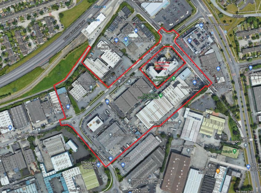
The subject application involves a large parcel of land west of Old Belgard Road and north, south &
west of Cookstown Road, Cookstown Industrial Estate, Tallaght, Dublin 24. The subject site comprises
an area of approximately 4.99Ha (12.3 acres). It includes a no. of existing industrial/commercial
premises fronting Cookstown Road, Old Belgard Road and First Avenue; the Circle K Belgard petrol
station and associated commercial premises; 0.98Ha of South Dublin County Council owned land; and
0.19 Ha of Dublin City Council owned land. The South Dublin County Council owned land comprises
parts of First Avenue, Cookstown Road and Old Belgard Road and the Dublin City Council owned land
comprises a strip to the north of Unit 5 First Avenue and Unit 4 Cookstown Road which provides access
to the Belgard Luas Stop. There are existing low-rise (1-3 storeys) industrial buildings featuring on the
subject site. These are proposed for demolition as part of the subject proposal.
The site is located within an area comprising industrial land use immediately east, west, south and north
(in part). The western part of the subject site’s northern boundary is flanked by an access road and
open space area featuring 110kV power lines. Further north, is the Red Luas line and Katherine Tynan
Road. In the context of the Red Luas Line, the subject site is immediately adjacent to the Belgard Road
Lands West of Old Belgard Road and North, South & West of Cookstown Road, Cookstown Industrial Estate, Dublin 24 iii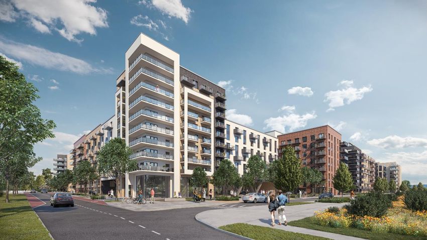
EIAR Non-Technical Summary                                                                             ___________________

Luas Stop which affords the subject site access to a high capacity high frequency modern public
transport service.

The area immediately surrounding the subject site is known as the Cookstown Industrial Estate and
features industrial and commercial land uses. The Cookstown Industrial Estate is expected to be the
subject of extensive urban renewal in the coming years, with existing industrial buildings being replaced
with higher density development and multi-national corporations, such as Amazon, commencing
operation in the area. Currently, the majority of the immediately surrounding buildings are older building
stock, save for a recently constructed 4-storey office building featuring at the Old Belgard Road and
Cookstown Road roundabout. However, a number of large scale residential and mixed-use
developments have been approved in the surrounding area in recent times.

Figure 1.0      Aerial image showing the application site (outlined in red) in the context of the immediate area

Figure 2.0     Existing view of the subject site as viewed from the intersection of Cookstown Road & First
               Avenue looking south-east (left) and Cookstown Road (north) looking south (right)

Lands West of Old Belgard Road and North, South & West of Cookstown Road, Cookstown Industrial Estate, Dublin 24      iv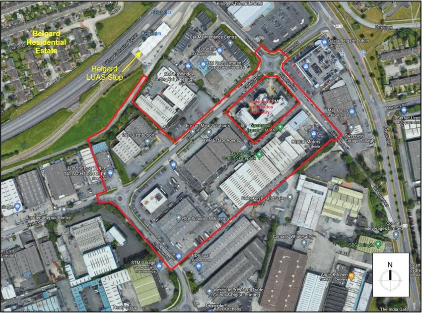
EIAR Non-Technical Summary                                                                             ___________________

Figure 3.0     Existing view of subject site as viewed from Cookstown Road (west) looking east (left) and
               Old Belgard Road looking west (right)

Figure 4.0     Existing view of subject site as viewed from the intersection of First Avenue and Cookstown
               Road, looking north (110kV power lines featuring in the background)

3.2             Proposed Development

The proposed development was strongly influenced by the policies and objectives contained in the
Tallaght Town Centre Local Area Plan 2020-2026, as well as national planning policy objectives and
requirements. The design team sought to achieve the following design principles and objectives in the
proposed development:

      •   Creation of a vibrant mixed-use residential-led self-sustaining neighbourhood served by high
          quality apartments, open space areas and services/facilities and featuring buildings of high
          quality in terms of architecture, design, visual interest, materials/finishes, energy efficiency and
          residential amenity;
      •   Promotion of walking and cycle through the provision of road, junction and streetscape upgrade
          works (consistent with the Design Manual for Urban Streets, 2019) along First Avenue,
          Cookstown Road and Old Belgard Road; cycle parking provision in excess of the requirements
          set out in the Sustainable Urban Housing: Design Standards for New Apartments Guidelines
          for Planning Authorities, 2018; and reduced car parking provision;
      •   Promotion of sustainable transport modes through the provision of a pedestrian/cycle link
          between Cookstown Road and the Belgard Luas Stop; improved access to the existing bus
          network as a result of the proposed road, junction and streetscape upgrade works; and the
          provision of car share facilities within the development;
      •   Improvements to the subject site’s and surrounding area’s legibility through the introduction of
          a new urban block structure and the provision of new streets to increase permeability through

Lands West of Old Belgard Road and North, South & West of Cookstown Road, Cookstown Industrial Estate, Dublin 24      v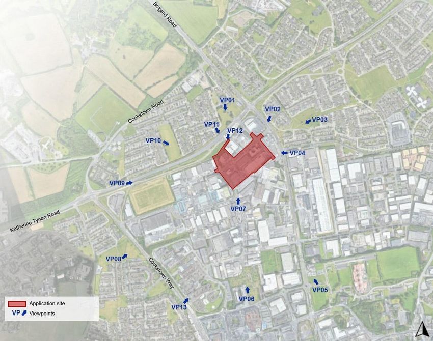
EIAR Non-Technical Summary ___________________
the site and links to nearby employment opportunities/facilities and services and to Tallaght
Town Centre, as well as the aforementioned road, junction and streetscape upgrade works;
and
• Adoption of the recommended mitigation measures prescribed by the EIAR team to limit/negate
potential environmental impacts; and
• Incorporation of appropriate setbacks from the 110kV power lines located immediately north.
The proposed development, as designed by C+W O’Brien Architects, involves the demolition of the
existing industrial units on site (save for the existing Circle K petrol station) and the construction of a
mixed-use development featuring 1104 no. ‘build-to-rent’ apartments with ancillary resident facilities, 4
no. commercial units (totalling 762sqm), 1,500sqm of office space and a 245sqm crèche, in 4 no. blocks
varying in height from four to eleven storeys, on the 4.99Ha site.
The development provides a total of 1,860 no. bicycle spaces, inclusive of 1464 no. spaces to serve
the proposed residents of the development and 396 no. spaces to serve the visitors. This, in addition
to the pedestrian links to the Belgard Luas Stop immediately north-east, will promote sustainable travel
among residents of the development and the surrounding area more broadly in the context of the
pedestrian/cycle links provided.
Further to bicycle parking, the development will be served by 351 no. parking spaces (including 17 no.
limited mobility parking spaces and 16 no. car share spaces), provided in 4 no. podium level car parks
(1 no. provided per block), in a car park provided south of the Circle K petrol station being retained on
site and on the street.
The proposed development also includes road, junction and streetscape upgrade works along First
Avenue, Cookstown Road and Old Belgard Road, including the installation a signalized junction at the
intersection of First Avenue and Cookstown Road and Old Belgard Road and Cookstown Road
construction of 3 no. new roads and 1 no. pedestrian/cycle link to the Belgard Luas Stop; and
construction of a public plaza in the south-western corner of the site.
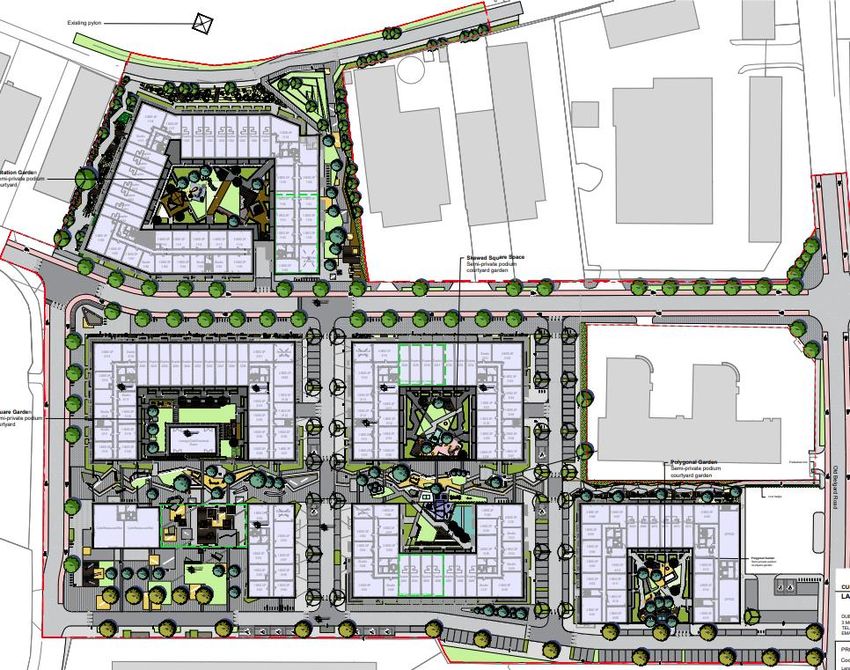
Figure 2.0 Site layout plan of proposed mixed use development
Lands West of Old Belgard Road and North, South & West of Cookstown Road, Cookstown Industrial Estate, Dublin 24 vi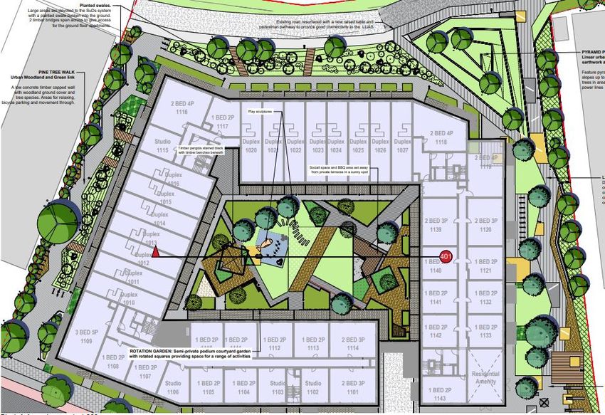
EIAR Non-Technical Summary                                                                             ___________________

Figure 3.0          Ground and first floor landscape masterplan for the proposed development

Figure 4.0          CGI of the proposed development

Lands West of Old Belgard Road and North, South & West of Cookstown Road, Cookstown Industrial Estate, Dublin 24      vii
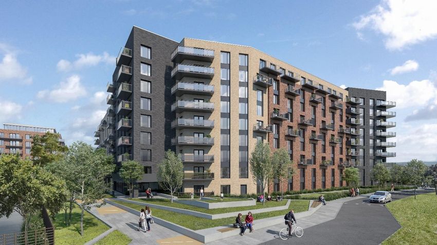
EIAR Non-Technical Summary                                                                             ___________________

Figure 5.0          CGI of the proposed development

Figure 6.0          CGI of the proposed development

Lands West of Old Belgard Road and North, South & West of Cookstown Road, Cookstown Industrial Estate, Dublin 24      viii
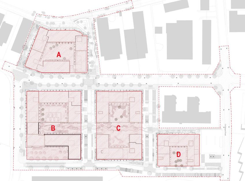
EIAR Non-Technical Summary                                                                             ___________________

Figure 7.0          CGI R5 of the proposed development

Figure 8.0          CGI R1 of the proposed development

The proposed development will be constructed in 4 no. phases commencing with Phase A immediately
adjacent to the Luas line and ending with Phase D abutting the petrol station on the Old Belgard Road.
The diagram included in Figure 9.0 overleaf indicates the phasing of the proposed development.

Lands West of Old Belgard Road and North, South & West of Cookstown Road, Cookstown Industrial Estate, Dublin 24      ix
EIAR Non-Technical Summary                                                                             ___________________

Figure 9.0          Proposed phasing of development

3.3             Alternatives Considered

The Planning and Development Regulations, 2001, as amended, require:

          “A description of the reasonable alternatives studied by the person or persons who prepared
          the EIAR, which are relevant to the proposed development and its specific characteristics, and
          an indication of the main reasons for the option chosen, taking into account the effects of the
          proposed development on the environment.”

Reasonable alternatives may include project design proposals, location, size and scale, which are
relevant to the proposed development and its specific characteristics.

With regards to alternative locations, given the zoning objectives of the subject site as a proposed
regeneration area in the South Dublin County Development Plan 2016-2022, and having regard to the
project’s objectives, no alternative locations were considered.

The main alternatives studied during the development of this application comprise of alternative design
and layout options for a largely residential development at the subject site.

The initial design stage involved a constraints analysis of the land within the proposed development site
to identify all high-level constraints and aggregate them against the site to allow a suitable layout to be
developed. These included the constraint presented by the 110kV power lines located north of the
subject site.

As the design process progressed, the main alternatives studied in respect of the proposal were
alternative design layouts (which generally achieved fewer unit numbers and a lower net residential
density) and various options for the location of duplex apartments/apartment blocks within the
scheme, pedestrian/cyclist/vehicular connections and provision of open space. These were not

Lands West of Old Belgard Road and North, South & West of Cookstown Road, Cookstown Industrial Estate, Dublin 24      x
EIAR Non-Technical Summary ___________________
pursued for reasons relating to residential amenity, consistency with the Tallaght Town Centre Local
Area Plan 2020-2026 and traffic safety, among others.
Alternative design and layout options, were heavily informed by extensive pre-planning consultations
undertaken with South Dublin County Council and An Bord Pleanala during preparation of the
application (their feedback resulting in the inclusion of additional lands, the lodging of a single
application for the entirity of the site, the phasing of the development, the inclusion of a pedestrian link
to the Belgard Luas Stop and improvements to the road crossing at the Belgard Luas stop), as well as
consultation with the EIAR Team. Alternative site layouts and siting progressed throughout the design
process in order to minimise the impact on the receiving environment at the earliest opportunity. A
series of plan excerpts illustrating the design and layout changes that occurred during the consultation
process are included at Figures 10.0 to 16.0 (inclusive) below and overleaf. Section 2.4.4 in Chapter
2.0 of the EIAR includes a more extensive discussion on alternative design and layout options explored.
Further to this, the Design Statement, prepared by C+W O’Brien Architects, Landscape Strategy/Design
Report, prepared by Cunnane Stratton Reynolds, and Statement of Consistency & Planning Report,
prepared by Hughes Planning and Development Consultants, which accompany the planning
application also provide a detailed planning rationale for the development of the final layout.
Figure 10.0 Indicative site layout tabled at first S247 meeting with South Dublin County Council in
May 2019
Lands West of Old Belgard Road and North, South & West of Cookstown Road, Cookstown Industrial Estate, Dublin 24 xiEIAR Non-Technical Summary ___________________
Figure 11.0 3D drawing illustrating the massing of the proposed blocks across the site tabled at first
S247 meeting with South Dublin County Council in May 2019
Figure 12.0 Site layout of the proposed development tabled at second S247 meeting with South
Dublin County Council in July 2019
Lands West of Old Belgard Road and North, South & West of Cookstown Road, Cookstown Industrial Estate, Dublin 24 xiiEIAR Non-Technical Summary ___________________
Figure 13.0 Massing/layout model for development proposed on the southern parcel tabled at the
pre-planning meeting with South Dublin County Council in October 2019
Figure 14.0 Massing model for development proposed on the northern parcel tabled at the S247
meeting with South Dublin County Council in October 2019
Lands West of Old Belgard Road and North, South & West of Cookstown Road, Cookstown Industrial Estate, Dublin 24 xiiiEIAR Non-Technical Summary ___________________
Figure 15.0 Proposed ground floor plan tabled at the pre-planning consultation with An Bord
Pleanála in February 2020
Figure 16.0 Western elevation as viewed from Cookstown Way tabled at the pre-planning
consultation with An Bord Pleanála in February 2020
The scheme proposed in this application for permission has evolved from its original form and the
consideration of alternative designs has resulted in significant environmental improvements in terms of
the landscape and visual contribution that the proposed development will contribute to this area as well
as very significant accessibility improvements to the Belgard Luas stop.
4.0 Population and Health
The Population and Health chapter was prepared by Hughes Planning and Development Consultants
and describes the significant effects of the development on the surrounding human environment in the
general area of the subject site at lands west of Old Belgard Road and north, south & west of Cookstown
Road, Cookstown Industrial Estate, Dublin 24. The assessment of the effects of the proposed
development focuses on: population levels; impact on employment and economic activity; land use and
settlement patterns; housing; community infrastructure and social facilities; health and safety; and risk
of major accidents and disasters. In considering the impacts of the proposed development on the above
key items, the chapter will assess the impacts of the works both during the construction phase and
operation phase.
Lands West of Old Belgard Road and North, South & West of Cookstown Road, Cookstown Industrial Estate, Dublin 24 xivEIAR Non-Technical Summary ___________________ In order to assess the likely significant impacts of the proposed development on population and human health, an analysis of recent Census data was undertaken. Data relating to the Electoral Division of Tallaght Springfield (Electoral Division No. 03039), Tallaght, South Dublin County and the State, were examined. The construction phase of the proposed development is likely to result in a positive net improvement in employment and economic activity particularly in the construction sector and in associated and secondary building services industries. The construction phase of the project may have some short-term negative impacts on local residents during the construction phase, associated with construction traffic and possible nuisances associated with noise impact due to construction activity. However, such impacts will be short term and the implementation of the range of remedial and mitigation measures included throughout this EIAR document have been included to limit any likely adverse environmental impacts of the construction and operational phase of the proposed development on population and human health. In the longer term, the completed scheme will have long-term beneficial impacts for local businesses, residents and the wider community. Once constructed, the proposed development will result in a positive alteration to the existing underutilised brownfield sites in terms of the provision of high quality well designed residential apartments and significant areas of open space to serve the growing need for quality housing in the Tallaght area in accordance with local, regional and national planning policy guidance. The proposed development will bring about an increase in population in the wider area, which has experienced strong population growth during the 2011-2016 intercensal period. A diverse range of housing types are provided to satisfy different elements of housing demand and to ensure that the development is attractive to a varied cross section of the population. The proposed development will result in the addition of 1104 no. apartments to the supply of housing in the Tallaght area. These will be a mixture of studio, 1, 2 and 3 bedroom apartments. In addition, the development also complies with its Part V obligations to provide 10% of the proposed apartments for social housing and thus ensures a strong socioeconomic mix. The proposed development also features a creche located centrally on the site; 4 no. commercial units located in Blocks B and D; and internal and external communal amenity spaces scattered throughout the development, which will serve the residents of the development and the wider area. The proposal also includes large landscaped open spaces, adjacent to the public park proposed immediately south of the subject site by the Tallaght Town Centre Local Area Plan 2020-2026 and centrally in the development, as well as a pedestrian and cycle link to the Belgard Luas Stop and footpaths/cycle paths throughout the site which link to adjacent road, pedestrian and cycle networks. These features will significantly impact the social amenities of the surrounding area in a positive manner. It will facilitate residents and visitors to gain safe pedestrian access to the Belgard Luas Stop and connect to the existing infrastructure in Tallaght Town Centre. These high quality slow mode links will improve residential amenity and support a healthy lifestyle. This will provide a significant positive impact for existing and future residents. Residents of the proposed development as well as the surrounding area will be served by/or find employment opportunities in the 4 no. commercial units, 1,500sqm of office, crèche and open space areas provided within the proposed development. Further to this, the population growth that will occur in the area as a result of the development will contribute to the existing social and community infrastructure. The new residents of the development would likely lead to increased patronage of existing services and facilities in the wider area and the critical mass generated by the proposal would likely enhance demand for new facilities and services, which would indirectly benefit the wider area. Having assessed the residual effects (post-mitigation), it is considered that the proposed development will not result in any significant negative effects on population and human health. It is anticipated that the proposed development will instead significantly improve the existing area, including the quality of the existing environment and have very beneficial effects on population and human health, through the creation of a mixed use, high quality, neighbourhood and by means of the delivery of residential accommodation at a time of national housing crisis. Lands West of Old Belgard Road and North, South & West of Cookstown Road, Cookstown Industrial Estate, Dublin 24 xv
EIAR Non-Technical Summary                                                                             ___________________

5.0             Biodiversity

A review of the biodiversity of the site was carried out by Bryan Deegan (MCIEEM) of Altemar Ltd and
this included a study of existing information from the area and a site survey.

5.1             Existing Environment

The majority of the site (>90%) comprised buildings and artificial surfaces, including warehouses, a
petrol station (to be retained), hardstanding roads, footpaths and other buildings. No flora or terrestrial
fauna species or habitats of National or international conservation importance were noted on site during
the surveys. No evidence of bats utilising the buildings or foraging was noted on site. No invasive plant
or animal species listed under the European Communities (Birds and Natural Habitats) Regulations
2011 (S.I. 477 of 2011) Section 49, the Third Schedule: Part 1 Plants, Third Schedule: Part 2A Animals
were noted on site. No flora species of conservation importance, or invasive species, were noted on
site by the NPWS or NBDC. No amphibians or reptiles were noted on site. In relation to bird Species,
no bird species on Annex I of the EU Birds Directive were noted on site by the NPWS or NBDC.
However, several herring gulls were observed on site on the buildings. It should also be noted that as
outlined in the infrastructure report there is currently no attenuation on site. There is no direct pathway
to Natura 2000 sites.

Desk and field studies, including a bat assessment, were carried out to obtain relevant biodiversity
information within the zone of influence (ZOI). An environmental ground investigation was also carried
out in May 2020 by RSK Ireland Limited. A contamination assessment of the site is addressed in their
report titled Generic Quantitative Risk Assessment. The soil quality assessment carried out by RSK
confirmed no evidence of contamination.

No difficulties were encountered in relation to the preparation of the Biodiversity Chapter of the EIAR.
There are no conservation sites within one kilometre of the proposed development site. The nearest
conservation site is the Dodder Valley pNHA at 2.3km. The closest Natura 2000 site is the Glenasmole
Valley SAC at 4.1 km and the nearest SPA is the Wicklow Mountains SPA at 8.1km.

5.2             Impact Assessment

Do Nothing

The site appears to be suffering from a lack of landscape maintenance. It is anticipated that should the
proposed development not take place biodiversity value on site would increase assuming the
maintenance continues to be neglected.

Demolition Phase

The proposed construction of the development, would potentially impact on the existing ecology of the
site and the surrounding area. These potential construction impacts would include impacts that may
arise during the site clearance, re-profiling of the site and the building phases of the proposed
development. The proposed demolition of existing structures and development of the new onsite
buildings will entail the loss of amenity grassland, built land as well as scrub and flower beds and
borders. Potential Impacts are assessed below for each of the ecological components.

Construction Phase

As per demolition phase above.

Operational Phase

There is little evidence of SUDS drainage present on site with a significant un-attenuated hardstanding
and roof areas. Following construction all surface water runoff will comply with SUDS. The biodiversity
value of the site would be expected to improve as the landscaping matures. Surface water discharge
from site will be developed in accordance with the requirements of the Drainage Division as set out in
the Greater Dublin Strategic Drainage Study's 'Technical Document on New Development' with regard
to SUDS and Water Pollution Acts. The proposed development site is within a significant urban area

Lands West of Old Belgard Road and North, South & West of Cookstown Road, Cookstown Industrial Estate, Dublin 24      xvi
EIAR Non-Technical Summary                                                                             ___________________

with both domestic and industrial pressures. During operation surface water would be connected to the
public surface water network, while foul sewers will also connect to the existing wastewater network.

Once constructed, the proposed development will improve the existing ecological environment in terms
of increased landscaping/planting and public realm improvements.

5.3             Cumulative Impact

There were no significant planning permissions identified in immediate proximity to the subject site
which could, in combination with the subject proposal, have a significant cumulative effect on
biodiversity. Therefore, the significance of the impact of the proposed development, is imperceptible
and is considered not to change in combination with the other projects.

5.4             Mitigation

Standard construction and operational controls will be incorporated into the proposed development
project to minimise the potential impacts on the ecology within the ZOI. These measures are not
necessary for the protection of Natura 2000 sites.

Demolition & Construction Phases

During construction standard construction phase controls will be in place to remove silt and
petrochemicals prior to discharge of surface water to the existing combined sewer which discharges to
Ringsend WWTP. Additional treatment will take place in Ringsend WWTP. All measures outlined in the
biodiversity chapter of the EIAR will be followed.

Operational Phase

No significant adverse effects are predicted for the operational phase thus mitigation measures are not
proposed.

5.5             Residual Impact Assessment

The overall impact on the ecology of the proposed development will result in a long term positive
residual impact on the ecology of the site and locality overall. This is primarily as a result of the
implementation of SUDS measures on site.

5.6             Monitoring

During demolition and construction filtering of surface water prior to discharge to separate sewer and
dust and silt control measures will be in place.

6.0             Lands, Soil and Geology

The Lands, Soil and Geology Chapter was prepared by GDCL Consulting Engineers. This chapter
assesses the likely significant effects that the proposed development may have on land, soils and
geology and sets out the mitigation measures proposed to avoid, reduce or offset any potential
significant effects that are identified.

The site is currently within an industrial estate and is predominantly covered by paved carparking areas
and warehouse buildings. The ground level within the site is relatively flat and slopes down gently from
west to east.

The ground conditions on the site generally comprises up to 1m of Made Ground over a Brown Boulder
Clay (sandy gravelly Clay) that is stiff to hard from a depth of between 0.9m and 2m below ground level.
The boreholes terminated on refusal at depths of 3.4-4.6mbgl. The Geological Survey of Ireland
mapping indicates that the rock type in the vicinity of the site is from the Lucan Formation (LU) which is
described as ‘Dark Limestone and Shale (Calp)’.

Lands West of Old Belgard Road and North, South & West of Cookstown Road, Cookstown Industrial Estate, Dublin 24      xvii
EIAR Non-Technical Summary                                                                             ___________________

Construction will require the removal of soil to provide competent foundations and 6 no. small basement
areas accommodating services. The depth of excavation required is estimated to be 0.7m to 1mbgl,
which would be expected to be within the overburden. Therefore, excavation in rock is not required.

The hydrogeological feature identified on this site is the locally important (LI) bedrock aquifer beneath
the site which is rated as having a Medium Importance. The proposed development is considered to
have a Negligible to Small Adverse impact significance and the overall impact significance on the
Environment is considered to be Slight. The management of surface water drainage and wastewater
will be via a sealed system.

A construction management plan (CMP) is to be prepared for the proposed development. This CMP
will ensure effective soil and water management during construction. The CMP will cover potentially
polluting activities and include emergency response procedures. The specific measures included within
the CMP which are relevant to this chapter are as follows:

  •     Soil Removal, Compaction and Disposal: For example, temporary storage of soil will be
        carefully managed to prevent environmental impact, impact on soil structure and generation of
        dust. e.g. storing stockpiles away from any open surface water drains, managing height and slope
        of stockpile and minimising soil movement.
  •     Fuel and Chemical Handling: For example, refuelling of construction vehicles, and the addition
        of hydraulic oils or lubricants to vehicles, will take place in a designated area (or where possible
        off site) which will be away from surface water gulleys or drains. An adequate supply of spill kits
        and hydrocarbon adsorbent packs will be stored in this area and made available.
  •     Accidental Spills & Leaks: For example, emergency response procedures for any oil leaks shall
        be outlined in the CMP for the site. All relevant personnel working on the site will be trained in
        the implementation of the procedures.

The risk to the hydrogeological feature during the construction phase is considered to be Not
Significant provided the mitigation measures included in this report are implemented.

During the operational phase, the water will be supplied from the public mains and a surface water
drainage design will be implemented which will discharge surface water to the public surface water
network. Foul effluent will be discharged to the public foul sewer system.

It is considered that, given that the site is already predominantly covered by paved areas and that the
excavation is shallow (
EIAR Non-Technical Summary ___________________
7.1 Surface Water Drainage
Assessment of the likely impact of the proposed development on surface water runoff was carried out
in accordance with the Greater Dublin Strategic Drainage Study (GDSDS), while the foul drainage
discharge and water usage was carried out in accordance with the method outlined in Irish Water’s
Code of Practice. Two existing 300mm & 450mm diameter surface water drainage lines traverse the
site which will provide a suitable surface water discharge point for the proposed development. The
proposed surface water drainage network will collect surface water runoff from the site via a piped
network prior to discharging off site via an attenuation tank, flow control device and separator
arrangement.
7.2 Foul Drainage
The proposed foul drainage system will be completely separate from the surface water system and will
comprise a network of 225 mm diameter pipelines. The proposed foul drainage system for the entire
site has been designed as one catchment, discharging to the existing 225mm diameter foul sewer
located at Airton Road. Each block will be connected to the proposed 225mm diameter foul drainage
system via individual 225mm pipe connections as per Irish Water Code of Practice for Wastewater
Infrastructure. The existing 300mm diameter foul sewer in running in a southerly direction from
Cookstown road to the existing 450mm diameter foul sewer located within the existing access lane
south of the existing warehouse will be diverted. It is proposed to relocate this foul sewer under the
proposed roadway and tie back into the existing 450mm diameter foul sewer located within the existing
access lane. All connections, valves, hydrants, meters etc. have been designed and are to be installed
in accordance with Irish Water’s Code of Practice / Standard Details. Extensive pre-planning
consultation has taken place with both South Dublin County Council (Water Services) and also with
Irish Water (foul sewer drainage network and water supply). Irish Water have confirmed in writing the
feasibility and acceptance of the proposed drainage and water services design by issuance of the
following:
(i) Irish Water Confirmation of Feasibility Letter
(ii) Irish Water Statement of Design Acceptance
(iii) Confirmation of Feasibility of Diversion of existing 300mm foul sewer
7.3 Water Supply
An existing 100mm diameter public watermain runs along the Cookstown Estate Road which runs within
the footprint of the proposed site. A 150mm diameter public watermain is located at the eastern
boundary of the site. Two connections will be made to the existing watermain located within the
Cookstown Estate Road watermain at the proposed eastern access to the site. A 150mm diameter
(nominal bore) ring watermains will be provided along outer access roads within the site, with a number
of 100mm diameter looped branch watermains provided internally to service the individual blocks. All
connections, valves, hydrants, meters etc. have been designed and are to be installed in accordance
with Irish Water’s Code of Practice / Standard Details.
7.4 Hydrology
No adverse effects on surrounding hydrology is anticipated as the site is located relatively remote from
the Whitestown Stream, is not located in an area subject to fluvial flooding and attenuation of surface
water flows to greenfield runoff rates is being provided. In accordance with the GDSDS surface water
runoff from the proposed development will be attenuated using vortex control devices (Hydrobrake or
equivalent) at each outfall, limiting discharge to greenfield runoff rates. In order to adhere to this
requirement, the calculated allowable surface water runoff for the entire development has been
calculated as 8.4 l/s. It has been determined that a total attenuation volume of 2284 m³ will therefore
be required on site to accommodate for the 100-year storm event (provision for climate change
included), as required by the GDSDS.
Lands West of Old Belgard Road and North, South & West of Cookstown Road, Cookstown Industrial Estate, Dublin 24 xixEIAR Non-Technical Summary ___________________ 7.5 Flood Risk Based on a review of Eastern CFRAM Study, the OPW’s Flood Hazard Mapping, the Strategic Flood Risk Assessment for South Dublin County Council Development Plan 2016-2022 and the South Dublin County Council Development Plan 2016-2022 the site is deemed to be at a low probability of flooding. 8.0 Noise and Vibration AWN Consulting Ltd. have carried out an assessment of the potential noise and vibration impacts associated with the proposed residential development at Cookstown, Tallaght, Co. Dublin. The assessment identifies potential noise and vibration impacts on the environment, during both the short- term construction and longer-term operational phases. The assessment was conducted in the context of current relevant standards and guidance and used to specify appropriate limit values and mitigation measures to ensure that the impact is minimised. The existing noise climate in the vicinity of the proposed development has been surveyed across the site over the course of a period of two typical weekdays. The key noise sources are industrial activity, road traffic noise from Bóthar Katharine Tynan and Belgard Road, and also LUAS movements. During the construction phase of the project there is the potential for temporary noise impacts on nearby noise sensitive properties due to noise emissions from site activities. The application of binding noise limits and hours of operation, along with implementation of appropriate noise and vibration control measures, will ensure that noise and vibration impact is kept to a minimum as far as practicable. For the duration of the construction period, construction noise impacts will be short-term, negative, slight to moderate. Vibration impacts during the construction phase will be short-term and negligible. The predicted change in noise levels associated with additional traffic is predicted to be of imperceptible impact along the existing road network. In the context of the existing noise environment, the overall contribution of induced traffic is considered to be of neutral, imperceptible and long-term impact to nearby residential locations. Noise levels associated with building services plant are expected to be well within the adopted day and night-time noise limits at the nearest noise sensitive properties taking into account the site layout, the nature and type of units proposed and distances to nearest residences. Assuming the operational noise levels do not exceed the adopted design goals, the resultant residual noise impact from this source will be of neutral, imperceptible, long term impact. No significant sources of vibration are expected to arise during the operational phase of the development. The potential for inward noise impact on the proposed development has been assessed. The assessment has been carried out with reference to the guidance contained in Professional Guidance on Planning & Noise (ProPG), BS 8233:2014 Guidance on Sound Insulation and Noise Reduction for Buildings (BSI); and the local and national Noise Action Plans relevant to the area. To achieve suitable internal noise levels within buildings located closest to the boundary with the Bóthar Katharine Tynan minimum sound insulation specifications have been provided for windows and vents. By their nature noise and vibration impacts are localised to the area immediately adjacent to the development site. Therefore, the potential for cumulative impacts are low. The exception to this is the additional noise generated by increased traffic volumes on the surrounding road network, where the increased traffic flow can occur at locations remote from the development. However, in the context of noise, the potential for impact is low, given that very large increases in traffic volume are required to generate a noticeable noise impact. In summary, the potential for cumulative noise and vibration impacts has been assessed as part of the overall impact assessment and found to be low. 9.0 Air Quality and Climate AWN Consulting Limited has been commissioned to conduct an assessment of the likely impact on air quality and climate associated with the proposed mixed-use development. In terms of the existing air quality environment, data available from similar environments indicates that Lands West of Old Belgard Road and North, South & West of Cookstown Road, Cookstown Industrial Estate, Dublin 24 xx
EIAR Non-Technical Summary                                                                             ___________________

levels of nitrogen dioxide (NO2), particulate matter less than 10 microns and particulate matter less than
2.5 microns (PM10/PM2.5) are, generally, well within the National and European Union (EU) ambient air
quality standards.

The existing climate baseline can be determined by reference to data from the EPA on Ireland’s total
greenhouse gas (GHG) emissions and compliance with European Union’s Effort Sharing Decision “EU
2020 Strategy” (Decision 406/2009/EC). The EPA state that Ireland had total GHG emissions of
60.93 Mt CO2eq in 2018. This is 5.59 Mt CO2eq higher than Ireland’s annual target for emissions in
2018. Emissions are predicted to continue to exceed the targets in future years.

The greatest potential impact on air quality during the construction phase is predicted to be from
construction dust emissions and the potential for nuisance dust. In order to minimise dust emissions
during construction, a series of mitigation measures were prepared in the form of a Dust Management
Plan. When the dust minimisation set out in the plan are implemented, fugitive emissions of dust from
the site will be imperceptible and pose no nuisance at nearby receptors (such as local residences or
commercial properties).

Based on the scale and short-term nature of the construction works, the potential impact on climate
change and transboundary pollution from the construction of the proposed development is deemed to
be short-term and imperceptible in relation to Ireland’s climate target obligations.

Traffic emissions for vehicles accessing the site during the operational phase have the potential to
impact local air quality. The air dispersion modelling of traffic emissions found that levels of NO2 and
PM10 are in compliance with the ambient air quality standards. Operational phase impacts to air quality
are deemed long-term, negative and imperceptible. The reduced car parking provision adopted in the
proposed scheme seeks to minimise additional vehicular traffic and, in combination with the large no.
of bicycle parking spaces, go-car spaces and pedestrian link to the Belgard Luas Stop provided,
encourage sustainable transport use. This will help mitigate air and noise pollution resulting from
vehicular traffic.

Traffic emissions, specifically carbon dioxide (CO2) emissions during operation have the potential to
impact climate. Dispersion modelling of operation CO2 emissions found that levels are significantly less
than Ireland’s 2020 and 2030 climate targets. The impact is deemed long-term, negative and
imperceptible.

The best practice dust mitigation measures that will be put in place during construction of the proposed
development will ensure that the impact of the proposed development complies with all EU ambient air
quality legislative limit values which are based on the protection of human health. Therefore, the impact
of construction of the proposed development is likely to be short-term and imperceptible with respect to
human health. Operational phase traffic emissions are predicted to be in compliance with the ambient
air quality limit values, therefore, impacts will be long-term, negative and imperceptible with regard to
human health.

Once the mitigation measures outlined in this assessment are implemented, there will be no residual
impacts of significance on air quality or climate from the construction or operational phases of the
proposed development.

10.0            Material Assets

Traffic/Transportation/Roads

The Traffic/Transportation/Roads component of the Material Assets Chapter has been prepared by Mr.
Eoin Reynolds, Director of NRB Consulting Engineers Ltd.

Initial reports and studies were prepared and submitted to An Bord Pleanala as part of the Pre-
Application process. Chapter 10 includes a detailed response to the accessibility concerns raised by
ABP and in particular to the ABP Opinion Item #2 - see Section 10.5 below. The design evolved to
include lands within the control of Dublin City Council and South Dublin County Council to ensure that
the layout accords with the requirements of the Tallaght Town Centre Local Area Plan 2020-2026 and
DMURS in terms of creating a well-connected integrated community. This design approach has ensured

Lands West of Old Belgard Road and North, South & West of Cookstown Road, Cookstown Industrial Estate, Dublin 24      xxi
EIAR Non-Technical Summary                                                                             ___________________

that best practice Transportation & Sustainable Planning Policies have informed the current design of
the development.

A full Transportation Assessment has been undertaken in order to assess the effect of the proposed
development, of 1,104 apartments/duplex apartments & the ancillary commercial elements, in
accordance with the TII Guidelines for Traffic/Transportation Assessment, and having due regard also
to the provisions of the local planning and transport policies of the SDCC Development Plan and the
Tallaght Local Area Plan.

10.1            Receiving Environment

The site is within the long-established Cookstown Industrial Estate, which clearly has roads and kerbing
which is commercial/industrial in nature and design, with high kerb and infrastructure links that were
constructed to support industrial uses, but which are inappropriate for an emerging residential area.
The inappropriate nature and design of the existing roads and links is being addressed as part of the
planning application. The sites are currently accessed by vehicular traffic by way of Belgard Road, Old
Belgard Road, and Cookstown Road.

                                                             Belgard
                                                            LUAS Stop

Figure 17.0 Aerial image showing the application site (outlined in red) illustrating existing access routes
            and road/street and site layouts

Cookstown Road is a single carriageway 2-way road, with high protective (kassel) kerbing, verges and
footpaths along both sides (as illustrated in the photographs included below). It is currently subject to a
50kph speed restriction and is relatively lightly trafficked. It runs in an approximate E-W orientation
through the site (as an extension to First Avenue), and also extends along the western boundary of the
site where it is oriented in an approximate N-S direction. The Traffic survey indicated that the road
carries a weekday AM Peak Hour 2-Way traffic flow of approximately 600 Passenger Car Units (PCUs)
and a 2-way flow of 590 PCUs in the PM Peak Hour. In these terms, the road is considered moderately
trafficked in terms of its link carrying capacity.

Lands West of Old Belgard Road and North, South & West of Cookstown Road, Cookstown Industrial Estate, Dublin 24      xxii
EIAR Non-Technical Summary ___________________
Figure 18.0 Existing view of the subject site as viewed from Cookstown Road (north) looking south
(left) and Cookstown Road (west) looking east (right)
First Avenue consists of a single carriageway 2-way road, running generally in an E-W orientation,
located west of the development site. It too is subject to a 50kph speed limit, and has pedestrian
footpaths along its length, combined with intermittent verges and parallel parking areas. The Traffic
Survey indicated that the First Avenue to the west carries a weekday AM Peak Hour traffic flow of
approximately 190 PCUs, and a traffic flow of approximately 140 PCUs in the PM Peak Hour. In these
terms, the road is considered very lightly trafficked in terms of its link carrying capacity.
10.2 Characteristics of the Proposed Development
The content of the individual Blocks in terms of Traffic/Transportation Assessment is outlined in detail
in Table 10.1 included in Chapter 10. In summary, the entire site has a total of 1,104 Apartments set
out in individual blocks with streets and infrastructure arranged in traditional N-S and E-W blocks,
consistent with the Tallaght Town Centre Local Area Plan 2020-2026.
The development is served by a reduced level of car parking, a sustainable development design
concept having been adopted for the scheme given the site’s proximity to a high capacity LUAS and
Bus Public transport network. The development includes copious secure bicycle parking and refuse
management/residential storage areas within the dedicated areas. Importantly, it is proposed to remove
and reconstruct the existing industrial estate roads consistent with the best practice design
requirements of a residential urban area, removing and replacing the existing Industrial-type roads and
road infrastructure, with the benefit of improved linkage to Belgard LUAS Stop.
The Trip Rate Information Computer System (TRICS) database is used to ascertain vehicular trip
generation associated with the use of any particular site. In this case, the worst case assessment is
based on TRICS, and a robust and onerous assessment has been undertaken in order to ensure that
we thoroughly assess the impact, in terms of stress-testing the access junctions and the road capacity
impact of the scheme. The assessment has not considered the beneficial diluting effect of the proposed
road improvements, apart from the recommended upgrade of the adjacent roundabouts to traffic signal
control, and this therefore represents a robust assessment of impact as traffic generated is assumed to
be concentrated within the existing network rather than within a more permeable network as planned
by SDCC. The Trip Rates applied in this case for each individual Block are summarised Tables 10.2,
10.3, 10.4 and 10.5 included in Chapter 10.
10.3 Mitigation and Remedial Measures
All existing roads infrastructure, and footpaths, which were designed to facilitate the historic operation of
Cookstown Industrial Estate will be removed and replaced with modern high quality DMURS compliant
roads, cycleways and footpaths that create an accessible residential street network within the boundary
of the proposed development site (as illustrated by the image and verified view montage excerpt included
in Figure 19.0 overleaf). In addition, an improved direct pedestrian link to Belgard LUAS is proposed.
Copious bicycle parking is provided, together with limited and managed car parking.
Lands West of Old Belgard Road and North, South & West of Cookstown Road, Cookstown Industrial Estate, Dublin 24 xxiiiEIAR Non-Technical Summary ___________________
Figure 19.0 Image of existing junction/roads (left) and verified view montage of the proposed
junction/roads (right), taken by 3D Design Bureau, at the intersection of First Avenue
and Cookstown Road
Car parking is being provided significantly below the maximum standards as set out within the South
Dublin County Development Plan 2016-2022, with on average an approximate ratio of 0.3 per residential
unit, including on-street provision. The lower provision of car parking will act as a demand management
measure, ensuring that the development is accessed in the most sustainable manner, being almost
predominantly reliant on non-car modes of travel. The lower provision of car parking is supported by a
working Mobility Management Plan.
In terms of number of transport alternatives easily available to residents, it is considered that the
proposed development is very highly sustainable indeed, in terms of public and alternative transport
accessibility. The proximity of the development to existing public transport services means that all
residents will have viable alternatives to the private car for accessing the site and will not be reliant
upon the car as a primary mode of travel.
10.4 Predicted Impact of the Proposed Development
A Threshold Assessment of the impact on the local roads was carried out in order to determine whether
further more detailed traffic modelling and assessment of particular critical junctions is necessary. In
this regard, the outcome of this assessment is that the addition of the proposed development will not
result in any significant reduction in traffic capacity arising on the local roads, with all anticipated traffic
increases being below the recommended threshold levels above which further assessment is required.
This is particularly so in the case of the impact upon the Belgard Road Traffic conditions.
In the case of the subject site, in the context of its former industrial uses, the assessment indicates that
the conversion to local residential uses will see a significant improvement in traffic conditions for all
transport modes associated with the existing roads in the area.
It should also be noted the local network improvements, removing the existing industrial roads and
replacing them with a network of local streets and DMURS compliant junctions, is consistent with the
LAP recommendations. These new streets and nodes, will have a very significant and beneficial effect,
through the creation of a permeable residential street hierarchy that provides safe and appropriate
linkages for all transport modes, with a particular emphasis on pedestrians and cyclists.
10.5 Issues Raised in ABP Opinion (Item #2)
Section 10.10 of Chapter 10, includes a detailed summary of the response to the specific issues raised
within Section 2 of the ABP Opinion, dated 29 th April 2020, which is comprehensively addressed in full
at Appendix 10.1 to the EIAR.
For example, An Bord Pleanála requested that ‘The documentation should clarify whether and how
any new pedestrian access would be provided to the LUAS Stop at Belgard and whether and
how the existing roads in the industrial estate would be altered to make them suitable to serve
urban residential development’ which is responded to in the EIAR from which the following is
highlighted: -
Lands West of Old Belgard Road and North, South & West of Cookstown Road, Cookstown Industrial Estate, Dublin 24 xxivYou can also read