Volume I - Non-Technical Summary of Environmental Impact Assessment Report - Proposed Residential Development Lands at Rathmullan Road, Drogheda ...
←
→
Page content transcription
If your browser does not render page correctly, please read the page content below
Volume I - Non-Technical Summary of
Environmental Impact Assessment Report

             Proposed Residential Development
          Lands at Rathmullan Road, Drogheda, Co. Meath

                                           Trailford Ltd

                                          September 2019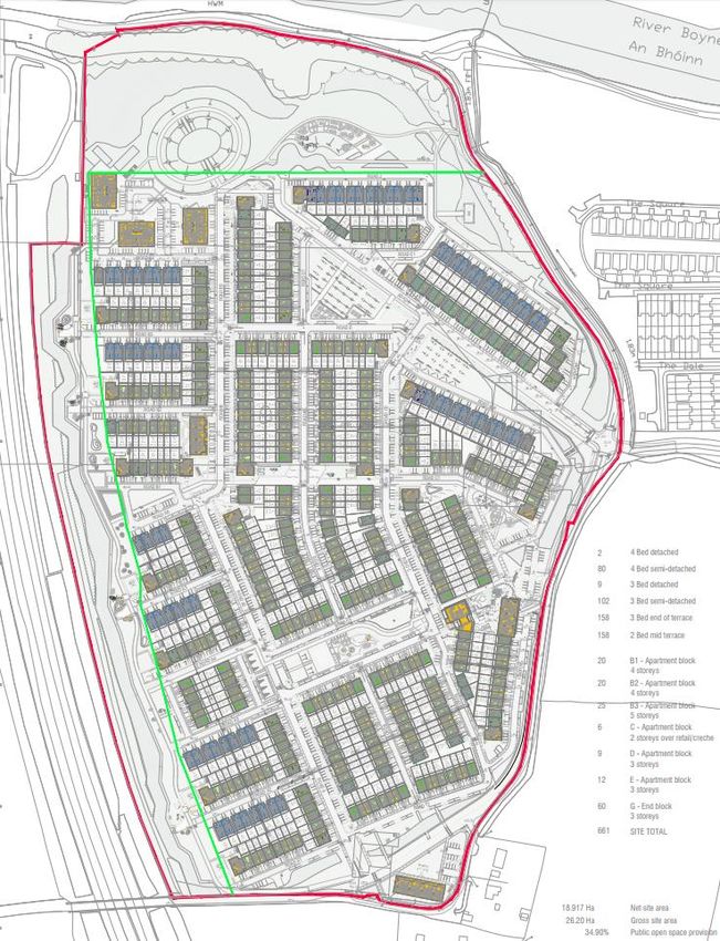
EIAR Non-Technical Summary                                                                    Trailford Ltd

1.0       Introduction

This Non-Technical Summary (NTS) of the Environmental Impact Assessment Report (EIAR) relates
to a Planning Application by Trailford Ltd. (referred to as the Applicant throughout) for proposed
residential development comprising the demolition of existing farm buildings and the construction of
509 no. dwellings; 152 no. apartments units, 1 no. retail unit, 1 no. café and a crèche on land at
Rathmullan Road, Rathmullan, Drogheda, Co. Meath.

Article 5(1)(e) of the EIA Directive requires that an Environmental Impact Assessment Report (EIAR)
is accompanied by a NTS of the EIAR and it is transposed into Irish law under article 94(c) of the
Planning and Development Regulations 2001, as amended.

This NTS presents a general overview of the proposed residential development and an assessment of
all associated potential environmental impacts. The term ‘non-technical’ indicates that this summary
should not include technical terms, detailed data and scientific discussion, that detail is presented in
Volume II of the EIAR.

2.0       Environmental Impact Assessment Requirements

The European Union (Planning and Development) (Environmental Impact Assessment) Regulations
2018, defines an EIAR as:

          ‘A report of the effects, if any, which proposed development, if carried out, would have on the
          environment and shall include the information specified in Annex IV of the Environmental
          Impact Assessment Directive.’

The subject development is not of a type or size that would require mandatory EIA under Annex I.
With respect to Annex II, the subject proposal would constitute an “infrastructure project” under Class
10. Given the no. of units proposed and the size of the subject site, EIA is required under Class
10(b)(i) and Class 10(b)(iv). Class 10(b)(i) relates to:

          “Construction of more than 500 dwelling units.”

Class 10(b)(iv) relates to:

          “Urban development which would involve an area greater than 2 hectares in the case of a
          business district, 10 hectares in the case of other parts of a built-up area and 20 hectares
          elsewhere.”

In order to ensure that all potential impacts associated with the development proposal are identified
and addressed, this EIAR provides a systematic and integrated evaluation of the direct, indirect and
secondary effects of the project on the natural and socio-economic environment.

The aim of the approach is to identify and predict (for a given proposed development) any impacts of
consequence; to describe the means and extent by which they can be avoided in the first instance or
reduced or ameliorated; to interpret and communicate information about the impacts; and to provide
an input into the decision making and planning process.

The aim of the EIAR is to:

      •   Describe the project using information on the site, design and size of the proposed
          development;
      •   Identify and predict any impacts on environmental features likely to be affected, having regard
          to the specific characteristics of the proposed development;
      •   Describe the measures envisaged in order to avoid, reduce and, where possible, remedy
          significant adverse effects;
      •   Provide the data required to identify and assess the main effects which the proposed
          development is likely to have on the environment; and
      •   Provide a Non-Technical Study of the information.

Residential Development at Rathmullan Road, Drogheda, Co. Meath                                      i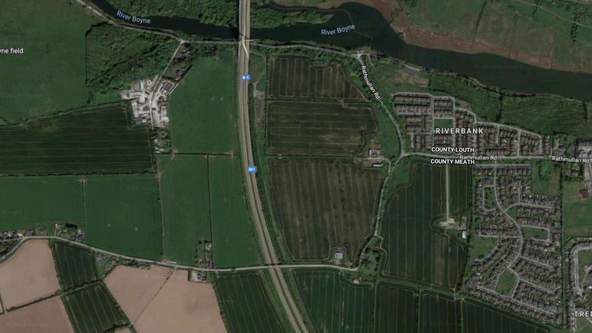
EIAR Non-Technical Summary                                                                    Trailford Ltd

2.1      EIAR Study Team

The EIAR was completed by a project team led by Hughes Planning and Development Consultants,
who also prepared a number of the chapters.

The members of the team and their respective inputs are outlined below in Table 1.0 below.

In accordance with EIA Directive 2014/52/EU, we confirm that experts involved in the preparation of
the EIAR are fully qualified and competent in their respective field. Each has extensive proven
expertise in the relevant field concerned, thus ensuring that the information provided herein is
complete and of high quality.

 Chapter No.       Chapter Title                                                 Contributor
                                                                            Hughes Planning and
 Chapter 1         Introduction                                            Development Consultants
                                                                                  (HPDC)
                   Proposed Development and Alternatives
 Chapter 2                                                                           HPDC
                   Considered Planning and Development Context
 Chapter 3         Planning and Development Context                                 HPDC
 Chapter 4         Population and Human Health                                      HPDC
 Chapter 5         Biodiversity                                                  Scott Cawley
 Chapter 6         Soils, Geology and Hydrogeology                             Waterman Moylan
 Chapter 7         Water                                                       Waterman Moylan
 Chapter 8         Noise and Vibration                                        AWN Consulting Ltd
 Chapter 9         Air Quality and Climate                                    AWN Consulting Ltd
                                                                           AWN Consulting Ltd and
 Chapter 10        Material Assets
                                                                               Waterman Moylan
                   Archaeology, Architectural and Cultural                 Archaeology and Heritage
 Chapter 11
                   Heritage                                                     Consultancy Ltd
 Chapter 12        Landscape and Visual Amenity                           Cunnane Stratton Reynolds
                                                                           HPDC in conjunction with
 Chapter 13        Interactions Between Environmental Factors
                                                                               above consultants
                                                                           HPDC in conjunction with
 Chapter 14        Principle Mitigation and Monitoring Measures
                                                                               above consultants

Table 1.0         EIAR Chapters and Contributors

3.0      Project Description

3.1      Site Location and Context

The subject site consists of a large parcel of land, c. 26.2 ha in size, located within the south western
environs of Drogheda, Co. Meath, c. 1.7km from the centre of the town, and is situated adjacent to the
Meath-Louth County Border. The site has road frontage along Rathmullan Road on the eastern
boundary of the site, with this road continuing along the southern boundary of the site. The site is
situated within a distance of between 25 and 70 metres of the M1 motorway on its western boundary,
and the northern extent of the site is situated within a distance of between 40 and 50 metres from the
southern bank of the River Boyne, with the site elevated c. 10 metres above the riverbank. The site
adjoins the buffer zone which protects the monuments of Newgrange, Knowth and Dowth.

The topography of the land is undulating. The site predominantly slopes gently towards the River
Boyne, with a steep embankment leading down towards the road which runs alongside the River
Boyne. Due to the fall of the land, the site is set above the adjoining M1 Motorway and smaller rural
road to the north adjoining the River Boyle.

The subject land is currently used as agricultural land. The site comprises 2 no. large fields and one
grazing field, with associated farm buildings used for cattle. There is significant planning along the
western boundary which provides an appropriate screen to the M1 Motorway.

Residential Development at Rathmullan Road, Drogheda, Co. Meath                                     ii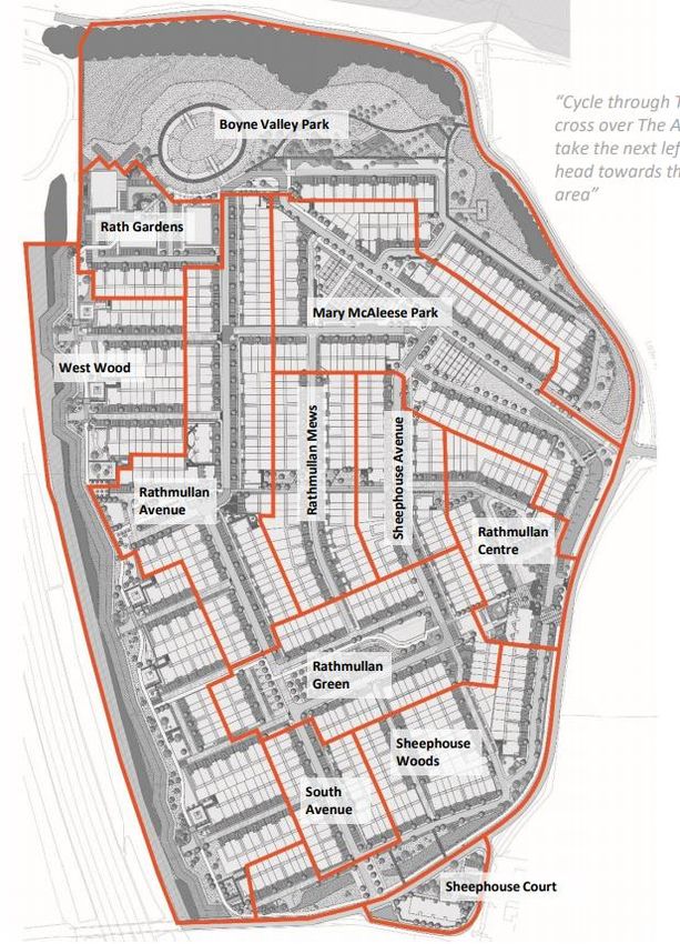
EIAR Non-Technical Summary                                                                      Trailford Ltd

Figure 2.1      Aerial view of subject site (red outline) in the context of the receiving environment

3.2      Proposed Development

The proposed development, as designed by NDBA Architects, involves the demolition of 2 no.
existing sets of farm buildings on the subject site and construction of a residential housing scheme
comprising 509 no. dwellings, 152 no. apartments/duplex units (providing a total of 661 no. residential
dwellings) and neighbourhood centre, comprising of a creche, a café and a retail unit, on the 26.2Ha
site.

More specifically, the proposal includes for the demolition of 2 no. sets of existing farm buildings on
the subject site. More specifically, a set of farm buildings adjacent to the site’s southern boundary and
a set of farm buildings adjacent to the site’s eastern boundary.

The development proposal will include the construction of 152 no. apartments (13 no. 1-bed
apartments and 139 no. 2 bed apartments) on the application site. Apartments will be provided within
26 no. purpose-built apartment blocks scattered throughout the development.

The development proposal will include the construction of 509 no. two storey family homes on the
application site. The scheme caters for growing families and those trading up from apartment living,
offering 158 no. 2-bedroom, 269 no. 3-bedroom and 82 no. 4-bedroom dwellings in various
configurations.

The proposed development features a neighbourhood centre, comprising a 486sq.m crèche, c.
63sq.m café and 318sq.m retail unit, adjacent to the site’s eastern boundary immediately south of the
northernmost entry to the proposed development. The building which houses the crèche and café is
double storey. The retail unit occupies the lower ground floor level of Apartment Block C, with this 3-
storey building sitting lower than the adjacent dwellings due to the topography of the site. The
proposed neighbourhood centre will be internally accessible from the development as well as via an
external road off Rathmullan Road.

The development will be served by 1,366 no. car parking spaces, 188 no. bicycle parking spaces and
9.15 hectares of public open space, including landscaped play spaces and pocket parks throughout
the development and 6.13 hectares of landscaped open space provided adjacent to the Boyne River
and M1 motorway frontages.

Residential Development at Rathmullan Road, Drogheda, Co. Meath                                         iii
EIAR Non-Technical Summary                                                                  Trailford Ltd

                                                                                   Site Access

Figure 2.2      Site layout plan of proposed development of 661 no. residential dwellings

The proposed development also includes the following:

  •   Construction of a 4-arm signalised junction and works to Rathmullan Road, including the
      widening of the existing carriageway to 6 metres and the provision of a 2 metre wide footpath
      linking the proposed development to the River Boyne Boardwalk;

Residential Development at Rathmullan Road, Drogheda, Co. Meath                                  iv
EIAR Non-Technical Summary Trailford Ltd
• Construction of 2 no. priority junctions (one along the site’s eastern boundary to provide access
to the neighbourhood centre and one along the site’s southern boundary to provide a second
access to the development), realignment and upgrade works to the un-named local road along
the site frontage to the south of the new signalised junction with Rathmullan Road; and
• Construction of a strategic foul water pumping station in the north-eastern corner of the site.
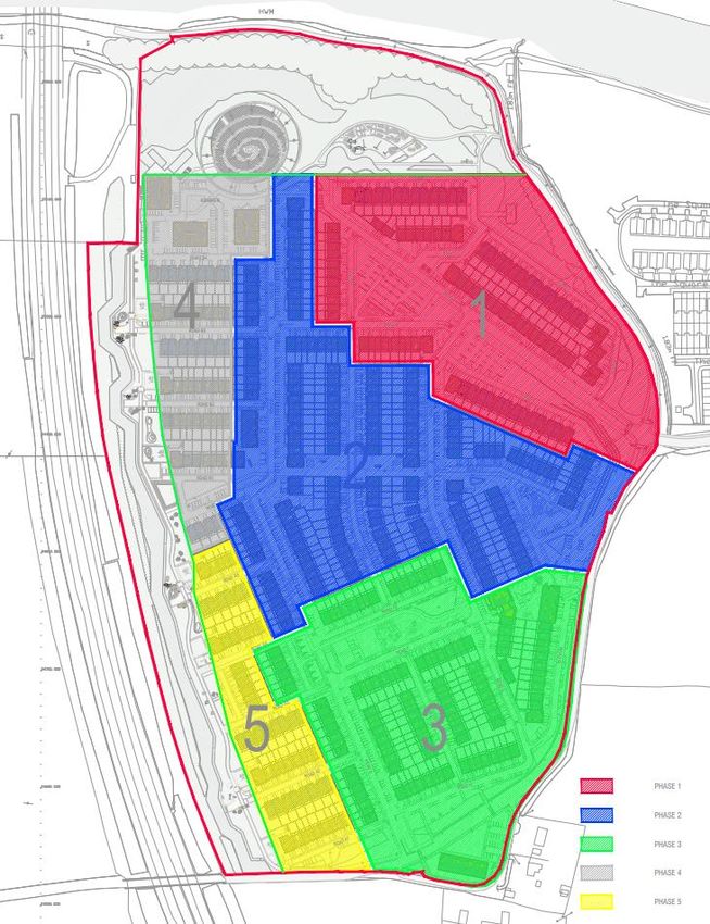
The proposed development will be constructed in 5 no. phases. The diagram included in Figure 2.3
below indicates the phasing of the proposed development. The proposed development will feature 12
no. neighbourhood areas, created through a combination of viewpoints, parks/open space areas,
architectural features and the hierarchy of streets, as illustrated in the plan excerpt included in Figure
2.3 below.
Figure 2.3 Proposed phasing of development (left) and proposed neighbourhood areas (right)
3.3 Alternatives Considered
The Planning and Development Regulations, 2001, as amended, require:
“A description of the reasonable alternatives studied by the person or persons who prepared
the EIAR, which are relevant to the proposed development and its specific characteristics,
and an indication of the main reasons for the option chosen, taking into account the effects of
the proposed development on the environment.”
Reasonable alternatives may include project design proposals, location, size and scale, which are
relevant to the proposed development and its specific characteristics.
Given the zoning of the subject site in the Meath County Development Plan 2013-2019, and having
regard to the project’s objectives, no reasonable alternative locations were considered.
The main alternatives studied during the development of this application comprises alternative design
and layout options for a largely residential development at the subject site (please see main report for
alternative design and layout options explored). The Architectural Design Statement, prepared by
NDBA Architects, Landscape Strategy & Design Report, prepared by Cunnane Stratton Reynolds,
Residential Development at Rathmullan Road, Drogheda, Co. Meath vEIAR Non-Technical Summary Trailford Ltd and Planning Report & Statement of Consistency, prepared by Hughes Planning and Development Consultants, which accompany the planning application also provide a detailed planning rationale for the development of the final layout. Alternative site layouts and siting progressed throughout the design process in order to minimise the impact on the receiving environment at the earliest opportunity. The initial stage involved a constraints analysis of the land within the proposed development site to identify all high-level constraints and aggregate them against the site to allow a suitable layout to be developed. These constraints included the sites topography, the M1 motorway to the west and the Boyne River to the north. As the design process progressed, the main alternatives studied in respect of the proposal were alternative design layouts (which generally achieved fewer unit numbers and a lower net residential density) and various options for the provision of pedestrian/cyclist connections to the existing boardwalk adjacent to the River Boyne, provision of open space and vehicular access to Rathmullen Road. These were not pursued for reasons relating biodiversity and traffic safety, among others. The scheme proposed in this application for permission has evolved from its original form and the consideration of alternative designs has resulted in significant environmental improvements in terms of the landscape and visual contribution that the proposed development will contribute to this area of Drogheda. 4.0 Human Beings, Population and Human Health The Population and Human Health chapter describes the significant effects of the development on the surrounding human environment in the general area of the subject site Rathmullan Road, Rathmullan, Drogheda, Co. Meath. The assessment of the effects of the proposed development will focus on: population levels; impact on employment and economic activity; land use and settlement patterns; housing; community infrastructure and social facilities; health and safety; and risk of major accidents and disasters. In considering the impacts of the proposed development on the above key items, the chapter will assess the impacts of the works both during the construction phase and operation phase. In order to assess the likely significant impacts of the proposed development on population and human health, an analysis of recent Census data was undertaken. Data relating to the St. Mary's (Part Rural) Electoral District (Electoral Division No. 11047), Co. Meath, the settlement of Drogheda and Small Area 167082008, were examined. The construction phase of the proposed development is likely to result in a positive net improvement in employment and economic activity particularly in the construction sector and in associated and secondary building services industries. The construction phase of the project may have some short-term negative impacts on local residents during the construction phase. Such impacts are likely to be associated with construction traffic, possible nuisances associated with construction activity and noise impact. However, such impacts will be short term and in the longer term, the completed scheme will have long-term beneficial impacts for local businesses, residents and the wider community. Further to this, the implementation of the range of remedial and mitigation measures included throughout this EIAR document are likely to have the impact of limiting any likely adverse environmental impacts of the construction and operational phase of the proposed development on population and human health. Once constructed, the proposed development will result in a generally positive alteration to the existing undeveloped green-field site in terms of the provision of residential units and significant areas of open space to serve the growing need for quality housing in the Drogheda area in accordance with local, regional and national planning policy guidance. The proposed development will bring about an increase in population in the wider area, which has experienced strong population growth during the 2011-2016 intercensal period. A diverse range of housing types are provided to satisfy different elements of housing demand and to ensure that the development is attractive to a varied cross section of the population. The proposed development will result in the addition of 661 no. units to the supply of housing in the Drogheda area. These will be a mixture of 1, 2, 3 and 4 bedroom residential units. In addition, the development also Residential Development at Rathmullan Road, Drogheda, Co. Meath vi
EIAR Non-Technical Summary                                                                    Trailford Ltd

complies with its Part V obligations and thus ensures a strong socioeconomic mix. The proposed
development also features a creche, café and retail units, located in the proposed neighbourhood
centre, which will serve the residents of the development and the wider area.

The proposal also includes large landscaped open spaces opposite the River Boyne and adjacent to
the site’s western boundary, as well as footpaths and cycle paths throughout the site which link to
adjacent road, pedestrian and cycle networks, which will significantly impact the social amenities of
the town in a positive manner. It will enable more residents and visitors to gain access to the River
and connect to existing green and social infrastructure in the town, improving residents’ ability to lead
a healthy lifestyle. This will be a significant positive impact of existing and future residents.

The population growth that will occur will contribute to the existing social and community
infrastructure. The new residents of the development would likely lead to increased funding and
patronage of existing services and facilities and the critical mass generated by the proposal would
likely create demand for new facilities and services, which would indirectly benefit the wider area.

Following consideration of the residual effects (post-mitigation), the proposed development will not
result in any significant effects on population and human health.

5.0      Biodiversity

This Biodiversity Chapter describes the likely significant effects on biodiversity resulting from the
proposed strategic housing development on lands at Rathmullan Road, Drogheda, Co. Meath. Where
necessary, mitigation measures are identified to address likely significant effects and the likely
residual effects are described.

The Biodiversity Chapter was authored by Laura Higgins (BA (Hons), checked and reviewed by Colm
Clarke (ACIEEM, MSc, BA (Hons)) and reviewed and approved by Aebhín Cawley (CEnv, MCIEEM,
PDip, BA (Hons)), Director Scott Cawley. All three are experienced ecologists with a range of
experiences in ecological survey and assessment.

The assessment takes account of international and national legislation relating to biodiversity, and
local authority policies relating to biodiversity. The assessment is based on the results of a desk study
and field surveys undertaken in 2018 and 2019. It has also been informed by prior field surveys
undertaken by Robertson and Associates in 2006 for previous applications at the same site. The
desk study included a search of datasets held by the National Parks and Wildlife Service (NPWS),
and National Biodiversity Data Centre (NBDC) as well as examination of information compiled for
previous planning applications within lands and adjacent lands. Field surveys were undertaken in
August and September 2018 and March 2019, and included habitat and invasive species surveys,
and surveys for rare and protected fauna species and birds. Consultations were made to the NPWS,
with a response received on 22nd November 2018.

The lands are not within any designated sites, but are directly adjacent to the River Boyne and River
Blackwater Special Area of Conservation (SAC) (002299), which is designated for a range of
terrestrial and aquatic habitats and species, and are within 100m of the River Boyne and River
Blackwater Special Protection Area (SPA) (004232), which has been designated for its population of
the wetland bird species Kingfisher Alcedo atthis. The subject lands are hydrologically connected to
these European sites via the surface water network. They are also connected to additional
downstream European sites within the Boyne Estuary, which have been designated for their coastal
and marine habitats and wetland bird species. With regards to nationally protected sites, the Boyne
River Islands pNHA is within 200m of the lands and has been designated for its example of alluvial
woodland habitat. Information for the completion of appropriate assessment screening has been
prepared. It has concluded that the possibility of significant effects on European sites from the
proposed development, either alone or in-combination with other plans and projects, cannot be
excluded. For this reason, a Natura Impact Statement has been prepared for the proposed
development.

No notable or protected flora species occur within the subject lands. Several habitats of ecological
value were identified within and adjacent to the subject lands, including an area of oak-ash-hazel
woodland. The area of oak-ash-hazel woodland on the northern site boundary is considered to be of

Residential Development at Rathmullan Road, Drogheda, Co. Meath                                    vii
EIAR Non-Technical Summary                                                                      Trailford Ltd

county importance, due to its naturalness, its location in the River Boyne Valley, and its relative
scarcity at a county level. Other habitats within the proposed development site considered to be key
ecological receptors (KERs), and of local importance are hedgerows, treelines and dry meadows and
grassy verges.

In terms of protected fauna, the lands are considered to be suitable for a range of bat species, and
they contain two locally important small roosts of soprano pipistrelle bat Pipistrellus pygmaeus within
farm buildings in the south and east of the lands. No signs of badger Meles meles or otter Lutra lutra
were found during surveys of the lands. Several mammal paths were noted within the lands, and
based on desk records and site surveys, are likely to be utilised by a range of mammals such as deer,
Irish hare Lepus timidus hibernicus, fox Vulpes vulpes and hedgehog Erinaceus europaeus.

Significant effects are predicted to arise at the construction phase of the proposed development from:
the demolition of buildings within the lands; the removal of hedgerows; and, the potential generation
and mobilisation of silts, sediments and other pollutants to the local surface water network.
Disturbance impacts have been considered during construction but are not predicted to be significant.
Operational phase impacts are predicted from the operation of artificial lighting to previously unlit
habitat and disturbance from increased human traffic within the lands.

In the absence of mitigation, the possibility of significant effects cannot be ruled out with regards to
European sites. Potential impacts on European sites are considered to arise from the mobilisation of
silt and/or pollutants to the River Boyne during construction and operation of the proposed
development. Silt and pollution control measures have been proposed for the lands during
construction, which will be overseen by a suitably qualified person. Design measures have been
provided for the retention and treatment of operational surface waters prior to their release to the local
surface water network. Following the implementation of the aforementioned design and mitigation
measures, there will be no significant effects on designated sites. The conclusion for the Natura
Impact Statement states that it is the professional opinion of the authors of the report that there will be
no adverse effects on the integrity of any European sites.

With regards to habitats, significant impacts are predicted during the construction phase of the
proposed development in the absence of mitigation. This would arise from the loss of hedgerow and
dry meadows habitats during site clearance works; potential accidental damage to retained woodland
and hedgerow habitats through machinery strikes or compaction of soils during construction works;
and accidental pollution of watercourses downstream of the lands. Measures have been provided for
the protection of retained habitats, including the use of setback distances, protective fencing, and the
utilisation of a root protection zone. Compensatory measures have been proposed for the loss of
hedgerow and dry meadow habitats, including additional woodland planting, tree planting, and
establishment of wildflower areas. Residual impacts have been reduced to levels not deemed
significant with regards to retained habitats and dry meadows. Residual impacts remain significant at
a local level for hedgerows as there will be the unavoidable net loss of hedgerows, which will reduce
the level of habitat connectivity within the lands.

With regards to fauna, significant effects are predicted to arise from loss of suitable habitat of bats
and birds, and from mortality of bats and birds arising from the destruction of bat roosts and/or bird
nests, respectively, during the construction phase of the proposed development. Operational phase
impacts extend to the introduction of artificial lighting to the lands, and the illumination of suitable
habitat for roosting bats, which could result in abandonment of this habitat by bats, and loss of
connectivity across the lands. Measures have been proposed to address these impacts. In the case of
bats, a mitigation strategy and draft application for derogation licence has been forwarded to the
NPWS for the removal of roosts from the lands, and compensatory replacement with alternative
roosts in the north of the lands. Measures have been proposed for the minimisation of lighting along
potential commuting and foraging routes for bats during operation of the proposed development. In
the case of birds, measures have been proposed to prevent mortality of birds during construction.
Residual impacts have been reduced to levels not considered to be significant in the case of birds.
Significant impacts remain in the case of bats, albeit at a local scale, arising from the unavoidable loss
of hedgerow habitat within the lands.

Cumulative effects have been considered, with no additional significant residual effects predicted
following implementation of mitigation measures.

Residential Development at Rathmullan Road, Drogheda, Co. Meath                                     viii
EIAR Non-Technical Summary                                                                        Trailford Ltd

Monitoring has been proposed to ensure success of mitigation.

6.0      Soils Geology and Hydrogeology

The ground conditions encountered reflect a typical description of the boulder clays deposited during
the last glacier movement in the region and are common along the mid-eastern area of Ireland.
Locally, peats reflect decay of organic materials over a significant period of time, while some fluvial
glacial materials may also be encountered as a result of the water flowing from melting glaciers.

The proposed development spans an area predominately underlain by one geological formation – the
Platin Formation being Crinoidal peloidal grainstone-packstone.

The proposed development is located approximately 9.6 km west of the Irish Sea, with the River
Boyne located adjacent the northern boundary of the site. It is proposed that surface water drainage
from the proposed development will discharge to the existing 1200 mm culvert adjacent Rathmullan
Road at the north-east of the site before. This culvert flows into a ditch which then outfalls to the
River Boyne.

The site is located above a regionally important aquifer, described as a karstified diffuse aquifer.

The removal of topsoil and the earthworks will expose subsoil to weathering and may result in some
minor erosion of the soils during the short construction period, in particular following extreme dry and
sunny or prolonged wet weather conditions. The lack of topsoil is likely to give rise to dust from the
subsurface during dry periods.

Measures will be implemented throughout the construction stage to prevent contamination of the soil
and adjacent watercourses from oil and petrol leakages and significant siltation. Suitable bunded
areas will be installed for oil and petrol storage tanks. Designated fuel filling points will be put in place
with appropriate oil and petrol interceptors to provide protection from accidental spills. Spill kits will be
provided by the Contractor to cater for any other spills.

Cut-off trenches connected to settlement ponds / silt traps will be constructed adjacent the
development area to intercept silt arising from surface water runoff across the exposed sub-soil.
Dampening down measures with water sprays will be implemented during periods of dry weather to
reduce dust levels arising from the development works.

After implementation of the above measures the proposed development will not give rise to any
significant long-term adverse impact. Negative impacts during the construction phase will be short
term only in duration.

Due to the implementation of the remedial or reductive measures outlined above, the proposed
development will not give rise to any significant long-term adverse impact. Negative impacts during
the construction phase will be short term only in duration.

7.0      Water

The development lands are located within the catchments of the River Boyne. The area is currently
drained by a series of drainage ditches that discharge into the River Boyne to the north.

The proposed development will generate additional surface water runoff from development of the
future roads and buildings. Surface water runoff from the roads, parking and service yards will
generally contain an element of hydrocarbons and worn tyre rubber as well as other detritus material.

The key governing factor in designing a suitable surface water drainage network is the requirement to
limit the rate of discharge to the equivalent Greenfield runoff rate and to improve the quality of the
runoff. In this particular case, the development drainage will discharge into a ditch / culvert that flows
into the River Boyne. In order to limit the discharge rate from the development, a sustainable urban
drainage system will be design, which will include attenuation areas, where the flow of the water will
be restricted to that of Greenfield runoff.

Residential Development at Rathmullan Road, Drogheda, Co. Meath                                        ix
EIAR Non-Technical Summary                                                                      Trailford Ltd

A new foul water pumping station will be provided on the subject site to serve the proposed
development. The ‘Riverbank’ housing estate, adjacent to the subject site, is currently served by an
existing pumping station. Furthermore, a new residential development has been granted planning
under Reg. Ref. LB170675 which requires the construction of a foul water pumping station to serve
that development. It is proposed that the new pumping station on the subject site will be a strategic
pumping station which will take the waste water from ‘Riverbank’ housing estate and from this
proposed new residential development. This will eliminate the need for separate individual pumping
stations. Foul water will be pumped from the new pumping station via a 110 mm rising main and
connect to the existing 110 mm diameter rising main on Rathmullan Road to the east of the subject
site. Ultimately this foul water discharges to into the existing gravity sewer network on Marley’s Lane
c 900 m east of the subject site. Foul drainage eventually outfalls to the Drogheda Wastewater
Treatment Plant. The existing sewer network has capacity to cater for the development of the subject
lands.

Water will be supplied via a connection to the existing water main on the Rathmullan Road to the east
of the subject site.

Surface Water

Potential Impact of the Proposal - Construction Phase

The following potential impacts from the construction of the proposed development may occur:

  •    There is a risk that once topsoil has been stripped from the site there will be higher runoff rates
       from the lands with increased amount of silt to existing watercourses in the runoff.
  •    There is a risk of pollution of groundwater / watercourses / soils by accidental spillage of oils /
       diesel from temporary storage areas or where maintaining construction equipment.
  •    There is a risk of damage to existing buried utilities during excavations works resulting in
       temporary loss of supply to existing properties
  •    There is a possibility of a temporary Increase in traffic due to deliveries of materials and other
       construction related traffic.
  •    There will be some minor disruption to traffic when constructing the outfall pipe across
       Rathmullan / River Road.
  •    Cross connection between surface water and foul pipes.

Potential Impact of the Proposal - Operational Phase

The following potential impacts from the construction of the proposed development may occur:

  •    There is a potential impact from increased surface water flows that could lead to downstream
       flooding.
  •    There is a potential impact for the discharge of contaminants from the proposed development
       and road surfaces to the surrounding drainage ditches, which ultimately drain to the River
       Boyne. These would include particulates, oil, soluble extracts from the bitumen binder etc. The
       quality of runoff from the site would be dependent on the time of year, weather, particulate
       deposition from the atmosphere and any gritting or salting carried out by the Local Authority.
       The time of year has a major bearing on the quality of storm water run-off - in particular the first
       rains after a prolonged dry period where accumulated deposits of rubber, particulates, oils, etc.
       are, washed away.
  •    Stagnation of the water and siltation within the attenuation areas may occur.

Potential Impact of the Proposal - ‘Do Nothing’ Scenario

Surface water runoff would continue to be discharged to the receiving ditches / culvert at existing
discharge rates.

Ameliorative, Remedial or Reductive Measures - Construction Phase

  •    The contractor will appoint a suitably qualified person to oversee the implementation of
       measures for the prevention of pollution to the receiving surface water environment.

Residential Development at Rathmullan Road, Drogheda, Co. Meath                                       x
EIAR Non-Technical Summary Trailford Ltd
• Cut off trenches along the northern boundary of the development boundary will be constructed
prior to stripping topsoil. These cut off trenches will have a settlement pond / silt trap at the end
of each trench with an overflow. Straw bales will be placed within the cut off trenches at
strategic locations and at the outfall of the settlement ponds to the overflow. These measures
will be implemented and maintained during the construction phase to prevent surface water
runoff from discharging directly into the local water course. An indicative layout for the
proposed cut off trenches is set out in Appendix A of this EIAR.
• Settlement ponds / silt traps as outlined above will be provided to prevent silt runoff into the
existing ditches / watercourses during the drainage works
• Regular testing of surface water discharges will be undertaken at the outfall from the subject
lands. The location will be agreed between the project ecologist and the site foreman at the
commencement of works. Trigger levels for halting works and re-examining protection
measures will be: pH >9.0 or pH 25 mg/l. These trigger levels
are based on those outlined within ‘Guidelines on Protection of Fisheries During Works in and
Adjacent to Waters (IFI, 2016)’.
• Where silt control measures are noted to be failing or not working adequately, works will cease
in the relevant area. The project ecologist will review and agree alternative pollution control
measures, such as deepening or redirecting trenches as appropriate, before works may
recommence.
• All fuels and chemicals will be bunded, and where applicable, stored within double skinned
tanks / containers with the capacity to hold 110% of the volume of chemicals and fuels
contents. Bunds will be located on flat ground a minimum distance of 50 m from any
watercourse or other water conducting features, including the cut off trenches.
• All existing services will be located using service records, GPR surveys and slit trenches to
ensure that their position accurately identified before excavation works commence.
• Temporary traffic management will be implemented as appropriate during the construction of
the outfalls on Rathmullan / River Road.
Ameliorative, Remedial or Reductive Measures - Operational Phase
• Flow restrictors with attenuation storage will be used to slowdown and store surface water
runoff from discharging above green field rates to the ditch / culvert.
• Attenuation systems will be constructed on-line to intercept the first flush during rainfall events
after periods of dry weather. Furthermore, the proposed Stormtech attenuation system
contains an ‘Isolator Row’ which provides treatment even in low flow conditions. This row is
surrounded with filter fabric that provides for settling and filtration of sediments as the water
passes through. This ensures that the majority of the solids are removed within the isolator row
which prevents silt build-up in the remainder of the chambers, therefore minimising
maintenance requirements and associated costs. The Stormtech systems have a stone base
and permeable chambers which encourages water to permeate into the ground.
• Sustainable urban drainage measures such as filter drains, permeable paving, rain water
harvesting, swales etc. will be provided.
• A petrol interceptor will be installed to prevent hydro carbons entering the local ditch / culvert.
• The attenuation storage systems will be constructed at a fall to maintain movement of water
and thus prevent stagnation. Silt would be collected at a sump and removed periodically.
• Regular maintenance of the drainage network, including petrol interceptor.
Predicted Impact of the Proposal - Construction Phase
Due to the proposed ameliorative remedial and reductive measures outlined above many of the
potential impacts will not arise during the construction phase of the proposed development on surface
water quality.
There will be increases in traffic flows at the local road network due to deliveries of materials and
some minor disruption to traffic during the construction of the outfalls on Rathmullan Road / River
Road.
Residential Development at Rathmullan Road, Drogheda, Co. Meath xiEIAR Non-Technical Summary Trailford Ltd
Predicted Impact of the Proposal - Operational Phase
Due to the proposed ameliorative remedial and reductive measures outlined above many of the
potential impacts will not arise during the operation phase of the proposed development on surface
water quality.
Surface water discharge from the site will be restricted by means of attenuation, therefore, no adverse
impact in respect of flooding downstream will arise from the proposed development.
The attenuation system will be position on-line to provide treatment to the ‘first flush’ and will be
constructed with permeable chambers to encourage infiltration. The installation of a petrol interceptor
upstream of the outfall will ensure that any remaining hydro-carbons or pollutants within the runoff
from trafficked areas are treated.
The installation of trapped gullies in accordance with BS 5911 will minimise the risk of contamination
of the surface water system by floating debris.
The installation of a Sustainable Urban Drainage System will improve water quality to the surface
water discharged to the local watercourses and the River Boyne.
Predicted Impact of the Proposal - ‘Worst Case’ Scenario
A worst-case scenario is that for a very intense storm, minor ponding may occur within the site.
Water Supply
Potential Impact of the Proposal - Construction Phase
• There is a risk of contamination of the existing water supply during construction of the
development when connection of the trunk watermain to the public water supply is being made.
• There is a risk of damage to watermain fittings due to high pressure in the existing watermain.
• There will be a minor water demand for site offices.
• There will be increases in traffic flows at the local road network due to deliveries of materials.
• There is a risk of damage to existing buried utilities during excavations works resulting in
temporary loss of supply to existing properties
• The proposed development will not give rise to any significant long term adverse impact.
Negative impacts during the construction phase will be short term only.
Potential Impact of the Proposal - Operational Phase
During the operational phase, the total water requirement, from the public supply, for the development
is estimated at 271,160 m3/day
Potential Impact of the Proposal - ‘Do Nothing’ Scenario
In this scenario, the existing water demand would continue on the Irish Water network in Drogheda.
There would be no additional demand.
Ameliorative, Remedial or Reductive Measures - Construction Phase
• All existing services will be located using service records, GPR surveys and slit trenches to
ensure that their position accurately identified before excavation works commence.
• A pressure reducing valve will be installed at the connection point.
• All water mains will be cleaned, sterilised and tested to the satisfaction of the Irish Water/Local
Authority prior to connection to the public water main.
• All connections to the public water main will be carried out under the supervision of the Irish
Water/Local Authority.
Residential Development at Rathmullan Road, Drogheda, Co. Meath xiiEIAR Non-Technical Summary Trailford Ltd
Ameliorative, Remedial or Reductive Measures - Operational Phase
It is not envisaged that any other remedial or reductive measures will be necessary upon the
completion of the development.
Predicted Impact of the Proposal - Construction Phase
Due to the proposed ameliorative remedial and reductive measures outlined above no significant
impact will arise during the construction phase of the proposed development on water quality.
There will be an increase in traffic flows at the local road network due to deliveries of materials.
There will be disruption to local traffic during the connection of the watermains from the proposed
development to the existing watermains on Rathmullan Road.
Predicted Impact of the Proposal - Operational Phase
There will be an increased demand for water supply due to the development.
Potential Impact of the Proposal - ‘Worst Case’ Scenario
A worst case scenario would be that water mains would be contaminated during the construction
phase. This would be mitigated against by scouring out the mains, swabbing and chlorinating the
mains prior to occupation of any of the units.
Foul Water
Potential Impact of the Proposal - Construction Phase
The following potential impacts from the construction of the proposed development may occur:
• There is a risk of the ingress of ground/surface water to the foul water network.
• There is a risk of damage to existing buried utilities during excavations works resulting in
temporary loss of supply to existing properties.
• There is a possibility of a temporary Increase in traffic due to deliveries of materials and other
construction related traffic.
• There will be some disruption to traffic during construction works on the public road.
• Cross connection between foul and surface water pipes.
Potential Impact of the Proposal - Operational Phase
• Blockages may occur within the pipe network and the waste water could become septic.
• Foul water could be connected to the surface water drainage network.
• The pumps could fail and wastewater could overflow across the open space and ultimately to
the River Boyne.
Potential Impact of the Proposal - ‘Do Nothing’ Scenario
In this scenario, the existing foul water demand would continue on the Irish Water network in
Drogheda. There would be no additional demand.
Ameliorative, Remedial or Reductive Measures - Construction Phase
• All existing services will be located using service records, GPR surveys and slit trenches to
ensure that their position accurately identified before excavation works commence.
• Foul water pipes to be laid with sufficient falls to ensure self-cleansing velocity
• Foul and surface water pipes will be carefully laid so as to minimise the potential for cross
connections.
Residential Development at Rathmullan Road, Drogheda, Co. Meath xiiiEIAR Non-Technical Summary Trailford Ltd
Ameliorative, Remedial or Reductive Measures - Operational Phase
The pumping station is being provided with the following emergency equipment and procedures: -
• Standby pump in the event of a pump failure;
• Telemetry system to facilitate Irish Water monitoring of the station;
• High level alarms to warn of increases in level of effluent in the pump sump;
• Storage capacity within the sump and pipe network in excess of 24 hours; and
• Over-pumping facilities on the rising main to facilitate the installation of a temporary external
pump to empty the sump directly into the rising main.
The above emergency equipment and procedures provide a very high level of redundancy and
backup in the event of a failure in the mechanical systems in the pumping station.
In addition to the above, the drainage network will be inspected annually and maintained.
Predicted Impact of the Proposal - Construction Phase
Due to the proposed ameliorative remedial and reductive measures outlined above no significant
impact will arise during the construction phase of the proposed development on foul water network.
There will be increases in traffic flows at the local road network due to deliveries of materials.
There may be short term disruption to local traffic on connection of the foul sewers from the proposed
development to the existing foul sewers.
Predicted Impact of the Proposal - Operational Phase
There will be increased flows in the existing foul water drainage network.
‘Worst Case’ Scenario
A worst case scenario would be that foul water would be discharged to the surface water network.
This would be mitigated against by ensuring no crossing connections during the construction stage.
Poor workmanship could result in large quantities of surface water entering the existing foul drainage
network and overloading the network.
8.0 Noise and Vibration
AWN Consulting Ltd. have carried out an assessment of the potential noise and vibration impacts
associated with the proposed residential development at Rathmullan Road, Drogheda. Co. Meath.
The assessment identifies potential noise and vibration impacts on the environment, during both the
short-term construction and longer-term operational phases. The assessment was conducted in the
context of current relevant standards and guidance and used to specify appropriate limit values and
mitigation measures to ensure that the impact is minimised.
The existing noise climate in the vicinity of the proposed development has been surveyed across the
site over the course of a typical weekday period. The key noise sources are road traffic noise from the
M1 and other local roads.
During the construction phase of the project there is the potential for temporary noise impacts on
nearby noise sensitive properties due to noise emissions from site activities. The application of
binding noise limits and hours of operation, along with implementation of appropriate noise and
vibration control measures, will ensure that noise and vibration impact is kept to a minimum as far as
practicable. For the duration of the construction period, construction noise impacts will be short-term,
negative, slight to moderate. Vibration impacts during the construction phase will be short-term and
negligible.
The predicted change noise levels associated with additional traffic is predicted to be of imperceptible
impact along the existing road network. In the context of the existing noise environment, the overall
Residential Development at Rathmullan Road, Drogheda, Co. Meath xivEIAR Non-Technical Summary Trailford Ltd contribution of induced traffic is considered to be of neutral, imperceptible and long-term impact to nearby residential locations. Noise levels associated with building services plant are expected to be well within the adopted day and night-time noise limits at the nearest noise sensitive properties taking into account the site layout, the nature and type of units proposed and distances to nearest residences. Assuming the operational noise levels do not exceed the adopted design goals, the resultant residual noise impact from this source will be of neutral, imperceptible, long term impact No significant sources of vibration are expected to arise during the operational phase of the development. The potential for inward noise impact on the proposed development has been assessed. The assessment has been carried out with reference to the guidance contained in professional Guidance on Planning & Noise (ProPG), BS 8233:2014 Guidance on Sound Insulation and Noise Reduction for Buildings (BSI); and the local and national Noise Action Plans relevant to the area. To ensure appropriate external noise levels are achieved across the site a 4m high earth berm is proposed along the western boundary to provide screening to the M1. In addition, to achieve suitable internal noise levels within buildings located closest to the boundary with the M1 minimum sound insulation specifications have been provided for windows and vents. By their nature noise and vibration impacts are localised to the area immediately adjacent to the development site. Therefore, the potential for cumulative impacts are low. The exception to this is the additional noise generated by increased traffic volumes on the surrounding road network, where the increased traffic flow can occur at locations remote from the development. However, in the context of noise, the potential for impact is low, given that very large increases in traffic volume are required to generate a noticeable noise impact. In summary, the potential for cumulative noise and vibration impacts is low but will be assessed as part of the overall impact assessment. 9.0 Air Quality and Climate AWN Consulting Limited has been commissioned to conduct an assessment of the likely impact on air quality and climate associated with the proposed the residential development at Rathmullen, Drogheda, Co. Meath. In terms of the existing air quality environment, baseline data and data available from similar environments indicates that levels of nitrogen dioxide, carbon monoxide, particulate matter less than 10 microns and less than 2.5 microns and benzene are generally well below the National and European Union (EU) ambient air quality standards. Impacts to air quality and climate can occur during both the construction and operational phases of the proposed development. With regard to the construction stage the greatest potential for air quality impacts is from fugitive dust emissions impacting nearby sensitive receptors. Impacts to climate can occur as a result of vehicle and machinery emissions. In terms of the operational stage air quality and climate impacts will predominantly occur as a result of the change in traffic flows or congestion in the local areas associated with the proposed development. Any potential dust impacts can be mitigated through the use of best practice and minimisation measures which are outlined in this report. Therefore, dust impacts will be short-term and imperceptible at all nearby sensitive receptors. It is not predicted that significant impacts to climate will occur during the construction stage due to the relatively small scale of the development and the low volume of vehicles and machinery predicted. The local air quality modelling assessment concluded that levels of traffic-derived air pollutants resulting from the development will not exceed the ambient air quality standards either with or without the proposed development in place. Using the assessment criteria outlined in Transport Infrastructure Ireland’s guidance document ‘Guidelines for the Treatment of Air Quality During the Planning and Construction of National Road Schemes’ the impact of the development in terms of PM10, PM2.5, CO, NO2 and benzene is long-term and imperceptible. The proposed development is not predicted to significantly impact climate during the operational stage. Increases in traffic derived levels of NO X, VOCs and CO2 have been assessed against Ireland’s obligations under the EU Targets and emissions ceilings set out by Directive (EU) 2016/2284 “On the Reduction of National Emissions of Residential Development at Rathmullan Road, Drogheda, Co. Meath xv
EIAR Non-Technical Summary                                                                      Trailford Ltd

Certain Atmospheric Pollutants and Amending Directive 2003/35/EC and Repealing Directive
2001/81/EC”. Impacts to climate are deemed imperceptible and long-term with regard to NOX, VOCs
and CO2 emissions.

It is predicted that the impact of the operational phase traffic will lead to an imperceptible increase in
nitrogen oxide concentrations within a section of the Boyne River Islands pNHA, River Boyne and
River Blackwater SPA and River Boyne and River Blackwater SAC.

As the National and EU standards for air quality are based on the protection of human health, and
concentrations of pollutants for both the construction and operational stages of the proposed
development are predicted to be significantly below these standards, the impact to human health is
predicted to be imperceptible and not significant in the short and long term.

No significant impacts to either air quality or climate are predicted during the construction or
operational phases of the proposed development.

10.0     Material Assets

10.1     Waste Management

AWN Consulting Ltd. carried out an assessment of the potential impacts associated with waste
management during the construction and operational phases of the proposed development. The
receiving environment is largely defined by Meath County Council as the local authority responsible
for setting and administering waste management activities in the area through regional and
development zone specific policies and regulations.

During the demolition and construction phases, typical C&D waste materials will be generated which
will be source segregated on-site into appropriate skips/containers, where practical and removed from
site by suitably permitted waste contractors to authorised waste facilities. Where possible, materials
will be reused on-site to minimise raw material consumption. Source segregation of waste materials
will improve the re-use opportunities of recyclable materials off-site. Site levelling, construction of new
foundations, the installation of underground services and attenuation tanks will require the excavation
of topsoil and subsoil. It is anticipated that all excavated material will be able to be reused onsite. If
material is required to be removed offsite it will be taken for offsite reuse, recovery, recycling and/or
disposal.

A carefully planned approach to waste management and adherence to the site-specific Construction
and Demolition Waste Management Plan (Appendix 10.1) during the construction phase will ensure
that the effect on the environment will be short-term, neutral and imperceptible.

During the operation phase, waste will be generated from the residents as well as the retail, café and
crèche tenants. Dedicated communal waste storage areas have been allocated for the residents of
apartments blocks in close proximity of their residence, while residents in houses and duplexes will
have their own individual waste storage areas. All waste storage areas have been appropriately sized
to accommodate the estimated waste arisings. The retail, café and crèche tenants will have a
dedicated waste storage area at the rear of clock C. The waste storage areas have been allocated to
ensure a convenient and efficient management strategy with source segregation a priority. Waste will
be collected from the waste storage areas by permitted waste contractors and removed off-site for re-
use, recycling, recovery and/or disposal.

An Operational Waste Management Plan has been prepared which provides a strategy for
segregation (at source), storage and collection of wastes generated within the development during the
operational phase including dry mixed recyclables, organic waste, mixed non-recyclable waste and
glass as well as providing a strategy for management of waste batteries, WEEE, printer/toner
cartridges, chemicals, textiles, waste cooking oil and furniture (Appendix 1o.2). The Plan complies
with all legal requirements, waste policies and best practice guidelines and demonstrates that the
required storage areas have been incorporated into the design of the development.

Residential Development at Rathmullan Road, Drogheda, Co. Meath                                     xvi
EIAR Non-Technical Summary                                                                     Trailford Ltd

Provided the mitigation measures outlined in Chapter 10 are implemented and a high rate of reuse,
recycling and recovery is achieved, the predicted effect of the operational phase on the environment
will be long-term, neutral and imperceptible.

10.2     Traffic and Transport

Introduction

The site is located on Rathmullan Road in Drogheda, Co. Meath. The site is situated approximately
2.5 km west of Drogheda town centre and is bounded to the north by the River Boyne, to the east by
existing residential and agricultural areas, to the south by agricultural lands, and to the west by the M1
Dublin to Belfast Motorway.

Proposed Road Network

Access to the subject site will be provided on Rathmullan Road to the east of the subject site by
means of a proposed 4 arm signalised junction, and an alternative access on the local access road to
the south of the site by means of a proposed priority junction. Internal estate roads are generally 6 m
wide with corner radii ranging from 3 to 6 m. Various speed reduction measures have been
implemented within the roads layout such as raised crossings, shared surface / home zone areas and
on-street parking. Car parking spaces have generally been provided in accordance with the Meath
County Council standards.

Footpaths will be provided in accordance with Section 4.3.1 of DMURS which suggests that a
minimum 1.8m footpath should be provided on all footways. Crossing points are located at various
points within the development such that unimpeded pedestrian movement is facilitated. Cyclists will
be kept on-road within the proposed development. Accordingly, the proposed development is
consistent with the principles outlined in DMURS.

Further to discussions with Meath County Council, it is also proposed to upgrade a section of the
existing Rathmullan Road along the eastern boundary of the subject site by widening the carriageway
to 6m and providing a new kerb with gullies for surface water drainage. Pedestrian access links from
the proposed development and the existing footpath on Rathmullan Road will also be provided via a
new 2m wide footpath which facilitates access to the River Boyne walkway.

It is also proposed to implement minor upgrades to Rathmullan Road along the northern boundary of
the site. This includes the widening of the existing carriageway to 6 m. This section of road down to
Oldbridge House currently operates with a stop / yield one-way system in place as the River Boyne
greenway is intermittently on-road in this area. Furthermore, this road is not intended to operate as a
major link and therefore anticipated traffic volumes will be low.

Sustainable Access

A pedestrian link will be provided between the proposed development and the existing walkway along
the River Boyne by the inclusion of a new footpath along Rathmullan Road to the north-east. There is
an existing continuous footpath along the north side of Rathmullan Road. The proposed development
provides a connection to these facilities and hence, provides access to Drogheda Town Centre and
local schools and community centres on Rathmullan Road.

The site is within walking / cycling distance of high quality public transport services such as the
Drogheda Bus Station and Drogheda Train Station. The Drogheda Bus Station is located 2.5 km to
the east of the subject site, which provides a high number of local and national bus routes. The
Drogheda Rail Station is located 3.5 km to the east of the subject site, which is located on the
Northern Commuter line running between Newry and Dublin Pearse Street. This line extends north to
Belfast Central and south to Rosslare Europort.

Traffic Impact

In order to quantify the volumes of traffic movements at key points on the road network adjacent to
the site, a set of classified turning movement traffic counts were commissioned. Accordingly, a

Residential Development at Rathmullan Road, Drogheda, Co. Meath                                    xvii
You can also read