DIGIPLAN - Digital plans and plan data in Switzerland - TARGETED ANALYSIS
←
→
Page content transcription
If your browser does not render page correctly, please read the page content below
TARGETED ANALYSIS //
DIGIPLAN – Digital plans and plan
data in Switzerland
Annex 8 of final report
Final report // June 2021
This Targeted analysis was conducted within the framework of the ESPON 2020 Cooperation
Programme, partly financed by the European Regional Development Fund.

The ESPON EGTC is the Single Beneficiary of the ESPON 2020 Cooperation Programme. The
Single Operation within the programme is implemented by the ESPON EGTC and co-financed by
the European Regional Development Fund, the EU Member States, the United Kingdom and the
Partner States, Iceland, Liechtenstein, Norway and Switzerland.

This deliverable does not necessarily reflect the opinions of members of the ESPON 2020
Monitoring Committee.

Coordination and Outreach
Christian Fertner, University of Copenhagen and Piera Petruzzi, ESPON EGTC

Authors
Swiss Federal Research Institute WSL (Switzerland): Anna Hersperger, Silvia Tobias, Corina
Wittenwiler

Cite as
ESPON DIGIPLAN (2021) DIGIPLAN – Digital plans and plan data in Switzerland. Annex 8 of
final report. https://www.espon.eu/digiplan

Advisory group
Stakeholders: Ole Pagh Schlegel and Bent Lindhardt Andersen, Danish Housing and Planning
Authority, DK | Hilde Johansen Bakken, Ministry of Local Government and Modernisation, NO |
Silvia Jost, Yves Maurer and Marc Pfister, Swiss Federal Office of Spatial Development, CH

ESPON EGTC: Piera Petruzzi (Senior Project Expert), György Alföldy (Financial expert)

Acknowledgements
We would like to thank the experts who participated in the interviews.

Information on ESPON and its projects can be found at www.espon.eu.
The website provides the possibility to download and examine the most recent documents
produced by finalised and ongoing ESPON projects.

ISBN: 978-2-919795-63-5

© ESPON, 2021
Published in June 2021

Graphic design by BGRAPHIC, Denmark

Printing, reproduction or quotation is authorised provided the source is acknowledged and a copy
is forwarded to the ESPON EGTC in Luxembourg.

Contact: info@espon.eu

TARGETED ANALYSIS //
DIGIPLAN – Digital plans and
plan data in Switzerland
Annex 8 of final report
Final report // June 2021
TARGETED ANALYSIS // DIGIPLAN – Digital plans and plan data in Switzerland

Table of contents
Abbreviations ......................................................................................................................................7
Foreword by the research team and the Swiss stakeholder ...........................................................8

1               Introduction and data ........................................................................................................9
1.1             The Swiss planning system and the land use plan ................................................................... 10

2               Scope of digital plan data................................................................................................12
2.1             The historical background ......................................................................................................... 14
2.2             Standards ................................................................................................................................. 15

3               Organisation of digital plan data ....................................................................................17
3.1             Organisation.............................................................................................................................. 17
3.2             Financing .................................................................................................................................. 18
3.3             The role of different actors ........................................................................................................ 19
3.4             Relation within different levels of government ........................................................................... 20
3.5             Relation between governmental and not-governmental actors ................................................. 21

4               Use of digital plan data ....................................................................................................23
4.1             Use of digital plan data in different planning processes ............................................................ 23
4.2             Digital plan data on different levels ........................................................................................... 24
4.3             Accessibility .............................................................................................................................. 24
4.4             Process changes ...................................................................................................................... 24
4.5             Purpose / added value .............................................................................................................. 26
4.6             Digital and analogue ................................................................................................................. 26
4.7             Challenges ................................................................................................................................ 27
4.8             Future use scenarios ................................................................................................................ 28

5               Synthesis and recommendations ...................................................................................29
References .........................................................................................................................................31

                                                                                                                                ESPON // espon.eu            5
TARGETED ANALYSIS // DIGIPLAN – Digital plans and plan data in Switzerland List of maps, figures and tables List of maps Map 1.1 Switzerland and its cantons ................................................................................................. 10 List of figures Figure 1.1 Spatial planning instruments under the Federal Law on Spatial Planning ........................... 11 Figure 2.1 Status of the PLR Cadastre ................................................................................................. 13 List of tables Table 1.1 Interviews held ...................................................................................................................... 9 Table 2.1 Important portals associated with geodata and digital plan data in Switzerland .................. 12 6 ESPON // espon.eu
TARGETED ANALYSIS // DIGIPLAN – Digital plans and plan data in Switzerland

Abbreviations
FOSD           Federal Office for Spatial Development (Bundesamt für Raumentwicklung, ARE)
PLR Cadastre   Cadastre of Public Law Restrictions on Landownership (Kataster der öffentlich-rechtli-
               chen Eigentumsbeschränkungen, ÖREB-Kataster)

                                                                                     ESPON // espon.eu    7
TARGETED ANALYSIS // DIGIPLAN – Digital plans and plan data in Switzerland
Foreword by the research team and the
Swiss stakeholder
In the DIGIPLAN project, we explored the development and state of digital plans and plan data in several
European countries. It is the first of its kind; no similar research has been conducted before and the topic of
inquiry was spanning wide from the beginning. An explorative approach was necessary to shed light on more
or less advanced digital practices in different spatial planning contexts. However, we also present an early
systematisation of general concepts, key terms and approaches, describing emerging digital plans, plan
data and related practices. Although there is a huge diversity across the cases, they all have in common that
there are high ambitions and continuous development in the field of digital plans and plan data. DIGIPLAN
is a targeted analysis for stakeholders from Denmark, Norway and Switzerland, but its findings can inspire
a wider professional audience.
This report is one out of six in-depth case studies, presenting findings from Switzerland. In Switzerland, the
government has adopted a digitalisation strategy in 2016 and 2018, which supports the further digitalisation
of plan data, especially in the framework of the Smart City/Regions initiatives. In addition, Switzerland pub-
lished the new Swiss Federal strategy for geographical information in December 2020. Shortly after, the
Federal government decided to provide most geodata for free and made them more accessible. In Switzer-
land, being a federal State, all Swiss cantons have set up their own cartographic portals dedicated to spatial
development in addition to the actions taken at national level. DIGIPLAN will further inform the evaluation of
building activities in and outside planning zones, monitoring of zoned and built-up land as well as develop-
ment of related spatial policiesDIGIPLAN is a successful example of ESPON targeted analyses, a powerful
means to transfer knowledge, share experience and facilitate the use of territorial evidence rooted in real
place-based policy development processes.
Enjoy reading!
Anna Hersperger, Silvia Tobias, Corina Wittenwiler Silvia Jost, Yves Maurer, Marc Pfister
Swiss Federal Research Institute WSL Swiss Federal Office of Spatial Development
8 ESPON // espon.euTARGETED ANALYSIS // DIGIPLAN – Digital plans and plan data in Switzerland
1 Introduction and data
ESPON DIGIPLAN provides an overview on digitalization of plan data in 15 ESPON countries (Task 1),
insight information from case studies in 6 countries (Task 2) and several thematic papers, synthesizing the
state of the art in topics related to digital plan data and digital plans (Task 3). The general conceptual and
methodological framework is described in Annex 1 of the final delivery.
This Annex reports the case study on Switzerland, part of Task 2. The general conceptual and methodolog-
ical framework for the case studies is described in Annex 1. The data collection in this case study is based
on the exploration of the various data portals and on the main focus on expert interviews. The experts were
identified according to contact details of central portals and also according to the snow ball principle. Addi-
tional experts were recommended by previous interview partners. In addition, several reports, websites and
further literature on the case study are also included. Information from interviews in the text are indicated by
(CH01) to (CH07), referring to an internal interview reference table. All interviews were conducted in Ger-
man. Quotations are own translations based on transcription.
In the Swiss case, there are different emphases (see Table 1.1). First, the focus is on the public law re-
strictions cadastre (PLR-cadastre) introduced in Switzerland, whereby the national and regional (cantonal)
perspectives were considered. Second, two interviews were conducted to gain a general insight into digiti-
sation in spatial planning. Third, the cantonal structure plans are a central planning instrument, which is
affected by digitisation. Therefore, this study also focuses on them.
In addition to our investigations, the following general points are to be mentioned in the context of digitalisa-
tion in spatial planning in Switzerland: i) the Confederation invests three million CHF to improve collaboration
with geodata between the Cantons and the Confederation (Zweckgebundene NGDI-Mittel); ii) according to
the Federal Council’s Open Government Data (OGD) Strategy, the Swiss parliament agreed, in December
2020, to provide all digital geodata for free (Kostenlose Geobasisdaten); iii) the Confederation updated the
Federal Strategy for Geographical Information in 2020 replacing the version of the year 2000.
Table 1.1
Interviews held
Theme Affiliation Position
Spatial planner, Expert in Spatial Planning:
Office for Spatial Development
EspaceSuisse, Association for Spatial Planning
National
National government of Switzerland, Federal
Expert in GIS Department
Office of Spatial Development
Basel-Stadt Expert in Cantonal structure planning
Cantonal structure
planning Regional government of Kanton Thurgau,
Expert in Cantonal structure planning
Department of Spatial Development
Regional government of Kanton Thurgau,
Expert in PLR-Cadastre in Canton of Thurgau
Department of Geoinformation
Public-law re-
National government of Switzerland, swis-
striction cadastre Expert in PLR-Cadastre
stopo
(PLR)
Neuchâtel Expert in PLR-Cadastre
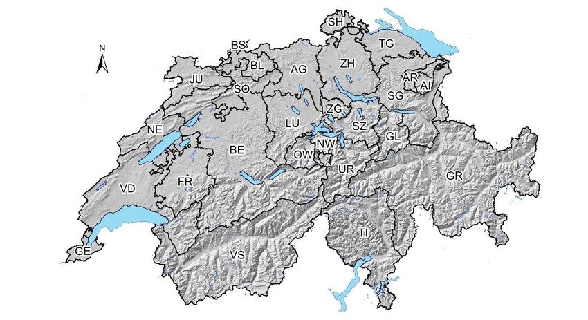
ESPON // espon.eu 9TARGETED ANALYSIS // DIGIPLAN – Digital plans and plan data in Switzerland 1.1 The Swiss planning system and the land use plan Switzerland's administration is organised in federal, cantonal and municipal authorities (Map 1.1). In the field of spatial planning, the Federal Constitution gives the Swiss Federation the responsibility of establishing basic principles for spatial planning. This is implemented in the Spatial Planning Act, which acts as a frame- work law and was last revised in 2014. Map 1.1 Switzerland and its cantons TG Thurgau, BS Basel-Stadt, NE Neuchâtel; for a legend for full names of Cantons see: http://kantone-staedte.infos- schweiz.ch. Source: own compliation The cantons are responsible for spatial planning on their territory, but most delegate land use planning to the municipalities. The Spatial Planning Act requires that activities with a spatial impact must be coordinated. Activities with spatial impact are defined as the settlement of the land or the use of the land. The distinction between building and non-building areas is central in this context. The most important instruments in Swiss spatial planning are the structure plans and the land use plans (Figure 1.1). The cantonal structure plans are prepared by the 26 cantons and approved by the federal government. They contain objectives and actions for appropriate spatial development, which must be considered by the com- munes. The cantonal structure plans consist of a map showing the relevant areas and a text section explain- ing the specifications. In subsequent land-use planning, the guidelines in the structure plan must be consid- ered and respected. The land use plan (also known as the zoning plan) is based on cantonal law and is the responsibility of the 2202 municipalities (number of municipalities for date 1.1.2020). In the plan, zones are defined for, for ex- ample, building, agricultural and protected areas. The land use plan is binding on landowners. As part of land use planning, there are special district plans (Gestaltungspläne) for local specification or to replace the general land use planning. The federal government can deal with issues of national interest in sectoral plans and concepts. These include topics such as transport, military or geological repositories. 10 ESPON // espon.eu
TARGETED ANALYSIS // DIGIPLAN – Digital plans and plan data in Switzerland

Figure 1.1
Spatial planning instruments under the Federal Law on Spatial Planning

  Federation                  Elaboration of basics
                              e.g. - Spatial concept of
                                     Switzerland                                       Concepts and
                                   - Strategy for spatial and                          sectoral plans
                                        transport development
                              and sustainable development

  Canton                      Elaboration of basics
                              e.g. - Spatial model (Leitbild)
                                   - Spatial planning concept
                                   - Concepts, sectoral plans                          Structure plan
                              Cantonal structure planning

  Municipality                Elaboration of basics
  (exceptionally              e.g. - Spatial model (Leitbild)
                                   - Municipal structure
  canton)
                              planning                                                 Land use plan
                              Municipal land use planning

Source: (Generalsekretariat GS-UVEK), original in German, own translation in English

                                                                                              ESPON // espon.eu   11
TARGETED ANALYSIS // DIGIPLAN – Digital plans and plan data in Switzerland
2 Scope of digital plan data
The purpose of the PLR-cadastre is to provide the public with up-to-date and reliable information on public-
law restrictions on ownership (Table 2.1). The implementation of the PLR-cadastre is anchored in the Geoin-
formation Act, which was passed in 2007 and has been in force since October 2009. The cantons are re-
sponsible for maintaining the cadastre, which is why the information is published on cantonal geoportals. An
excerpt from the PLR for a particular property can therefore be obtained from the portal provided by the
cantons. Framework models have been developed for the digitisation of various themes for the implemen-
tation of the PLR, which are intended to harmonise the themes across cantons. Of the 17 themes in the
PLR-cadastre, one major theme is municipal land use planning. In the interviews, it was mentioned that
neighbouring countries consider the PLR cadastre as a good example of the state of the art.
Table 2.1
Important portals associated with geodata and digital plan data in Switzerland
Name Description Link to portal
map.geo.admin.ch Federal geoportal with data viewer https://map.geo.admin.ch/
Meta-Search-Engine for Geodata of https://www.geocat.ch/geonet-
geocat.ch
Switzerland work/srv/ger/catalog.search#/home
geodienste.ch Aggregation-portal for cantonal data https://geodienste.ch/
Portal for open government data in
open data swiss https://opendata.swiss/de/
Switzerland
Cadastre of Public Law Restrictions on https://www.cadastre.ch/en/oereb.html, with
PLR Cadastre
Landownership links to cantonal portals
By the end of 2019, all cantons should have had put the PLR-cadastre into operation and made it available
via a cantonal portal. There is some delay in some cantons but the PLR-cadastre will be available in the next
few years (Figure 2.2.). In the canton of Thurgau, for example, all 80 municipalities have digitised their land
use plans and made them available in the PLR-cadastre. However, the geodata shown is not legally binding
and differ from the legally valid stamped analogue plan. In comparison, the geodata in the PLR-cadastre in
the Canton of Basel-Stadt are legally binding.
It is up to the Cantons to define in their acts how and if digital plan data is legally binding. In the canton of
Thurgau, the 17 main public-law restrictions on ownership under federal law are available in the cantonal
WebGIS, among them the land-use plan. However, it is not the geodata that is legally binding, but in the
case of land-use planning, the printed, signed and stamped plan. The digital plan data is so far, in a legal
perspective, only a representation of the signed plan. Because there are differences between the modifiable
digital data and the legally binding plan, the Geo2020 project was started in the canton of Thurgau in order
to shift the legal status to the digital data. One of the main differences so far is that there is no authentication
(Beglaubigung) in a PLR extract in the canton of Thurgau. However, it is anticipated that with the implemen-
tation of the project the discrepancies between digital geodata and analogue plans will be eliminated.
Similar to the canton of Thurgau, the land use plans signed in an analogue form are still legally binding in
the canton of Neuchâtel. In Neuchâtel, there are also efforts to assign legal validity to digital data. The canton
of Basel-Stadt has already achieved this step, with the geodata being legally binding. The cantonal experts
mentioned the canton of Bern as another example. In this case, the Canton requires the municipalities to
revise their land use plans before they can be included in the PLR cadastre. This provides an up-to-date
basis to ensure that the plans are in conformity with the current situation. In general, the interviews revealed
a general trend that more and more cantons are moving towards legally binding geodata in the PLR cadastre.
12 ESPON // espon.euTARGETED ANALYSIS // DIGIPLAN – Digital plans and plan data in Switzerland
Figure 2.1
Status of the PLR Cadastre
Dark green means that the PLR register is active and available. Light green shows that the PLR register is planned. White
colour indicates that the introduction of the PLR-cadastre has not yet been announced.
Source: https://www.cadastre.ch/de/oereb.html, accessed 12 Nov 2020
At the beginning of digitisation, the canton of Thurgau just got analogue land use plans from the municipali-
ties and therefore digitised them for internal use. Currently, municipalities deliver land use plans analogously
and digitally to the canton. For its own practice, the Canton of Thurgau uses only vector-based digital plan
data, which are managed by the Cantonal Office for Spatial Development (ARE TG).
In the canton of Neuchâtel, there are two portals, the PLR cadastre portal and a geoportal with more com-
prehensive data sets. It is possible to take an excerpt from the PLR-cadastre on both portals. The mainte-
nance of the digital data is also identical. In the canton of Neuchâtel, a revision of the land use plans is taking
place, which is due to the age of the plans. As the expert reported, the cantonal spatial planning law stipu-
lates that the digital plan data of the land use plans will become legally binding after the current revision
(addressed also in chapter 4.4 Process change).
“In my opinion, digital plan data cover planning practice to a small extent, but with a growing
tendency. [...] More efforts are made to use digital plan data in planning processes” (CH05).
At present, digital plan data are not yet widely used in planning practice, as shown above in the quotation of
an expert of national planning. There are great efforts to use digital plan data more in the planning process.
There is also a growing desire for a comprehensive land use information system (CH05).
ESPON // espon.eu 13TARGETED ANALYSIS // DIGIPLAN – Digital plans and plan data in Switzerland 2.1 The historical background Switzerland An experienced spatial planner reported that digitisation has increasingly occurred in Swiss spatial planning, both in terms of land use planning and cantonal structure plans. In this context, the minimal geodata models of the federal government were a major milestone, which was also mentioned by the Federal Office of Spatial Development (FOSD) expert. These data models provide the basis for harmonised digital plan data. The Geoinformation Act as the basis for the PLR cadastre has also contributed to digitisation. The expert from the FOSD mentioned that the awareness and the understanding of the added value of digital and structured data are important drivers for digitisation. In addition, developed data models of current pro- jects were mentioned as a milestone. It should be noted that there are often no technical requirements (Formvorschrift) for data models. Thus, the method of conversion in a programme (software) or the format- ting of a number is not specified. This could lead to a variety of implementations in software and therefore demands an agreement on unified implementation. The acceptance and appreciation of a formal regulation is therefore desirable as a further next milestone (CH05). Looking broadly at Switzerland, the picture arises that the legal framework to digitise for PLR, combined with a time limit, have contributed significantly to the current state of digitisation, according to the spatial planning expert. However, digitisation began in larger cities and by innovative planning offices. Thanks to the existing people and resources of the cantons, the digitisation of plan data in the cantons but also in the municipalities has been pushed forward. In Switzerland, digitisation is thus a combination of top-down and bottom-up pro- cesses. Thurgau, Basel-Stadt, Neuchâtel The experts from the canton of Thurgau mentioned that in 1996 the first topics were digitised from the can- tonal structure plans. Other themes from the cantonal structure plans were later also digitised and saved as vector data. Before 1996, however, only analogue data from the cantonal structure plans were used. The canton of Thurgau is now only working with geodata relating to the cantonal structure plans. The decisive factor was the initiative of the head of the office, whereby he expected an increase in efficiency through digitisation. The idea of increasing efficiency was a significant driver for the digitisation of cantonal structure plans. The digitisation of spatial planning in other cantons had little impact on digitisation in the canton of Thurgau. Similarly, the digitisation of the cantonal structure plans in Thurgau had little impact on the digiti- sation of municipal data in Thurgau, as the scale of the structure plans is not focused on parcels and is not directly included in the land use planning. In 2002, the GIS Association Thurgau (GIV) was founded and located at the Cantonal Office for Geoinformation. This association is responsible for geoinformation be- tween municipalities, canton and private sector with several working groups. The land use planning working group made a major contribution to the development of a cantonal data model. This initiative prompted about 80% of the municipalities to digitise their land use plans. Acceptance was not a problem, as the municipalities had recognised the advantages of digitisation. The Geoinformation Act (2007) as the new legal basis initiated the digitisation of land use plans of the last remaining 20% of the municipalities. Thus, the land use plans in Canton Thurgau had already been digitised before the introduction of the PLR cadastre in 2012-2015. How- ever, the PLR cadastre then formed the connection to the legal regulations. In terms of the PLR cadastre, the Canton of Thurgau made good progress, with the Office for Geoinformation playing a major part. As a result, the implementation of the PLR cadastre in the Canton of Thurgau is also an interesting example for other cantons. The cantons can use the digital data of the municipalities from the PLR cadastre to analyse the extent of building zones, a task it needs to perform for updating the cantonal structure plan. At present, there are still some inconsistencies in the digital data, which need to be corrected by the Office for Spatial Development in the canton of Thurgau. Before the PLR cadastre, however, the cantonal office for spatial development in the canton of Thurgau (ARE) digitised municipal plans at considerable effort to determine the settlement area. It was noted that the data of these digitised plans was of lower quality than it is today (CH02). In the canton of Basel-Stadt, digitisation in the public authorities began in the 1990s. Digitisation of plans made it easier to handle the plans. This and also the easier accessibility through digitisation were mentioned in the interview as drivers of digitisation. In the years 2013 to 2015 the digitisation of the entire historical plan data was started. A start was made first with the historic photos of buildings, which would otherwise rapidly 14 ESPON // espon.eu
TARGETED ANALYSIS // DIGIPLAN – Digital plans and plan data in Switzerland

lose quality. The historical plans are in the process of being scanned, labelled and then saved. A georefer-
encing of these plans does not occur. The historical plans are digitised over time, whereby data of entire
neighbourhoods will gradually be digitised. In the process of digitisation, various experiences have been
made, whereby the storage of different versions of digital plan data played a lower role at the beginning than
it does now. Today, due to the possibilities of digitisation, the amount of data has increased. This has also
been noticed in the pictures, which were taken in the context of planning projects. In the past, one or two
pictures would have been sufficient, whereas today, due to the ease of use, multiple photos are taken.

In the canton of Neuchâtel, digitisation in cadastral surveying began in the 1990s. In the 2000s, the land use
plans were first digitised by the spatial planning office for internal use, using the data of the official cadastral
survey as a basis. In 2010/2011, this development led to the Canton of Neuchâtel participating as a pilot
canton in the PLR Cadastre project. Most of the plan data had already been digitised. What was still missing
was the link with the regulations for the PLR cadastre, which required considerable effort. Over the last one
and a half years, the focus has been on revising the land use plan and adapting the legal basis to make the
digital data legally binding.

2.2 Standards
Standardisation is particularly important for land-use planning and brings great added value in the analysis
throughout Switzerland (CH01).

Since the PLR cadastre is a cadastre of legal restrictions, international standards did not play a role in the
implementation of the cadastre. The expert on the PLR-cadastre said that this degree of linking geodata and
legal information is unique so far. However, a European working group once held an exchange on the im-
plementation of different PLRs in the various countries (Steudler, 2016). As with the PLR cadastre, interna-
tional standards, i.e. INSPIRE in particular, did not have much influence on the federal framework models,
as the expert from the FOSD stated. Nevertheless, data management and the concept of the life cycle of
geodata were included, for which INSPIRE was the inspiration. The expert from the Office for Geoinformation
in the Canton of Thurgau also mentioned that he had not yet had any contact with INSPIRE.

The canton of Thurgau has a cantonal data model for land use planning, which was implemented 10 years
ago. This was adapted with the introduction of the federal minimal geodata models and the framework mod-
els of the PLR cadastre. The municipalities are responsible for classifying their zones into the cantonal
model. This cantonal model is also shown in the PLR cadastre. The canton then handles the assignment of
the cantonal data model to the minimal geodata model of the federal government. The expert from the Office
for Spatial Development of the Canton of Thurgau estimated that the national minimal geodata models are
certainly more efficient and more meaningful than 26 individual solutions with different interpretations. How-
ever, it must be considered that such a national data model was a great effort in Switzerland, involving many
working groups and intensive discussions. The expert from the Office for Geoinformation also mentioned
the importance of standardisation and harmonisation for the comparability of data. Currently, many digital
plan data are already available in geoportals, but are not yet comparable. Harmonisation at cantonal level
for the cantonal structure plans is therefore also in progress. However, there is always the question of how
much influence a higher level (federal government) can and should have on the lower level (canton). How-
ever, a cantonal planner (CH07) expects that standardisation and harmonisation for comparability will con-
tinue to increase in Switzerland. Due to the different interests, an attempt is being made to find the lowest
common denominator, which can be agreed on (cf. quotation below).

       “In the future, there will certainly be a move towards harmonisation and standardisation. In the
                         end we will have to agree on the lowest denominator” (CH07).

Like the canton of Thurgau, the canton of Neuchâtel also has a cantonal data structure. This is based on the
national minimal geodata model. In the current revision of the land use plan, new land-use plans based on
the existing data are being produced with the new standards of the canton of Neuchâtel. The PLR cadastre
also shows the cantonal data structure of the land use plans (CH06).

In the canton of Basel-Stadt, plan data is exchanged between Germany and Switzerland for international
projects such as IBA Basel or Landschaftspark Wiese. Since the Swiss data comply with the federal minimal
geodata models and the German data also meet certain requirements, this does not present a problem.

                                                                                             ESPON // espon.eu   15
TARGETED ANALYSIS // DIGIPLAN – Digital plans and plan data in Switzerland However, the different data resolution in the three countries Switzerland, Germany and France is a challenge for the international presentation of regional plans (CH04). 16 ESPON // espon.eu
TARGETED ANALYSIS // DIGIPLAN – Digital plans and plan data in Switzerland

3 Organisation of digital plan data
3.1 Organisation
Federal minimal geodata models
The Geoinformation Act has been in force in Switzerland since 2008. This law requires federal minimal
geodata models and geodata illustration models in order to allow a broad use of geoinformation (Bundesamt
für Raumentwicklung ARE, 2020a). A federal minimal geodata model was also established for land-use
planning. The cantons are required to provide the federal government with the relevant data so that the
federal harmonised data set can be published on the national geoportal1. Currently a model is being devel-
oped for a nationwide dataset of the cantonal structure plans. For this reason, the federal government and
the cantons are currently discussing how to ensure that the cantons can commit to them on a voluntary basis
as far as possible (CH05).

Federal sectoral plans
Sectoral plans show national strategies in specific sectoral or thematic areas. The Federal Government can
thus show objectives and requirements or targets in the sectoral plans (Bundesamt für Raumentwicklung
ARE, 2020b). The sectoral plans are digitally available as vector data with the corresponding object sheet
on the national geoportal (CH05).

Cantonal structure plans
The cantons are responsible for developing the cantonal structure plans, which is why they are also respon-
sible for digitisation. The expert from the canton of Thurgau commented that the digitisation and digital prep-
aration of the cantonal structure plans was carried out independently of the other cantons (CH07).

Municipal land use planning
The municipalities are responsible for land use planning. Thus, the municipalities maintain the freedom to
name and define their use zones themselves (within cantonal limits). However, these must be transferable
into the optional cantonal model and into the minimal federal geodata models (CH02). In some of the cantons
studied, the land use planning data in the PLR cadastre are shown in the cantonal data model (Thurgau,
Neuchâtel).

Cadastre of Public Law Restrictions on Landownership (PLR Cadastre)
The Geoinformation Act legitimises the PLR cadastre. Framework models were created for the presentation
of the data in this cadastre. A degree of harmonisation was intended to ensure a minimum level of compa-
rability of the data throughout Switzerland. The PLR cadastre represents the public-law restrictions on own-
ership, which can be found in the land use planning, for instance. However, the planning processes for land
use planning are not controlled by the PLR cadastre, but take place in the usual planning processes. Nev-
ertheless, the PLR-cadastre represents a change, as the information is presented separately in the PLR-
cadastre in accordance with the legal basis (cf. quotation of a PLR expert below; CH03). The management
and organisation of the legal texts in the context of the PLR-cadastre is the responsibility of the cantons.

          “The implementation of the PLR cadastre requires a rethinking. [...] With digitisation, we are
          moving away from this presentation because the information can be overlaid separately and
          viewed individually. In order to make the different legal bases visible, the topics for the PLR
         cadastre are separated. In this way the legal processes can be assigned more easily.” (CH03)

1
    https://map.geo.admin.ch

                                                                                             ESPON // espon.eu   17
TARGETED ANALYSIS // DIGIPLAN – Digital plans and plan data in Switzerland
The PLR cadastre is based on the Geoinformation Act (data act) and various other laws, for example the
Forestry Act (act for specific topic in PLR). There are discrepancies between these specialised and data
laws. A major point of discussion is the legally binding nature of the data. The PLR cadastre can be used by
cantons as an official publication organ. However, this is not prescribed in the federal legislation; the cantons
have the freedom to implement this within the framework of their own legislation. In the example of spatial
planning, land-use planning is regulated by cantonal legislation. The question therefore arises as to what
extent a national data law can intervene here. Is it permissible to prescribe a details of implementation on
the basis of the harmonisation mandate in the context of the Geoinformation Act? For example, the water
protection law restricts the construction near water bodies. The regulation does not yet clarify how the dis-
tance to the water body is to be represented geometrically. On the one hand, the distance could be a line or
on the other hand, an area. This detail and others are currently the subject of discussion (CH03). The various
laws concerning the public law restrictions on a parcel are displayed as a whole in the PLR cadastre and
must fit together. However, it is not yet possible to display all specific texts for a parcel. The question arises
of how this can be implemented, since the legal texts unfold their effect as a whole (CH05).
The canton of Thurgau was a pilot canton in the development of the PLR cadastre. The development of an
administrative management tool, ÖREBlex, has played a major role in this process, with the three categories
of “legal regulations”, “notices and legal bases” and “notices” being represented (CH03). The Canton of
Thurgau, as well as many municipalities, now use this tool to manage information on legal bases in the
context of PLR content (building regulations, laws, federal and cantonal ordinances). In this administration
tool, there is a link to cantonal and federal legal texts, whereby adjustments are automatically transferred. It
also contains historical information and regulations. Only the municipal legal foundations are managed man-
ually and reported by the municipalities, which is a possible source of errors (CH02). However, this tool has
proven to be helpful, which is why it is now used by more than half of the Swiss cantons (CH03).
In the Canton of Thurgau, conflicts between the Data Act (Geoinformation Act) and the specialised law
(Spatial Planning Act) were also identified, with the main point relating to the legal validity of digital data. The
canton is now in the process of adapting the specialised legislation in order to eliminate the difficulties of the
two legal bases. Furthermore, the expert noted that the distribution of tasks among the authorities has
changed to a certain extent as a result of digitisation. However, this is not regulated by law. The Canton of
Thurgau, for example, is taking over the task of updating the building zone reserves for the municipalities
for the municipalities by consulting the PLR data (CH07, more on this in section 3.3).
In the canton of Neuchâtel, the coordination of specialised legislation with data legislation works well be-
cause the offices in the canton work well together. The legal bases in the PLR cadastre for the land use
plans, i.e., the municipal building regulations, were captured manually at considerable expense. These doc-
uments are now good working documents. The canton uses a web solution to link these documents with the
geometry. This is then checked by the spatial planning office. With the current revision, the latest documents
and currently valid plans are identified. Even though it is possible to certify the PLR cadastral excerpt in the
canton of Neuchâtel, this has never been requested. Due to the exact quality, the data are used as if they
were legally binding (CH06).
3.2 Financing
Digital data production is usually financed by the data owners themselves, as the expert from the FOSD
said. The municipalities are responsible for land use planning, the canton for cantonal structure plans and
the federal government for sectoral plans or national topics.2 However, the regulation of data management
differs from the regulations of data production in Switzerland and depends on the canton. The FOSD expert
also noted that end users pay less for the provision of digital plan data compared to the past. If the data sets
require payment, then the price of the data does not cover the data itself, but instead covers the preparation
of the data for the individual delivery, as stated below by a planning expert at national level3.
2
An exception is the digitisation and production of a digital data set on sustainable energy. The Swiss Federal Office of
Energy is interested in these data and therefore co-financed the digitisation of these plans.
3
As mentioned in section 1, the Swiss parliament approved the OGD strategy in December 2020.
18 ESPON // espon.euTARGETED ANALYSIS // DIGIPLAN – Digital plans and plan data in Switzerland
“The whole Open Government Data (OGD) movement, which the administration has cap-
tured, requires less effort, there is no longer the need to draw up contracts, but rather the in-
formation is placed on the internet where users can obtain it. [...] Therefore, the costs for the
end users are decreasing. There is data that has to be paid for [...], but you pay less and less
for the data as such but for the preparation of it.” (CH05)
The financing of the PLR cadastre was regulated in a way that the infrastructure and the digitisation of the
plan data were considered separately. Since the federal government had expected the cantons to digitise
their planning data before the PLR cadastre was established, as the expert noted (CH03), financial support
was only granted for the additional costs arising from the Geoinformation Act, i.e. the infrastructure of the
PLR cadastre. The swisstopo expert explained that the federal government and the cantons each contrib-
uted half of the financial support to the PLR cadastre.
The experts from the canton of Thurgau reported that the municipalities themselves financed the digitisation
of the land use plans. As the municipalities also see added value in the digital data, digitisation at the ex-
pense of the municipalities did not present a problem. Often the municipalities work together with private
planning firms and pay them to produce the plans. The municipal data are delivered to the canton to be
incorporated into the cantonal data model. Since there are still some errors in the assignment to the cantonal
model, the canton has to correct these errors, which takes time and human resources. However, these costs
should decrease in the future. The digitisation and production of cantonal data is financed by the canton.
The costs in the canton for these cantonal issues consist mainly of the time spent by the cantonal employees
on producing data sets for the cantonal structure plans. The updating of the data is also carried out within
the canton. Depending on the topic, this is done by the individual departments or by the Cantonal Office for
Spatial Development.
The expert from Basel mentioned that the Land Register Survey Office (Grundbuchvermessungsamt) is
responsible for organising the financing of land use plans. Within the canton, the data is accessible at no
cost.
The first digitisation of land use planning in the canton of Neuchâtel was financially supported by the canton
and the pilot project of the PLR cadastre. The canton assumed the financing on the basis of compliance with
certain data formats and guidelines issued by the Cantonal Spatial Planning Office. The municipalities did
not need to spend anything on this apart from resources for checking the data. However, the current revision
of the land use planning is at the expense of the municipalities. The storage and maintenance of geodata is,
however, the responsibility of the canton, which also covers the costs. The two geoportals in Canton Neu-
châtel are accessible for free. However, the purchase of data for third parties comes with a small adminis-
trative fee in Canton Neuchâtel.
3.3 The role of different actors
Digitisation
The expert from the canton of Thurgau reported that the cantons submit cantonal data sets to the federal
government so that the federal government can compile a national data set. Here, the recently discussed
question arises of how a communal data set can reach the federal government if a commune does not agree
to supply the data. Can the federal government contact the municipality directly, or how does the canton
deal with this? Digitisation has shown that the allocation of responsibilities in digital spatial planning in Swit-
zerland is complex (CH07). The spatial planning law defines the thematic competence. As a result of digiti-
sation, it can happen that municipal data is collected by the canton and delivered to the federal government,
although the municipalities would actually be responsible for it. Such roles are currently still being clarified.
In the canton of Thurgau, however, this has so far not caused any conflicts, as the issues have been con-
sidered jointly by the canton and the municipalities and solutions have been found (CH07).
In the canton of Neuchâtel, the canton played a leading role in the first digitisation of the municipal land use
plans. The canton now also initiated the revision of the land use plan. Nevertheless, the municipalities are
responsible for the implementation of the current revision of the land use planning. The canton then controls
and validates the land use planning and also manages the digital data. The expert concluded that municipal
autonomy in this French-speaking canton in land use planning is smaller compared to municipalities in Ger-
man-speaking Switzerland (CH06).
ESPON // espon.eu 19TARGETED ANALYSIS // DIGIPLAN – Digital plans and plan data in Switzerland
Standardisation
Standardisation is needed to ensure comparability. For the corresponding data models, a consensus of the
authorities is crucial (CH05). The public authorities, in particular the Federal Office for Spatial Development,
played an essential role in the standardisation of spatial plan data. For national comparability of plan data
there are the federal minimal geodata models, whereby the federal government plays a leading and central
role (CH01). The interviews showed that cantons use a cantonal data structure, in which for example the
data of the land use planning in the PLR cadastre are shown (CH02, CH06). A planning expert at national
level expressed it as follows:
“Where there is no formal requirement, which has been found in a consensus, then this (con-
sensus) must be found first. This is crucial. Cantons, regions, agglomerations, municipalities -
these are of course stakeholder number 1. They have to agree with the draft/data model.
Their role is very important, and it is essential that they are consulted.” (CH05)
In the standardisation and harmonisation of cantonal and municipal data, the respective responsibilities of
the authorities must be defined. It is currently being clarified how much influence the federal government
can have on cantons and cantons on municipalities to demand standardised data, although the technical
responsibility lies with the lower level of authorities (CH07).
It was mentioned in the interviews that the different data collection methods must be considered when inter-
preting cantonal data sets. In the example of the crop rotation areas (Fruchtfolgeflächen), the data were
collected slightly differently in the individual cantons, which makes comparability impossible. This must be
taken into account when interpreting the data. This is particularly noticeable when the data is published and
accessible to everyone. There is thus a risk that this easy availability could lead to incorrect data interpreta-
tions. Authorities have little control over this (CH07).
PLR cadastre (Public law restriction)
The PLR cadastre is based on the Federal Geoinformation Act. However, the implementation thereof, e.g.
in land-use planning, is regulated by cantonal legislation. The federal government can only give recommen-
dations. The cantonal regulations and recommendations apply to the handling of the PLR cadastre in the
cantons (CH03).
3.4 Relation within different levels of government
In the context of his work, an expert in spatial planning has noticed that the dialogue between the cantons
is very important during the digitisation process. This dialogue is supported, for example, by the cantonal
planners' conference where all cantonal planning directors regularly meet. The expert also sees the oppor-
tunity that cooperation within the authorities could be facilitated by simplified digital processes. Furthermore,
cooperation between the authorities is on a good path and a lot is already in progress. However, cooperation
could be a challenge for the municipalities, as they are often faced with resource scarcity. This is due to the
militia system in the Swiss municipalities, since most municipal politicians work for the municipality only on
a volunteer or part-time basis (Schweizerischer Gemeindeverband, 2016). In particular, small to medium-
sized municipalities need support and networks for regional exchange. The association of towns or munici-
palities could play a stronger role in this. According to a spatial planning expert, exchanges between the
cantons take place through cantonal events or directly on a bilateral basis (CH01):
“The exchange of experience between the cantons is very valuable. Regular exchanges take
place in the relevant working group of the Cantonal Planners' Conference, where problems
and open questions are discussed. This exchange already existed before digitisation, but was
also helpful for questions concerning digitisation. Good examples could be shared. Especially
for land use planning, the exchange was very useful” (CH01)
The swisstopo expert noted that the digitisation of plan data has not significantly changed the structure of
relations between the authorities, as the information in the PLR cadastre is public and accessible to all.
However, digitisation had consequences on all administrative levels in cleaning up their data stocks to deliver
20 ESPON // espon.euTARGETED ANALYSIS // DIGIPLAN – Digital plans and plan data in Switzerland
the current data (CH03). The FOSD provided support in its cooperation with the cantons in establishing the
PLR cadastre. The Specialist Information Communities (Fachinformationsgemeinschaften (FIG)) are mainly
responsible for technical specificities in the interaction of the federal government with the cantons (CH05).
On a more conceptual level, the exchange between the federal government and the cantons takes place
either through the federal offices themselves or through the federal Coordination, Geo-Information and Ser-
vices (KOGIS). The expert also mentioned that the cooperation between the Federal Government and the
cantons has changed due to the federal minimal geodata models. As the Federal Government demands
more information from the cantons in connection with these data models, its influence on the cantons in-
creases accordingly. In the same way, the influence of the canton on the municipalities has also increased,
as the canton demands information from the municipalities, which is then passed on to the federal govern-
ment.
The GIS Association Thurgau (GIV) was cited by an expert as a successful model for cooperation between
municipalities, cantons and the private sector. The network contributes significantly to raising awareness
and clarifying issues and can also be seen as a driver for cooperation, as the expert pointed out:
“The GIS Association Thurgau (GIV) has been in existence for 15 years and during this time
has coordinated the cooperation in the context of digitisation with the municipalities and the
canton. It has also sensitised stakeholders and clarified questions. In my opinion, the GIS as-
sociation is a successful example. The association is a driver for cooperation with the munici-
palities” (CH02)
In the canton of Neuchâtel, cooperation within the authorities was already well established before digitisa-
tion. Digitisation resulted in a greater practice of communication, which increased transparency within the
cantonal administration. In addition, the communes and the canton cooperate well, which was intensified by
the data collection (CH06).
The expert from the canton of Basel-Stadt reported on international cooperation with GeoRhena and the
neighbouring countries Germany and France. The expert noted that data quality differs, with France having
much less detailed plan data than Germany and Switzerland. Thus, despite good cooperation, a joint presen-
tation is difficult. Nevertheless, the German land use plans have an indirect influence on planning in the
canton of Basel-Stadt. For example, the canton was able to plan an urban railway because of its knowledge
of the development plans in Germany (CH04).
3.5 Relation between governmental and not-governmental actors
A spatial planning expert said authorities will become more transparent due to the easier accessibility of
digital plan data. Increased participation can also be assumed due to the easy accessibility. According to his
experience, however, the interest of people in the plan data is not directly linked to digitisation, but rather to
the affected area. However, the digital possibilities make participation easier. The canton of Obwalden was
cited as an example, which had already carried out the public participation process for the last cantonal
structure plan revision digitally. However, when publishing digital plan data, the expert mentioned that third
parties sometimes do not know which data can be found where. But once this is better known, the expert
expects improved cooperation (CH01). The expert from the FOSD also reported on a more intensive ex-
change with the population due to the publication of digital plan data. This, in turn, increases transparency
through better visibility of the authorised pans (CH05).
Due to the public and easy access of the data in the PLR cadastre, the interest of the real estate market,
notaries and banks in the information in the PLR cadastre is high. The real estate market benefits from this,
as it facilitates access for their risk assessment and valuation of properties. Banks and insurance companies
are also very interested in this information (CH03).
In the canton of Thurgau, it was observed that private companies (planning firms etc.) are more progressive
than the municipalities, as they have to position themselves on the market and therefore take advantage of
consulting opportunities. The expert therefore assumed that the influence of these private companies has
increased. It should also be mentioned that the general population has easier access to digital plan data. It
was therefore noted that the public is becoming more aware of the issue of digital plan data. The participation
processes for citizens in the canton of Thurgau still take place in analogue form. In future, the aim is to
manage participative processes digitally. In terms of cooperation, the GIS Association Thurgau (GIV) should
ESPON // espon.eu 21TARGETED ANALYSIS // DIGIPLAN – Digital plans and plan data in Switzerland
be mentioned, as it has so far proved to be advantageous for all parties involved. This association includes
not only the authorities but also private planning companies. Cooperation between public and private sector
is illustrated below in the comments of a PLR and a planning expert.
“The private sector is technically more advanced than the municipal administration (canton of
Thurgau). In the canton of TG there are many small municipalities which are generalists and
not specialists. The private sector supports the municipalities because they are specialists
and they know what is state-of-the-art. And they have taken the opportunity to advise the mu-
nicipalities. The municipalities listen to them too. Since the private sector is more advanced
than the public authorities, it has gained influence” (CH02)
“Planning becomes more transparent thanks to the digital data and easy accessibility. This
makes it easier for private individuals, landowners and also consultants to access information.
Since this digital information is public, the position of all actors has been strengthened.”
(CH01)
The expert from the canton of Basel-Stadt mentioned that events for participation in urban district plans are
highly appreciated and valuable. At these events, anyone can take a position and a discussion is initiated.
The expert found the discussion in digital chats more challenging. It was also noticed that the preference in
which medium the discussion takes place could differ from generation to generation (CH04).
In the canton of Neuchâtel, cooperation with private individuals is managed by the spatial planning office.
However, this has not changed significantly as a result of digitisation (CH06).
22 ESPON // espon.euTARGETED ANALYSIS // DIGIPLAN – Digital plans and plan data in Switzerland
4 Use of digital plan data
4.1 Use of digital plan data in different planning processes
Digital plan data can be used in many different ways. They can be used in formal planning as well as in
informal processes or analyses.
Formal planning process
The FOSD expert said that digital plan data is used in the formal planning process for information and com-
munication via the internet. However, this is the responsibility of the responsible local authorities, and there-
fore this can be implemented in different ways (CH05). In the canton of Neuchâtel, the digital data of the
land use planning are used as if they were legally binding. This is possible because of the adequate data
accuracy, although the digital data is not yet legally binding. (CH06).
Informal planning process
There is potential to use digital plan data in informal planning so that, for example, evaluations of it can flow
directly into the planning process. Today, data exchange in plan data design processes is not yet anchored
in the process itself. In the future, however, data could be used in such a way that it can directly change the
drafting process (CH05).
Evaluation of planning
The digitisation of plan data offers the possibility to use this digital data for the evaluation of planning (more
on this in Annex 3, Thematic Practice Paper "Future technical developments and possibilities"). Digital plan
data is used for monitoring at federal level in Switzerland. For example, digital plan data is needed to exam-
ine the building zone dimensioning of the municipalities and thus incorporate it into the subsequent planning
(CH05). In the canton of Basel-Stadt on the other hand, digital plan data is also used for urban development
and prognoses of development (CH04).
Further use
The municipal plan data is important for the Canton of Thurgau for establishing monitoring the current level
of accessibility (road, public transport) and planning future extensions. Private actors are also interested in
the digital plan data. For example, the Swiss Federal Railways (SBB) or a mobile network provider Swisscom
can benefit from the data and use it for their own purposes (CH02). By publishing the plan data on the
internet in the canton of Basel-Stadt, the data can be used in a variety of ways. Thus, research, nature
conservation and associations can also acquire the data via the Geoshop and use it for their purposes
(CH04). The expert from the canton of Neuchâtel also noted that the digitisation of plan data creates new
needs and requirements. This also opens up many new possibilities for use (CH06).
In the canton of Thurgau, the data on building zone reserves is used as a parameter for the cantonal structure
plans. Raum+ is a method for creating overviews of settlement reserves4. Therefore, the canton of Thurgau
joined the Raum+ project to survey their building zone reserves, with the first basic survey taking place in
2014. The ARE expert (CH07) explained that the results were criticised because the building zone reserves
could not be digitised in parcel detail at that time. In fact, the zones were drawn on an analogue paper plan
in a survey meeting and subsequently digitised. During the first update in 2018, however, a more accurate
data quality was achieved, as the data basis was based on digital data. This also resulted in greater ac-
ceptance by the municipalities, as the expert reported. Since a revision is planned every four years, the third
revision is planned for 2022.
4
https://www.raumplus.ethz.ch/de/home/, access on 18.12.2020
ESPON // espon.eu 23You can also read