Community Wildfire Protection Plan - City of San Luis Obispo July 2019
←
→
Page content transcription
If your browser does not render page correctly, please read the page content below
Community Wildfire Protection Plan
              City of San Luis Obispo

                             July 2019
TABLE OF CONTENTS
EXECUTIVE SUMMARY ......................................................................................................... 4

SECTION I: UNIT OVERVIEW .................................................................................................... 6
   LOCATION ............................................................................................................................... 6
   LAND OWNERSHIP ................................................................................................................. 6
   POPULATION AND HOUSING ................................................................................................ 7
   FIRE ENVIRONMENT .............................................................................................................. 9
   VEGETATION / FUELS .......................................................................................................... 10
   TREE MORTALITY ........................................................................................................... 13
   WEATHER .............................................................................................................................. 14
   TOPOGRAPHY ................................................................................................................. 16
   FIRE HISTORY ....................................................................................................................... 17
   IGNITION HISTORY ............................................................................................................... 18
   PREPAREDNESS AND FIREFIGHTING CAPABILITIES ..................................................... 19

SECTION II: COLLABORATION .......................................................................................... 21
   COMMUNITY / AGENCIES / FIRE SAFE COUNCILS / FIREWISE COMMUNITIES............ 22

SECTION III: VALUES ......................................................................................................... 24
   VALUES ............................................................................................................................ 24
   FIRE RISK vs. FIRE HAZARD ............................................................................................... 25
   PRIORITY COMMUNITIES ................................................................................................ 25
   PLANNING AREAS ................................................................................................................ 26
   CRITICAL INFRASTRUCTURE/CULTURAL/BIOTIC ASSETS ............................................ 27
   COMMUNITIES ...................................................................................................................... 28

SECTION IV: TACTICAL POLICY MATRICES ..................................................................... 29
   EDUCATION ........................................................................................................................... 29
   FUEL ....................................................................................................................................... 31
   PLANNING ............................................................................................................................. 34
   RESPONSE ............................................................................................................................ 36
   IGNITION RESISTANCE ................................................................................................... 38

                                                                     I
                                                                 July 2019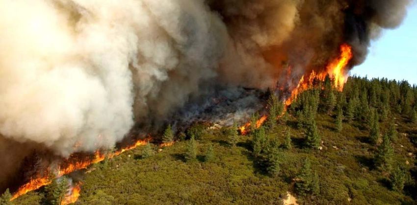
ACKNOWELDGEMENTS

This Community Wildfire Protection Plan is a guide to provide a community that is
prepared and resilient to the impacts of wildland urban interface fires.

Thank you to the San Luis Obispo County Fire Safe Council for their assistance in
providing the information and data to support this document.

OUR MISSION AND MOTIVATION

              Serving your safety needs is our Mission because we care.

OUR VISION

             Through thoughtful prevention and skilled, compassionate response, we
             create a safer environment for all who visit, work, and live in our amazing
             community.

OUR VALUES AND ETHICS

             The core values that guide our service to the Community include:
                   COURAGE, COMMITMENT AND COMPASSION.

             The core ethics that guide our service to each other include:
                   RESPECT, DIGNITY, HONESTY, COMPASSION, AND TRUST.

                                            II
                                        July 2019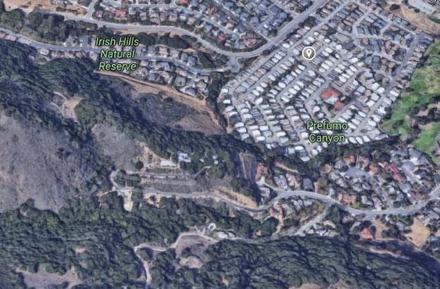
EXECUTIVE SUMMARY
This City of San Luis Obispo Strategic Community Wildfire Protection Plan (CWPP) is developed to
collaboratively address fire protection planning efforts occurring in the City, to minimize wildfire risk
to our watershed lands, assets, firefighters, and the public. It is developed to work cohesively with
the San Luis Obispo County Community Wildfire Protection Plan. This CWPP presents the City’s
physical and social characteristics, wildfire history, identifies and evaluates landscape-scale fire
hazard variables, utilizes priority landscape datasets for evaluating wildfire risk, identifies strategic
measures for reducing structural ignitability, public education and outreach, and identifies strategic
fuel reduction goals and techniques for minimizing wildfire risk. This CWPP is a living document
managed and updated routinely by the City of San Luis Obispo Fire Department with stakeholder
input and involvement.
The goal of this CWPP is to provide a citywide strategic planning level framework for hazardous fuel
assessment and reduction within the City of San Luis Obispo so that structures and assets are
provided additional protection, reducing the potential of ignitions. With consistent goals of improving
fire prevention and suppression efforts, reducing hazardous fuels, restoring fire-adapted
ecosystems, and promoting community assistance. The goals of this CWPP include: improving the
availability and use of information regarding hazard and risk assessment; providing guidance for
land use planning efforts; promoting a shared vision among communities and multiple fire
jurisdictions; establishing fire resistance in communities; prioritizing protection of communities and
other high-priority watersheds; promoting collaboration between government agencies and a broad
representation of stakeholders; improving fire suppression and prevention capabilities; promoting
post-fire recovery efforts; and maintaining accountability through performance based monitoring.
This CWPP will serve as the foundation document to interface local projects to reduce the
Community Wildfire Risk.
The development strategies of this CWPP are to create a City that is more resistant and resilient to
the damaging effects of catastrophic wildfire, while recognizing fire’s beneficial aspects. This CWPP
utilizes the following strategies to accomplish its goals:
Collaborate with stakeholders and allied agencies
Conduct and refine risk assessments for wildland urban interface (WUI) areas
Integrate wildfire community pre-attack plans
Foster community involvement in pre-fire planning efforts
Develop community outreach and education goals
Monitor the effectiveness of programs, projects and initial attack success
This CWPP, has been developed with the purpose of meeting the goals set in the San Luis
Obispo Community Wildfire Protection Plan while integrating the goals and objectives established
in the San Luis Obispo Strategic Plan. This CWPP prioritizes protection of the community, natural
resources, and the lives of the public and firefighters. This priority is shared among state and
local government, and other community stakeholders. Collaboration, establishing goals, priority
setting, and accountability provide the framework for the guiding tactical principles of this CWPP,
which include:
Increase the safety to residents and firefighters during wildland fires
Reduce the costs and losses associated with wildland fires
Support implementation of WUI building standards through coordination and
cooperation with the City of San Luis Obispo Planning and Building Department
Support the implementation and maintenance of defensible space around structures
Support project work and planning efforts that encourage the development
and/or maintenance of safe ingress and egress routes for emergency
incidents
Promote cooperation between fire agencies in the County to minimize wildland fire
damage through strategic fuel treatment, land use, and public outreach projects
4
July 2019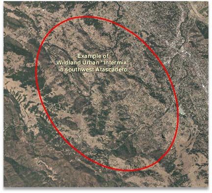
Utilize fire prevention efforts to reduce ignitions within the City
Conduct post-incident analysis to evaluate success in achieving the 95% threshold of
keeping fires less than 10 acres in size
Promote public education efforts about wildland fire through the support of the San Luis
Obispo County Community Fire Safe Council (SLO FSC) and Fire-wise community
activities.
This Plan provides planning information at a City-wide scale and recognizes the variation in fuels,
weather, topography, and community/agency priorities present in the City. It is intended to be a dynamic
planning tool for promoting wildfire protection efforts in the City. Additionally, this Plan is not intended to
satisfy the California Environmental Quality Act (CEQA) or regulatory permitting requirements and any
recommended projects or actions contained herein shall be subject to the appropriate permitting and
environmental review for the jurisdiction in which they are proposed.
5
July 2019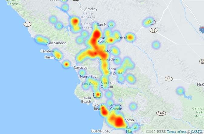
SECTION I: UNIT OVERVIEW

 This CWPP Plan covers San Luis Obispo, California. This section presents more detailed information about
 San Luis Obispo, specifically, a description of factors affecting wildfire risk within the City.

 LOCATION
 San Luis Obispo is situated on the Central Coast of California,
 approximately halfway between San Francisco and Los Angeles. San Luis
 Obispo is bordered by the un-incorporated areas of San Luis Obispo
 County. San Luis Obispo encompasses 8,404 acres and supports a
 population of approximately 47,541. Large population increases are
 common in the late spring and summer months from tourism. Fire protection
 in the City and Cal Poly University through contract is provided by the City
 of San Luis Obispo Fire Department with Automatic Aid Agreements in
 place with the CAL FIRE/San Luis Obispo County Fire Department. Mutual
 Aid is also provided within the operational area from CAL FIRE/San Luis
 Obispo County Fire Department and                 seventeen local fire
 departments/districts.

 LAND OWNERSHIP

Approximately 78.1 percent (7,639 acres) of the City’s total land area is developed
as residential, commercial, mixed use, industrial land, and public facilities uses.
The remaining land is made up of 2,448 acres (7.3 percent) agriculture and 14.5
percent parks and open space. Some open space included in the remaining land is
owned by the City but resides in the County adjacent City limits.

                                                   6
                                               July 2019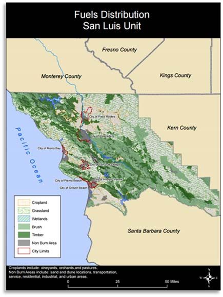
POPULATION AND HOUSING
The estimated 2019 population of San Luis Obispo is 47,541, a 5.3% percent increase since the 2010
U.S. Census. San Luis Obispo County has 7 incorporated cities with San Luis Obispo being the largest
city in the County.

The distribution of the population in San
Luis Obispo creates several different
conditions, each of which is unique to
pre-fire planning. Urban areas are
predominantly built-up environments
with little or no exposure to wildland
vegetation (fuels). The area where
urban      development     abuts     non-
maintained wildland fuels is known as
the wildland-urban interface (WUI).
Rural areas, as defined in the NWCG
Glossary of Wildland Fire Terminology
are “Any area wherein residences and
other developments are scattered and
intermingled with forest, range, or farm
land and native vegetation or cultivated
crops and open space”, More recently,
“wildland-urban intermix” is a term
being used to describe WUI areas
where the density of housing units and
structures is relatively low and the
space between consists of wildland
fuels capable of propagating fire. While
often used interchangeably when
discussing WUI issues, the difference
between the terms “interface” and
“intermix” is that the boundary between
rural and urban areas is typically much
more distinct when referred to as an
“interface”. The “interface” boundary is
relatively easy to decipher and map,
whereas the “intermix” boundary can be
several miles wide and is often difficult
to map precisely.

Wildland-Urban Interface areas are those within the “vicinity” of wildland vegetation, typically with
housing density exceeding 1 house per 40 acres, but with vegetation covering more than 50% of the
parcel. In addition, WUI areas must be within 1.5 miles of an area that has vegetative cover exceeding
75% to ensure that small urban parks are not classified as WUI. The California Fire Alliance (2001)
defined "vicinity" as all areas within 1.5 miles (2.4 km) of wildland vegetation, the anticipated distance
that firebrands can be carried from a wildland fire to the roof of a house.

                                                    7
                                                July 2019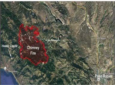
The Healthy Forests Restoration Act of 2003 defines the term “Wildland-Urban Interface” to mean:
An area within or adjacent to an at-risk community that is identified in recommendations to
the Secretary in a community wildfire protection plan; or in the case of any area for which a
community wildfire protection plan is not in effect.
o An area extending ½-mile from the boundary of an at-risk community;
o An area within 1½ miles of the boundary of an at-risk community, including any land that:
▪ Has a sustained steep slope that creates the potential for wildfire behavior
endangering the at-risk community;
▪ Has a geographic feature that aids in creating an effective fire break, such as a
road or ridge top; or
▪ Is in condition class 3, as documented by the Secretary in the project-specific
environmental analysis; and
▪ An area that is adjacent to an evacuation route for an at-risk community that
the Secretary determines, in cooperation with the at-risk community, requires
hazardous fuel reduction to provide safer evacuation from the at-risk community.
The wildland fire risk associated with WUI areas includes propagation of fire throughout WUI
communities via house-to-house fire spread, landscaping-to-house fire spread, or ember intrusion.
Advantages and disadvantages associated with WUI areas include:
WUI Advantages:
WUI areas often have community water supply
systems
Many homes can be accessed by a single road
Emergency equipment can protect multiple
assets at once
Houses usually only exposed to flammable
fuels on one side
WUI Disadvantages: Figure 1. Wildland Urban Interface
High housing density; house to house fire
spread is likely
Roads can become congested during emergencies
Limited options if the community water systems fail
Wildland-Urban Intermix
Wildland-Urban Intermix areas are those where housing
and vegetation intermingle. In the Intermix, wildland
vegetation is continuous and greater than 50% of the land
area is vegetated with combustible fuels. The wildland fire
risk associated with Intermix areas includes vegetation-to-
house fire spread or ember intrusion. Advantages and
disadvantages associated with Intermix areas include:
Intermix Advantages: Figure 2. Wildland Urban Intermix
Low housing density
Less likely to have house to house fire spread
8
July 2019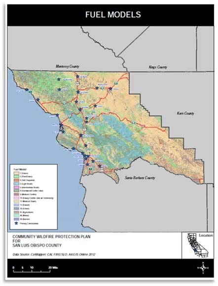
Intermix Disadvantages:
Increased risk to firefighters
Emergency equipment can only protect single assets
Emergency equipment response times can be delayed due to:
o Rural Roads (single lane, windy, heavy fuel loading)
o Long Driveways
Roads can become congested during emergencies
Diversity in water supply systems
Houses are surrounded by vegetation
Intermix areas identified within San Luis Obispo County include most rural areas of the County with
the Irish Hills/Prefumo Canyon, Poly Canyon and Reservoir Canyon areas having the most influence
on fire spread into the City of San Luis Obispo. These areas create Mutual Threat Zones with CAL
FIRE.
Population Flux
Another important factor in evaluating the
population in the City of San Luis Obispo is the
temporal shift in population density, which has
implications for firefighter or emergency
response and fire risk reduction planning.
Population fluctuations at various scales
include an influx of tourists during spring and
summer months due to large events such as
the San Luis Obispo Beer Festival, concerts at
Madonna Meadows and Cal Poly Graduation.
Increased populations result in increased
human presence in wildland areas during the
summer months for recreation purposes. In
addition to the wine tourism, open space hiking
trails and proximity to Avila Beach draw
thousands, of visitors each year. Consideration
of these temporal effects is important for City of San Luis Obispo
planning strategic fuel treatment projects
intended to protect communities or resources,
allocating emergency response personnel, and
reducing potential ignition sources.
FIRE ENVIRONMENT
The fire environment is defined as the “surrounding conditions, influences, and modifying forces that
determine fire behavior”. The four components that affect fire behavior are fuels, weather, topography,
and human behavior. Understanding the relationship between these factors and their influence on fire
behavior must be considered to plan the most effective strategies for reducing the threat of unwanted
fire.
9
July 2019Of the factors listed above, fuels (vegetation, buildings, etc.) are the component that is targeted most
often since this factor is the most easily affected. For example, vegetation can be removed or
manipulated in ways that will dramatically reduce the fire risk. Homes can be “hardened”, i.e. built with
non-combustible or fire-resistant materials as defined in the California Wildland-Urban Interface Code
(W.U.I.) Chapter 7A. Along, with property maintained with adequate defensible space and proper
property hygiene as enforced by the Hazardous Fuels Reduction Program.
While the weather cannot be controlled, it is important to understand what types of weather can occur
that increase the fire hazard and what options there are for reducing this hazard. An example of this
is limiting certain activities including open burning, equipment uses, welding, or mowing when weather
conditions are hot and dry.
As with the weather and topography, the terrain cannot be significantly altered to reduce the fire
hazard. Terrain, however, has a strong influence within the fire environment and should be carefully
assessed when designing fire hazard reduction treatments. Aspect has a strong bearing on the type
of vegetation present and the temperature and moisture regime of the soil and vegetation. Slope
steepness (gradient) is important since fire behavior usually increases with steepness. Slope position
(ridge, valley, saddle, draw, etc.) should be considered when planning fire prevention measures. For
example, additional defensible space may be warranted where slopes are steep and if positioned on
a warm southerly aspect and/or within a “chimney” (draw, saddle).
“Full alignment” is a term used to describe the fire environment when all the conditions are conducive
for increased fire activity. This occurs when fires burn in heavy fuels, during hot, dry weather with
strong winds blowing up steep slopes and draws. Highest priority for fire prevention measures should
be focused on areas where these types of conditions are known to occur or are considered likely.
Additional discussion on fuels, weather, and topography is below.
VEGETATION / FUELS
Due to the County’s varied climate and geography, there is a diverse population of plants. In fact, the Central
Coast Bioregion is considered one of the most biologically diverse areas in North America and many species
are found nowhere else in the world. Plants are categorized as native (naturally occurring prior to European
settlement), (endemic) or non-native (introduced) which have been transported into San Luis Obispo County
from other regions or ecosystems. All plants and vegetation types have a range of environmental conditions
within which they can grow known as “limits of tolerance”. For plants, the limiting factors that determine the
range of a species or plant community are precipitation, temperature, solar radiation, soil structure,
elevation, and disturbance regime.
The California Wildlife Habitat Relationships System (CWHR) provides a classification system of existing
vegetation types important to wildlife. The CWHR system was developed to recognize and categorize major
vegetation types in California at a scale sufficient to predict wildlife-habitat relationships. Table 3 presents
the vegetation types identified for San Luis Obispo County and includes acreages and percentage cover for
the County.
10
July 2019Vegetation (or fuel) plays a major role in fire behavior
and shaping fire hazard potential. Vegetation Table 3. Vegetation Types in San Luis Obispo County
distribution throughout the County varies by location Approximate
and topography, with dramatic differences observed Vegetation Type* Percentage
Acreage
between the eastern, agricultural and ranching Agriculture 120,908 5.69%
portions of the County, and the more mountainous
Alkali Desert Scrub 32,415 1.53%
central and southern regions. Current land cover
Annual Grassland 991,331 46.66%
distribution within the County is characterized by 32
Barren 6,160 0.29%
different vegetation types which have been classified
Blue Oak Woodland 185,966 8.75%
into 14 different fuel models (Figure 4), as presented
Blue Oak‐Foothill Pine 36,302 1.71%
in Table 4. The most abundant vegetative cover within
San Luis Obispo County is herbaceous (46.9%), or Chamise‐Redshank Chaparral 130,021 6.12%
annual grassland, distributed primarily in the inland Closed‐Cone Pine‐Cypress 3,121 0.15%
valley and plain areas east of the La Panza, Garcia, Coastal Oak Woodland 188,229 8.86%
and Santa Lucia Ranges. While this fuel type can burn Coastal Scrub 88,528 4.17%
quickly under strong, dry wind patterns, it does not Desert Scrub 670 0.03%
produce the high heat intensity and high flame lengths Desert Succulent Shrub 245 0.01%
associated with scrub, chaparral, and forest fuel Desert Wash 469 0.02%
types. Other significant vegetative cover types include Eucalyptus 10 0.00%
light brush (16.5%), pine/grass (12.1%), and Freshwater Emergent Wetland 25 0.00%
hardwood/conifer litter (8.3%). These vegetation Juniper 5,538 0.26%
types are primarily associated with the steeper, Lacustrine 59 0.00%
upland areas in the La Panza, Garcia, and Santa
Mixed Chaparral 158,147 7.44%
Lucia Ranges throughout the central portion of the
Montane Hardwood 28,521 1.34%
County. Fire behavior in brush fuel types produces
Montane Hardwood‐Conifer 12,528 0.59%
higher flame lengths than that in grassland, although
Montane Riparian 252 0.01%
spread rates are typically slower. Fire behavior in
Pinyon‐Juniper 5 0.00%
forests is variable, depending on surface fuel
conditions and the presence of ladder fuels. Ponderosa Pine 684 0.03%
Sagebrush 4,747 0.22%
Variations in vegetative cover type and species Saline Emergent Wetland 294 0.01%
composition have a direct effect on fire behavior. Unknown Conifer Type 1,240 0.06%
Some vegetation types and their associated plant Unknown Shrub Type 44,753 2.11%
species have increased flammability based on plant Urban 53,659 2.53%
physiology (resin content), biological function Valley Foothill Riparian 3,264 0.15%
(flowering, retention of dead plant material), physical Valley Oak Woodland 11,120 0.52%
structure (leaf size, branching patterns), and overall Water 15,170 0.71%
fuel loading. For example, the native shrub species Wet Meadow 17 0.00%
that compose chaparral vegetation types present a *Source: FRA
high potential hazard based on such criteria.
As described, vegetation plays a significant role in fire behavior. A critical factor to consider is the dynamic
nature of vegetation types. Fire presence and absence at varying cycles or regimes affects vegetation
type succession. Succession of vegetation types, most notably the gradual conversion of shrublands
to grasslands with high fire frequency and grasslands to shrub lands with fire exclusion, is highly
dependent on fire regime. Biomass and associated fuel loading will increase over time, if disturbance
or fuel reduction efforts are not implemented.
11
July 2019Table 4: Fuel Model Types in San Luis Obispo County
Wildfire disturbances can also have Fuel Model Approximate Percent
dramatic impacts on plants and plant Description
Number* Acreage Cover
composition. Heat shock, accumulation
1 Grass 997,984 46.98%
of post-fire charred wood, and change in
photoperiods due to removal of shrub 2 Pine/Grass 256,610 12.08%
canopies may all stimulate seed 4 Tall Chaparral 88,290 4.16%
germination. The post-fire response for 5 Light Brush 349,780 16.46%
most species is vegetative reproduction 6 Intermediate Brush 3,103 0.15%
and stimulation of flowering and fruiting. 8 Hardwood/Conifer Litter 176,008 8.29%
The combustion of above ground
9 Medium Conifer 242 0.01%
biomass alters seedbeds and
10 Heavy Conifer Litter w/ Understory 9,630 0.45%
temporarily eliminates competition for
moisture, nutrients, heat, and light. 12 Medium Slash 228 0.01%
Species that can rapidly take advantage 15 Desert 545 0.03%
of the available resources will flourish. It 28 Urban 19,687 0.93%
is possible to alter successional 97 Agriculture 220,097 10.36%
pathways for different vegetation types 98 Water 1,726 0.08%
through manual alteration. This concept
99 Barren 458 0.02%
is a key component in the overall
*Source: FRAP
establishment and maintenance of fuel
reduction projects.
Figure 3: Fuels Distribution Figure 4: Fuel Model
12
July 2019TREE MORTALITY
Sudden Oak Death
The moist climate in the Central Coast Region supports the Sudden
Oak Death (SOD) pathogen. Sudden Oak Death is currently found
at the Monterey/San Luis Obispo County border, though the potential
for spread into San Luis Obispo County is high. The SOD Map is a
useful application that produces a Google Earth.kmz file for viewing
SOD locations and sample sites. SOD has the potential to kill a
significant number of coast live oak, California black oaks, Shreve
oak, canyon live oaks and tanoaks in the County. This poses a potentially significant increase in the fire
hazard within infected areas due to the increase in the amount of dead fuel available. The loss of tree
canopy will, increase ground fuels by the, regenerating shrub species, which in turn increases the fire
hazard. Aerial monitoring, stream side monitoring and ground checking dying oak trees are conducted
annually by agencies and universities to monitor the spread of the disease, and research is being conducted
to determine potential abatement methods.
The short-term and long-term implication of these forest diseases and other insect infestations in relation
to fire prevention and protection is the relatively rapid mortality that occurs, resulting in increased dead fuel
loads. The recently dead standing fuels contribute to increased wildfire incidence and severity and require
treatment and/or removal, especially within WUI areas. Furthermore, care must be taken to avoid
transportation of infested material or spreading these diseases by using or transporting infected tools,
chips, and trimmings/plant material into non-infected regions.
13
July 2019WEATHER
San Luis Obispo is characterized by a Mediterranean climate with most annual rainfall occurring during the
winter and early spring. However, the primary climate is defined by long, warm, dry summers and brief,
cool sometimes rainy winters. The City receives an annual rainfall of about 19.02 inches per year and
typically, no rain fall from May through September. Summers in San Luis Obispo tend to be very warm,
with daily temperatures frequently exceeding 80 degrees from late June to as late as mid-September, and
occasionally exceeding 90 degrees. Summers in San Luis Obispo experience an unusually large daytime-
nighttime temperature swing, where there may be profound temperature difference, as much as 40
degrees, between the daytime and nighttime temperature.
Terrain contributes significantly to the weather in San Luis
Obispo. San Luis Obispo is positioned on the Western side of
the Santa Lucia Mountain Range and the Eastern side of the
California Coast Range (Irish Hills). The Santa Lucia Range
intercepts a large portion of the rain bearing clouds moving
eastward from the Pacific Ocean. These ranges also separate
the cooler, moister marine-influenced areas from the arid inland
area during much of the summer. The entire area east of the
range can be described as arid, with San Luis Obispo often
receiving less than 20 inches of rain annually. Another locally
important characteristic affecting weather is the frequency of
summer fog. Fog conditions augment rainfall and provide
moisture for plant growth and affect live and dead fuel
moistures. However, the summer fog typically burns off by 10:00
a.m.
San Luis Obispo County is broken into two weather zones, Coastal and Inland. San Luis Obispo is in
the Coastal Zone. Using weather factors such as wind, humidity, and temperature, the two zones are
ranked by their frequency of severe fire weather. These areas are ranked as moderate (severe fire
weather occurring fewer than 26 days per year), high (severe fire weather occurring between 26 and 46
days per year), and very high (severe fire weather occurring more than 46 days per year). Some areas
ranked as ‘very high’ can experience severe fire weather up to 88 days per year. Although weather
conditions can reduce the number of days that a devastating fire can occur, all areas of the County
regularly are subject to days or “windows” when severe burning conditions exist.
The California National Fuel Moisture Database (NFMD) is a web-based query system that enables users
to view sampled and measured live and dead-fuel moisture information. The database is routinely
updated by fuels specialists who monitor, sample, and calculate live fuel moisture data.
Remote Automated Weather Stations
A system of Remote Automated Weather Stations (RAWS) is used to acquire
site specific weather data. The RAWS are self-contained weather stations which
sample weather on a periodic basis and then transfer this information via satellite
to a federal server. This weather data can then be used for emergency responses
and project planning. There are currently six stations located within San Luis
Obispo County. Four of these stations are owned and maintained by CAL FIRE
and two are owned and maintained by the U.S. Forest Service. These stations
have been placed to measure weather in certain areas in the County. The Arroyo
Grande RAWS reporting station is the most proximate to the City of San Luis
Obispo. Station information and real-time weather data such as the current
weather summary for the Los Angeles/Oxnard CWA is available from MesoWest.
14
July 2019Figure 5: RAWS
15
July 2019TOPOGRAPHY
Topography is essentially the lay of the land and is commonly characterized by measurements of slope,
elevation, and aspect. The topography (Figure 6) of San Luis Obispo is variable and greatly affected by the
Santa Lucia Coastal Range. The topography of the area consists of gentle rolling hills on the eastern half
of the city, and foothill peaks which rise in elevation to the west, which are blanketed in the California
chaparral environment. San Luis Obispo sits on the western foothills of the Santa Lucia Coastal Mountain
Range, which lies directly to the East of the city, and runs in North-South direction. The city is located at
the Eastern side of the California Coast Range (Irish Hills) and is centered between the Morros (Bishop
Peak and Cerro San Luis).
Elevation affects temperature, humidity, wind speed,
and the growing season of vegetation. Aspect affects
the amount of solar radiation absorbed by plants.
Southern aspects normally receive maximum solar
radiation while northern aspects receive the least.
Soil and plant moisture contents are the primary
factor influenced by solar radiation. As southern
aspects receive the most solar radiation, plants on
south facing slopes tend to be more drought tolerant
than those adapted to northern aspects. Slope is the
steepness of the land, calculated as the product of
the change in elevation (rise) divided by the
horizontal distance covered (run). Slope is typically
presented in units of percent or degrees. Steeper
slopes can have a significant effect on fire behavior
as a fire moving uphill can preheat and dry vegetation
uphill from it and accelerate the rate of fire spread.
The topographic conditions can have considerable
effect on wildland fire behavior, as well as on the
ability of firefighters to suppress those fires. Steep
slopes and canyon alignments are conducive to
channeling, deflecting, concentrating, or dispersing
winds, and creating extremely erratic wildfire
conditions, especially during wind-driven fire events.
16
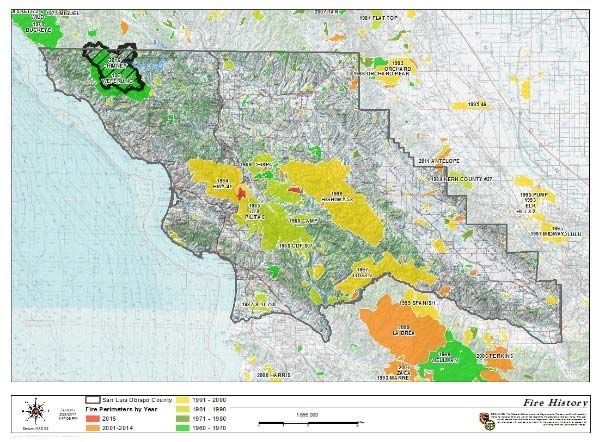
July 2019FIRE HISTORY
Fire history is an important component in understanding fire frequency, fire type, significant ignition sources,
and vulnerable areas/communities. The topography, vegetation, and climatic conditions associated with San
Luis Obispo County combine to create a unique situation capable of supporting wildfires. Many large,
damaging wildfires have occurred in the County, notably the Chimney Fire (2016), the Weferling Fire (1960),
the Las Pilitas Fire (1985), the Chispa Fire (1989), the Highway 41 (1994), the Highway 58 Fire (1996), and
the Logan Fire (1997). The fires burned approximately 400,000 acres, destroyed numerous structures, and
cost millions of dollars to suppress. The fire with the most recent significant impact on the County was the
Chimney Fire west of the City of Paso Robles, which destroyed 49 residences and 21 other structures. While
these large fires can create significant damages due to their size, even smaller WUI fires in densely
developed areas can be very damaging.
Based on historical fire perimeter data, repeated burning is
observed within the County primarily in the Santa Lucia
Range. Land ownership (federal) and fuel type (chaparral)
appear to be significant factors affecting the geographic
distribution of fires in San Luis Obispo County. Grass-
dominated lands in the eastern portion of the County exhibit
small, well dispersed burn perimeters, while the heavier
chaparral fuels in the central-southern portion of the County
(Santa Lucia Range) exhibit a repeated burn pattern, larger
fire perimeters, and a more concentrated distribution of fire
perimeters. The average interval between large wildfires
more than 20,000 acres burning within San Luis Obispo
County is 7.3 years, with intervals as short as 1 year and as
long as 17 years.
Large Fire History in San Luis Obispo County
17
July 2019IGNITION HISTORY
State Responsibility Area
Ignition Cause* Number Percentage
(SRA) Ignition data for San
Luis Obispo County was Arson 31 4%
analyzed for a 5-year period Campfire 35 4%
(2013-2017) to evaluate
Debris Burning 46 6%
ignition trends and problems
within the County. This Powerline/Vehicle/Equipment Use 319 41%
dataset includes 781 Lightning 10 1%
ignitions and includes an
Playing w/ Fire 7 1%
identification of fire cause.
Table 6 and Figure 8 Unknown/Undetermined 326 42%
present the ignition history Smoking 9 1%
for San Luis Obispo County Table 6: SRA Ignition History for San Luis Obispo County (2013‐2017)
between 2013 and 2017,
classified by fire cause.
The 5-year ignition history for San Luis Obispo County identifies trends in ignition type, with most ignition
causes classified as Miscellaneous or Undetermined. Vehicle, Equipment use, and Electrical also
emerge as significant ignition sources in the County. Spatial analysis of ignition locations reveals a
direct correlation between ignitions and roads/transportation corridors. Specifically, of the 781 ignition
points containing a latitude and longitude included in the dataset, approximately 48% are located within
20 feet of any road. Of these 48%, nearly 29% occur within 20 feet of Highways in the county.
High density of ignitions is also observable within and adjacent to urban areas, with notable
concentrations observed near the communities of Cambria, Lake Nacimiento, Paso Robles, Templeton,
Atascadero, Los Osos, San Luis Obispo, Arroyo Grande, and in the Nipomo area. This concentration
of ignitions in urban areas and along transportation corridors emphasizes the importance of public
education and fire prevention activities, including road-side fuel treatments and strategic management
of flashy fuels (e.g. grasses) in WUI and Wildland Urban Intermix areas.
Figure 8: Ignition Density
18
July 2019PREPAREDNESS AND FIREFIGHTING CAPABILITIES
San Luis Obispo County fire agencies put tremendous effort into maintaining the highest preparedness
level possible. This is a priority for each agency and program. Each agency works with the intent to
accomplish the mission of public protection and fire safe community. The fire administration and fire
prevention divisions are fulltime functions that assist the fire operations division before, during and after
an emergency event takes place. Additionally, San Luis Obispo county agencies present annual
preparation events to assist in maintaining the goal of keeping wildland fires at 10 acres or less. Below
is a brief outline of the preparation efforts of each division within the San Luis Obispo City Fire
Department:
Fire Administration Division
Among the many tasks that revolve around managing department policies, budgets and
logistics, Administrative staff also determines and implements staffing levels to achieve the
agency’s mission. Additionally, administrative staff prepare and maintain cooperative fire
service agreements and resource response plans, like the SLU Auto-Aid Agreement and the
San Luis Obispo County Mutual Aid plans. These plans provide operations the preparedness,
fire resources and depth necessary for mission success.
Fire Operations Division
The operations division provides a professional level of service related to fire control and
suppression, rescue, advanced life support/emergency medical assistance, and the mitigation
of hazardous materials incidents. In the event of major disasters, they are trained and equipped
to handle a citywide incident, including wildland and structural fires, earthquakes, riots,
hazardous material incidents, nuclear events, and other major emergencies. In addition to
responding to emergency, training, fleet management, and dispatch, operations serve a critical
role to our efficiency and preparedness to respond.
Fire Prevention Bureau
Prevention staff spends much of their time supporting field mission preparedness and
preventing fires. It is divided into four areas; law enforcement & education; planning &
engineering; pre-fire planning, and resource management. Each function may be full, or part
time staffed (depending on the agency’s resources) and collectively work to support the efforts
of operations. Prevention preparation activities include defensible space and the Ready-Set-Go
program, emergency evacuation planning, fire prevention education, incident intelligence and
mapping, implementation of the State Fire Code, and fire-related activities such as fire
investigation. Other common projects include identifying fire break construction and fire fuel
reduction activities that lessen the risk of wildfire to communities and evacuation routes.
19
July 2019Firefighting Capabilities
The fire service in San Luis Obispo (SLO) County is comprised of a cohesive and cooperative
group of 17 agencies. Services are provided by a combination of city, special district, county,
state, federal, and private agencies that operate 48 fire stations. These fire agencies have also
developed an automatic mutual aid program that provides for the closest fire engine to respond
to a new emergency regardless of the jurisdiction. This cooperative fire protection system gives
each agency a depth and weight of response to be successful in mitigating both large scale and
simultaneous emergency events within the County.
20
July 2019SECTION II: COLLABORATION
COMMUNITY / AGENCIES / FIRE SAFE COUNCILS / FIREWISE COMMUNITIES
As a key component of the Healthy Forest Restoration Act (HFRA) of 2003, a Community Wildfire
Protection Plan (CWPP) serves as a mechanism for community input and identification of areas
presenting high fire risk as well as identification of fire hazards and potential projects intended to mitigate
such risk. This Plan integrates the community-focused approach of the CWPP process and is intended
to provide the community a forum for identifying assets and communities at risk from wildfire, which may
include people, property, natural resources, cultural values, economic interests, and infrastructure. The
identification of these assets or communities by the community strongly influences the potential wildfire
hazard mitigation projects identified in this Plan. The organization and title of representatives involved in
the development of this Plan are indicated below.
Plan Development Team:
Organization Title
CAL FIRE / San Luis Obispo County
Fire Chief
Fire
Cambria CSD Fire Department Fire Chief
City of Atascadero Fire Department Fire Chief
City of Paso Robles Fire Department Fire Chief
City of Morro Bay Fire Department Fire Chief
City of San Luis Obispo Fire Fire Chief
Department
Five Cities Fire Authority Fire Chief
Los Padres National Forest Forest Supervisor
Bureau of Land Management Forest Supervisor
San Luis Obispo County Community
President
Fire Safe Council
San Luis Obispo County Fire Chiefs
President
Association
21
July 2019COMMUNITY / AGENCIES / FIRE SAFE COUNCILS / FIREWISE COMMUNITIES
The location and size of San Luis Obispo County dictate that local fire resources must be used effectively
since these resources are limited, and additional resources could be several hours away. The diversity of
available resources and fire-related problems mandate the cooperative use of fire service resources.
Cooperative assistance is provided on reciprocal contributions without charge and may be provided in two
forms:
Automatic Aid: a predetermined immediate joint response to provide effective fire protection
Mutual Aid: responses to supplement the resources of any fire agency during a period of actual or
potential need, including move-up and over assignments.
Mutual Aid is dependent on recognition that equipment and resources are expected to be provided only
when dispatch of the resources will not unduly jeopardize local capabilities.
This San Luis Obispo County Fire Services Mutual Aid Plan intends to provide the following:
Upon demand, provide the cost-effective use of the emergency resources of all jurisdictions
Achieve a balance over the long run between providing and receiving entities
Eliminate complex financial and legal agreements
Address all mutual aid responses and station coverage assignments required of the fire service,
including but not limited to the following:
o Fire o Earthquake
o Rescue o Natural and Human-caused Disasters
o Hazardous Materials o EMS/Mass Casualty Incidents
The following fire departments, districts, and agencies currently engage in Automatic/Mutual Aid
agreements in San Luis Obispo County:
Atascadero Fire Department Morro Bay Fire Department
Atascadero State Hospital Fire
Department
Pismo Beach Fire Department
Avila Beach Fire Department
Santa Barbara County Fire Department
CAL FIRE San Luis Obispo
South Bay Fire Protection District
Camp Roberts Fire Department
San Luis Obispo County Fire
CAL FIRE-San Benito-Monterey
San Luis Obispo City Fire Department
Cambria Fire Protection District
San Miguel Fire Protection District
California Men's Colony
Santa Maria Fire Department
CAL FIRE Fresno-Kings
Santa Margarita Fire Protection District
Five Cities Fire Authority
Templeton Fire Protection District
Guadalupe Fire Protection District
U.S. Forest Service (Los Padres
Hearst Castle Fire Department National Forest)
In addition to the Automatic/Mutual Aid agreements identified above, dispatch agreements also exist
between CAL FIRE/SLO, Cambria Community Services District, the Santa Margarita Fire Protection
District, the San Miguel Community Services District, the Templeton Community Services District, the City
of Morro Bay, the Five Cities Fire Authority, and the CNG-Camp Roberts.
22
July 2019The California Master Cooperative Wildland Fire Management and Stafford Act Response Agreement
(CFMA) requires an Annual Operating Plan to coordinate wildfire response efforts between State and
Federal Agencies. For San Luis Obispo County, the Central Coast Operating Plan (CCOP) represents
an agreement between CAL FIRE, BLM, USFS, and the U.S. Fish and Wildlife Service (USFWS) and
provides the participating agencies with the guidelines and information necessary to properly execute
the terms of the Agreement. The CCOP identifies fire protection elements, special management
considerations, fire protection organization, maps, operational procedures, fire prevention activities,
general procedures, and a list of relevant agency contacts.
23
July 2019SECTION III: VALUES
VALUES
CAL FIRE’s Fire and Resource Assessment Program (FRAP) prepared the document entitled California’s
Forest and Rangelands: 2015 Assessment. This document satisfies the 2008 Federal Farm Bill provision
that each state assesses forest resources, which is intended to identify key issues facing each state and
requires the delineation of spatial areas called Priority Landscapes. Priority Landscapes are intended to
focus investments and other programs to address issues identified in the assessment. Priority Landscape
datasets related to fire include an evaluation of fire risk as related to community water, ecosystem health,
forest economics, human infrastructure, range economics, recreation and open space, and wildlife.
The fire/human infrastructure Priority Landscape developed by FRAP represents the convergence of areas
with high wildfire threat and human infrastructure assets. Included in this assessment are communities and
assets. Community areas include incorporated city boundaries and Census Designated Places for
unincorporated communities while assets include residential and commercial structures, major roads, and
transmission lines. Wildfire threat is the result of an analysis of fire frequency (likelihood of a given area
burning) and potential fire behavior (fire hazard). For purposes of illustration, below are three examples,
Fire Threat to Ecosystem Health, Rangeland Fire Threat, and Post Fire Erosion Threat to Community Water.
Figure 9: Rangeland Fire Threat Figure 10: Ecosystem Threat Figure 11: Post Fire Erosion Threat
Another dominant factor affecting wildfire risk is the prevailing wind pattern in San Luis Obispo County.
Specifically, on-shore winds from the northwest routinely pick up in the late morning hours increasing the
risk of pushing a fire in a southeast direction if not extinguished by late-morning (approximately 10 am).
This condition is observable in the shape of large fire burn perimeters in San Luis Obispo County. For
example, prevailing winds contributed significantly to the extent of the 1994 Highway 41 Fire, which
originated northwest of the City of San Luis Obispo and burned southwest toward the City of San Luis
Obispo and northeast toward the City of Atascadero.
While no large fires are included in the fire history dataset for the Irish Hills and Reservoir Canyon area of
San Luis Obispo, the potential fire risk in this area is considered medium to high. Similar conditions exist
with heavy fuels, prevailing wind patterns and steep terrain throughout the interface surrounding the City.
24
July 2019FIRE RISK vs. FIRE HAZARD
The concept of fire risk vs. fire hazard can be confusing and these terms are often used interchangeably.
The purpose of this Plan is to assist fire agencies with development of collaborative methods of reducing
the fire ‘risk’ within their jurisdictions by using strategies and tactics that will reduce or eliminate one or more
fire ‘hazards’. Examples of fire hazards include dense stands of decadent brush, faulty wiring, broken
vehicle exhaust systems, and homes that are not built in accordance with fire code requirements. The fire
risk (vulnerability) of a given area constantly rises and falls depending on conditions within the fire
environment. Successful implementation of this Plan will result in the meaningful reduction of the fire risk
in strategic portions of the County through identification and abatement of important fire hazards.
PRIORITY COMMUNITIES
To evaluate Priority Communities in the State, FRAP analyzed the fire/human infrastructure Priority
Landscape dataset in combination with communities that include at least 500 people or 1,000 acres.
Communities ranked as medium or high Priority Landscapes (for fire/human infrastructure) constitute
Priority Communities. The intent of the Priority Community identification is to provide a way of identifying
possible communities for outreach and further strategy development. The Priority Communities dataset was
utilized as a starting point for identifying and prioritizing communities in San Luis Obispo County where
efforts can be focused to reduce wildfire threat. This dataset was refined based on input from community
stakeholders and based on an assessment of fire history, ignition history, land ownership, vegetation/fuel,
or terrain.
Priority Communities for San Luis Obispo County are identified in Table 7. Priority Communities are those
in which pre-fire management activities, including hazardous fuel reduction and public education, should be
focused. This list of communities is based on available fire hazard planning data from FRAP, augmented
with a County-scale analysis of fire hazard variables and input from community stakeholders and should be
routinely evaluated and updated, as needed.
Table 7: Priority Communities in San Luis Obispo County
Community* Planning Area
Adelaida SLU-1.3
Arroyo Grande SLU-1.2
Atascadero SLU-1.4
Avila Beach SLU-1.6
Baywood Park-Los Osos SLU-1.1
Cambria SLU-1.1, CMB-1
Cayucos SLU-1.1
Lake Nacimiento SLU-1.3
Nipomo SLU-1.2
Paso Robles SLU-1.3, PRF-1
Pismo Beach SLU-1.6
San Luis Obispo SLU-1.1, SLO-1
San Miguel SLU-1.5, SMG-1
Santa Margarita SLU-1.4, SMV-1
Templeton SLU-1.3, TEM-1
*Source: FRAP
25
July 2019PLANNING AREAS
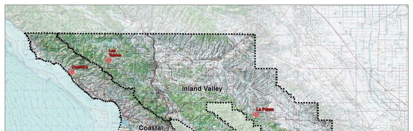
For the purposes of this Plan, San Luis Obispo County has been divided into multiple Planning Areas to
facilitate localized pre-fire planning efforts. The following provides a brief description of each Planning
Area affecting the City of San Luis Obispo.
San Luis Obispo Planning Area (SLO-1)
The San Luis Obispo Planning Area encompasses the City of San Luis Obispo and is approximately
8,404 acres in size. The San Luis Obispo City Fire Department is the Fire Authority Having Jurisdiction
(FAHJ) for this Planning Area and San Luis Obispo is a Priority Community designated in this Plan. Fire
history according to the historical database (FRAP) in this Planning Area includes the 1985 Las Pilitas
Fire, which burned the eastern portion of the City and the 1994 Highway 41 Fire which burned within
approximately 400 feet of the eastern boundary of the City.
SLU Planning Area 1 (CAL FIRE – Battalion 1; SLU-1.1)
SLU Planning Area 1 encompasses approximately 300,963 acres and is situated along the Pacific Ocean
from the Monterey County Boundary in the north to approximately Point Buchon in the south. Its eastern
boundary runs along the ridge of the Santa Lucia Range and extends eastward to the City limits of
Atascadero and southward to the boundary of the City of San Luis Obispo. The City of Morro Bay and the
communities of San Simeon, Cambria, and Cayucos are located along the Pacific Ocean in the western
portion of the Planning Area. Planning Area 1 includes the Priority Community of Baywood Park-Los Osos
South Bay SBY Planning Area -1). Large fire history in the Planning Area includes the 1960 Weferling Fire
and the 1994 Highway 41 Fire, and the 2016 Chimney Fire.
SLU Planning Area 2 (CAL FIRE – Battalion 2; SLU-1.2)
SLU Planning Area 2 encompasses approximately 447,903 acres and is situated along the southern
boundary of the County, adjacent the Cuyama River. Planning Area 2 stretches the entire length of the
County, from Kern County in the east to the Pacific Ocean in the west and is bisected by the Los Padres
National Forest (LPF) in the central portion of the Planning Area. Its northern boundary runs along the
boundary of the LPF, adjacent the ridge of the Garcia and Caliente Ranges and extends northward to the
City limits of San Luis Obispo. Planning Area 2 includes the Priority Community of Nipomo. Large fire
history in the Planning Area includes the 1985 Las Pilitas Fire and the 1997 Logan Fire.
26
July 2019CRITICAL INFRASTRUCTURE/CULTURAL/BIOTIC ASSETS
For the purposes of this Plan, critical infrastructure/cultural/biotic assets are those values that may
be at risk from wildfire. Assets in San Luis Obispo include among others power transmission
facilities, emergency communication facilities, transportation infrastructure, tourist and recreation
areas. Table 8 presents the assets in the San Luis Obispo Planning Area.
Table 8: Assets in the San Luis Obispo Planning Area
Asset
Trains/Rail System
Transportation Corridors (Highways 101, 1 and 227)
Communication Sites/Systems
PG&E High Tension Power Lines
State Water Project
Electrical and Communication Transmission and
Power Substations
Cultural and Historical Icons
Schools and Public Facilities
Gas Lines
Critical Watersheds
San Luis County Airport
Los Padres NF Botanical Gardens
Bishop Peak Recreational Site
San Luis Mountain Recreational Site
Whale Rock Reservoir
El Chorro Regional Park
Camp San Luis Obispo (California National Guard)
27
July 2019COMMUNITIES
Communities at Risk (CAR) from potential wildfire were identified at the federal level in the 2001 National
Fire Plan (66 Fed. Reg. 753, January 4, 2001), which included only communities that were near federal
lands. Recognizing that wildfire risk was not limited to areas near federal lands, CAL FIRE developed a
more inclusive list of communities at risk for the State of California, which is managed by the California Fire
Alliance. The communities identified in the San Luis Obispo County CWPP were derived from the
Geographic Names Information System (GNIS) database and evaluated to ensure that all Communities at
Risk were accounted for. The GNIS database of communities in the County was then consolidated to
represent major communities in the County and historical places were excluded.
The City of San Luis Obispo was identified as a Community at Risk (CAR).
28
July 2019SECTION IV: TACTICAL POLICY MATRICES
EDUCATION
The goal of the Education section is to prepare response organizations, communities, the public, and
policy makers regarding appropriate community actions and interactions to reduce the unwanted impacts
of fires in the wildland urban interface
Strategic Policy Benefits of the Project to the Community Category Timeline ID
SLO County Strategic Goal ED1: Educate citizens of how to achieve contemporary WUI (wildland-urban
interface) code compliance in retrofits/cost: benefit ratio.
Educate citizens of
how to achieve
Gives Residents detailed and locally specific tools
contemporary WUI
that they can use to improve preparedness.
(wildland Urban
Mitigates against potential fire impact in the EDU 2 Years ED1.1SLO
Interface) code
community.
compliance in
retrofits/cost: Reduces potentially wasteful spending.
benefit ratio.
Provide SLO Ready
Set Go guide and Gives Residents detailed and locally specific tools
host 2 to 3 RSG that they can use to improve preparedness.
events as part of Mitigates against potential fire impact in the EDU 1 Year ED1.2SLO
“Prepare SLO” community.
program
SLO County Strategic Goal ED2: Organize a community group made up of residents and agency personnel
to develop materials and communicate relevant defensible space messages.
Emergency
preparedness
meetings. Use
preparedness
experts. Host and Gives residents detailed and locally specific tools
attend community that they can use to improve preparedness. Semi-
forums/functions Mitigates against potential fire impacts in the EDU ED2.1SLO
Annually
and hold meetings community.
to provide
guidance for
creating household
emergency plans.
Identify focus groups
to receive Ready Set
Go presentations: Gives residents detailed and locally specific tools
- Irish Hills that they can use to improve preparedness.
- Bishop Peak Mitigates against potential fire impacts in the EDU 2 Years ED2.2SLO
- East Madonna community.
- South Hills
- Johnson Area
29
July 2019You can also read