Nome Tribal Climate Adaptation Plan - Nunamquq aiqturaq nuit aiqturuat ilagiksruaq mumiqtuk - Alaska Center for ...
←
→
Page content transcription
If your browser does not render page correctly, please read the page content below
Nome Tribal Climate
     Adaptation Plan
     Nunamquq -aiqturaq #nuit -aiqturuat -ilagiksruaq mumiqtuk

     Healthy ecosystems, healthy people
     in a changing climate

     SEPTEMBER 2017

Kettle, N., J. Martin, and M. Sloan. 2017. Nome Tribal Climate   Kawerak Subsistence Program

Center for Climate Assessment and Policy. Fairbanks, AK.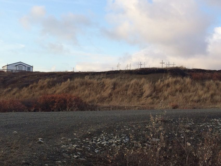
Acknowledgements
The Nome Eskimo Community received funding for this project through a grant from The Bureau of
Indian Affairs Tribal Cooperative Landscape Conservation Program Adaptation and Coastal Management
Funding (Award #A14AV00209). The project was designed as a collaborative effort among the Nome
Eskimo Community, the University of Alaska Fairbanks, and Alaska Center for Climate Assessment and
Policy (ACCAP) of the University of Alaska Fairbanks (NOAA Award #NA11OAR4310141). The
project received significant guidance and input from a local steering committee, tribal members, and
several volunteers. We would like to thank the following individuals for their support of this project.

Steering Committee Members
       Austin Ahmasuk      Kawerak
       David Evans         Sitnasuak Native Corporation
       Rose Fosdick        Kawerak
       Susan Gray          Native Village of Council
       John Pullock        King Island
       Mike Orr            Sitnasuak Native Corporation
       Emma Pate           Nome Eskimo Community
       Larry Pederson      Bering Straits Native Corporation, Council Native Corporation
       Deilah Johnson      Village of Solomon
       Kirsten Timbers     Nome Eskimo Community
       Elizabeth Johnson   Solomon Native Corporation

Nome Eskimo Community (NEC)
      Jacob Martin       Tribal Resource Director and Climate Change Coordinator
      Mike Sloan         Tribal Resource Director (Former)

University of Alaska Fairbanks, Alaska Center for Climate Assessment and Policy (ACCAP)
       Nathan Kettle         Research Assistant Professor
       John Walsh            Professor
       Sarah Trainor         Associate Professor
       Josie Sam             Program Scientist
       Stefan Tangen         Graduate Assistant

Alaska Sea Grant
       Davin Holen             Marine Advisory Program Agent, Coastal Community Resilience Specialist

We also thank the UAF Northwest campus and Kawerak for hosting our workshops and XYZ
Transportation for providing transport for Elders to attend meetings. Annie Conger and Josie Bourdon
provided the Iñupiaq translation for the vision statement on the front cover.

This report was prepared by the Nome Eskimo Community and The Alaska Center for Climate
Assessment and Policy. This report was prepared for the Native Village of Council, Nome Eskimo
Community, King Island Native Community, and Village of Solomon.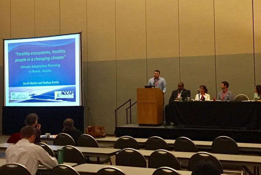
Executive Summary
The Nome Eskimo Community (NEC), in collaboration with the Alaska Center for Climate
Assessment and Policy (ACCAP), developed a climate adaptation plan with the Nome-based
tribes. This includes tribal members of NEC, Village of Solomon, Native Village of Council, and
King Island Native Community. The project goals were to familiarize tribal members with
climate science and local knowledge, provide an opportunity to identify and discuss climate
impacts and adaptation strategies, develop a plan, and share information with other rural Alaska
and Native communities. This project was funded by the Bureau of Indian Affairs.

The project consisted of:
   (1) interviewing community members to scope the planning process;
   (2) facilitating four workshops in Nome to identify impacts of concern, share goals, and
       identify and prioritize adaptation actions;
   (3) developing a climate adaptation plan; and
   (4) participating in outreach activities. This process was guided by a local steering committee
       and coordinator.

Community values for the Nome-based tribes, which provided a basis for the climate adaptation
strategies, centered on maintaining cultural activities, fostering community and relationships, and
ensuring healthy people and ecosystems.

Participants discussed several climate-related environmental changes occurring in the Nome
region over the past century, including observations of increased impacts from storms, changes
in sea ice, less snow and more rain in the winter, more rain in the summer, shallower creeks,
permafrost thaw, and impacts to subsistence activities, culturally sensitive sites, infrastructure,
and public health and safety. These changes pose significant risks for the Nome-based tribes. The
three primary concerns centered on impacts to public health and security (including impacts to
food security and subsistence), infrastructure, and increased shipping. Elders discussed how
some of these are occurring slowly, making it difficult for younger generations to notice the
changes.

Eight initiatives with specific actions were identified to address concerns:
• Adapt food preservation techniques for changing weather and climate conditions;
• Promote the use of traditional food preservation techniques that are less energy intensive;
• Reconnect families to subsistence activities;
• Increase awareness of near-term climate and related environmental conditions;
• Increase tribal representation in subsistence management;
• Protect tribal cemeteries from erosion;
• Support research and monitoring; and
• Build capacity for addressing concerns about increased shipping.

This plan is intended to be a living document that will be edited and updated as conditions
change.

                                                4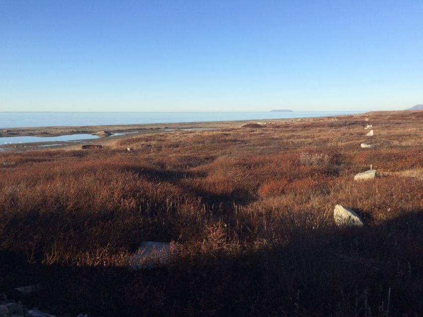
1. Introduction
    1.1 Overview of the local Alaska Native Community and Nome, Alaska
The City of Nome is located in northwest Alaska on the southern coast of the Seward Peninsula,
which is the westernmost point of the North American mainland (Figure 1). Nome lies along the
Bering Sea facing Norton Sound and is 539 air miles northwest of Anchorage and 102 miles
south of the Arctic Circle. The area encompasses 12.5 sq. miles of land and 9.1 sq. miles of
water. Nome serves as a regional and economic hub for 16 tribal villages in the region and has a
population of approximately 3600 residents (U.S. Census Bureau 2010). The gold rush around
the turn of the 20th century brought several non-Native Alaskans to Nome. Gold mining remains
the leading economic activity.

Alaska Natives, including
Central Yupik, Iñupiaq, and St.
Lawrence Island Yupik, are the
largest ethnic population group
in Nome1 (Oquilluk and Bland
1973), representing over half of
the population (ADLWD
2017). The majority of the
Alaska Native population in
Nome depends heavily on local
wild food resources such as
salmon, tomcod, crab, and seal
as an important nutritional
source in their diets. In western
Alaska the average annual
harvest of wild resources is 370      Figure 1: Study area.
pounds per person (Fall 2014).
The subsistence way of life plays an integral role in the cultural and traditional values of tribal
members living in the Nome area. Traditional knowledge is passed generationally and preserves
the cultural identity and heritage of the Alaska Native people living in Nome.

Alaska Natives in Nome are facing growing concerns regarding extreme weather and climate
impacts on wild resources important for subsistence practices (FEMA 2010). Diminishing sea
and river ice conditions threaten hunter safety as rivers and frozen ocean are important for travel
to harvest locations. Changing sea ice conditions also make increased off-shore shipping traffic
a concern (Cochran et al. 2013). Alaska Native coastal communities, such as Nome, are among
the most vulnerable to climate-related environmental impacts because they are located in remote
areas and rely heavily on the sea for their subsistence lifestyles. Despite this high risk potential
and notable climate variability and change, Alaska Native villages have generally made limited
progress on climate adaptation (GAO 2009, Markon, Trainor and Chapin 2012).

1
 For statistical purpose, these estimates also include American Indians whose lineage is tied to tribes in the Lower
48.
Since 2000, the Nome-based federally recognized tribes (Council, King Island, Solomon, Nome
Eskimo Community) and the City of Nome have engaged in many efforts to increase community
resilience to climate impacts (Table 1). There have also been workshops and trainings to discuss
the implications of climate impacts in Nome, including workshops on Promoting Coastal
Resilience and Adaptation in the Arctic (May 2016) and Bering Strait Voices Vision for Action
Summit (October 2016).
     Year    Plan
     2015    NEC Strategic Plan 2015-2020
     2015    King Island Local Economic Development Plan (LEDP)
     2012    City of Nome Comprehensive Plan
     2011    Solomon LEDP
     2010    Village of Council LEDP
     2010    King Island LEDP
     2008    City of Nome Hazards Mitigation Plan
     2007    NEC Tribal Transportation Plan
     2004    Nome Native Community Strategic Development Plan (2004-2009)
     2004    City of Nome Disaster Response Plan
     2003    City of Nome Hazard Mitigation Plan
     2003    Nome Comprehensive Plan
     2002    Nome Flood Mitigation Plan
Table 1: Sample planning documents for the Nome-based tribes and City of Nome since 2000.

Below we introduce the Nome-based tribes and the climate-related concerns identified within
their local economic development plans. For a more detailed history of each tribe and other tribes
in the Nome region, see (Kawerak 2016b). Kawerak is the regional non-profit corporation that
provides services throughout the Bering Straits Region.

    Nome Eskimo Community (NEC) represents the Alaska Native population in Nome.
    NEC’s Strategic Plan identifies addressing climate impacts to subsistence as one of its 10
    priorities (NEC 2015).

    Native Village of Council is located along the terminus of the Nome-Council Highway and
    on the banks of the Niukluk River, ~73 road miles northeast of Nome. Coastal erosion
    impacts to transportation and roads are among the greatest climate-related concerns, though
    planning is complicated as “it is not clear which agencies are responsible for planning the
    needs of the community” (Kawerak 2011a).

    Village of Solomon is located 30 miles east of Nome along the west bank of the Solomon
    River, one mile to the north of Norton Sound. Several climate-related concerns are identified
    in Solomon’s Local Economic Development Plan, including sloughing of land near the
    community graveyard, thawing permafrost under the community Bed & Breakfast, road
    damage, and the need for funding to study the long-term effects of climate change (Kawerak
    2011b).

    King Island is located ~90 miles northwest of Nome. Climate-related environmental
    concerns raised in King Island’s Local Economic Development plan include uncertainty on
    the impacts of changing resources on hunting and the need to relocate some structures at
    Cape Wooley (NW of Nome), which are in danger of erosion (Kawerak 2013).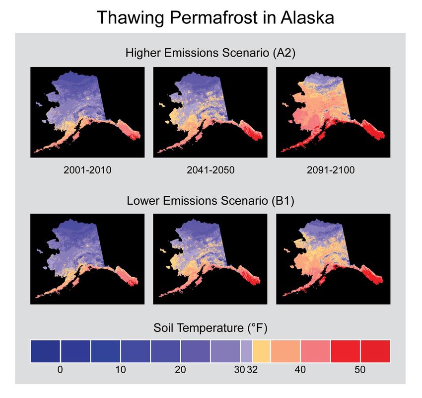
1.2 Background of climate adaptation plan
In June 2014, the Nome Eskimo Community contacted the Alaska Center for Climate
Assessment and Policy (ACCAP) to partner in the development of a tribal climate adaptation
plan for the Nome-based tribes. A Memorandum of Understanding was developed to outline the
roles and responsivities, and funding was acquired from the Bureau of Indian Affairs Tribal
Cooperative Landscape Conservation Program in 2015.

This climate adaptation plan focuses on the four Nome-based tribes. Members from each of these
tribes live in Nome year-round, rely on local wild resources, and share several climate-related
challenges.

   1.3 Developing the climate adaptation plan
The process to develop a climate adaptation plan consisted of three phases: scoping, developing
the climate adaptation plan, and outreach. Implementation of these phases were facilitated by a
local climate coordinator and a steering committee. The part-time local coordinator was a funded
position, hired by the Nome Eskimo Community.

   The local climate coordinator assisted in arranging communication among the local
   community, steering committee, and project team, and coordinated the interviews,
   workshops, and questionnaire.

   The steering committee served a key role in providing advice to the local coordinator and
   ACCAP, identifying key themes to address in the climate adaptation plan, and approving the
   final planning document. Members of the steering committee are listed on page 2.

Phase 1: Scoping. Ten tribal members from Nome were interviewed to understand observations
and experiences with climate-related environmental impacts, goals and motivations for
developing the climate adaptation plan, and additional local insights. Interviews were selected
based on recommendations from each of the four tribes and the local climate coordinator (Jacob
Martin). Interviewees represented each of the four tribes, their village corporations, Kawerak,
and Bering Straits Native Corporation. A literature review of existing tribal planning documents
and climate impacts was conducted by ACCAP.

Phase 2: Workshops. Four half-day workshops were conducted to identify impacts of concern,
share goals and visions of success, and identify and prioritize adaptation actions. Individuals not
able to attend in person were given the opportunity to provide feedback via an online survey. A
telephone connection was made available for those who could not attend in person. Tribal
participation ranged from 3 to 14 individuals for each of the meetings.

   Workshop #1: Participants were introduced to the planning process, discussed local
   observations of change, identified climate impacts of concern, and discussed community
   values and visions of success. Discussions of climate change included those by village Elders
   and climate scientists.
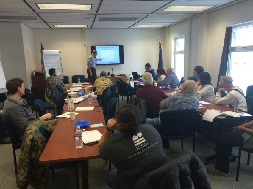
Figure 2: Discussion of local and western science observations of climate change in Nome.
(Photo credit: ACCAP)
Workshop #2-4: Participants discussed potential adaptation actions that can be taken to
address each of the key risks and vulnerabilities, including those related to food security and
subsistence (#2), coastal erosion and infrastructure (#3), and increased shipping (#4).
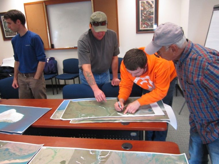
Figure 3: Tribal members and staff prioritize topics to discuss for the identification of climate adaptation
strategies (left) and locate areas experiencing coastal erosion (right). (Photo credits: ACCAP)
Questionnaire: Information from the workshops was supplemented by a web-based
questionnaire, which was distributed to NomeAnnounce – a public listserv for the region. The
questionnaire enabled participation by nine tribal members unable to attend in person.
The climate adaptation plan was drafted by ACCAP and revised by the steering committee in
accordance with their feedback. Public feedback was solicited during a two-week review period.
Phase 3: Outreach
Community Presentation. The approved climate adaptation plan was presented to the Nome-
based tribes in Nome, Alaska. This presentation included a discussion of the background of the
project and process used to develop the plan, community values and goals, climate-related
environmental changes in Nome, adaptation initiatives, strategies, and actions, and a path
forward.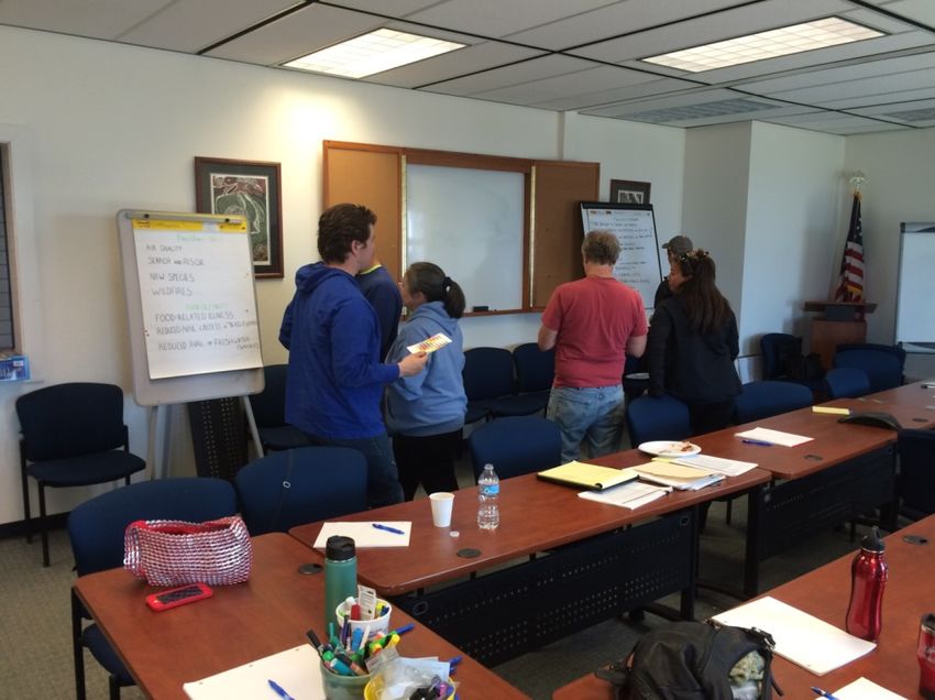
Other Outreach Activities. The Nome tribal climate adaptation plan was also presented at the Alaska
Forum on the Environment (2016 and 2017) and National Adaptation Forum (2017).

Figure 4: Jacob Martin (Tribal Resource Director for the Nome Eskimo Community) discusses the Nome Tribal
climate adaptation plan at the 2017 National Adaptation Forum, panel session “From research to action: lessons
learned for developing and implementing climate services in underserved communities.” (Photo credit: D. Holen)
2. Community Values and Goals
Tribal members shared and discussed several community values, which centered on maintaining
cultural activities and fostering community relationships. Below we briefly summarize the values
discussed during the interviews and workshops, which set the stage for the identification and
prioritization of strategies to address climate change. For more detailed and comprehensive
discussion of community values for the Nome-based tribes, please reference the local economic
development plans for each of the tribal villages (NEC 2015, Kawerak 2011b, Kawerak 2011a,
Kawerak 2013), Kawerak’s website (Kawerak 2016b), and other references (SNC 2016).

Sustaining culture, including singing, dancing, values, traditional knowledge, subsistence,
respect for the environment and community, seasonal activities, and passing knowledge to
younger generations are core values for tribal members in Nome. As discussed by several Elders:

   Where I grew up on King Island was like Paradise Island. I mostly live with the subsistence way of
   life…Living in Nome and the value, with keeping up with our culture and passing on to our younger
   generation as much as we can…The value of my life and my culture. I learn nowadays from my
   parents and my grandparents, uncles, and aunts. My Elders taught me. (Interviewee 4)

   Live off the land. Summer time, spring time I mostly hunt sea mammals, summer time, I hunt off the
   land. Before that, my parents they lived off the Bering Sea, and I followed them, what they do…my
   father passed on, and my uncles showed me how to hunt. (Interviewee 3)
Community and Family, including the need for togetherness, the importance of being willing to
help out during difficult times or emergencies, and familiarity with the community, were also
frequently identified values.

   Having family up here…We have roots here. We enjoy the small community that Nome and this
   region provides…Having the ability to go to fish camp and my family’s traditional hunting and
   fishing grounds. To be able to be out there as much as possible is a big draw for us. Being out on the
   river fishing, being out moose or caribou hunting, picking berries. Having quick access to those kinds
   of activities is the biggest reason for us being here. (Interviewee 10)

In addition, participants frequently mentioned the value of Nome as a hub community (access to
goods and services, airlines, and a diversity of people and organizations in a small town), nature,
freedom and access to the country, being informed, and affordable energy.

   The freedom that we have. I like to be able to walk out of the door of my house, and get on, whether it
   is a snow machine or ATV, and go, almost anywhere you want…there are no real fences or
   boundaries…Nome is small, and you can get from one place to the other in like 5 minutes, 10 at the
   most. (Interviewee 6)
3. Climate-related environmental changes in Nome, Alaska

       “We start seeing things we haven’t seen before” – Village Elder, Nome
Several climate-related environmental changes are occurring in the Nome region, which are
contributing to changing relationships between tribal members and the surrounding lands.
Observations include warmer temperatures, increased storminess, changes in sea ice, less snow
and more rain in the winter, rainier summers, shallower creeks, and permafrost thaw. These
changes pose several risks to tribal members, relating to public health and safety, subsistence,
infrastructure, and increased shipping. This section discusses several climate-related changes and
impacts observed by tribal members living in the Nome region, western science observations,
and scientific projections of future conditions.

   3.1 Temperature
Four key themes were identified for temperature changes in Nome, including
       (1) increased temperatures over the past 100 years,
       (2) a greater increase in temperature during the winter months than other seasons,
       (3) high variability in temperatures during May, and
       (4) projected increases of temperature in the future.

Temperatures have increased over the past 100 years. Tribal members discussed several
long-term observations of temperature change in Nome. These changes were also detected by
climate scientists, who detected a 3.3°F change in temperature between 1949 and 2016 (Alaska
Climate Research Center 2017). Increasing temperatures are contributing to the loss of sea ice,
the introduction of new species, and are impacting food security, as subsistence fish and meats
are spoiling on drying racks.

   Normally, you be seeing below zero temperatures or at least around zero, but we haven’t seen much
   of that this year (Interviewee 10)

   The weather back in the 50’s was colder and the ice was thicker, and to me as someone growing up in
   King Island, it was more fun. (Interviewee 4)

Temperatures have increased the most in the winter and the least in autumn, according to
western science observations. Since 1949, temperatures increased 5.6°F in the winter months and
1.8°F in the autumn. The spring and summer increases have been 3.3F and 2.3F, respectively
(Alaska Climate Research Center 2016).

The timing of spring varies considerably each year according to both community members
and climate scientists (Figure 4). Changes in the timing of seasons are a concern, especially in
relation to the availability of subsistence resources and regulations. For example, the earlier
arrival of subsistence species is a problem when existing regulations do not permit hunting or
fishing until later in the year.

   Springtime will happen anywhere from early April all the way to this last spring [2015] when it was
   in June. (Interviewee 2)
Figure 5: Temperature variation in May. The purple line shows changes in the average annual
temperature. The blue line shows the trend line that fits most closely with the increase in
temperature (NCEI 2016).
Temperatures are likely to continue to rise in Nome during each month of the year, as
indicated by western science. The largest increases will likely continue to be in the winter, due in
part to the reduction of sea ice. The average monthly temperatures in October are likely to
change from below freezing to above freezing. There is a greater range of potential future
temperature changes for the winter than the summer months according to climate scientists.
Figure 6: Projected temperature change in Nome. The yellow, orange, and red bar colors
represent a time period in the future. Colored bars are grouped by month. The vertical black lines
in each bar represents uncertainty, or the range of potential change shown by different climate
models (SNAP 2016). snap.uaf.edu/sites/all/modules/snap_community_charts/charts.php
3.2 Permafrost thaw
Permafrost is thawing at an increasing rate across the Arctic, as observed by tribal members and
western scientists. These changes are leading to several impacts of concern for the Nome-based
tribes. Western scientists expect continued permafrost thaw across the Nome region.Permafrost is thawing across the Seward Peninsula, which is impacting culturally sensitive
sites, roads, and buildings. These changes are becoming very expensive for the community.
There are also several ecological changes associated with permafrost thaw, including increased
sediment loads in rivers from faster erosion and shallower creeks (ground absorbing more water)
that are of concern. As stated by tribal members of Nome:
Our graveyard [in Solomon] is up on an embankment…and the bank is sloughing off with the melt of
the permafrost. We are worried that we will eventually have to deal with exposed coffins and having
to rebury people. (Interviewee 9)
With the permafrost melting, the river banks are eroding faster. It is also contributing to the sediment
load in the river and then redepositing that sediment in other areas that may affect access and
property boundaries via the river. (Interviewee 10)
Every year, or so we have to level our buildings out there, it’s becoming a more and more expensive
for us to do that...The building didn’t move much at all, from 1956 to 2002. (Interviewee 5)
Figure 7: Cemetery at Solomon. Community members are concerned that thawing permafrost and erosion will lead
to coffins being unearthed and exposed. (Photo credit: ACCAP)
Changes in permafrost are expected to continue in the future across the Seward Peninsula
according to western scientists (Alessa et al. 2008a). The figure below shows potential changes
in permafrost temperatures at 1-meter depth. Note average annual soil temperatures are expected
to exceed 32°F across the entire Seward Peninsula by 2040-2050.
2001-2010 2041-2051 2091-2100
Figure 8: Projected soil temperature change at a depth of 1 meter (3ft.). Estimates are based on a high
level of future greenhouse gas emission (SRES A2). [modified from: UAF Geophysical Institute
Permafrost Laboratory.]3.3 Sea ice
Tribal members identified many ways that sea ice has changed in Nome, including later
formation and earlier melting, how it forms, and thickness. These observations are consistent
with observations from climate scientists. These changes make travel more dangerous, limit
opportunities for subsistence, and pose risks for marine mammals. There are also impacts to
commercial and subsistence economies (e.g., spring crabbing) and seal hunting on the ice.
Sea ice is forming later and melting earlier, which is leading to more open water days. Several
Elders discussed how sea ice traditionally formed by the end of October or early November, and
currently the sea ice is forming by mid-late December. In recent springs, shore ice is melting by
the early part of May. As stated by village Elders in Nome:
Growing up here, and seeing how it used to be, the ocean would be frozen solid by the end of October
or early November. Now we are still seeing open water in mid- or late December these days.
We used to have shore ice until May, end of May maybe, but now that first part of May comes around
most of the ice is out. (Interviewee 3)
An increase in the number of open water days is also observed by western science (Figure 9).
Figure 9: Open water days in Nome (Rolph et al. in review). The blue line represents
annual changes in open water days. The green line represents the long-term change.
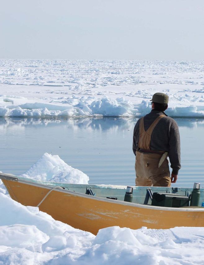
Figure 10: Open water in Norton Sound along the Nome-Council road in November 2015. (Photo
credit: ACCAP)
4Sea and shore-fast ice are getting thinner and blowing away faster. As described by tribal
members in Nome:
When I was little, the sea ice thickness and shore ice thickness used to be 5-6 feet thick. Now we are
lucky if it gets 3 feet thick. (Interviewee 2)
It won’t thicken in winter time no more. That’s what makes the ice go away faster [when the wind
blows] … I used to see icebergs from glaciers that would…float down, you don’t see those no more.
(Interviewee 3)
We have more ice breakouts. We’re afraid to go out over the sea. (Workshop Participant)
Sea ice is melting faster and forming slower. As described by an interviewee and climate
science, respectively:
The ice blow away faster and melt faster today than when I used to go hunting and when I was a
young man. (Interviewee 3)
Figure 11: Number of days it takes to change from at least 30% sea ice to break up (left) and from
open water to 30% sea ice (right). (Rolph 2017).
The observed changes in sea ice will likely continue in the future, as described by climate
scientists. By 2050, the winter ice cover south of the Bering Strait is projected to be about half
the average of recent decades (Overland and Wang 2007). Some models and other approaches
predict an even faster loss of sea ice.
3.4 Increased shipping
Arctic vessel activity in the Bering Strait has increased in the past decade (ICCT 2015). For
example, the cruise ship industry has already made a commitment to increased use of the region
by ice-strengthening the Crystal Serenity, which cruised Arctic waters for the first time in
August 2016.Figure 12: Arctic vessel activity 2008-2013 (ICCT 2015).
Reduced sea ice cover presents an opportunity for increased shipping activity in the Bering
Strait in the future. It is difficult to project the level of future shipping activity in the northern
Bering Sea because future economic and regulatory activities, which influence marine transport,
cannot be known with certainty. Nevertheless, there will very likely be an increase of ship traffic,
representing a continuation of recent trends (ICCT 2015).
Figure 13: Projections of US Arctic vessel traffic (ICCT 2015).
Increased shipping is a concern for the Nome-based tribes and tribes across the region
given the continued loss of sea ice (Kawerak 2016a, Huntington et al. 2015). Although increased
shipping will lead to some economic development, other concerns include:
• Increased potential for accidents (oil spills);
• Increased tourism, which may exceed the capacity of local infrastructure;
• Given the remoteness of the region, local communities may be the first responders to
future oil spills and other emergencies but have limited capacity (lack of equipment,
facilities, and training); and
• Impacts to subsistence hunting and fishing, including:
o Migration routes for some marine mammals may change due to increased vessel
traffic,
o Discharges of grey and black water from ships,
o Small/personal watercraft from cruise ships (noise pollution), and
o Commercial fleets moving northward following fish.3.5 Storminess
Norton Sound is particularly vulnerable to storm surges because the orientation of the Sound
opens to the west. This exposes the region to a long fetch, or area where the wind blows in the
same direction and generates large waves. Further, shallow depths (~60 feet or less) contribute to
the development of larger waves. Because the coast is now protected by sea ice for a shorter
season, coastal storms cause more flooding and erosion, even without an increase in the number
and intensity of storms (Overeem et al. 2011).
Storm impacts have been increasing, primarily because the open water season is longer and
there is more open water to generate waves and storm surge.
While the total number of storms has not changed significantly (black bars), the total
number of storms on open water (red bars) has increased (1950-2010), as reported by
western scientists (Figure 13).
Participants noted that thunderstorms are a new phenomenon. There is concern that increasing
thunderstorms may lead to more wildfires, especially as permafrost thaws.
Figure 14: Trends in strong storms for the entire northwest coast of Alaska (Nome to Barrow).
Black bars represent total number of storms per decade. Red bars represent storms with open
water per decade (Figure provided by W. Chapman, University of Illinois).
3.6 Coastal erosion
Coastal erosion is occurring across several sections of the coastline in the Nome region, but
it is not happening as fast as other areas in Alaska, as reported by both western science and tribal
members (USACE 2009, Macander, Swingley and Spencer 2014, Gorokhovich and Leiserowitz
2012). Erosion is caused primarily by storm surges that coincide with high tides and wind, such
as the November 2011 Bering Sea Storm (Kinsman and DeRaps 2012). A sea wall in Nome
protects most of Front Street. However, several village coastal lands of the Nome-based tribes,
are unprotected.
There are some camps down at Ft. Davis…when I was little, the high bank was extended in front of
my grandparent’s cabin maybe 80 feet, but now it is down to about 40 feet. It has eroded that much in
35 years. (Interviewee 2)Historical maps detailing shoreline erosion in Nome will soon be released by the State of Alaska
Division of Geological and Geophysical and Surveys. http://maps.dggs.alaska.gov/. Information
from these maps should be appended to future versions of this plan.
Coastal erosion is impacting transportation, fish camp structures, access to greens-picking
areas, and cemeteries. Tribal members observed several changes, including bank erosion at fish
camps, which limits access to beaches, boat landing sites, anchor locations for subsistence fish
nets, and has led to damaged fish camp structures. Sections of the Nome-Council Road often
wash out during storms, and repairs are frequent. Damage to a road at Nook (southern extent of
Safety Sound) restricts access to subsistence sites. Coastal erosion has eroded away nearly half
of the Eskimo Cemetery Track A. Within the remaining area, a ground penetrating radar survey
found 84 potential locations of human burials, buried 2.1 - 2.9 ft. below ground (Bowman 2014).
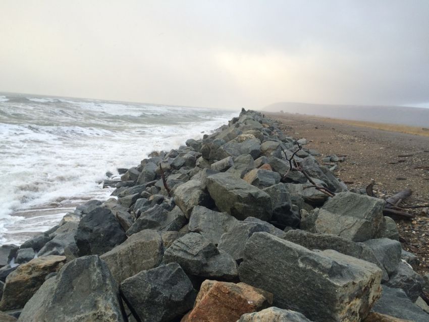
Figure 15: Nome Eskimo Community Cemetery. The approximate boundary of the cemetery is
between the sea and the line of rocks). Nearly half of the cemetery has already been eroded.
During this time, some human remains have been washed out to sea. Many of those buried here
died during the 1918 Spanish flu epidemic. (Photo credit: ACCAP)
Erosion is likely to continue in the future in several areas, according to western scientists. It
is difficult to know exactly how fast the coastline will erode in the future. However, it is possible
to estimate how much the coastline may change based on historic data. The Coastal Hazards
Program at the State of Alaska Division of Geological and Geophysical Surveys has developed a
Shoreline Change Tool that diplays potential future shorelines. The website provides information
on potential future shorelines and guidance on how to use the online tools
(maps.dggs.alaska.gov/). The coastline for Nome will soon be added.
3.7 Precipitation
Changes in wetness and dryness have been reported in Nome by tribal members, but these
changes are difficult to relate to official data on precipitation because
(1) precipitation measurements have errors (Benning and Yang 2005), especially in
measuring blowing snow;
(2) precipitation amounts can vary significantly over short distances; and
(3) ground wetness depends on evapotranspiration in addition to precipitation. Nevertheless,
there are indications that precipitation has increased during the summer in Nome since
the 1960s (NOAA 2017).
Summers are rainier over past 50 years (27% since 1960), though there have been wetter
periods in the past (1920s and 1950s), as indicated by western science (NOAA 2017). Rainier
summers during times that fish and meat are dried on outside racks are a concern for tribal
members, as this can lead to food spoiling.In the winter, more precipitation is falling as rain and less is falling as snow, especially
compared to 30-50 years ago, as revealed by both tribal Elders and western science (Groisman et
al. 2016). These changes in winter precipitation are a concern for tribal members for several
reasons. Berry production (black, blue, and salmon), for example, depends on spring snow melt
to saturate the soil, and there isn’t enough spring rain to make up for the lack of snow. Berry
plants are especially vulnerable given the additional stressors of muskox eating berries and berry
roots and the drying of lakes, which reduces habitat for animals (Kellogg et al. 2010). The loss of
snow also affects animals by making it more difficult for some animals to blend into the
environment, so animals may be compelled to migrate when the environment changes. Lack of
snow also makes it more difficult for people to travel into the country, especially during the
transition seasons, when the snow isn’t adequate to run a snow machine, but the ground is too
soft to run an ATV. Longer, warmer springs are a problem for mobility.
We used to have a lot more snow from the 1960’s until about 2000. In Nome, from the 60’s until
today, we used to have a lot more snow, lots of snow, and it used to be deeper, and the ice used to be
deep and covered with snow. Probably 3-4 feet deep. (Interviewee 4)
I remember…a lot more snow. I remember jumping off of houses here, doing what kids do, because
the snow drifts were as high as the houses. (Interviewee 10)
Precipitation will likely increase in northern high latitudes, though the ground will become
drier, as suggested by western science (IPCC 2013). The amount of change depends on the
underlying emission scenario used for greenhouse gases. For higher emission scenarios (i.e., the
current situation), precipitation increases of 20-30% are expected for the Seward Peninsula by
2050. However, the projected increase of evapotranspiration (drying) due to higher temperatures
is at least as large as the expected increase of precipitation, so the ground will actually become
drier during the summer despite increased precipitation. At a minimum, longer spells of dry
conditions should become more common.
Figure 16: Historical and potential future precipitation in Nome (SNAP 2016).
snap.uaf.edu/sites/all/modules/snap_community_charts/charts.php3.8 Tundra lakes and ponds are drying
On the Seward Peninsula, the primary driver of lake shrinkage appears to be drainage associated
with permafrost thaw. Increased evaporation due to warmer temperatures appears to be a
secondary driver.
Tundra lakes and ponds are getting smaller and disappearing, as observed by village Elders
and climate researchers (Alessa et al. 2008b, Hunt, Yu and Jones 2013, Hinzman 2005),
especially over the past 50 years.
I’m seeing some of the lakes dry up that used to contain water. (Interviewee 5)
The reduction of tundra lakes and ponds is impacting the migration of animals, subsistence
practices, and the availability of freshwater resources. There is less tundra pond habitat, and
fewer migratory birds are stopping in the area. This is a concern for community members who
rely on eggs and game birds for subsistence. It also contributes to increased travel distance, time,
and costs. Driving farther away from communities on snow machines and ATVs has implications
for noise pollution, which affects animal movement. There are also changes in the timing of
arrival of species important for subsistence (migratory birds) and the arrival of new species
(beavers, grosbeaks, red ants, lynx, muskox (introduced), bears, insects). For details on impacts
to community water resources, see (Chambers et al. 2007).
3.9 Wind
Western science information on changes in wind for Nome is less reliable because official
National Weather Service data are based on anemometer (devices to measure wind speed)
readings of different heights. Local knowledge provides several insights into the wind.
The wind changes quite a bit, we got mostly easterly wind now, all the time, sometimes northerly, and
when it’s winter time, easterly wind comes, and then it will bring warm weather in winter time too,
that easterly wind. (Interviewee 3)
This time of the month [mid-December], in wintertime, we have north wind all the time, and now we
are having south wind. (Interviewee 4)
Today, we have a lot of wind blowing, steady winds this time of the month. Back in those days, it
would hardly be windy. It would snow more and hardly rain. (Interviewee 4)
We are getting more high tides from up north which come down. It is due to high tides and currents
and the wind, and blizzard mixed with rain, which I never used to see before until 1970’s. Right now,
we are having high tide out there, having east wind, and I really thought it was going to blow from
the south to bring in all that waves. (Interviewee 4)
3.10 Sea level rise
Long-term trends in sea level are not available in Nome. Observations are only available
since 1992. It generally takes 30 years to develop a reliable trend in sea level. The limited data
suggests relative sea level rise in Nome is about 0.5mm/year, much less than the global average(DeGrandpre 2015). Climate scientists believe that coastal erosion and flooding will likely be
affected more by changes in sea ice and storms than by changes in the background sea level.
Figure 17: Changes in sea level in Nome, Alaska (PSMSL 2017).
3.11 Other climate-related changes and concerns in Nome
Creeks are shallower, primarily due to permafrost thaw allowing the ground to absorb more
water. There is also less snowfall leaving less water to distribute in the spring and summer.
People are concerned that springs coming out of the hills will not be able to maintain a high
enough water table to have fresh water for drinking. They are also concerned that streams won’t
have enough water during the salmon spawning season. Further, stream depth has an incremental
effect on salmon smolt survival in the winter, as shallower creeks are more vulnerable to freeze
up. Pink salmon are easily impacted by habitat changes. For additional observations and impacts
to arctic freshwater systems, see White et al. (2007).
New species: Participants noticed more and taller shrubs, new insects, more jellyfish, and the
arrival of killer whales. Shrubification, which has implications for berries, greens, and lichens, is
especially a concern among reindeer herders.
Public health and safety was one of the major cross-cutting concerns. This includes changes in
the availability of traditional foods, infectious diseases due to invasive microorganisms,
unknown diseases for marine mammals, increasing dust in the summer (berries, fish, and
breathing impacts), and availability of freshwater resources.
Potential increase in wildfire activity due to permafrost thaw, more shrubs on the tundra,
increasing temperatures, and more thunderstorms.
Impacts to fishing associated with changes in the availability, timing, health, and location of
fish species for subsistence. Some fish species are less available, such as hooligan, which
traditionally provided fresh fish in the spring. One Elder mentioned that fish camps are moving
upriver near Teller with the migration of Pacific tomcod. Tomcods appear to have more tumors.
Impacts to mammals centered on the health of animals for consumption and implications for
food security. Several participants expressed concern about catching deformed seals, which are
not viewed as safe to eat. Some of the concern comes from recent studies that show marinemammals are absorbing paralytic shellfish poisons (PSPs) by eating resources at lower trophic levels such as shellfish and some freshwater fish. There were also concerns about the shifting ranges of brown bears, which are frequenting fish camps, and muskox, which are damaging berries and greens “The musk ox are eating the black berries, stop growing because of musk ox, they pull out roots. Musk oxen are also eating some sour dock, these greens." There have also been shifts in the timing of when the walrus show up in Nome over the past 10-12 years (in April rather than May and June). “It’s risky to hunt walruses that time of year.” Changes in sea ice conditions have also led to changes in hunting. There are also concerns about rain on snow events and wind among reindeer herders (Rattenbury et al. 2009).
4. Climate Adaptation Initiatives
Eight climate adaptation initiatives were identified and approved by the Steering Committee.
These initiatives focus on addressing impacts related to public health and safety, subsistence and
food security, increased shipping, and infrastructure. The following themes are integrated into
many of the initiatives:
   (1) supporting opportunities to share traditional knowledge and engage youth and Elders;
   (2) using local materials, labor, and expertise, whenever possible; and
   (3) learning from Elders and other communities.

                                             Initiatives
 1. Adapt food preservation techniques for changing weather and climate conditions
 2. Promote the use of traditional food preservation techniques that are less energy intensive
    than freezers
 3. Reconnect families to subsistence resources
 4. Increase awareness of near-term climate and related environmental conditions
 5. Increase tribal representation in subsistence management
 6. Protect tribal cemeteries from erosion
 7. Support research and monitoring
 8. Build capacity for addressing concerns about increased shipping

6.1 Adapt food preservation techniques to improve food security. Fish and other meats are
spoiling more often on drying racks because warmer temperatures make the meat dry too fast.
Fish on drying racks turns “gummy” and becomes dangerous to eat when temperatures exceed
~75°F for 3 or more days. Prolonged periods of rain that occur after the fish and meats are placed
on racks also contributes to food safety concerns. Tribal members want to dry meats successfully
and not lose harvested food.

   Strategy #1: Provide opportunities to learn about how tribal members across the Bering
   Strait region are adapting food preservation techniques.
      Actions:
      (1) Use existing conferences and venues to discuss how tribal members are adapting food
           preservation techniques to reduce drying times. Consider having live demonstrations.
           Start with local venues (Kawerak Regional Conference) then organize statewide
           events (Alaska Federation of Natives).
      (2) Use social media to start conversations (Facebook, NomePost, NomeRant, Bering
           Straits listserv, Nome Announce, Local Environmental Observers Network). Get
           feedback and responses on what works and what doesn’t.

   Strategy #2: Scope the building of adaptable meat drying racks for warmer, wetter, and
   more variable weather that could control the temperature and moisture.
Actions:
(1) Determine local preferences for dried meat. This information will help develop design
standards and ensuring that the final food products align with what people want.
(2) Obtain engineering designs. Designs must use local resources and labor, whenever
possible. Most fish racks are built with driftwood and a few nails and screens.
6.2 Promote the use of traditional food preservation techniques that are less energy
intensive than freezers, to provide opportunities for sharing traditional knowledge and reducing
energy costs.
Strategy #1: Continue to support opportunities for Elders to show youth how to
preserve food using traditional methods, such as canning, seal oil, and salting.
Strategy #2: Host trainings on fish drying, such as through a community fish rack or
annual youth-Elder camps.
6.3 Reconnect families to subsistence resources, especially for those with limited access to fish
racks, transportation, gear, and camps.
Strategy #1: Explore opportunities for working with village corporations to develop a
community fish rack.
Actions:
(1) Acquire land use permits from the land owner.
(2) Acquire materials and funds, including gravel (from either the land owner or Bering
Straits Native Corporation), locally available driftwood for the drying rack.
(3) Seek funds for a picnic bench.
(4) Build rack and host community event.
6.4 Increase awareness of weather and climate and related environmental conditions. Tribal
members need to be aware of the weather for subsistence hunting and food preservation.
Strategy #1: Enhance opportunities for sharing traditional knowledge of local weather.
Actions:
(1) Support opportunities for Elders to share stories in the school systems. Partners include
school Youth Activity Coordinators and Kawerak’s subsistence coordinators and social
science program.
(2) Hold a special break-out group at Kawerak’s annual Elder-youth regional conference.
6.5 Increase tribal participation in subsistence management that aligns with the shifting
availability of subsistence resources. There has been some involvement with advocating for
changes in management for bears and caribou (McNeeley 2012), but further work is needed on
adjusting for migration and weather changes.
Strategy #1: Advocate for formally designated tribal seats on subsistence management
councils and boards, including the North Pacific Fisheries Management Council, to work
4with NOAA, National Marine Fisheries Service, and Alaska State Board of Fisheries and
Board of Game.
Strategy #2: Increase involvement in working with federal regional advisory councils
and state boards for regulatory changes.
Strategy #3: Enhance capacity for tribal members to keep and strengthen open
relationships with regulators.
Actions:
(1) Provide trainings for tribal members on how to attend, participate, and conduct
oneself (talk effectively to board members) in regulatory meetings.
6.6 Protect tribal cemeteries from erosion. Cemeteries for the Nome-based tribes (NEC Track
A mass grave and Solomon) are eroding. Future degradation may expose community members to
Spanish influenza from victims of the 1917-1918 epidemic.
Strategy #1: Develop a long-term solution to protect culturally significant grounds and
public health (for Eskimo Cemetery Track A).
Actions:
(1) Work with the City to designate area as a cemetery. Currently zoned industrial.
(2) NEC work with Sitnasauk to develop a MOU for management of cemetery.
(3) Obtain rates of shoreline change.
(4) Protect coastline from future erosion (e.g., armoring).
(5) Make it look like a cemetery.
(6) Learn from other communities.
(7) Need to identify an engineer to help develop plan.
6.7 Support research and monitoring. Coordination is needed among outside researchers, local
land owners, and tribal environmental programs to support research on fisheries and permafrost
thaw. This research is needed to guide planning decisions under a changing climate. Outside
researchers obtain permits to conduct studies on tribal lands from village corporations but rarely
coordinate their plans with tribal science programs. There can be limited communication
between tribal land owners and science programs. This results in tribal science programs not
aware of local research being conducted. A recent database of coastal monitoring and research
programs in western Alaska provides a starting point for identifying research that is happening
and who is funding it, but there is no mechanism for updating (Brown, Knapp and Trainor 2016).
Strategy #1: Expand data collection and monitoring efforts of key system variables for
fisheries, including temperature, streamflow, pH, and dissolved oxygen, along multiple
transects in streams such as: Dry Creek, Nome River, Livingston Creek, Penny River,
Christian Creek, and Grand Central River. Such research could inform the extent that salmon
enhancement efforts (e.g., hatcheries) can be supported in the future, or whether new species
may be better adapted to the changing environment.
Strategy #2: Map the location of permafrost and slope stability in the Village of
Solomon. Tribal members in Solomon are interested in having permanent residents inSolomon. Any new construction should consider the location of permafrost. Slope stability is
also a concern, especially in relation to erosion along the village cemetery. Information on
the location of permafrost is also needed for planning activities relating to the Solomon Bed
and Breakfast, which is located on thawing permafrost.
Strategy #3: Continue posting observations to the LEO network to share observations
with other communities across Alaska. Increase number of LEO observers.
Strategy #4: Facilitate coordination among researchers, village corporations (land
owners), and tribal environmental programs.
Actions:
(1) Develop MOA/MOU’s between tribal land departments and resource departments to
enhance communication between tribal land owners and research programs to ensure
researchers receiving appropriate land permits also communicate with tribal
environmental research programs.
(2) Pass tribal resolutions that research conducted by outside agencies/organizations must
be approved by the tribal council. Considerations for the resolutions include: time
sensitive nature of projects, and the size of project funding (i.e., projects above a certain
size might require approval, while smaller projects may simply require a land permit).
6.8 Build capacity for addressing concerns about increased shipping and oil spills. There is
a desire for more immediate local responses to oil spills, rather than waiting for agencies and
corporations to respond.
Strategy #1: Continue to provide local responder training for oil spills.
Actions:
(1) Seek funding by writing grants (Environmental Protection Agency, AK Dept. of
Environmental Conservation, Coast Guard, & Norton Sound Economic Development
Corp.) to support HAZWOPER (Hazardous Waste Operations & Emergency
Response) & HAZMAT (Hazardous Materials) trainings & hire a contractor to
identify equipment needed for oil spill response in sensitive areas.
Strategy #2: Obtain materials for local responses to oil spills.
Strategy #3: Learn how other villages have worked with shipping companies to route
activities away from subsistence areas.
Strategy #4: Advocate for Alaska Native priorities for marine issues.
Actions:
(1) Continue to support Kawerak’s advocacy work.
(2) Communicate priorities, best practices, and recommended codes of conduct to the
Arctic Waterways Safety Committee (AWSC), which is developing guidelines for
marine vessels that will be required by insurance companies (Kawerak 2016a).
(3) Provide input into the Northwest Arctic Subarea Contingency Plan to ensure tribal
concerns for oil spill planning and response are communicated to the Coast Guard or
Alaska Dept. of Environmental Conservation.7. Implementation Plan
Participants discussed several possibilities for moving forward. This section outlines an
implementation plan for three priority and immediately actionable initiatives discussed above.
Timelines and potential funding sources are discussed. It also discusses actions to ensure the plan
is updated and revised, as priorities are addressed or change.
A) Reconnect families to subsistence resources
Strategy #1: Explore opportunities for working with village corporations to develop a community
fish rack.
Actions Estimated Potential Funding
Timeline
Acquire land use permits from land owner. Winter 2017 N/A
Acquire materials and funds, including: (1) Acquire Spring 2018 Land owner (village
gravel from either the land owner or Bering Straits corporation); Bering
Native Corporation, (2) Use locally available Straits Native
driftwood for the community fish drying racks, (3) Corporation, NSEDC
Seek funds for a picnic bench. Potential funding
sources include the land owner or NSEDC.
Build rack and host first community event. Summer 2019 N/A
B) Protect tribal cemeteries from erosion
Strategy #1: Develop a long-term solution to protect culturally significant grounds and public
health (for Eskimo Cemetery Track A).
Actions Estimated Potential Funding
Timeline
Begin communicating and working with the City to Summer 2017 Sitnasuak Native
designate area as a cemetery. Corporation; National
NEC work with Sitnasuak to develop a MOU for Summer 2017 Park Service; National
management of cemetery. Historic Preservation
Obtain rates of shoreline change from Alaska Spring 2018 Act of 1966 (section
DGGS Coastal Hazards Program. (est. availability) 106)
Make it look like a cemetery. Summer 2018
Learn from other communities. Summer 2018
Protect coastline from future erosion, including Fall 2018
identification of engineer to develop a plan.C) Build capacity for addressing concerns about increased shipping
Strategy #1: Continue to provide local responder training for oil spills.
Actions Estimated Timeline Potential Funding
Support HAZWOPER and HAZMAT trainings. Spring 2018 EPA, AK DEC,
Hire a contractor to help identify equipment Fall 2018 Coast Guard,
needed for oil spill responses for sensitive areas. NSEDC; write into
IGAP Work Plan
Strategy #2: Obtain materials for local responses to oil spills
Obtain materials for local responses to oil spills. Winter 2018 Coast Guard, EPA
IGAP
Strategy #3: Learn how other villages have worked with shipping companies to route activities
away from subsistence areas.
Contact other villages, start with phone calls. Winter 2017 N/A
Strategy #4: Advocate for Alaska Native priorities for marine issues
Continue to support Kawerak’s advocacy work. N/A
Communicate priorities, best practices, and N/A
recommended codes of conduct to the Arctic
Waterways Safety Committee.
Provide input into the Northwest Arctic Subarea Ongoing N/A
Contingency Plan to ensure tribal concerns for
oil spill planning and response are
communicated to the Coast Guard or Alaska
DEC.
D) Provide opportunities for updates, feedback, and evaluation to ensure the climate
adaptation plan remains a living document. The NEC Tribal Resource Director will
request annual updates from the tribes. The NEC Tribal Resource Director will also
organize a brief annual meeting, if necessary. These events will provide opportunities to
discuss the status of existing initiatives and changes in priorities. Data and documentation
associated with completed priorities will be added as appendices to this plan, when
available and relevant.8. References
ADLWD. 2017. American Community Survey. State of Alaska.http://live.laborstats.alaska.gov/cen/acsarea.cfm
Alaska Climate Research Center. 2016. Temperature Changes in
Alaska.http://akclimate.org/ClimTrends/Change/TempChange.html
---. 2017. Total Change in Mean Seasonal and Annual Temperature 1949-2016. Fairbanks, AK: Geophysical
Institute, University of Alaska
Fairbanks.http://climate.gi.alaska.edu/sites/default/files/ClimateTrends/Seasonal_Yearly_Temp_Change_F.png
Alessa, L., A. Kliskey, R. Busey, L. Hinzman & D. White (2008a) Freshwater vulnerabilities and resilience on the
Seward Peninsula: Integrating multiple dimensions of landscape change. Global Environmental Change, 18,
256-270.
Alessa, L., A. Kliskey, A. Williams & M. Barton (2008b) Perception of change in freshwater in remote resource-
dependent Arctic communities. Global Environmental Change, 18, 153-164.
Benning, J. & D. Yang (2005) Adjustment of daily precipitation data at Barrow and Nome Alaska for 1995-2001.
Arctic, Antarctic, and Alpine Research, 37, 276-283.
Bowman, R. 2014. Nome Eskimo Cemetery: Ground Penetrating Radar Analysis. 16. Fairbanks, AK: Northern Land
Use Research Alaska, LLC
Brown, C. L., C. N. Knapp & S. F. Trainor. 2016. Current coastal change projects and priority information needs in
western Alaska. 37. Fairbanks, AK: Alaska Center for Climate Assessment and
Policy.https://westernalaskalcc.org/projects/Lists/Project Products/Attachments/125/Coastal Change Projects
Western Alaska 2015.pdf
Chambers, M., D. White, R. Busey, L. Hinzman, L. Alesa & A. Kliskey (2007) Potential impacts of a changing
Arctic community on water resources on the Seward Peninsula, Alaska. Journal of Geophysical Research, 112.
Cochran, P., O. H. Huntington, C. Pungowiyi, S. Tom, F. S. Chapin III, H. P. Huntington, N. M. Maynard & S. F.
Trainor (2013) Indigenous frameworks for observing and responding to climate change in Alaska. Climatic
Change, 120, 557-567.
DeGrandpre, K. G. 2015. Relative sea level change in Western Alaska estimated from Satellite Altimetry and repeat
GPS measurements. 174. Fairbanks, AK: University of Alaska Fairbanks
Fall, J. A. 2014. Subsistence in Alaska: a year 2012 update. Alaska Department of Fish and Game, Division of
Subsistence.http://www.adfg.alaska.gov/static/regulations/regprocess/gameboard/pdfs/2013-
2014/Statewide_03-14-14/rcs/rc011_ADFG_Subsistence_Update.pdf
FEMA. 2010. Flood insurance study. City of Nome, Alaska Nome Census area., 16. FEMA
GAO. 2009. Alaska native villages: limited progress has been made on relocating villages threatened by flooding
and erosion. 53.http://www.gao.gov/products/GAO-09-551
Gorokhovich, Y. & A. Leiserowitz (2012) Historical and future coastal changes in Northwest Alaska. Journal of
Coastal Research, 28, 174-186.
Groisman, P. Y., O. N. Bulygina, X. Yin, R. S. Vose, S. K. Gulev, I. Hanssen-Bauer & E. Forland (2016) Recent
changes in the frequency of freezing precipitation in North America and northern Eurasia. Environmental
Research Letters, 11, doi:10.1088/1748-9326/11/4/045007.
Hinzman, L. D., et al. (2005) Evidence and implications of recent climate change in northern Alaska and other arctic
regions. Climate Change, 72, 251-298.
Hunt, S., Z. Yu & M. Jones (2013) Late glacial and Holocene climate, disturbance and permafrost peatland
dynamics on the Seward Peninsula, western Alaska. Quaternary Science Reviews, 63, 42-58.
Huntington, H. P., R. Daniel, A. Hartsig, K. Harun, M. Heiman, R. Meehan, G. Noongwook, L. Pearson, M. Prior-
Parks, M. Robards & G. Stetson (2015) Vessels, risks, and rules: planning for safe shipping in Bering Strait.
Marine Policy, 51, 119-127.
ICCT. 2015. A 10-year projection of maritime activity in the U.S. Arctic Region. 73. Washington, D.C.: The
International Council on Clean Transportation.http://www.cmts.gov/downloads/CMTS_10-
Year_Arctic_Vessel_Projection_Report_1.1.15.pdf
IPCC. 2013. The physical science basis. In Contributions of Working Group I to the Fifth Assessment of the
Intergovernmental Panel on Climate Change, ed. T. F. Stocker, D. Qin, G.-K. Plattner, M. Tignor, S.K. Allen,
J. Boschung, A. Nauels, Y. Xia, V. Bex and P.M. Midgley. Cambridge, UK:
Kawerak. 2011a. Native Village of Council Local Economic Development Plan. ed. P. Mikulski, 45. Nome, AK:
Kawerak.http://www.kawerak.org/ledps/council.pdf
---. 2011b. Solomon Local Economic Development Plan 2011-2015. ed. A. Saito, 64. Nome, AK:
Kawerak.http://www.kawerak.org/ledps/solomon.pdfYou can also read