Sustainable Planning in a non-Sustainable Situation: The Case of Jerusalem - ISOCARP
←
→
Page content transcription
If your browser does not render page correctly, please read the page content below
Khamaisi, R.-sustainable in Jerusalem, 46th ISOCARP Congress 2010, Nairobi, Kenya

Sustainable Planning in a non-Sustainable Situation: The Case
of Jerusalem
                                                                         Rassem Khamaisi

Introduction

Sustainability in planning and development consists one of the main issues placed on
the agendas of planners, development and decision makers. Since the beginning of the
1990’s, and particularly after Rio de Janeiro summit 1992 and, later, Agenda 21 of the
UN, public awareness has grown. The notion of sustainability is based on environmental
and ecological considerations which lead us as people, communities and states, to look
at what is happening to our environmental system in a holistic approach. Part of this
environment is the urban system, which includes the environmental, physical, social and
economic fabrics.

The question of how to develop a sustainable urban system is one of the main topics
that engage planners and developers in cities which do not suffer from national conflict.
Conflicts as such threaten any possibility of sustainable planning and development.
Thus, the challenges for securing sustainable urbanization and urbanism, particularly in
polarized and segregated cities and communities facing ethno-national conflict, is a topic
that engages and acquires the consideration of urban planners, managers and
developers. There are two approaches to deal with sustainable planning and
development in cities in conflict; one is calm, directed towards solving the conflict or
finding a way for ethno-national conciliation to the conflict, which is a precondition for
sustainable planning and development in such cities, the second approach is using
sustainable planning and development as a way of thinking or an approach for conflict
conciliation. Every approach based on implementation of sustainable activities in cities
has its logic and justifications.

The first approach suggests that the ethno-national conflict, on the national and urban
levels, has a direct impact on any component of the city fabric and activities, therefore
we cannot secure any sustainable planning and development without considering the
geo-political conflict. In this situation, the individual, the community and urban activities
are influenced by the conflict, and the possibility of achieving sustainable development is
unrealistic;a waste of time and effort.

The second approach suggests that in every city you can find conflicts. The difference
between conflicts in different cities is the nature of those conflicts, their levels, their
deepness and size, as well as the relation of the urban conflict to others conflicts.

In many cities we may find conflicts, through which people live. In these cases there are
no contradictions between planning, management and development according to
sustainable notion and principles in the micro and mezzo levels, which may lead to some
acceptance between the parties involved in national conflict on the macro level. The
synergetic and dialectical relations between the micro, the mezzo, and the macro may
lead to conflict conciliations, or, at least, create an environment which helps reach
sustainable development in the current situation and in the future when the situation
changes.

                                              1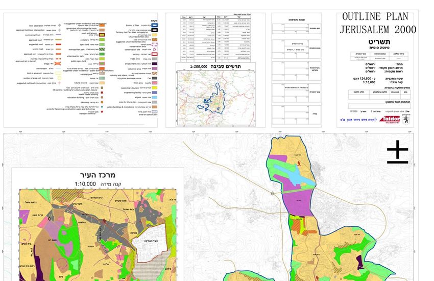
Khamaisi, R.-sustainable in Jerusalem, 46th ISOCARP Congress 2010, Nairobi, Kenya

There are different theories and guidelines about how to cope with rapid urbanization in
order to reach the point of sustainable development in cities. However, there still
remains a constant theoretical and practical vacuum about how to secure urban spatial
planning which can create the basis for a sustainable urban environment in cities or
urban regions under conflict. One such city is Jerusalem. The main themes of this paper
include a discussion about the aforementioned vacuum shedding some light and insight
onto the reasons and the factors of the non-sustainable situation which lead urban
planners and managers to suggest plans that cannot provide sustainable development
to all the citizens and residents of the city.

The paper’s main argument is based on the notion of applied practices which sustain
urban development in situations of partisan planning (Bollens, 2000) that ignores the
rights of all its residents to the city (Khamaisi, 2007). These practices common in
divided, segregated and conflicted cities in fact avoid the principles of development of
urban sustainability. In other words, the right to city in such situations does not exist.
Meanwhile, sustainable planning and development are limited and threaten
environmental resources.

This paper will address environmental sustainability joined with geo-political, socio-
economic and spatial sustainability. It will discuss this argument through describing the
case of Jerusalem, a city undergoing a rapid urbanization process as a result of the geo-
political, demographic and ethno-national competition and conflict over the city. The
paper will discuss how the planners of the last city outline Plan "Jerusalem 2000", dealt
with sustainability in a non sustainable situation.

The paper opens its argument with a short theory which discusses the relation between
sustainability and the right to the city concepts. Later, a short description and discussion
of the existing situation in Jerusalem is discussed. It represents a platform for preparing
outline planning to the city. The third part will show the problem between reaching
sustainable planning and development in the city under rooted geo-political conflict and
socio-economic disparities and gaps between different parts of the city. The paper
concludes by discussing the presented argument and previous approaches , and draws
some policy guidelines for securing planning and development sustainability in the city.

General theoretical framework

The topic of sustainability has been a main topic of international and national
conferences and political agendas, particularly to cope with the environmental and
urbanization challenges and problems. One of the matters is to raise public awareness
and rationalize natural resources consumption, alongside internalization of trans-border
considerations of development (Dasgupta, 2007).

The threat of limited natural resources caused by rapid urbanization, growing population
and consumption leads to more pollution (water, air, landscape, noise ets.) (Hasna,
2007). Pollution is not an aspect that ends at state or city boundaries; it has global,
regional, national and local implications. Various literatures try to define sustainability,
but there is still not one common definition. The common general definition of
sustainability is: "A sustainable society meets the needs of the present without sacrificing
the ability of future generations to meet their own needs"(www.sustainable-
city.org/plan/into/intro.htm). According to this definition, equilibrium has to be found
between the needs of the society and complying their provision in the present, and

                                              2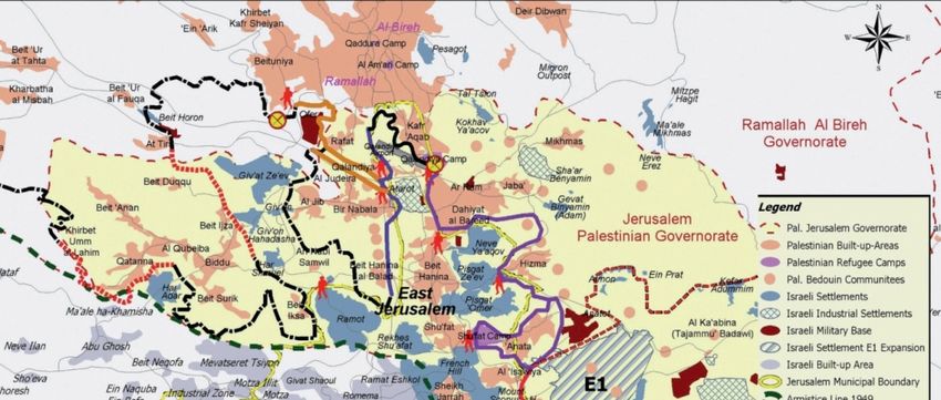
Khamaisi, R.-sustainable in Jerusalem, 46th ISOCARP Congress 2010, Nairobi, Kenya

preserving resources for the future to accommodate the needs of the next generations.
This society behavior leads to sustainable development defined as: "Sustainable
development is a pattern of resource use that aims to meet human needs while
preserving the environment so that these needs can be met not only in the present, but
also for future generations.” The term was used by the Brundtland Commission which
coined what has become the most often-quoted definition of sustainable development as
development that "meets the needs of the present without compromising the ability of
future generations to meet their own needs" (http://en.wikipedia.org/wiki/ Sustainable
development). Sustainable development depends on two major factors: development
and preservation. It is a wise utilization of recourses in a 'smart' way toward growth and
development. Sustainable development upholds two key concepts:

   •   the concept of needs, in particular the essential needs of the world's poor, to
       which overriding priority should be given; and
   •   the idea of limitations imposed by the state of technology and social
       organization on the environment's ability to meet present and future needs."

All definitions of sustainable development require that we see the world as a system—a
system that connects space; and that connects time (http://www.iisd.org/sd/). Part of this
system is including the place. The place contains the human activities in the space,
which include cities where the majority of the humanity lives today. Population growth
and concentration of human activities in cities depicts the needs for planning and
development of sustainable cities. During the preparatory meetings for the 21st URBAN
Conference (Berlin, July 2000) the following definition was developed to define
sustainable urban development: "Improving the quality of life in a city, including
ecological, cultural, political, institutional, social and economic components without
leaving a burden on the future generations; a burden which is the result of a reduced
natural capital and an excessive local debt. Our aim is that the flow principle that is
based on equilibrium of material, energy and also financial input/output, plays a crucial
role in all future decisions upon the development of urban areas."
(http://archive.rec.org/REC/Programs/Sustainablecities/What.html). Another definition:
"Sustainable community development is the ability to make development choices which
respect the relationship between the three "E's"-economy, ecology, and equity”:

   •   Economy - Economic activity should serve the common good, be self-renewing,
       and build local assets and self-reliance.
   •   Ecology - Humans are part of nature, nature has limits, and communities are
       responsible for protecting and building natural assets.
   •   Equity - The opportunity for full participation in all activities, benefits, and
       decision-making of a society."Mountain Association for Community Economic
       Development (MACED): Hart Environmental Data
       (http://archive.rec.org/REC/Programs/Sustainablecities/What.html).

These definitions include different components of the city which lead to creating
economic activities, considering ecological characters of the place, by giving equal
opportunities to the individuals and communities to participate is shaping their space,
place, and considering providing their needs for a better quality of life in healthy
environments. Some institutions set forth efforts to crystallize characters of a sustainable
city (Jarrar and Al-Zoabi, 2008). Some of the sustainability characteristics outlined by the
Centre for Sustainable Development include:

                                              3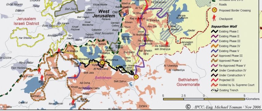
Khamaisi, R.-sustainable in Jerusalem, 46th ISOCARP Congress 2010, Nairobi, Kenya

   •   the formulation of goals that are rooted in respect for both the natural
       environment and human nature, and that call for the use of technology in an
       appropriate way to serve both of these resources;
   •   the placement of high values on quality of life;
   •   respect of the natural environment;
   •   infusement of technology with purpose;
   •   optimization of key resources;
   •   maintenance scale and capacity;
   •   adoption of a systems approach;
   •   support of life cycles;
   •   responsiveness and proactiveness;
   •   value for diversity; and
   •   preservation of heritage. (see: Centre of Excellence for Sustainable
       Development).

Other definitions of sustainable indicators (Boulanger, 2008) were placed by the
Jerusalem Institute for Israel studies, and the Israeli Central Bureau of Statistics
(http://www.cbs.gov.il/statistical/pituach_bar82.pdf).    The      indicators        include
environmental, social and economic components. Some of these indicators are used to
investigate the sustainable situation in Jerusalem (Moriyah, Feuer and Shahin, 2006).
Most of these indicators provide limited consideration to the geopolitical conflict situation
in Jerusalem and for its sustainability development, which include limited right of the
Palestinian residents to the city. Securing the right to the city consists one the main
components of planning and development processes of creating a sustainable city.

The concept of the right to the city stems from guaranteeing people's rights in the city as
equal citizens who should have the ability to move spatially and functionally within the
city's surroundings without impediments or administrative, physical or cultural/national
barriers (Fenster, 2004). This concept evolved in response to the deliberate and direct
restrictions of global geo-political and economic transformations, which imposed political,
economic and functional structures that handicap an individual's rights in the city space
as it is controlled by the central government, multinational companies, or globalization
(Falk, 2000). This central national control may lead to stripping citizens of their right to
participate in formulating decisions concerning designing, planning, managing and
producing the city space (Mitchell, 2003).

The urbanization process the whole world is undergoing and the sharp population
increase in cities, in addition to the concentration of economic resources and
governance and decision-making centers in cities, have attracted researchers interested
in attempting to understand the formation of urban spaces and people's movements
within these spaces, and those who monitor the nature of the relations evolving among
city residents in states of stability and conflict (Harvey, 2003). Lefebvre's concept of the
right to the city evolved from a reality in which the city represents the society's
ramifications on the ground in accordance with the tangible physical meaning, the
intangible discrete meaning, and to taking decisions and formulating ideas which
determine the city's model and its structure formation. The right to the city concept
presents itself as a noble form of rights: the right to freedom and individual and personal
rights within the scope of participation and involvement in the various societal structures,
which include the rights to living, housing and work. The right to the city idea also
includes the right to creativity, participation and allocation (Lefebvre, 1996).

                                              4
Khamaisi, R.-sustainable in Jerusalem, 46th ISOCARP Congress 2010, Nairobi, Kenya
Moreover, the concept of the right to the city originated from the production of the city
space; therefore, whoever lives in the city and interacts with it (which is to say, produces
it) is entitled to demand the right to the city (Lefebvre, 1991). Lefebvre and other
researchers who discussed the concept of the right to the city summarized it in two
major principles: The right to participation and the right to appropriation (Salmon, 2001;
Lefebvre, 1991; 1996; Khamaisi, 2007). These two rights include equality of participation
in using the city space and formulating and producing it culturally, spatially and
ideologically. Based on the above, the metropolitan space was defined as an urban
space enjoying structural contiguity, divided politically and administratively but integrated
functionally and economically, and enabling an individual, a family or an investor to settle
freely wherever they deem appropriate, taking into consideration their abilities, available
economic resources, and cultural, national and ethnic desires and preferences (Heinelt,
2005). If we add to this definition the right to the city by participating in managing and
formulating the space and appropriation in it, then this concept forms a theoretical
foundation for understanding the contradiction between the reality of Jerusalem, the
ramifications of the wall construction, and truncating and fragmenting the urban space
on one hand, and denying the right to the city of the Palestinian people and society, who
presently do not enjoy their rights on the urban and national levels, on the other
(Khamaisi, 2007).
Regardless of the Palestinians non-participation in formulating and producing the urban
space in Jerusalem, what is the nature of the space they have produced as an
alternative, and how did Israel influence the creation/production of such space? Is
participation in the space the only means for realizing the Palestinian right to the city or
do the Palestinians have their own space, which existed before Israel? If so, how did
they deal with this space since the occupation of East Jerusalem in 1967 and how did
they create alternative spaces in Jerusalem's surroundings? And how did the
construction of the separation wall contribute to weakening those spaces and
exacerbate the problems in Jerusalem by generating a population movement into the
city which settled in poor and densely populated neighborhoods that are characterized
by the phenomenon of random construction? Discussing the answers for these
questions may give us an indicator for the level of sustainable planning and development
in Jerusalem.
Sustainability in Jerusalem form One Side
In Jerusalem, such as in other cities, the topic of sustainability in planning and
development began to appear on the public agenda in the last two decade, particularly
after organizing about fifty Israeli NGO's called "The Sustainable Jerusalem Coalition"
(http://www.sustainable- jerusalem.org/old_site/jerusaleme/jerusaleme.html). The
coalition defines sustainability as "A sustainable city is one whose community achieves a
balance in social, economic, cultural and environmental issues; each generation handing
down a place of quality". The coalition’s awareness to the uniqueness of Jerusalem is
represented by their statement: "Jerusalem is a sacred city for Jews, Moslems and
Christians. The spirituality of its people has always been reflected and influenced by the
beauty of its landscape, light and stone. Jerusalem's urban fabric appears as a mosaic
of historic layers telling the uninterrupted adventure of eastern and western civilizations.
In Jerusalem, the "Place" appeals to religious and secular alike. It is a city of outstanding
universal value - and it is essential for the identity of Israelis, the Jewish people and
citizens of the world to make sure this uniqueness is sustained". However, the coalition
assumption and standpoint is "The status of Jerusalem as Israel's capital must be…."; by
5Khamaisi, R.-sustainable in Jerusalem, 46th ISOCARP Congress 2010, Nairobi, Kenya
this ignoring the Palestinians geo-political right and claim of East Jerusalem as the
capital of the future Palestinian state. This lead to an all-Israeli NG’s coalition, and the
issue of a sustainable Jerusalem to be treated as an internal Israeli issue; with limited
say for the Palestinians and international stakeholders, which have direct interests in
planning and development of Jerusalem. The coalition produced planning guideline for
sustainable Jerusalem. This initiative came after evaluating existing planning and
development in the city which was a threat towards sustainable development in
Jerusalem according to the coalition’s standpoint. The coalition’s activities ran side by
side to the preparation of a general outline plan for Jerusalem named "Jerusalem outline
plan 2000". "The absence of a comprehensive urban master plan for Jerusalem,
combined with the socio-economic problems currently facing the city" was a catalyst for
Israeli individuals and NGO's to organize themselves as a bottom-up taskforce which
influenced the planning and development of the city. These NGO's felt they had the right
to the city which motivated them to organize and force impact on the planning and
development of the city through the Israeli system which controls Jerusalem. These
define their purpose as: "The purpose of the coalition is to establish a planning agenda,
which will generate an ongoing public dialogue. The idea is to cultivate an active public
community that will take an active role in all processes that determine the future
character of the city". The coalition describes the problematic situation in Jerusalem
which threatens the sustainability in the city and its surroundings as follows: The
political reality in Jerusalem complicates and burdens the development process. The
Sustainable Jerusalem Coalition is composed of Israeli citizens who do not want to
control or manage the lives of their Arab neighbors. While the coalition cannot ignore the
tradition and history carved into the stones of the Old City and its historic skyline,
sustainable development must strive to foster social equality and pluralism among the
different social groups living in the area. Sustainable Jerusalem upholds the belief that
whatever the political solution may be, Jerusalem will always remain an open city,
promoting respect for different lifestyles, and assuring the maximum participation of all of
its different population groups. The development concepts behind a Sustainable
Jerusalem will contribute to physical and social growth, while promoting coexistence,
tolerance, and mutual understanding between different groups. With this goal in mind,
the Arab residents of East Jerusalem were invited to take part in the organizing activities
of the Sustainable Jerusalem Coalition, and the coalition hopes to keep these channels
of communication open in the future as well" (http://www.sustainable-
jerusalem.org/old_site/jerusaleme/coalition.htm).
The coalition members are aware of the existing geo-political conflict over Jerusalem
which places many constraints upon any possible sustainability in the city. However,
they do consider some components required by the city for sustainability, despite the
unilateralism of these components, yet they try to enhance the sustainable planning and
development of the city alongside possibilities of changing of the geo-political and ethno-
national conflict of the city by placing the "open city" concept as base for securing
sustainable development of the city.
Beside the aforementioned activities, the Palestinian activities for sustainable
development are limited and not organized well enough. The status of Palestinians as
permanent residents in the occupied territories, suffering from partisan planning, Israeli
control and hegemony of city and its surroundings, limited power and resources, has
limited them in terms of organizing and collectively acting in the public space which is
fully controlled by the Israelis. Additionally, most Palestinians in East Jerusalem are
undergoing urbanization, whilst trying to provide their basic needs, as a result of the
6Khamaisi, R.-sustainable in Jerusalem, 46th ISOCARP Congress 2010, Nairobi, Kenya
Israeli policy which aims at securing the legitimacy of Israeli sovereignty on the east and
west parts of Jerusalem. This situation pushed them to reacting and trying to survive as
individuals and community, meanwhile Israelis have full citizenship, residency and
control of the place and the public space. The different status of the peoples, and the
difference between the Palestinian and Israeli populations in Jerusalem, created gaps
and disparities relating to the notion of sustainable city and how to create and secure
sustainability in the city.
Existing situation in Jerusalem… barriers for sustainability
The above short theoretical framework provides few guidelines and indicators for
sustainable planning and development in the city. The question raised is; how does the
existing situation threaten planning and development of a sustainable city in Jerusalem?
Below a short description and analysis of the situation in Jerusalem which has created
barriers before securing the sustainability in planning and development of the city. The
two main issues affecting sustainability are the territorial and demographic
considerations. Thus, a brief focus will concentrate on the existing situation and the two
main problematic issues leading to multiple barriers.
Divided, polarized and segregated… City within the wall
The territorial dimension consists one of the main issues in the conflict of controlling and
managing the city. The planning and zoning used by the Israeli authority as an effective
partisan tool to secure territorial fragmentation and limitation of Palestinians in the city
and its surrounding. The territorial consideration created a divided, polarized, segregated
city, which today is separated from its surroundings consisting of catchment areas,
physical separation wall, including the internal mental and political walls based on ethno-
national, cultural, religious affiliations and socio-economic gaps.
In 1948, the city of Jerusalem was divided into two parts, West Jerusalem declared by
the new state of Israel as its capital, and East Jerusalem which joined Jordan. This
physical and geo-political division ended in the week of Israel's occupation of the entire
West Bank including East Jerusalem in 1967. Following the occupation, the Israeli
authorities officially controlled Jerusalem and sought to judaize the space by the
establishment of Israeli settlements in East Jerusalem. The Israeli settlements isolated
the center of East Jerusalem and the Old City from the surrounding Jerusalemite
neighborhoods and the villages that were annexed to East Jerusalem space in
accordance with a decision by the Israeli authorities, e.g., Beit Hanina, Kafr Aqab,
Issawiya, Sur Bahir, etc. Israel annexed those villages and their lands to Jerusalem in an
effort to expand the lands under its control (Khamaisi and Nasrallah, 2003). The Israeli
authorities also confiscated more than 25,000 dunums of Arab Palestinian lands for the
purpose of establishing Jewish settlements which was part of their policy to fragment
and truncate Palestinian spatial continuity. Moreover, the Israeli authorities used spatial
planning as a legalized means of control by controlling and inhibiting Palestinian
expansion (Khamaisi, 2003). Hence, the Palestinian right to the city was minimized to
the level of the neighborhood and the village, while the public space fell under Israeli
administrative control and became subject to the Israeli authorities' decisions (Khamaisi
and Nasrallah, 2006).
Since the Israeli occupation in 1967, Palestinian Jerusalemites have refused to take part
in the local government and in managing, formulating or producing the space by
participating in the Jerusalem Municipality. Although Israel granted the Palestinian
7Khamaisi, R.-sustainable in Jerusalem, 46th ISOCARP Congress 2010, Nairobi, Kenya
Jerusalemites the right of permanent residency in the frame of its unilateral annexation
of occupied Jerusalem under its official sovereignty in contradiction to international
legitimacy resolutions, it has refused to grant Palestinians in Jerusalem the right of
citizenship. The goal sought by Palestinian Jerusalemites is to end the occupation, not to
attain equality under Israeli control as citizens in the state of Israel. Thus, official and
public Palestinian participation in producing the public city space, as a major component
of ensuring their right to the city, is unthinkable through Israeli occupation institutions
because occupation makes it impossible to realize this right since occupation itself, by
definition, is imposed. Nevertheless, the Palestinian Jerusalemite society witnessed
significant economic prosperity and relative housing growth between 1967 and 1993.
This included a population increase from 68,000 to over 200,000, and an increase in
housing in the Palestinian villages annexed by Israel in 1967, an area which is known
today as East Jerusalem.
This relative prosperity and housing expansion occurred without the formation of an
urban housing network in which public space is provided to ensure the right to the city
for the city's inhabitants as well as those who interact with it. The goal formulated by the
Israeli authorities, including the Jerusalem outline plan 2000, was to ensure judaization
of all of Jerusalem to become the capital of the state of Israel and its political center, and
even the world capital of the Jewish people. In order to realize this goal, administrative,
planning and geo-political restrictions were imposed on the Palestinian existence in
Jerusalem to achieve a geo-demographic goal to limit the Palestinian population in
Jerusalem to 30% or less of the total population of Jerusalem Municipal area as defined
by Israel (Misselwitz et. al., 2006) which will be discussed later in more detail.
Planning the route of the wall took this geo-demographic objective as a central
component, as we shall illustrate later. It is worth noting here that between 1967 and
1993, the Palestinian freedom of movement and settlement in the city space of East
Jerusalem was restricted, especially from the villages surrounding the Old City.
In the meantime, Palestinian settlement in West Jerusalem was prohibited for geo-
political reasons. This was done by Israeli prohibition and Palestinian reluctance. This
means that the concept of a functional metropolis was not realized in the Jerusalemite
reality, although the regional spatial concept and the political and administrative divisions
were realized as the Jerusalemite urban space extended from Bethlehem in the south to
Ramallah in the north (Khamaisi, 2008).
The year 1993 witnessed a truncation of the Palestinian right to Jerusalem following the
city's closure and the denial of free Palestinian movement into it from its surroundings
which nourish the city. This closure occurred through the imposition of permanent and
mobile (flying) military checkpoints on the roads leading to and out of Jerusalem. Those
checkpoints weakened Palestinian movement into Jerusalem and inhibited its
development. They allowed Israeli settlers to travel from the settlements surrounding
Jerusalem into the city, while Palestinians who did not possess the right of permanent
residency in the city were not allowed to enter it except after obtaining special permits
which are, in most cases, impossible to obtain for either security or bureaucratic
reasons.
In the year 2003, those checkpoints began a transformation into a separation wall
undermining functional and administrative extension and continuity between Jerusalem
and its Palestinian surroundings. The wall fragmented Palestinian neighborhoods
located within the administrative borders of Jerusalem which were determined by Israel
8Khamaisi, R.-sustainable in Jerusalem, 46th ISOCARP Congress 2010, Nairobi, Kenya
in 1967. It must be pointed out here that the closure and truncation of the Palestinian
right began to worsen at the beginning of the First Intifada (uprising) in 1987, which
resulted in the closing the city for free Palestinian movement by means of military
barriers and checkpoints on the roads. Later, the Second Intifada broke out in 2000 and
eventuated in the decision to establish the separation wall in 2003, a wall that surrounds
Jerusalem and effectively annexes the surrounding Israeli settlements to the city while
fragmenting the Palestinian neighborhoods on its outskirts.
The wall has also caused a division between the heart of the city -- the Old City and its
surroundings -- and the nearby Palestinian neighborhoods which had become parts of
the city's urban and functional network (Brooks, 2007). In 2006, a wall was constructed
in the northern perimeter, isolating Kafr Aqab and Qalandiya from the Atarot Industrial
Zone, and divided the main Jerusalem-Ramallah Road from Qalandia to Dhahiyat Al-
Barid into two separate parts along its midline. Furthermore, construction works are now
underway that will divide Dhahiyat Al-Barid into two areas -- one in East Jerusalem and
another on the West Bank side of the wall. Similar divisions include isolating the Abu Dis
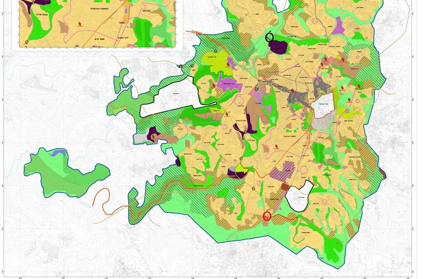
area from Ras Al-Amud (see figure no. 1).
Figure no. 1: the Jerusalem area divided, fragmented according ethno-national affiliation
and separation from it surrounding
9Khamaisi, R.-sustainable in Jerusalem, 46th ISOCARP Congress 2010, Nairobi, Kenya
Based on the above, it is clear that the Palestinian right to the Holy City underwent a
process of control and restriction until it was substantially truncated. In spite of the Israeli
"unification" attempts following occupation of the Palestinian areas in 1967 and the
annexation of occupied East Jerusalem into the state of Israel, this rhetorical, official,
selective unification on the basis of ethnic affiliation did not realize the right to the city. In
fact, the attempt to annex the area kept it divided and fragmented even though the
physical barriers between the Palestinian and Israeli sections were of abolished
following the city's occupation in 1967. The enforced ethno-national fragmentation
continued and inhibited any free participation pertaining to movement, and settlement
within the city borders, or in the formulation of the urban space (Cohen, 1980).
The First Intifada marked the beginning of developing a spatial separation, which
eventually became military/security closure by means of the wall construction. During
this period, the security and trust space within the city and its surroundings shrank, while
fear space and areas of distrust expanded. The security and trust space shrank to the
level of the neighborhoods, while the fear space included seam areas between the
Palestinian and Israeli neighborhoods. Following the closure, the wall was constructed to
isolate the city from its surroundings and exacerbate the city's fragmentation and division
on ethno/national, demographic and spatial bases.
The Israeli claim concerning providing personal and public security in addition to national
geo-demographic security was a major motivator for constructing and determining the
path of the separation wall, but also undermined the possibility of providing and
developing the right to the city for its citizens and residents, as well as whoever else
claimed that Jerusalem is their city and center. Hence, Palestinian Jerusalemites have
not enjoyed the right to citizenship since Israel's occupation of Jerusalem in 1967 which
led to their absence and exclusion from taking the official collective decision in
formulating and forming the city space and producing Jerusalem's structure and network
in response to their requirements and desires.
The geo-political and ethno-demographic transformations in Jerusalem's reality inhibited
local participation in devising, formulating and shaping the space and its urban network.
Thus the formation of the Jerusalemite space has been imposed on the city from above
(the central authority) in response to geo-political considerations and by means of Israeli
governmental intervention; the role of the citizens/residents in participating in forming the
space has been limited and differs between the Israelis and the Palestinians; Israelis
participate in electing their representatives in the local government and in reviving their
civic society, while the Palestinians refuse to participate in shaping and forming the
space, and even resist the decisions imposed on them. This imposition of decisions
affirms the Israeli rejection of a Palestinian right to the city, which is enforced and
underscored by the wall construction.
The Israel territoriality, which includes land confiscation, shrinks the territorial existence
of the Palestinians in Jerusalem, and separates Palestinians from the surrounding
Palestinian cities and villages in West Bank by physical walls and administrative
regulations based on what Israel claims to be security considerations, created a limited
area where Palestinians are allowed to live and move.
The concept of the "open city", sought by the "Jerusalem sustainability coalition" does
not exist. Today, Palestinians in Jerusalem cannot move freely in the city, and cannot
connect to the surrounding Jerusalem. Palestinian accessibility into and within the city
are limited. Just about ten percent of Jerusalem municipality today is used by the
10Khamaisi, R.-sustainable in Jerusalem, 46th ISOCARP Congress 2010, Nairobi, Kenya
Palestinians, and about eighty percent from the area of Jerusalem allocated for housing,
according to planning, is prohibited to be owned and inhabited by Palestinians
Jerusalemites. This, alongside all the Israeli controlled and managed public space,
excluded Palestinians from participating in shaping and managing this public space.
Ethno-national Demographic-phobia consideration guide planning the city
Aside from territorial conflict, the demographic dimension has direct impact on city
planning considerations. The planning policy is to shrink and limit the Palestinian
population in Jerusalem. In 1967, the Israeli government drew the border of the city
considering maximum territory annexed with minimum Palestinian residents. Therefore,
after the war and occupation in 1967, Israel annexed about 70,500 dunums from the
occupied Palestinian territories to West Jerusalem totaling in 38,100 dunums of
municipal areas. This means, an additional approximation of 62 percent increase to the
municipal area which, today, is about 126 thousand dunums.
The Palestinian population in the annexed area was about 68 thousand persons (see
table 1 below). Since 1967, the government of Israel has adopted a policy of ensuring a
"demographic balance". The purpose is ensuring Palestinian minority in Jerusalem no
larger than one-third of the city's inhabitants. The formula of 30% Palestinians versus
70% Israelis has guided the spatial planning policy, the housing policy, the political
arrangements and the outlining of the city limits (Khamaisi, 2006; Khamaisi & Nasrallah,
2006; Margalit, 2006, Shrgay 2010). The concept of "demographic balance" is
misleading, as it implies a neutral policy intended to preserve the balance between the
two populations in the city. In fact, as mentioned, it is intended to preserve the
demographic supremacy of the Jewish population of the city (B'tselem, 1995), and thus
contradicts the principles of the idea of the right to the city, by not entitling all of the
inhabitants of the city to participation in and appropriation of the city.
The adoption of the principle of "preserving the demographic balance in the city"
constitutes one of the central aims of the new outline plan for Jerusalem known as
"Jerusalem 2000", whose objectives are projected to be fulfilled by 2020, and which
include, for the first time, West and East Jerusalem (Jerusalem Local Outline plan 2000;
Report no. 2, Current Status Survey and Analysis of Trends, June 2002, p. 26). This
demographic objective and principle is derived from the grand objective of the outline
plan, which is "establishing the status and continued development of the city as the
capital of the State of Israel, as a center for the Jewish people, and as a city holy to the
three monotheistic religions." The "Jerusalem 2000" outline plan states that a
demographic balance "according to government decision" is the objective presented by
the municipality and adopted in government meetings (950,000 residents), preserving
the ratio of 70% Jews versus 30% Arabs (Jerusalem Outline plan 2000: Report 4,
chapter 7: 202). The planners, after presenting a demographic analysis based on
existing trends and forecasts regarding the city, determine that "it is very reasonable to
assume that if the demographic trends of recent years continue without substantial
change, the situation in 2020 will be one of approximately 60% of the general population
living in the Jewish areas and approximately 40% living in the Arab areas.
11Khamaisi, R.-sustainable in Jerusalem, 46th ISOCARP Congress 2010, Nairobi, Kenya
(in thousands and in percents)
Population
increase
Population 1967 2002 2020 between
2002-2020
Jews 197,700 458,600 570,000 111,400
(74.2%) (67.4%) (24.3%)
(60%)
Arabs 68,600 221,800 380,000 158,200
(25.8%) (32.6%) (71.3%)
(40%)
Total 266,300 680,000 950,000 269,600
(100%) (100%) (100%) (39.6%)
Table no. 1: Distribution of the Demographic Balance between Jews and Arabs in
Jerusalem in 1967 & 2002, and Forecast for 2020
Source: based on the Jerusalem 2000 Outline plan, report no. 4, p. 202, 1967 data,
Central Bureau of Statistics.
In order to cope with that forecast, the planners propose enlarging the Jewish
population, concluding:
"The discussion above leads to the following conclusion: the demographic
trends predicted in the various scenarios for 2020 are fundamentally
affected by the layout of political, economic, social, and cultural forces,
as they have been expressed in practice over the recent years. In order
to prevent the occurrence of those scenarios, or worse ones, far-
reaching changes are needed in the way of dealing with the central
variables affecting the immigration/emigration balances and the gaps in
birth rates, which ultimately create the demographic balance. Those
variables include many subjects regarding personal security,
employment, housing, education, the quality of the environment,
cultural and social life, municipal services, et al. Due to the sensitive
and special situation of Jerusalem, the ability to affect the variables is
in the hands of the Government of Israel (ibid: 2004; emphasis in original).
The planners of the outline plan were aware of the connection between the borders of
the city and the preservation of the demographic balance:
"The Municipal Borders – the forecast relates to the city limits as they are.
Future changes in the city limits can affect the demographic balance if other
municipalities or other undeveloped territory are added to the territory of the
city, or if territory is removed from the city's municipal territory" (ibid: 201).
Examination of the route of the wall constructed around Jerusalem shows that it will
include undeveloped territory, remove neighborhoods inhabited by Palestinians, add
urban Jewish settlements such as Ma'aleh Edumim in the east and Giv'at Ze'ev in the
northwest, and create Palestinian enclaves, such as the Bir Nabala enclave and the
12Khamaisi, R.-sustainable in Jerusalem, 46th ISOCARP Congress 2010, Nairobi, Kenya
Anata enclave. This route for the wall was approved by the government against the
opinion of the inhabitants of the city, especially the Palestinians, and thus their basic
right to participate in creating their urban space was denied them. In fact, inspection of
the path of the separation wall between Jerusalem and its Palestinians hinterland
reveals that ethno-demographic considerations and the residents' housing locations in
accordance with national affiliations represented a basic tenet in charting the wall route.
Residency and the “Center of Life” Policy
Israel used the 1952 Law of Entry to Israel and the 1974 Entry to Israel Regulations as
“legal” instruments to control the number of Palestinians who reside in the city. This was
done through implementing what is called the “Center of Life policy.” Under this policy,
anyone is subject to losing his or her right to live in Jerusalem if he or she cannot prove
that municipal Jerusalem is his or her “center of life.” That is, every Palestinian resident
must pay residence taxes, amongst other taxes, and prove that he/she works and lives
within the municipal boundaries and sends their children to schools inside Jerusalem in
order to prove that Jerusalem is their ‘center of life’. The status of resident of Jerusalem
provides certain social net and entitlement benefits including health insurance and the
welfare system.
Prior to 1996 (the year of approval of the law of “Jerusalem as a Center of Life” in the
Israeli Knesset), this policy only affected Palestinians who had lived abroad for more
than seven years. However, since 1996, it applies just as well to Palestinians who live
outside of the Jerusalem municipal boundaries, encompassing those who live in the
suburbs of Jerusalem and within the West Bank. Palestinians from East Jerusalem live
in these suburbs because of the attractiveness of the availability of land and housing,
lower taxes and fewer building restrictions.
Thus, following the promulgation of the above-mentioned law, many Palestinian
Jerusalemites who had moved to suburbs and Palestinian cities in the West Bank, lost
their right of residence in the city. Since 1967, over 10,000 Palestinians have had their
right to reside in East Jerusalem revoked. This has caused thousands of Palestinians,
who were unwilling to lose their residency rights, to panic and return to living within the
municipal boundaries of East Jerusalem. This has increased neighborhood densities,
because many of these Palestinians returned to live with relatives in the same house, or
were forced to live in hastily constructed houses without obtaining the required building
permits, a process which would have required too much time and money. In 2003 alone,
272 people had their “legal” right to reside in Jerusalem revoked, and 16 in 2004.
Another “legal” policy, which is also meant to control the demographic balance for the
benefit of Jewish superiority, is the Israeli government’s decision to put a halt to the
process of all “family unification” applications submitted by non-resident spouses in May
2002. In July 2003, the Knesset approved a bill which prevents Palestinians who marry
Israeli citizens or Israeli residents from receiving Israeli permanent residency status or
citizenship. This new law will turn many Palestinians living in the city with their families
into illegal residents. As a consequence, they will be subject to arrest and many may be
deported from the city to the West Bank areas.
This demographic and spatial policy is reflected in the spatial planning policy, land
designation, and allocation of land for housing (Bimkom, 2006). Marom (2004), who
discussed the planning "trap" in East Jerusalem, as expressed in planning policy, land
settlement, building permits, and house demolition, stated:
13Khamaisi, R.-sustainable in Jerusalem, 46th ISOCARP Congress 2010, Nairobi, Kenya
"The attempt to preserve the 'demographic balance' amidst the faster
natural growth of the Palestinian population violates accepted planning
considerations and distorts them. The 'demographic balance' leads, de
facto, to restrictions on building for the Palestinian inhabitants of East
Jerusalem" (Marom, 2004: 19; emphasis in original).
The local planning outline plan for the Palestinian neighborhoods, as a program, is
derived from the principle of preserving the "demographic balance". Thus, the scope of
territory allocated for the development of housing, public buildings, and for economic use
is limited, and no larger than 7.1 percent of the area of municipal jurisdiction, which is
12.7 percent of the area of East Jerusalem, despite the fact that the population there
constitutes approximately 36 percent of the inhabitants of the city (Khamaisi, 2006). In
addition, despite the fact that Jerusalem is a city, and that the Palestinian population is
supposed to be urban in its patterns of behavior (its housing patterns, building rights,
and planning direction in the approved outline plans), the Jerusalem 2000 plan actually
preserves their rural configuration. Its objectives, therefore, are territorial and
demographic, not functional. It appears from analysis of the housing plan for the
Palestinians population that the plan proposes one central tool for solving housing
needs: increased density in existing neighborhoods. The data in report No. 4 of the
Jerusalem 2000 outline plan shows that for the Jewish population, the outline plan
allows for the allocation of 47,000 housing units (real capacity, Report No. 4: 137) and
9,500 dunums for development, whereas for the Arab population the plan allocates
26,000 housing units (real capacity for densification of neighborhoods according to table
No. 1, Report No. 4: 139) and approximately 2,300 dunums for development. The
inequality is also manifested in comparing the allocation of building rights in Jewish
neighborhoods and adjacent Palestinian neighborhoods. The policy of increased density,
intended to limit the area designated for Palestinian development, which is also the
declared municipal and government policy toward the Palestinian neighborhoods in East
Jerusalem, contradicts the planners' claim regarding the preservation of the present
character of the city. In addition, there is no real possibility of densification in most of the
areas in which Palestinian inhabitants live due to the limitations on building rights,
building height, and the scarcity of public land (for public buildings and streets),
restrictions on private ownership of land and complicated arrangements regarding proof-
of-ownership. All the outline plans, including the “Jerusalem 2000” outline plan, have
been forced top-down with little participation on the part of the inhabitants, and without
adaptation to current socio-cultural and sociopolitical circumstances.
This outline plan “Jerusalem 2000” is the first statutory plan which deals with the city as
a single unit since 1949. The main goal of the plan, as stated in its report, is “to introduce
new modes of thought in planning and an inclusive plan which aims to continue
developing Jerusalem as the capital of Israel and as a metropolitan center for the benefit
of its residents and their quality of life.”
While the outline plan does not provide for the allocation of lands or the possibility of
creating new neighborhoods for the Palestinians, the detailed plan for the Old City states
that new neighborhoods will be built if residents are forced to relocate. The detailed plan
also articulates the goal of ending the demographic crowding in the Old City, which is
mainly Palestinian, and discusses developing planning tools for the renovation of Old
City residential areas, raising them to sufficient standards. In addition, the plan refers to
the need to assemble an administrative organization to enforce rules and regulations in
the Old City.
14Khamaisi, R.-sustainable in Jerusalem, 46th ISOCARP Congress 2010, Nairobi, Kenya
Despite the major effect of the wall on the Palestinians, and the cutting off of some
neighborhoods from the city and from the West Bank, the plan totally ignores the
existence of the separation wall and its social and economic impact on the city and its
surroundings.
Demographic consideration is part of sustainable consideration. But in the case of
Jerusalem, the relation to demography is considered selectively and according to ethno-
national affiliation. The governmental and municipal planning and development is
directed at attracting more Israeli Jews to city, and the opposite policy towards the
growth of the Palestinians. The creeping "transfer" of the residency among Palestinians
through the prohibited family unification, implementing the center of life policy, limitation
on allocation of planed land for housing, and promoting urbanization among the rural
Palestinians in Jerusalem. All such activities and policies are not an output of
sustainable consideration, but of Israeli demographic-phobia which dictates overthrowing
the issue of planning in order to maintain a Palestinian minority under "Demographic
balance". This situation contributed to un-sustainable planning and development in
Jerusalem.
The Effect of the separation Wall on sustainable planning and development in
Jerusalem
The wall has serious demographic, social and economic ramifications that will seriously
impact East Jerusalem and its hinterland. The urban space of the city will also be
severely affected. In reality, for the Palestinians, Jerusalem is no longer the center of the
West Bank; it has become an isolated peripheral city and its neighborhoods have been
fragmented by a physical barrier and internally divided along national/ethnic, economic
and social group lines. The wall is a unilaterally imposed spatial regime which will
(Khamaisi, 2007):
1. Disrupt East Jerusalem's role as the hub linking the northern and southern West
Bank, transforming the city from a service, commercial, social, and religious
center of the West Bank and Gaza into an isolated enclave cut off from the entire
Palestinian territories.
2. Create more “facts on the ground”; in this instance, it will change the municipal
boundaries of the city by excluding Palestinian neighborhoods and by annexing,
to West Jerusalem, lands of Israeli settlements east, northwest, northeast and
southwest of the city. All in all, the wall will annex an area of more than 164
square kilometers to Jewish metropolitan Jerusalem. It will strengthen the Israeli
continuity at the expense of East Jerusalem's integrity.
3. Change the demographic balance of the population by excluding Palestinian
demographic concentrations: 55,000 Palestinian East Jerusalem residents
effectively will be removed from the city. More than 130,000 Palestinians living in
East Jerusalem suburbs and villages within the Jerusalem Governorate will be
directly affected.
4. Separate East Jerusalem from its hinterland, restricting its natural development
and its relationship to surrounding satellite cities and villages. Bethlehem is the
clearest example of a city cut from its "mother city", and has suffered badly.
Bethlehem relied on East Jerusalem services and its economy was totally
dependent on East Jerusalem.
15Khamaisi, R.-sustainable in Jerusalem, 46th ISOCARP Congress 2010, Nairobi, Kenya
5. Cause real harm to the economy and the role of the secondary commercial and
industrial centers in the Jerusalem suburbs (such as Eizariya, Bir Nabala and Ar
Ram) by isolating them from their center city.
6. Divide families on both sides of the wall. This, obviously, will seriously impact the
social life and the family ties between Palestinians who live on different sides of
the wall, and also those who live in one of East Jerusalem internal enclaves such
as Shu’fat Refugee Camp.
7. Cause severe deterioration in East Jerusalem’s economy by isolating it from its
supporting surroundings and by denying access and limiting mobility of people
and goods. The wall clearly affects trade and the ability of the city to create an
image or conditions that will attract tourists or investors. Ultimately the failed
economy will exhaust the residential population and lead to eventual emigration
that will constitute soft ethnic cleansing.
8. Cause security threats to the Palestinians in residential areas close to the barriers.
9. Reduce the possibility of the birth of a viable and capable Palestinian state
enjoying geopolitical contiguity with East Jerusalem as its capital.
The outline plan Jerusalem 2000 and sustainability of the city
The Jerusalem municipality and government of Israel developed the outline plan despite
the geo-political conflict over Jerusalem as a plan that constitutes principles and
guidelines of sustainability. Our claim is countered through the notion that the plan
continues the situation of un-sustainable development in relevance to the Palestinians.
The plan:
• is the first Plan since the last approved plan (number 62) in 1959. (There has
been separate Town Plan Schemes but never an overall integrated Plan). The
new plan imposed the "unification" of the two part of the city, and try to get
legitimacy to occupation to Eat Jerusalem from Israeli viewpoint, which refused
by the Palestinians and most of the international community.
• is based on the strategies of the TAMA 35 Plan, the Israeli “national” plan that
the government approved in Dec 2005. The goals of this plan regarding
Jerusalem are: 1. Deepening and increasing the Israeli Control over Jerusalem
as the capital of Israel.2. Enforcing Jerusalem as a JEWISH City. 3. Maintaining
a Jewish majority in the City.
• assumes that Jerusalem within the municipal boundaries is one urban unit under
Israeli sovereignty.
• totally ignores the Wall and does not deal with it although it is a main affect on
the Palestinian lives in the city.
• is a strategic statutory plan (outline plan for zoning) and still needs sectorial
detailed plans.
• does not take into consideration the Palestinian migration and panic return into
the city.
16Khamaisi, R.-sustainable in Jerusalem, 46th ISOCARP Congress 2010, Nairobi, Kenya
• was completed in August 2004, but is not yet approved and has no statutory or
legal status
The Mission Statement of this outline plan is "the preparation of an inclusive Plan with
the aim of developing the city as a capital of Israel and a metropolitan center, provided
that the image of the city and the standard of living of all its resident should be
preserved". This mission is not accepted on the Palestinians and international
community.
An outline plan, such as “Jerusalem 2000” outline plan, is a tool in the hands of the
planning system to allocate resources (land, financing, development opportunities),
translate vision, and strategize geo-political arrangements for policies and mechanisms
to allow or confine development.
In Israel, there are various official institutions involved in the spatial planning and
organization of space. The Israeli planning system considers spatial organization and
redistribution the Jewish population to be part of the national security.
The outline plan “Jerusalem 2000” translates the national and regional strategies and
polices for reaching the Israeli geo-political vision and socio-economic goals alongside
securing belonging and symbolic characters.
The overall objectives of the plan are:
• Strengthening and empowering Jerusalem as a capital of Israel
• Introducing high quality of life, economic stability, social justices, and viable
environmental values
• Creating economic conditions for efficient urban functionality (on the metropolitan
level)
Projected population of the plan can be summarized in the following:
• The population of Jerusalem is currently 730,000. The plan ignores the wall so
the Palestinians excluded by the wall still count in the number).
• The expected population by the year 2020 is 950,000 (Palestinians:38%,
Israelis:62%)
• The total area of Jerusalem is 126,000 dunums (to be expanded to the West)
• The construction capacity in Jerusalem is 131,200 building units on the Jewish
side, and 35,400 on the Palestinian side.
17You can also read