INTEGRATED MONITORING AND ASSESSMENT PROGRAMME OF THE MEDITERRANEAN SEA AND COAST AND RELATED ASSESSMENT CRITERIA 5IMAP6
←
→
Page content transcription
If your browser does not render page correctly, please read the page content below

INTEGRATED MONITORING
AND ASSESSMENT PROGRAMME
     OF THE MEDITERRANEAN
             SEA AND COAST
              AND RELATED
       ASSESSMENT CRITERIA
                    (IMAP)
INTEGRATED MONITORING
AND ASSESSMENT PROGRAMME
     OF THE MEDITERRANEAN
             SEA AND COAST
              AND RELATED
       ASSESSMENT CRITERIA
                    (IMAP)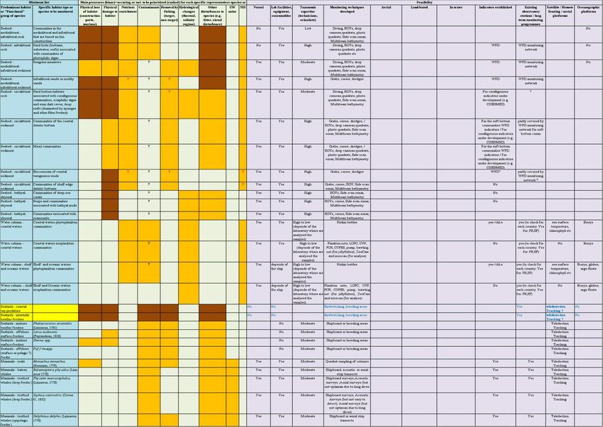
LEGAL NOTICE
The designations employed and the presentation of the material in this document do not imply the expression of any opinion whatsoever
on the part of UNEP/MAP concerning the legal status of any State, Territory, city or area, or of its authorities, or concerning the delimitation
of their frontiers or boundaries.

COPYRIGHT
This publication may be reproduced in whole or in part and in any form for educational or non-profit purposes without special permission
from the copyright holder, provided acknowledgement of the source is made. UNEP/MAP would appreciate receiving a copy of any pu-
blication that uses this publication as a source. This publication cannot be used for resale or for any other commercial purpose whatsoever
without permission in writing from UNEP/MAP.
© 2016 United Nations Environment Programme / Mediterranean Action Plan (UNEP/MAP)
P.O. Box 18019, Athens, Greece

For bibliographic purposes this volume may be cited as:
Integrated Monitoring and Assessment Programme of the Mediterranean Sea and Coast and Related Assessment Criteria
UNEP/MAP Athens, Greece (2016).

UNEP/MAP - United Nation Environment Programme - Mediterranean Action Plan
48, Vassileos Konstantinou Avenue | 11635 Athens | Greece
www.unepmap.org

Graphic layout and production
Final layout and production were prepared by Elena Porrazzo, INFO/RAC - Information and Communication Regional Activity Centre
www.info-rac.org

Photograps by Elena Porrazzo, 2016

This publication is funded by the European Union

The views expressed in this publication do not necessarily reflect the views of the European Commission

UNEP/MAP Information office
Mrs. Hoda Elturk
UNEP/MAP
48, Vassileos Konstantinou Avenue | 11635 Athens | Greece
Tel.: +30 210 7273100 | Fax: +30 210 7253196

UNEP/MAP, Official document series 1/2016
ISBN 978-92-807-3592-5

July 2016

INTEGRATED MONITORING AND ASSESSMENT PROGRAMME
OF THE MEDITERRANEAN SEA AND COAST
AND RELATED ASSESSMENT CRITERIA (IMAP)

TABLE OF CONTENTS

FOREWORD                                                                          2
I. Introduction                                                                  3
II. IMAP common principles and structure                                         3
1. Overarching principles and the overall IMAP structure                         3
2. IMAP integrated monitoring                                                    4
3. IMAP integrated assessment                                                    4
4. UNEP/MAP Strategy towards an Integrated Data and Information System            5
5. Cooperation with other relevant regional bodies in the context of IMAP         5
III. Key elements of IMAP                                                         6
1. Common Indicators                                                              6
2. Monitoring and assessment of biodiversity and NIS related common indicators    7
3. Monitoring and assessment of pollution and litter related common indicators    9
4. Monitoring and assessment of coastal ecosystems
  and landscapes and hydrography related common indicators                       12
5. Monitoring Ecological Objective 11: Energy including underwater noise         13
Annex 1 Reference list of species and habitats                                   15
Annex 2 Pollution/Litter related Assessment Criteria                             23
Following the approval of this ambitious framework for the integrated
FOREWORD monitoring and assessment in the Mediterranean at COP 19, the ini-
tial implementation phase starts in 2016 through a number of steps
By Gaetano Leone, that are expected to cover the next 3 years, i.e.:
Coordinator of the Mediterranean Action Plan · supporting the integration process at national level (review of coun-
try level existing national monitoring and assessment programmes
At their 19th Ordinary Meeting (COP 19, Athens, Greece, 9-12 February in line with IMAP principles, common indicators);
2016), the Contracting Parties to the Convention for the Protection · updating GES definitions and further refining the assessment criteria;
of the Marine Environment and the Coastal Region of the Mediter- · developing a Quality Status Report at regional level in 2017.
ranean (Barcelona Convention) - namely 21 Mediterranean countries
and the European Union - adopted a novel and ambitious Integrated The action and the goals ahead of us to make IMAP a reality will re-
Monitoring and Assessment Programme and related Assessment Cri- quire the full commitment of the Contracting Parties to implement
teria (IMAP). the new monitoring and assessment scheme at the country level, as
well as country capacity assistance and training to be provided by
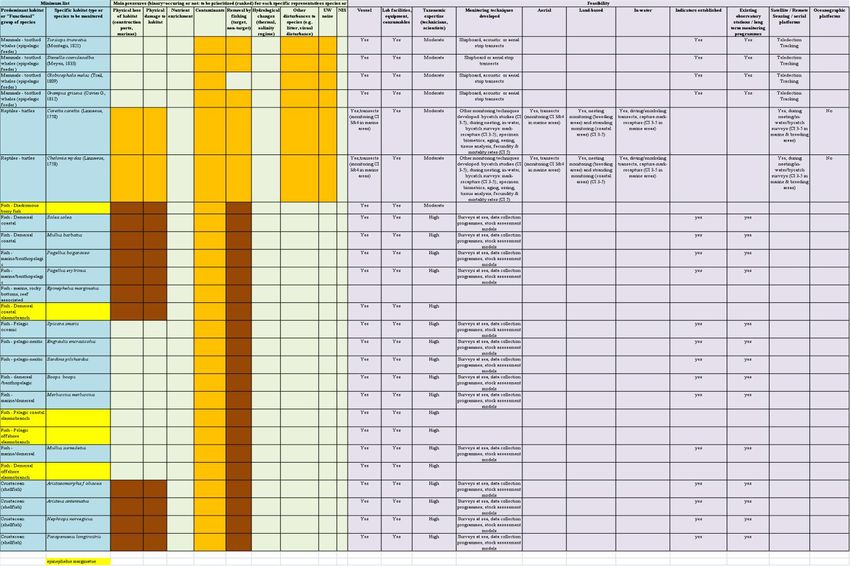
IMAP is a key achievement for the Mediterranean region, which will UNEP/MAP in response to IMAP implementation needs.
enable for the first time a quantitative, integrated analysis of the state
of the marine and coastal environment, covering pollution and ma- Furthermore, a successful IMAP implementation will also rely on the
rine litter, biodiversity, non-indigenous species, coast, and hydrogra- application of Shared Environmental Information System (SEIS) prin-
phy, based on common regional indicators, targets and Good ciples, both at national and regional level, and on the development
Environmental Status (GES) descriptions. of an IMAP-compatible Integrated Data and Information System wi-
thin UNEP/MAP. Equally important will be the further cooperation
IMAP describes the strategy, themes, and products that the Barcelona between countries, but also at regional level, with key partners such
Convention Contracting Parties are aiming to deliver, through colla- as the General Fisheries Commission for the Mediterranean (GFCM)
borative efforts in the framework of the MAP Barcelona Convention, and the Secretariat of the Agreement on the Conservation of Ceta-
during the second cycle of the implementation of the Ecosystem Ap- ceans of the Black Sea, Mediterranean Sea and contiguous Atlantic
proach Process in 2016-2021. The ultimate goal is to assess the status area (ACCOBAMS).
of the Mediterranean sea and coast, as a basis for enhanced action.
The 2030 Agenda for Sustainable Development acknowledges the
IMAP and the common indicators that are its backbone are the out- importance of the regional and sub-regional dimensions, regional
come of the Ecosystem Approach Process The Ecosystem Approach economic integration and interconnectivity in sustainable develop-
process was specified at the 15th Meeting of the Contracting Parties ment. Regional and sub-regional frameworks are recognised as faci-
to the Barcelona Convention, in Decision IG. 17/6, with the vision of litating the effective translation of sustainable development policies
“A healthy Mediterranean with marine and coastal ecosystems that intro concrete action at the national level. Regional Sea Programmes
are productive and biologically diverse for the benefit of present and have an important role to play in this sense with their mandates,
future generations” and an Ecosystem Approach Roadmap, aiming structures and partnerships. The UNEP/MAP Barcelona Convention
to achieve this vision., and the coordinated efforts of the Contracting own instruments and activities are, therefore, relevant not only for
Parties at all levels. In line with the Ecosystem Approach Process as the achievement of GES but also for the implementation of the 2030
early as 2008, the Contracting Parties to the Barcelona Convention Agenda and the SDGs. In this context, IMAP is an initiative that will
agreed to undertake the following key steps: contribute to the regional follow-up, and measuring of achievement
• Definition of an Ecological Vision for the Mediterranean; of the relevant SDGs and associated targets.
• Setting of common Mediterranean strategic goals;
• Identification of important ecosystem properties and assessment At UNEP/MAP, we firmly believe that the agreement on IMAP is a mi-
of ecological status and pressures; lestone in the successful history of the MAP-Barcelona Convention.
• Development of a set of ecological objectives corresponding to the It provides the basis for a solid assessment of the Good Environmen-
Vision and strategic goals; tal Status of the Mediterranean, and it shows again the commitment
• Derivation of operational objectives with indicators and target le- of all Contracting Parties to the protection of the environment of the
vels; “Mare Nostrum” through cooperation and dialogue.
• Revision of existing monitoring programmes for ongoing asses- We are ready to meet the challenges of the IMAP initial implemen-
sment and regular updating of targets; tation phase, driven by our common vision: “A healthy Mediterranean
• Development and review of relevant action plans and programmes. with marine and coastal ecosystems that are productive and biolo-
Subsequently, the Parties agreed on strategic goals to achieve the gically diverse for the benefit of present and future generations”.
Ecosystem Approach vision, on 11 Ecological Objectives, and on mat-
ching Good Environmental Status descriptions, targets and indicators.
1. The Ecosystem Approach process was specified at the 15th Meeting of the
Contracting Parties to the Barcelona Convention, in Decision IG. 17/6, with the vision
2 of “A healthy Mediterranean with marine and coastal ecosystems that are productive
and biologically diverse for the benefit of present and future generations” and an
Ecosystem Approach Roadmap, aiming to achieve this vision.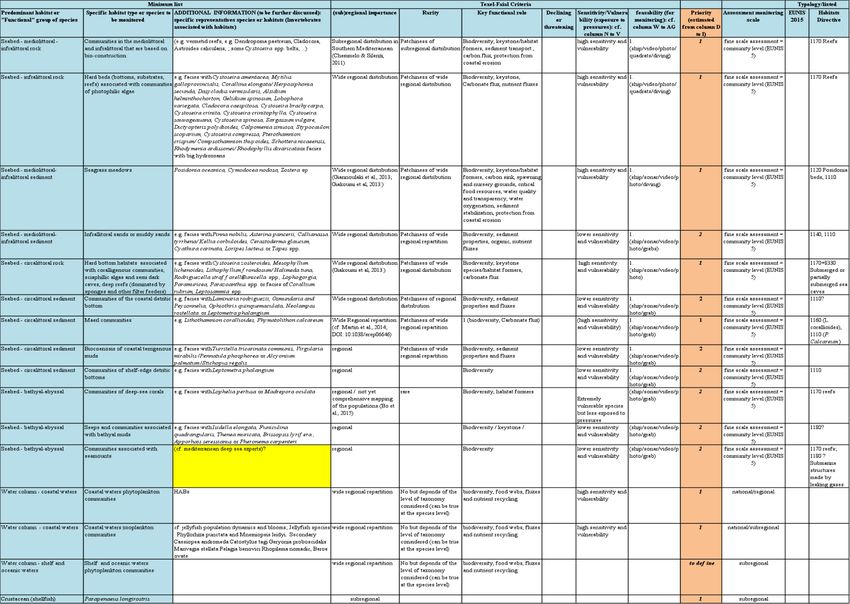
INTEGRATED MONITORING                                                 programmes will be integrated, in line with the IMAP structure
AND ASSESSMENT                                                        and principles and based on the agreed common indicators. This
PROGRAMME                                                             implies in practice that the existing national monitoring and
OF THE MEDITERRANEAN                                                  assessment programmes will be reviewed and revised as
SEA AND COAST                                                         appropriate so that national implementation of IMAP can be
AND RELATED ASSESSMENT                                                fulfilled in a sufficient manner.
CRITERIA
                                                                      The main outputs during the initial phase of IMAP will include
I. INTRODUCTION                                                       the update of GES definitions, further refinement of assessment
                                                                      criteria and development of national level integrated monitoring
1. Monitoring and assessment, based on scientific knowledge,          and assessment programmes.
of the sea and coast is the indispensable basis for the
management of human activities, in view of promoting                  5. Furthermore, the Quality Status Report in 2017 and the State
sustainable use of the seas and coasts and conserving marine          of Environment and Development Report in 2019 will build on
ecosystems and their sustainable development. The Integrated          the structure, objectives and data collected under IMAP.
Monitoring and Assessment Programme of the Mediterranean
Sea and Coast and Related Assessment Criteria (IMAP) describes        The validity of the IMAP should be reviewed once at the end of
the strategy, themes, and products that the Barcelona                 every EcAp six year cycle, and in addition it should be updated
Convention Contracting Parties are aiming to deliver, through         and revised as necessary on a biennial basis, based on lessons
collaborative efforts inside the UNEP/MAP Barcelona Convention,       learnt of the implementation of the IMAP and on new scientific
over the second cycle of the implementation of the Ecosystem          and policy developments.
Approach Process (EcAp process), i.e. over 2016-2021, in order
to assess the status of the Mediterranean sea and coast, as a         II. IMAP COMMON PRINCIPLES
basis for further and/or strengthened measures.                       AND STRUCTURE
                                                                      1. Overarching principles and the overall IMAP
Background                                                            structure
2. IMAP builds on the monitoring and assessment related               6. The overarching principles guiding the development of the
provisions of the Barcelona Convention and its Protocols, previous    IMAP include (i) adequacy; (ii) coordination and coherence; (iii)
Decisions of the Contracting Parties related to monitoring and        data architecture and interoperability based on common
assessment, and to the EcAp process, including on Decision IG.        parameters; (iv) concept of adaptive monitoring; (v) risk-based
21/3 and the expert level discussions mobilized based on this         approach to monitoring and assessment, and (v) the
Decision, such as the ones taking place in the Correspondence         precautionary principle, in addition to the overall aim of
Groups on Good Environmental Status (COR GEST) and Monitoring         integration.
(CORMON), as well as the 4th and 5th EcAp Coordination Group.
                                                                      In line with the above overarching principles, data and
3. In addition, the development of IMAP took due account of           information is gathered through integrated monitoring activities
the Contracting Parties’ existing monitoring and assessment           on the national level and shared in a manner that creates a
programmes, practices of other Regional Sea Conventions and           compatible, shared regional pool of data, usable by each
other Regional bodies.                                                Contracting Party, as described under at point 4.

Timeline                                                              7. The IMAP information system will ensure the establishment
                                                                      of the regional pool of data based on SEIS principles that will
4. IMAP is aiming to deliver over 2016-2021 its objectives as         allow the production of common indicator assessment reports
described above. It is introduced first however in an initial phase   in an integrated manner, following the monitoring specifics and
(in line with Decision IG. 21/3, in between 2016-2019), during        data provided, which ensures comparability across the
which the existing national monitoring and assessment                 Mediterranean region.

                                                                INTEGRATED MONITORING AND ASSESSMENT PROGRAMME
                                                OF THE MEDITERRANEAN SEA AND COAST AND RELATED ASSESSMENT CRITERIA                   3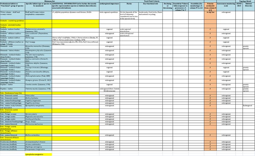
8. In line with the above, integration is achieved through IMAP    stations and activities, information, and data could be steps
both at monitoring level, through an integrated monitoring         towards this direction.
system, following common principles and undertaken in a
coordinated manner and at assessment level, with the overall       3. IMAP integrated assessment
aim to assess the overall status of the marine and coastal
environment.                                                       13. The IMAP assessment products, produced by the UNAP/MAP
                                                                   Secretariat, including the Common Indicator Assessment Fact
2. IMAP integrated monitoring                                      Sheets, and the planned integrated assessments (2017 Status
                                                                   Quality Report, 2019 State of Environment and Development
9. The IMAP monitoring requirements focus on, based on agreed      Report, 2023 State of Environment Report), should be mainly
common indicators, parameters that are indicative of the state     based on the common indicators and monitoring data provided
of the environment, the prevailing anthropogenic pressures and     by Contracting Parties.
their impacts, and the progress towards the good environmental
status (ecological objectives and targets). The monitoring is      14. In areas of scientific and/or data gaps, the assessment
carried out in such a way that an assessment with adequate         products can also build on relevant scientific projects, pilot
confidence and precision is achieved.                              outcomes, and comparable data of other regional organizations
                                                                   and in case these are not available, on scientific literature. In
10. The IMAP sets out the basis for how the Contracting Parties    addition, they will analyze trends, drivers and will build on
should design and carry out their national integrated monitoring   available socio-economic data.
programmes and work together in the framework of the
UNEP/MAP Barcelona Convention to produce and update                15. The common indicator assessment fact sheets provide
common indicator based regional assessments on the status of       information on the status of the environment and information
the Mediterranean Sea and coast.                                   needed to evaluate the severity of environmental problems and
                                                                   distance from EcAp targets, ecological objectives and Good
11. During the initial phase of IMAP (2016-2019), Contracting      Environmental Status (GES) description.
Parties will:
                                                                   The common indicator assessment fact sheets are linked to
• During 2016-2017, update their existing monitoring               specific Ecological Objectives (EOs) and together they indicate
 programmes in order to cover the IMAP areas, common               whether the GES related to the specific EO is met or not.
 indicators in line with the IMAP, and, based on the Integrated    Following the EO level assessment, the integrated assessment
 Monitoring and Assessment Guidance, Common Indicator Fact         takes place on the state of the Mediterranean Sea and Coast.
 Sheets. It has to be noted that a number of Contracting Partied
 have already developed integrated national monitoring             16. The 2017 Status Quality Report will be based on the common
 programmes;                                                       indicators, and common indicator assessment fact sheets
                                                                   established for them, following a model to be developed by the
• Continue reporting based on their existing national monitoring   Secretariat in cooperation with the Contracting Parties through
  programmes until they are updated into a national Integrated     CORMONs by the end of 2016, and will consider the data from
  Monitoring Programme;                                            the most recent national monitoring and relevant scientific
                                                                   projects and pilots undertaken relevant to the IMAP.
• Following the update of their existing monitoring programmes,
  report quality assured data following a common regional          17. During the development of the above an integrated
  monitoring reporting template (please see more on this under     approach for determining and assessing GES will be used,
  point 4);                                                        considering the Integrated Monitoring and Assessment
                                                                   Guidance, describing state-based common indicators and
12. During national implementation, the Contracting Parties are    explicitly relating them to the pressure-based indicators.
encouraged to coordinate within and between each other in
order to use resources in an efficient way. Shared monitoring

4
4. UNEP/MAP Strategy towards an Integrated                           5. Cooperation with other relevant regional
Data and Information System                                          bodies in the context of IMAP

18. Assessments arising from monitoring data are critically          22. The current IMAP covers with agreed common indicators
dependent upon practical mechanisms for handling data from           the ecological objectives related to biodiversity (EO1), non-
different activities that ensure that documents, data, and           indigenous species (EO2), eutrophication (EO5), hydrography
products are managed consistently and are easily available to        (EO7), coast (EO8), contaminants (EO9), and marine litter (EO10).
users. This will support integrated assessments, for example from
integrated biological and chemical programmes, or linking the        23. In addition, regarding marine noise (EO11), IMAP includes
observed changes in spatial distribution and temporal trends in      candidate common indicators, with the intention for these
substances or their effects to inputs into the UNEP/MAP              candidate common indicators to be further developed, based
Barcelona Convention maritime area.                                  on pilot monitoring activities, additional expert knowledge, and
                                                                     scientific developments, during the initial phase of IMAP.
19. Data storage and handling processes are therefore central,
and it is important that the role of the various components in       24. While some of the elements of fisheries (EO3) and marine
this is clear and continuously developed and strengthened.           food webs (EO4) are partly covered by the monitoring and
                                                                     assessment of EO1 and EO2 and the Contracting Parties have
20. The IMAP thus requires an updated and integrated data            agreed on the GFCM developed list of common indicators, the
and information system for UNEP/MAP Barcelona Convention             monitoring and assessment specifics of EO3 are still being
with clear set roles for data handling and assessment for the        developed by the GFCM, in close cooperation with UNEP/MAP.
various components and with a user-friendly reporting platform       During the initial phase of IMAP implementation, a clear
for Contracting Parties, based on the following strategic points:    roadmap will be developed by the Secretariat in collaboration
                                                                     with GFCM and other relevant partners on the monitoring
• The UNEP/MAP Barcelona Convention data and information             programme and assessment for EO4 and EO6.
  activities aim to achieve a reliable, quantitative assessment of
  the status of the Mediterranean Sea and Coast;                     25. In light of the above, it is an absolute necessity for
                                                                     UNEP/MAP to strengthen its cooperation with the relevant
• The UNEP/MAP Barcelona Convention data and information             regional bodies, especially in relation to:
  activities should facilitate access and knowledge of the general
  public to environmental information.                               • EO1, both with the General Fisheries Commission for the
                                                                       Mediterranean (GFCM) for commercial species of fish and
21. Basic activities, core elements of the UNEP/MAP Barcelona          shellfish and the Secretariat of the Agreement on the
Convention integrated data and information system should include:      Conservation of Cetaceans of the Black Sea, Mediterranean Sea
                                                                       and contiguous Atlantic area (ACCOBAMS), noting that the
• Based on the structure of the Common Indicator Fact Sheets,          ACCOBAMS Survey Initiative, to be undertaken during 2016-
  develop region-wide, electronic, common indicator based              2019, will provide important inputs (in terms of monitoring
  monitoring reporting formats and up-to-date tools for data           methodologies, capacity building and reliable data on
  exchange;                                                            abundance and distribution of cetaceans);

• implement relevant quality control and validation procedures;      • EO3, with the GFCM, noting that the EO3 related common
                                                                       indicators will be further developed and assessed by GFCM
• make assessment products available in an integrated manner,          (with assessment results provided to UNEP/MAP in order to
  on a common platform;                                                undertake the 2017 and following integrated assessments);

• make data and information available using harmonized               • EO11, with ACCOBAMS, noting that further development of the
  standards and practices, following the UNEP access-to-               candidate common indicators will need to be carried out in a
  information policy (UNEP/EA. 1/INF/23).                              close cooperation between UNEP/MAP and ACCOBAMS in light

                                                               INTEGRATED MONITORING AND ASSESSMENT PROGRAMME
                                               OF THE MEDITERRANEAN SEA AND COAST AND RELATED ASSESSMENT CRITERIA                   5
of pilot monitoring activities, additional expert knowledge, and    3. Species distributional range (EO1 related to marine mammals,
 scientific developments, during the initial phase of IMAP, and      seabirds, marine reptiles);
 considering that ACCOBAMS is undertaking an identification          4. Population abundance of selected species (EO1, related to ma-
 of noise hot spots in the Mediterranean.                            rine mammals, seabirds, marine reptiles);
                                                                     5. Population demographic characteristics (EO1, e.g. body size
26. In addition, cooperation with other regional and international   or age class structure, sex ratio, fecundity rates, survival/mortality
bodies will be key for the successful implementation of IMAP, to     rates related to marine mammals, seabirds, marine reptiles);
ensure that no double obligation is created for those Contracting    6. Trends in abundance, temporal occurrence, and spatial distri-
Parties, which are Parties to various Regional Seas Conventions      bution of non-indigenous species, particularly invasive, non-in-
and/or members of the European Union and undertake                   digenous species, notably in risk areas (EO2, in relation to the
monitoring activities under other specific frames.                   main vectors and pathways of spreading of such species);
                                                                     7. Spawning stock Biomass (EO3);
27. Cooperation with other regional and international bodies         8. Total landings (EO3);
can also strengthen the cost-efficiency and scientific adequacy      9. Fishing Mortality (EO3);
of IMAP. Exchange of best practices and information is               10. Fishing effort (EO3);
encouraged during the IMAP implementation, both in between           11. Catch per unit of effort (CPUE) or Landing per unit of effort
Contracting Parties participating in various monitoring              (LPUE) as a proxy (EO3);
programmes and in between UNEP/MAP and other relevant                12. Bycatch of vulnerable and non-target species (EO1 and EO3)
regional, international bodies.                                      13. Concentration of key nutrients in water column (EO5);
                                                                     14. Chlorophyll-a concentration in water column (EO5);
III. KEY ELEMENTS OF IMAP                                            15. Location and extent of the habitats impacted directly by hy-
                                                                     drographic alterations (EO7) to also feed the assessment of EO1
1. Common Indicators                                                 on habitat extent;
                                                                     16. Length of coastline subject to physical disturbance due to
28. The common indicators are the backbone of IMAP.                  the influence of man-made structures (EO8) to also feed the as-
                                                                     sessment of EO1 on habitat extent;
29. In the context of the Barcelona Convention, a common             17. Concentration of key harmful contaminants measured in the
indicator is an indicator that summarizes data into a simple,        relevant matrix (EO9, related to biota, sediment, seawater);
standardized, and communicable figure and is ideally applicable      18. Level of pollution effects of key contaminants where a cause
in the whole Mediterranean basin, or at least on the level of sub-   and effect relationship has been established (EO9);
regions, and is monitored by all Contracting Parties. A common       19. Occurrence, origin (where possible), and extent of acute pol-
indicator is able to give an indication of the degree of threat or   lution events (e.g. slicks from oil, oil products and hazardous sub-
change in the marine ecosystem and can deliver valuable              stances) and their impact on biota affected by this pollution (EO9);
information to decision makers.                                      20. Actual levels of contaminants that have been detected and
                                                                     number of contaminants which have exceeded maximum regu-
30. Candidate indicators are indicators which still have many        latory levels in commonly consumed seafood (EO9);
outstanding issues regarding their monitoring and assessment         21. Percentage of intestinal enterococci concentration measure-
and therefore are recommended to be monitored in the initial         ments within established standards (EO9);
phase of IMAP on a pilot and voluntary basis.                        22. Trends in the amount of litter washed ashore and/or depo-
                                                                     sited on coastlines (including analysis of its composition, spatial
The Common and candidate indicators agreed upon, which are           distribution and, where possible, source.) (EO10);
at the core of IMAP, include:                                        23. Trends in the amount of litter in the water column including
                                                                     microplastics and on the seafloor (EO10);
1. Habitat distributional range (EO1) to also consider habitat ex-   24. Candidate Indicator: Trends in the amount of litter ingested
tent as a relevant attribute;                                        by or entangling marine organisms focusing on selected mam-
2. Condition of the habitat’s typical species and communities        mals, marine birds and marine turtles (EO10);
(EO1);                                                               25. Candidate Indicator: Land use change (EO8)

6
26. Candidate indicator: Proportion of days and geographical di- The common indicators to be monitored and assessed in relation
stribution where loud, low, and mid-frequency impulsive sounds to biodiversity are as following:
exceed levels that are likely to entail significant impact on marine COMMON INDICATOR 1: Habitat distributional range (EO1) to
animals (EO11) also consider habitat extent as a relevant attribute;
27. Candidate Indicator: Levels of continuous low frequency COMMON INDICATOR 2: Condition of the habitat’s typical
sounds with the use of models as appropriate (EO11) species and communities (EO1);
COMMON INDICATOR 3: Species distributional range (EO1
31. During the implementation of the initial phase of IMAP, the related to marine mammals, seabirds, marine reptiles);
CORMONs will further develop the candidate indicators towards COMMON INDICATOR 4: Population abundance of selected
common indicators as well as to further refine the specifics of species (EO1, related to marine mammals, seabirds, marine
agreed common indicators, in particular on geographical scale, reptiles);
in light of the ongoing implementation experience of IMAP. COMMON INDICATOR 5: Population demographic
characteristics (EO1, e.g. body size or age class structure, sex
ratio, fecundity rates, survival/mortality rates related to marine
NOTE ON GEOGRAPHIC REPORTING SCALES mammals, seabirds, marine reptiles)
32. A scale of reporting units’ needs to be defined during the 35. As it is not possible or even necessary to monitor all
initial phase of IMAP taking into account both ecological attributes and components of biological diversity throughout
considerations and management purposes, following a nested the region, the IMAP monitoring is focusing, in line with the risk-
approach. based approach, on some representative sites and species, which
can showcase the relationship between environmental pressures
The nested approach aims to accommodate the needs of the and their main impacts on the marine environment.
above is to take into account 4 main reporting scales:
In light of the above, a reference list of species and habitats to
(1) Whole region (i.e. Mediterranean Sea); be monitored is presented in Annex 1, noting that those
(2) Mediterranean sub-regions, as presented in the Initial Contracting Parties who have the necessary means and are
Assessment of the Mediterranean Sea, UNEP(DEPI)/MED willing to do so can go beyond the monitoring requirements of
IG.20/Inf.8; this reference list.
(3) Coastal waters and other marine waters;
(4) Subdivisions of coastal waters provided by Contracting 36. The Contracting Parties while updating their national
Parties monitoring programmes need to include at least the monitoring
of the reference list species and habitats with at least two
33. The work shall be undertaken to further develop reporting monitoring areas, one in a low pressure area (e.g. marine
geographical scales of the nested approach. protected area/ Specially Protected Area of Mediterranean
Importance (SPAMI) and one in a high pressure area from human
2. Monitoring and assessment of biodiversity activity.
and NIS related common indicators
37. The few species of cetaceans regularly present in the
BIODIVERSITY (EO1)
Mediterranean Sea should all be considered when developing
the national monitoring programmes. The Contracting Parties
34. Biological diversity is the “variability among living organisms shall make every effort to identify a minimum of two species to
from all sources, including, inter alia, terrestrial, marine and other be included in their national monitoring programme, based on
aquatic ecosystems and the ecological complexes of which they the specificity of their marine environment and biodiversity, and
are part; this includes diversity within species, between species taking account that these species should belong to at least two
and of ecosystems”. different functional groups, where possible (Baleen whales/Deep-
diving toothed whales/Shallow-diving toothed whales). As far
as possible the choice of monitored species should be
INTEGRATED MONITORING AND ASSESSMENT PROGRAMME
OF THE MEDITERRANEAN SEA AND COAST AND RELATED ASSESSMENT CRITERIA 7coordinated at sub regional scale to ensure coherence with 45. Non-indigenous species monitoring in the Mediterranean
cetacean population distribution in the Mediterranean Sea. is a trend monitoring, where it is key to establish reliable, long-
term data-sets as a first step of monitoring.
38. The methodologies and quality control and quality assurance
measures available for Contracting Parties to consider during the 46. In addition, monitoring of non-indigenous species (NIS),
update of their national monitoring programmes are described following the risk based approach, needs to be focused on the
in the Integrated Monitoring and Assessment Guidance. invasive alien species (IAS) in IAS introduction “hot spots” (e.g.
ports and their surrounding areas, docks, marinas, aquaculture
39. Regarding the assessment of biodiversity, it has to be noted that installations, heated power plant effluents sites, offshore
the quantitative definition of GES is difficult, considering the variety structures). In addition, areas of special interest such as marine
of assessment elements. The conceptual approach for a quantitative protected areas or lagoons may be selected on a case by case
GES setting can be framed in a way that the resilience of the basis, as appropriate, depending on the proximity to alien species
ecosystem is suited to accommodate the quantified biodiversity, or, introduction hot spots.
in other words, it will be accounted in the determination of the GES
boundaries as the “acceptable deviation from a reference state which 47. With the application of the risk based approach as stated
reflects conditions largely free from anthropogenic pressures. above, it is possible to obtain an overview of the non-indigenous
species present at a large spatial scope while only monitoring a
40. The scale of monitoring is of specific importance for biodiversity, relatively small number of locations.
due to the nature of the biodiversity related common indicators.
48. Based on existing regional databases, such as the Marine
41. For the high quality of assessment, baselines and thresholds Mediterranean Invasive Alien Species database, (MAMIAS), the
will need to be agreed on in line with the possible methods for “Andromeda” invasive species database for the Mediterranean
this set out in the Integrated Monitoring and Assessment and Black Sea, and the European Alien Species Information
Guidance document, following the agreed scales of assessment, Network (EASIN), each Contracting Party will determine the list
during the initial phase of IMAP implementation. of IAS to be monitored in its national monitoring programme
during the initial phase of the IMAP and start collecting data
regarding these species. Guidance on developing IAS national
NON-INDIGENOUS SPECIES (EO2) lists and a regional and or sub regional reference list will be
developed by 2017.
42. Non-indigenous species (NIS; synonyms: alien, exotic, non-
native, allochthonous) are species, subspecies, or lower taxa 49. The methodologies and quality control and quality
introduced outside of their natural range (past or present) and assurance measures available for Contracting Parties to consider
outside of their natural dispersal potential. during the update of their national monitoring programmes, is
described in the Integrated Monitoring and Assessment
43. Invasive alien species (IAS) are a subset of established NIS Guidance.
which have spread, are spreading, or have demonstrated their
potential to spread elsewhere, and which have an effect on 50. As the most effective monitoring method a Rapid
biological diversity and ecosystem functioning (by competing Assessment Survey (RAS) will be carried out, at least yearly by
with and on some occasions replacing native species), socio- the Contracting Parties in hot-spot areas (e.g. ports and their
economic values, and/or human health in invaded regions. surrounding areas, docks, marinas, aquaculture installations,
heated power plant effluents sites, offshore structures).
44. The common indicator in relation to NIS is:
COMMON INDICATOR 6: Trends in abundance, temporal 51. In addition, UNEP/MAP will develop during the initial phase
occurrence, and spatial distribution of non-indigenous species, of IMAP citizen survey guidance for NIS, to enable Contracting
particularly invasive, non-indigenous species, notably in risk areas Parties to use this additional cost-efficient methodology, which
(EO2, in relation to the main vectors and pathways of spreading also strengthens public awareness and participation.
of such species in the water column and seabed, as appropriate);
852. Regarding the assessment of EO2, to be able to specify 58. The geographical scale of monitoring for the assessment of
further GES, it is important to understand which NIS are present GES for eutrophication will depend on the hydrological and
within the marine region and sub-regions. A baseline assessment morphological conditions of an area, particularly the freshwater
of the extant NIS would provide a reference point against which inputs from rivers, the salinity, the general circulation, upwelling,
the success of future actions could be measured. After this and stratification.
baseline data has been gathered during the initial phase of IMAP,
it will be possible to set reference levels, following the 59. The spatial distribution of the monitoring stations should
assessment criteria set out in the Integrated Monitoring and thus, prior to the establishment of the eutrophication status of
Assessment Guidance. the marine sub-region/area, be risk-based and proportionate to
the anticipated extent of eutrophication in the sub-region under
3. Monitoring and assessment of pollution consideration as well as its hydrographic characteristics aiming
and litter related common indicators for the determination of spatially homogeneous areas.
Consequently, each Contracting Party would be required to
EUTROPHICATION (EO5)
determine the optimum frequency per year and optimum
locations for their monitoring/sampling stations.
53. Eutrophication is a process driven by enrichment of water by
nutrients, especially compounds of nitrogen and/or phosphorus, 60. It is recommended that the Contracting Parties rely on the
leading to: increased growth, primary production and biomass of classification scheme on chl-a concentration ( g/l) developed
algae; changes in the balance of nutrients causing changes to the by MEDGIG as an assessment method that is easily applicable
balance of organisms; and water quality degradation. by all Mediterranean countries, based on the indicative
thresholds and reference values adopted therein (see Table 2,
54. Eutrophication related common indicators: Annex 2). In this context, water typology is a very important
Common indicators related to eutrophication: factor for the further development of classification schemes in
COMMON INDICATOR 13: Concentration of key nutrients in a certain area regarding the definition of sub-regional
water column (EO5); thresholds for chlorophyll-a.
COMMON INDICATOR 14: Chlorophyll-a concentration in water
column (EO5) 61. In addition, countries, where appropriate may continue using
the existing different eutrophication assessment methods such
55. The monitoring of eutrophication under IMAP builds on the as TRIX, Eutrophication scale, EI, HEAT, etc. at sub-regional or
existing monitoring system of UNEP/MAP MED POL Monitoring national levels for assessing eutrophication trends.
programme, and most of the Contracting Parties already have
monitoring programmes in place for eutrophication all over the 62. The assessment methodology is well described in the
Mediterranean basin, which constitutes a greater concern for the Integrated Monitoring and Assessment Guidance for
Adriatic than for the rest of sub-regions. eutrophication. The final report of the Informal Online working
group on eutrophication (UNEP((DEPI)/MED WG.420/Inf.11)
56. The Contracting Parties, building on their existing national contains assessment criteria regarding eutrophication which are
monitoring programmes and previous MED POL experience on presented in Annex 2 of this document.
eutrophication, will update these programmes during the initial
phase of IMAP, with the overall aim to establish coherent datasets 63. During the initial phase of IMAP implementation, work will
at the entire regional sea level. be undertaken to develop GES thresholds and reference
conditions for nutrients, transparency, and oxygen, using an
57. The methodologies and quality control and quality assurance adequate geographical scale as well as harmonize existing
measures available for Contracting Parties to consider during the assessment tools through workshops, dialogue, comparative
update of their national monitoring programmes are described exercises at regional/sub-regional/subdivision levels.
in the Integrated Monitoring and Assessment Guidance, noting
the differences of needed techniques based on the level of the 64. In addition, taking into account sub-regional differences,
eutrophication problem in different sub-regions and countries. work will be also undertaken to develop assessment fact sheets
INTEGRATED MONITORING AND ASSESSMENT PROGRAMME
OF THE MEDITERRANEAN SEA AND COAST AND RELATED ASSESSMENT CRITERIA 9for eutrophication common indicator based on specifics 68. In addition, important development areas during the initial
described in the Integrated Monitoring and Assessment phase of IMAP will include harmonisation of monitoring targets
Guidance. (determinants and matrices) within assessment sub-regions,
development of suites of assessment criteria, integrated chemical
and biological assessment methods, and review of the scope of
the monitoring programmes to ensure that those contaminants
CONTAMINANTS (EO9)
which are considered to be important within each assessment
area are included in monitoring programmes.
65. The monitoring of concentrations of a range of chemical
contaminants in water, sediments and biota has a long standing 69. Noting the above, the Contracting Parties will update their
history in the Mediterranean, under the auspices of the existing contaminants-related monitoring programmes by
UNEP/MAP Barcelona Convention, its Land-Based Protocol, and building on their existing sampling station networks, existing
UNEP/MAP MED POL monitoring programmes. The IMAP builds methodologies and statistical tools, existing data sets, and
on these existing legislative bases, programmes. existing time series as the basis of monitoring against a “no
deterioration” objective, aiming to cover the monitoring of all
Contaminants related common indicators: contaminants related common indicators.
COMMON INDICATOR 17: Concentration of key harmful
contaminants measured in the relevant matrix (EO9, related to 70. While most monitoring stations already exists, there is also
biota, sediment, seawater); a need for Contracting Parties to include in their monitoring
COMMON INDICATOR 18: Level of pollution effects of key programme areas beyond the coastal areas in a representative
contaminants where a cause and effect relationship has been and efficient way, where risks warrant coverage, in line with the
established (EO9); Integrated Monitoring and Assessment Guidance.
COMMON INDICATOR 19: Occurrence, origin (where possible),
extent of acute pollution events (e.g. slicks from oil, oil 71. The methodologies, quality control and quality assurance
products and hazardous substances), and their impact on measures, and reference methods available for Contracting
biota affected by this pollution (EO9); Parties to consider during the update of their national
COMMON INDICATOR 20: Actual levels of contaminants that monitoring programmes, are described in the Integrated
have been detected and number of contaminants which have Monitoring and Assessment Guidance.
exceeded maximum regulatory levels in commonly consumed
seafood (EO9); 72. Regarding assessment, the Report UNEP(DEPI)MED
COMMON INDICATOR 21: Percentage of intestinal enterococci WG.394/Inf.3 on the development of assessment criteria for
concentration measurements within established standards hazardous substances and the final report of the Informal Online
(EO9) working group on contaminants (UNEP((DEPI)/MED WG.420/Inf.12)
present key recommendations which will be followed to establish
66. All Mediterranean countries have programmes already in a forward procedure for monitoring the achievement of GES for
place in relation to contaminants monitoring, however the scope contaminants during the initial phase of IMAP (Annex 2 of this
and scale of this monitoring varies. The IMAP thus aims to build Annex).
more harmony in between the various existing monitoring
programmes, based on the agreed common indicators. 73. Until EACs are defined under this follow-up, a two-fold
approach could be adopted to support monitoring for the
67. Biological effects monitoring is generally less widely established assessment of GES:
in both national and international programmes, and the number of a) a threshold value for GES(BAC), to be set using
countries undertaking such studies (and the intensity of the concentrations from relatively unpolluted areas on a sub-
coverage) is much smaller. Therefore, it will be essential during the regional level and
initial phase of IMAP to expand and develop further the use of b) a decreasing trend should be observed from baseline
biological effects methods to cover properly the EO9. values representing the actual level of contaminants
concentrations.
1074. Thus, GES can be defined for toxic metals (Hg, Cd, Pb), MARINE LITTER (EO10)
chlorinated organic compounds, and PAHs, for which monitoring
data exist as a result of running monitoring programmes, already 81. Marine litter monitoring of IMAP is based on the Regional
during the initial phase of IMAP, and UNEP/MAP will conclude Plan on Marine Litter management (Decision IG. 20/10, the
its relevant common indicator based assessment in light with MLRP) and on the following agreed common and candidate
the above. indicators:
COMMON INDICATOR 22: Trends in the amount of litter
75. In addition, during the initial phase of IMAP, UNEP/MAP will washed ashore and/or deposited on coastlines (EO10);
also prepare an adapted manual establishing the BAC and, when COMMON INDICATOR 23: Trends in the amount of litter in the
possible, the formulation of EAC for selected biomarkers in water column including microplastics and on the seafloor
Mediterranean species. (EO10);
CANDIDATE INDICATOR 24: Trends in the amount of litter
76. Regarding acute pollution events, while Contracting Parties ingested by or entangling marine organisms focusing on
already have an existing monitoring obligation under Article 9 selected mammals, marine birds, and marine turtles (EO10)
of the Prevention and Emergency Protocol, the efforts of which
need to be strengthened, it is also foreseen that further analysis 82. In addition, as marine litter monitoring is a new area for the
of the links in between acute pollution events and their effects Mediterranean, IMAP greatly builds on the UNEP Guidelines for
on biota and the development of specific assessment criteria for Comprehensive Beach Litter Assessment and on the Guidance
this latter should occur. on Monitoring of Marine Litter in European Seas.
77. Monitoring of contaminants in biota used for human 83. Contracting Parties will establish national monitoring
consumption also builds on existing monitoring requirements programmes during the initial phase of IMAP in relation to the
and only measures contaminants in fish and other seafood for two common indicators and are encouraged to also consider in
which regulatory limits have been set in national and their monitoring programmes the candidate indicator related to
international regulations for public health reasons. ingested litter and to undertake pilot monitoring activities on
the latter.
78. National monitoring Programmes in this regard should at
least consider the following contaminants for which regulatory 84. Furthermore, is strongly recommended that Contracting
levels have been laid down: Heavy metals (lead, cadmium, and Parties, which currently have plans to monitor only in a subset
mercury), polycyclic aromatic hydrocarbons, and dioxins of environmental compartments, start with small pilot research
(including dioxin-like PCBs), with the species selection or development projects in other compartments. This would
considerations described in the Integrated Monitoring and provide baseline data to make an informed decision about future,
Assessment Guidance. full-scale monitoring programmes. Without information on
trends and amounts in all the marine compartments, a risk-based
79. Regarding percentage of intestinal enterococci concentration approach to litter monitoring and measures is not possible.
measurements within established standards), the Revised
Mediterranean guidelines for bathing waters of 2007 based on 85. A considerable number of citizens, communities (NGOs, civil
the WHO guidelines for “Safe Recreational Water Environments” society initiatives), and environmental protection associations
and on the EC Directive for “Bathing Waters” serve as a basis for and institutes across the Mediterranean are already taking part
monitoring. in activities to tackle marine litter. Contracting Parties are
encouraged to enable them in the implementation of IMAP and
80. The values agreed for the Mediterranean region in COP 17 empower them to help improve the evidence base needed for
(Decision IG.20/9 Criteria and Standards for bathing waters marine litter monitoring.
quality in the framework of the implementation of Article 7 of
the LBS Protocol, (UNEP/MAP, 2012) will be built on to further 86. Regarding beach litter, cost-efficient and easy to follow
define GES for the indicator on pathogens in bathing waters monitoring and sampling methodologies and techniques are
during the initial phase of IMAP. well established, as described in the Integrated Monitoring and
INTEGRATED MONITORING AND ASSESSMENT PROGRAMME
OF THE MEDITERRANEAN SEA AND COAST AND RELATED ASSESSMENT CRITERIA 11Assessment Guidance, with at least two surveys per year in spring 93. As ingested litter is a candidate common indicator,
and autumn recommended and ideally 4 surveys per year in Contracting Parties are not obliged to include its monitoring in
spring, summer, autumn and winter. their national integrated monitoring programmes during the
initial phase of IMAP, but they are encouraged however to
87. A reduced master list of litter categories and items is also undertake pilots, further research on this indicator.
included in the Integrated Monitoring and Assessment Guidance
with the most frequent items found in Mediterranean beaches. 94. Furthermore, it is important to note that while micro-litter
The Contracting Parties can build on this reduced list as a is considered to be part of IMAP, further work is necessary here
reference approach which is compatible with other lists, in relation regional level, recognizing that our understanding of the
to marine litter monitoring, and it can be used also as a practical potential impacts of microplastic on organisms and the
guide for the field work, enabling a coordinated and harmonized environment is still limited. Contracting Parties are thus
monitoring (including when operated by NGOs, as appropriate). encouraged also to undertake pilots, further research work in
this area.
88. Regarding monitoring litter at the sea (Common Indicator
17), due to the low occurrence of litter in midwater, the common 95. The Integrated Monitoring and Assessment Guidance
indicator focuses on surface and seafloor litter. includes further specific methodologies, scales, and technical
considerations, which can guide the Contracting Parties
89. Due to the observation methodology (observation from during the development of their integrated monitoring
ships), the type of marine litter objects can only be noted during programme’s marine litter component. The report of the
very short visual observation. Therefore, in contrast to beach Informal Online working group on Marine Litter
litter, only rough litter categories can be determined, even (UNEP((DEPI)/MED WG.420/Inf.13) present recommendations
though monitoring size categories should also include relevant related to baselines (Annex 2).
small items, in line with the Integrated Monitoring and
Assessment Guidance. 4. Monitoring and assessment of coastal
ecosystems and landscapes and hydrography
90. During the initial phase of IMAP, UNEP/MAP will develop a related common indicators
specific Monitoring of floating litter protocol, on a regional basis.
HYDROGRAPHY
91. Regarding sea floor litter (Common Indicator 17),
opportunistic monitoring is the most cost-efficient method for 96. Monitoring of hydrographic alterations aim to address
sea-floor monitoring, building on the Mediterranean developments large enough to have the potential to alter
International Bottom Trawl Surveys (MEDITS) and compatible hydrographical conditions, either at broad scale or through
professional trawling operations to couple monitoring efforts acting cumulatively with other developments.
may be the best approach to monitor litter on the sea-floor. Hydrography related common indicator:
There may be other opportunities to couple marine litter surveys COMMON INDICATOR 15: Location and extent of the habitats
with other regular surveys (monitoring in marine reserves, impacted directly by hydrographic alterations (EO7)
offshore platforms, etc.) or programmes on biodiversity, with
methodologies and technical requirements prescribed in the 97. As mentioned above, monitoring under this ecological
Integrated Monitoring and Assessment Guidance. objective aims to address new developments of permanent
alterations (constructions lasting for more than 10 years).
92. Regarding ingested litter (Candidate Indicator 18), due to
the limited availability of protocols and the state of knowledge, 98. Contracting Parties thus when developing their national
the candidate indicator’s focus during the initial phase of IMAP integrated monitoring programme’s hydrography component,
is on sea turtle Caretta caretta. UNEP/MAP thus will develop need to first agree on a common baseline year in the (very) near
during the initial phase of IMAP a monitoring protocol for marine future from which monitoring for good status can be based
litter in sea turtles with focus on relevant parameters for upon. Furthermore, the Contracting Parties are strongly
application in the Mediterranean. encouraged to list their available records the licensing
12applications for any proposed developments that would be 104. For assessment of indicator on length of coastline
considered large enough to have the potential to alter influenced by man-made structures, definition of thresholds as
hydrographical conditions (constructions lasting for more than % and / or m, to be developed, during the initial phase of IMAP,
10 years). The monitoring following this approach, will confirm should be based on expert assisted procedure to take into
whether there is need for any additional licensing, monitoring account the typology of the coast including its ecosystem goods
or assessment requirements for Government, marine licensing and services related to social and economic benefits. The
authorities or developers. assessment should also include disturbance that comes from
such structures.
105. In relation to candidate indicator on land use change,
COASTAL ECOSYSTEMS AND LANDSCAPES
Contracting Parties are encouraged to develop monitoring
programmes and undertake monitoring activities in line with
99. One particularity of the IMAP (compared to other regional/RSC the outcomes of the EcAp-MED pilot project, undertaken in the
monitoring and assessment programmes) is the inclusion of an Adriatic. This indicator is very important for the analysis of
Ecological Objective focusing on the terrestrial part of the coastal processes, including land-sea interaction, in coastal areas and as
zone. This reflects that the Barcelona Convention also covers coastal it is a simple tool it should be promoted and developed during
areas in its work, in line with the ICZM Protocol. the initial phase of IMAP. This will allow countries to propose
adequate measures to achieve GES (to be specified by the
100. The coast related common indicator and candidate countries themselves taking into account their local specificities.
common indicator are as follows: It will bring more objectivity into reporting on the state and
evolution of their coastal zones and implementation of the
COMMON INDICATOR 16: Length of coastline subject to ecosystem approach in coastal zones. During the initial phase
physical disturbance due to the influence of man-made of IMAP implementation further work will be undertaken to
structures (EO8); provide support to the Contracting parties through training,
CANDIDATE INDICATOR 25: Land use change (EO8) capacity building activities, exchange of experience including as
appropriate consultations at sub-regional level.
101. In line with the above, the monitoring under this Ecological
Objective is meant to address human activities causing coastal 5. Monitoring Ecological Objective 11:
artificialisation by sealing the coast with the implementation of Energy including underwater noise
coastal structures and therefore impact coastal ecosystems and
landscapes. 106. This part of IMAP has been prepared, thanks to the support
of experts from the Joint ACCOBAMS/ASCOBANS/CMS Working
102. The term ‘manmade structures’ typically refers, solely, to Group on Noise
coastal defences and ports (and indirectly to land claim). Coastal
segments are “artificialised” when all or part of the 100-meter The two candidate common indicators related to energy
area on both sides (i.e. land and sea) are subject to including underwater noise are:
transformation by Man, modifying their original physical state. CANDIDATE INDICATOR 26: Proportion of days and
geographical distribution where loud, low, and mid-frequency
103. During the development of the national integrated impulsive sounds exceed levels that are likely to entail
monitoring programmes’ coastal component, the Contracting significant impact on marine animals
Parties, in line with the above, first need assess the length of CANDIDATE INDICATOR 27: Levels of continuous low
coastline affected by man-made structures in the current state, frequency sounds with the use of models as appropriate
in line with the Integrated Monitoring and Assessment Guidance, Compared to Descriptor 11 related indicators (MSFD),
noting that the length of coastline subject to physical candidate indicators 26 and 27 are more closely related to the
disturbance due to the influence of manmade structures is an acoustic biology of key marine mammal species of the
impact indicator, which assumes that the coastlines occupied by Mediterranean which are known to be sensitive to noise, i.e.
manmade structures are potentially impacted areas. the fin whale, the sperm whale and the Cuvier’s beaked whale.
INTEGRATED MONITORING AND ASSESSMENT PROGRAMME
OF THE MEDITERRANEAN SEA AND COAST AND RELATED ASSESSMENT CRITERIA 13You can also read