HISTORIC ENVIRONMENT CHARACTERISATION - Alison Farmer Associates 29 Montague Road Cambridge CB4 1BU Telephone: 01223 461444 e-mail: ...
←
→
Page content transcription
If your browser does not render page correctly, please read the page content below
The Greensand Country Landscape Partnership

                                HISTORIC ENVIRONMENT
                                    CHARACTERISATION

                                                                  April 2016

Alison Farmer Associates
29 Montague Road
Cambridge CB4 1BU

Telephone: 01223 461444
e–mail: af@alisonfarmer.co.uk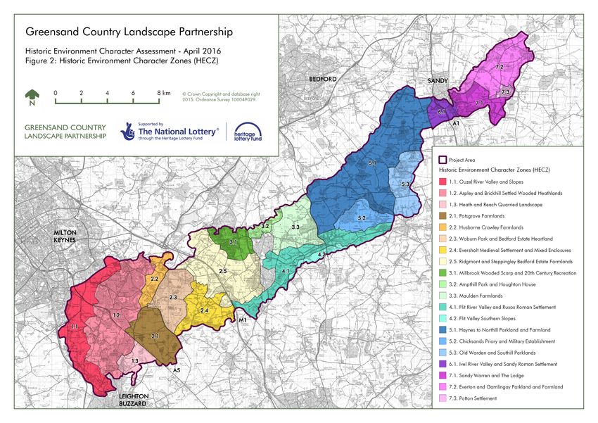
Contents
1. INTRODUCTION ............................................................................................................................... 4
1.1 BACKGROUND.................................................................................................................................. 4
1.2 THE PURPOSE OF HISTORIC ENVIRONMENT CHARACTERISATION ....................................................... 5
1.3 OBJECTIVES OF THE GREENSAND COUNTRY HISTORIC ENVIRONMENT CHARACTERISATION ............... 6
1.4 METHODOLOGY ............................................................................................................................... 6
2. ARCHAEOLOGICAL AND HISTORICAL CONTEXT ...................................................................... 8
2.1 INTRODUCTION ................................................................................................................................ 8
2.2 GEOLOGICAL AND TOPOGRAPHICAL SETTING .................................................................................... 8
2.3 HUMAN OCCUPATION ..................................................................................................................... 10
3. HISTORIC ENVIRONMENT CHARACTER AREAS ...................................................................... 16
3.1 INTRODUCTION .............................................................................................................................. 16
3.2 DESCRIPTIONS............................................................................................................................... 16
4. HISTORIC ENVIRONMENT CHARACTER ZONES ....................................................................... 20
4.1 INTRODUCTION .............................................................................................................................. 20
4.2 DESCRIPTIONS............................................................................................................................... 20
5. OPPORTUNITIES............................................................................................................................ 61
5.1 INTRODUCTION .............................................................................................................................. 61
5.2 PROGRAMME THREADS IDENTIFIED BY THE GREENSAND COUNTRY LP ............................................ 61
5.3 THIRD PARTY GRANT SCHEME FOR COMMUNITY HERITAGE PROJECTS ............................................ 62
6. APPENDIX 1 – METHODOLOGY ................................................................................................... 63
6.1 HISTORIC LANDSCAPE CHARACTER AREAS ..................................................................................... 63
6.2 ARCHAEOLOGICAL CHARACTER AREAS ........................................................................................... 69
6.3 RURAL BUILT ENVIRONMENT CHARACTER AREAS ............................................................................ 74
6.4 SUMMARY TABLE OF AREAS AND ZONES ........................................................................................ 81
6.5 HISTORIC ENVIRONMENT CHARACTER ZONES SCORING .................................................................. 83
7. BIBLIOGRAPHY ............................................................................................................................. 86
List of Figures
Figure 1: Historic Environment Character Areas
Figure 2: Historic Environment Character Zones
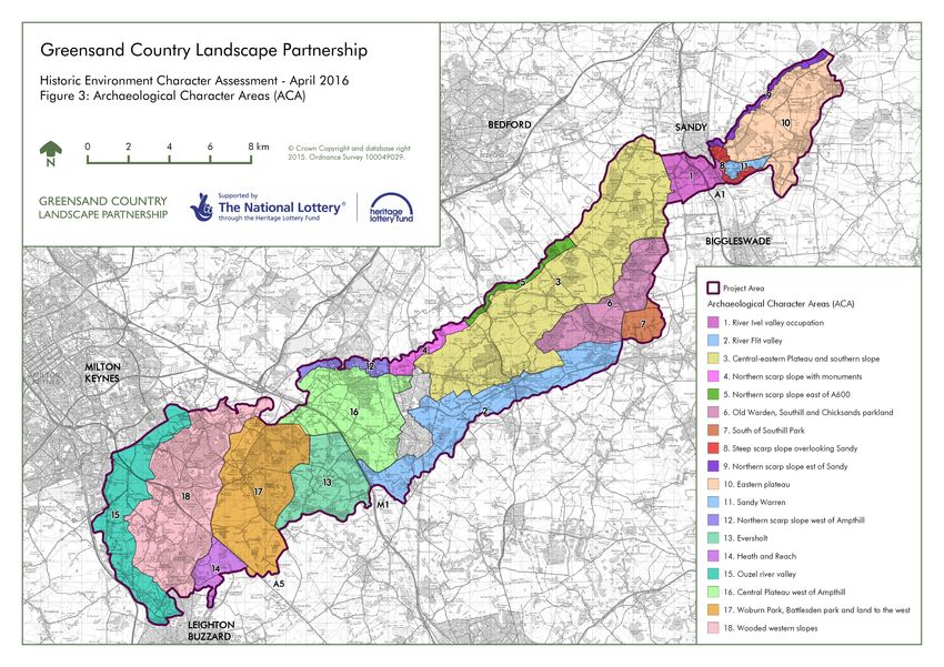
Figure 3: Archaeological Character Areas
Figure 4: Rural Built Environment Character Areas
Figure 5: Historic Landscape Character Areas
All figures are bound at the back of the report.
Greensand Country Landscape Partnership, Historic Environment Characterisation 1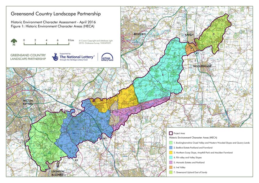
Preface All statements and opinions in this document are offered in good faith. Albion Archaeology cannot accept responsibility for errors of fact or opinion resulting from data supplied by a third party, or for any loss or other consequence arising from decisions or actions made upon the basis of facts or opinions expressed in this document. This document has been prepared by Christiane Meckseper (Project Officer) with contributions by Fiona Fyfe. All images were taken by Fiona Fyfe unless otherwise acknowledged. Albion Archaeology is grateful to Stephen Coleman and Sam Mellonie (Central Bedfordshire HER ), Julia Wise (Buckinghamshire HER) and Sally Croft (Cambridgeshire HER) for providing the relevant data. No data was received from the Milton Keynes HER. Stephen Coleman and Martin Oake (Central Bedfordshire Planning Archaeologist) have commented on draft versions of the areas and zones. Stephen Coleman has provided additional information for mapping the Historic Landscape Character Areas. Albion Archaeology St Mary’s Church St Mary’s Street Bedford, MK42 0AS : 0300 300 68781 E-mail: cf.meckseper@albion-arch.com Version History Version Issue date Reason for re-issue 1.2 25 April 2016 Further edits 1.1 18 April 2016 Comments by Claire Poulter and Jon Balaam 1.0 17 February 2016 n/a DRAFT 20 November 2015 n/a Key Terms Throughout this document the following terms or abbreviations are used: ACA Archaeological Character Area AVDC Aylesbury Vale District Council CBC Central Bedfordshire Council DBD Designation Bedfordshire HECA Historic Environment Character Area HLCA Historic Landscape Character Area HLCZ Historic Landscape Character Zone HER Historic Environment Record LP Landscape Partnership MK Milton Keynes NHLE National Heritage List for England RBECA Rural Built Environment Character Area SM Scheduled Monument Greensand Country Landscape Partnership, Historic Environment Characterisation 2
Greensand Country Landscape Partnership, Historic Environment Characterisation 3
1.      INTRODUCTION
1.1    Background
The Bedfordshire Rural Communities Charity (BRCC) together with the Greensand
Trust are leading the Heritage Lottery Fund funded Greensand Country Landscape
Partnership Programme.

The Greensand Country is a long wooded ridge of Lower Greensand bedrock crossing
central Bedfordshire from Leighton Buzzard in the south-west to Gamlingay in the
north-east. It is recognised as a National Character Area (no. 90) “Bedfordshire
Greensand Ridge” by Natural England.

For the purposes of the Greensand Country Landscape Partnership programme, the
Greensand Ridge has been named ‘Greensand Country’ to include the low lying river
valleys and low lying areas that lie at the edge of the ridge but are an integral part of
its distinctive character. It will therefore be referred to as Greensand Country within
this report.

Its topography and geology have led to the Greensand Country having an
archaeological and historical development distinct from the more fertile clay vales to its
north and south. Steep ridges led to the establishment of prehistoric hillforts and
medieval fortified structures along its northern edge. The acidic “marginal” soils of the
ridge and the resulting heathland and woodland, together with steep slopes in parts of
the Greensand Country, meant that agricultural exploitation was difficult.

Due to its physical and agricultural marginal location, the Greensand Country was not
intensively settled initially but used for the siting of monasteries. After the dissolution of
the monasteries the land was given to major landowners who established their own
stately homes and gardens, deer parks and estate villages. Much of the economic
exploitation of the ridge was in the form of forestry, rabbit warrens and livestock
grazing. Only with the onset of more modern farming methods were large areas of the
ridge turned into arable land, most notably by the Duke of Bedford, who established
innovative farming techniques and built a large number of “model farms”.

The historic environment is a central resource for modern life. It has a powerful
influence on people’s sense of identity and civic pride. Its enduring physical presence
contributes significantly to the character and sense of place of both rural and urban
environments. However, modern land use and the rapidly expanding built environment
have led to the decline of the archaeological and built heritage of the Greensand
Country.

The Landscape Partnership Programme seeks to reverse some of this decline, raise
awareness among local people and visitors of the Greensand Country’s unique
heritage, and involve them in creating a sustainable future.

To underpin their programme the Greensand Country Landscape Partnership is
producing a Landscape Conservation Action Plan. Part of this Plan is a Historic
Environment Characterisation Study which will inform the Plan but will also be capable

Greensand Country Landscape Partnership, Historic Environment Characterisation              4
of acting as a stand-alone document, informing other strategies, policies and planning
decisions. Other strands of the Landscape Conservation Action Plan are a Landscape
Character Assessment, Sandstone Structures Audit and Historic Parkland Audit.
Albion Archaeology in association with Alison Farmer Associates and Fiona Fyfe was
commissioned to undertake the Historic Environment Characterisation Study part of
the Landscape Conservation Action Plan.
1.2 The Purpose of Historic Environment Characterisation
Detailed, local spatial planning and green infrastructure provision is contained in the
Local Development Schemes for Central Bedfordshire, Aylesbury Vale District Council
and Milton Keynes Unitary Authority. These are supplemented by Green Infrastructure
Plans like the Mid Bedfordshire Green Infrastructure Plan ( 2008) , the Aylesbury Vale
Green Infrastructure 2011-2026 (AVDC 2011), Milton Keynes GI plan (2008) and
Cambridgeshire GI Strategy (CCC 2011).
It has to be noted that on 19th November 2015 the full Council resolved to withdraw
the Central Bedfordshire Local Plan and to begin work on a new plan. Until the new
local plan is adopted, development in the central part of the unitary authority (formerly
Mid Bedfordshire District) is covered by the Central Bedfordshire – North Local
Development Framework (LDF) and the South Beds local plan. The LDF policies are
set out in the Core Strategy and Development Management Policies Development
Plan Document adopted by the Council on 19th November 2009.
As part of Local Development Plans development impact will have to be managed
strategically, so that development can be shaped and directed in order to protect,
conserve and enhance the historic environment and create new communities which
respond to local character and sense of place.
To achieve this requires the development of more holistic approaches which go
beyond the traditional site by site approach to development control and planning.
Historic Environment Characterisation is one of those approaches. It is part of a
system of assigning significance and value to a resource and assessing development
impact and its significance upon that resource. It also provides tools for identifying
development opportunities for that resource.
For the historic environment this allows more effective prioritisation, resource
allocation, and management, within a broader characterisation framework. Broadly,
the purpose of historic environment characterisation is set out below.
Establish the historic environment as a key factor in developing a sense
of place and context for new development.
Provide historic environment input into Development Strategies, Local
Plans and other strategic documents such as Village Plans.
Identify historic environment issues, both constraints and opportunities,
early in the development process.
Greensand Country Landscape Partnership, Historic Environment Characterisation 5
Identify opportunities for using the historic environment as part of Green
Infrastructure Plan policies and influence Green Infrastructure delivery.
Develop a development control tool and provide a model methodology
for prospective developers to use in assessing the impact of individual
development proposals on the historic environment.
1.3 Objectives of the Greensand Country Historic Environment
Characterisation
The Greensand Country Historic Environment Characterisation Study has several
objectives which are in addition to the general purpose of historic environment
characterisation and specific to the Greensand Country character area. These
objectives are set out below.
To improve and promote the understanding and appreciation of the
historic environment of the Greensand Country Landscape Partnership
Area.
To engage communities in the process in order to raise awareness of
local heritage features and secure input on what features they value.
To identify opportunities for using the historic environment in the
development of the Greensand Country Landscape Conservation Action
Plan (LCAP) and subsequent delivery of the LP programme.
1.4 Methodology
The study area boundary supplied included the Greensand Country Landscape
Partnership area, excluding the urban areas of Ampthill and Flitwick.
The methodology involved a two-stage process. The first stage involved thematic
characterisations of different aspects of the historic environment: Archaeological
Character Areas (ACA), Historic Landscape Character Areas (HLCA), and Rural Built
Environment Character Areas (RBECA).
Some of these datasets already existed from previous studies, whilst others have
needed to be created using background data such as the HER, and local knowledge of
enclosure patterns. It has also been necessary to incorporate information from
Buckinghamshire and Cambridgeshire into existing datasets in order to create a
seamless characterisation across the entire Greensand Country.
The second stage involved using the thematic characterisations to identify and refine
larger scale Historic Environment Character Areas (HECA) and smaller scale Historic
Environment Character Zones (HECZ). Historic Environment Character Areas are
designed to inform strategic planning at a county-wide level. Historic Environment
Character Zones (HECZ) break down the larger Historic Environment Character Areas
(HECA), identified above, into smaller zones, which are of a size more suitable for
strategic planning on a more localised basis. HECZs can be used at an early stage in
the planning process to identify impacts on the historic environment, thereby
highlighting the need for informed conservation, enhancement and mitigation.
Greensand Country Landscape Partnership, Historic Environment Characterisation 6
The methodology and descriptions for the HECAs and HECZs is given in the main
body of the report in Sections 3 and 4. They are illustrated in Figures 1 and 2. The
methodology and definition of the thematic datasets is given in the Appendices.

Greensand Country Landscape Partnership, Historic Environment Characterisation         7
2.     ARCHAEOLOGICAL AND HISTORICAL CONTEXT

2.1    Introduction
This section presents a broad narrative summary of the archaeological and historical
context of the Greensand Country within Bedfordshire. It draws heavily on previous
studies, in particular An Archaeological Research Framework for Bedfordshire (Oake
et al 2007), Bedfordshire Historic Landscape Characterisation (Simco 2005) and the
Bedfordshire Aggregates Archaeological Resource Assessment (Woburn Sands
Formation AS-A) (CBC 2011). The latter has been used to compile the archaeological
background in this report and, unless otherwise referenced, is the main bibliographical
source for the text in this section.

The information is presented in chronological order from prehistoric times to the
present day. No detailed account of all aspects of the county’s historic environment is
attempted. Rather, the aim is to identify the main trends and elements within it.
Consideration is also given to the context of discovery, with the aim of elucidating the
main elements in our understanding of the county’s historic environment.

2.2    Geological and Topographical Setting
The geology and topography of the Greensand Country have strongly influenced the
evolution of the area’s historic environment.

2.2.1 Solid geology
The south-west to north-east trending “grain” of Bedfordshire is provided by the solid
geology. The youngest rocks, Lower, Middle and Upper Chalk, appear on the surface
in the south of the county as the Bedfordshire Chilterns. Moving northwards, the
Chalk is successively underlain by older Gault Clay, Lower Greensand, Oxford Clay,
Cornbrash and Oolitic Limestones.

This super-imposition produces a “corrugated” effect, moving from the highest point of
the county, the Chilterns in the south towards the Greensand Country, which is rising
out of the surrounding clay plateaus to its north and south. Following the geological
grain of the country the Greensand Country forms a distinctive band of higher ground
stretching from Leighton Buzzard in the south-west to Gamlingay in the north-east.

The Lower Greensand actually continues in a south-west to north-eastern band across
the entire country, appearing in Norfolk, Cambridgeshire, Bedfordshire and
Buckinghamshire. Within Bedfordshire the Lower Greensand is known as Woburn
Sands Formation and is informally divided into Red Sands, Silver Sands and Brown
Sands, the colours being the result of varied inclusions of iron oxide, silt and
glauconite.

Heavy concentrations of iron oxide give rise to sandstone and ironstones which are
interbedded with Fullers Earth (a very fine clay that was historically used for cleaning
or “fulling” wool and textiles).

2.2.2 Drift geology
Partially draped over this underlying framework are a variety of superficial deposits.
Greensand Country Landscape Partnership, Historic Environment Characterisation             8
In the Greensand Country there are drift deposits of Boulder Clay in the south-western
and central-northern part of the ridge. Oxford Clay intrudes along the edge of the ridge
from the Bedfordshire clay vale to its north. Other significant drift deposits are the
alluvial gravels of the valleys of the Rivers Ivel, the Flit and the Ouzel.

2.2.3 River gravels
The gravel terraces of the river valleys undoubtedly were a focus of settlement from
the earliest human times. However, this natural bias has been accentuated by
archaeological evidence that has been recovered as a result of quarrying and
development in the river valleys. The well-drained nature of gravel terraces leading to
a better visibility of archaeological sites also makes them particularly suitable to aerial
prospection, which potentially further skews the overall pattern.

2.2.4 Quarrying
Where these deposits outcrop at the surface, they have long been (and in many cases
continue to be) exploited as mineral resources: sand and Fuller’s Earth around
Leighton Buzzard, Woburn and Aspley Guise, clay for brickmaking in the central part
of the ridge, and sand to the east of Sandy. Phosphate pebble beds at the base of the
Lower Greensand were exploited for fertiliser production during the late 1800s to early
1900s.

A number of quarry locations used to extract solid sandstone have been identified
within the Bedfordshire part of the project area by the Strategic Stone Study, a project
undertaken by Historic England (formerly English Heritage) and the British Geological
Survey (BGS) researching the use of building stone in England. However, Garrand
notes that the extraction of sandstone as a building material has often been secondary
to the quarrying of aggregates, or was extracted in parallel with sand quarrying,
because the nature and quality of the stone deposits are so variable across the
Greensand Country (Garrand 2015).

Due to the high variability of sandstone as a building material only a small proportion
of it was used for the construction of high status buildings, like bridges and parish
churches The majority of the building stone was used for secondary structures such as
boundary walls, modest houses and cottages and occasional farm buildings and
estate lodges (Garrand 2015).

2.2.5 Topography
The Greensand Country is a relatively low ridge with the highest point at c.170 AOD at
its western end on Bow Brickhill heath. Towards the north it has a pronounced and
steep scarp slope which levels off at the top to form the main undulating plateau of the
ridge. This falls gently towards the south and east, forming dip slopes into the valley of
the River Flit in the south and Ivel in the east. Short, steep valleys, which were formed
during the Ice Age, break up the landscape of the ridge. These are important visual
features but make farming difficult.

The River Flit has carved a relatively narrow valley into the Lower Greensand along
the southern edge of the ridge, while the River Ivel lies within a wide valley with
extensive gravel banks either side of the watercourse. To its east the ridge again rises

Greensand Country Landscape Partnership, Historic Environment Characterisation            9
as a steep slope, with the Lower Greensand continuing eastwards into
Cambridgeshire where it disappears under overlaying clay deposits near Gamlingay.

The River Ouzel loops around the base of the Greensand Country in the west and the
western slopes are also steep and heavily wooded.

2.3    Human occupation

2.3.1 Early prehistoric evidence (Palaeolithic to Bronze Age)
Evidence for early prehistoric activity in the Greensand Country is almost exclusively in
the form of flint tools. The majority of the finds are unstratified or come from secondary
contexts. Where flints have been found in the ploughsoil they are often not associated
with any underlying features of the same date, suggesting an absence of more
permanent sites. Some of the finds may be chance losses by groups of hunter
gatherers moving through the regions, others indicate the existence of flint knapping
and production sites with one site including the possible presence of a working floor
(HER 2595).

Two noticeable collections come from the central part of the Greensand Country. They
are an assemblage of finds retrieved during fieldwalking prior to the construction of
the Aylesbury to Steppingley gas pipeline south-west of Flitwick (HER 15844). This
contained a large number of Mesolithic cores, blades, bladelets and microliths, with
the diverse number of material suggesting that this could be a flint knapping and
processing site.

The other is an assemblage collected by an amateur archaeologist over a period of
thirty years in the area of Laurel Wood within Ampthill Park (HER 18269) and
comprises 4,200 pieces of flint. It has not been fully analysed but contains a large
number of Neolithic type blades, flakes, cores and debitage.

The nature of early prehistoric activity in the Greensand Country is difficult to conclude
from the available material. Most of the finds spots are either on the upper slopes of
the ridge at good vantage points or from sites within the river valleys. It is assumed
that the ridge would have been largely wooded in the early prehistoric period and the
available evidence suggests the presence of seasonal and temporary hunter-gatherer
sites used for both flint production and the processing of animal and plant remains.

Apart from a small number of antiquarian finds, and the Ampthill amateur collection,
most of the flint artefacts were retrieved during archaeological investigations prompted
by the planning process. It is therefore likely that the lack of artefacts also mirrors the
relatively low number of commercial archaeological investigations on the ridge.

2.3.2 Bronze Age
The end of the Neolithic period (c. 2,000 BC) saw a number of changes in pottery
types, the emergence of metal artefacts, the abandonment of earlier communal
monuments and an increased emphasis on individual burial. Within Bedfordshire, in
terms of the distribution of the evidence and the absence of definite settlement sites,
this period has much in common with the preceding Neolithic.

Greensand Country Landscape Partnership, Historic Environment Characterisation            10
As in much of lowland Britain, the study of this period has been dominated by the
study of burial monuments or barrows. The sites of around 150 have been identified
within the county as a whole. The great majority are on the Great Ouse and Ivel
gravel terraces; there are only 25 on the chalk uplands and a handful elsewhere.
Within the study area only 4 ring ditches are recorded, all within or overlooking the
river valleys.

The absence of evidence for barrows suggests that the ridge may still have supported
considerable areas of woodland in the Bronze Age period. A possible pillow mound
and round barrow were recorded on the northern scarp slope of the ridge to the north-
west of Haynes West End (HER 7487 and 7488). However, the pillow mound is most
likely a medieval rabbit warren and there is no physical evidence for the round barrow
actually existing.

Bronze Age flints do occur within the assemblages discussed in Section 2.3.1 above.
These are the only indicators for potential settlement sites on the ridge, no other
evidence for settlements or agricultural exploitation in the form of field systems has yet
been found. This could either represent a real lack of those sites in an area that may
not yet have been part of Bronze Age woodland clearance, or again a bias of visibility
in the archaeological resource

2.3.3 Iron Age
Hillforts are one of the archetypal features of Iron Age Britain and there are several
examples in the Greensand Country. Three are located on the steep ridges
overlooking Sandy in the east of the study area. These are Galley Hill, Sandy Lodge
and Caesar’s Camp. A further good example, Danesborough Camp, lies within
Buckinghamshire on the western edge of the ridge. Craddocks Camp is a possible
hillfort overlooking the River Ouzel to the west of Heath and Reach.

For the first time in the history of the Greensand Country, there is unequivocal
evidence for the existence of farms, practising a mixed arable/pastoral regime, and
settlement density increases towards the end of the Iron Age. Not only are long-
settled areas like the river gravels more intensively exploited but sites also appear in
previously under-exploited areas, such as the Greensand Country. There are a
relatively large number of cropmark sites, all situated on the upper slopes of the ridge.
These are undated but on morphological grounds most likely represent Iron Age to
Roman settlement sites and agricultural features.

In a few cases, where archaeological investigations of those cropmarks have taken
place prior to development, Iron Age and Roman occupation was confirmed. Iron Age
pits and ditches and a late Roman corn drying oven were recorded north of Haynes
Church End (HER 15840). Several ditches and two cremations dating from the Iron
Age/Roman period, part of a larger cropmark complex, were excavated at Sweetbrier
Farm (HER 16752) west of Old Warden.

2.3.4 Roman
The infrastructure of small towns and roads was a major innovation, which firmly
embedded the county into the administrative and political structures of lowland Roman
Britain. The two major north-south routes beneath the present-day A5 and A1 trunk
roads both cross the Greensand Country, the A1 in its east and the A5 Watling Street
Greensand Country Landscape Partnership, Historic Environment Characterisation      11
in its west. These roads would have been supplemented by a network of minor roads
and trackways, the precise extent and nature of which have been the subject of
considerable debate. A small section of Roman road was excavated west of Sandy
(HER 11984)

The two towns in the county were both strategically positioned on the major routes.
Sandy (HER 444) was located at the point where the River Ivel cuts through the
Greensand escarpment, close to a group of Iron Age hillforts. By the 3rd century AD it
was over 10ha in extent, and featured two cemeteries on its outskirts. The second
major Roman settlement was Dunstable to the south of the Greensand Country.

A smaller, 4th century fortified town was located within the Ouzel Valley to the south
east of modern Fenny Stratford. Magiovinium lay either side of the Roman Watling
Street. No large scale excavations have yet been undertaken within the settlement but
painted wall plaster, tesserae, tiles, pottery and coins have been found during
fieldwalking. The town also had a cemetery outside its defences.

Beyond the towns there was a variety of settlement forms, including large villages and
smaller farmsteads. Ruxox (HER 918), on the southern dipslope of the Greensand
Country close to the River Flit, represents an extensive area of Roman settlement. The
amount of pottery, tile and fragments of “Venus” pipe clay figurines suggest that it was
a villa as well as a temple site.

Farmsteads, some comprising quite extensive linear arrangements of enclosures,
were also a common feature of the countryside, perpetuating the mixed
arable/pastoral economy which had developed during the preceding Iron Age. Similar
to the Iron Age period, many of the cropmark complexes recorded within the study
area are likely to be Roman in date. The location of those sites along the northern
edge of the central ridge plateau, just set back from the steep scarp slope, is
noticeable.

Another distinctive site type which occurs in the Greensand Country, and which has
only been identified through excavation, is the kiln. Several pottery kilns have been
excavated, noticeable examples being located in Woburn (HER 11867, 18268),
Ampthill (HER 6743) and Hillfoot Farm (HER 9156). All sites are located in areas of
clay overlying the Lower Greensand bedrock and are examples of the early industrial
exploitation of the ridge.

2.3.5 Anglo-Saxon
There are very few heritage assets dating to the Anglo-Saxon period recorded in the
Greensand Country. The only evidence for early Saxon occupation was uncovered
during trial excavations at the site of Ampthill Castle (HER 810). This comprised a
series of linear features with fragments of domestic pottery vessels dating between the
5th to 7th centuries AD. The features could either represent timber slots for a
substantial building, or the remains of an enclosure with a series of internal divisions. It
is possible that the features represent a settlement pre-dating the castle.

Postholes, a hearth and two parallel ditches dating to the Saxo-Norman period (850 –
1150 AD) were excavated at Haynes park in advance of the construction of a new

Greensand Country Landscape Partnership, Historic Environment Characterisation           12
access road (HER 15840). They were part of a multi-period settlement with preceding
Iron Age and Roman occupation.

The scheduled monument of Quince Hill (HER 972) at Old Warden consists of an
earthwork forming a central enclosure c. 80m in diameter surrounded by two sets of
banks and ditches. Ringworks date to between the late Saxon period and the 12th
century AD and it is likely that they represent either military fortifications or defended
manorial or aristocratic settlements.

Many of the villages and hamlets of the Greensand Country are listed in the
Domesday Survey of 1086 AD, showing that they have late Saxon origins. However,
archaeological evidence for those early settlement cores is only slowly coming to light
and often depends on development-led investigations.

2.3.6 Medieval
The medieval period is characterised by a much greater visibility and physical
presence of sites. The impact of the Norman conquest is reflected in the emergence of
fortified sites, which are found throughout the country. Some take the form of simple
mottes without a bailey and may represent early Norman mounds capped with wooden
towers. Some of the more highly fortified motte and bailey castles were superimposed
upon existing village or town settlements. There are two Norman castles in the
Greensand Country, one is Cainhoe Castle (HER 225) at its southern edge and the
other is a motte in Exeter Wood on top of the northern scarp slope (HER 9263).

The very mixed pattern of rural settlement within Bedfordshire could suggest that
individual styles of lordship were an important factor in the development of the
county’s rural landscape. Overall, the settlements within the county may be classed
as mainly dispersed with some nucleation. However, patterns often vary widely from
one parish to another even within the similar terrain of the Greensand Country.

The county is especially rich in moated sites, with one of the densest concentrations in
England. Moats are often associated with patterns of dispersed settlement and
irregular field systems; some have manorial associations. The origin of many is
probably associated with assarting, the creation of new farmland out of woodland in
the 12th and 13th centuries. The main concentration of moats is in the north of
Bedfordshire on the clay soils but many are found in the Greensand Country.

The marginal and secluded nature of land in the Greensand Country led to
establishment of a relatively large number of monastic sites. These are Woburn
Abbey, Old Warden (both Cistercian), Chicksands (Gilbertine), and Bushmead
(Augustinian).

After the dissolution of the monasteries the monastic land was either given to
members of the gentry for services rendered to the king, or acquired by them. Large
country houses with surrounding parks were established in the post-medieval period
which are still in private hand. None of the monastic sites in the Greensand Country
have been extensively studied or investigated archaeologically, but work is currently
undertaken by an amateur historian on researching the history of Old Warden.

Greensand Country Landscape Partnership, Historic Environment Characterisation               13
Evidence of the rural economy survives in a large range of features within the
landscape of the ridge. Fishponds, wildfowl lakes, rabbit warrens and mill sites are
often associated with manorial and ecclesiastical establishments. Only about 50% of
the countryside was farmed in open fields. Woods were also an important element of
the rural economy, supplying raw materials and supporting a range of industries and
crafts.

2.3.7 Post-Medieval and Industrial
A notable feature of the post-medieval landscape is the development of parks and
gardens usually associated with the larger and grander houses in the county. These
spread throughout the county but the most extensive and often most innovative and
striking are found in the centre of the county in the Greensand Country. Part of the
reason for this the location of medieval monastic houses in this area which at the
Dissolution became the centre of new aristocratic estates; for example Woburn and
Chicksands. Other important parks in central Bedfordshire include Wrest Park,
Ampthill Park and Southill.

The existence of large country estates and also of smaller manorial estates meant that
much of the agricultural land in the Greensand Country was enclosed from the
medieval period onwards. Much of this enclosure was small scale and led to the
creation of a distinctive pattern of irregular fields. In a small number of parishes this
field pattern still survives. Examples are the fields to the north-west of Maulden in the
parishes of Maulden and Haynes, and land along the north-eastern edge of the
Greensand Country where the parishes of Cardington, Cople and Willington extend up
to the ridge and created arable fields through assarting.

In other parishes this pattern, and the remaining open field system, was later replaced
by a new system of large rectangular fields and straight roads. In a process that is
symptomatic for the large country estates on the ridge, in particular those owned by
the Duke of Bedford, this large scale re-organisation was undertaken by the estates
themselves, leading to a similar pattern of fields to Parliamentary enclosure.

The 8th Duke of Bedford in the mid-19th century was part of the agricultural revolution
and restructured his lands to take full advantage of modern farming methods, including
the steam plough. He also built a large number of “model farms” designed for optimum
efficiency. Many of the farms have a very distinctive E-shaped ground plan and some
are accompanied by steam engine houses. A good examples is Park Farm in the
parish of Steppingley, where a possible steam engine house still survives.

Many of the rural buildings of this period bear witness to post-medieval economic
activities. They include dovecots, lock-ups, animal pounds, smithies, windmills,
watermills, horse engine houses, donkey wheel houses, barns and other farm
buildings. Many of them were built of brick.

Brick making is another indicator of the increasing importance of rural industry at the
time. Clay pits for the extraction of clay are recorded in several areas in the
Greensand Country. Other materials that were quarried and exploited in the post-
medieval period were sand and gravel, pockets of which occur all over the ridge, and
Fullers Earth. Rich deposits of Fullers Earth existed at Wavendon Heath, Aspley Heath
and Clophill. It was first mined in the Roman period and in 1765 the Duke of Bedford
Greensand Country Landscape Partnership, Historic Environment Characterisation         14
began commercial mining. The deposits were exploited commercially until the turn of
the 21st century (Bedfordshire and Luton Geology Group 2010).

Sandstone was probably first quarried on a large scale in the medieval period in order
to construct the many parish churches within the Greensand Country which are
predominantly built of sandstone. However, Garrand notes that the majority of
churches were extensively restored in the 19th or early 20th centuries. This continued
the demand for locally produced stone, even though many of the pits exclusively
devoted to the extraction of building stone had ceased working by the late 19th century
(Garrand 2015).

Another major development in eastern Bedfordshire was the emergence of large-scale
market gardening. The rivers Great Ouze and Ivel was made navigable in the 17th and
late 18th century respectively, stimulating the urban development of Bedford and many
of the smaller centres along the waterways. Brewing, malting, tanning, straw plaiting
and hat making were all important industries carried out in Bedfordshire’s towns.
Historic town buildings survive in various places and in many cases their date may be
earlier than so far assumed. When timber-frames became unfashionable in the 18th
century, many town buildings were completely refaced with brick and stone, masking
the earlier structure behind their facades.

The introduction of the railways in the middle of the 19th century was crucial to the
development of the county’s towns and the growth of several of its industries, for
example quarrying, brick making and the transport of many of the goods from its
smaller scale industries. The steam engine also revolutionised many of the industrial
processes carried out in Bedfordshire’s rural environment like cultivation and milling.

Greensand Country Landscape Partnership, Historic Environment Characterisation        15
3. HISTORIC ENVIRONMENT CHARACTER
AREAS
3.1 Introduction
The Historic Environment Character Areas (HECA) are predominantly based on the
HECAs which were defined as part of the Mid Bedfordshire Green Infrastructure (GI)
Plan 2008 (Greensand Trust 2008) which covers the area of the Greensand Country.
The Mid Bedfordshire GI Plan supports the regional Bedfordshire and Luton Strategic
Green Infrastructure Plan (BLGIC 2007) and is in turn supported by GI plans drawn up
on a parish level.
The zones applicable to the Greensand Country in Bedfordshire as defined for the Mid
Bedfordshire GI plan have been re-used for this study. Their boundaries were refined
to an appropriate scale for this project, for example making them fit field boundaries.
They were also refined to avoid ‘slivers’ of HECAs at the edges of the project area,
and to remove ‘artificial’ boundaries along the Bedfordshire County boundary.
During the refining process, the boundaries of RBECAs, ACAs and HLCAs were also
taken into account. A summary table of which zone and sub-area make up each
HECA and how the different elements are nested is given in Appendix 6.4. As there
are so many different boundaries involved, a figure showing all elements
superimposed would not be illustrative.
The areas have been given new unique numbers, but the numbers are cross-
referenced with those given in the Green Infrastructure report (Greensand Trust 2008),
where applicable, and prefixed with GI. A total of seven HECAs were identified across
the Greensand Country.
Parts of the Greensand Country which lie in Buckinghamshire, Milton Keynes and
Cambridgeshire have been incorporated into the HECAs. The HECAs therefore cross
county boundaries. The location and extent of the HECAs are shown on Figure 1.
Opportunities of enhancement for each area, as identified in the relevant Green
Infrastructure plan for each county are given at the end of each area description. The
level of detail of the opportunities reflects the level of detail given in the Green
Infrastructure plans. They are intended to highlight certain elements, characteristics of
or sites within a HECA but do not provide a detailed exploration of each opportunity.
3.2 Descriptions
3.2.1 HECA 1 (GI 37): Buckinghamshire Ouzel Valley and western wooded
slopes and quarry lands
Key Characteristics:
Wooded Greensand upland / former heathland to west of Woburn and
north of Leighton Buzzard.
Greensand Country Landscape Partnership, Historic Environment Characterisation 16 Ironstone- and brick-built settlements at Aspley Guise, Aspley Heath,
Heath and Reach.
Former and extant sand quarries on the SW side of A5;
Duke of Bedford land to NE is unquarried.
Rushmere Country Park. Remains of medieval woodland management.
Bisected by Watling Street (A5).
Opportunities:
Improve and create interpretation and trails to highlight:
o Remains of extractive industries, including narrow gauge railway.
o Links into Milton Keynes where Greensand escarpment overlooks
the Ouzel Valley.
3.2.2 HECA 2 (GI 36): Bedford Estate parkland and farmland
Key Characteristics:
Woburn Park and Bedford Estate land.
Estate settlements, e.g. Husbourne Crawley, Ridgmont, Tingrith, Milton
Bryan etc and model farms.
Woburn Experimental Farm.
Steppingley Park.
Traversed by M1.
Archaeological potential largely untapped.
Deserted medieval settlement at Potsgrove and Segenhoe (latter
includes a ruined church).
Eversholt parish: fossilised medieval landscape with early enclosure
fields and dispersed small settlement pattern.
WW2 black propaganda wireless station at Milton Bryan.
Opportunities:
Improve and create interpretation and trails to highlight:
o History of agriculture.
o History of the impact of the Duke of Bedford (agriculture and
estate architecture).
o Medieval sites and earthworks
o WW2 dimension
3.2.3 HECA 3 (GI 33): Northern scarp slope, Ampthill Park and Maulden
farmland
Key Characteristics:
Block of Greensand / Boulder Clay upland between Clophill and
Lidlington.
Centred on Maulden and Ampthill, with smaller settlement at Millbrook.
Former heathland (with warrens), later given over to timber plantations.
Historic woodland at Maulden Wood and King’s Wood.
Greensand Country Landscape Partnership, Historic Environment Characterisation 17 Houghton House and Park.
Ampthill Park and House.
Opportunities:
Relatively well researched and presented archaeological landscape.
3.2.4 HECA 4 (GI 32): Flit valley and valley slopes
Key Characteristics:
Flit Valley between Shefford and Flitwick.
Much narrower floodplain than, for example, the Ivel Valley.
Meadowland.
Important palaeoenvironmental remains at Flitwick Moor, preserving
good pollen data.
Significant late prehistoric and Roman sites in upper reaches (e.g. Ruxox
Farm and Ampthill bypass).
Flitwick and Cainhoe castle earthworks.
Opportunities:
Improve and create interpretation and trails to highlight:
o Ruxox Roman site
o Flitwick and Cainhoe Medieval castle earthworks.
o Views in and out.
o Recent agricultural history (including market gardening and peat
cutting.)
o Flit Valley Walk
3.2.5 HECA 5 (GI 27): Monastic estates and parkland
Key Characteristics:
Large block of Greensand upland to north of River Flit.
Attractive mixed landscape of marginal heathland, arable, pasture and
woodland plantations, formerly extensive monastic estates.
Characterised by ancient woodland, extant (and former) parkland/estates
and country houses.
Moggerhanger Park, Shuttleworth, Southill Park, Chicksands Priory,
Haynes Park, Old Warden.
Some arable land amongst the woodland.
Complex network of minor roads.
Varied settlement pattern; Ickwell Green;
Much evidence for medieval assarting.
Buildings of a variety of ages.
Main building stone is ironstone.
Limited archaeological fieldwork but where undertaken (e.g. Haynes
Park) has revealed settlement from late prehistoric onwards.
Greensand Country Landscape Partnership, Historic Environment Characterisation 18Opportunities:
Improve and create interpretation and trails to highlight:
o Parkland, country houses (where accessible), development of
monastic estates.
o Woodland management.
o Long views to north-west across Bedford.
3.2.6 HECA 6 (GI 21): Ivel Valley
Key Characteristics:
Western side of the Ivel valley between Sandy and the Flit / Ivel
confluence.
Extensive glacial and river gravels.
Long standing extraction industry at Manor Farm (Sandy) has produced
a wealth of prehistoric and Roman archaeology.
Extensive market gardening with surviving onion sheds.
East-west grain to the landscape.
Crossed by historic transport routes: Roman road, Great North Road,
East Coast Mainline.
Opportunities:
Relatively well researched archaeological landscape.
3.2.7 HECA 7 (GI 19): Greensand upland east of Sandy
Key Characteristics:
Characterised by heathland (Sandy Heath, Potton Heath, Great Heath
(Cambs.)).
History of sand extraction.
Parkland associated with Woodbury Hall, Hazells Hall and Sandy Lodge.
Tetworth Gardens.
Settlements of Everton and Potton (the latter an historic town in its own
right).
Late medieval pottery production at Everton.
Opportunities:
Improve and create interpretation and trails to highlight:
o Iron Age hillforts (x3) controlling the gap in the Greensand Ridge.
o Market gardening provides interesting social history dimension.
Non-intrusive investigation of and research into Gamlingay Park
archaeological remains (Farmer 2015).
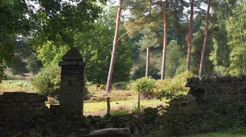
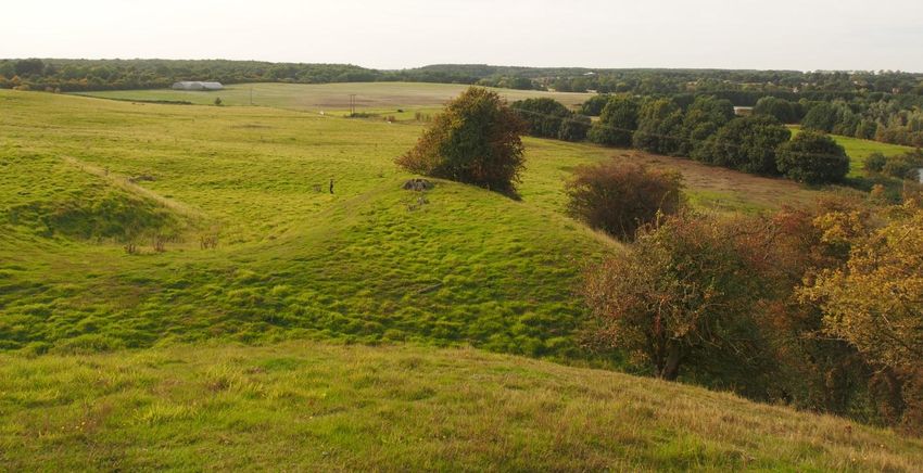
Greensand Country Landscape Partnership, Historic Environment Characterisation 194. HISTORIC ENVIRONMENT CHARACTER ZONES 4.1 Introduction The HECZs draw on the same strands of evidence used in the definition of the HECAs. With the latter there is a tendency to agglomerate subtle variations which can be looked at individually and in more detail within the framework of the HECZ. Of course, even the HECZs themselves could, theoretically, be broken down into smaller units. The descriptions of the HECZs seek to highlight their key characteristics and any particularly significant aspects of their historic environment resources. A condition assessment tries to identify any key issues relating to the management and protection of the historic environment resource of each individual zone. Each description comprises an overall summary, and summaries of the relevant characterisation strands. The precise methodology for the condition assessment of each HECZ is given in Appendix 6.5.1. A summary table of which HECZs and sub-areas make up each HECA and how the different elements are nested is given in Appendix 6.4. The boundaries of the HECZs within the Greensand Country are shown on Figure 2. 4.2 Descriptions 4.2.1 HECZ 1.1: Ouzel River Valley and Slopes Description This HECZ is located at the western end of the Greensand Country. It includes the valley floor of the river Ouzel (which contains the Grand Union Canal), and the sloping fields between the Ouzel valley and the woodlands of the Greensand Country. The HECZ is predominately farmland, with hedged fields giving a well-vegetated feel. It forms the setting of the Greensand Country in views from the west. The river valley location means that archaeologically there is a comparatively large number of cropmark complexes, suggesting prehistoric to Roman settlement. The known Roman small town of Magiovinium lies straddling the A5/Watling Street in the northern part of the HECZ. The historic landscape comprises flood meadows and pre C18th irregular enclosure with some parliamentary enclosure in the centre of the HECZ. There is some survival of medieval ridge and furrow. The HECZ is also traversed by the Grand Union Canal. Field Patterns Valley floor flood meadows and pre 18th century irregular enclosure. Some Parliamentary and C.19th enclosure fields with some modern boundary loss. Greensand Country Landscape Partnership, Historic Environment Characterisation 20
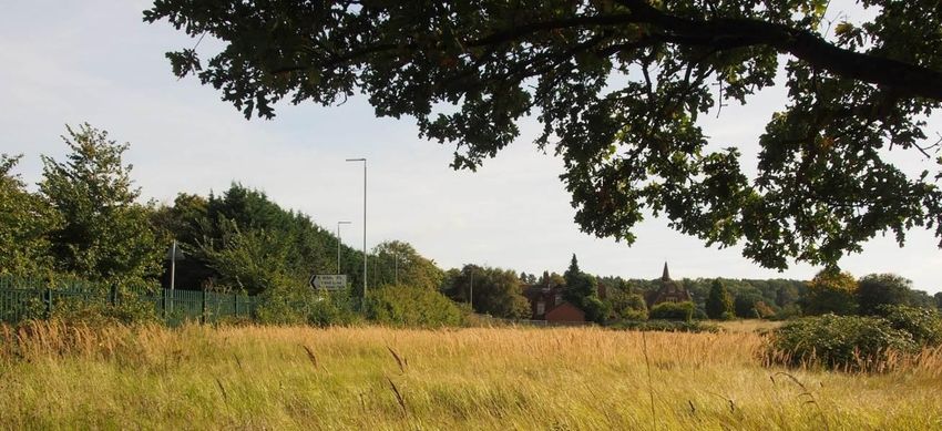
Looking south-west towards the Ouzel Valley and Grand Union Canal from near
Orchard Mill

Archaeological/ Historic Environment Components (See Appendices for fuller
descriptions)
Historic Environment Character Area (HECA): 1

Archaeological Character Areas (ACAs): 15

Rural Built Environment Character Areas (RBECAs): 15

Historic Landscape Character Areas (HLCs): 95

Main Archaeological Notification Areas (ANAs): Old Linslade Deserted Medieval Village,
Gravelly Ground possible Neolithic/Bronze Age ring ditch, Three Locks Golf Course
Roman farmstead and field system, Chelmscote medieval manor and fishponds.

Condition Assessment

        Criteria                 Description                                         Score
        Diversity of historic    Due to river valley location a relatively wide      2
        environment assets       range of assets, ranging from prehistoric to
                                 post-medieval.
        Survival                 Some disturbance by quarrying and                   2
                                 construction of Grand Union Canal. But also
                                 surviving cropmarks and sites.
        Documentation            Mainly HER data, some excavation reports,           2
                                 historical records.
        Group value              Wide range of unassociated assets, defined by       1
        association              river valley location but no group value as such.
        Potential                River gravels and known                             2
                                 settlements/cropmarks have good potential for
Greensand Country Landscape Partnership, Historic Environment Characterisation           21
investigation.
Sensitivity to Low lying area and closeness to Milton Keynes 2
change may facilitate development. However, on river
floodplain which is sensitive to change.
Amenity value Grand Union canal walk and Milton Keynes 2
boundary walk plus other footpaths. Good
views of Greensand Country western scarp
slope.
The Grand Union Canal at Willowbridge
Marina. The Greensand Country can be
seen in the distance, above the
narrowboat
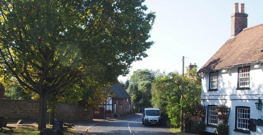
Greensand Country Landscape Partnership, Historic Environment Characterisation 224.2.2 HECZ 1.2: Aspley and Brickhill Settled Wooded Heathlands Description This HECZ is located at the western end of the Greensand Country. It is a relatively large HECZ, extending from Aspley Guise in the north to the edge of Leighton Buzzard in the south. It includes the settlements of Aspley Guise, Aspley Heath, Bow Brickhill, Little Brickhill and Great Brickhill, linked by winding and often sunken lanes. It is a relatively densely-wooded area, with a number of medieval settlements, often elevated, and a concentration of historic buildings. The villages contain a mixture of building materials and styles, including timber frame, thatch, brick, clay tiles, and sandstone plinths. There are relatively few estate cottages. Unusual buildings include C19th sanitoria around Aspley Heath, which developed so people could take the ‘beneficial air’ (with the smallest annual variation in air temperature in Britain). The HECZ includes the Iron-Age hillfort at Danesborough. It also contains extensive ancient woodland, plantations, and some parkland. Some have been adapted for recreational use, including extensive Country Parks and a golf course. Field Patterns Regular and irregular pre 18th century enclosure, fossilised strips and occasional assarts. Parliamentary and 19th century enclosure north of Great Brickhill and at Bragenham. Some ancient woodland, and from C.18th onwards extensive Duke of Bedford plantations. Occasional recent field boundary loss. Great Brickhill village centre Archaeological/ Historic Environment Components (See Appendices for fuller descriptions) Historic Environment Character Area (HECA): 1 Archaeological Character Areas (ACAs): 18 Rural Built Environment Character Areas (RBECAs): 13,14,15,18 Historic Landscape Character Areas (HLCs): 505,506,507, AVLCAs 5.2, 5.3, 6.1, 6.2 Greensand Country Landscape Partnership, Historic Environment Characterisation 23
Main Archaeological Notification Areas (ANAs): Danesborough Camp Iron-Age Hillfort;
Medieval Settlements

Condition Assessment

        Criteria                 Description                                           Score
        Diversity of historic    Mainly medieval and post-medieval.                    1
        environment assets       Danesborough Camp SM only known
                                 prehistoric asset.
        Survival                 Some disturbance by quarrying and tree                2
                                 plantation, golf course construction, expansion
                                 of settlement, but good preservation of other
                                 assets like medieval woodbanks and
                                 Danesborough Camp.
        Documentation            HER data, historical documentation                    2
        Group value              Assets are of a similar date, forming a very          2
        association              distinctive landscape, but not closely related to
                                 be of high group value.
        Potential                No significant disturbance but limited by             2
                                 woodland cover which restricts possible range
                                 of sites and investigation opportunities.
        Sensitivity to           Distinctive ridge edge location and woodland          2
        change                   means medium or large scale development
                                 would have a considerable impact on the
                                 historic environment.
        Amenity value            Large number of footpaths and country parks.          3
                                 Historic environment is part of sense of place
                                 and can be promoted (woodland, woodbanks,
                                 heath, settlement development)

Medieval wood bank at               Sunken Lane near Bow                 C.19th sanitorium, Aspley
King’s Wood                         Brickhill                            Heath

Greensand Country Landscape Partnership, Historic Environment Characterisation             24
4.2.3 HECZ 1.3: Heath and Reach Quarried Landscape Description This HECZ is located in the south-west of the Greensand Country. It includes the settlement of Heath and Reach, and the land to the east of the village. Extensive sand quarrying has had a major impact on this landscape, with resulting loss of historic landscape features. There are good views across the area from the A5 (which follows the line of the Roman road of Watling Street) and forms the eastern boundary of the HECZ. Field Patterns Parliamentary enclosure, much destroyed by quarrying and quarry restoration. Looking towards Heath and Reach from the A5. The face of a quarry can be seen on the horizon. The line of pine trees screens an active quarry. Archaeological/ Historic Environment Components (See Appendices for fuller descriptions) Historic Environment Character Area (HECA): 1 Archaeological Character Areas (ACAs): 14 Rural Built Environment Character Areas (RBECAs): 14 Historic Landscape Character Areas (HLCs): 93 Main Archaeological Notification Areas (ANAs): Post-medieval quarries; Medieval settlement; some ridge and furrow surviving. Condition Assessment Greensand Country Landscape Partnership, Historic Environment Characterisation 25
Criteria Description Score
Diversity of historic Mainly medieval settlement and agricultural 1
environment assets heritage assets.
Survival Large scale quarrying has removed much of the 1
historic landscape and its assets.
Documentation HER records and historical documentation 2
Group value No distinctive groupings of related assets. 1
association
Potential Some potential for investigation in undisturbed 1
areas.
Sensitivity to Could accommodate medium to large-scale 1
change development but area still lies adjacent to
extant heritage assets and landscape features.
Amenity value No public footpaths. Heath and Reach 1
settlement and quarry history could contribute
to understanding of the historic environment.
Historic small-scale farm buildings close Winding lane running between sand pits.
to edge of disused sand pit.
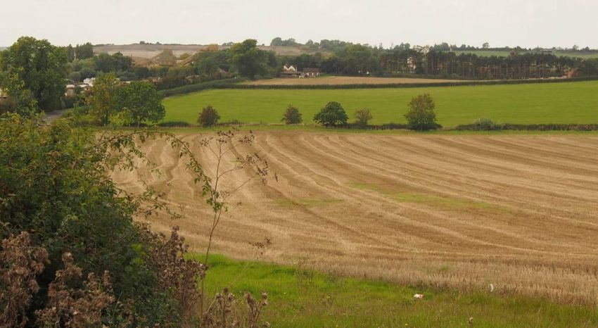
Greensand Country Landscape Partnership, Historic Environment Characterisation 264.2.4 HECZ 2.1: Potsgrove Farmlands Description This HECZ is located in the south-west part of the Greensand Country, between the heart of the Woburn Abbey estate and the A5. It includes the hamlet of Potsgrove, and Battlesden Park. It is a landscape of late C.16th- mid C.18th enclosure, re- organised in places by the Duke of Bedford, and with some more recent field boundary loss. There are long views across arable fields, towards parklands and woodlands/ plantations beyond this HECZ. The hamlet of Potsgrove now lies on a dead-end road, following the re-design of Battlesden Park, which cut off the road south from the village. Potsgrove contains some Duke of Bedford estate cottages, as well as a church and manor farm. Evidence survives of medieval moated sites, including one which is a Scheduled Monument. Field Patterns Good survival of late C.16th-mid C.18th enclosure. Extensive parkland (Battlesden) and parkland-influenced landscape. View north-west from near Hill Farm Archaeological/ Historic Environment Components (See Appendices for fuller descriptions) Historic Environment Character Area (HECA): 2 Archaeological Character Areas (ACAs): 17 Rural Built Environment Character Areas (RBECAs): 12 Historic Landscape Character Areas (HLCs): 62 Greensand Country Landscape Partnership, Historic Environment Characterisation 27
You can also read