Los Angeles Community Risk Assessment - RADAR
←
→
Page content transcription
If your browser does not render page correctly, please read the page content below
Los Angeles
Community Risk Assessment

  Research Alliance for Disaster & Risk Reduction
                   January 2016

                                                    1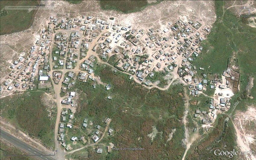
Research Alliance for Disaster & Risk Reduction (RADAR)
Department of Geography & Environmental Studies
University of Stellenbosch
January 2016

This report has been made available to the community leaders of Los Angeles, the Councillor
of Ward 19 in which Los Angeles is situated, Sub-council 21, City of Cape Town Disaster
Management, the City of Cape Town Human Settlements Department, Cape Nature and
stakeholders named within the report.

For a copy of this report please contact Patricia Zweig of RADAR at Stellenbosch University on
021-808-9282 or email patriciazweig@sun.ac.za.

                                                                                            2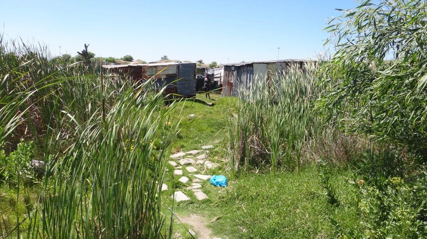
Acknowledgements
On behalf of the University of Stellenbosch we would like to thank all the members of the
Los Angeles community who participated in and contributed to this risk assessment. We are
also indebted to several key role-players who assisted with the planning of the assessment
and provided valuable additional information. Although they are many, we would like
especially to mention a few:
Granville Pietersen – City of Cape Town Disaster Management Centre: Area North
Stanford Dasheka – Community leader of Los Angeles settlement
Hilton Scholtz – Manager City of Cape Town Human Settlements Network: Transport
Teboho Maliehi – Conservation Manager Driftsands Nature Reserve, Cape Nature
Raymond Mtati – Community leader of Green Park settlement (also located in Driftsands
Nature reserve)
We are particularly grateful to all the representatives of the City of Cape Town and Provincial
departments who attended the discussion session held in Los Angeles on 19 November
2015.
Our thanks also to all the Los Angeles community members who participated in the
community workshop held in Lamla Crèche in Los Angeles settlement on 18 November 2015
who later guided the trainees on their transect walks and contributed to the stakeholder
discussion session held on 19 November 2015.
We hope that this brief risk assessment will provide a baseline of information on the living
conditions in Los Angeles against which change over time can be measured while
contributing to reducing some of the risks identified.
3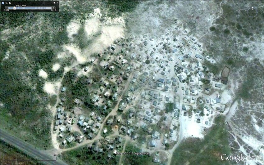
Contents
Acknowledgements ................................................................................................................................ 3
Table of figures ........................................................................................................................................ 5
Executive Summary ................................................................................................................................ 6
1.     Introduction .................................................................................................................................... 8
2.     Methodology................................................................................................................................... 8
     2.1       Preparatory groundwork ......................................................................................................... 9
     2.2       Community Risk Assessment ................................................................................................... 9
     2.3       Reporting ............................................................................................................................... 10
     2.4       Limitations of the study......................................................................................................... 10
     2.5       Ethical Considerations ........................................................................................................... 11
3.     Introduction to Los Angeles settlement ...................................................................................... 12
     3.1       History of the Los Angeles settlement development ............................................................ 14
     3.2       Demographic profile .............................................................................................................. 15
     3.3       Socio-economic characteristics ............................................................................................. 15
     3.4       Current leadership................................................................................................................. 17
     3.5       Housing .................................................................................................................................. 17
     3.6       Services and resources .......................................................................................................... 18
     3.7       Risk profile ............................................................................................................................. 20
     3.8       Development Planning .......................................................................................................... 23
4.     Community Risk and Vulnerability Assessment .......................................................................... 26
     4.1       Lack of electricity ................................................................................................................... 26
     4.2       Crime ..................................................................................................................................... 28
     4.3       Flooding ................................................................................................................................. 29
     4.4       Poor environmental health ................................................................................................... 30
     4.5       Other issues raised ................................................................................................................ 31
     4.6       Support structures for residents of Los Angeles ................................................................... 32
5.     Stakeholder discussion – summary of issues raised.................................................................... 34
     5.1       Health .................................................................................................................................... 34
     5.2       Solid Waste Management ..................................................................................................... 34
     5.3       Safety and security ................................................................................................................ 35
6.     Moving forward: Plotting the road ahead ................................................................................... 35
7.     References..................................................................................................................................... 37
8.     Appendices.................................................................................................................................... 38

                                                                                                                                                           4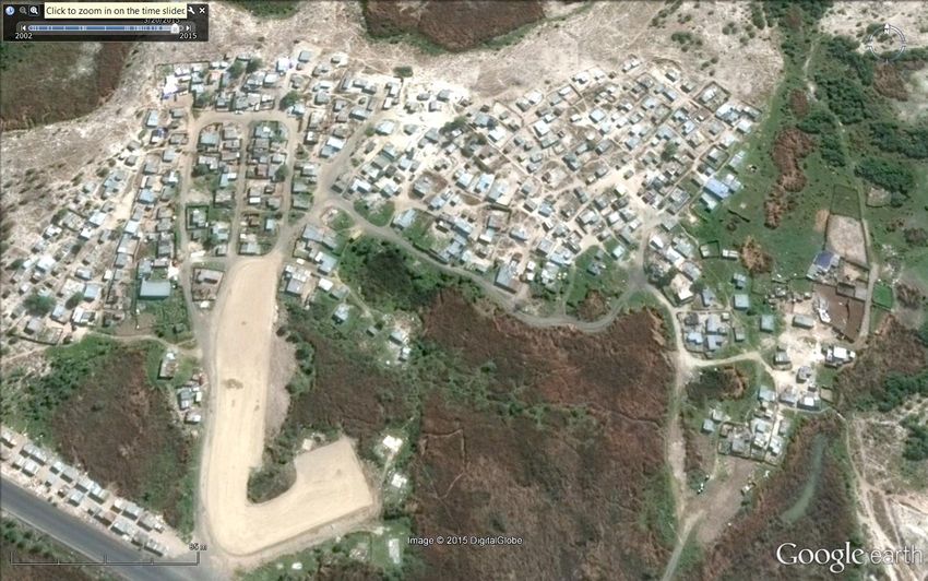
Table of figures
Figure 1    Sub-council area 21 showing location of Los Angeles ....................................................... 12
Figure 2    Aerial view of Los Angeles within the Driftsands Nature Reserve .................................... 13
Figure 3    Example of small settlement vegetable garden ................................................................ 16
Figure 4    An enterprising chicken seller in Los Angeles ................................................................... 16
Figure 5    Community leader Stanford Dasheka (orange shirt) pictured during workshop .............. 17
Figure 6    Typical rural nature of Los Angeles settlement ................................................................. 18
Figure 7    Porta-potties delivered back to Los Angeles after cleaning .............................................. 19
Figure 8    Typical wetland living environment illustrating dense red beds....................................... 20
Figure 9    Aerial view of the flood platform under construction ...................................................... 21
Figure 10   Flood platform after dwellings relocated ......................................................................... 22
Figure 11   Planning diagram of proposed Driftsands development .................................................. 25
Figure 12   Crime hot spots identified in Los Angeles ......................................................................... 29
Figure 13   Refrigeration container outside shebeen showing pile of firewood on right ................... 31
Figure 14   Los Angeles settlement 2002 ............................................................................................ 39
Figure 15   Los Angeles settlement 2004 ............................................................................................ 39
Figure 16   Los Angeles settlement 2009 ............................................................................................ 39
Figure 17   Los Angeles settlement 2011 ............................................................................................ 39
Figure 18   Los Angeles settlement late 2015 ..................................................................................... 39

                                                                                                                                     5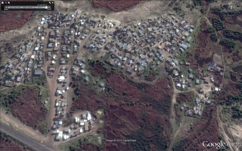
Executive Summary
The South African Disaster Management Act and the National Disaster Management
Framework call for increased efforts to reduce risks developmentally. Disaster risk refers to
the chance of hardship or loss resulting from the interaction between natural or other
hazards and vulnerable households exposed to them. Disaster risk reduction refers to all
policies, actions and initiatives that minimise vulnerabilities and disaster risks, including
prevention, mitigation and preparedness. The South African National Disaster Management
Framework explicitly states that “Disaster risk assessment efforts must actively include the
participation of vulnerable communities and households” (RSA, 2005: 2.1.4).
A community risk assessment is a fundamental step to inform development measures
grounded on local risk dynamics with a view to ensuring the sustainability of interventions
and service delivery programmes. Participatory risk assessment is a methodology that has
been developed to engage communities, using highly participatory approaches in a bottom-
up fashion. It provides insights into how risks are generated and can be reduced. In
employing participatory methods a community risk assessment (CRA) has, as its key tenet, a
concern to put local communities at the forefront of the risk and vulnerability identification
process, thereby allowing ownership and control of the assessment by local residents
themselves. In this way a CRA helps to create a framework for a reciprocal exchange of
information and the development of strategies between local authorities, community
members and other key role players.
Los Angeles settlement, situated in the Driftsands Nature Reserve near Mfuleni is located
within the City of Cape Town. It was identified as a high risk settlement by City of Cape Town
Disaster Management officials, who subsequently supported and facilitated the setting up of
the assessment.
A preliminary scoping of Los Angeles was undertaken by a Stellenbosch University Disaster
Risk Studies coordinator. The community risk assessment followed in November 2015,
beginning with classroom-based lectures and training at the University and culminating in
the participatory field assessment conducted in Los Angeles on 18 and 19 November 2015.
The purpose of the assessment was essentially three-fold:
To empower the Los Angeles community volunteers by involving them in a risk
assessment of their own living environment (CBDRM)
To provide a risk assessment report to key stakeholders and decision-makers with a
view to ensuring effective disaster risk management/disaster risk reduction and to
inform integrated development planning.
To provide field experience to short course participants in community risk
assessment techniques.
6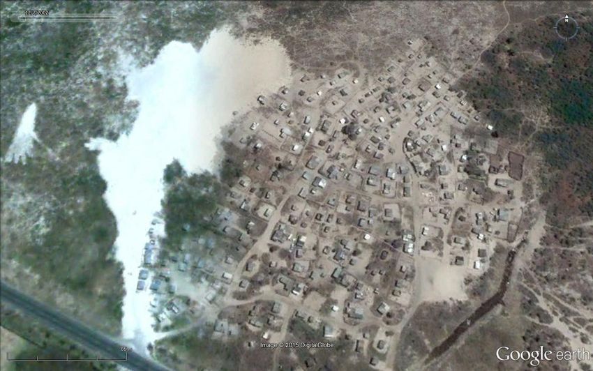
The trainees spent two days in Los Angeles where, in collaboration with community
members employing simple participatory risk assessment tools, they conducted a risk and
vulnerability assessment.
This report is derived from the preliminary scoping exercise, several days of field work and
subsequent additional research. It includes detailed information on the hazards identified by
Los Angeles community members, their perceptions of the root causes of these hazards,
temporal trends and historical changes, recording the physical and social transformation of
the community over time. The report includes time series photographs (See in the appendix)
illustrating the growth of and developmental changes in the settlement over time.
The report concludes with recommendations for the reduction of risk based on the research
findings to inform future risk reduction initiatives and development planning in the area.
These include the following:
Improvement of communication channels between community and role players
Strengthened intersectoral collaboration
Fast-tracking the provision of electricity
Making health facilities/services more accessible to the community
Community support in reporting illegal activities to the City of Cape Town using the
toll-free number 107.
These recommendations are based on discussions held between the community and
external role players and are intended as a guideline for future action.
January 2016
7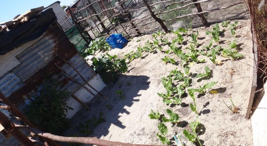
1. Introduction
The South African Disaster Management Act (2003) and the National Disaster Management
Framework (2005) call for increased efforts to reduce risks developmentally. Disaster risk
refers to the chance of hardship or loss resulting from the interaction between natural or
other hazards and vulnerable households exposed to them. Disaster risk reduction refers to
all policies, actions and initiatives that minimise vulnerabilities and disaster risks, including
prevention, mitigation and preparedness. These may typically involve urban planning,
education, health and other social vulnerability reduction measures. Closer cooperation and
confidence-building between at-risk communities and local authority representatives can
improve municipal service delivery as well as strengthen local responsibility for recurrent
risks. Many risks are strongly rooted in social and economic vulnerability along with unstable
sources of livelihood.
A community risk assessment is a fundamental step for informing development measures
grounded on local risk dynamics with a view to ensuring the sustainability of interventions
and service delivery programmes. The key tenet of a community risk assessment is a concern
to put local communities at the forefront of risk and vulnerability identification, thereby
allowing ownership and control of the continued risk assessment process by the local people
themselves. In this way a CRA creates a framework for a reciprocal exchange of information
and strategies between key service providers, development practitioners and local
community members. Anderson and Woodrow (1998: 14) suggest that by assessing its own
capacities a community can build community cohesion through joint action.
Los Angeles settlement, situated in the Driftsands nature Reserve near Mfuleni in the City of
Cape Town was identified as a high risk settlement by City of Cape Town Disaster
Management officials, who subsequently supported and facilitated the setting up of the
assessment.
The purpose of this assessment was essentially three-fold:
To empower the Los Angeles community volunteers by involving them in a risk
assessment of their own living environment (CBDRM)
To provide a risk assessment report to key stakeholders and decision-makers with a
view to ensuring effective disaster risk management/disaster risk reduction and to
inform integrated development planning.
To provide field experience to short course participants in community risk
assessment techniques.
2. Methodology
Community risk assessment is a methodology that has been specifically designed to engage
communities developmentally, using highly participatory tools and methods. It provides
insights into how local risks are generated and can be reduced. It is an approach that aims to
8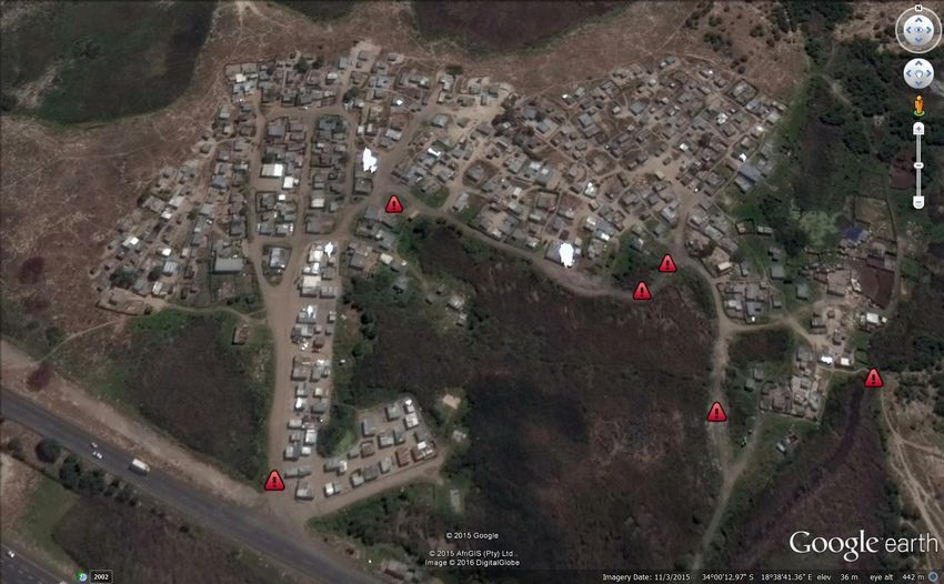
empower the community concerned by involving them in defining problems, in decision-
making, implementation of appropriate activities and evaluation of results and
interventions. A Community Risk Assessment (CRA) can be adapted and applied in numerous
contexts, for a wide range of risks but is always underpinned by a commitment to
participatory engagement with at-risk communities and relevant stakeholders. It
acknowledges that risk reduction efforts will necessarily vary from one community to
another given their unique historical, socio-economic and physical attributes.
Risk assessment is a process that can be effectively employed to determine the nature and
extent of risk by analysing potential hazards and evaluating existing conditions of
vulnerability that could pose a potential threat or cause harm to people, property,
livelihoods and the environment on which they depend.
A participatory risk assessment conducted in collaboration with local community volunteers,
can inform a richer and more insightful understanding, allowing for the co-production and
sharing of knowledge and the generation of deeper and more nuanced understandings of
the local risk and vulnerability profile as well as locally developed coping strategies and
longer term adaptations.
A Community Risk Assessment generally comprises four key phases:
Preparatory groundwork to determine the scope of the risk context and existing risk
reduction initiatives
Conducting a field-based risk assessment in collaboration with the community
Generating appropriate information for integrated disaster risk reduction and
development planning and implementation
Monitoring and recording of subsequent interventions and developments.
2.1 Preparatory groundwork
A preliminary scoping exercise is an essential part of a risk assessment process. Critically it
involves a desktop study of existing information, consultation with a range of stakeholders,
from local authorities, essential services, to local community leaders and organisations. It
also requires a preliminary physical survey of the proposed assessment area. These tasks
were undertaken in September and October 2015 by a Disaster Risk Studies coordinator
from Stellenbosch University.
2.2 Community Risk Assessment
The field assessment was preceded by classroom-based lectures and methodological training
for the risk assessment trainees at the University of Stellenbosch. This was followed by
several days of field work in the Los Angeles settlement working with eleven community
volunteers on 18 and 19 November 2015, while other residents were interviewed during the
course of the transect walk that followed.
The fieldwork component began with a one-day workshop in which the following
participatory methods were employed together with community volunteers:
9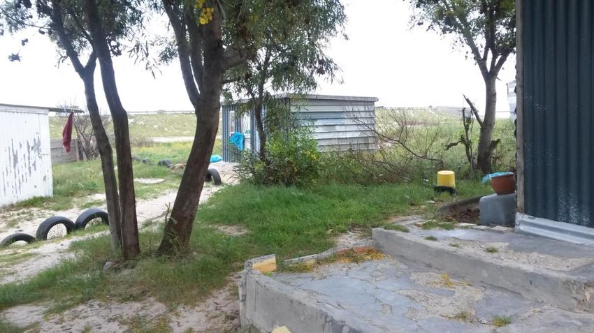
Hazard Identification by local residents to identify the most prevalent hazards
affecting their households or the community as a whole
Hazard Prioritisation in which the hazards identified are clustered according to
broader risk categories. Community members then vote for the risks they feel are
most critical
Problem Tree - A flow diagram showing the relationship between different aspects of
an issue or a problem. It helps to analyze the situation by identifying the root causes,
clarifying the nature as well as the potential impacts of a hazard.
Seasonal Calendar - A tool that is used to identify the periodicity of a hazard
prevalent in a particular community, identifying periods of stress or particular
vulnerability and related social and economic problems or processes
Risk History Table - This records specific disaster events and also helps to build a
sense of change over time and to show how developmental or demographic changes
within and around the community may have increased or reduced specific risks
Venn Diagram - Illustrates significant relationships the community has with
organizations and role players both within and outside the community, identifying
their perceived importance and effectiveness to the community
Transect Walk - This involves traversing the study area extensively with community
members, interviewing additional community members in their homes. This enables
the verification of workshop findings and greater representivity by ensuring that the
perceptions of more marginalized members of a community are included. In this way
trainees were able to observe first-hand the nature of local hazards and to ground-
truth the issues that had been raised. Observations were systematically noted and
photographed, while the spatial nature of key issues was also captured.
2.3 Reporting
This report was compiled for dissemination to all stakeholders in the interests of
transparency and accountability. It is drawn from information compiled from the preliminary
scoping exercise, as well as notes collected during the community workshop, transect walks,
field interviews, recorded observations, and the stakeholder discussion session. It provides a
base-line study against which to measure change over time and thereby will assist in
monitoring progressive risk reduction.
2.4 Limitations of the study
It is important to acknowledge several limitations of this Community Risk Assessment:
Ideally a risk assessment should be conducted over three or more field days to
enable a thorough assessment of all hazards identified. As this was essentially a
training exercise with an allocated time frame of only two field days it was not
possible to conduct a full assessment. This CRA therefore represents an abbreviated
assessment process and covers only the hazards prioritised by the community
members.
10 The assessment was conducted on week days when many economically active
members of the community may have been at work. The group of community
volunteers was not representative of the community demographic, consisting mainly
of women and only two older men. An opportunity for labouring work unexpectedly
attracted many of the men who had planned to attend the workshop. Their opinions
are therefore not represented.
The community leader and many of those who attended the workshop were
relatively new to the settlement and could not provide much historical background
regarding the risk history or changing hazard profile of the settlement over time.
During the fieldwork there appeared to be a division of opinion between older
members and the youth at times. While older members had a longer term
understanding of the dynamics of the settlement, younger members who were
relatively recent arrivals had a different perspective regarding many issues and
tended to be more outspoken.
Many community members, both young and old, found it difficult to understand or
to express themselves in English. Although many of the short course participants
were able to translate between English and Xhosa, the language spoken
predominantly in Los Angeles, much was inevitably lost in translation.
2.5 Ethical Considerations
Several ethical issues had to be considered when undertaking this assessment:
The trainees were accompanied at all times by community volunteers who guided
the researchers through the settlement. This allowed for acceptance of the presence
of outsiders, who were formally introduced and the purpose of the survey explained.
Community members only participated voluntarily and were not promised payment.
Anonymity was guaranteed to all those interviewed
In the interests of transparency and accountability an assurance was made that the
assessment findings would be communicated to key stakeholders, including the
community committee, the Ward Councillor and the relevant City of Cape Town and
Provincial officials.
113. Introduction to Los Angeles settlement
The Los Angeles settlement is situated in Sub-Council 21, a fast-growing area on the eastern
edge of the City of Cape Town metropole that includes Kuilsriver, Blue Downs, Blackheath
Eerste River and some Stellenbosch Farms. According to census data the sub-council,
previously predominantly rural in character, experienced a dramatic population increase of
almost 60% between the 2001 and 2011. Today the sub-council area includes five wards,
namely 11, 14, 17, 19 and 108. Los Angeles today is located within Ward 19 (See Figure 1
below) bordering Sub-council 9 in Khayelitsha from which is divided only by the N2 highway.
Figure 1 Sub-council area 21 showing location of Los Angeles
(Adapted from
https://www.capetown.gov.za/en/stats/2011%20Census%20%20Subcouncil%20Profiles/Subcouncil%2021.pdf)
Situated adjacent to the Old Faure Road, Los Angeles is bordered by Hindle Road to the
North, the N2 National Road to the South, Mfuleni East to the East and the R300 regional
road to the West.
Covering approximately 25 hectares, the Los Angeles settlement forms part of a naturally
low-lying wetland environment that is officially zoned as rural land and physically located
within the Driftsands Nature Reserve. Conserving 658 ha of land, this is the only Provincial
Nature Reserve in the Metropolitan Area.
Despite its conservation status, residents from surrounding areas make use of areas of the
Driftsands Nature Reserve for grazing cattle and for growing and harvesting medicinal plants.
12Figure 2 Aerial view of Los Angeles within the Driftsands Nature Reserve
The land is also utilised for recreational purposes and initiation rites. Houses on the northern
periphery of the Los Angeles settlement are sited near the ridge of the boundary dune, a
concern for conservationists trying to maintain the integrity of the fragile Driftsands
ecosystem.
The Driftsands Nature Reserve was officially proclaimed in 1983, predating the intensive
housing development surrounding it today. The land was registered in the name of the
‘Hospital Trustee’s’ although owned by the Provincial Government of the Western Cape and
was administered by the provincial Department of Public Works. Today, although still owned
by the Province, the reserve falls under the auspices of Cape Nature and, although currently
managed as a nature reserve, now also awkwardly accommodates the formalised housing
area of Sikhumbule as well as the informal settlements of Green Park and Los Angeles.
Driftsands is constituted of an endangered habitat type, Cape Flats Dune Strandveld, and as
such is rated as highest priority by the City of Cape Town’s Biodiversity Network and Open
Space System. Much of the Driftsands reserve forms part of a riparian zone (wetland or
river) situated below the 50-year flood line of the Kuils River, where development is not
permitted in terms of various pieces of legislation, including the Water Act (NWA 36/1998)
and the National Environmental Management Act (NEMA 107/1998 as amended). Despite
this, there has been increasing pressure in recent years, given the rapid growth of the City’s
population, to consider the land on the western side of the reserve for integrated human
settlement. This occurs within the planning context of 1) the N2 Gateway Project, a flagship
housing development of the City of Cape Town that also lies adjacent to the N2 national
road and 2) for the expansion of nearby Khayelitsha located on the other side of the N2.
The future role of Driftsands, in terms of development planning, has therefore been rather
uncertain, pitting conservation priorities against human development needs. It has in the
13interim become increasingly vulnerable to land invasions by those seeking space for informal
dwelling. Today the reserve is surrounded by the low-income suburbs of Delft, Wesbank,
Mfuleni and Khayelitsha. However, other than providing basic housing, the area offers few
other socio-economic opportunities to its growing number of residents.
The City authority and other stakeholders have now committed to finding a solution to the
encroachment of settlements within the reserve, ensuring that it provides appropriate social
and economic benefits to the inhabitants of the city, but with due consideration for
ecological priorities.
3.1 History of the Los Angeles settlement development
Originally established sometime around 1994/5 the settlement began with only three
informal structures and grew gradually, with the first settlers initially collecting water from
the Driftsands settlement. According to the current community leader, Mr Standford
Dasheka, the name of the settlement is derived from the words “lost angels”, a reference to
the first settlers who were perceived by outsiders as peace-loving invaders of the bushy
wetland area. These early settlers came predominantly from the nearby Driftsands
settlement, but also from other crowded areas of the City, such as Langa and Nyanga.
Several families who had originally fled the Crossroads crisis in the late 1980s, when battles
between warring factions forced the relocation of many people, eventually settled in Green
Park and then in this quiet area too, while some of the Crossroads leaders settled in the
nearby Driftsands settlement where streets bear their names to this day (Mtati personal
communication, 26 October 2015).
In the first few years residents of the small settlement had several run-ins with the police as
well as the anti-land invasion unit. The city at that time had a zero-tolerance policy and
would allow no settlement on the land. From 2000 onwards, however, as the population
increased significantly the City and Cape Nature began to explore alternative solutions,
seeking a strategic way forward.
The density of dwellings gradually increased and the first recorded fire occurred in Los
Angeles in 2003, burning down several dwellings. This was followed soon afterwards by the
first account of severe flooding in the settlement. In response to flooding many people
relocated away from the wetland and began to settle higher up on the dunes behind the
settlement. From 2004 the city sought to reduce risk in the settlement with community
support.
Los Angeles was formally recognised as a settlement by the City of Cape Town in 2006.
Around this time the first toilets and taps were installed and negotiations began around the
acquisition of the land by the City to enable the provision of better services and longer term
development planning. Cape Nature had planned to develop tourism and environmental
education infrastructure on the land. However, according to various people interviewed, but
not verified by documental evidence, Cape Nature’s failure to action projected
developments within a stipulated period of time resulted in the settlement becoming eligible
instead for upgrading and development.
14In advance of proposed development, in 2010 COURC, a housing NGO, in collaboration with
the city and with the assistance of settlement dwellers undertook an enumeration survey,
recording the location of dwellings using hand-held GPSs. The portion of farm land on which
the settlement is located has subsequently been surveyed with the intention of transferring
Portion 1 (of Portion 84/Farm No. 544) to the City of Cape Town. This required the
undertaking of an Environmental Impact Assessment, due to the sensitive ecological nature
of the land, which was duly completed. However, the slow pace of development, which has
involved extensive debates about how best to accommodate conflicting developmental
concerns, namely conservation versus human development, resulted in repeated community
protests since 2013.
In recent years severe flooding has occurred several times in the settlement, with some
residents having to be accommodated in a nearby community hall, while others relocated to
the boundary of the settlement, encroaching further into the reserve. In 2013/14 a TB
outbreak occurred in the settlement prompting the search for a more effective solution to
those living in perpetually damp and wet conditions.
3.2 Demographic profile
In 2010, when an enumeration of Los Angeles was undertaken by the Community
Organisation Resource Centre (COURC), a housing NGO, some 375 structures were counted.
They were home to roughly 870 residents who constituted 327 different families. During the
scoping exercise for this risk assessment, the community leader claimed that five years later
this number is now closer to 550, although when approached the City of cape Town’s most
recent official count was 436 structures, and this after a number of recently constructed
additional dwellings had been removed by the Human Settlements department. Thus, one
can assume a population of over 1000 people (working on even a basic estimate of 3 people
per household). At the time of the COURC survey almost 80% of residents in Los Angeles
were younger than 36 years of age, while 41% were under 18 years, illustrating that the
settlement generally has a very young demographic. In the survey, most household heads
also fell within 18-35 year category while almost 60% of them were male.
3.3 Socio-economic characteristics
There are reportedly (CRA workshop) very high levels of unemployment among settlement
residents, with many managing with only casual or temporary employment. In light of this it
is not surprising that the 2010 COURC survey found that 44% of Los Angeles residents were
receiving some form of state welfare grant, the majority for child support, but there were
also nine people drawing pensions and eleven claiming disability grants. Given the
predominantly young demographic of the settlement there is also presumably a large
number of school-going children.
15Ironically, despite the contested nature of the land ownership which is delaying the provision of better services, the Driftsands Nature Reserve is major employer of local residents, particularly for the cutting of reeds. There are very few other informal businesses in the settlement, with one large spaza run by the community leader, and only two shebeens which are central to life in the settlement as they both employ local residents. Many young men were seen to be helping out at one of the shebeens during the transect walk. Several residents recycle plastics for a meagre income, while enterprising others, for example, slaughter, cook and sell chickens (See Figure 5 below). Many residents grow vegetables for household consumption, while some also keep livestock. A large livestock kraal is located on the North-eastern side of the settlement. Figure 3 Example of small settlement vegetable garden Figure 4 An enterprising chicken seller in Los Angeles 16
3.4    Current leadership
Although reportedly originally led by a larger committee of founding members, today the
community is led by Mr Stanford Dasheka and a settlement committee of four people
(Daskeka, 7 September 2015). Dasheka, who also owns and runs the large spaza shop
situated near the main entrance, has only led the community fairly recently, but was
instrumental in negotiating with the City and Cape nature for the provision of the flood risk
platform that was constructed early in 2015. The Los Angeles committee has in the past
joined forces with the leadership of the nearby Green Park settlement, located on the other
side of the reserve, in pressing for development and coordinating community protests. In
2009 the Los Angeles leadership began working in partnership with COURC and the Informal
Settlement Network (ISN) to negotiate development options for the settlement. Together
COURC and members of the Los Angeles community conducted an enumeration survey.
There is also reportedly still a remnant of what is referred to as the ‘traditional leadership’
within the community, noted during a workshop exercise.

Figure 5       Community leader Stanford Dasheka (orange shirt) pictured during workshop

Politically, the settlement is located in Ward 19 in Sun-council area 21, a large geographical
area incorporating many other densely populated low-income residential areas. The ward is
currently led Councillor Brenda Claarson from the Democratic Alliance, the party that
currently administers both the City and leads the Western Cape Provincial authority.
According to community members, neither the local councillor, nor a representative of any
other political party has established a strong relationship with the Los Angeles residents. The
councillor reportedly does not visit the settlement.

3.5    Housing
All dwellings located in Los Angeles can be described as ‘informal shacks’, being made
primarily of wood, zinc and other recycled materials. At the time of the COURC survey in
                                                                                            17
2010 there were approximately 2.7 people residing in each dwelling, although over a quarter
of dwellings actually housed more than four people. The settlement is fairly spacious in its
layout, with most dwellings having a small demarcated garden area, giving the settlement a
distinctly rural feel.
Figure 6 Typical rural nature of Los Angeles settlement
3.6 Services and resources
The 2010 COURC survey identified the immediate service delivery needs of the Los Angeles
community. However, despite the provision of services by the City of Cape Town subsequent
to this survey, today only very basic services continue to be provided in Los Angeles due to
the settlement’s location within a conservation area, limiting permanent infrastructural
solutions while also outside of the official jurisdiction of the City of Cape Town.
Approximately 170 households are currently using Porta-Potties in their homes.
These toilets are scheduled for collection and replacement on Mondays, Wednesdays
and Fridays.
There are 57 other non-flush type toilets scattered across the settlement. Reportedly
less than 40 of them are in working order. (Part of this problem is related to the
location of some toilet units within the flooded wetland areas where they have
gradually become inaccessible). The 2010 COURC survey found the ratio of toilets to
residents to be around 1:32.
An Enviroloo, a prototype full-flush toilet, is currently being piloted. It is situated just
behind the community leader’s dwelling. It is kept padlocked and not for general use.
(It was unclear who provided this prototype).
18Figure 7 Porta-potties delivered back to Los Angeles after cleaning
There are 36 standpipes for the provision of fresh water scattered throughout the
settlement. Many dwellings appear to have organised piped water to their own
dwellings.
Although a fire hydrant was originally provided within the settlement, it was later
damaged when knocked over by a truck and has not subsequently been repaired.
Currently there are no legal electricity connections, although the provision of power,
from Eskom, is anticipated in the very near future. Instead many residents connect
informally to power provided by residents from the nearby formalised Driftsands
residential area, for which they pay a monthly fee that exceeds normal electricity
tariffs. The cost of the electrical cable required to run for over 600 metres from Los
Angeles to Driftsands is prohibitive for many residents who therefore remain without
electrical power.
While there are no formal roads in the settlement, recent flood mitigation work has
caused a slight restructuring of the settlement layout, so that it is more organised
than formerly.
Solid waste is collected twice a week, and 2 blue refuse bags are provided to each
household every week.
Although there are two crèches facilities located within the settlement only one appears to
be in operation. Older children from the settlement attend one of several nearby schools,
with the closest being situated in Driftsands. They access the school across a fairly hazardous
rudimentary bridge that has been constructed over the river by residents.
The nearest fire station, clinic and police station are located in nearby Mfuleni.
193.7 Risk profile
Los Angeles is prone to several risks, including fire, flooding and crime. These risks were
evident prior to the risk assessment, and before the community’s perceptions were
investigated. They are discussed very briefly here.
Fire, although a persistent threat associated with informal living conditions is not a major
threat in Los Angeles, with few fire events having been recorded. The low incidence of fire in
the settlement is partly due to the low density of housing and physical layout compared to
other settlements, as well as the year-round wetland environment.
With much of the settlement located in a low-lying wetland area, many homes are prone to
flooding. Due to its location in a proclaimed nature reserve, permanent engineering
solutions to the flood problem are not an option.
Figure 8 Typical wetland living environment illustrating dense red beds
In 2011/12 negotiations began between various stakeholders and the community seeking
solutions to pervasive flooding. The City of Cape Town subsequently found an innovative
engineering solution involving the building of a platform to raise dwellings above the flood
level (See image of the platform in Los Angeles on the cover of this report). This new solution
to flood risk in informal areas located in sensitive ecological areas where permanent and
highly technical solutions are not possible has been pioneered in three settlements within
the Cape Metropole so far, namely Green Park, Los Angeles and Masiphumelele.
Constructed using compacted earth and retaining wall blocks, the platforms effectively raise
and level portions of flood-affected ground, allowing for the re-building of dwellings above
the flood level. This seems to have improved the living conditions of those who agreed to
move to the platforms, while yet others have insisted on remaining in the flood-prone
wetland areas where they continue to be inundated by flood water during the winter rainfall
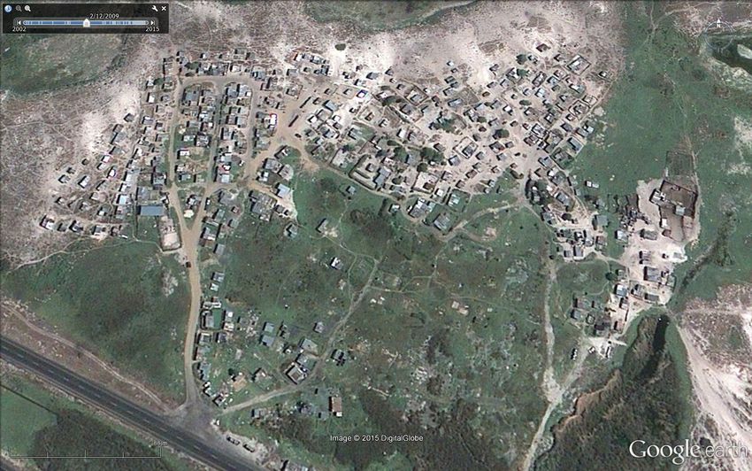
20months. The Google Earth-sourced images below illustrate the reconfiguration of the
settlement over time with the construction of the flood prevention platform occurring early
in 2015.
Figure 9 Aerial view of the flood platform under construction
The construction took several months, beginning with the temporary relocation of 48 flood-
prone dwellings on the southern side of the settlement to an area adjacent to the Old Faure
Road, and concluding with their relocation to the new flood platform early in 2015.
According to Robert Samuels from the City’s Human Settlement department strict rebuilding
criteria were set for the households that relocated to the flood platform. (See cover of
report).
Stipulated building Criteria:
- Residents to maintain fire breaks in between structures of approximately 1 m or 1½m;
- Residents to build within the boundaries of the platform, leaving minimum of 1m to 1½m
right around the dwelling and the plot boundaries;
- As a safety measure to ensure proper access in and out of the platform in case of an
emergency, residents were advised not to encroach onto access roads and passages in
between;
- Committee members, supported by officials, advised residents to “sink” the sidewalls of
their dwelling structures into the platform to prevent water entering the structure from
the outside;
21- Residents were advised regarding the direction of doorway as well as the direction of “roof
fall” to avoid “flooding” caused by another neighbouring structure when it rains;
- Those using dilapidated material were advised to obtain new material from COCT’s
“Relocation Kit” in order to build a structure more suitable for eventual electrification;
- Each resident/beneficiary of a platform plot signed an occupation agreement stating that
the land is government property and cannot be sold or rented out as private property.
Figure 10 Flood platform after dwellings relocated
Crime. Located opposite the Site C informal settlement, a densely populated area of
Khayelitsha, residents say that they experience high levels of crime, with criminals from
Khayelitsha often hiding out in the long reeds from police (See typical reed growth in Figure
8 above).
Several cases of child rape have occurred among the reeds over recent months resulting in
so-called ‘mob justice’ prevailing, with known criminals being attacked by community
members in the absence of police. While the reeds have been cut back in places to reduce
crime risk, the location of the settlement in an ecologically fragile wetland area poses a
problem in terms of limited allowable changes to vegetation cover.
According to settlement dwellers the reeds were not originally much of a problem.
Presumably nutrient-rich water from the settlement has led to the subsequent proliferation
of the reeds, which have now become a crime hazard, a place where criminals hide out and
crimes are committed – residents spoke of having even found dead bodies in the reeds.
Illegal dumping occurs on a regular basis, generally by outside contractors who see informal
settlements as easy dumping grounds. Although some community members make use of
22discarded rubble to raise the floor levels of their dwellings to prevent flooding, the unsightly
piles of unused rubble is a source of contention for others and poses a public health risk.
3.8 Development Planning
The Urban Structure Plan (USP) for the Cape Metropolitan Area was declared almost two
decades ago in February 1996, in terms of Section 37 of the Physical Planning (Act 125 of
1991, as amended). The principal aim of the USP was to guide future development of the
various urban areas in the Peninsula. According to a report by Laros et al regarding possible
development in the Driftsands Nature Reserve
“Where proposed development differs from what is envisaged by the Urban
Structure Plan an amendment or consistency ruling is required by the
relevant Local and Provincial authorities. In the case of Driftsands, while the
Kuils River flood plain (on the eastern side of the Reserve) is clearly
designated ‘Nature Area’ according to the Urban Structure Plan, the
remainder of the Reserve is designated ‘Urban Development’” (2005:7).
Driftsands poses a unique developmental problem, presenting a conflict of interests
between key role players. The City, as the governing authority for the area, is challenged to
accommodate both biodiversity concerns and human settlement planning needs. These
clashes are described briefly below:
The Metropolitan Spatial Development Framework identifies the Driftsands area as
part of the regional green corridor, constituting the Metropolitan Open Space System
along the Kuils River. A regional study conducted by Cape Action for People and the
Environment (C.A.P.E.) indicates that Driftsands is home to a single vegetation type
(known as a Broad Habitat Unit) called the Cape Flats Fynbos/Thicket Mosaic. Found
almost exclusively within the City of Cape Town boundary, this type of vegetational
mix is virtually unique to the city (Laros et al 2005).
In terms of the government’s Breaking New Ground housing policy, and in alignment
with the City of Cape Town’s own spatial planning related to the existing N2 Gateway
Project, Driftsands is calculated to be able to accommodate some 8,000 low-income
households, including those already residing in Los Angeles and Greenpark informal
settlements (Laros et al 2005).
Thus, development planning for both Los Angeles and nearby Green Park settlement has
been slow and arduous, in the search for developmental outcomes acceptable to all parties.
Currently the settlement is in the process of being subdivided from the Driftsands Nature
Reserve, becoming the property of the City of Cape Town. Although the delineation of a
fencing boundary was approved in June 2014, the boundary lines have been rigorously
debated. Unemployed members of the Los Angeles and nearby Green park community (also
located within the reserve) will be enlisted as labourers to erect the boundary fence.
Although the process of de-proclaiming the land was intended to take 18-24 months, the
original deadline expired sometime in 2014 and the long and protracted process has not yet
been completed.
23Although formal housing development is proposed for Los Angeles sometime in the future,
this is contingent on the completion of all the land processes required (See bullets below). In
2006 a City of Cape Town media release (N0 166/2006) announced that housing was being
considered for informal settlement dwellers currently living Green Park and Los Angeles (See
in appendix), with 2000 housing units proposed between the two areas. The provision of
housing is intended to (a) reduce flooding and (b) rehabilitate the wetlands. According to a
letter from Seth Maqetuka, dated 18 August 20141, the process of housing development was
contingent on two processes that were calculated to take four to six months to complete:
De-proclamation of the proposed development area
Transfer of land from Provincial Public Works to the City of Cape Town
These processes have been significantly delayed and upon enquiry it was not possible to
source any preliminary housing layouts from the City. However, formal housing may not be
the panacea anticipated, as some households may not qualify for housing for several
reasons, including owning property elsewhere or having previously received a housing
subsidy, while the number of houses projected may not be able to accommodate those not
enumerated in the 2010 survey when the housing need was estimated. As such, the
allocation process may be controversial and further marginalise any ineligible residents.
The diagram on the following page was received from the City of Cape Town Human
Settlements Department in October 2015. It clearly illustrates the fencing line (thick orange
line) that is proposed to restrain access to and thereby maintain the integrity of the
Driftsands Nature Reserve. This will be erected employing residents of the settlements of Los
Angeles and Green Park, following de-proclamation of the land, subdivision from the nature
reserve, and transfer of ownership from the Western Cape Provincial Government to the
City of Cape Town.
The section of the report that follows details the findings of the field-based participatory risk
assessment undertaken in November 2015.
1
The community leader produced this letter during an interview.
24Figure 11 Planning diagram of proposed Driftsands development
254. Community Risk and Vulnerability Assessment
This section describes the findings of the field work component of the risk assessment
undertaken in Los Angeles settlement.
During a hazard identification and prioritisation exercise conducted at the commencement
of a community workshop held with volunteers from Los Angeles, several key hazards were
identified, namely the lack of electricity, which was unanimously prioritised, and the
escalation of criminal activities and environmental health related to the wetland conditions.
The section below describes and discusses these hazards in detail. After being raised during
the risk assessment workshop and subsequently verified among community members during
the transect walk of the settlement conducted on Thursday 19 November.
4.1 Lack of electricity
The prioritisation of the lack of electricity provision by settlement members was somewhat
anticipated prior to conducting the risk assessment. This was due in part to the spate of
recent protest action by members of the Los Angeles community reported in the media
regarding the lack of electricity provision, It was also because of the recent death of a
married father of three children, known to most members of the community, due to
electrocution that occurred while he was repairing an illegally connected power supply while
standing among the reeds. The subject was discussed and debated at length during the
stakeholder discussion session without any heated confrontation or politicization, while the
lived experience of life without electricity was emotively described by several of the older
women. The table below summarises the issues related to the lack of electricity raised by
community members and describes the consequences for households.
Table 1 Factors associated with lack of electricity
Problem identified Consequences Other comments
Provision of Illegal Cost of electrical cable is Mothers insisted that they have
connections to the excessive, requiring lengths to allow for this cost as power is
nearest formal area of of 600m or more to reach so important to them. Those who
Driftsands is costly the nearest source. have little or no regular income
cannot afford this luxury and use
other forms of lighting, heating
and cooking.
Illegal sources of The cost of electricity The sale of electricity to informal
electricity are very purchased illegally from settlement dwellers is currently a
expensive formal houses in Driftsands mode of income generation for
prohibits many from many poor households living in
pursuing this option. more formalised areas.
Supply from illegal Although informal dwellers Community members insisted
sources is intermittent pay for electricity they have that they pay around R300 each
and out of the control no control over its supply, time to the supplier. However, if
of the informal which is often interrupted the supplier runs out before the
dwellers who are when the suppliers exceed paid-for share has been used they
paying for it. their own electricity supply. have powerless and must just pay
25This often results from again.
providing too many
informal households, and
their own backyard dwellers
with power.
Illegal connections pose Due to the wetland nature Electrocution is a constant threat.
danger of electrocution of the Los Angeles Community members are aware
settlement, electrical cord of the dangers but say they have
is frequently laid across wet no choice because they need
or waterlogged areas and power. Pieces of carpet are
across pathways, posing placed over cables crossing paths
threat of electrocution. to protect against electrocution,
People with no electrical especially to barefoot children
knowledge are installing playing around the settlement.
home-grown electrical
supply, resulting in poorly A mother explained that she does
insulated and dangerous not have an electricity connection
connections and unearthed herself, fearing for the safety of
power supply. her young child. Her neighbour
recently asked permission to lead
a cable through her yard. She is
conflicted as she cannot deny a
neighbour access to power.
Criminals steal Criminals often steal After spending large amounts of
electrical cables electricity cable, which is family income, saved over several
highly sought after and easy months, to buy electricity cable
to sell, especially during the this is heart-breaking for
night, under cover of households. Community
darkness. members say theft of cable is
increasing.
Lack of electricity Small business The community leader runs a
undermines development is not an large spaza shop in the
opportunities for self- option without power settlement, but cannot sell cold
employment supply. People described goods due to the lack of
businesses they want to electricity. Thus, lack of electricity
start once electricity supply denies possible income
arrives. generation, particularly for young
people with business ideas.
School homework For school-going children Particularly in winter months
affected the lack of power for during the long dark hours.
lighting at night has
implications for completing
school work.
Nutritional implications Cooking done quickly to This has consequences for
save fuel, using open fires, household nutrition by limiting
gas or paraffin stoves. food options.
Exacerbates crime risk The settlement is unlit at Use of communal ablution
night, making movement facilities is generally avoided after
after nightfall unsafe. dark.
27It is clear that the lack of electricity provision in Los Angeles settlement is negatively
impacting on the quality of life of residents in a variety of ways and generating other risks
such as crime and unemployment.
4.2 Crime
The issue of crime was raised frequently by community members during the risk assessment,
receiving the second highest number of votes during the hazard prioritisation exercise
undertaken at the beginning of the workshop. Crime is said to be more prevalent over the
months of November and December when those who are employed receive their holiday
bonus. At such times not only are alcohol-induced crimes more likely, but those receiving
bonuses become more vulnerable to theft, robbery and assault themselves becoming targets
for criminals. Perhaps anticipating this spike in criminal activity, police are apparently more
visible during these months. There is also an increase in robbery during the coldest winter
months, when opportunities for work are reduced and household incomes severely strained.
The natural environment is also said to be a critical crime risk driver. Wetland reed beds,
that have reportedly grown significantly since the settlement was first established though
this could not be verified, create hiding places for criminals. Community members described
the gradual escalation of crime over time, generally perpetrated by criminals operating from
the reeds. Crimes range from petty theft to muggings, physical assault and rape, most
recently involving several child victims. Murders were also reported, with bodies reported to
have been found amongst the reeds.
Most crimes are believed to be perpetrated by criminals emanating from outside the
settlement, particularly from nearby Site C, an area of Khayelitsha located on the other side
of the N2 highway. Younger members of the community feel that the consequences of
rampant unemployment, particularly among the youth, results in boredom leading to
teenage pregnancies, drug abuse and gangsterism, which drive up the level of crime. The
table below details crime risk as described by members of the community.
Table 2 Crime risk in Los Angeles
Problem identified Consequences Other comments
Police do not patrol and Pervasive level of fear of Recently when a man was found
seldom respond to calls criminal activity among electrocuted during the night, his
for assistance. Say they community members. It body had to be removed from the
lack adequate patrol is accepted that police reeds by community members
vehicles. will not respond, themselves when police would
particularly at night. not assist.
Criminals attack from People frequently Children are particularly
hiding places in reeds ambushed from hiding vulnerable. Several recent rape
places in reeds, often cases have involved child victims
located along major driving up residents’ concerns to
paths (See Figure 14). clear the reeds.
Criminal activities Stolen goods and dead Adds to community members’
28You can also read