WORKING PAPER 1 INVENTORY OF EXISTING CONDITIONS AVIATION DEMAND FORECAST - Final Draft - Casper/Natrona County International Airport
←
→
Page content transcription
If your browser does not render page correctly, please read the page content below
WORKING PAPER 1
INVENTORY OF EXISTING CONDITIONS
AVIATION DEMAND FORECAST

Airport Master Plan Update

Prepared for:

Casper/Natrona County International Airport
Board of Trustees
Casper, Wyoming

Final Draft

March 2014
Version 3.0
Page Left Blank Intentionally
Casper/Natrona County International Airport
                                                                                                                          Airport Master Plan Update

Table of Contents

CHAPTER 1 INVENTORY OF EXISTING CONDITIONS ............................................................. 1-1
  1.1      BACKGROUND ............................................................................................................. 1-2
  1.2      AIRFIELD FACILITIES ................................................................................................... 1-4
  1.3      LANDSIDE FACILITIES ................................................................................................. 1-7
     1.3.1       Roadways ............................................................................................................... 1-7
     1.3.2       Rail.......................................................................................................................... 1-7
     1.3.3       Parking .................................................................................................................... 1-7
     1.3.4       C/NCIA Business Park ............................................................................................ 1-7
     1.3.5       Foreign Trade Zone .............................................................................................. 1-10
  1.4      PASSENGER TERMINAL BUILDING .......................................................................... 1-11
  1.5      SUPPORT FACILITIES ................................................................................................ 1-15
     1.5.1       Air Traffic Control Tower ....................................................................................... 1-16
     1.5.2       Customs and Border Protection ............................................................................ 1-17
     1.5.3       Aircraft Rescue Firefighting ................................................................................... 1-17
     1.5.4       Airport Maintenance Facility .................................................................................. 1-17
     1.5.5       Fuel Facilities ........................................................................................................ 1-18
     1.5.6       Utilities .................................................................................................................. 1-18
     1.5.7       Fixed Based Operators ......................................................................................... 1-18
     1.5.8       Aircraft Hangars .................................................................................................... 1-19
     1.5.9       Air Cargo ............................................................................................................... 1-19
  1.6      AIRPORT ENVIRONS.................................................................................................. 1-20
     1.6.1       Land Use/Zoning ................................................................................................... 1-20
     1.6.2       Socioeconomic/Demographic Data ....................................................................... 1-20
  1.7      ENVIRONMENTAL DATA ............................................................................................ 1-22
     1.7.1       Endangered Species/Flora/Fauna/Essential Fish Habitat/Migratory Bird Act ......... 1-24
     1.7.2       Hazardous Materials, Pollution Prevention, and Solid Waste ................................ 1-25
     1.7.3       Historic, Architectural, Archaeological, and Cultural Resources ............................ 1-26
     1.7.4       Water Quality ........................................................................................................ 1-26
     1.7.5       Wetlands ............................................................................................................... 1-27
     1.7.6       Wildlife Hazard Assessment .................................................................................. 1-28
CHAPTER 2 AVIATION FORECASTS ......................................................................................... 2-1
  2.1      THE REGIONAL BASE FOR AVIATION ACTIVITY ....................................................... 2-2
     2.1.1       Identification of the Air Trade Area and Population.................................................. 2-2
     2.1.2       Air Trade Area Demographic and Economic Conditions .......................................... 2-3

FINAL DRAFT Inventory                                                i                                                      March 2014 Ver 3.0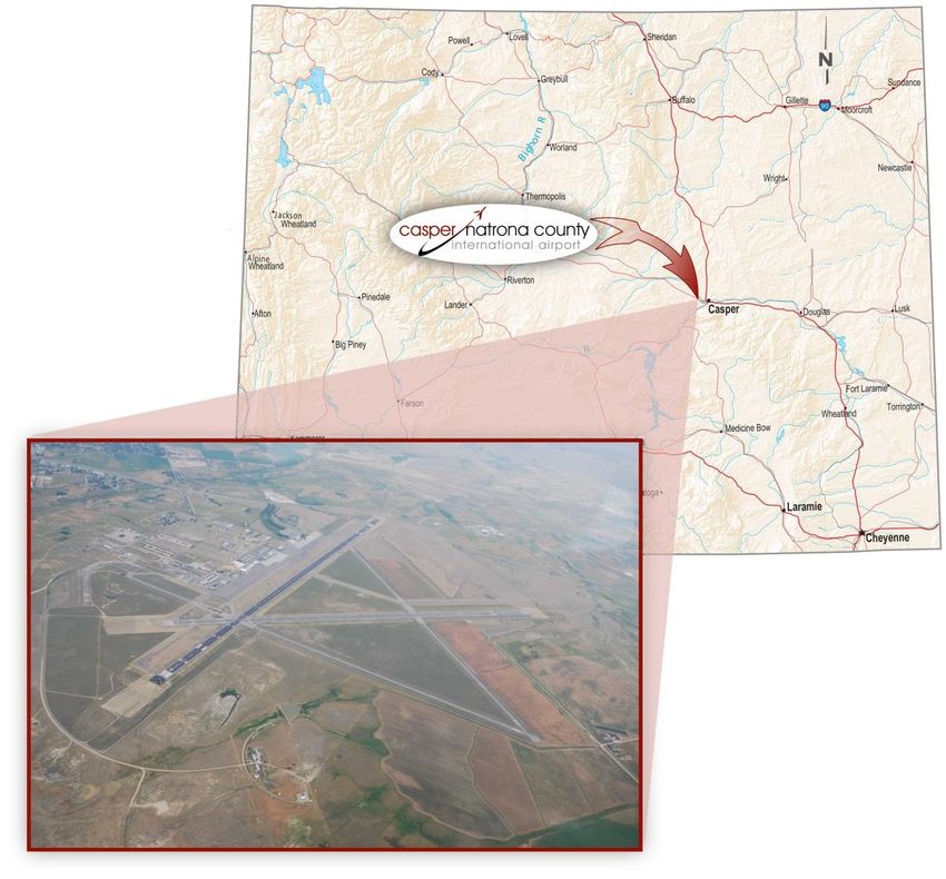
Casper/Natrona County International Airport
                                                                                                                    Airport Master Plan Update

  2.2     HISTORICAL PASSENGER ACTIVITY .......................................................................... 2-8
     2.2.1      Historical Enplaned Passenger Activity ................................................................... 2-8
     2.2.2      Monthly and Other Seasonal Trends ..................................................................... 2-10
     2.2.3      Airlines Providing Service ...................................................................................... 2-11
     2.2.4      Current Flight Schedule......................................................................................... 2-11
  2.3     SIGNIFICANT FACTORS INFLUENCING PASSENGER AIR SERVICE ..................... 2-12
     2.3.1      Location and Other Characteristics of Regional Airports ....................................... 2-12
     2.3.2      Airport Efforts to Improve Air Service .................................................................... 2-15
  2.4     PASSENGER FORECAST........................................................................................... 2-17
     2.4.1      FAA Terminal Area Forecast Base Case ............................................................... 2-17
     2.4.2      Alternate Forecast Scenarios ................................................................................ 2-19
     2.4.3      Passenger Enplanement Forecast Summary ........................................................ 2-26
  2.5     AVIATION ACTIVITY DEMAND FORECASTS............................................................. 2-29
     2.5.1      Customs and Border Protection Operations (Reserved) ........................................ 2-29
     2.5.2      Cargo Operations .................................................................................................. 2-30
     2.5.3      Annual Aircraft Operations .................................................................................... 2-32
     2.5.4      Instrument Operations Forecast ............................................................................ 2-36
     2.5.5      Based Aircraft ....................................................................................................... 2-37
     2.5.6      Forecast Summary ................................................................................................ 2-39
  2.6     DESIGN AIRCRAFT IDENTIFICATION........................................................................ 2-40
  2.7     FORECAST COMPARISON ........................................................................................ 2-42

List of Tables

Table 1-1 RUNWAY CHARACTERISTICS ................................................................................... 1-4
Table 1-2 C/NCIA BUSINESS PARK TENANTS ........................................................................ 1-10
Table 1-3 ENVIRONMENTAL RESOURCE CATEGORIES NOT PRESENT ............................. 1-23
Table 2-1 ECONOMIC DATA FOR AIRPORT CATCHMENT AREA ............................................ 2-4
Table 2-2 HISTORICAL GROWTH OF NATRONA COUNTY POPULATION ............................... 2-5
Table 2-3 TOP EMPLOYERS IN NATRONA COUNTY ................................................................ 2-5
Table 2-4 GROWTH IN ENPLANED PASSENGERS ................................................................. 2-10
Table 2-5 FLIGHT SCHEDULE – FALL 2013 ............................................................................. 2-11
Table 2-6 COMMERCIAL SERVICE AIRPORTS IN WYOMING ................................................ 2-12
Table 2-7 DISTANCES FROM CASPER TO COMPETITIVE AIRPORTS .................................. 2-13
Table 2-8 COMPETITIVE AIR SERVICE TO DENVER .............................................................. 2-13
Table 2-9 COMPARISON OF LOWEST ONE WAY FARE TO DENVER ................................... 2-14
Table 2-10 COMPARISON OF FORECAST OF REVENUE ENPLANED PASSENGERS .......... 2-19
Table 2-11 ENPLANED PASSENGER FORECAST BASED ON ECONOMIC SHARE .............. 2-20
Table 2-12 COMPARISON OF HISTORICAL PASSENGERS AND BOOKED PASSENGERS .. 2-21
Table 2-13 FORECAST BASED ON OUTBOUND PASSENGER BOOKINGS ........................... 2-22
Table 2-14 FORECAST BASED ON AIRLINE CAPACITY ......................................................... 2-24

FINAL DRAFT Inventory                                            ii                                                   March 2014 Ver 3.0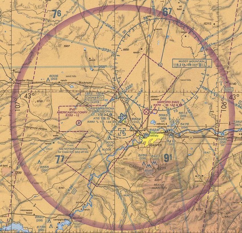
Casper/Natrona County International Airport
                                                                                                                  Airport Master Plan Update

Table 2-15 FORECAST OF FLIGHT DEPARTURES ................................................................. 2-26
Table 2-16 SUMMARY OF ENPLANED PASSENGER FORECAST .......................................... 2-28
Table 2-17 INSTRUMENT OPERATIONS FORECAST.............................................................. 2-36
Table 2-18 FORECAST SUMMARY ........................................................................................... 2-39
Table 2-19 FORECAST COMPARISON ..................................................................................... 2-42

List of Figures

Figure 1-1 AIRPORT VICINITY MAP............................................................................................ 1-3
Figure 1-2 AIRPORT LAYOUT ..................................................................................................... 1-5
Figure 1-3 PCI MAP 2013 ............................................................................................................ 1-6
Figure 1-4 LANDSIDE LAYOUT ................................................................................................... 1-9
Figure 1-5 TERMINAL AREA ..................................................................................................... 1-14
Figure 1-6 SUPPORT FACILITIES LAYOUT .............................................................................. 1-15
Figure 1-7 AIRSPACE DIAGRAM .............................................................................................. 1-16
Figure 1-8 AIRPORT LANDUSE DRAWING .............................................................................. 1-21
Figure 1-9 AIRPORT DRAINAGE DRAWING............................................................................. 1-27
Figure 1-10 AIRPORT WETLANDS AREA MAP ........................................................................ 1-28
Figure 2-1 PRIMARY AND SECONDARY CATCHMENT AREA FOR CPR ................................. 2-2
Figure 2-2 WORK FORCE DISTRIBUTION FOR NATRONA COUNTY ....................................... 2-6
Figure 2-3 HISTORICAL ENPLANED PASSENGERS ................................................................. 2-9
Figure 2-4 PASSENGER SEASONALITY .................................................................................. 2-11
Figure 2-5 AIRPORT OF CHOICE FOR PRIMARY CATCHMENT AREA PASSENGERS ......... 2-15
Figure 2-6 FAA TERMINAL AREA FORECAST – 2012 TO 2032 ............................................... 2-18
Figure 2-7 COMPARISON BASED ON BOOKING DATA........................................................... 2-23
Figure 2-8 FORECAST OF ENPLANED PASSENGERS BASED ON AIRLINE CAPACITY ....... 2-25
Figure 2-9 COMPARISON OF ENPLANED PASSENGER FORECAST ..................................... 2-27
Figure 2-10 AIR CARGO OPERATIONS AND FORECAST ....................................................... 2-31
Figure 2-11 ANNUAL AIRPORT OPERATIONS AND FORECAST ............................................ 2-35
Figure 2-12 BASED AIRCRAFT SCENARIOS ........................................................................... 2-38
Figure 2-13 DESIGN AIRCRAFT ................................................................................................ 2-40

FINAL DRAFT Inventory                                            iii                                                March 2014 Ver 3.0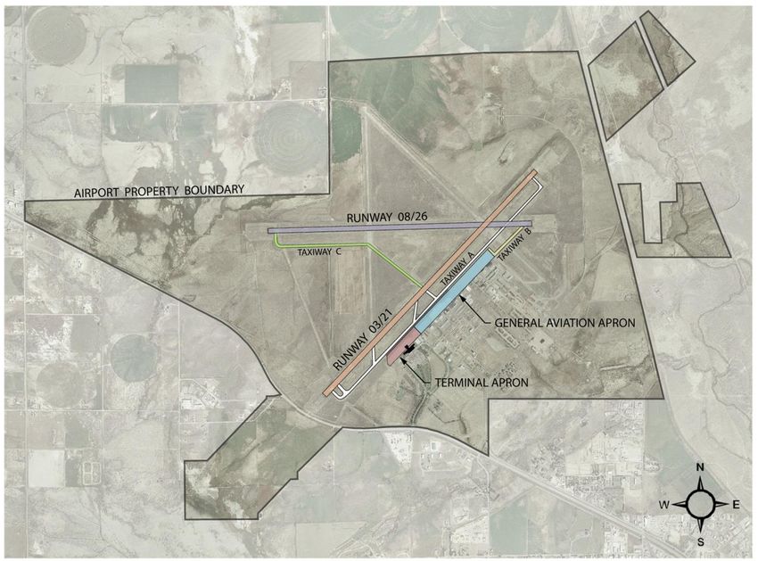
Casper/Natrona County International Airport
                                                                               Airport Master Plan Update

                        Page Left Blank Intentionally

FINAL DRAFT Inventory               iv                                           March 2014 Ver 3.0
Casper/Natrona County International Airport
Airport Master Plan Update
CHAPTER 1
INVENTORY OF EXISTING CONDITIONS
The Federal Aviation Administration (FAA) Advisory Circular (AC) 150/5070-6B, Airport Master
Plans, outlines the necessary steps in the development of an airport Master Plan. The initial step in
documenting the master planning process is the identification of an airport’s existing conditions.
This involves the collection of planning data pertinent to an airport and the area it serves. The
objective of the existing conditions task for the Casper/Natrona County International Airport
(Airport) is to provide background information for subsequent phases of analysis.
The existing conditions information for the Airport has been obtained through:
On-site investigations of the Airport.
Interviews with Airport management, Airport users/stakeholders, Air Traffic Control Tower
staff, and other tenants or interested parties.
The collection and analysis of previous reports and studies, as well as guidelines for airport
development.
This chapter is organized into the following sections:
Background: describes the history, location, and weather conditions of the Airport site.
Additional information is provided regarding other studies and regulations that influence
Airport development.
Airfield Facilities: describes existing runways, taxiways, aircraft parking areas and
navigational aids (NAVAIDs).
Landside Facilities: describes landside access, roadway, and facility data including routes
to and from collector and arterial roadways, on-airport roadways, parking facilities, vehicle
staging and storage areas.
Passenger Terminal Building: describes space allocations by major passenger terminal
functions including their size, condition, use, configuration, and the adequacy of these
facilities under current operating conditions.
Support Facilities: describes other facilities important to the overall operation of the
Airport. It inventories aircraft hangars, air cargo facilities, the Air Traffic Control Tower
(ATCT), Aircraft Rescue and Fire Fighting (ARFF) facilities, the Fixed Base Operator (F
BO), Maintenance, and general aviation facilities.
Airport Environs: describes land use planning; existing off-airport land uses and
future trends; zoning regulations; and socioeconomic/demographic data in the immediate
vicinity of the Airport.
Environmental Data: describes existing recycling and environmental management plans,
noise-sensitive areas, solid waste disposal, drainage, hazardous waste, wetland areas, and
endangered flora and fauna. It also describes any constraints that could affect the future
development alternatives at the Airport.
FINAL DRAFT Inventory 1-1 March 2014 Ver 3.0
Casper/Natrona County International Airport
                                                                                       Airport Master Plan Update

 1.1     BACKGROUND

The Airport is located approximately seven miles northwest of downtown Casper, which is the
county seat of Natrona County (see Figure 1-1). The Airport was constructed as an U.S. Army Air
Base in 1942 and converted into a public airport, Natrona County Airport, in 1949. The Airport was
renamed the Natrona County International Airport, to recognize the addition of Customs and
Border Protection, and in 2007, the Airport was renamed again to better reflect its location to
Casper/Natrona County International Airport (C/NCIA). The Airport is owned by Natrona County.
Natrona County Commissioners appoint a five member Airport Board of Trustees which oversees
the management of the Airport. The Airport Manager and Airport staff are responsible for the day to
day operation of the Airport.

The Airport property encompasses 5,131 acres including: two active runways - Runway 03/21 and
Runway 08/26, two decommissioned runways - Runway 12/30 and Runway 17/35, a flight line with
75 T-hangars and 13 corporate hangars (14 corporate units), the C/NCIA Business Park which
includes a Foreign Trade Zone, the Airport’s historic district, and leased buildings, ground, and
pasture land. The Airport leases land or buildings to more than 300 tenants.

The Airport is designated as a Non-hub Primary Commercial Service airport. Scheduled airline
services by Delta Connection to Salt Lake City, United Express to Denver, and Allegiant Airlines to
Las Vegas operates using Canadair Regional Jets (CRJ) 200s and McDonnell Douglas (MD) 80
aircraft. The Airport has 123 based aircraft.

The climate of Casper can be characterized as semi-arid. Winters are dry, cold and windy, with the
greatest snowfall in April (average of 11.5 inches). Summers are dry and hot with cool evenings.
The mean annual temperature at the Airport is 45.9 degrees Fahrenheit, with an average annual
precipitation of 12.55 inches. The average annual high temperature is 59.7 degrees, and the
hottest month, July, has an average high temperature of 88.5 degrees. The average annual low
temperature is 32.1 degrees, and the coldest month, December, has an average low temperature
of 14.2 degrees.

FINAL DRAFT Inventory                         1-2                                        March 2014 Ver 3.0
Casper/Natrona County International Airport
                                                                                        Airport Master Plan Update

                                          Figure 1-1
                                     AIRPORT VICINITY MAP

Source: National Atlas of the United States, March 11, 2010, http://nationalatlas.gov

FINAL DRAFT Inventory                          1-3                                        March 2014 Ver 3.0
Casper/Natrona County International Airport
                                                                                            Airport Master Plan Update

 1.2     AIRFIELD FACILITIES

The airfield was originally constructed with four runways, varying in length from 8,679 feet to 8,900
feet, to support bomber training for the U.S. Army in 1942. In 1974, Runway 03/21 was extended
to its present day length of 10,165 feet. In 2011, two of the original runways, Runway 12/30 and
Runway 17/35, were decommissioned. Runway 03/21 and Runway 08/26 remain and are
described below in Table 1-1.

The primary runway, Runway 03/21, is oriented northeast-southwest. Runway 03/21 is 10,165 feet
in length, 150 feet in width and classified as a Design Group III runway. Runway 03/21 has a
grooved asphalt surface and a gross bearing weight capacity of 130,000 pounds single-wheel,
170,000 pounds dual-wheel, and 270,000 pounds dual tandem-wheel main landing gear
configuration. Runway 03/21 has High Intensity Runway Lights (HIRL) and 4-light Visual Approach
Slope Indicators (VASI) located at both runway ends. Runway End Identifier Lights (REIL) serve
Runway 21, and a Medium Approach Lighting System with Runway Alignment Indicator Lights
(MALSR) as well as a glide slope and localizer serve Runway 03. Additionally, both runways offer
precision approach runway markings and lighted distance remaining signs.

The crosswind runway is oriented east-west. Runway 08/26 is 8,679 feet in length and 150 feet in
width and is a Design Group III runway. Runway 08/26 is constructed of grooved asphalt with a
gross bearing weight capacity of 85,000 pounds single-wheel, 140,000 pounds dual-wheel, and
260,000 pounds dual tandem-wheel main landing gear configuration. Runway 08/26 has HIRL and
4-light VASI located at both runway ends. REILs serve Runway 26, and a MALSR with glide slope
and localizer serve Runway 08. Additionally, both runways offer precision approach runway
markings and lighted distance remaining signs.

                                               Table 1-1
                                        RUNWAY CHARACTERISTICS

                           Runway                       03/21                   08/26

                          Orientation                           NE-SW                      E-W
                         Length (feet)                          10,165                    8,679
                          Width (feet)                            150                       150
                         Design Group                               III                        III
                         Surface Type                  Grooved Asphalt        Grooved Asphalt

                        Weight Capacity              Single - 130,000       Single - 85,000
                                                       Dual -170,000         Dual -140,000
                                               Dual-tandem - 270,000 Dual-tandem -260,000

                            Lighting                             HIRL                      HIRL
                           Markings                          Precision                Precision
                   Distance Remaining Signs                       Yes                       Yes
              Source: FAA 5010 Master Record, 2012

FINAL DRAFT Inventory                            1-4                                          March 2014 Ver 3.0
Casper/Natrona County International Airport
Airport Master Plan Update
The Airport has three main taxiways, each with connectors, as shown in Figure 1-2. Taxiway A is a
full parallel taxiway with seven connector taxiways to Runway 03/21. It connects to the Terminal
Apron and provides access to Runway 03/21. Taxiway B has one connector taxiway and connects
the Terminal Apron to the threshold of Runway 26. Taxiway C connects Taxiway A5 and Runway
03/21 to the mid-section and west end of Runway 08/26.
Figure 1-2
AIRPORT LAYOUT
Source: RS&H Team, 2013
The primary aircraft parking area is located southeast of Runway 03/21 and Taxiway A, and
includes the Terminal Apron and the General Aviation Apron. The Terminal Apron, on the
southwest section, provides approximately 9,600 square yards of aircraft parking and movement
space for air carriers. The General Aviation Apron, located on the northern section, provides
approximately 144,100 square yards of parking for cargo and general aviation. Both the Terminal
Apron and the General Aviation Apron are constructed of a combination of Portland cement
concrete and asphalt overlay over asphalt concrete.
A Pavement Condition Index (PCI) survey was completed in 2013 (see Figure 1-3). The condition
of all airport pavements that were evaluated in the 2013 PCI ranged from Good to Excellent, with
FINAL DRAFT Inventory 1-5 March 2014 Ver 3.0Casper/Natrona County International Airport
Airport Master Plan Update
the runways being primarily in very good condition. The Terminal Apron is in very good to excellent
condition and the General Aviation Apron is in good or excellent condition. Figure 1-3 graphically
depicts the PCI survey results from 2013.
There are currently eight published approaches at the Airport. Runway 03 and Runway 08 have
Instrument Landing System (ILS) approaches with ½ mile visibility minimums. All four runways
have Area Navigation (RNAV) approaches. Additionally, Runway 03 and Runway 21 have very
high frequency omni-directional range distance measuring equipment (VORDME) approaches.
Figure 1-3
PCI MAP 2013
Source: 2013 C/NCIA PCI Report
FINAL DRAFT Inventory 1-6 March 2014 Ver 3.0Casper/Natrona County International Airport
Airport Master Plan Update
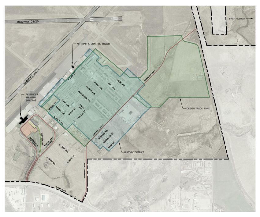
1.3 LANDSIDE FACILITIES
The landside facilities section describes the Airport’s landside access, roadways, rail access,
public, employee and rental car parking, the C/NCIA Business Park, and the Foreign Trade Zone
(FTZ). Figure 1-4 illustrates the location of roadways, railways, parking, the C/NCIA Business Park,
and the FTZ.
1.3.1 Roadways
The Airport is accessed on the south by U.S. Highway 20-26 using two entry points - Commerce
Drive accesses the C/NCIA Business Park and the east and northeast portions of the Airport
property and Airport Parkway accesses the passenger terminal area and flight line buildings. Over
20 other paved Airport roadways provide access throughout the C/NCIA Business Park and to the
flight line.
1.3.2 Rail
The BNSF Railway Class I rail line is located north of Airport property. The Casper Logistics Hub
(CLH) owns 700 acres located between the BNSF rail line and Airport property. CLH provides
transloading, trucking, erecting, storage, warehouse and switching. The transload facility is
managed by CTRAN (Casper Transloading) and is operated by Bighorn Divide & Wyoming
Railroad Inc.
1.3.3 Parking
Automobile parking southeast of the terminal building includes public, rental car, and employee
parking. The public parking lot provided 504 parking spaces for public parking. Short term parking
(0-3 hours) is free of charge and the daily rate is $5 per day for the first 10 days, $4 per day from
11 to 20 days, and $3 per day from day 21 on. In 2012, the parking lot was expanded to the
southeast to include an additional 87 parking spaces. The original parking lot pavement is in poor
condition and received a PCI of 17 in 2013. Per Wyoming Statue 315-5-501(d), the Airport is
required to provide 20% of its public parking spaces free of charge. These spaces are located
along Coffman Drive and a designated area off of Commerce Drive. Thirty-two employee and 97
rental car ready spaces are located northeast of the public parking lot. Fifteen minute parking for
loading/unloading passengers, designated hotel shuttle spaces, and taxicab spaces are available
adjacent to the terminal building on both sides of Airport Parkway totaling approximately 40
spaces.
1.3.4 C/NCIA Business Park
The C/NCIA Business Park is located east and northeast of the terminal building and lies within
Airport property. The C/NCIA Business Park consists of almost 200 acres of land with typical
business park and industrial facilities. Two hundred additional acres are adjacent to the C/NCIA
Business Park for future development. Figure 1-4 shows the location of the C/NCIA Business Park
within Airport property. FTZ 157 is also located within the C/NCIA Business Park (see Section
1.3.5). The C/NCIA Business Park contains 38 businesses (listed in Table 1-2) and 136 buildings.
The businesses represent sectors as diverse as manufacturing, retail, and aviation. The Airport’s
Historic District is part of the C/NCIA Business Park (see Section 1.7.3 for more details). The
C/NCIA Business Park provides vital income to financially sustain the Airport. A majority of the
businesses within the park are non-aeronautical.
FINAL DRAFT Inventory 1-7 March 2014 Ver 3.0Casper/Natrona County International Airport
Airport Master Plan Update
Page Left Blank Intentionally
FINAL DRAFT Inventory 1-8 March 2014 Ver 3.0Casper/Natrona County International Airport
Airport Master Plan Update
Figure 1-4
LANDSIDE LAYOUT
FINAL DRAFT Inventory 1-9 March 2014 Ver 3.0Natrona County International Airport
Airport Master Plan Update
Table 1-2
C/NCIA BUSINESS PARK TENANTS
Intermountain World War II Museum
Apogee Aircraft FAA Control Tower
Records 3740 Jourgensen
3745-B Studer 7710 Fuller Street
3765 Airport Parkway Avenue
Avis/Budget Car FAA Field Sector Intermountain
World War II Museum
Rental Office Threading
3739 Schulte Avenue
3823 Schulte Avenue 8411 Fuller Street 3741 Bell Avenue
Superior Plus
BME Fabrication FAA Storage Building Sport Truck USA
Construction
3746 Esmay Avenue 8033 Fuller Street 7607 Fuller Street
3465 Bell Avenue
Forward Bit Pipe & Wyoming Precast
Chucks Auto Repair Mosquito Abatement
Tool Products
3811 Dame 3874 Dame Avenue
3700-E Allen 7600-B Allen Avenue
Community Fowles Custom
Nalco Fab-Tech, LLC Full Contact Cement
Corrections Cabinetry
3777 Airport Parkway 3817 Esmay Avenue
Airport Property 3770 Allen Avenue
Hertz Car Rental Sage Technical
Con-way Freight Process Fabrication
3812 Jourgensen Service
8315 Werner Street 3600 Schulte Avenue
Avenue Parade Ground
Cowboy High Adventure Race Wyoming Wood ‘n
Trout Transport
Transportation Fabrication Works
3823-A Studer
3395 Allen Avenue 7450 Werner Street 3812 Dame
Evershine Trucking Silver Tip Services
C-Tran
Allen and Commerce 3882 Jourgensen
Airport Property
Drive Avenue
Totally Benign
Enviro Engineering
Reach for A Star Enterprise
7600- A Werner
4250 Six Mile Road 3745-A Studer
Street
Avenue
Source: www.iflycasper.com, 2013
1.3.5 Foreign Trade Zone
Foreign Trade Zone 157 was established on January 29, 1989 within the C/NCIA Business Park
and expanded north to include a portion of the Casper Logistics Hub facility. The zone currently
encompasses 1,476 acres and is shown in Figure 1-4. A FTZ is a specific area where any form of
imported merchandise may be stored, packaged, assembled, manufactured, cleaned, sorted, and
graded without the expense of Customs duties or taxes. While the Airport’s FTZ has not yet been
used, there has been interest by neighboring developers in activating and using the FTZ.
FINAL DRAFT Inventory 1-10 March 2014 Ver 3.0Natrona County International Airport
Airport Master Plan Update
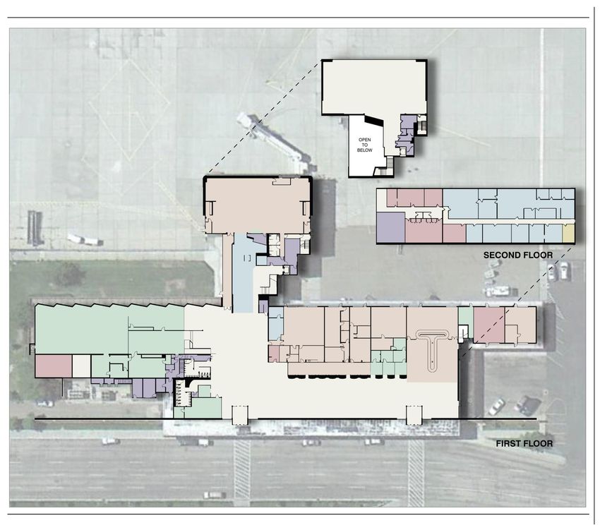
1.4 PASSENGER TERMINAL BUILDING
The passenger terminal building is located at 8500 Airport Parkway, on the south end of Airport
property, south of Runway 03/21. Constructed in 1952/1953 the brick, two story building
encompasses approximately 74,000 square feet. The terminal building was expanded in 1982/83
and remodeled in 2004. As shown in Figure 1-5, the building provides space for the following:
airline ticketing counters, offices, and bag makeup areas; baggage claim and handling areas;
passenger waiting areas; passenger screening; rental car counters; Airport, airline, and
Transportation Security Administration (TSA) administrative offices; room rental; advertising; a
restaurant, gift shop, and lounge; and offices for U.S. Customs and Border Protection (CBP).
Airline ticketing counters are located on the southern side of the first floor of the terminal building.
There are four airline ticketing counter positions. Currently three ticket counters are leased. Airline
Ticketing Offices (ATOs) are located directly behind the ticket counters and have direct access to
baggage makeup areas and the Secured Identification Display Area (SIDA) on the ramp. SkyWest
Airlines ground handles both United Express and Delta Connection flights. SkyWest leases 480
square feet of counter space, 684 square feet of bag make-up, 735 square feet of office space,
and 1,056 square feet of cargo space. Allegiant Airlines leases office space and uses ticket
counter and bag makeup areas on a per use basis.
The baggage claim is served by one baggage belt on the northeast end of the terminal building on
the first floor. The airlines lease 3,200 square feet of common use baggage claim space (public
and non-public).
Three rental car counters serve passengers near the baggage claim on the first floor. Offices for
rental car staff are located behind the counters. The Airport is served by Hertz, Avis, and Budget in
the terminal building, and Enterprise from an offsite location. Hertz has a rental carwash/service
facility in the C/NCIA Business Park at 3812 Jourgensen Avenue, and Avis/Budget has a
carwash/service facility in the C/NCIA Business Park at 3823 Schulte Avenue.
Concessionaires at the Airport include the Airport Gift Shop (Wyoming Trading Company) and Sky
Terrace Lounge. Wyoming Trading Company leases 704 square feet in the southeast portion of
the first floor of the terminal building and offers gifts, snacks, and coffee. Sky Terrace Lounge
leases 1,589 square feet in the southwest portion of the first floor of the terminal building and offers
food, alcohol, and games. An unleased deli and kitchen space of 1,924 square feet is located
adjacent to Sky Terrace Lounge. Additionally, vending machines and an ATM are also located in
the passenger lobby.
The Airport lobby, located on the first floor of the terminal building, provides approximately 112
seats for passengers waiting to go through security or for people awaiting the arrival of
passengers. Public restrooms are located in the southwest side of the lobby adjacent to Wyoming
Trading Company and behind Sky Terrace Lounge.
TSA currently leases 5,680 square feet of space from the Airport. TSA’s screener staff offices are
located on the south end of the first floor of the Terminal building and TSA Wyoming administration
offices are located on the northern half of the second floor. TSA has expanded their lease space
numerous times over the past five years. The Security Screening Check Point (SSCP) is located
on the first floor. The Airport is currently served by two screening lanes at the SSCP. The SSCP is
equipped with two x-ray machines, an AT2 and a RapiScan, one Ceia walk through metal detector,
two explosive trace detectors, and 2 DESKO boarding pass readers. The SSCP area is staffed
with Airport Public Safety Officers during flight times.
FINAL DRAFT Inventory 1-11 March 2014 Ver 3.0Natrona County International Airport
Airport Master Plan Update
The gate hold room is 5,400 square feet post security and provides 169 seats for passengers
waiting to board a flight. Passengers enplane and deplane via one jet bridge at Gate 2 or air stairs
onto the apron from Gates 1 and 3. Restrooms and vending machines are available in the gate
hold room. The exit lane from the gate hold room into the passenger lobby was reduced in size in
December 2013 to 916 square feet.
In 2012, the observation deck on the second floor was reconfigured to be accessible via the gate
holding room for additional space for passengers waiting for flights. The observation deck can
become secured when needed from the gate hold room. When not secure, the observation deck is
open to the general public and offers 5,000 square feet of rental space for events or to view airport
operations.
The Airport Administration Office is located on the second floor of the terminal building. The Airport
Board Room is also located on the second floor directly across from the Airport Administration
Office. The Airport management utilizes approximately 4,000 square feet of the terminal building.
Space for CBP offices is allocated within the terminal building; see Section 1.5.2 for more detailed
information. The building also has a basement, accessed from the south end of the terminal, which
is used mostly for storage and provides a shelter during inclement weather.
FINAL DRAFT Inventory 1-12 March 2014 Ver 3.0Natrona County International Airport
Airport Master Plan Update
Page Left Blank Intentionally
FINAL DRAFT Inventory 1-13 March 2014 Ver 3.0Casper/Natrona County International Airport
Airport Master Plan Update
Figure 1-5
TERMINAL AREA
Source: Airport Records, RS&H, 2013
FINAL DRAFT Inventory 1-14 March 2014 Ver3.0Natrona County International Airport
Airport Master Plan Update
1.5 SUPPORT FACILITIES
The support facilities section describes the location and condition of the various facilities important
to the overall operation of the Airport. These facilities include the Air Traffic Control Tower,
Customs and Border Protection, Aircraft Rescue and Firefighting facilities, Airport maintenance
facilities, fuel facilities, utilities, fixed based operator facilities, aircraft hangars, and air cargo
facilities. Figure 1-6 shows the locations of these support facilities.
Figure 1-6
SUPPORT FACILITIES LAYOUT
Source: RS&H Team, 2013
FINAL DRAFT Inventory 1-15 March 2014 Ver 3.0Natrona County International Airport
Airport Master Plan Update
1.5.1 Air Traffic Control Tower
The Airport’s ATCT is located at 7710 Fuller Street and was constructed in 1954. The tower
building is owned and maintained by the Airport. The Base Building, constructed in 1992, is owned
and maintained by the FAA and land is leased from the Airport. In 2006, a prefabricated building
which houses a backup generator was installed to the west of the Base Building. According to the
December 2012 Condition Assessment and 6480.17 Facility Evaluation Report, the ATCT and
Base Building facility are in fair condition. As part of this master plan study, the facility’s condition,
location, and functional and useful life will be evaluated. If deemed necessary, an alternate tower
site may be evaluated.
Tower operations have fluctuated over the past 10 years, ranging from a high of 48,301 in 2003 to
a low of 35,505 in 2010. The ATCT/Terminal Radar Approach Control (TRACON) is open seven
days a week between the hours of 5:00am and 9:00pm. Controllers are responsible for Casper
Class D airspace, which is defined as the airspace extending upward from the surface up to and
including 7,800 mean sea level (MSL) within a five nautical mile (NM) radius of the defined
coordinates of the Airport. Additionally, these controllers are responsible for directing ground
movement of all aircraft and vehicles on the runway and taxiway system. Figure 1-7 depicts the
airspace surrounding the Airport.
Figure 1-7
AIRSPACE DIAGRAM
Source: www.vfrmap.com, 2013
FINAL DRAFT Inventory 1-16 March 2014 Ver 3.0Natrona County International Airport
Airport Master Plan Update
1.5.2 Customs and Border Protection
The Airport is served by the only Customs and Border Protection Port of Entry in the State of
Wyoming, by one part time agent. The Customs and Border Protection operation at the Airport has
been in existence since 1970. The hours of operation are based on operational requirements and
all aircraft operators must call two hours prior to intended arrival time to arrange service. The
Casper CBP agent clears more than 500 aircraft a year.
The CBP office is located within the terminal building on the second floor. CBP currently leases
215 square feet. Due to space constraints and lack of airfield access in the current location, a new
CBP office is being designed and will be located on the south side of the first floor behind the Sky
Terrace Lounge. The new space will have direct access to the apron south of the terminal building.
1.5.3 Aircraft Rescue Firefighting
The Airport offers ARFF Index B services based on the length of the air carrier aircraft (greater
than 90 feet and less than 126 feet) and the average daily departures of air carrier aircraft.
Determination of the ARFF Index is described within Title 14 CFR, Part 139.315, Aircraft rescue
and firefighting: Index determination. The Public Safety Building, constructed in 1974 to the
northeast of the terminal building, houses police/ARFF staff and equipment. The Public Safety
Building is 8,029 square feet and has three airside bays for ARFF and three landside bays for
police, operations, and structural fire equipment. A control tower on the west corner provides
incident command a view of most of the airfield. Additionally two offices provide space for the Chief
and Assistance Chief. A bunkroom with six beds and living quarters are also located in the Public
Safety Building. The Airport owns a 1995 E-One Titan with a 1,500 gallon water tank, a 2009
Rosenbauer Panther with a 1,500 gallon water tank, and a Becker Fastak 500 gallon premixed
water/foam quick response vehicle. The Public Safety Building is in fair condition; however, it does
not provide adequate space for security functions now required since the attacks of 9/11.
Additionally, the Airport maintains and operates the Wyoming ARFF Training Facility. The Training
Facility, constructed in 1994, is located on Commerce Drive in the northeast part of the C/NCIA
Business Park. The diesel fueled facility offers training to ARFF departments from Wyoming and
out-of-state. The facility is subsidized by a grant from the Wyoming Aeronautics Division to offer
Wyoming firefighters discounted training. The facility is staffed by Airport Public Safety Officers.
The facility has now exceeded its life expectancy and is currently being reviewed by the Airport for
potential replacement, upgrade, or closure.
1.5.4 Airport Maintenance Facility
The Airport maintenance facility is 17,928 square feet and is located along Commerce Drive in the
northeast part of the C/NCIA Business Park. The shop is supplemented by four nearby equipment
storage buildings. The Airport owns and operates a variety of maintenance equipment that is
needed for ground maintenance, pavement and facilities maintenance, general repairs, and snow
removal. The airport maintenance facility houses equipment and maintenance work shops,
including an electrical shop, plumbing shop, carpentry shop, vehicle maintenance area, and
administration offices. These facilities were originally constructed and used by the Casper Army Air
Base. The maintenance facilities are in poor condition and are well beyond their expected life. The
Snow Removal Equipment Facility Concept and Budget Report was completed in December 2013
to evaluate a replacement facility.
FINAL DRAFT Inventory 1-17 March 2014 Ver 3.0Natrona County International Airport
Airport Master Plan Update
1.5.5 Fuel Facilities
The Airport owns and operates a fuel farm located at 7785 Fuller Street near the ATCT. The fuel
farm was constructed in 2009 and contains 120,000 gallons of Jet A, 24,000 gallons of Avgas,
12,000 gallons of unleaded fuel, and 10,000 gallons of on-road diesel. The Jet A tanks are single
wall and the Avgas, unleaded, and diesel tanks are doublewalled tanks with secondary
containment basins provided by a concrete dike. Additionally 5,000 gallons of off-road diesel fuel is
located near the Airport maintenance facility for vehicle fueling and 5,000 gallons of off-road diesel
is located at the ARFF Training Facility for live fire training. A few tenants within the C/NCIA
Business Park also have above ground fuel tanks on their leased premises for their private use.
Fuel is sold to various businesses and individuals including Atlantic Aviation, the rental car
companies, FedEx, Sage Truck Driving School, the Airlines, and Airport staff. The fuel farm is in
excellent condition and is regulated by the Wyoming State Fire Marshall and the Wyoming
Department of Environmental Quality (WDEQ). Atlantic Aviation also has a self-fueling Avgas tank
with 10,000 gallons of fuel on the General Aviation apron.
1.5.6 Utilities
Electricity is provided to all buildings at the Airport by Rocky Mountain Power. The Casper/Natrona
County International Airport water system is a consecutive distribution system from the
City/Regional Systems. The water distribution system was replaced in 1979 and is nearing the end
of its useful life for the underground metal components. Water pressure and quality has frequently
been an issue; therefore, the Central Wyoming Regional Water System Joint Powers Board is
planning for the construction of a new water tank in the footprint of the existing tank in 2014. The
Airport maintains a sanitary sewer system serving all Airport buildings. The sanitary sewer
infrastructure was constructed in the 1940’s. Natural Gas is available throughout the C/NCIA
Business Park and to the terminal building. Phone service is provided by Qwest. In 2012, the
Airport installed fiber optic cable around the business park and to the terminal building.
1.5.7 Fixed Based Operators
The Airport’s full service FBO, Atlantic Aviation, is located in the middle of the flight line on Fuller
Street. Atlantic Aviation leases four multi-storage hangars from the Airport in addition to ramp
space, ground rent, and fuel farm use. Atlantic Aviation provides aircraft parking, heated hangar
space and hangar rentals, cargo and ground handling services, Type I and IV deicing, Jet A,
Avgas, self-serve Avgas, and aircraft maintenance services. Atlantic Aviation leases 64 T-hangars
from the Airport and then subleases the hangars to their customers. The FBO remodeled their
office and pilot lounge facility in 2013, which is in excellent condition. Other FBO facilities are in fair
to poor condition.
Other FBOs providing limited aeronautical services at the Airport include Crosswind Aviation,
Natrona Avionics, M&N Aviation, and Imperial Aeronautical Services. Crosswind Aviation offers
flight instruction with four Cessna 172s, a helicopter, and a Piper Arrow. The company also
provides aircraft rental, ground handling services for Allegiant Air, and aerial photography.
Crosswind Aviation also partners with Casper College to provide courses and flight instruction for
the college’s Associate’s Degree in Aviation. Natrona Avionics offers avionics installation and
repair, M&N provides Part 135 charter services, and Imperial Aeronautical Services offers aircraft
maintenance services.
FINAL DRAFT Inventory 1-18 March 2014 Ver 3.0Natrona County International Airport
Airport Master Plan Update
1.5.8 Aircraft Hangars
As noted in the previous section, the Airport leases 64 T-hangars to Atlantic Aviation. Another 10
T-hangars, located northeast of the Public Safety Building, and two T-hangars located on the north
end of the airfield are owned by the Airport and leased directly to tenants. Currently a 26-person
waiting list exists for these T-hangars. Additionally, the Airport owns and leases 11 corporate
hangars or land for three privately developed hangars along Fuller Street to tenants such as
Atlantic Aviation and FedEx.
1.5.9 Air Cargo
Two air cargo operations are located on the Airport: FedEx and UPS. FedEx’s 13,427 square foot
sorting center, leased from the Airport, is adjacent to Atlantic Aviation at 8094 Fuller Street. Daily
flights from Memphis, served by a Boeing 757-200 or Airbus A300/310 aircraft, provide packages
to the facility where they are then sorted and sent via Cessna Caravans to other airports across the
State of Wyoming, Colorado, Nebraska, or locally by truck. UPS packages are brought by truck to
the Airport for loading onto aircraft. Key Lime Air is contracted by UPS to fly their packages from
Casper to Denver and Steamboat Springs, Colorado. The FedEx cargo facilities are in fair to poor
condition.
FINAL DRAFT Inventory 1-19 March 2014 Ver 3.0Natrona County International Airport
Airport Master Plan Update
1.6 AIRPORT ENVIRONS
This section describes the 2013 Airport Land Use Review, Airport relative zoning regulations which
include an Airport Overlay District, and socioeconomic and demographic data of Casper and
Natrona County.
1.6.1 Land Use/Zoning
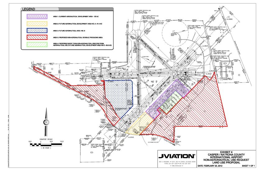
The Airport currently encompasses 5,131 acres. The Airport Land Use Review was completed in
2013 and identified that out of the 5,131 acres, 845 acres contained the runway and taxiway
system, 1,025 acres contained approach areas, 291 acres contained other types of developed
property, and 2,086 acres contained property that has not been developed or is minimally
developed. As illustrated in Figure 1-8, the study suggested that current aeronautical use
encompasses approximately 125 acres (Area 1), some of which is minimally developed. The study
identified three additional areas to be reserved for aeronautical development. Area 2 (81 acres)
and Area 3 (246 acres) currently have no development while Area 4 (64 acres) has existing non-
aeronautical development and was proposed to continue as non-aeronautical in the short term.
Natrona County adopted an Airport Overlay District as part of the county’s 2000 Zoning Resolution
of Natrona County, adopted December 19, 2000, and last updated on December 14, 2009
(http://www.natronacounty-wy.gov). The Airport Overlay District is described as follows: rectangular
area of land beginning 200 feet beyond the end of all runways, 2,000 feet on each side of the
extended centerline of each runway in width by 10,000 feet in length. Any development or change
of land use within this Airport Influence Area must first be reviewed by the Airport’s Board of
Trustees and the Airport Manager for land use compatibility issues.
Natrona County’s zoning designation for the Airport is Planned Unit Development (PUD)
(http://geosmart.casperwy.gov, 2013). A majority of the land surrounding the Airport is zoned
Urban Agriculture with small pockets of various other zoning designations. Adjacent to the
northeast portion of Airport property the land is zoned Heavy Industrial. South of the Airport, zoning
is a mix of Urban Residential, Commercial, and Light Industrial.
1.6.2 Socioeconomic/Demographic Data
Casper is located in central Wyoming within Natrona County. According to the 2010 U.S. Census
(http://www.census.gov, 2013), Natrona County has a population of 75,450 and Casper has a
population of 55,316. Casper was documented to have an average household income of $53,064
in 2011. Casper’s central location makes it a focal point for regional, financial, retail, and medical
services for many Wyoming residents. The Wyoming Medical Center offers many medical services
unavailable in other parts of the State of Wyoming. Casper boasts a stable economy, with a long
history as an oil boomtown and a center for resource development.
FINAL DRAFT Inventory 1-20 March 2014 Ver 3.0Casper/Natrona County International Airport
Airport Master Plan Update
Source: 2013 Airport Land Use Review
Figure 1-8
AIRPORT LANDUSE DRAWING
FINAL DRAFT Inventory 1-21 March 2014 Ver 3.0Casper/Natrona County International Airport
Airport Master Plan Update
1.7 ENVIRONMENTAL DATA
FAA Order 1050.1E, Policies and Procedures for Considering Environmental Impacts, and
5050.4B, National Environmental Policy Act (NEPA Implementing Instructions for Airports),
requires the evaluation of airport development projects as they relate to specific environmental
impact categories by outlining types of impacts and the thresholds at which the impacts are
considered significant. For some impact categories, this determination can be made through
calculations, measurements, or observations. However, other impact categories require that the
determination be established through correspondence with appropriate federal, state, and/or local
agencies. A complete evaluation of the impact categories identified in FAA Order 1050.1E and
5050.4B is required during an environmental assessment or environmental impact statement.
Future development plans at the Airport should take into consideration of those environmental
issues that are known to exist in the vicinity of the Airport. Early identification of these
environmental factors may help to avoid impeding development plans in the future.
This section provides an overview of resource categories defined in FAA Orders 1050.1E and
5050.4B, as it applies to the environs surrounding the Airport. The environmental resource
categories listed in Table 1-3 are not currently present on or near the immediate vicinity of the
Airport. The categories that are currently present are discussed in further detail following the table.
FINAL DRAFT Inventory 1-22 March 2014 Ver 3.0Casper/Natrona County International Airport
Airport Master Plan Update
Table 1-3
ENVIRONMENTAL RESOURCE CATEGORIES NOT PRESENT
Category Justification
The Airport is located in an attainment area.
Air Quality
The State of Wyoming has no coastal zone management
Coastal Resources
programs in place.
The compatibility of existing and planned land uses in the
vicinity of an airport is usually associated with the extent of the
Compatible Land Use
airport’s noise impacts. The Airport currently does not have
noise impacts necessitating additional analyses.
The Airport has not identified any development projects. All
construction related to future airport development projects will
Construction Impacts
comply with guidelines set forth in FAA AC 150/5370-10A,
Standards for Specifying the Construction of Airports.
The local branch of the United States Department of Agriculture
(USDA) determines if prime or unique farmland exists in the
Farmlands
vicinity of the Airport. No prime or unique farmland exists in the
vicinity of the Airport.
According to the Natrona Regional Geospatial Cooperative
Floodplains Online Map (www.natronacounty-wy.gov), no flood risk exists at
the Airport.
Normally improvements or relocations to lighting systems used
at the Airport will not have a negative impact on people or
Light Emissions and Visual property located in the vicinity of the Airport. Consideration of
Impacts aesthetics in the future at the Airport should attempt to adhere
to existing design, art, and architecture at the Airport and in the
vicinity in order to minimize any perceived negative impacts.
Coordination with natural resource and energy supply
Natural Resources and Energy
companies is recommended prior to the construction of new
Supply
facilities requiring these services.
The Airport’s 65 and 70 Day-Night Level (DNL) noise contours
Noise are located within Airport property. There are no noise sensitive
land uses located within the 65 and 70 DNL contours.
The Airport has not identified any development projects. The
Council on Environmental Quality’s NEPA implementing
regulations (40 CFR 1500 et. seq.) requires FAA to consider
Secondary (Induced)
project-induced indirect effects in its NEPA evaluations. All
future Airport development projects will comply with NEPA
regulations.
Socioeconomic
The Airport has not identified any development projects that
Impacts/Environmental
require land acquisition. It will be necessary to evaluate the
Justice/Children’s Health and
impacts of future projects on surrounding communities.
Safety Risks
Based on the location of the two wild and scenic rivers in
Wild and Scenic Rivers Wyoming, future development at the Airport would not affect
those included in the National Wild and Scenic River System.
FINAL DRAFT Inventory 1-23 March 2014 Ver 3.0Casper/Natrona County International Airport
Airport Master Plan Update
1.7.1 Endangered Species/Flora/Fauna/Essential Fish Habitat/Migratory Bird Act
The Endangered Species Act of 1973 (ESA) is administered by the U.S. Fish and Wildlife Service
(FWS) for the Casper area, where terrestrial and freshwater organisms are found. Under the act,
species may be listed as either endangered or threatened. The EPA defines “endangered” species
as those plants and animals that have been designated as being rare enough that they are in
danger of becoming extinct. “Threatened” species are those plants and animals that are likely to
become endangered within the foreseeable future. According to the U.S. Fish and Wildlife Services
(USFWS) and the Wyoming Ecological Services (Mountain-Prairie Region), the following are listed
as threatened, endangered, and species of concern in Natrona County:
Platte River Species: Least Tern - Interior Population (Sterna antillarum), Pallid Sturgeon
(Scaphirhynchus albus), Piping Plover (Charadrius melodus), Western Prairie Fringed
Orchid (Platanthera praeclara), and Whooping Crane (Grus americana)
Plants: Ute Ladies'-tresses(Spiranthes diluvialis)
The following species are listed as a candidate for threatened and endangered species:
Greater Sage-grouse (Centrocercus urophasianus)
Species of concern include:
Black-tailed Prairie Dog (Cynomys ludovicianus)
Bald Eagle (Haliaeetus leucocephalus)
Mountain Plover (Charadrius montanus)
White-tailed Prairie Dog (Cynomys leucurus)
Essential Fish Habitat (EFH) are those waters and substrate necessary for fish spawning,
breeding, feeding, and growth to maturity as defined under the Magnuson-Stevens Fishery
Conservation and Management Act (MSA). The MSA requires the National Marine Fisheries
Service (NOAA Fisheries) and regional fishery management councils to minimize, to the extent
practicable, adverse effects to EFH caused by fishing activities. The MSA also requires Federal
agencies to consult with NOAA Fisheries about actions that could damage EFH. There is no fish
species currently protected under the MSA in Natrona County.
The Migratory Bird Treaty Act (MBTA), enacted in 1918, prohibits the taking of any migratory birds,
their parts, nests, or eggs except as permitted by regulations, and does not require intent to be
proven. Section 703 of the MBTA states, “Unless and except as permitted by regulations ... it shall
be unlawful at any time, by any means or in any manner, to ... take, capture, kill, attempt to take,
capture, or kill, or possess ... any migratory bird, any part, nest, or eggs of any such bird....” The
Bald and Golden Eagle Protection Act (BGEPA) prohibits knowingly taking, or taking with wanton
disregard for the consequences of an activity, any bald or golden eagles or their body parts, nests,
or eggs, which includes collection, molestation, disturbance, or killing. The Bald Eagle’s habitat
includes the entire State of Wyoming.
According to the Airport’s Midterm Wildlife Hazard Assessment, which was completed in November
2013, no species mentioned above had been found within Airport property.
FINAL DRAFT Inventory 1-24 March 2014 Ver 3.0Casper/Natrona County International Airport
Airport Master Plan Update
1.7.2 Hazardous Materials, Pollution Prevention, and Solid Waste
An airport’s airside and landside operations use, transport, or generate various kinds of hazardous
materials. These substances include hazardous wastes and hazardous substances as well as
petroleum and natural gas substances and materials.
1.7.2.1 Hazardous Materials
Aircraft deicing facilities are recommended at airports where icing conditions are expected. Deicing
activities at the Airport are conducted by the individual airlines and Atlantic Aviation. Deicing
operations utilize Type I or Type IV propylene glycol. All deicing fluid is stored within deicing
vehicles, double wall aboveground storage tanks, or small volume glycol storage totes. Typically,
deicing occurs on the aprons, and most runoff flows west along the aprons until it enters the storm
sewer. A small amount at Atlantic Aviation flows east into the storm sewer and outfalls at
Commerce Drive. Within the storm sewer system, the glycol mixture enters a diversion structure
where it is diverted into an irrigation pond and allowed to breakdown before being discharged.
Multiple above ground fuel tanks exist on the Airport containing Avgas, Jet A, unleaded fuel, and
diesel fuel, as described in 1.5.5 Fuel Facilities. The fuel farm is regulated by the Wyoming
Department of Environmental Quality (WDEQ).
Lastly, environmental remediation of hazardous materials includes two sites: Natrona County and
Delta – West Casper Laust Remediation Project South of the terminal building and Wyoming DEQ
West Casper Laust on Allen Street. These sites are not on the Environmental Protection Agency’s
(EPA) National Priority List (NPL). Monitoring wells are installed and regularly monitored by a
contractor.
1.7.2.2 Pollution Prevention
The Airport is required under the Airport’s Wyoming Pollutant Discharge Elimination System
(WYPDES) stormwater discharge permit (WYPDES Permit #WYR10-0000), to have a Stormwater
Pollution Prevention Plan (SWPPP). This plan, as well as the Airport’s Spill Prevention and
Countermeasure Plan (SPCC), were both updated and approved in 2011. The SPCC is required to
satisfy the federal requirements for facilities that have aboveground oil storage tanks with a
capacity greater than 1,320 gallons.
1.7.2.3 Solid Waste Disposal
Airport solid waste is currently disposed of at the City of Casper Regional Solid Waste Facility 12
miles east of the Airport. The Airport does not currently have a recycling plan and based on the
FAA Modernization and Reform Act of 2012 (FMRA) Section 132 (b) this planning study should
include a plan for recycling to minimize the generation of Airport solid waste. The Airport is outside
of the City limits; therefore, recycling pickup is not currently available; however, the Airport has
discussed with the City the possibility of establishing a recycling location at the Airport with contract
pickup in order to reduce the solid waste generated at the Airport.
FINAL DRAFT Inventory 1-25 March 2014 Ver 3.0You can also read