Revised Natura Impact Statement - River Poddle Flood Alleviation Scheme Request for Further Information October 2020 - Poddle FAS
←
→
Page content transcription
If your browser does not render page correctly, please read the page content below
Revised Natura Impact Statement
River Poddle Flood Alleviation Scheme
   Request for Further Information
             October 2020

         NM Ecology Ltd - Consultant Ecologists
          276 Harold’s Grange Road, Dublin 16
            Website: www.nmecology.com
              Email: info@nmecology.com
                   Tel: 087-6839771
Revised Natura Impact Statement River Poddle Flood Alleviation Scheme
Executive Summary
This Revised Natura Impact Statement (NIS) has been prepared by NM Ecology Ltd. on
behalf of South Dublin County Council and Dublin City Council, as part of a planning
application for the River Poddle Flood Alleviation Scheme. This NIS provides the
information necessary for the Competent Authority (in this case, An Bord Pleanála), to
undertake an Appropriate Assessment of the proposed development. The proposed
development consists of flood alleviation works along and adjacent to the River Poddle
on sites totalling 12 ha, along with associated ancillary and temporary works. An
Environmental Impact Assessment Report (EIAR) has also been prepared as part of the
planning application.
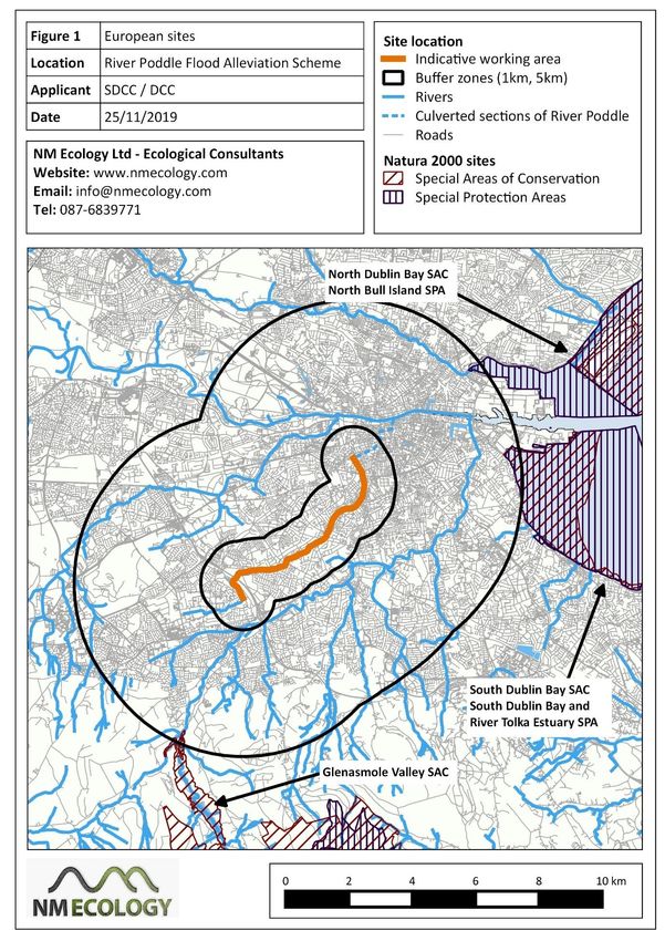
The River Poddle is a tributary of the River Liffey, which provides a potential hydrological
connection to a number of European sites in Dublin Bay (e.g. South Dublin Bay SAC, North
Dublin Bay SAC North Bull Island SPA, South Dublin Bay and River Tolka Estuary SPA). This
document provides supporting information to assist the competent authority with an
Appropriate Assessment, including: a description of the proposed development, an
outline of its environmental setting, details of European sites within the zone of impact,
an appraisal of potential pathways for indirect effects, and an assessment of whether
there will be adverse effects on the integrity of European sites.
Screening for Appropriate Assessment was carried out at an early stage in the design
process. As per case C-323/17 (CJEU), no mitigation measures could be taken into account
when undertaking this screening. It could not be excluded, on the basis of objective
information, that the proposed development, individually or in combination with other
plans or projects, would have a significant effect on a European site. Therefore, the
development proceeded to, and was considered, under Stage 2 of the Appropriate
Assessment process.
The hydrological pathway between the River Poddle and the European sites in Dublin Bay
rather tenuous, because any pollutants would be diluted by approx. 10 - 15 km of
intervening river and coastal waters. It is considered highly unlikely that any pollutants
generated by construction works (suspended sediments, concrete waters, hydrocarbons,
etc.) could reach Dublin Bay at high-enough concentrations to cause adverse effects on
the qualifying interests of the European sites. However, in accordance with the
precautionary principle, a range of pollution-prevention measures have been identified
which will be implemented during construction works.
The incorporation of these measures in full and their subsequent implementation on site
will remove any residual risk of significant effects on the River Poddle or downstream
European sites, beyond reasonable scientific doubt. It is therefore the considered opinion
of NM Ecology Ltd, as the author of this NIS, that, in making its AA in respect of theRevised Natura Impact Statement River Poddle Flood Alleviation Scheme
proposed development, An Bord Pleanála, as the Competent Authority in this case, should
determine that, given the full and proper implementation of the mitigation prescribed in
this NIS, the proposed development, either individually or in combination with other plans
or projects, will not adversely affect the integrity of the South Dublin Bay and River Tolka
Estuary SPA, South Dublin Bay SAC, North Bull Island SPA and North Dublin Bay SAC or any
other European site.Revised Natura Impact Statement River Poddle Flood Alleviation Scheme
Table of Contents
1 Introduction ....................................................................................................................... 2
1.1 Background to Appropriate Assessment ............................................................................ 2
1.2 Previous Appropriate Assessments of related developments ........................................... 3
1.3 Statement of authority ....................................................................................................... 3
1.4 Methods ............................................................................................................................. 4
2 Description of the Project ................................................................................................... 5
2.1 Environmental setting ........................................................................................................ 5
2.2 Description of the proposed development ........................................................................ 6
2.3 Operation of the Proposed Scheme ................................................................................. 19
2.4 Maintenance of the Scheme ............................................................................................ 19
2.5 Other nearby developments (potential in-combination effects) ..................................... 21
3 Description of European sites ........................................................................................... 22
3.1 European sites within the zone of influence .................................................................... 22
3.2 Identification of potential impact pathways .................................................................... 25
3.3 Further details of relevant SACs ....................................................................................... 26
3.4 Further details of relevant SPAs ....................................................................................... 27
3.5 Records of SPA bird species in the vicinity of the proposed development site ............... 29
4 Assessment of Potential Impacts....................................................................................... 32
4.1 Direct impacts................................................................................................................... 32
4.2 Indirect impacts ................................................................................................................ 32
4.3 Potential in-combination effects ...................................................................................... 36
5 Proposed Mitigation Strategy ........................................................................................... 36
5.1 Ecological Clerk of Works ................................................................................................. 37
5.2 Environmental management measures for hydrology / hydromorphology .................... 37
6 Residual Impacts .............................................................................................................. 42
7 Appropriate Assessment: Conclusion of Stage 2 ................................................................ 43
References .............................................................................................................................. 45
Appendix A – Surface Water Management Plan
Appendix B – Winter Habitat Study (ROD, 2018)Revised Natura Impact Statement River Poddle Flood Alleviation Scheme
1 Introduction
1.1 Background to Appropriate Assessment
Approximately 10% of the land area of Ireland is included in the European Network of Natura
2000 sites (hereafter referred to as European sites), which includes Special Protection Areas
(SPAs) to protect important areas for birds, and Special Areas of Conservation (SACs) to
protect habitats and non-avian fauna. Legislative protection for these sites is provided by
the European Council Birds Directive (79/409/EEC) and E.C. Habitats Directive (92/43/EEC, as
amended), which are transposed into Irish law by the European Communities (Birds and
Natural Habitats) Regulations 2011 (SI 477/2011).
In accordance with Article 42 of the national regulations, planning authorities must consider
the potential impacts of any development on the integrity of the Natura 2000 network. The
first stage of this process is a simple screening exercise to determine whether the
development has potential to affect any European sites. If there is any risk of impact
(adopting a precautionary approach), the development should proceed to the second stage
of the process, which is known as ‘Appropriate Assessment’ (AA). In Section 3.1 of
Appropriate Assessment of Plans and Projects in Ireland, Guidance for Planning Authorities
(2009), the second stage of the AA process is described as follows:
“This stage considers whether the plan or project, alone or in combination with other
projects or plans, will have adverse effects on the integrity of a Natura 2000 site, and
includes any mitigation measures necessary to avoid, reduce or offset negative effects.
The proponent of the plan or project will be required to submit a Natura Impact
Statement […] to identify and characterise any possible implications for the site in view
of the site’s conservation objectives, taking account of in-combination effects. This
should provide information to enable the competent authority to carry out the
appropriate assessment. If the assessment is negative, i.e. adverse effects on the
integrity of a site cannot be excluded, then the process must proceed to Stage 4, or the
plan or project should be abandoned. The AA is carried out by the competent authority,
and is supported by the NIS.”
Screening for AA was carried out at an early stage in the design process, and adopting a
precautionary approach, it was determined that Appropriate Assessment was required.
Therefore, this document is a (Revised) Natura Impact Statement (hereafter referred to as
NIS), which provides supporting information to assist the competent authority (in this case
An Bord Pleanála) with an AA, and includes the following sections: a description of the
proposed development, details of its environmental setting, details of European sites within
the zone of impact, an appraisal of potential pathways for indirect effects, and an
assessment of whether there will be adverse effects on the integrity of European sites.Revised Natura Impact Statement River Poddle Flood Alleviation Scheme
1.2 Previous Appropriate Assessments of related developments
A Natura Impact Statement was prepared by RPS Group Ireland in 2016 for the ‘Camac and
Poddle Prioritised Works’ project, which informed the design of the River Poddle Flood
Alleviation Scheme. The NIS for that project proceeded to Stage 2: Appropriate Assessment,
but following a review of potential impacts, it was concluded that there was no risk of likely
significant impacts. The following conclusion is provided at the end of the RPS report:
“The likely impacts to the integrity of the Natura 2000 network that could arise from
implementation of any of the options identified in relation to the Poddle and Camac
catchments have been examined. The implementation of the options will not have any
significant adverse effects upon the integrity of any Natura 2000 site. There are no
direct impacts on Natura 2000 sites associated with the options.
Any impacts associated with the options would be mainly limited to construction works
as well as one-off or intermittent maintenance activities, such as water quality impacts
e.g. sedimentation. The distance of the works from downstream Natura 2000 sites is
significant and likely to ensure that if there are emissions arising during the works
phase or maintenance activities, they will not reach the Natura 2000 sites and will not
impact on the sites’ qualifying interests. Any changes to hydrological and
morphological regimes will be limited to the catchment and will not affect Natura 2000
sites in downstream marine water bodies.”
1.3 Statement of authority
All surveying and reporting was carried out by Nick Marchant MCIEEM MSc, a qualified and
experienced consultant. He has twelve years of professional experience, including nine years
as an ecological consultant, one year as a local authority biodiversity officer, and two years
managing an NGO in Indonesia. He provides Appropriate Assessments and other ecological
services for developments throughout Ireland and Northern Ireland, particularly for
renewable energy developments, infrastructural projects (roads, water mains, etc), and
residential developments.
He holds an MSc in Ecosystem Conservation and Landscape Management from NUI Galway
and a BSc in Environmental Science from Queens University Belfast. He is a member of the
Chartered Institute of Ecology and Environmental Management and operates in accordance
with their code of professional conduct.Revised Natura Impact Statement River Poddle Flood Alleviation Scheme
1.4 Methods
These following guidelines were considered as part of this assessment:
• Appropriate Assessment of Plans and Projects in Ireland, Guidance for Planning
Authorities (Department of the Environment, Heritage and Local Government, 2009)
• Assessment of plans and projects significantly affecting Natura 2000 sites:
Methodological guidance on the provisions of Article 6(3) and (4), (European
Commission, 2002).
• Guidelines for Ecological Impact Assessment in the UK and Ireland (Chartered Institute
of Ecology and Environmental Management, Version 1.1 – Updated September 2019)
A desk-based study was carried out using data from the following sources:
• Plans and specifications for the proposed development
• Qualifying interests / conservation objectives of European sites from www.npws.ie
• Bedrock, soil, subsoil, surface water and ground water maps from the Geological
Survey of Ireland webmapping service (www.gsi.ie/mapping.htm), the National
Biodiversity Data Centre (http://maps.biodiversityireland.ie/), and the Environmental
Protection Agency web viewer (http://gis.epa.ie/Envision/)
• The South Dublin County Development Plan 2016 - 2022 and Dublin City Development
Plan 2016 - 2022, and details of permitted or proposed developments from the local
authorities’ online planning records
• A Winter Habitat Study of Tymon and Bancroft Parks (Roughan & O’Donovan
Consulting Engineers, 2018), which is provided in Appendix B of the NIS
• Appropriate Assessments of the Eastern CFRAM Study (RPS Group Ireland, 2016) and
of the Camac and Poddle Prioritised Works (RPS Group Ireland, 2014)
All desktop and field data was collected between September 2018 and September 2020. The
results of the 2018 field surveys are presented in full in EIAR, Volume 2, Part II, Chapter 7,
and the results of the August 2020 electrofishing and Q sampling surveys are appended to
Appendix 6 of the response to An Bord Pleanála’s Request for Further Information (RFI).
Extracts from these reports are not reproduced here in full, except where relevant to the
Appropriate Assessment process.Revised Natura Impact Statement River Poddle Flood Alleviation Scheme
2 Description of the Project
2.1 Environmental setting
The River Poddle is a highly-modified urban watercourse that arises in Cookstown / Tallaght
and flows in a north-easterly direction through Dublin city to meet the River Liffey at
Wellington Quay. The proposed working area covers a section of the watercourse between
Tymon North in Tallaght and Saint Teresa’s Gardens in Merchant’s Quay, Dublin.
The underlying bedrock is dark limestone and shale of the Calp formation, which is a locally-
important aquifer (moderately productive in local zones). Subsoils are limestone till and
localised pockets of limestone gravels, while soils are gravels and alluvium along the original
course, with made ground and brown earths along re-aligned sections.
Description of the River Poddle
The river was part of the original settlement of Dublin city in the 9th century, forming the
Dubh Linn (dark lake) after which it is named. However, as the city expanded the river was
extensively modified, including culverting under roads and residential areas, and
realignment along property boundaries. The most significant change was the enclosure of
the lower section of the river under Dublin city centre, comprising approx. 2 – 2.5 km of
culvert between Harold’s Cross and Wellington Quay. Five other sections of the river have
been culverted under residential developments, each of between 100 and 500 m length. The
most extensive re-alignments are at the source of the river in Tallaght, where it has been
aligned along boundaries in an industrial estate, and in Tymon Park, where it has been
widened to form a series of ponds and lakes.
The extensive modification of the river has significantly reduced its ecological value. It is
understood that the river has no populations of salmonids or any other fisheries interests
(pers. comm. Inland Fisheries Ireland Environmental Officer), and that the culvert in the
lower section of the river is impassable to migratory species (e.g. Atlantic salmon or sea
trout).
Water Quality
The River Poddle is not monitored under the Water Framework Directive Status Assessments
2013 - 2018. However, considering the extensive hydro-morphological changes to the river,
it is likely that it would have a classification of ‘poor’ or ‘bad’ status under the WFD
monitoring scheme.
Some water quality data obtained from South Dublin County Council is presented in the
Planning Report for the Integrated Constructed Wetland (Vesi Environmental Ltd, 2019) that
is contained in Volume 4 of the EIAR. The levels of both nitrates and phosphorous exceeded
the limits for “Good” water status as defined in the Surface Water Regulation (S.I. 272/2009,Revised Natura Impact Statement River Poddle Flood Alleviation Scheme
as amended). Water quality monitoring was undertaken at four locations along the River
Poddle (Tymon North, Tymon Park, Whitehall and Ravensdale Park) in 2020, and a Q-value
of 3 was recorded at all locations, which is defined as ‘moderately polluted’. In summary,
water quality in the River Poddle is currently considered to be relatively poor, due to
elevated levels of nutrients, and to extensive modification of the watercourse.
Further downstream, the transitional / estuarine waters of the River Liffey are of moderate
status, and coastal waters in Dublin Bay are of good status (Water Framework Directive
Status Assessments 2010-2015).
2.2 Description of the proposed development
The proposed works extend from the upper reaches of the River Poddle at Tymon North in
Tallaght to Saint Teresa’s Gardens in Merchant’s Quay, Dublin. An outline of the proposed
works is provided below:
• Raised earthen flood embankments along the upper reach of the River in Tymon
North (west of the M50) and Tymon Park (east of the M50) to provide flood
protection. The embankment at Tymon Lake in Tymon Park will be constructed to
provide the main flood storage in the Scheme and a flow control structure at Tymon
Lake will control flows downstream in a flood event.
• An integrated constructed wetland in Tymon Park to improve water quality.
• New, replacement or reinforced flood walls to provide flood protection in residential
areas in the middle reach of the River at Whitehall, Kimmage and Perrystown; at
Wainsfort Manor Crescent, Terenure; to the rear of properties on Fortfield Road south
of Kimmage Crossroads, Kimmage; at the end of St. Martin’s Drive in Kimmage; and at
Mount Argus Close in Harold’s Cross.
• Channel realignment and regrading in Whitehall Park to provide clearance between
the River and adjacent properties for flood protection.
• Providing sealed manholes in the vicinity of Poddle Park and Ravensdale Park,
Kimmage, and in St. Teresa’s Gardens and Donore Avenue, and at the National
Stadium in Merchant’s Quay, Dublin.
• Ancillary works and associated development including drainage channel clearance
and removal of trees where required for the works; rehabilitating or installing culvert
screens in locations as required; installing flap valves in all culverts draining to the
River; biodiversity enhancements including installation of floating nesting platforms
in Tymon Lake, Tymon Park, Tallaght; and landscape mitigation and restoration at
Tymon Park, Tallaght, Whitehall Park, Terenure, and Ravensdale Park and St. Martin’s
Drive, Kimmage including public realm improvements, replacement footbridges,
biodiversity enhancements, tree planting and landscaping.Revised Natura Impact Statement River Poddle Flood Alleviation Scheme
• Temporary works include a main construction compound in Tymon Park with access
off Limekiln Road, which will be in operation for the entire duration of the works.
Additional temporary works/ set down areas at Wainsfort Manor Crescent, St.
Martin’s Drive and Ravensdale Park, which will be in use for the duration of the works
to be carried out in these locations. Other temporary works include temporary
stockpiling of excavated earth in Tymon Park; temporary channel crossings at Tymon
Park (west and east of the M50) in Tallaght, and channel diversions at Tymon Park,
Tallaght and Whitehall Park, Templeogue to enable the works along the River channel
to be carried out.
A detailed description of the proposed works is contained in EIAR, Volume 2, Part I, Chapter
5 and illustrated in EIAR, Volume 3. Key sections of the Chapter 5 are reproduced below
(unedited), but in the interests of brevity it is not considered necessary to reproduce all
sections.
It is noted that Section 5.12 Best Practice Construction Measures has not been reproduced
here, in order to avoid any ambiguity regarding the inclusion of mitigation measures at the
screening stage of a development. Best-practice construction measures will only be
considered in Section 5: Proposed Mitigation Strategy of this Natura Impact Statement.
2.2.1 Construction of the Proposed Scheme
A brief description of how the main elements of the works will be constructed is provided
below. Further detail can be found in the Outline CEMP contained in EIAR Volume 4,
Appendix 5.1 and planning drawings submitted as Part 2 of the planning application
documentation.
Site Access
For the most part, works areas will be accessed from public property or public roads. Access
to private property may be required in locations where walls have to be replaced. The
preference is to undertake these works from the bank opposite where there is sufficient
space and where workers can operate machinery safely.
Temporary Works Compounds
The primary construction compound will be located within Tymon Park with an entrance off
Limekiln Road (Drawing No. 08140 of the planning drawings) which will be in place for the
entire duration of the works (24 months). The entrance to the works compound off Limekiln
Road will be created by removing a section of the block wall and fence. Some trees will be
required to be removed for the compound. The main works compound will have a surface
created by stripping topsoil and subsoil, laying down geotextile material and then laying a
working surface of crushed stone. The excavated soils will be stored at the site forRevised Natura Impact Statement River Poddle Flood Alleviation Scheme
subsequent use in reinstatement. The compound will have site offices, welfare facilities and
car parking. It will be fenced with a 2.4m high chainlink fence and hoarding.
Only materials and plant necessary for the works will be stored there. Oils, lubricants,
solvents, fuel, etc may be stored in bunded areas on site.
Works / set down areas will be established at Wainsfort Manor Crescent, Ravensdale Park
and St. Martin’s Drive as above. These will be fenced, temporary compounds without offices
to securely store machinery and some materials.
Temporary Access Tracks
Temporary access tracks through Tymon North and Tymon Park have been carefully
designed to avoid sensitive habitats and ecological features. In some cases, these routes
make use of existing pedestrian and vehicular accesses which will be widened and
constructed as necessary making a firm base as with the works compounds.
Before construction commences any works areas that overlap with public roads and
pedestrian footpaths will be isolated with security fencing and construction hoarding. Every
effort will be made to ensure the public can continue to enjoy public areas, considering
health and safety of the workers and public.
Temporary River Crossings
The works to create the embankments in Tymon North and Tymon Park will require river
crossings at strategic locations of a width of 4m to 6m. The riverbank will be partially graded
back to an angle of approximately 45 degrees over a 6m length of both banks. A layer of
geotextile membrane will be placed along the regraded bank profile, and a 6 to 8m length of
precast concrete pipe (750 to 900mm diameter) will then be placed in the channel and
backfilled using crushed virgin rock up to a level of just below top of bank. When works are
complete the backfill and pipe will be removed from river and the banks will be
reconstructed by compacting.
Material Stockpiling
The top layer of soil (approximately 200mm depth) contains valuable ecological material that
will be saved separately from subsoils and will be used to reinstate excavated areas and
allow for natural restoration and establishment of plants. Stockpiles of this material are to
be stored in banks no more than 1m high.
All materials excavated from the works areas will be stockpiled as close to the area where
they are to be re used in landscape restoration in order to minimise on-site haulage and
double handling. Areas for material storage in Tymon Park have been chosen with
consideration of sensitive habitats and ecological features and use of the green spaces in the
Scheme. These are shown on Drawing No. 08148 of the planning drawings.Revised Natura Impact Statement River Poddle Flood Alleviation Scheme
Stockpiles of other material will be formed no more than 2m in height and will be sealed
using the back of an excavator bucket or tracked upon by a tracked excavator to ensure the
stockpile does not become saturated and therefore difficult to handle when being reinstated
into the works. All stockpiles will be clearly defined, fenced and signed to ensure no cross
contamination of other materials to be stockpiled. It is estimated that approximately
3,000m3 will be temporarily stockpiled at Tymon Park for re-use.
An estimated 5,000m3 of material is to be excavated and reused elsewhere on site or locally.
The excess material from the excavation works will be used as bulk fill, embankments or
landscaping where possible. It is estimated that 50% of the material will be required for the
embankments and landscaping and the remainder will be taken off site for disposal at an
agreed licensed area. All material removed from site will be disposed of in accordance with
relevant waste management legislation. Where material cannot be reused on site, it will be
exported to co-ordinate deliveries of imported fill with a load of unsuitable material
requiring removal from site in order to minimise traffic movements.
Tree Removal
Individual trees and tree groups which are impacted by the proposed development have
been identified through a specially commissioned tree survey. The findings of the tree survey
are illustrated in the tree classification, tree constraints and tree removal and protection
areas drawings, along with records of the number and species of trees affected by the
Scheme in the surveyed areas. The findings of the tree survey are reported in the Tree Survey
and Arboriculture Impact Assessment Report contained in EIAR Volume 4, Appendix 5.2.
The drawings to accompany the tree survey are contained in EIAR Volume 3. This Report has
updated following a RFI from An Bord Pleanála on the planning application for the River
Poddle Flood Alleviation Scheme and is included in Appendix 4 of the response to the RFI.
Trees will be removed in advance of the works in accordance with the approved Construction
and Environmental Management Plan. Any trees that have to be removed during nesting
periods will be done under the supervision of the Ecological Clerk of Works.
The proposed development of the Flood Alleviation Scheme will require the removal of a
number of trees to facilitate both the Scheme itself and the construction process. The
majority of trees lost are of moderate value. New semi mature tree planting is proposed as
an integral part of the Scheme, which will assist in mitigating the proposed tree removals.
The report concludes with recommendations for protection measures to ensure the
conservation of those tress to be retained during the construction process.
Earthen Embankments
The proposed works to construct the embankments will require removal of trees in Tymon
North and Tymon Park for access by machinery and personnel.Revised Natura Impact Statement River Poddle Flood Alleviation Scheme
Topsoil will be stripped from the footprint of the embankment before the construction
starts. This will help to key the embankment to its foundation and to reduce settlement. The
material will be stored for reuse in landscape restoration in accordance with the landscape
mitigation plan in EIAR Volume 3.
Approximately 3,000m3 of preferably clayey material will be required to be brought on to
site to construct the embankment at Tymon Lake. Wherever possible uncontaminated,
locally sourced material will be used. The required strength will be achieved by constructing
the embankment in layers and compacting each layer using the appropriate mechanical
plant.
If the construction material is highly permeable, prevention measures must be in place to
avoid seepage through the foundation. Sheet piles can be driven deep enough into the core
of the embankment to provide an effective cut off.
After construction of the embankments the works areas will be reinstated. Any remaining
material after the construction is complete will be removed from the site and disposed of in
accordance with relevant waste management legislation.
Activities such as final landscaping and grass seeding will take place after the construction is
complete in accordance with an agreed landscaping plan.
Flow Control Structure
Construction of the flow control structure at the embankment at Tymon Lake will follow
after the piles are installed. Sheet piles will be used to hold the stream flow. An excavator
will be used to dig a trench and install a pre-cast 900mm concrete pipe which will be
backfilled to provide a temporary bypass of the River while the flow control structure is being
constructed. The sheet pile will then be removed to allow the flow to pass through the
temporary culvert. A sheet pile cofferdam will be constructed around the footprint of the
flow control structure. This will be below the level of the embankment to permit the Poddle
River to flow during possible extreme events. Whilst the flow control structure is being
formed, a pump will remove water with silt controls including a silt bag and a settlement
tank. The structure will be formed of concrete and poured in sections. Pumping operations
will be discontinued when concrete is being placed adjacent to groundwater. After the
structure is completed, the sheet piles and the temporary bypass pipe will be removed by
an excavator. The embankments will be constructed around the flow control structure in the
method described above.
Integrated Constructed Wetland
The main earthworks activities involved in the development of the Integrated Constructed
Wetland (ICW) in Tymon Park are levelling, excavation, and placement of soils for integration
with existing topography. An estimated 5,000m3 of material is to be excavated and reusedRevised Natura Impact Statement River Poddle Flood Alleviation Scheme
elsewhere on site or locally. The excess material from the excavation works will be used as
bulk fill, embankments or landscaping where possible. It is estimated that 50% of the
material will be required for the embankments and landscaping and the remainder will be
taken off site for disposal at an agreed licensed area. All material removed from site will be
disposed of in accordance with relevant waste management legislation. The main
construction works are briefly summarised below, and more detail can be found in EIAR
Volume 4, Appendix 5.3 with accompanying maps displayed in EIAR Volume 3.
A temporary river water management system will need to be established during the
earthworks. To reduce the impact of construction works on the river flow the ICW will first
be constructed outside of the river channel and erecting temporary bunds along the existing
river route to contain and maintain river flows.
The stone baffles and stone weir and are to be installed at the inlet point and outlet points
respectively from material acquired from site where suitable and available, otherwise locally
sourced natural stone can be used.
On completion of construction and planting, the river will be diverted into the ICW and
temporary bunds removed. The ICW can then be finished off with remaining levelling and
planting where required. Careful timing with regards to weather conditions and silt
mitigation methods will need consideration prior to construction stage scheduling. All
instream works should ideally be carried out in low flow periods (i.e. between July to
September), unless otherwise agreed.
There should be no requirement to import or export material to or from the site for
construction of the ICW, however this will need to be confirmed during site investigation.
Indicative levels are provided in the ICW layout Drawing No. 08146 of the planning drawings.
The base of the ICW cell will be completely level to promote dispersal across the entire
treatment area. The slope gradient will vary depending on landscaping requirements but will
be at 4:1 minimum. There may be slight variations to the layout and level of the ICW during
construction, as required, so as to work within the confines of the site conditions and to
utilise the characteristics of the site.
Appropriate access will be provided around the ICW site to allow for future monitoring and
maintenance works. Access to the site will be via existing park paths.
Channel Re-Alignment
At Whitehall Park the channel will be re-aligned to take it away from the adjacent properties,
and a meander introduced along with other measures to encourage channel naturalisation.
The channel re-alignment will be achieved with the temporary diversion of flows through
the use of sheet piles in the same method as the flow control structure in Tymon Lake.Revised Natura Impact Statement River Poddle Flood Alleviation Scheme
Flood Defence Walls
Flood defence walls are proposed for areas to prevent the River overflowing its banks in the
middle reaches. This will involve reinforcing existing walls, constructing new walls in places
where there currently are none, and replacing existing walls. The flood defence walls will be
constructed by the methods briefly described below. Selection of this method will depend
on the condition of the existing foundation and wall, ground conditions, the height of the
wall, and proximity of structures to the wall.
The construction of walls, whether reinforced or new walls, will require vegetation clearance
on both banks.
Prior to construction the route of the proposed flood protection walls will be surveyed and
set out. Any works areas that overlap with public roads and pedestrian areas will be isolated.
The construction of the walls will require some movement of materials to and from the site.
Most of the materials leaving the site will consist of spoil from the excavation works and
some demolition rubble. The excess material from excavation works that is not used as bulk
fill, embankments or in landscaping will be removed from the site and disposed of in
accordance with relevant waste management legislation.
Once the walls are constructed the area will be backfilled and reinstated. The walls will be
finished in stone cladding or pointed with concrete capping beam on top. Reinstatement of
lands and finishes will be to a specification agreed with the construction management team,
SDCC and OPW.
Reinforcing walls
In cases where an existing wall is not structurally sound to withstand a flood it may be
necessary to construct a scour protection beam. The advantage of this method is that it will
avoid working in the rear gardens of properties, and the walls can be accessed from the
opposite bank using an excavator. Culverts approximately 600mm will be installed in the
channel to allow works to be undertaken by personnel. Channel flows will be temporarily
diverted using 600mm pipes and a pump sump will be installed to direct the flow through a
baffled settlement tank and discharged through a silt bag. A trench will be excavated
alongside the existing wall foundation. The wall will be shuttered, then a reinforcing cage
will be placed in the trench. The cage will then be filled with concrete and following this the
pump would be switched off. Depending on the mix and ambient conditions the shutter
would be struck in 24 to 48hrs and the process repeated. Once at the end of a 20m run, the
haul road stone, pumping system, etc. would be moved along and the same process
repeated until the scour beam is complete.
In certain situations, it may be necessary to retain the existing boundary wall and construct
a new wall adjacent to or up against it. A possible solution will be to underpin the existingRevised Natura Impact Statement River Poddle Flood Alleviation Scheme
foundation and construct a new wall up against the underpin and extend this up to the
required design level. The underpinning process is similar to that described for the scour
protection beam with the exception that each underpin will only be in the order of 1m at a
time when measuring along channel chainage so as to minimise the amount of unsupported
foundation. Therefore, this process is considerably slower than that of the scour beam
works.
New or replacement walls
Walls will have a precast base and will be constructed in situ. The walls will have to be
underpinned as above, and a stone platform will be constructed, and the flow diverted
through silt controls as above. It may be beneficial to precast (at a precasting yard) the bases
of these units in lengths of 2m keeping the weight down avoid the use of very large
excavators/cranes. Precasting would also minimise the need for pumping during the
construction of the bases. It would be necessary to dig out and bed the bases at the required
level and place them in units of 10m at a time. The bases will then be shuttered and poured.
These works will be undertaken from the opposite (right) side of the bank using an excavator
for digging and lifting operations.
Footbridge Replacements
The replacement of the footbridge in Ravensdale Park will involve the demolition of the
existing bridge, excavation of foundations for the proposed bridge, craning in a precast
concrete bridge and reinstatement of the area impacted by the works. The existing
footbridge at Tymon Lake will be replaced with a new structure along the embankment using
a similar method.
It is expected that any utility diversions required for the replacement of the bridge at
Ravensdale will be completed prior to the demolition of the existing bridge.
Manhole Works
The work on manholes will be either to rehabilitate or replace manholes to seal them. The
manhole at the rear car park of the National Stadium is required to be rehabilitated to
improve access for maintenance. The manhole rehabilitation works will consist if reinforcing
the manhole chamber with concrete and anchoring the chamber to the concrete with an “L”
bar, then replacing the cover and frame with a sealed unit or by replacing the covers with a
sealed frame/cover solution.
With the exception of the manhole at the rear car park at the National Stadium, the
manholes works will take place within the public roads. Works areas will be fenced off and a
traffic management system will be put in place whilst manhole works are ongoing.Revised Natura Impact Statement River Poddle Flood Alleviation Scheme
2.2.2 Duration and Sequencing of Construction
It is envisaged that, subject to approval by the Board, construction will commence before
March 2021 and will take 24 months to complete. There will be six main works areas, namely
Tymon North and Tymon Park; Whitehall Park and Wainsfort Manor Crescent; Fortfield
Road; Ravensdale Park and Poddle Park; St. Martin’s Drive and Mount Argus, and St. Teresa’s
Gardens / Donore Avenue / National Stadium. The expected construction duration for each
area is given in Table 1.
After establishing the main works compound in Tymon Park, access tracks and setting out
works areas, works will begin in Tymon North and generally move downstream, however the
sequencing and duration of works will be dependent on weather and ground conditions.
There is a priority to carry out work on the embankment at Tymon Lake and in-stream or
adjacent to stream works during low flow periods of May to September.
Table 1: Estimated construction programme
Location Main Flood Alleviation Scheme works Estimated
maximum
construction
period
(cumulative
months)
Tymon North and Establish & maintain main contractor’s compound 24 months
Tymon Park for Scheme duration
Tree removal, excavations, demolition of flow
control structure, stockpiling earth material,
removal and import of earth material, formation of
embankments, removal and replacement of flow 6 months
control structure incorporating footbridge, ICW,
site restoration, landscape mitigation/replacement
tree planting, and biodiversity enhancements
Whitehall Park / Establish temporary works/set down area, 5 months
Wainsfort Manor excavations, removal and import of earth material,
Crescent channel re-alignment and re-grading,
construction/installation of flood protection walls,
channel naturalisation, site restoration,
biodiversity enhancements and replacement tree
planting
Fortfield Road & Establish temporary works / set down area, tree 7 months
Ravensdale Park removal, demolition and replacement of
footbridge, construction/installation of flood
protection walls, site restoration, landscape
mitigation/public realm improvements and
replacement tree planting.Revised Natura Impact Statement River Poddle Flood Alleviation Scheme
St. Martin’s Drive and Establish temporary works / set down area, tree 4 months
Mount Argus removal, construction/installation of flood
protection walls, channel naturalisation,
replacement tree planting and landscaping
Poddle Park / St Establishing temporary works area, traffic 2 months
Teresa’s Gardens / management, road works to rehabilitate or replace
Donore Avenue / existing manholes
National Stadium
2.2.3 Construction Management
The Contractor will be obliged to prepare a Project Controls Procedures Manual (PCPM) prior
to commencement of the works. The purpose of the PCPM is to define the contract specific
strategy for the management and control of the Project and to describe the procedures and
policies for its successful completion.
The Contractor will also be obliged to prepare a Construction Environmental Management
Plan (CEMP) which will set out proposed measures to mitigate against environmental
impacts during the construction and operational stages including the mitigation measures
set out in the EIAR.
An outline CEMP has been prepared by Nicholas O’ Dwyer Ltd. and is contained in EIAR
Volume 4, Appendix 5.1. A Surface Water Management Plan (SWMP) has been provided in
response to the RFI. This plan is appended to this NIS.
The outline CEMP and SWMP will be referred to by the appointed Contractor. The Contractor
will take account of all recommendations contained within the outline CEMP and SWMP,
and expand, as appropriate.
Throughout the progress of the works, the Contractor shall also take account of relevant
legislation and best practice UK CIRIA guidance including but not limited to the following:
• C532 Control of water pollution from construction sites: guidance for consultants and
contractors;
• SP156 Control of water pollution from construction sites – guide to good practice.
The Contractor’s construction method statements shall also indicate how management,
monitoring, interception, removal and/or treatment of silt run-off shall prevent
contamination of ground or surface waters by mobilisation of soil particles. Fail-safe site
drainage shall be provided to prevent discharge of chemical spillage from the construction
site. All road and hardstanding areas with potential for contamination shall be drained to a
suitable receptor where they can be stored for removal and disposal off-site. The Contactor
will be obliged to comply with the mitigation measures which are compiled and set out in
Chapter 17 Summary of Mitigation Measures & Residual Impacts.Revised Natura Impact Statement River Poddle Flood Alleviation Scheme
In respect of noise control during the construction works, the Contactor will be obliged to
comply with the mitigation measures set out in Chapter 12 Noise and Vibration of the EIAR.
In respect of dust and air pollution, the Contractor shall be obliged to comply with the
mitigation measures set out in Chapter 13 Air Quality and Climate of the EIAR.
Mitigation measures identified within each subject area and agreed with the planning
authority will be written into the Contract Documents.
In respect of the above, it is noted that the construction will be monitored by a resident
engineer and Ecological Clerk of Works (ECoW) to ensure compliance with the Contract
Documents and the environmental mitigation measures set out herein.
It is noted that the CEMP, SWMP and other construction-phase measures outlined in Section
2.2 of the NIS would be considered ‘mitigation measures’ in the context of Appropriate
Assessment, as per CJEU case C-323/17. For the avoidance of doubt, these measures are
presented here to provide a comprehensive description of the proposed development, but
they do not yet form part of the Appropriate Assessment process. The implementation of
these measures is only considered as part of the proposed mitigation strategy outlined in
Section 5 of the NIS.
2.2.4 Construction Materials
An estimated schedule of principal materials and quantities is presented in Table 2. In so far
as possible, construction materials will be from local sources. All imported material that will
be used on site will be procured from approved sources and biosecurity measures will be
adhered to.
Table 2: Schedule of Principal Materials and Quantities
Description Tonnes
Concrete 2,700m3
Reinforcement 300T
Earth material 8,200m3
All construction products will be required to be subject to the European Union (Construction
Products) Regulations 2013 and carry the CE marking. The Construction Products Regulations
aim to ensure that reliable performance-related data is made available, by means of
Declarations of Performance, in relation to construction products being placed on the
European market.
It is envisaged that deliveries of materials will occur on a ‘just in time’ basis to reduce the
requirement for storage on site. Temporary hard standing areas with drainage to aRevised Natura Impact Statement River Poddle Flood Alleviation Scheme
hydrocarbon interceptor will be constructed before refuelling/servicing activities will be
allowed onsite. These areas will be bunded. Temporary bunded and suitably equipped areas
will also be in place before any potentially polluting materials (oils, lubricants, solvents, fuel,
etc.) can be stored on-site. Temporary stockpiling and storage of construction materials will
only be allowed in designated areas.
2.2.5 Waste Management
The wastes expected to arise as a result of construction would be mostly earth from
excavations. The project will aim to reuse as much excavated material in the Flood
Alleviation project. Any earth material that is removed from the sites will be done in strict
accordance with the relevant waste management legislation. For all works, any waste
generated during the construction phase will be adequately segregated and stored prior to
transfer to an authorised facility for recovery/recycling/disposal.
During the construction phase both solid and liquid waste will be produced at the site. All
domestic effluent generated on site will discharge to temporary sewage containment
facilities prior to transport and treatment off-site by an authorised contractor. Waste oils
and solvents will be stored in a temporary bunded area prior to transport off-site by a
licensed contractor.
2.2.6 Risk of Major Accidents and/or Disasters
In carrying out this EIA, the project team have considered scenarios of accidents and / or
disasters that could occur during the construction and operational phases of the project.
Every effort has been taken in the design of the Flood Alleviation Scheme, and best practice
mitigation measures will be instituted by the Contractor, to ensure protection of the
environment during construction and operation of the Scheme in order to reduce or prevent
the risk of major accidents and/or disasters.
Failure of the Flood Storage Embankment at Tymon Lake
Although the flood storage embankment is designed following rigorous reservoir analysis
and testing, according to best international practices and standards under the supervision
of a UK All Reservoirs Panel Engineer, the scenario of a failure of the flood storage
embankment at Tymon Lake has been assessed qualitatively for its potential impacts. In the
event of a structural failure, the volume stored behind the embankment would be released
and flood the neighbourhoods immediately downstream of Tymon Park. The flow control
structure is likely to still be functioning in that event, but a sudden release of water would
result in severe flooding of the residential properties in the path of the released flood waters.
The additional flood storage at Whitehall Park and Ravensdale Park would provide a degreeRevised Natura Impact Statement River Poddle Flood Alleviation Scheme
of attenuation and help in alleviating the effects of a sudden surge of water further
downstream in such an extreme and unlikely event.
Overtopping the Flood Defence Structures
The proposed Flood Alleviation Scheme is designed for a 1% AEP event. The flood storage
embankment will act as a spillway in events exceeding the 1% AEP event, controlling the
release of excess water above the 1% AEP volume from the storage area and ensuring the
embankment does not fail up to and including the Probable Maximum Flood event. Any
water released over the spillway in events exceeding the 1% AEP event would cause localised
flooding in Tymon Park extending towards the Osprey and Willington estates. However, this
flooding would be much less than that which would occur in the absence of the storage area,
and it is only the exceedance volume above the 1% AEP volume which would be released.
Release of excess volume over the spillway in events of greater magnitude than the design
1% AEP event is not a failure of the Scheme.
Failure of the Flood Walls
Another scenario is that the flood protection walls that are constructed or replaced in the
Scheme fail by collapse or undermining, thereby causing flooding in adjacent properties.
Existing walls along the River have been structurally assessed for their flood protection
capability, and the walls to be replaced have been identified in this Scheme. To overcome
this potential, a robust programme of maintenance will be instituted to check the walls
periodically and carry out any remedial works.
Risk of large-scale pollution events
The construction of the proposed development will involve working with a range of
pollutants, including suspended sediments, concrete / cement products, and hydrocarbons
(oil, petrol, diesel, etc). Under normal working conditions these products would be kept
within the working area and would not reach any waterbodies. However, there is a risk of
accidental pollution events, for example:
• The collapse of a section of river bank or sediment stockpile could release sediment
into the watercourse
• When pouring concrete for a flood defence wall, shuttering could fail, releasing liquid
concrete into the watercourse
• A major fuel spill during the re-fuelling of a construction vehicle could release
hydrocarbons into the watercourse
The scale of such events could vary substantially, ranging from a small quantity of material
that could have a localised effect on the watercourse, to a large quantity of material that
could have a significant effect on the watercourse and downstream waters. It is important
to note that pollution events are unlikely, and that large-scale events would be highlyRevised Natura Impact Statement River Poddle Flood Alleviation Scheme
unlikely. However, for the purposes of Appropriate Assessment it is necessary to consider a
worst-case scenario, in accordance with the precautionary principle.
2.3 Operation of the Proposed Scheme
In flood conditions, the flow control structure in Tymon Park will restrict flow from Tymon
Park lakes to a maximum of 748 l/s which is the equivalent of the 2-year return period flow.
In storm events of greater magnitude than a 2-year return period the excess volume of
floodwater will fill the storage area in Tymon Park lakes and be contained by the flood
storage embankment. A storage volume of 66,000m3 will be provided, which is sufficient to
accommodate the attenuated volume in excess of the 100-year return period event.
Downstream of Tymon Park, the River will be contained in channel by the proposed flood
walls. In Ravensdale Park, once the capacity of the culvert at the downstream end of the
Park has been exceeded, excess volume in the region of 800m3 will be stored within the Park
and will begin re-entering the culvert once the flood levels recede.
The Scheme also includes an ICW, which purpose is to improve water quality in the River.
The ICW is a biological system designed to take the water from the River at a flow rate of
15l/s through the baffles, then through dense vegetation where it is exposed to biological,
chemical, and physical processes that reduce the concentrations of pollutants. These
pollutants remain within the wetland area where many are broken down to become a source
of nutrients to the resident biological communities. Other dissolved contaminants such as
heavy metals which are not utilised become embedded in the underlying sediment by
adsorption processes and thus do not enter river water. Water leaving the ICW at the
downstream end will be of a higher quality characterised by a lower pollutant profile and
increased oxygen levels.
An important element of the operation of the Scheme is its ongoing maintenance. The
section following describes the existing maintenance regimen in operation by each Council,
and the proposed measures which will be instituted as part of the Flood Alleviation Scheme.
2.4 Maintenance of the Scheme
Existing measures
Following the flood of October 2011 level alarms and CCTV were installed at the Lakelands
overflow weir, Wainsfort Manor culvert, and Gandon Close. These alarms notify SDCC/DCC
Drainage Departments when water levels rise to a certain point which might indicate a
blockage or obstruction at the culvert inlet screen. It was noted in the post flood review after
the 2011 event that better co-ordination was required between SDCC and DCC Drainage
Departments in providing quick organised responses to flood events.Revised Natura Impact Statement River Poddle Flood Alleviation Scheme
In addition to responding to potential flood events, the issue of channel maintenance and
cleaning is a critical factor in reducing flood risk. Tree and garden cuttings, fly-tipping and
general dumping of discarded furniture and white goods into the river channel is
unfortunately a common occurrence in the River Poddle and is well highlighted from
discussions with local residents and also from some local community groups such as the
Crumlin Cleanup Committee. In addition to the flood risk, this poses both ecological risk to
the riverine habitats from pollution but also a health and safety risk for those tasked with
their removal.
The current maintenance programme for both local authorities is described below.
SDCC
• Once a year at the end of August the river channel it is completely unchoked by hand.
Crews walk the stretch from Tymon Lakes to the screen at Kimmage Manor. Water
level monitors which are linked to automatic alarms to SDCC personnel in addition to
cameras (CCTV) was also installed at this location and at Lakelands overflow weir.
• The inspectors check the screens along this section once a week, if there is material
on them it is removed.
• There was a pre-screen added in 2015 at the green space adjacent to Templeville
Road.
DCC
• All existing screens are cleaned on Monday and Friday every week or before
forecasted heavy rain.
• Any other observed large debris such as cars, trees or tree branches, etc is removed
from the river. Any reports of large debris in the river or fly tipping are investigated.
• The screen in Gandon Close was modified after the flood of 2011 and a second debris
screen was installed upstream. The upstream screen has water level monitors
upstream and downstream which are linked to automatic alarms to DCC personnel. A
camera (CCTV) was also installed at this location
Proposed Measures
When the Flood Alleviation Scheme is complete a robust programme of maintenance will be
instituted by each Council to ensure that culvert screens and channels are kept clear of
debris and the Flood Alleviation Scheme functions properly during a storm event. The
maintenance works include carrying out repair works on existing walls and clearing
vegetation and debris that has accumulated in the channel. A register of the flood defence
assets in SDCC and DCC areas will be compiled as part of the Scheme to ensure that no
subsequent developments remove or alter the flood defence asset without SDCC/DCC
review. Flood defences will be incorporated into the development plans for both authoritiesYou can also read