Floodplain Management Plan Repetitive Loss Area Analysis Downe Township, New Jersey - Prepared by Rutala Associates July 2021 Nantuxent Creek ...
←
→
Page content transcription
If your browser does not render page correctly, please read the page content below
Floodplain Management Plan
                       Repetitive Loss Area Analysis

                       Downe Township, New Jersey

Nantuxent Creek – 1904, Money Island Marina

                      Prepared by Rutala Associates
                                     July 2021

                                                       1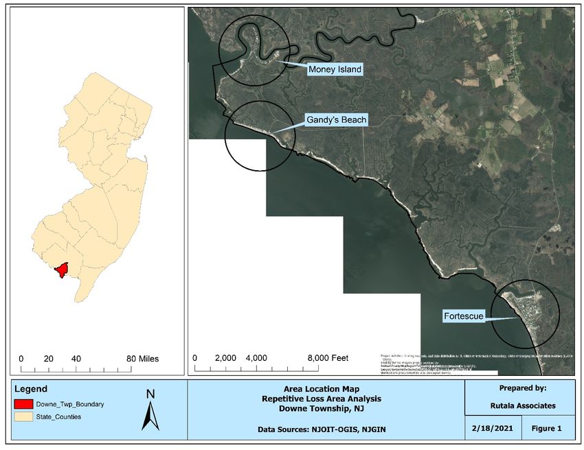
TABLE OF CONTENTS
1     Introduction ......................................................................................................................................... 3
2     Background .......................................................................................................................................... 4
3     Study Methodology, Results, and Analysis ........................................................................................ 6
4     Community Rating System (CRS) ....................................................................................................... 8
5     Repetitive Loss Area Analysis ............................................................................................................ 9
    5.1      Step 1: Project Notification ....................................................................................................... 11
    5.2      Step 2: Planning Coordination and Review ............................................................................. 11
      5.2.1          Resiliency Planning Documents ....................................................................................... 13
      5.2.2          Ongoing Resiliency Projects ............................................................................................. 19
      5.2.3          Proposed Projects.............................................................................................................. 28
    5.3      Step 3: Field Visits & Data Compilation ................................................................................... 29
    5.4      Step 4: Alternatives Analysis .................................................................................................... 31
    5.5      Step 5: Recommendations ........................................................................................................ 35
6     References .......................................................................................................................................... 41

This Floodplain Management Plan was partially funded by a Federal Emergency
Management Agency through a Flood Mitigation Assistance Grant. The purpose of the grant
was to reduce the overall risk to the population and structures from future hazard events,
while also reducing reliance on Federal funding for future disasters. The approved scope of
work consists of participation of agencies, stakeholders, and the public; hazard identification
and risk/vulnerability assessment; mitigation strategies; plan adoption; and plan
maintenance.

                                                                                                                                                            2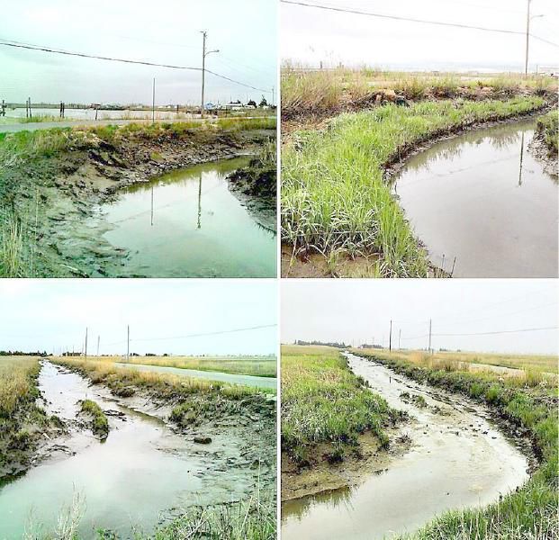
1 INTRODUCTION
Downe Township is located in the southern portion of Cumberland County, New Jersey
bordering the Delaware Bay. Downe Township, particularly Gandy’s Beach, Money Island,
and Fortescue are historic fishing villages providing the area with a rich cultural history and
valuable ecological resources. Due to their landscape position and proximity to the Delaware
Bay, these villages have been especially vulnerable to flooding and the impacts of severe
weather events such as Nor’easters and Hurricanes. Fortescue has a state-owned marina and
was named one of the top ten most endangered historic sites in New Jersey in 2014. See
Figure 1 below for an area location map showing the three villages most vulnerable to
flooding impacts.
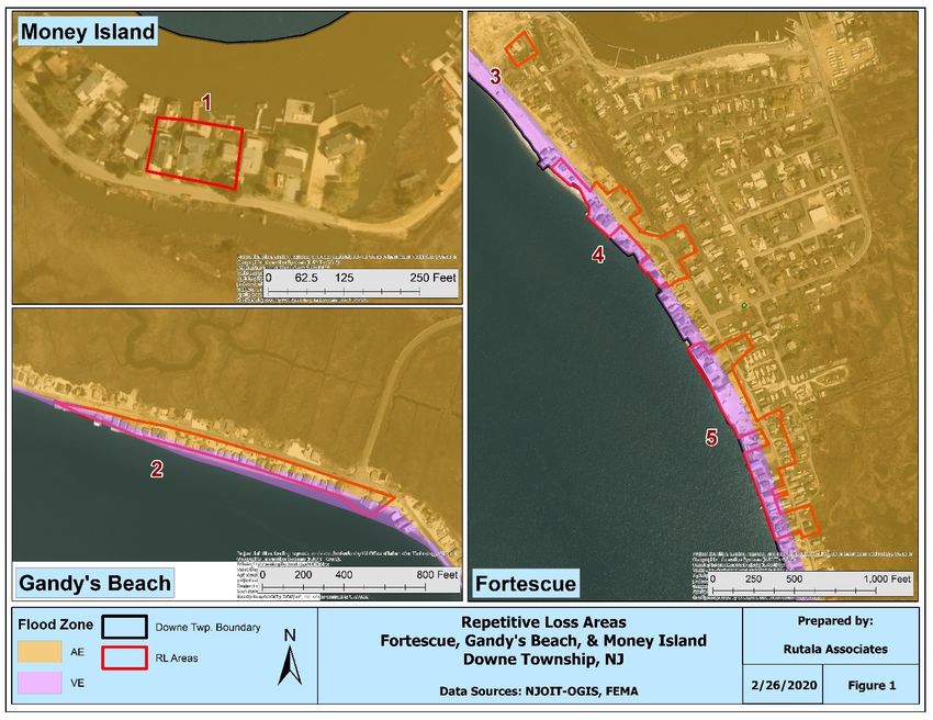
Figure 1: Area location map.
The Township of Downe has authorized the preparation of this Repetitive Loss Area Analysis
(RLAA) to study the areas where repetitive loss properties are located and to develop a plan
for future resiliency projects to protect these areas.
3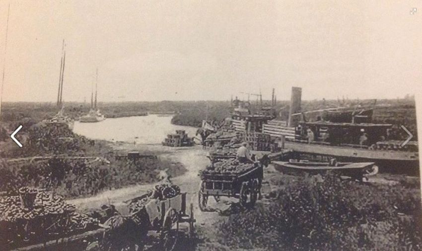
The Township received a detailed list of repetitive loss properties on January 14, 2021, from
the Federal Emergency Management Agency (FEMA). This list included 67 properties, which
after close evaluation only 28 are repetitive loss properties in Downe Township. The
remaining properties were not in located in the Township; purchased by the State of New
Jersey or a non-profit organization (NPO); the addresses did not exist; or the property is
vacant. The remaining 28 repetitive loss properties and surrounding areas were evaluated
in this study. FEMA was notified via AW-501 submissions of the 39 properties that should
be removed from the repetitive loss list.
This effort is being coordinated with the Cumberland County Multi-Jurisdictional Hazard
Mitigation Plan which is being updated in 2021. This plan will take a regional approach and
will identify all the major resiliency efforts planned for Downe Township. It is fortuities that
the County Plan and the Township Analysis is being completed simultaneously since they
will be coordinated to ensure that all the Township’s needs are identified. The primary
difference between the Hazard Mitigation Plan and the RLAA is that the former is a County-
wide, comprehensive plan completed in compliance with the FEMA hazard mitigation
planning process. The latter follows an abbreviated hazard mitigation planning process, and
covers discrete geographic areas defined by repetitive loss properties.
In addition to providing CRS points, the Hazard Management Plan and Repetitive Loss Area
Analysis has several benefits. The planning process entails intensive public outreach and
communication efforts to inform the public of flooding and the Township’s efforts to address
it. This maximizes public input and enables a useful perspective from which to address
flooding. Furthermore, the planning process allows a more detailed understanding of
flooding, including the identification of flooding hotspots and gaps in protection. The process
uses a multi-front and multi-disciplinary approach to mitigating flooding in the community.
Finally, the process will allow the Township to be more competitive for mitigation funding
by identifying specific projects in a plan and advancing conceptual planning, engineering,
and design work.
The scope of work contained herein includes all applicable requirements for planning
documents creditable by CRS. The “Repetitive Loss Area Analysis” will be used in the Hazard
Mitigation Assistance grant applications.

2 BACKGROUND
Downe Township was incorporated in 1798. The Township, which is more than three-
quarters of permanently preserved open space, is home to several historic mixed-use
villages such as Dividing Creek, Newport, Gandy’s Beach, Money Island and Fortescue.
Commercial and recreational fishing and boating are an important part of the way of life as
is environmental recreation. The township is a sanctuary for horseshoe crabs. Public
marinas, fishing and ecotourism are some of its key industries. Silica sand, the high-quality
silica sand that is ideal for making clear glass, is mined in Downe Township.

                                                                                              4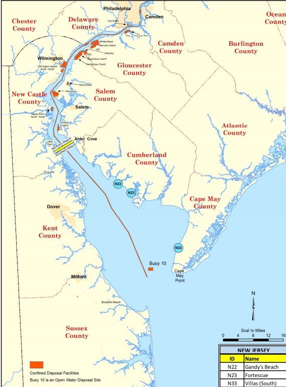
The lucrative commercial fisheries industry contributed to the prosperity of the Bayshore
communities in Cumberland County. For more than 300 years, New Jersey’s commercial
fishermen were catching, processing, and selling seafood to people around the world.
Because of an abundance of weakfish in Delaware Bay and Fortescue in Downe Township,
recreational fishing for weakfish was a major economic engine for the area. Beginning in the
1800s, scores of fishermen came to the Bayshore to seek weakfish, flounder, stripers, and
bluefish. By the early 1900s, Fortescue had proclaimed itself the “Weakfish Capital of the
World.”
At the turn of the 20th century oysters were the nation’s chief fishery product and the most
popular of all shellfish. Whole towns grew up around the oyster industry: including the
villages of Fortescue, Money Island, Gandy’s Beach, and Dividing Creek in Downe Township.
Cumberland County’s oyster enterprise elevated New Jersey to one of the four leading
oyster-producing states in the nation. By the second half of the 20th century, however, the
oyster crop was nearly wiped out by disease. The decline was precipitated in the 1950s by a
disease known as MSX and exacerbated in the 1990s by a parasite known as Dermo.
Table 1: Summary of NFIP flood claims in Fortescue, Gandy’s Beach and Money Island
       Annual Policy Claims
       Number of    Total Payout of
Year     Claims         Claims
2020           15   $ 229,781.57
2018            2   $    26,457.26
2016            1   $      4,208.07
2013            1   $      5,696.48
2012          119   $ 5,907,386.34
2011           17   $ 300,425.05
2010            3   $ 201,743.11
2008            1   $      1,312.78
2007            1   $    10,508.67
2006            1   $      5,631.64
2005            4   $    31,212.73
2003            1   $      2,066.65
2002            1   $      8,924.95
1998            1   $        986.06
1997            3   $    21,554.27
1996            2   $    15,819.05
1994            7   $    16,799.74
1993            4   $    18,966.21
1992           28   $ 175,965.57
1985           24   $ 260,962.25
       Total        $ 7,246,408.45

Downe is set amid pristine salt marshes, old-growth forests, waterways, and agricultural
areas. Downe has three of the last remaining Delaware Bayshore villages: Fortescue, Gandy’s
Beach, and Money Island. The Delaware Bayshore has been historically under-invested and
particularly subjected to volatile markets for natural resources. As noted above, throughout
the 19th and 20th century, the Township was a hub for economic activity in the form of oyster
farming and sand mining. With both industries in decline and much of the Township’s land

                                                                                           5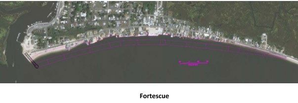
purchased for open space, Downe has a very narrow window of opportunity for economic
growth and rural development. Downe intends to capitalize on its accessible natural
resources (mainly its beautiful ecosystem) to drive growth in the form of research, fisheries,
and eco-tourism.
There are 24 repetitive loss properties and 4 severe repetitive loss properties. See Table 1
below for a list of National Flood Insurance Program (NFIP) flood claims in the past 35 years.
Hurricane Sandy, which made landfall in New Jersey on October 29, 2012, resulted in nearly
$6 million in NFIP flood claims. Please note that this estimate only accounts for the National
Flood Insurance Policy claims and does not include properties that were uninsured, items
that were not covered by policies, and damages incurred that were not claimed.
According to the FEMA data base as of January 31, 2021, there were 111 NFIP policies
holders in Downe Township, providing property coverage for $24,625,000 and paying
$496,525 in annual premiums. Downe Township has the highest number of NFIP policies
in Cumberland County.

3 STUDY METHODOLOGY, RESULTS, AND ANALYSIS
This analysis will examine areas defined by the Township that exhibit significant flood losses
and areas of low elevation that flood repetitively. The RLAA is a detailed, small-scale
mitigation plan for a repetitive loss area. It provides more narrow guidance on how to reduce
damage from repetitive flooding than a community-wide floodplain management or hazard
mitigation plan and focuses on more discrete geographical areas. Before beginning the RLAA
process, the community reviewed its repetitive loss list to determine if any properties have
been mitigated or incorrectly assigned to the community. Once the list is reviewed and the
necessary updates approved, the remaining unmitigated repetitive loss properties will form
the basis for the RLAA.

The five steps for an area analysis will evaluate each building in the repetitive loss area(s).

Step 1: Project Notification
Advise all the properties in the repetitive loss areas that the analysis will be conducted
and request their input on the hazard and recommended actions. The notice (or any
public document) cannot identify which properties are on FEMA’s repetitive loss list.
There are no restrictions on publicizing what properties are in repetitive loss AREAS that
have more than one property and there are no restrictions on publishing aggregate data,
such as how many properties received claims or the average value of those claims.
Community planning staff may share insurance claims information with the owner of the
property, but may not make it available to anyone else
   •   The notice can be sent to owners OR residents at the community’s discretion, as
       long as a representative of each property is notified.

                                                                                                  6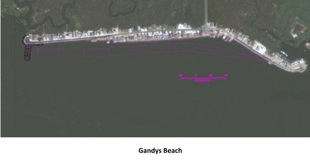
•   The notice cannot be done via a newspaper or newsletter notice or article.
   •   The notice will advise the recipients when and how copies of the draft report can
       be obtained and ask for their comments on the draft.

Step 2: Planning Coordination and Review
Contact agencies or organizations that may have plans or studies that could affect the cause
or impacts of the flooding. The agencies or organizations will be identified in the analysis
report.

Step 3: Site Inspection
Visit each building in the repetitive loss area and collect basic data.

   •   The site visit will collect data sufficient to do a preliminary determination of the
       cause of the repetitive flooding and of the mitigation measures that would be
       appropriate. This usually includes a review of drainage patterns around the
       building, the condition of the structure, and the condition and type of foundation.
   •   The person conducting the visit should not have to enter the property— adequate
       information should be collected from observations from the street.
   •   Floor elevations or historical flood levels are not required but can be helpful
       where available.
   •   The date for each building’s insurance claim can help identify the cause of flooding
       (e.g., rainfall or overbank flooding) and the amount of the claim can help
       determine the amount of damage. Note that, every year, each repetitive loss
       community is provided with a list of its historic insurance claims. This includes
       single-claim properties.

Step 4: Review Alternative Approaches
Review alternative approaches and determine whether any property protection
measures, or drainage improvements are feasible. The review will look at all of the
property protection measures that are appropriate for the types of buildings affected. A
review that looks only at drainage or structural flood control project alternatives is not
sufficient.

Step 5: Document Findings
A separate analysis will be conducted for each area. In general, separate reports are
preferred for each area, but in cases in which several areas have similar building and flooding
characteristics and similar mitigation measures are appropriate, the analyses can be
assembled into a single report. Each report will include:

   •   A summary of the process that was followed, including how the property owners
       were involved:
       o The problem statement with a map of the area affected. The statement and
          map may show individual properties or parcels, but cannot show which ones

                                                                                             7
are on FEMA’s repetitive loss list;
o A list or table showing basic information for each building, such as address,
foundation type, condition, and appropriate mitigation measures. This list
cannot include insurance data, such as how many claims have been paid for
that property. If the property owners responded to a survey, the survey
responses may be included (unless the community promised confidentiality);
o The alternative approaches that were reviewed; and
o Action items that include
Who is responsible for implementing the action?
When it will be done, and
How it will be funded.
“When it will be done” can be expressed in terms of a date, a set period of time
after another action is complete, after the next flood, etc. “How it will be
funded” could state that funding will be dependent upon receiving a grant,
provided that one or more suitable grant programs are specified to which
application(s) for funding will be made. The RLAA will be submitted to the
community’s governing body and made available to the media and the public.
If private or sensitive information (such as names or street addresses) is
included in the report, then a summary report(s) will be prepared for the
governing body, committees, media, and the public. The complete RLAA will
be adopted by the community’s governing body.
The following deliverables will be provided for the project:
a. A copy of the RLAA (see Step 5).
b. Documentation showing how the owners or residents of the areas were notified
(see Step 1).
c. Documentation showing how the analysis was made available to the media and
the public.
d. A copy of the resolution or other formal action by the governing body that adopts
the area analysis or accepts changes in subsequent updates.
4 COMMUNITY RATING SYSTEM (CRS)
In the United States, the National Flood Insurance Program (NFIP), which is managed by the
Federal Emergency Management Agency (FEMA), is the primary source of residential flood
insurance coverage. Established in 1968, the purpose of the NFIP is both to offer primary
flood insurance to properties with a high risk of incurring flood impacts and to reduce flood
risk by adopting floodplain management standards. The long-term goal of the NFIP is to
reduce the federal expenditure on disaster assistance following flood events. Insured
properties incurring repetitive flood losses, referred to as Repetitive Loss Areas, are the
8largest threat to the future viability of the NFIP where approximately 2 percent of policies
qualify for about 16 percent of the total claims over the life of the program (Horn, 2019). A
property is considered a repetitive loss area if an insured property incurs over $1,000 in
flood damages within a 10-year period. A property is considered a severe repetitive loss
property if it incurs four or more claims of more than $5,000 or at least two claims that are
greater than the property’s value. A property where the cost to repair the flood impacts are
greater than 50 percent of the value of the property is considered to be substantially
damaged. Once a property is classified as substantially damaged, it must be brought to the
same level of flood protection as a newly constructed property. The villages of Fortescue,
Gandy’s Beach, and Money Island currently have 146 active NFIP policies, 24 repetitive loss
properties, and four severe repetitive loss properties.
In an effort to try to protect the residents and businesses in Fortescue, Gandy’s Beach, and
Money Island, Downe Township is seeking to participate in the FEMA Community Rating
System (CRS). The CRS is a voluntary program from FEMA that benefits municipalities for
taking actions to reduce future flood damages. CRS communities are rated on a scale of 1-10
with communities rated Class 1 being the highest. Each additional class receive receives an
additional 5 percent reduction in NFIP flood insurance premiums. Communities can improve
their CRS rating by reducing flood impacts to existing structures, protecting new
construction above the minimum NFIP protection level, restoring natural floodplain
functions, helping gather flood data for an area, or helping residents obtain flood insurance
(FEMA, 2017).
This Repetitive Loss Area Analysis is being conducted as part of Activity 510 of the CRS
program to earn points toward a better CRS rating and contribute to an eventual Floodplain
Management Plan. In addition, the goal of this analysis is to identify areas of concern and
develop a plan to mitigate them to avoid future damages.
5 REPETITIVE LOSS AREA ANALYSIS
The CRS categorizes its communities with NFIP policies into three groups based on the
communities’ repetitive loss list.
Category A: A community with no repetitive loss properties or whose repetitive loss
properties have been mitigated.
Category B: A community with at least one, but less than 50 repetitive loss properties that
have not been mitigated.
a. Prepare a map of the repetitive loss area(s) (see Section 503),
b. Review and describe its repetitive loss problem,
c. Prepare a list of the addresses of all properties with insurable buildings in those areas,
and
9d. Undertake an annual outreach project to those addresses (see Section 504). A copy of
the outreach project is submitted with each year’s recertification.
Category C: A community with 50 or more repetitive loss properties that have not been
mitigated. A Category C community must
a. Do the same things as a Category B community, and
b. Prepare and adopt a repetitive loss area analysis for all repetitive loss areas or
prepare and adopt a floodplain management plan that includes full credit for planning
Step 5(c). Repetitive loss area analyses and floodplain management plans are
described under Activity 510 (Floodplain Management Planning).
The latest repetitive loss data for Downe Township indicates that there are currently 28
unmitigated repetitive loss properties located in the villages of Fortescue, Gandy’s Beach,
and Money Island. Therefore, Downe Township is considered a Category B Repetitive loss
community.
Repetitive Loss Areas in Downe Township were mapped using the FEMA CRS resource
entitled “Mapping Repetitive Loss Areas for CRS” published in October 2015. Using this
guidance, 28 repetitive loss areas were identified. These repetitive loss areas included all 28
repetitive loss properties, non-repetitive loss properties with historical flood claims, and
properties that share the same landscape positions or flood risk as the repetitive loss
properties. See Appendix A for a map of the Repetitive Loss Areas in Downe Township.
Section 510 of the 2017 CRS Coordinator’s Manual outlines the recommended process for
conducting a successful repetitive loss area analysis. The manual outlines the process in five
steps summarized below:
a. Advise all the properties in the repetitive loss area that an analysis of their area will
be conducted and request their input and recommendations.
b. Contact agencies and organizations that may have plans, studies, or projects that may
affect or be affected by the flooding in the area.
c. Visit each property identified in the repetitive loss area and collect basic data
d. Review alternatives approaches and determine whether any property protection
measures, or drainage improvements are feasible. This review shall consider all types
of property protection measures that are applicable to the area of interest.
e. Document the findings in a report summarizing the process that was followed, a
problem statement, a list of the basic information about each building, alternatives
that were considered, and a list of action items that illustrating how the project will
be executed.
In addition to the five basic planning steps outlines in the CRS Coordinator’s Manual, Downe
Township is responsible for fulfilling the following additional criteria to qualify for CRS
credit:
a. Downe Township must have at least one repetitive loss area delineated and mapped
in accordance with Section 503 of the CRS Coordinator’s Manual.
10b. A final Repetitive Loss Area Analysis Report must be submitted and adopted by
Downe Township and made available to the public.
c. Downe Township shall prepare an annual RLAA evaluation report and an updated
RLAA shall be completed in time for each CRS verification field visit.
5.1 STEP 1: PROJECT NOTIFICATION
Prior to the commencement of site visits, letters were mailed to all private landowners
within the repetitive loss areas to notify them of the upcoming study. In addition to the letter,
property owners were sent a survey asking for general information related to their property.
See Appendix B for an example of the letter and survey sent to property owners. A total of
108 letters were mailed to property owners on January 26, 2021. Copies of the letters are on
file at the Downe Township Municipal Complex located at 288 Main Street, Newport NJ
08345. Individual letters will not be shared with the public in accordance with the Privacy
Act of 1974.
5.2 STEP 2: PLANNING COORDINATION AND REVIEW
Downe Township reached out to 34 public and non-profit agencies that may have studies or
plans that may have an impact on flooding in the villages of Fortescue, Gandy’s Beach and/or
Money Island or may impact the areas identified in the repetitive loss area analysis. The
following studies, plans, and resiliency projects were identified and considered in this
analysis:
Table 2: List of agencies that may have studies or projects in the communities of
Fortescue, Gandy’s Beach, or Money Island
Agency Contact Name/# Notes Email
Madhuri Rodriguez, No response Madhuri.rodriguez@redcross.org
American Red Cross
Regional Director;
Shane Godshall, Habitat Received significant information Shane@littoralsociety.org
American Littoral
Restoration Coordinator; regarding the Fortescue Beach
Society
215-622-3705 Restoration Project.
Burt Lopez Received information regarding Bert.lopez@atlanticcityelectric.com
Atlantic City
three phase power to Gandy’s Beach
Electric Company
for sewer system.
Matthew E. Pisarski, No response mattpi@co.cumberland.nj.us
Cumberland County
Planning Director; (856)
Planning
453-2175
John Knoop, County Working jointly on many resiliency johnkn@co.cimberland.nj.us
Cumberland County
Engineer projects including the elevation of
Engineer
856.453.2192 the road to Money Island
Jim Manski, Deputy EM Received the County All Hazards jamesma@co.cumberland.nj.us
Cumberland
Director Mitigation Plan
County-OEM
(609) 455-8770 ext. 363
Delaware Bay Warren Hollinger, No response
Shellfish Council Chairman
Michael Moriarty, No response michael.moriarty@dhs.gov
Director, Region II
FEMA-Region 2
Mitigation; (347) 838-
0427
11Lisa Auermuller, No response auermull@marine.rutgers.edu
Jacques Cousteau
Assistant Reserve
NERR
Manager, 848-932-3474
National Fish & Claire Flynn, Grant No response Claire.flynn@nfwf.org
Wildlife Foundation Administrator
Betsy Nicholson, Mid- Received information regarding betsy.nicholson@noaa.gov
National Oceanic Atlantic Sub-Region, USGS gauges in the area.
Atmospheric Office for Coastal
Administration Management, 617-869-
9148
Jason Franklin, No response jason.franklin@noaa.gov
National Weather
Meteorologist-in-Charge,
Service
609-261-6600
Dan Kelly, Governor’s No response Daniel.kelly@nj.gov
Office of Rebuilding and
NJ Governor’s Office
Recovery
609.292.2584
Samuel Viavattine, No response Samuel.viavattine@dca.nj.gov
NJDCA – Sandy
Director
Recovery
609.984.2148
Dave Rosenblatt, Chief NJDEP partially funded bulkhead Dave.Rosenblatt@dep.nj.gov
NJDEP Climate and
Resilience Officer, improvements in Gandy’s Beach.
Flood Resilience
609.292.9236
Kimberly Springer, Office Received information regarding Kim.Springer@dep.nj.gov
NJDEP- Coastal
of Policy and Coastal mapping.
Management
Management; 609-292-
Program
2178
NJDEP- Natural and Raymond Bukowski, Discussed the transfer of the Ray.Bukowski@dep.nj.gov
Historical Assistant Commissioner; Fortescue marina to the Township.
Resources 609-292-3541
NJDEP – Blue Acres Fawn McGee, Director, Received a listing of Blue Acres Fawn.mcgee@dep.nj.us
Program Blue Acres Program purchased properties.
Andrew Hassall, Fisheries Received information regarding the Andrew.J.Hassall@dep.nj.gov
NJDEP – Bureau of
Biologist Nantuxent Creek dredging project.
Shellfish
856-785-0730
John H. Moyle, PE, State No response John.Moyle@dep.nj.gov
NJDEP-NFIP
NFIP Coordinator; (609)
Coordinator
292-2296
Michael Russo, Assistant Applied for funding to elevate the Michael.Russo@dot.nj.gov
NJDOT – Planning
Commissioner; 609-530- road to Money Island.
and Grants Adm
3640
Scott Douglas, Received information regarding the scott.douglas@dot.nj.gov
NJDOT – Office of
609.963.2104 Nantuxent Creek and possible
Maritime Resources
Fortescue Creek dredging projects.
Chris Testa, Mitigation Received NFIP and repetitive loss lpptestc@gw.njsp.org
NJOEM Unit Manager; 609-508- data
6557
Kathy Klein, Executive Received information regarding the kklein@delawareestuary.org
Partnership for the
Director living shoreline project along
Delaware Estuary
302.655.4990 ext. 102 Nantuxent Creek
Lauren Hurtt, Supervisor, Discussed gas service to Fortescue. lhurtt@sjindustries.com
South Jersey Gas Public Affairs; (609) 561-
9000 ext. 4181
Jennifer Marandino, Received information regarding jmarandino@sjtpo.org
SJTPO Executive Director, 856- 2050 Regional Transportation Plan
794-1941
Stevens Institute Jon Miller; 201.216.8591 No response jmiller@stevens.edu
12Steve Hafner Received information regarding steven.hafner@stockton.edu
Stockton Coastal
Nantuxent Creek and Fortescue
Research Center
Beach projects.
The Nature Patty Doerr; Received information regarding the Patricia.doerr@TNC.org
Conservancy 609.861.0600 Nantuxent Creek project.
US Army Corps – Peter Blum; Discuss the upcoming beach Peter.r.blum@usace.army.mil
Philadelphia 215.656.6585 replenishment project in Gandy’s
District Beach and Fortescue.
Steve Mars/Eric Received information regarding two Eric_schrading@fws.gov
US Fish and Wildlife Schrading, Senior Fish shoreline project at Gandy’s Beach
Service and Wildlife Biologist and Nantuxent Creek.
609-646-9310x5267
USDA- Natural Hilary Trotman, Civil Received information regarding hilary.trotman@nj.usda.gov
Resources Engineer easement restoration.
Conservation (856) 205-1225, ext. 3
Service
Peter Straub, Dean, No response Peter.straub@stockton.edu
Stockton University School of Natural
Sciences and Math
5.2.1 Resiliency Planning Documents
5.2.1.1 Cumberland County Delaware Bayshore Recovery Plan, 2013
This Cumberland County Delaware Bayshore Recovery Plan is the result of a partnership
between the Cumberland County’s Bayshore communities and FEMA’s Community Recovery
Assistance team. This plan is a guide for the Cumberland Bayshore elected officials,
municipal staff, non-governmental organizations, local stakeholders, and the community at
large to use in their longterm recovery efforts. The process included gathering many projects
already scoped out by the county and municipalities, non-profit collaborative initiatives,
Rising Tides Forum, and other relevant resiliency efforts. These projects were then
inventoried, gaps were analyzed, and new projects were written where important issues
were not yet addressed. This Cumberland County Delaware Bayshore Recovery Plan includes
26 recovery projects, developed, and prioritized by the New Jersey Delaware Bayshore Long-
Term Recovery Committee. It serves as a critical tool demonstrating to potential resource
providers the communities’ commitment to recovery and organizational capacity. The
Cumberland County Bayshore Recovery Plan was released in December 2013 in the wake of
the massive damage caused by Hurricane Sandy. This document served as the culmination
of a four-month planning effort from federal, state, local, non-profit partners, and
stakeholders to develop a unified community vision. The plan outlines the vision, recovery
goals, and a list of prioritized projects to ensure future resiliency of the area.
Vision
• Sustain and stabilize the environment and economy by supporting existing
businesses and promoting tourism;
• Empower families who live and work in the Bayshore communities to have a balanced
approach to developing and protecting the Delaware Estuary system;
• Develop new business and tourism ventures; and
13• Protect important and often vulnerable natural habitats.
Project Summaries and Task Forces:
Intergovernmental Relations
• Formation of a Bayshore Council: This council would inform elected officials about the
continuing needs of the Bayshore region.
• Bayshore Resiliency and Outreach Education: The goal of this project is to educate the
public about issues of sea level rise, sustainable development, coastal erosion, and
resiliency.
Tourism and Economic Development
• Business Retention and Recruitment Plan: The goal of this project is to create a focused
economic recovery plan for Cumberland County’s Delaware Bayshore to make the
region a desirable place for future generations of Bayshore families to commit to
planting roots and raising their families here.
• Eco-Tourism Task Force: A group formed to continue the focus of the region on eco-
tourism and help build infrastructure to support it such as revitalizing businesses,
restaurants, and shops in the area to continue to attract a tourist population.
• Bayshore Marketing and Destination Plan: This plan will provide a road map for
developing Cumberland County’s Bayshore community as a nationally recognized
destination.
• Historic Bayshore Oyster Industry Revitalization: This project will expand the shell
planting program by $500,000 to $1 million annually for a limited period.
Infrastructure Project Summaries
• Emergency Generators: This project will provide a safe and sustaining emergency
shelter to accommodate people evacuated from areas impacted by a storm.
• Public Water Supply Feasibility Study: This project will assure that each resident,
business, and visitor have access to a safe and secure water supply, and it will support
the sustainability of homes and businesses in the area.
• Road Elevations and Improvements: This project will improve coastal evacuation and
public safety by elevating certain local, county and state roads to prevent flooding
during high tides and storm events. The Plan specifically identifies Gandy’s Beach
Road, Fortescue Road, and County Route 553 in Downe Township for elevation.
• Wastewater Management Feasibility Study: The Plan recommended the provision of
wastewater infrastructure necessary to revitalize the economy of the Delaware
Bayshore area in Cumberland County. A feasibility study has been completed for
Fortescue and Gandy’s Beach as a result of this recommendation that has led to the
planned construction of a community sewer system.
Shoreline Protection and Coastal Management Projects
• Beach and Dune Restoration: This project seeks technical assistance and financial
resources to plan, design and implement a beach and dune restoration project for the
entire Delaware Bayshore area in Cumberland County. Specially, the Plan
recommends restoring beaches and dunes along the developed Bayshore
14communities in Downe Township (Fortescue, Gandy’s Beach and Money Island) as a
first step in reconstructing vibrant, resilient coastal communities in Cumberland
County.
• Construct/Repair Bulkheads and other Structures: The goal of this project is to protect
residential and commercial property. In addition, it will prevent erosion of river and
creek banks where commercial and recreational activities are present. It will also
stabilize other water access points and hard structures damaged by Sandy. The Plan
included the following list of structures Downe Township in need of repair or
construction:
o Money Island - Provide bulkhead replacement at the end of Gandy’s Beach
Road ($530,000)
o Fortescue - Provide bulkhead at Myers Marina and New Jersey Avenue
($125,000)
o Fortescue - Replace Bulkhead at Frank Carpino Delaware Bay Campground,
Secure Public Access ($750,000)
o Fortescue - Bulkhead Replacement at Fortescue Captain’s Association Marina
(New Jersey State Marina) ($2.8 M)
o Dividing Creek Improvements (Backfill; Bulkhead - New one needed) (Maple
Avenue) ($6.15 M)
o Fortescue Improvements (Bulkhead at Marina Inlet; Rock Jetty [800 feet];
Beach Replenishment coming from other projects) ($3.93 M)
o Gandy’s Beach Improvements (Bulkhead; Rock Jetty [200 feet]; Beach
Replenishment coming from other projects)
o Money Island Improvements (Bulkhead; Rock Jetty [300 feet]; Beach
Replenishment coming from other projects) ($2.4 M.)
5.2.1.2 Downe Township Today & Tomorrow, 2014
This report was incorporated into the Four County Multi-Jurisdictional Hazard Mitigation
Plan to identify resiliency projects in Downe Township. The report identifies a wide variety
of projects including:
• Maple Street, Dividing Creek Improvement Plans – storm damage has compromised
the safety of road shoulders, paving, and guard rails.
• Gandy’s Beach Improvement Plans
o Water & Sewage Treatment Facility
o Jetty to Protect Marina & Cove
o Bulkhead Repair
o Fishing Area
o Bay Access for Boating & Fishing
o Parking
o Public Restrooms
• Nantuxent Creek Improvement Plans
o Parking
o Elevated Boardwalk Wildlife Viewing Areas
o Bulkhead Repair
15o Fishing Area
o Public Restrooms
o Scenic Overlook
• Money Island Improvement Plans
o Water & Sewage Treatment Facility
o Jetty to Protect Marina & Cove
o Bulkhead Repair
o Bulkhead Promenade & Fishing Area
o Bay Access for Boating & Fishing
o Parking
o Public Restrooms
• Fortescue Improvement Plans
o Water and sewage treatment facility
o Jetty to protect marina and cove
o Bulkhead repair
o Bulkhead promenade and fishing area
o Bay access for boating and fishing
o Bay kayak access
o Parking
o Public restrooms
5.2.1.3 Downe Township Master Plan Reexamination Report, 2016
The Downe Township Master Plan Reexamination Report states stresses the need for
infrastructure and investment to meet the demands of the coastal environment. It notes the
pressing demands for coastal protection, wastewater treatment, and dredging.
5.2.1.4 Four County Multi-Jurisdictional Hazard Mitigation Plan, 2016
The Mitigation Plan for Four New Jersey Counties incorporates input from approximately
ninety (90) participating counties and municipalities in Camden, Cumberland, Gloucester,
and Salem Counties. The Plan is an update and expansion of the South Delaware Valley
Region Multi-Jurisdictional Hazard Mitigation Plans that were adopted by all four counties
and approved by the Federal Emergency Management Agency in 2010 and 2011.
The Regional Hazard Mitigation Plan includes Annexes that contain detailed background
information for these three focus areas and additional reference materials for the
implementation of the NJ4 HMP. The County and Municipal Appendices include specific
information for these same three main focus areas for each of the participating counties and
municipalities. Detailed tabulations are included in these Appendices for critical facilities,
status of past mitigation activities, and proposed mitigation measures.
During the Municipal Working Group Work Sessions, the Municipal Working Groups
identified some SDVR HMP mitigation measures as well as new areas of concern as
mitigation measures where implementation requires participation or leadership from other
16levels of government, including county, state, and federal agencies. These multi-
jurisdictional mitigation measures are included in the Table below. Many of these projects
refer to the Downe Township Today & Tomorrow report for details.
Coastal Municipal
Downe MJ-1 Fortescue Erosion and Goal #4 Both OEM,
Township Area Sea Level Downe
Improveme Rise / Flood Township
nt Plans8, 9. (Storm Initiative
Surge & Partners
Tidal)
Dividing Coastal Municipal
Downe MJ-2 Creek / Erosion and Goal #4 Both OEM,
Township Maple Sea Level Downe
Avenue Rise / Flood Township
Improveme (Storm Initiative
nt Plans10, Surge & Partners
11. Tidal)
Coastal Municipal
Downe MJ-3 Money Erosion and Goal #4 Both OEM,
Township Island Sea Level Downe
Improve Rise / Flood Township
ment (Storm Initiative
Plans12. Surge & Partners
Tidal)
Coastal Municipal
Downe MJ-4 Gandy’s Erosion and Goal #4 Both OEM,
Township Beach Sea Level Downe
Improveme Rise / Flood Township
nt Plans13 (Storm Initiative
Surge & Partners
Tidal)
Coastal Municipal
Downe MJ-5 Nantuxent Erosion and Goal #4 Both OEM,
Township Creek Sea Level Downe
Improvemen Rise / Flood Township
t Plans14 (Storm Initiative
Surge & Partners
Tidal)
Coastal
Downe MJ-6 Newport Erosion and Goal #4 Both Municipal
Township Neck Road Sea Level OEM,
Rise / Flood Cumberland
17(Storm County
Surge & DPW
Tidal)
8 See Downe Initiative - Page 110.
9 Mitigation Measures MJ-1 and MJ-2 part of HMGP Grant Application Project #315 under DR 4086, Hurricane
Sandy. Total grant application for $8,000,000.
10 See Downe Initiative - Page 114.
11 Mitigation Measure MJ-4 part of HMGP Grant Application Project #1557 under DR 4086, Hurricane Sandy.
Total grant application for $1,300,000.
12 See Downe Initiative - Page 123.
13 See Downe Initiative - Page 128.
14 See Downe Initiative - Page 132.
5.2.1.5 Gandy’s Beach Beachfront Sustainability Project, 2017
The purpose of the Gandy’s Beach Beachfront Sustainability Project, funded by the National
Fish & Wildlife Foundation, was to develop a plan to: (1) protect and enhance the beachfront
to increase the community’s resiliency to coastal storms and sea level rise; (2) enhance the
habitat for horseshoe crabs and red knots; and (3) increase the project life of a proposed U.S.
Army Corps of Engineers (USACE) beach fill. The project involved the evaluation of
structural and nonstructural options that would help increase the sustainability of the
Gandy’s Beach beachfront. Significant participation from stakeholders, such as Downe
Township, USACE, NFWF, and the NJDEP, was facilitated during each project task. As part of
the project scope of work, Mott MacDonald performed:
• bathymetric and topographic surveys;
• analysis of sediment samples and soil borings;
• investigation of existing coastal and environmental conditions with numerical
modeling of nearshore waves, sediment transport, and shoreline change;
• a two-phase alternative analysis;
• initial and final design; and
• development of a “5-year” engineered beach design with a maintenance and
monitoring plan.
The breakwater structures have been designed to be stable under normal conditions and
withstand a 50-yr storm with minor damage. The design also accounts for the projected 50-
yr. SLR increment. The structures were designed with a project life of 50 years.
It is anticipated that the structures will require periodic maintenance due to normal wear
and tear, as well as repair to any damage caused by a storm event. The structures were
designed based on topographic and hydrographic surveys performed in November 2015.
Topographic and bathymetric conditions vary with time; thus, it is recommended that
additional topographic and hydrographic surveys are performed prior to constructing the
headland breakwater structures or beach fill. Any variation in topography or bathymetry
may result in different footprint sizes and material quantities than those shown in the
construction drawings. Similarly, it is recommended that proper overfill calculations be
performed prior to implementing the beach fill to determine the required fill volume.
18Vibracore borings were performed in April 2017, and the results were used to determine the
stability of the bay bottom and the required foundation for the headland breakwater
structures. If there is a significant lag time between the date the boring tests were performed
and when the structures are to be constructed, or if the location of the structures change, or
if any events occur that could alter the composition of the bay bottom within this period, it
is recommended that updated boring tests are performed to ensure the current design is
appropriate for the new conditions.
As per the project goals, the breakwater system was designed to work with the USACE beach
fill template. The structures will also work with the “5-year” engineered beach fill, in the
event that option is available for implementation prior to the USACE beach fill. If a beach fill
of any other size/dimensions is implemented with the structures, their performance will
vary and/or may not meet the expectations described within this report. If it is the case that
a beach fill of a different size is to be implemented, a design review of the headland
breakwater system is recommended.
5.2.2 Ongoing Resiliency Projects
5.2.2.1 Nantuxent Creek Dredging and Living Shoreline
The NJ Division of Fish & Wildlife is permitting the maintenance dredging of the Nantuxent
Creek entrance channel to Delaware Bay, ana commercial vessel dockage area upstream
from Nantuxent Creek. The Nantuxent Creek entrance channel to Delaware Bay, although
historically utilized by transiting marine vessels, is being proposed as a new State Channel
(#212), to be included in the State of New Jersey's maintenance dredging program managed
by the NJDOT’s Office of Maritime Resources. All resultant dredged material will be
beneficially re-used within the Delaware Bay system to restore the eroded Money Island
shoreline, enhance habitat, and improve ecological and community resilience.
The Partnership for the Delaware Estuary (PDE) installed a living shoreline in Nantuxent
Creek as part of their Delaware Estuary Living Shoreline Initiative (DELSI). The photos in
Figure 1 show a before and after image of their living shoreline project.
Contact: Josh Moody, jmoody@DelawareEstuary.org
5.2.2.2 Gandy’s Beach Preserve Living Shoreline
The Nature Conservancy (TNC) installed a living shoreline between the communities of
Money Island and Gandy’s Beach that is now referred to as the Gandy’s Beach Preserve. The
goal of this project was to increase the resiliency of tidal marsh, beach, and oyster reef
habitats to the impacts of sea level rise and more frequent severe storm events. See the map
in Figure 3 for a more detailed view of the projects
Contact: Patricia Doerr - pdoerr@TNC.org
19Figure 1: Photo of Nantuxent Creek before and after living shoreline
5.2.2.3 NJDEP Blue Acres Land Acquisition Program
The NJDEP Blue Acres Program was created after Hurricane Sandy in an attempt to buyout
properties that are located within flood prone areas. NJDEP has $300 million in federal
funding to purchase nearly 100 homes at their pre storm market prices. Once purchased, the
structures are removed from the property and the area becomes preserved open space. As
of February 8, 2021, a total of 34 properties in Downe Township were purchased through
the NJDEP Blue Acres Program. See Table 1 below for a list of properties that were purchased
through the Blue Acres Program.
Table 3: List of properties purchased by NJDEP through its Blue Acres Program as of
February 8, 2021
Town Offer Number Address Closing Date
Downe 0604-0011 150 & 152 Bayview Road 07/22/16
Downe 0604-0002 177 Bayview Road 08/01/16
Downe 0604-0027 148 Bayview Road 08/01/16
Downe 0604-0013 142 Bayview Road 08/31/16
Downe 0604-0029 134-136 Bayview Road 09/09/16
Downe 0604-0018 102 Bayview Road 09/12/16
20Downe 0604-0030 179 Bayview Road 09/22/16
Downe 0604-0032 246 E. Nantuxent Drive 09/27/16
Downe 0604-0022 162 Bayview Road 10/12/16
Downe 0604-0026 124 Bayview Road 10/17/16
Downe 0604-0016 144 Bayview Road 12/15/16
Downe 0604-0006 118 & 120 Bayview Road 12/28/16
Downe 0604-0036 154 & 156 Bayview Road 12/22/16
Downe 0604-0031 138 Bayview Road 01/10/17
Downe 0604-0007 164 Bayview Road 03/22/17
Downe 0604-0034 158 Bayview Road 03/30/17
Downe 0604-0021 122 Bayview Road 06/07/17
Downe 0604-0041 250 E Nantuxent Drive 10/24/17
Downe 0604-0037 160 Bayview Road 03/29/18
Downe 0604-0043 181 Bayview Road 03/29/18
Downe 0604-0023 218 Nantuxent Drive 06/27/18
Downe 0604-0019 146 Bayview Road 09/06/18
Downe 0604-0020 216 Nantuxent Drive 09/05/18
Downe 0604-0008 116 Bayview Road 10/12/18
Downe 0604-0009 114 Bayview Road 10/12/18
Downe 0604-0028 248 E Nantuxent Drive 12/05/18
Downe 0604-0001 180-182 Bayview Road 06/04/20
Downe 27
Downe #2 FEMA 0604-0099 284 Nantuxent Dr 03/16/20
Downe #2 FEMA 0604-0064 292 Nantuxent Drive 05/28/20
Downe #2 FEMA 0604-0094 280 Nantuxent Drive 07/17/20
Downe #2 FEMA 0604-0078 282 Nantuxent Drive 09/09/20
Downe #2 FEMA 0604-0072 316 Nantuxent Drive 10/06/20
Downe #2 FEMA 0604-0068 300 Nantuxent Drive 12/28/20
21Downe #2 FEMA 6
Downe #2 (Blue Acres Fund) 0604-0066 346 Nantuxent Drive 06/30/20
Downe #2 (Blue Acres
1
Fund)
TOTAL CLOSINGS 34
5.2.2.4 Nantuxent Creek Channel Dredging and Living Shoreline Project
The NJ Bureau of Shellfisheries, Stockton University, NJDEP Blue Acres Program, and
Delaware Bay Section of the NJ Shellfisheries Council have applied for dredging permits for
New Jersey Department of Transportation, Bureau of Maritime Resources (NJDOT) to dredge
the Nantuxent Creek Channel to improve navigation for the oyster dredge fishery and other
boat traffic. This dredging project is being planned in conjunction with another proposed
Blue Acres beach nourishment project on Nantuxent Beach that will help build up the eroded
shoreline. The sediments dredged from Nantuxent Channel are proposed to be placed on
Nantuxent Beach, which includes several properties within the placement site.
Once the sand is placed along the Bayview Road shoreline the Blue Acres project will add
some additional features to enhance habitat, ecological and community resilience as part of
their post Sandy FEMA acquisition, demolition, and restoration project for flood prone and
storm damaged properties along Bayview Road at Money Island. The additional restoration
as part of the Blue Acres program is under development.
Andrew Hassall, Fisheries Biologist
Bureau of Shellfisheries, Delaware Bay Office
1672 E. Buckshutem Road, Millville, NJ 08332
Phone: (856) 785 – 0730
5.2.2.5 Fortescue Beach Restoration - American Littoral Society Project
ALS has proposed a project at Fortescue that included a series of rock breakwaters and
oyster reefs at the south end of Fortescue, just outside the limits of the Army Corps beach
replenishment project. The beach template is similar with a dune. Offshore reef structures
will be installed to attenuate wave energy and enhance horseshoe crab spawning and Red
Knot foraging on the beach. Continued public access is presumed. This project has been
funded and currently permits are being pursued.
Fortescue beach was heavily impacted by Superstorm Sandy, removing sand and scattering
rubble along the beach destroying horseshoe crab spawning habitat and leaving the
subsequent marshes and communities exposed. In 2014, the ALS restored the southern
portion of Fortescue beach by removing the rubble and replacing the lost sand. In January
2016, Delaware Bay beaches were hit with another crippling storm, nor’easter Jonas, leaving
Fortescue beach in desperate need of sand replenishment and further protection and
restoration.
22With this project, the ALS team proposes to build protective oyster reef breakwaters based
on previous work and to construct newly designed hybrid breakwaters that will add
additional habitat while avoiding any danger of horseshoe crab impingement, a common
fault of similar structures. Hybrid breakwaters will be placed closer to the portion of the
beach with the greatest wave energy and the area of greatest sand loss. The breakwaters will
be 100 ft. in length, 32 ft. wide and 9 ft. tall and 100 ft. from the high tide line. These
breakwaters will be designed to withstand strong winds and waves from storm events
providing the most protection to this beach and the community.
The hybrid breakwaters will add more spawning habitat with the accumulation of sand. This
project will modify the littoral transport in a predictable way to ensure beach restoration
and coastal protection function according to design. These sheltered waters will provide
optimal breeding habitat for horseshoe crabs because beaches will be protected from
breaking waves in nearly all-weather events. The sheltered water will also prevent crabs
from overturning in breaking waves, a source of considerable mortality for crabs.
Oyster reef breakwaters will also improve the ecological profile at the site, extending down
the beach in two rows of 30 blocks each measuring 5 x 10 ft. and 50 ft. apart. These smaller
breakwaters will encourage shoal formations behind the structures. The ALS project team’s
work in previous years has proved that shoals may be as important to crabs as beaches,
allowing them to lay eggs at great density on shoals. Shoals tend to produce greater surface
egg availability because they are washed by the tide more frequently making them important
foraging habitat for shorebirds allowing them to fee throughout the tide cycle. This is
essential to fast weight gain for red knots needing to gain sufficient weight to make the final
leg of their migration to their breeding grounds.
Breakwaters will be constructed to allow natural easy movement of horseshoe crabs up the
beach for spawning and back to the water with the tide. The construction of the breakwaters,
oyster reef breakwaters, and the gaps between them will be adjusted to optimize the
protection afforded to the beach and encourage sand accumulation according to our most
recent adaptive management monitoring.
The outer surface of the hybrid breakwaters is comprised of single-sized stone designed for
a given level of wave action. Smaller, quarry-run, stones comprise a core. All materials used
for oyster reef breakwaters will be a suitable substrate for oyster colonization and, based on
our teams’ previous experience constructing and monitoring oyster reefs and in consultation
with members of the local oyster industry, we expect set of natural oysters and adequate
survival for the breakwater to have a permanent oyster population.
The hybrid breakwaters will be underlaid with Tensar mats. Tensar fabric prevents fine
materials from migrating up through the stone and prevents settling. This will provide a solid
foundation for the breakwaters to ensure longevity. Mat dimensions will be specified based
on breakwater designs.
23Contact:
Shane Godshall, Habitat Restoration Coordinator
American Littoral Society
Cell: 215-622-3705
www.littoralsociety.org
5.2.2.6 Fortescue & Gandy’s Beach Wastewater Treatment System
To reduce the threat of the discharge of untreated sewage effluent into surrounding areas a
community-based sewer service project is being constructed. The proposed sanitary sewer
infrastructure that will serve the existing homes and vacant developable properties in the
sewer service area comprising the villages of Fortescue (including Raybin’s Beach), Gandy’s
Beach, and the Fortescue Park/Heritage Hill Estates mobile home park. The project will
remove approximately 423 developed properties from using individual onsite wastewater
treatment and disposal systems (septic systems) and eliminate the risks of indirect and
direct discharge of un-treated wastewater into the surrounding wetlands and waters of the
State while providing for economic development. Funding from NJDEP, US Department of
Agriculture, New Jersey Environmental Trust, and NJ Department of Transportation is being
used to leverage this project. The Cumberland County Board of Commissioners has
committed to back the financing of this project. The project is designed to serve 333
properties in Fortescue and 90 properties in Gandy’s Beach. The project is currently in the
permitting phase and construction is planned to start in 2022.
This project is a once-in-a-generation opportunity to provide critical infrastructure to one of
the last Delaware Bayshore communities in New Jersey and has resulted from an
unprecedented effort and collaborative partnership between local, county, state, and federal
agencies as well as vociferous advocacy on the part of the Township and its people.
The plant will have a capacity of 130,000 gpd. The proposed method of treatment to achieve
the required effluent discharge limits is a filtration system provided by Alfa Laval. The
treatment plant will include a 30,000-gallon influent chamber, 81,250-gallon aeration
chamber, 24-ft diameter mechanical clarifier, a 20,000-gallon sludge chamber with 17 days
of sludge storage, and a tertiary cloth filter.
In 2021, the Township plans to apply for a FEMA BRIC Grant for the installation of two
permanent emergency generators for the Fortescue-Gandy’s Beach Wastewater Collection
and Treatment Project. One generator will be located at the treatment plant in Fortescue and
the other will be located at the pump station in Gardy’s Beach. The Gandy’s Beach generator
will be powered by diesel fuel and the Fortescue generator will be powered by natural gas;
they are sized to only support the sewer operation. The generators will be designed and
constructed in accordance with ASCE-24-14 or latest version, if applicable. The design and
construction will be complete in full compliance with all applicable federal, state, and local
floodplain and land use laws and regulations including 44 CFR 60.3 (floodplain management
criteria). Both generates will be elevated above the 500-year flood level.
245.2.2.7 Home Elevations - FEMA
Downe Township applies for FEMA Flood Mitigation Assistance Grants each year on behalf
of its property owners to secure funding for home elevations. FEMA provides 75 percent
grants for any property that has NFIP flood insurance. FEMA funds is increase to 90 percent
for repetitive loss properties and 100 percent for sever repetitive loss properties. FEMA
funding is limited to eligible cost which is strictly limited to the basic cost to elevation the
home.
5.2.2.8 South Cove Road Seawall Embankment – FEMA funded $1.3M
A 1,200 lf embankment repair is planned. The project includes a concrete rubble berm, and
a 12-inch-thick concrete slurry cap on top of the concrete rubble.
5.2.2.9 New Jersey Avenue Seawall Cap Walkway in Fortescue – FEMA funded $803,000
Concept plans call for a 9-foot public walkway, with railings and path lighting. Access to the
walkway will be provided in proximity to a future restroom adjacent to the seawall on the
opposite side of New Jersey Avenue. Two access points will be stairs and one access point
will need ADA requirements. Access points to the soon to be restored beach is not included
in this scope.
5.2.2.10 Delaware River Dredging Material Utilization (DMU) Project - $288 Million
The USACE Philadelphia District conducted the Delaware River Dredged Material Utilization
and Beneficial Use Opportunities Study. Approximately 3,000,000 cubic yards of sediment
are dredged from the Delaware River. Essentially all the sediment is removed from the
estuary system and placed in upland Confined Disposal Facilities. This study explored
25You can also read