Leveraging the Interdependencies Between Barrier Islands and Backbarrier Saltmarshes to Enhance Resilience to Sea-Level Rise
←
→
Page content transcription
If your browser does not render page correctly, please read the page content below
ORIGINAL RESEARCH
                                                                                                                                        published: 07 September 2021
                                                                                                                                      doi: 10.3389/fmars.2021.721904

                                            Leveraging the Interdependencies
                                            Between Barrier Islands and
                                            Backbarrier Saltmarshes to Enhance
                                            Resilience to Sea-Level Rise
                                            Christopher J. Hein 1* , Michael S. Fenster 2 , Keryn B. Gedan 3 , Jeff R. Tabar 4 ,
                                            Emily A. Hein 5 and Todd DeMunda 6
                                            1
                                             Department of Physical Sciences, Virginia Institute of Marine Science, William & Mary, Gloucester Point, VA, United States,
                                            2
                                             Environmental Studies Program/Geology, Randolph-Macon College, Ashland, VA, United States, 3 Department of Biological
                                            Sciences, Columbian College of Arts & Sciences, George Washington University, Washington, DC, United States, 4 Stantec,
                                            Williamsburg, VA, United States, 5 Office of Research and Advisory Services, Virginia Institute of Marine Science, William &
                                            Mary, Gloucester Point, VA, United States, 6 Stantec, Rockledge, FL, United States

                            Edited by:
                   Nicoletta Leonardi,      Barrier islands and their backbarrier saltmarshes have a reciprocal relationship: aeolian
                University of Liverpool,
                                            and storm processes transport sediment from the beaches and dunes to create and
                      United Kingdom
                                            build marshes along the landward fringe of the island. In turn, these marshes exert a
                         Reviewed by:
                           Jorge Guillen,   stabilizing influence on the barrier by widening the barrier system and forming a platform
 Consejo Superior de Investigaciones        onto which the island migrates, consequently slowing landward barrier migration and
               Científicas (CSIC), Spain
                     Christian Schwarz,
                                            inhibiting storm breaching. Here, we present a novel framework for applying these
 University of Delaware, United States      natural interdependencies to managing coastal systems and enhancing barrier-island
                   *Correspondence:         resilience. Further, we detail application of these principles through a case study of the
                    Christopher J. Hein
                                            design of a marsh creation project that showcases the interdisciplinary engagement
                        hein@vims.edu
                                            of scientists, engineers, stakeholders, and policymakers. Specifically, we describe: (1)
                    Specialty section:      the ecologic, sedimentologic, stratigraphic, and morphologic data obtained from the
          This article was submitted to
                                            southern 4 km of Cedar Island (Virginia, United States) and nearby backbarrier tidal
            Coastal Ocean Processes,
                a section of the journal    channels, tidal flats, and flood-tidal deltas, and (2) the use of those data to develop an
           Frontiers in Marine Science      engineering and design plan for the construction of a high (46 ha) and low (42 ha)
           Received: 07 June 2021           fringing marsh platform located behind the island, proximal to a former ephemeral
        Accepted: 04 August 2021
     Published: 07 September 2021
                                            inlet. Additionally, we chronicle the process used to narrow five initial alternative
                               Citation:
                                            designs to the optimal final plan. This process involved balancing best-available
     Hein CJ, Fenster MS, Gedan KB,         existing science and models, considering design and financial constraints, identifying
   Tabar JR, Hein EA and DeMunda T
                                            stakeholder preferences, and maximizing restoration benefits of habitat provision and
                 (2021) Leveraging the
   Interdependencies Between Barrier        shoreline protection. Construction of this marsh would: (1) provide additional habitat
 Islands and Backbarrier Saltmarshes        and ecosystem benefits, (2) slow the rapid migration (up to 15 m/yr at present) of the
   to Enhance Resilience to Sea-Level
       Rise. Front. Mar. Sci. 8:721904.
                                            barrier island, and (3) hinder island breaching. Ultimately, this project – presently at the
     doi: 10.3389/fmars.2021.721904         final design and permitting stage – may enhance the storm and sea-level rise resilience

Frontiers in Marine Science | www.frontiersin.org                                  1                                       September 2021 | Volume 8 | Article 721904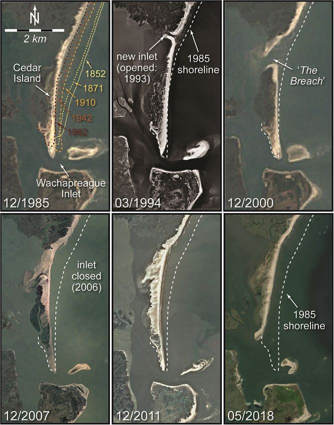
Hein et al.                                                                                                                Cedar Island Marsh Creation Project

                                            of the island, backbarrier marshes and lagoons, and the mainland town community; and
                                            provide an example of a novel science-based approach to coastal resilience that could
                                            be applied to other global barrier settings.
                                            Keywords: saltmarsh restoration, barrier islands, ecogeomorphology, coastal resilience, tidal inlet, overwash

INTRODUCTION                                                                       several decades (Figure 2B). This configuration mimics other
                                                                                   islands in the Virginia Barrier Island chain (e.g., Metompkin),
Coastal saltmarshes are long recognized for their ability to                       where the presence or absence of backbarrier fringing marsh
denitrify coastal waters; serve as habitat for birds, fish, and                    influences shoreline offsets along individual islands (Walters
invertebrates; store coastal blue carbon; attenuate storm wave                     et al., 2014). An additional driver of accelerated migration along
energy; reduce coastal erosion; and shelter mainlands from                         southern Cedar Island at this location is repeated storm-induced
flooding (e.g., Howes et al., 1996; Pennings and Bertness, 2001;                   breaching (Figure 3).
Shepard et al., 2011; Fagherazzi, 2014; Leonardi et al., 2018; Najjar                  We detail the conceptual foundation, design approach, and
et al., 2018). Backbarrier marshes, particularly those situated                    preliminary engineering design plans – along with the field and
directly landward of barrier islands, provide an additional                        laboratory data collection and analysis that underpin these –
and largely underrecognized function: they help to naturally                       for the creation of 88 ha of fringing marsh designed to prevent
stabilize fronting islands. By filling accommodation (the three-                   future erosion and breaching of this vulnerable reach. Serving
dimensional and subaqueous volume between the lagoon floor                         as a full-scale validation of modeled island-marsh couplings
and mean high water available for sediment to accumulate)                          (Walters et al., 2014; Lorenzo-Trueba and Mariotti, 2017; Lauzon
landward of the island, saltmarshes reduce backbarrier tidal                       et al., 2018), we designed the proposed marsh construction
prism (FitzGerald et al., 2008, 2018) and provide a platform                       project to slow landward island migration and reduce the
upon which beach and dune systems can migrate and perch                            likelihood of future breaching. Stabilizing the barrier will have
without the loss of sand to lagoon infilling. In this manner,                      the synergistic effect of enhancing the mainland’s resiliency by
backbarrier saltmarshes conserve sand and widen the overall                        providing a critical storm barrier for the mainland and decreasing
barrier-island system, slowing barrier-island migration (Walters                   mainland storm flooding.
et al., 2014; Lorenzo-Trueba and Mariotti, 2017) and protecting                        In this paper, we first review the morphologic changes
against storm breaching (Cañizares and Irish, 2008; Morton,                        that have occurred historically along Cedar Island in response
2008; Nienhuis et al., 2021; Figure 1). As such, backbarrier                       to storms and sea-level rise and introduce a framework for
marshes play an important role in the resiliency of the fronting                   mitigating island degradation through marsh construction.
barrier islands to sea-level rise.                                                 We then present new ecologic, sedimentologic, stratigraphic,
    In a reciprocal fashion, barrier islands enhance backbarrier                   and morphologic data used to develop five concept design
marsh resilience to sea-level rise. The backbarrier marsh                          plans. Finally, we showcase the process of final design plan
receives barrier and nearshore sediment directly through aeolian                   selection which involved balancing the best-available science,
(Rodriguez et al., 2013), tidal (Castagno et al., 2018), and wave-                 stakeholder needs, anticipated project effectiveness, and funding
driven transport (overwash; Dolan and Godfrey, 1973; Walters                       and permitting constraints. This process produced transferable
and Kirwan, 2016). Specifically, storms may be responsible for                     and scalable lessons for nature-based, coupled marsh/barrier-
contributing inorganic sediment to saltmarshes in thicknesses up                   system restoration.
to several times that of normal annual accumulation (Rejmanek
et al., 1988; Cahoon et al., 1995; Tweel and Turner, 2014). This
sediment can enhance marsh growth by providing a fresh supply                      CASE STUDY: CEDAR ISLAND,
of nutrients and new sediment for root occupation (Baustian and                    VIRGINIA, UNITED STATES
Mendelssohn, 2015). These conditions allow a fringing marsh
landward of the island to better maintain its tidal elevation and,                 Cedar Island is an undeveloped, approximately 11-km long,
consequently, enhance resilience of the barrier-adjacent marsh to                  200–250-m wide, mixed-energy barrier island (Shawler et al.,
sea-level rise (Nyman et al., 1995).                                               2019) located offshore of the southern Delmarva Peninsula (Mid-
    Here, we propose a framework for applying these natural                        Atlantic Coast) (Figure 2). The low elevation (ranging from sea
interdependent feedbacks to management of coupled saltmarsh-                       level to 20 m) Virginia portion of the Delmarva Peninsula is rural,
barrier-island systems. Specifically, we present a case study of                   with a population of ∼45,000 that is underserved and threatened
the design and selection process of an innovative, science- and                    by climate change, relative sea-level rise, and storms (A-NPDC,
nature-based marsh construction project along the landward                         2015). The 13 barrier islands that front the southern Delmarva
side of the southern 4 km of Cedar Island (Eastern Shore,                          comprise one of the fastest-changing barrier systems in the world:
Virginia, United States; Figure 2A). This vulnerable part of the                   it experiences an average landward shoreline migration rate of
island (shoreline reach) is offset landward by nearly 500 m                        5–7 m yr−1 (Deaton et al., 2017) in response to an energetic
as compared with the northern part of the island, reflecting                       storm regime (Fenster and Dolan, 1994; Fenster et al., 2003;
more rapid landward migration along this reach during the last                     Hayden and Hayden, 2003), high rates of relative sea-level rise

Frontiers in Marine Science | www.frontiersin.org                              2                                    September 2021 | Volume 8 | Article 721904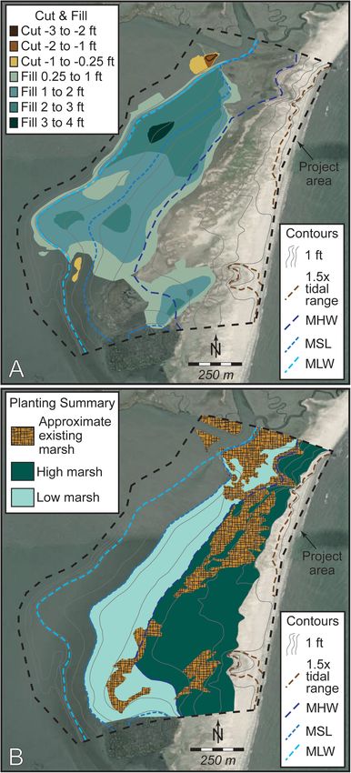
Hein et al.                                                                                                                          Cedar Island Marsh Creation Project

  FIGURE 1 | Conceptual model of barrier-saltmarsh couplings along a landward-migrating barrier island. (A) Marsh situated along the landward margins of barrier
  islands fills backbarrier accommodation, providing a platform upon which the barrier can perch, thereby slowing its migration and allowing sand that would have filled
  the adjacent lagoon through overwash to build the island vertically. (B) Backbarrier marsh reduces backbarrier tidal prism and widens the barrier-marsh system,
  reducing the likelihood of breaching and formation of ephemeral tidal inlets.

(3.5–5.0 mm yr−1 ; Boon and Mitchell, 2015), and sediment                               5 m yr−1 from the 1850s through 2010, accelerating to
supply (Shawler et al., 2021b). Twelve of these islands are                             11 m yr−1 between 1980 and 2010 (Deaton et al., 2017).
presently undeveloped, and have no history of soft (e.g., beach                         This has occurred predominantly through overwash, island
nourishment) or hard (e.g., seawalls, bulkheads, groins or                              breaching, and – to a lesser extent – aeolian transport through
jetties) shoreline stabilization projects. These islands and the                        the island’s segmented foredune ridge. In particular, Nebel
bays behind them serve as centers of commerce (aquaculture,                             et al. (2013) observed that the southern 4 km of Cedar
tourism) and recreation. They have also been focal areas for                            Island retreated by ∼25 m as a result of a single tropical
ecological restoration and research through partnerships between                        storm (Ernesto) in 2013. Repeated breaching along this same
academics, non-governmental organizations, and local and state                          island segment formed a series of ephemeral tidal inlets over
governments. The Nature Conservancy, which owns all or                                  the last 60 years (Hanley and McBride, 2011). While open,
parts of many of these islands, have protected ∼55,000 ha                               these inlets allowed for increased wave energy reaching the
(including >110 km of beachfront) of the islands and backbarrier                        backbarrier, contributing to the loss of approximately 1,000 ha
marshes, lagoons, creeks, and tidal flats. Combined efforts of                          of saltmarsh during the last 150 years (Nebel et al., 2013;
non-governmental organizations, academia, and government                                Deaton et al., 2017).
have led to the restoration of approximately 24 ha of oyster                                The youngest of these ephemeral tidal inlets, known locally
reef; designation of 810 ha of oyster reef as sanctuaries;                              as “The Breach,” first opened in 1993, closed for 6 months
establishment of 3,367 ha of eelgrass meadows (the largest                              in 1997, and then reopened, migrated south, rotated counter-
seagrass restoration project in the world; Orth et al., 2020); and                      clockwise, and closed in 2006 (Moyer, 2007; Hanley et al.,
the successful reintroduction of the bay scallop, a species that                        2015; Figure 3). This breach and attendant formation of
locally disappeared 80 years ago due to loss of seagrass habitat                        inlet shoals sequestered sediment moving in the southerly
(Oreska et al., 2017).                                                                  longshore transport system which, in turn, resulted in accelerated
    A mixture of federal and state agencies, non-governmental                           degradation, landward migration, and shortening of the southern
organizations, and private landowners own and manage Cedar                              end of the island (Figure 3). During this period, tidal flows
Island and nearby backbarrier marshes. Structures are limited                           were altered, and greater storm surges exacerbated mainland
to remnants of a US Coast Guard station active from the                                 flooding. Increased wave energy entering through The Breach
late 1800s to the mid-1900s near the northern end of the                                resulted in higher wave energy in the proximal backbarrier,
island. Along the southern 3 km of the island, several                                  further accelerating marsh-edge erosion. Conspicuously, The
private homes were present from the 1980s to 2010s, but                                 Breach formed at a location where no marsh existed (and
all have been destroyed by storms or preemptively removed                               still does not exist) directly behind the island, a configuration
by homeowners because of erosion threats. Cedar Island is                               reflecting greater lagoonal accommodation resulting from deeper
among the most dynamic of the Delmarva Peninsula barrier                                antecedent substrate (Shawler et al., 2021a) and/or erosion
islands: following a period of progradation along its northern                          by earlier ephemeral tidal inlets in this location (Hanley and
end prior to ca. 1850 (Shawler et al., 2019), Cedar Island has                          McBride, 2011). This area remains a likely location for a
undergone landward migration at an island-averaged rate of                              future breach.

Frontiers in Marine Science | www.frontiersin.org                                   3                                        September 2021 | Volume 8 | Article 721904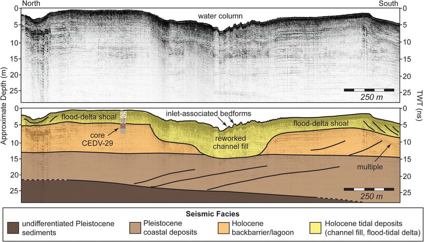
Hein et al. Cedar Island Marsh Creation Project
This process has accelerated marsh-edge erosion and realignment
and partial shoaling of adjacent navigation channels.
METHODS: FIELD DATA COLLECTION
AND ANALYSIS
A combination of morphologic, stratigraphic, sedimentologic,
and ecologic field data collection (Figure 4) allowed for detailed
mapping of the marsh construction and restoration project
site, quantification of ecologic and sedimentologic success
targets, and identification of potential borrow sites. These
data were then integrated and used to inform details of an
engineering design plan and quantification of sediment needs and
potential sources.
In order to produce a baseline map for use in design
planning, we developed a seamless topographic-bathymetric
(topo-bathy) map from existing and new field data. Existing
topo-bathy data were compiled from a 2010 Eastern Shore
digital elevation model (DEM) [OCM (National Oceanic and
Atmospheric Administration Office for Coastal Management)
Partners, 2020b], a 2016 US Army Corps of Engineers
post-Matthew LiDAR survey [OCM (National Oceanic and
Atmospheric Administration Office for Coastal Management)
Partners, 2020a], a 2016 US Geological Survey Coastal National
Elevation Database Topobathymetric Digital Elevation Model
(CoNED TBDEM) [OCM (National Oceanic and Atmospheric
Administration Office for Coastal Management) Partners, 2020c],
and National Oceanic and Atmospheric Administration tidal
datum data from at Wachapreague, VA (Station 8631044).
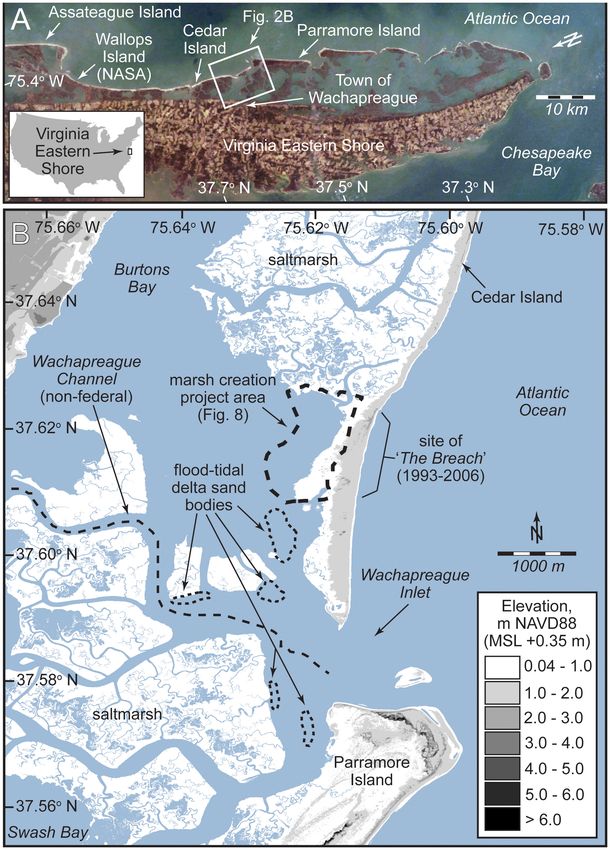
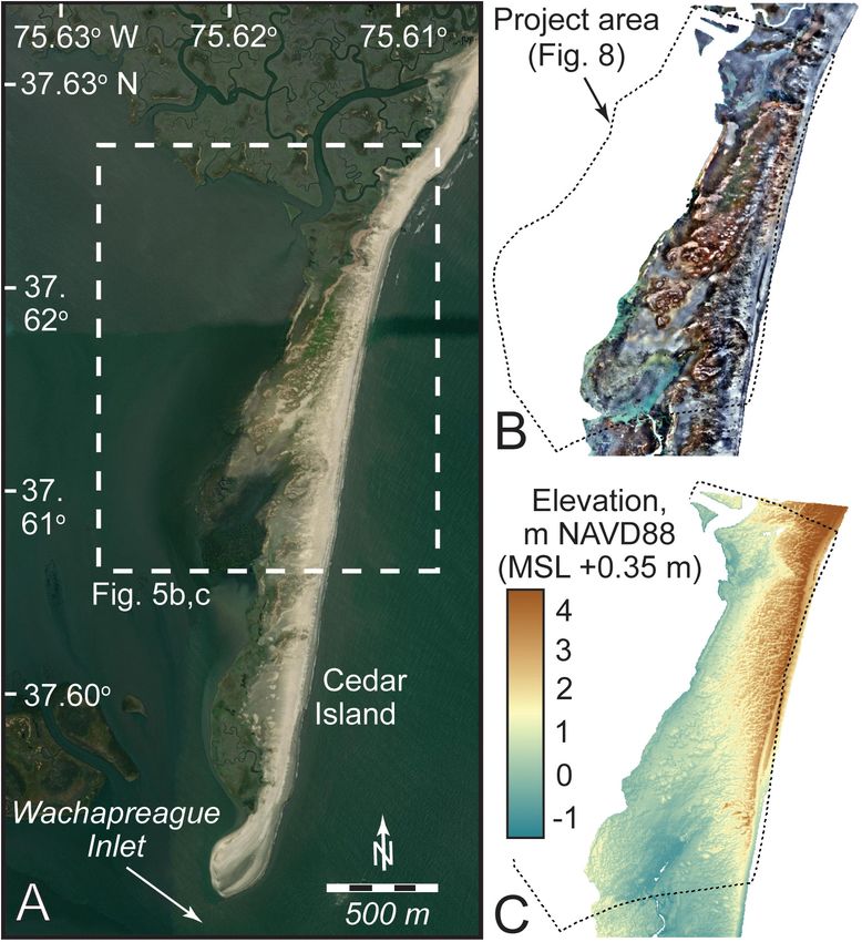
FIGURE 2 | Project study site. (A) The Virginia Eastern Shore and its barrier
islands. Modified from Deaton et al. (2017). (B) Southern Cedar Island and New subaerial topographic and shallow bathymetric data were
vicinity, showing key features, channels, flood-tidal delta shoals, and the collected along southern Cedar Island and its backbarrier
marsh creation project area. Digital elevation model is from topographic and (Figure 5A) through use of high-resolution aerial imagery
shallow bathymetric lidar [OCM (National Oceanic and Atmospheric obtained in November of 2019 using unmanned aerial vehicles
Administration Office for Coastal Management) Partners, 2020c].
(drones). Imagery was collected with a SenseFly eBee drone with a
global-positioning system with real-time kinematics (RTK-GPS),
which yields centimeter-resolution (error: ∼3 cm horizontal,
Today, the southern ∼4 km of Cedar Island is offset farther ∼5 cm vertical) GPS tags on each image. Survey missions were
landward from the northern end of the island by nearly 500 m flown at 100 m above mean sea level, with 75% latitudinal and
(Figures 2B, 3). This condition likely reflects, in part, the longitudinal overlap, yielding a ground resolution of 2.5 cm/pixel.
presence of an extensive and largely contiguous marsh platform Following Roze et al. (2014), we estimate a vertical uncertainty for
in the backbarrier directly behind the northern 8 km of the individual DEM pixels of 1–3 times the ground sampling distance
island, which widens the island system, thereby limiting inlet (2.5–7.5 cm in this case). Images were collected with ground-
formation. Additionally, migration atop this marsh has provided control points deployed on the beach as well, in case of RTK-GPS
this portion of the island with a natural perch, allowing sediment correction loss during flight. Images were analyzed using Agisoft
delivered to the beach and dunes to accumulate vertically, slowing Metashape photogrammetry software to produce orthomosaics
its landward migration (Walters et al., 2014; Deaton et al., 2017). (Figure 5B), DEMs (Figure 5C), three-dimensional models,
In contrast, the southern end of the island contains only fringing and dense point clouds. Topographic and shallow bathymetric
backbarrier saltmarsh, washover fans, and shallow subaqueous data were merged and used to: (1) develop seamless, updated
bars associated with relict flood-tidal deltas deposited by former topographic-bathymetric contours; (2) define and delineate
ephemeral inlets (Figure 2B). During the last decade, widening existing high and low marsh areas as well as targeted post-project
of Wachapreague Inlet has resulted in additional erosion of high and low marsh areas; and (3) compute fill height and final
the southern 25 ha of the island (Figure 3). Combined, these bottom elevations at each coordinate in the targeted project site.
processes have led to rapid thinning, degradation, and landward Surface morphologic mapping data were supplemented
migration of the island’s southern 4 km. Additionally, the with >30 km of shallow seismic data (Figure 4A), collected
widening of Wachapreague Inlet has led to increased backbarrier using an Applied Acoustics AA300 boomer seismic system
wave energy from greater exposure to open-ocean conditions. operated at 150–300 J, with a CSP300 seismic energy source
Frontiers in Marine Science | www.frontiersin.org 4 September 2021 | Volume 8 | Article 721904
Hein et al.                                                                                                                        Cedar Island Marsh Creation Project

  FIGURE 3 | Historic satellite orthoimagery from southern Cedar Island, showing physical change over a period of 33 years (1985–2018). Note the combination of
  former island breaching (1993–2006) and more recent shortening due to widening of Wachapreague Inlet (2011–2018). The marsh restoration site is located
  landward of the former inlet (locally called “The Breach”). Imagery sources: Landsat (1985, 2000), US Geological Survey (1994), the Commonwealth of Virginia (2007)
  and the National Agriculture Imagery Program of the US Department of Agriculture’s Farm Service Agency (2011, 2018). Historical shorelines overlain on 1985 image
  are from historical maps and NOAA t-sheets, digitized by Himmelstoss et al. (2010).

and 4.5 m long Applied Acoustics hydrophone streamer with                             between the vessel and seafloor allowed for high-precision
eight elements. A Trimble DSM 132 differential GPS marine                             mapping of bathymetry along seismic tracklines.
positioning receiver and antenna enabled merging real-time                               Geophysical data were ground-truthed with 121 bottom grab
digital geographic positions to digital SEG-Y seismic data. This                      samples collected with a ponar grab sampler, 57 shallow-auger
system provided submeter horizontal positional accuracy and                           (15 cm depth) beach sediment samples, 11 vibracores (4.5–
up to 60 m of penetration based on an assumed sound velocity                          5.0 m long, 7.6 cm in diameter), and two direct-push cores
of 1,500 m/s. This depth penetration allowed for medium-                              collected with a Geoprobe 66DT coring rig (17 and 24.5 m long;
resolution (1–2 m) imaging of major lithological units, and                           5 cm in diameter) (Figure 4). Of these, data from seven cores
determination of sediment thickness and potential borrow                              were published previously by Shawler et al. (2019) and Shawler
sediment deposits under the project area (Figure 6), and                              et al. (2021a); all other data are new to this study. Sediment
associated sediment volumes through multiple crossing lines.                          cores were opened, photographed, described for texture (as
Chesapeake Technologies’ SonarWiz software version 7 was                              compared to standards), mineralogy, and color (using a Munsell
used for data acquisition, processing, and interpretation. Tide-                      Soil Color Chart), interpreted for graphic core logs (Figure 7)
corrected analysis of two-way-travel time of the seismic signal                       and sampled for grain size. Aliquots of all surface, shallow

Frontiers in Marine Science | www.frontiersin.org                                 5                                       September 2021 | Volume 8 | Article 721904
Hein et al.                                                                                                                         Cedar Island Marsh Creation Project

  FIGURE 4 | Map of southern Cedar Island and vicinity showing locations of field mapping and data collection. (A) Locations of ∼30 km of shallow-seismic profiles
  (black lines) overlain on digital elevation model (topographic and shallow bathymetric lidar; OCM (National Oceanic and Atmospheric Administration Office for Coastal
  Management) Partners, 2020c). (B) Sedimentologic and ecologic data collection. The former consists of 121 bottom grab samples, 57 shallow-auger beach
  sediment samples, 11 vibracores (labeled “CEDV-xx”), and two direct-push Geoprobe cores (labeled “CEDG-xx”). Ecological data were collected along six transects,
  with two each in reference marshes (labeled “Ref1” and “Ref2”), prospective project area marshes (labeled “Tar1” and “Tar2”), and a representative borrow site
  (labeled “Bor1” and “Bor2”). Background image is December 2018 orthophoto from the National Agriculture Imagery Program, administered by the US Department
  of Agriculture’s Farm Service Agency. Note difference in morphology of southern-most Cedar Island between images (approximately 2 years).

auger, and core sediment samples were dried and analyzed                               feasibility (based on estimated cost and needed fill material
for organic content (loss-on-ignition) through combustion at                           for construction) and expected benefits in terms of enhanced
650◦ C for ∼14 h and for calcium carbonate content through                             barrier-marsh system resiliency. Design concepts and the design-
treatment with 10 M HCl. Grain-size analysis was conducted                             selection process – which considered factors such as stakeholder
on wet sample aliquots using a Beckman Coulter LS 13320                                needs, cost, and permitting in addition to best-available
(Beckman Coulter GmbH, Krefeld, Germany) laser diffraction                             science – are detailed in section “Science-Based Concept Design
particle size analyzer, equipped with an aqueous liquid module                         Development for Habitat Restoration and Coastal Resilience.”
and a Polarization Intensity Differential Scatter unit. Grain-size                     Here, we present results of our field data collection and analysis,
distributions were calculated using the Fraunhofer optical model                       and detail resulting preliminary plans for our chosen design
(see de Boer et al., 1987).                                                            (Concept 2) and proposed sediment borrow sites.
    Finally, we collected a suite of marsh-site characteristic data
in order to ensure created marsh within the target project                             Preliminary Design Plans
area is compatible with local marsh types and characteristics.                         Developed design plans are for a marsh construction project
Specifically, we surveyed six transects (two each at construction,                     within a 160-ha area that is approximately 1,800 m long (north-
reference, and borrow site types; each 170–470 m long,                                 south) and 630–1,150 m wide (east-west). Located ∼2 km north
Figure 4B) for ecological variables of plant species composition                       of Wachapreague Inlet, the project area would extend from
and percent cover and benthic macrofaunal densities. Transects                         the southern margin of the broad (3 km wide) marsh backing
ran from MLLW to MHW tidal datums. Access was restricted                               northern Cedar, across a shallow lagoon, and to south of the
in areas of higher elevation close to dunes to protect nesting                         former flood-tidal delta of The Breach (Figure 8). This is an
shorebirds. Transect surveys consisted of a 1×1 m quadrat every                        area characterized by low-profile (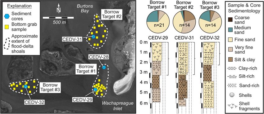
Hein et al.                                                                                                                    Cedar Island Marsh Creation Project

  FIGURE 5 | Results of drone-based topographic-bathymetric mapping of the southern Cedar Island project area. (A) Satellite image of southern Cedar Island
  (December 2018; from National Agriculture Imagery Program, administered by the US Department of Agriculture’s Farm Service Agency). (B) Orthoimagery data
  collected and mosaicked through structure-from-motion technology, converted into (C) a digital elevation model. Data collected November 2019 and processed by
  K. McPherran, University of Delaware.

sand (median grain size: ∼0.21–0.29 mm) and become finer                            sampled ∼3.5 m of sandy clayey silt (shallow lagoon sediment)
grained (muddy very fine to fine sand; median grain size:                           overtopping organic-rich, laminated silty-clay (deep, quiet-water
∼0.09–0.14 mm) to the north and south. The finest sediments                         lagoon deposits) and capped by mica-rich alternating layers of
(largely sandy silt; median grain size: ∼20–60 µm) are found                        sandy silt and silty very fine to fine sand (likely wind-transported
at the northern end of the project area, adjacent to the marsh,                     barrier beach and dune deposits). The stratigraphic successions
outside of the influence of the former tidal inlet.                                 captured in these sediment cores from within the project area
   A sediment core (CEDV-20) collected through the former                           contrast with that of core CEDV-19, collected through barrier-
location of the flood-tidal delta of The Breach revealed that inlet-                adjacent saltmarsh at the northern boundary of our project
associated deposits are nearly 3–4 m thick (Figure 7B). These                       area (Figure 7B). Here, fine, mica- and heavy-mineral-rich
are characterized by alternating very fine sand and sandy silt                      sand is overlain by 5.5 m of interbedded clayey silt and clean,
layers near the base; overtopped by 2 m of fine to medium,                          fine quartz sand, and capped by ∼1 m of saltmarsh peat.
well-sorted and subrounded, mica- and heavy-mineral-rich sand                       This facies succession is interpreted at the “natural” regressive-
with abundant shell hash and some rock fragments; and capped                        transgressive stratigraphy of Cedar Island (Shawler et al., 2019,
by interbedded sandy silt and silty very fine to fine sand. We                      2021a). Consequently, our marsh construction project aims to
interpret the latter to be barrier-proximal lagoon incorporating                    replicate the gross characteristics of the upper sections of this
overwash and aeolian-transported beach and dune sand; flood-                        vertical sequence.
tidal delta and inlet channel fill deposits; and shallow sub-                          This project will build 46 and 42 ha of high and low marsh,
tidal to intertidal barrier-proximal lagoon facies, respectively.                   respectively, supplementing the existing 21 ha of saltmarsh that
North of the former flood-tidal delta, CEDV-27 (Figure 7B)                          has built naturally upon flood-tidal delta and inlet-fill deposits

Frontiers in Marine Science | www.frontiersin.org                               7                                      September 2021 | Volume 8 | Article 721904
Hein et al.                                                                                                                       Cedar Island Marsh Creation Project

  FIGURE 6 | Example of processed (top) and interpreted (bottom) seismic data from Cedar Island backbarrier. Seismic profile line was collected along a north-south
  transect along the west side of a flood channel extending from Wachapreague Inlet (see location, Figure 4). Profile crosses over the location of sediment core
  CEDV-29 (core log shown on profile; for detail see Figures 7, 10), collected through target sand borrow site #1 (Figure 10).

associated with the former Breach. The proposed Grading Plan                          result from overwash events and location with respect to tidal
(sediment cut and fill) (Figure 8A) requires: (1) extending the                       creeks. Following these characteristics, design plans include
fill area out to −5 ft NAVD88 (−1.98 m MHW) contour; (2)                              planting of low marsh with Spartina alterniflora between mean
achieving a maximum fill thickness of 2 ft (0.61 m) at the −2 ft                      sea level and mean high water. Designs also include planting of
NAVD88 (−1.06 m MHW) contour; and (3) tapering the fill both                          high marsh with Spartina patens between mean high water and
shallower and deeper than −2 ft NAVD88 (−1.06 m MHW) so                               4.5 ft NAVD88 (0.9 m MHW), which is typical of the area (Tolley
that the fill ties into existing contours. High marsh regions will                    and Christian, 1999; Lonard et al., 2010) but was precluded from
be graded at a lagoon-ward (westward) slope of 1:750 and low                          our field survey. Planted areas will be defined by the elevation
marsh at a slope of 1:330 to 1:390. The low marsh will be stepped                     of graded sediment, after the sediment has had sufficient time to
into the lagoon at a steeper grade of 1:50 to 1:70. These shallow                     dewater and settle, and the planted area will greatly exceed the
slopes were selected to maximize the width of the final marsh.                        area of the marsh disturbed by grading. Plants will be sourced as
During and immediately following placement, the channel-ward                          plugs and spaced ∼45 cm00 apart, planted using a power auger
margin of the sediment fill may require stabilization (e.g., coir                     to drill holes, with manual plug placement. Plantings will be
logs or similar) and avian exclusion strategies (e.g., goose fencing)                 monitored during each growing season for a minimum of 3 years
until planted vegetation is established.                                              (and likely longer) and replanted as necessary to satisfy typical
    The marshes at and around the project site display typical                        permit conditions, though scientific monitoring is expected to
faunal and floral assemblages of Mid-Atlantic back-barrier                            continue in perpetuity as part of on-going monitoring projects on
marshes (Tyler and Zieman, 1999; Walsh, 1998), containing                             the island, in part as a macrocosm test of marsh-barrier couplings.
50–90% vegetation cover of Spartina alterniflora and few other
vascular plant species and common marsh invertebrates of fiddler
crabs Uca spp., ribbed mussels Geukensia demissa, mud snails                          Proposed Borrow Sites
Tritia obsoleta, and periwinkle snails Littoraria irrorata. The                       The project scope requires a net 285,603 m3 (5,119 m3 cut;
northern reference and project area transects (Ref1 and Tar1;                         290,722 m3 fill) of source material as fill to elevate and grade
see locations in Figure 4B) are similar to the southern reference                     backbarrier reaches and establish new high and low marsh along
and project area transects (Ref2 and Tar2) (Figure 9). Northern                       southern Cedar Island. In general, marshes range from fine-
transects (Ref1 and Tar1) had greater densities of fiddler crabs                      (clay) to coarse- (sand) grained sediments due to the biological
whereas southern transects (Ref2 and Tar2) had greater and                            trapping and tidal/storm processes. The first fundamental step
more variable densities of mud snails (Figure 9). The highest                         toward restoration and new marsh creation is to (re-)establish
density of ribbed mussels occurred at the northernmost transect                       saltmarsh structure and function, which includes stability of
(Ref1), whereas the highest density of periwinkle snails was at                       marsh sediments. To accomplish this, the grain size of the
the southernmost transect (Tar2). Differences in the invertebrate                     fill material is the dominant characteristic considered when
community likely reflect substrate grain size differences that                        designing a saltmarsh system. This must be consistent with the

Frontiers in Marine Science | www.frontiersin.org                                 8                                       September 2021 | Volume 8 | Article 721904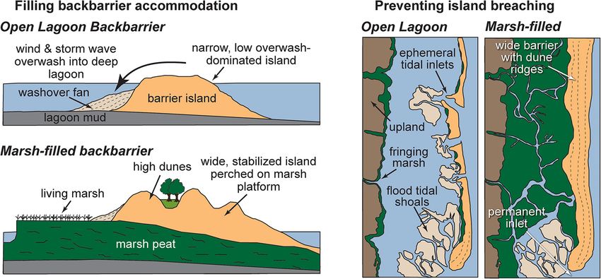
Hein et al. Cedar Island Marsh Creation Project
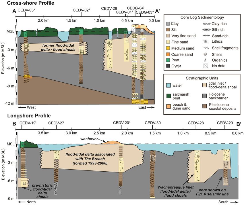
FIGURE 7 | Stratigraphic sections developed from cores collected along (A) shore-normal and (B) shore-parallel transects west (landward) of southern Cedar Island
(see location, Figure 4). Cores targeted the project site (CEDV-20, CEDV-27), flood-delta shoals (target borrow sites) (CEDV-28, CEDV-29), and reference island
(CEDG-03, CEDG-04) and saltmarsh (e.g., CEDV-19, CEDV-02) locations. Core logs denoted with an asterisk (*) were originally published by Shawler et al. (2019);
those denoted with a dagger (†) were originally published by Shawler et al. (2021a).
existing sediment currently found in the backbarrier marshes Donaldson, 1973). To the east (seaward) of this channel is a
of southern Cedar Island. Therefore, we target predominantly crescent-shaped ebb-tidal delta that is one of the largest along
silty sand – matching those proximal backbarrier sediments the Delmarva Peninsula; landward of the channel is a disparate,
unaffiliated with the former Breach flood-tidal delta (Figure 7B) – atypically shaped flood-tidal delta (Richardson et al., 2015).
for use as fill material to provide stability and biological function Sand bodies associated with this latter feature extend more than
necessary for restoration. Candidates for this source material 1.5 km landward of the main ebb channel of Wachapreague
include: (1) shoals associated with the Wachapreague Inlet Inlet. Seismic data, ground-truthed with sediment cores, reveal
flood-tidal delta; and (2) dredge spoil from nearby backbarrier that flood-tidal delta shoals consist of short, discontinuous, and
navigation channels. chaotic reflectors indicative of reworked material and overlie
Located at the southern terminus of Cedar Island, uniform-amplitude, continuous reflectors characteristic of
Wachapreague Inlet is the primary conduit for exchanging finer-grained muds deposited in a lower-energy environment.
∼55 × 106 m3 of water between the Atlantic Ocean and Multiple high-amplitude reflectors are indicative of major
backbarrier bays during each tidal cycle (Fenster et al., 2011). erosion surfaces at the lower boundaries of these flood-tidal delta
The inlet is characterized by a single, stable, deep (∼20 m) sands. Sand bodies are commonly found along the margins of
channel, anchored in a Pleistocene stream valley (Morton and major inlet-proximal tidal channels (Figure 2B) and are 2–3 m
Frontiers in Marine Science | www.frontiersin.org 9 September 2021 | Volume 8 | Article 721904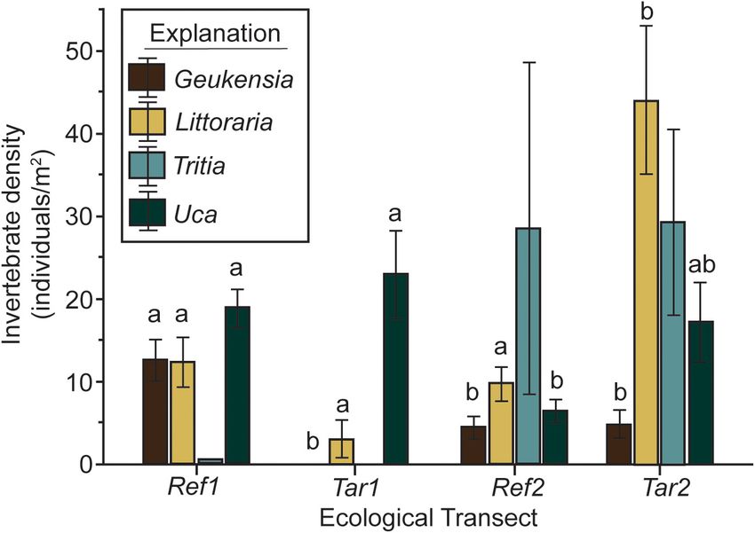
Hein et al.                                                                                                                      Cedar Island Marsh Creation Project

TABLE 1 | Comparison of preliminary design concepts considered for full design.

Design          Description                               Map of approximate            Created low        Created high        Total marsh area    Fill volume (m3 )
concept                                                      project area              marsh area (ha)    marsh area (ha)             (ha)

Concept 1       creation of 0.5–1.0 km wide marsh                                            69                  60                      129           382,277
                platform along southern ∼4.0 km of
                Cedar Island

Concept 2       creation of 0.5–1.0 km wide marsh                                            42                  46                      88            285,603
                platform along ∼1.5 km length of Cedar
                Island, at site of former Breach

Concept 3       creation of ∼0.5 km wide marsh                                                5                  22                      27             22,937
                platform along inlet-adjacent ∼0.75 km
                of Cedar Island

Concept 4       creation of 0.8–1.3 km wide marsh                                            30                  22                      52            168,202
                platform along inlet-adjacent ∼0.75 km
                of Cedar Island, combined with inlet
                flood channel re-orientation to expand
                project area to west

Concept 5       creation of 0.5–1.0 km wide marsh                                            69                  60                      129           382,277
                platform along southern ∼4.0 km of
                southern Cedar Island, combined with
                beach nourishment and dune
                construction

Concept 2 was chosen based on best-available science, considering cost and effectiveness, and following input from local stakeholders.

thick, on average (Figure 10). These sand bodies are depauperate                       likely sources. Wachapreague Harbor and Inlet are connected
and predominantly occupied by Agarophyton vermiculophyllum                             by the federal Bradford Bay and Finney Creek channels, as
(previously Gracilaria vermiculophylla)-Diopatra cuprea                                well as the non-federal Wachapreague Channel (Figure 2B).
polychaete associations (Thomsen et al., 2009). Besterman                              Dredging of the federal channels is conducted by the US Army
et al. (2020) have studied the value of this association in terms of                   Corps of Engineers approximately once every 7 years under the
biological resources for shorebirds, a major conservation concern                      auspices of the US Water Resources Development Act of 1992,
for the region. The association is common in the Virginia coastal                      Continuing Authorities Program Section 204 (Beneficial Uses of
lagoons and provides prey resources to generalist shorebirds, but                      Dredged Material). Dredging of the Bradford Bay and Finney
lower value resource quality for specialist foragers (Besterman                        Creek channels in summer 2020 yielded 94,014 m3 of sediment;
et al., 2020). These data and analyses allowed us to identify                          no textural data are currently available [USACE (US Army Corps
three flood-tidal delta bodies located nearby to our project                           of Engineers), 2021]. One possible impediment to using as a
site that may be used as potential borrow sites (at locations of                       source for our project sediments dredged in the future from
cores CEDV-29, −31, and −32; Figure 10). Together these total                          these channels – even if of suitable texture for use as marsh
∼790,000 m3 of sediment. Samples and cores reveal that these                           construction fill – is that transporting dredge spoils a minimum
deposits are composed of 85–98% (predominantly fine) sand,                             of 4.5 km from the dredge site to the marsh re-creation project
with median grain sizes ranging from 0.1 to 0.25 mm (Figure 10),                       area may require booster pumps and therefore would be a higher-
matching sand found within washover and former flood-tidal                             cost option. Further, use of the federal spoil is constricted by the
delta deposits at the project site (Figure 7).                                         timeline of federal dredging.
    Dredge spoil from lagoonal navigation channels may provide                            Hydrographic surveys are planned for summer 2021 for the
additional sources of sediment to the project. In particular,                          6.5-km long, non-federal Wachapreague Channel to determine
the maintenance of channels leading from the mainland                                  dredge volume required to restore the channel to a width of
Wachapreague Harbor, which is home to a US Coast Guard                                 at least 18.3 m and depth of 1.83 m. This channel is identified
station, tourism and aquatic-resource industries, and a scientific                     by the Eastern Shore of Virginia Regional Navigable Waterways
field, to Wachapreague Inlet and the Atlantic Ocean, provide                           Committee as a top-five dredging priority for Accomack County,

Frontiers in Marine Science | www.frontiersin.org                                 10                                     September 2021 | Volume 8 | Article 721904
Hein et al. Cedar Island Marsh Creation Project
FIGURE 9 | Results of invertebrate surveys from each reference (Ref1, Ref2)
and project (Tar1, Tar2) marsh and tidal flat ecologic transects (see location:
Figure 4B). Letters above bars denote significantly different groups in Tukey’s
post hoc tests.
and hydrographic surveys of estimated sediment volumes;
these activities are currently underway, led by the Accomack-
Northampton Planning District Commission (A-NPDC).
DISCUSSION
Science-Based Concept Design
Development for Habitat Restoration and
Coastal Resilience
Small- (Konisky et al., 2006), large- (Weinstein et al., 2001),
and regional-scale (e.g., Chesapeake Bay Watershed Agreement,
2014) marsh-restoration programs have underscored the value
of using tidal marshes as coastal resiliency promotors. Common
approaches have included thin-layer deposition (e.g., Raposa
et al., 2020), tidal-flow restoration (e.g., Warren et al., 2002;
Konisky et al., 2006), wetland creation through beneficial use of
dredge spoil (e.g., Cornwell et al., 2020), and others (c.f., Roman
and Burdick, 2012; Herbert et al., 2015; Broome et al., 2019).
However, rarely, if ever, have these efforts involved a synergistic,
barrier-island systems approach that uses marsh/barrier-island
bio-geomorphodynamics to attenuate accelerating barrier-
FIGURE 8 | Project area map showing (A) cut and fill areas and proposed system changes. Here, we detail the selection process used to
grading of existing marsh; and (B) low and high marsh planting plan.
develop a science-based marsh creation/restoration project
Engineering design drawings use Imperial units as required for permit
application drawings. 1 ft = 0.3048 m. MHW, mean high water; MLW, mean concept designed to improve barrier-system resilience through
low water; MSL, mean sea level. marsh/barrier-island couplings. In particular, we highlight
transferrable lessons associated with balancing design factors
such as stakeholder needs, cost, and permitting, in addition to
best-available science.
Virginia. Here, dredging is hindered in part by the lack of Southern Cedar Island, Virginia was chosen for this test
dredge material disposal sites. Additionally, designing a beneficial design case because of its recent (60-year) history of breaching
placement site for dredged material poses a financial obstacle and overwashing, narrowing (erosion due to inlet widening),
these rural localities. This scenario presents an opportunity for a lowering, and landward migration (see section “Case Study:
collaborative effort for dredging and dredge disposal. However, Cedar Island, Virginia, United States”). Marsh creation and
this requires further analysis of channel sediment textures expansion in our project area will fill accommodation behind
Frontiers in Marine Science | www.frontiersin.org 11 September 2021 | Volume 8 | Article 721904Hein et al. Cedar Island Marsh Creation Project FIGURE 10 | Approximate extents and sedimentology of discrete flood-tidal delta shoals located along the margins of major inlet-proximal tidal channels, and identified as potential sand reservoir borrow sites for marsh construction project. Pie charts show average grain-size distributions of all samples collected within a given target borrow site (total number given as n value within chart). Brackets to the right of core logs indicate the thickness sediments appropriate for borrow for the marsh construction project. the most vulnerable southern barrier reaches and consequently, and associated ecosystem services and ecological functions, mimic the northern, more resilient natural reaches. The low such as fish, invertebrate, and avian habitat, and blue carbon topography of Cedar Island topography maximizes the potential storage (Erwin, 1996; Day et al., 2008; Mcleod et al., 2011; for sediment delivery to the constructed marsh through overwash Kirwan and Mudd, 2012). and aeolian activity – processes known to maintain or increase The approach presented here is founded on more than a marsh elevation in relation to the water level with accelerating decade of basic research into the interdependencies between sea-level rise (e.g., Rodriguez et al., 2013; Kirwan et al., 2016; barrier islands and adjacent backbarrier saltmarshes. Most Walters and Kirwan, 2016). We anticipate that the migration importantly, it relies on numerical modeling experiments of Cedar Island onto the platform provided by the eastern demonstrating that the presence of a backbarrier marsh may (barrier-abutting) margin of our newly created marsh project reduce the rate of island migration, reduce the likelihood of will initially help to retain barrier sand in the subaerial barrier- breaching, and help to stabilize the island naturally (Walters system compartment, reduce the rate of island migration, et al., 2014; Brenner et al., 2015; Lorenzo-Trueba and Mariotti, and consequently, stabilize the island. Later, we expect the 2017; Nienhuis et al., 2021). However, no large-scale test of western edge of the marsh will form and grow at a pace these couplings has been conducted to date; construction of a commensurate with island rollover and eventually, sand will project that could be monitored over years to decades to validate cover the entire construction project and begin to build on existing models is a motivating objective of our design approach. natural marsh. Further, widening the presently narrow island Yet, any such real-world resiliency design project must also system with a newly constructed fringing marsh at the site balance considerations beyond those which are informed only by of a former ephemeral tidal inlet – and subsequent island science. This was reflected in our five design concepts (Table 1), elevating through sand deposition on top of this platform – which varied in scope and impact (both at the project and will reduce the likelihood of future storm breaching. Increased potential borrow sites) and reflected different balances among wave and tidal energy reaching the marshes behind Cedar Island science, engineering, stakeholder needs, anticipated budget and during past phases of ephemeral inlet openings accelerated permitting constraints, and maximizing benefits of habitat marsh-edge erosion along the eastern-facing marshes near the provision and shoreline protection. inlet (Erwin et al., 2004); indeed, edge erosion by wind waves For example, the Concept 1 design incorporated one-and- is a primary cause of marsh losses throughout the Virginia a-half times the marsh area (129 ha) as our chosen design Barrier Islands (Fagherazzi et al., 2013; McLoughlin et al., (Concept 2), and thus would have provided a marsh platform for 2015; Sepanik and McBride, 2015; Deaton et al., 2017). Thus, future migration of the entire southern ∼4 km of Cedar Island. mitigating future island breaching at this site will protect existing Implementation of this design concept would seek to prevent proximal marshes. Finally, this approach of coupling nature- future inlet formation at the site of The Breach and present the based island stabilization with marsh creation is expected to most comprehensive macro-scale test of modeled marsh-island have the added resiliency benefits of expanding marsh habitat couplings. In contrast, Concept 5 (i.e., Concept 1 backbarrier Frontiers in Marine Science | www.frontiersin.org 12 September 2021 | Volume 8 | Article 721904
Hein et al.                                                                                                         Cedar Island Marsh Creation Project

marsh construction combined with dune construction and beach                   engaged both local stakeholders and regional, state, and federal
nourishment) provided the most ambitious design, because it                    regulators at various stages of the design processes. We began
optimized island stability potential with a comprehensive marsh-,              by discussing our intent and project concept at the start of the
beach-, and dune-restoration effort. A similar project developed               design process with key stakeholders and regulators and followed
by Stantec in 2006 along Prime Hook National Wildlife Refuge                   those discussions by project mid-point with engineering concept
(Delaware) provides an example of success for this design                      design updates. After completing the field work, we presented a
concept (Tabar, 2018). However, coupling marsh construction                    comparative analysis of our five design concepts to stakeholders
with additional soft island-stabilization techniques negates our               at a specially called meeting at a time and location convenient to
ability to quantify the efficacy of constructed/restored backbarrier           stakeholders. Based on stakeholder feedback from this meeting,
marshes specifically on slowing migration of Cedar Island, and                 we discounted the beach and dune restoration in Concept 5, in
to transfer findings from long-term monitoring efforts to other                part, because some stakeholders (e.g., The Nature Conservancy)
projects. This approach also requires both a backbarrier fill                  purposefully manage the southern Virginia Barrier Island beaches
volume for marsh creation equivalent to that of Concept 2, and                 and dunes to retain a natural, dynamic state.
additional sediment for creating and nourishing 4 km of dune                       Based on these considerations, our team concluded, in
and beach. These requirements could be difficult to satisfy in                 consultation with local and regional stakeholders and regulators,
sand-starved regions like the Virginia Barrier Islands and pose                that Concept 2 would provide the best balance between scope
budgetary constraints.                                                         (cost, fill material required, completion timeliness, mitigation
   Our final three conceptual designs reflected possible                       effectiveness, likelihood of permitting), and long-term resilience.
limitations associated with fill needs, cost, and permitting. Each             Numerical hydrodynamic/sediment-transport modeling of
of these incorporated components of the Concept 1 design:                      Wachapreague Inlet and vicinity – currently underway as part
Concept 2 (our chosen design) emphasized the dual role of the                  of final project design and permitting – will quantify changes in
created marsh in providing a platform for island migration and                 circulation and morphological characteristics between existing
minimizing the prospect of future inlet breaching, but left the                and proposed conditions and help identify potential design
southern 2 km of Cedar Island vulnerable to continued erosion.                 modifications based on the hydrodynamic changes. Similar to
Concept 3, requiring an order of magnitude less fill volume                    many backbarrier bays and lagoons, the target project region
(∼23,000 m3 ) to create a marsh area (27 ha) approximately                     is broad and shallow, limiting the required fill volume despite
one-third that of Concept 2, benefitted from proximity to                      the large project area. Additionally, the aerial extent of the
Borrow Target #1 (Figure 10), but would have created a marsh                   construction/restoration has been designed to account for both
only half as wide as the island in that area; this narrow marsh                public shellfish grounds and private leases, thus avoiding a
would leave less of a platform for island migration as some of                 substantial regulatory hurdle. Nonetheless, estimated projected
the other design concepts. To address this, Concept 4 (requiring               costs approach approximately US$10 million, presenting a
7× as much fill sediment as Concept 3) proposed reorienting                    financial hurdle to implementation. Finally, beneficial use of
a tidal channel located between southern Cedar and Borrow                      dredge spoil from backbarrier navigation channels provides
Target #1. This approach would allow for construction of a                     one of the most likely sediment sources for the 285,000 m3
marsh more than twice as wide as that designed for Concept                     of fill material required for the Concept 2 project because of
3, but would have to be built across an existing channel and                   existing dredging needs and cost effectiveness. However, use
much of Borrow Target #1. Unlike Concept 2, which would be                     of this material requires aligning project construction with the
largely built onto flood-tidal delta sands, the remaining Concept              timing, funding, and priorities for regional (state-supported) or
4 marsh (and the complete Concept 3 marsh) would be situated                   federal dredging.
on compactable mud (Figure 7), which may dewater and cause
more rapid subsidence. Concept 4 designs also extended marsh
onto the Borrow Target #1 flood shoal, removing this shoal                     Lessons on the Role of Stakeholder
as a potential sand source. Finally, historical shoreline-change               Engagement in Marsh Resilience Design
analyses showed that, while the marsh areas of Concepts 3 and                  Residents of Virginia’s Eastern Shore have been visiting,
4 would likely receive the largest volumes of sediment via the                 inhabiting, and using the adjacent barrier islands for farming,
adjacent Wachapreague Inlet (Castagno et al., 2018), further inlet             hunting, fishing, and ranching since the mid-1600s, following
widening (as is expected in a regime of accelerated sea-level rise             centuries of use and occasional habitation by the native
and/or increased storminess; Fenster et al., 2016) would threaten              Accomac and Occohannock peoples (Barnes and Truitt, 1997).
any created marsh along the southernmost 1 km of Cedar Island.                 Like many coastal communities, they share a wide-spread
   Beyond these scientific and engineering factors, stakeholder                recognition of the rapid changes occurring along this dynamic
needs, permitting considerations, and financial limitations of this            coast, and associated threats to the local environment, regional
rural locale all contributed to design decisions. For example,                 economy, and mainland physical infrastructure originating
constraints associated with funding and permitting rank among                  from habitat loss and the impacts of sea-level rise and
the most acute hurdles to coastal restoration and resiliency                   increased storminess (Chen et al., 2020). The underrepresented,
projects, especially in the face of regulatory inflexibility associated        economically depressed, sparsely populated rural communities
with permitting requirements of and processes within federal,                  of Virginia’s Eastern Shore find themselves at a disadvantage
state, and local agencies (Ulibarri et al., 2020). Our approach                in terms of competing for state and federal funding aimed at

Frontiers in Marine Science | www.frontiersin.org                         13                                 September 2021 | Volume 8 | Article 721904
Hein et al.                                                                                                     Cedar Island Marsh Creation Project

coastal resiliency efforts as compared to more populous localities            If successful, this design approach could be applied in other
(A-NPDC, 2015). The complex ownership of the Virginia Barrier              barrier settings in which unfilled backbarrier accommodation
Islands, and adjacent lagoons and marshes, by a network of public          has left the fronting island vulnerable to sand loss or breaching.
and private entities further complicates efforts at system-wide            Examples include Pea Island along North Carolina’s Outer Banks
resiliency management level (A-NPDC, 2015). Additionally, the              (Montoya et al., 2018); Tom’s Cove Isthmus along southern
authors have observed, for more than a decade, a perception of             Assateague Island, Virginia (Shawler et al., 2021b); southern
“savior science” that exists among local residents. This apparently        Long Beach Island, New Jersey (Rogers et al., 2015), multiple
emanates from an impression that science has overpromised on               vulnerable sites along Fire Island, New York (Hapke et al., 2013);
efforts to improve the resilience of the natural/physical system           and elsewhere along the Virginia Barrier Islands themselves (e.g.,
in which they live and work. According to local residents’                 southern Metompkin Island; Walters et al., 2014). A single federal
comments, this perceived failure has its origin in the inability of        agency or non-governmental organizations (i.e., National Park
experts to take into consideration local knowledge and desires             Service, US Fish and Wildlife Service, The Nature Conservancy)
or, at least, on the implications of those improvements for                own and manage each of these barriers; management, design, and
the livelihoods of residents. This perception has resulted in              permitting considerations are likely to be simplified as compared
skepticism of science-based solutions among subsets of the                 with Cedar Island.
local community, particularly those proposed by scientists from               The engineering design phase has allowed us to realize several
outside the community.                                                     transferable lessons related to design, funding, permitting, and
    In such cases, early partnership in the conceptualization,             stakeholder engagement:
design, and funding of a project of this nature is critical
to identifying the priorities of the local community and                     1) Final project design selection from a suite of coastal
achieving mutually desired outcomes with community support                      resiliency alternatives requires attentiveness to
(Adamowicz and O’Brien, 2012; Portnoy, 2012). Here, that                        multiple factors beyond scientific understanding of
process included conducting informational, feedback-gathering,                  complex physical and biological systems, including
and planning sessions at key times in project conception and                    (potentially complex) socio-economic, cultural, and
development; and communicating with the public through in-                      policy considerations.
person engagement and the media, aiming not to “oversell” the                2) Opportunities exist at the nexus of ecology, geology, and
project or its intended benefits for the local community. Future                engineering within the dynamic coastal zone. However,
efforts require continued two-way education focused on the                      successful implementation of cross-disciplinary projects
value of science-based decision-making that accounts for natural-               requires clear, regular, and timely communication; setting
system dynamics in concert with the interests of all involved to                aside of professional and disciplinary biases; and a
achieve resilience of a coupled natural and human system.                       willingness to trust the expertise of colleagues.
                                                                             3) Timely and regular engagement of regulatory agencies can
                                                                                guide project development and aid in project permitting.
SUMMARY AND RECOMMENDATIONS                                                  4) Complex ownership of lands within and adjacent to
                                                                                the project area requires early engagement with, and
This case study chronicles the data and process used to                         full buy-in from, diverse stakeholders, who may have
develop an interdisciplinary, science-based engineering                         competing interests.
design for mitigating barrier-island deterioration and                       5) Navigation channel maintenance and beneficial use of
enhancing ecosystem functions and coastal resiliency through                    dredged material provide opportunities for securing
backbarrier saltmarsh construction. The design is founded on                    fill material for large projects at low cost and minimal
a conceptual and evidence-based scientific understanding of                     environmental impact. However, the interaction of
interdependent barrier-marsh couplings and relies upon ecologic,                multiple, sometimes conflicting, interests and the
sedimentologic, stratigraphic, and morphologic field and lab                    uncertain and irregular timing of dredging operations can
data from the project site, adjacent reference saltmarshes, and                 hinder this strategy.
prospective sediment borrow sites. If constructed, the resulting             6) Regular, precise communication and early engagement
∼100 ha of existing and constructed marsh would fill backbarrier                with the general public can help set expectations of project
accommodation at the site of a former ephemeral inlet on Cedar                  outcomes and implications for local communities in terms
Island, Virginia. This effort would make southern Cedar Island                  of physical resilience, while also educating residents on
more resilient to future breaching and by providing a platform                  the economic, environmental, and community benefits of
upon which the island could migrate and aggrade. This approach                  ecological restoration.
to improved barrier-system resiliency is temporary: migration of             7) Local knowledge from stakeholders and community
undeveloped barrier islands is a long-term process that is likely               members can inform development of coastal management
to accelerate with sea-level rise (Mariotti, 2021). However, in the             projects on topics ranging from geography and bio-
short term (several decades), a project of this scope is likely to              physical changes to historic sites and economic
slow barrier migration and deterioration as compared with the                   considerations. Thus, engagement with stakeholders
“do nothing” alternative. This approach can provide a temporary                 needs to occur as a dialogue wherein the project team and
buffer for mainland communities and allow greater time to                       stakeholders learn from each other, and local information
increase resiliency to climate change and its coastal impacts.                  informs the final design. Doing so also builds trust.

Frontiers in Marine Science | www.frontiersin.org                     14                                 September 2021 | Volume 8 | Article 721904
You can also read