Report of the circumstances that led to the escapes of planned burns in the South West and Great Southern Regions of Western Australia on 24 and ...
←
→
Page content transcription
If your browser does not render page correctly, please read the page content below
Report of the circumstances that led to the escapes of
planned burns in the South West and Great Southern
Regions of Western Australia on 24 and 25 May 2018

           Prepared by the Office of Bushfire Risk Management

                          26 September 2018
Cover image. Post Stirling Range National Park bushfire (Kevin Haylock 2018)

Office of Bushfire Risk Management

Level 1 Albert Facey House

469 Wellington Street

PERTH WA 6000

obrm@dfes.wa.gov.au

Planned burning on remnant marri/jarrah forest on private land under mild autumn
conditions. (Kevin Haylock 2017)

Report of the escaped planned burns in the South West and Great Southern Regions in May 2018   Page 2 of 64
Contents
1          Executive Summary........................................................................................................ 5
2          Summary of Opportunities for Improvement................................................................ 9
3          Introduction ................................................................................................................. 12
4          Context of the Planned Burning Season ...................................................................... 14
    4.1 Climatic and Seasonal Conditions……….…………………………………………………………………. 14
    4.1.1 Historical ..................................................................................................................... 14
    4.1.2 The 2018 Autumn Season ........................................................................................... 15
    4.2      Fuel Load and Distribution ......................................................................................... 16
    4.3      Effect of Heavier Fuels on Fire Behaviour .................................................................. 18
    4.4      An Inevitable Reality – Fire is Here to Stay ................................................................ 19
    4.5      Restricted and Prohibited Burning Times .................................................................. 21
    4.6      Tenure and Risk Management Responsibilities………………………………………..………….. 22
    4.7      Community Profile and Fuel Management ................................................................ 23
5            Fire Events of 24 and 25 May and What Could Be Improved .................................... 26
    5.1      What happened……………………………………………………………………………………………..……. 26
    5.2      Weather Forecasts and Local Knowledge……………………………………………………………. 28
    5.3      Planned Burn Escapes………………………………………………………………………………………….. 30
    5.4      The Extent of Planned Burning…………………………………………………………………………….. 31
    5.5      Available Information and its Dissemination……………………………………………………….. 36
6            Appreciating and Responding to Risk ........................................................................ 40
    6.1      Community Appreciation of Risk………………………………………………………………………….. 40
    6.2      Risk at a Landscape Scale……………………………………………….………….………………………… 42
    6.3      Risk Management at an Organisational Level…………………….…………….………………….. 44
    6.4      Appreciating risk in developing burn plans…………………………………………………………… 46
    6.5      Appreciating risk prior to igniting planned burns…………………………………………………. 48
    6.6      Burn Security……..………………………………………………………………………………………………… 49
7            Desired Future State .................................................................................................. 51
8            References.................................................................................................................. 53
    Appendix 1. Terms of Reference and Review Particulars .................................................... 54
    Appendix 2. Independent Review of the Report ................................................................. 55
    Appendix 3. Acknowledgments ........................................................................................... 59

Report of the escaped planned burns in the South West and Great Southern Regions in May 2018                                   Page 3 of 64
Appendix 4. Bureau of Meteorology Report into the Meteorological Aspects of the Fires in
       the Stirling Ranges and near the South Coast of Western Australia May 2018 .......... 62
   Appendix 5. Department of Biodiversity, Conservation and Attractions Prescribed Burn
       Escapes Review – May 2018 ........................................................................................ 63
   Appendix 6. Glossary of Terms ............................................................................................ 64

Report of the escaped planned burns in the South West and Great Southern Regions in May 2018                       Page 4 of 64
1 Executive Summary
     There is no doubt that the bushfire related risk profile in Western Australia has and
     continues to change. There has been significant progress in the management of
     bushfire risk since the 2011 Margaret River bushfire however the dynamic nature of the
     interaction between the social, environmental, economic and cultural aspects creates
     complexity and requires contemporary and adaptive strategies to mitigate bushfire risk
     effectively.

     The application of traditional and cultural burning practices over millennia were
     responsible for the creation of a landscape of fire prone vegetation. The exclusion of
     fire from such a landscape is not possible and it is the ongoing use of both planned fire
     and its integration with alternative fuel reduction strategies that can achieve an
     acceptable balance of outcomes across the social, environmental, economic and
     cultural aspects. Understanding the context that is increasing the complexity of
     mitigating against large bushfires in Western Australia is an important first step to then
     developing strategies to effectively mitigate that risk.

     Climate in the South West Land Division (SWLD) of Western Australia is changing and
     this is challenging traditional land management practices. Bureau of Meteorology
     (BOM) data demonstrates a warming and drying climatic trend. This trend is causing
     seasonal variations such as longer drier periods into winter and warmer periods into
     spring. The warming and drying climate coupled with severe weather events are
     requiring land owners and managers to adapt their fire management strategies and
     better manage the risk of escape.

     The expansion and evolution of agricultural business and tourism in the SWLD has
     created a mosaic of land use and ownership across the landscape, increased permanent
     and transient (tourist and absentee) populations and created larger regional centres.
     This has increased the complexity of managing planned and unplanned fire in the
     landscape. Changing tenure and responsibility of land owners and managers in the
     SWLD and Western Australia more broadly, particularly in the context of native title
     determinations, is adding further complexity.

     All fires start small but big fires are harder to manage and put more firefighters and
     communities at risk of harm. Implementing strategic programs to reduce fuels loads
     and enable more effective management of bushfire fires is critical to minimise bushfire
     impact on the social, environmental, economic and cultural assets. The increasing
     complexity has challenged the achievement of strategic fuel reduction programs over
     recent decades and this has resulted in a relatively high fuel load across the SWLD. As
     fuel loads increase, the cost and scale of response to bushfires continues to increase as
     does the fires impact on the afore mentioned assets.

Report of the escaped planned burns in the South West and Great Southern Regions in May 2018   Page 5 of 64
In late May 2018, the first severe weather event for winter passed over the south-west
     of Western Australia. The weather event bought strong winds in excess of 120km/hr,
     highly variable rain and importantly a warm dry air mass ahead of the strong winds.
     Whilst a strong cold front is not unusual in May, the scale and significance of the event
     caught many land owners and managers by surprise and caused both the re-ignition
     and escape of some ‘dormant fires’ and the escape of still active fires in the SWLD on
     23, 24 and 25 May 2018. The Bureau of Meteorology (BOM) provided a report into the
     severe weather event, at Appendix 4. More than 150 fires were reported to the
     Department of Fire and Emergency Services (DFES) on 23, 24 and 25 May 2018. Several
     of these fires, namely the Chester Moonah, Torndirrup, Stirling Range, Peaceful Bay,
     Redmond and Napier bushfires were significant in scale and in some instances reported
     insurable losses and incurred considerable uninsurable losses. Due to the significance of
     some of the fires and their proximity to regional centres, government initiated a review
     into the circumstances that led to the planned burn escapes in order to identify
     opportunities for improvement.

     A key principle for risk management is continuous improvement. Government has
     committed to managing bushfire related risk to the communities of Western Australia
     and things that they value through continuous improvement. Whilst all local
     governments in the SWLD have drying and warming climatic trends, there was a high
     level of variability in the amount of planned burning across local governments prior to
     the severe weather event and the relative number of escapes. The review provided an
     excellent opportunity to understand what variations at an organisational and local
     government level exist that contributed to the escapes and their impacts and to also
     identify where successes existed and why. Seven local governments were subsequently
     selected for comparative purposes. These were the City of Albany and Shires of
     Denmark, Esperance, Harvey, Manjimup, Plantagenet and Ravensthorpe.

     This report is a concise summary of the understanding that the reviewers gained
     through their engagement with representatives from the seven local governments and
     their volunteers, members of the farming community in the Stirling Ranges, Esperance,
     Manjimup and Denmark, DFES, Department of Biodiversity, Conservation and
     Attractions – Parks and Wildlife Service (DBCA) and Forest Product Commission (FPC).
     Those that were interviewed were open, honest and enabled the reviewers to gain
     some valuable contexts that support the development of the opportunities for
     improvement contained within the report. DBCA also conducted a review into the
     Chester Moonah, Torndirrup and Stirling Range bushfires attached as Appendix 5.
     Consideration was given to their review in forming the opportunities for improvement
     (OFI) of this report.

     Governance of private property burning is becomingly increasingly important. Local
     governments have the primary role in governing and guiding the management of

Report of the escaped planned burns in the South West and Great Southern Regions in May 2018   Page 6 of 64
bushfire risk on private property. Whilst some local governments were wary of greater
     amounts of administration and restrictions on land owners and land managers it was
     acknowledged that an improved awareness of fire in the landscape at any given
     moment in time would be useful. The Shire of Harvey’s suggestion for a registration
     system (OFI 6) could support this improved knowledge. Its integration with existing
     public web-based platforms such as EmergencyWA could be beneficial for local
     governments, DFES, DBCA and the community.

     Communication failings leading up to the Stirling Range bushfire were highlighted in the
     review. The absence of effective communication with local volunteers and Senior Fire
     Control Officers meant local conditions were less well understood and resources to
     support the planned burn were limited. Revised organisational policies, procedures and
     practices to reduce bushfire risk, must be tailored to the needs of regions, organisations
     and activities incorporating local knowledge. A centralised, standard “one size fits all”
     approach should be avoided. The Shire’s of Manjimup and Esperance provided locally
     specific examples of how they effectively communicate and maintain situational
     awareness of fire in the landscape across organisations and volunteers. The
     promulgation of these approaches through a lessons sharing or management
     framework may be useful for other local governments (OFI 15). Equally so,
     enhancements to existing information sharing platforms and the type and availability of
     information is seen as a potential enhancement highlighted through OFI 6, 8, 9).

     The resourcing of planned burning activities was highlighted as a limiting factor in the
     success of planned burning outcomes and the lack of appropriate and adequate
     resources is a common element in planned burn escapes. Organisations such as DFES,
     DBCA and FPC are already arranging better support for their region’s planned burning
     activities and there are opportunities to better utilise existing resources at a local level
     (OFI 7).

     Skills and experience gaps limit the effectiveness of bushfire response and safe
     practices. Whilst not a new issue, a systematic process of locally based training,
     properly supervised practical experience incorporating better use of existing fire
     vehicles and equipment and aimed at increasing local capacity to undertake fuel load
     management is critical to achieving better bushfire mitigation outcomes. The creation
     of the DFES Bushfire Centre of Excellence will go a long way in addressing the training
     issues but there are some opportunities for improving the accessibility and availability
     of local resources (vehicles and people) to support planned burning activities. These
     opportunities have been highlighted in OFI 7b.

     The report acknowledges the efforts organisations are making to improve intelligence
     information, particularly DFES, and highlights an opportunity for improved consistency
     across organisations in the sharing of intelligence and weekly discussions regarding
     regional risk profiles. There has been an improvement in collaboration across the sector

Report of the escaped planned burns in the South West and Great Southern Regions in May 2018   Page 7 of 64
in recent years and this is facilitating continuous improvement. The review identified an
     opportunity for a rationalisation of varied forms of intelligence information/briefings
     and broader dissemination of some information for the benefit of emergency
     management staff within other organisations and local governments. These are
     highlighted in OFI 9 and 12.

     Acknowledging the increasing complexity and the imperative to protect Western
     Australian communities from bushfire has enabled organisations such as DFES, DBCA
     and local government to focus greater efforts on mitigating bushfire risk. It should be
     noted that many state government organisations use planned burning as a strategy to
     mitigate bushfire risk and protect assets. The bushfire reform measures announced in
     April 2018 by government and focuses on mitigation, the establishment of a Rural Fire
     Division (RFD) within DFES and creation of a Bushfire Centre of Excellence (BCoE)
     provides an opportunity to achieve improved bushfire risk management outcomes for
     Western Australia. The RFD will provide a coordinating role and development of risk
     mitigation strategies across the sector that incorporates strategic bushfire risk
     management and training. The creation of the RFD and with the BCoE will support
     collaboration across the sector by strengthening existing networks and creating new
     networks between state and local government, bushfire volunteers and Western
     Australian communities.

     In the spirit of continuous improvement, an independent review of the report contents
     and opportunities for improvement was conducted by Mr David Nugent, Chief Fire
     Officer, Parks Victoria. This has provided an external and independent perspective to
     the review and report. It also enabled an inter-jurisdictional perspective and opened
     the door for further discussions and professional networks to support Western
     Australia’s management of bushfire related risk. A copy of Mr Nugent’s review is
     attached at Appendix 2.

     The tracking of the implementation of the opportunities for improvement will be
     important to ensure integration of these with ‘business as usual’ going forward. The FES
     Commissioner will facilitate a review of the implementation of opportunities for
     improvement arising from this review after the twelve-month anniversary of the report
     release. The review of the progress on opportunities for improvement will coincide with
     the lead into the 2020 autumn planned burning season in the south of the State.

Report of the escaped planned burns in the South West and Great Southern Regions in May 2018   Page 8 of 64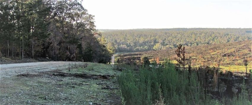
2 Summary of Opportunities for Improvement
     Opportunity for Improvement 1 (page 17)
     DFES through its leadership role on the State Bushfire Advisory Council (SBAC) develop
     a strategy to support the reduction of fuel on land neighbouring government owned
     and/or managed land that is limiting the management of bushfire related risk on that
     government land. (Terms of Reference E).

     Opportunity for Improvement 2 (page 18)
     Forest Industry Federation Western Australia, in collaboration with DFES and FPC
     review the Code of Forest Practice for Timber Plantations in Western Australia to
     incorporate a contemporary approach to the management of bushfire risk including
     clear guidelines on residue windrow dimensions. The implementation of new elements
     need to be integrated into staff development and plantation management strategies.
     (ToR - C)

     Opportunity for Improvement 3 (page 24)

     a) WALGA and local governments through consultation with DFES, develop physical and
        financial arrangements that can assist landowners to reduce the heavy fuels on
        private land, particularly on the rural-urban interface. (ToR - E)
     b) Local governments with support from DFES, conduct tailored and targeted
        information campaigns that change the behaviour of bushfire vulnerable
        communities. (ToR - A)

     Opportunity for Improvement 4 (page 25)
     WALGA, with project support from DFES develop an online system so that each local
     government can create a contemporary Section 33 Notice to reflect the integrated
     elements and local contexts for managing bushfire risk that can be hosted on the
     WALGA subscription service for local governments. (ToR - C and E)

     Opportunity for Improvement 5 (page 30)
     Local governments, through their Local Emergency Management Committees and in
     collaboration with DFES develop pre-season scenario-based exercises to test and
     practice emergency management arrangements to support learnings and development
     of effective strategies to prepare for fire weather events. (ToR - C and E)

     Opportunity for Improvement 6 (page 31)
     WALGA, in collaboration with DFES, develop a web-based, spatially enabled system of
     registering intention to ignite so that local governments can record a minimum amount

Report of the escaped planned burns in the South West and Great Southern Regions in May 2018   Page 9 of 64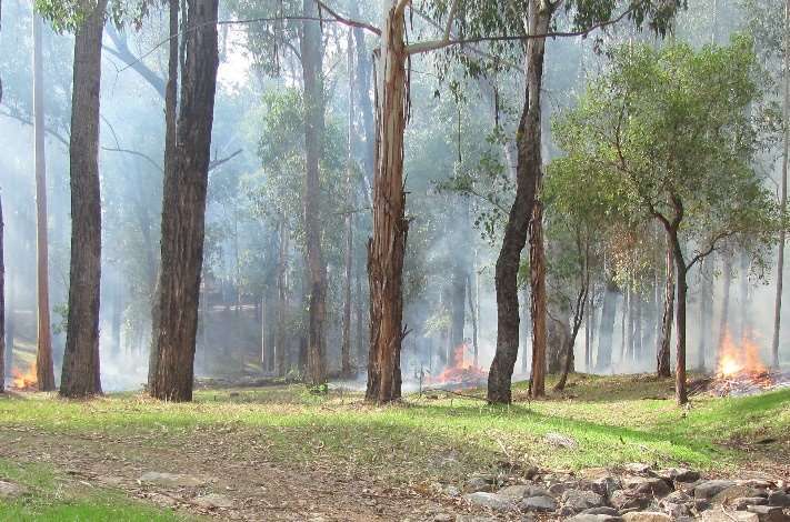
of information on burns being conducted on private land. This information could then
     be displayed on EmergencyWA.
     Additionally, DFES, through consultation with DBCA and WALGA explore opportunities
     to utilise additional features available through EmergencyWA to map planned burns
     links to important situational awareness information and provide notification to
     registered users. (ToR - A, C, D and E)

     Opportunity for Improvement 7 (page 35)
    a) DFES, WALGA and DBCA through consultation with local government, Volunteer
        Bush Fire Brigades, Volunteer Fire and Emergency Services and Volunteer Fire and
        Rescue Service brigades to develop arrangements that will enable organisations to
        utilise existing local government equipment for planned burning activities, increasing
        capacity at a local level to implement bushfire risk treatments. (ToR - C and E)
    b) DFES, through its RFD ensure its training programs for planned burning are
        supported by resourcing models that increase local participation. (ToR - C)
    c) DFES, in collaboration with local governments, explore strategies that could engage
        interested and available people such as part-time workers, fly-in, fly-out workers or
        the unemployed in planned burn training and operations to increase capacity, build
        capability and certainty of bushfire risk treatment works scheduling. (ToR - C and E)
     d) DBCA assess resource distribution and access to resourcing to provide greater
        support to the Great Southern Region for planned burning activities. (ToR - E)
     e) DFES, DBCA and WALGA develop flexible resourcing options that can provide both
        state government organisations and local governments support when required to
        plan and undertake planned burning operations. (ToR - C and E)

     Opportunity for Improvement 8 (page 37)
     DFES, through the RFD works with government organisations and local governments to
     provide access to tools and information that can support situational awareness and
     decisions to burn or not burn. (ToR - A and E)

     Opportunity for Improvement 9 (page 38)
     DFES, DBCA through consultation with local government and other state government
     organisations review the number, format and form of the reports and briefings
     provided internally and externally for their relevance and usefulness.
     The review should develop a product that is publicly available to support other
     organisations and private industries understand the current and forecast conditions
     that would influence fire behaviour and their operational activities. (ToR - A)

Report of the escaped planned burns in the South West and Great Southern Regions in May 2018   Page 10 of 64
Opportunity for Improvement 10 (page 41)
WALGA, in collaboration with DFES, develop improved systems to achieve absentee
land owner compliance with Section 33 Notices. (ToR - C)
Opportunity for Improvement 11 (page 41)
DFES with a small reference group of volunteers, DBCA and CESMs develop an
advertising campaign for the 2019 Autumn season. (ToR - E)
Opportunity for Improvement 12 (page 45)
DBCA, DFES regions and local government CESMs review the current assessment criteria
for reporting regional risk and resourcing to ensure that the process and consistency of
information can inform a common understanding of the regional and state risk profile.
(ToR - A)
Opportunity for Improvement 13 (page 45)
DFES and local governments in consultation with DBCA explore strategies to enable a
resource sharing priority system to enable daily decision making between risk owners
on planned risk treatment programs. (ToR - C and E)
Opportunity for Improvement 14 (page 46)
DFES through consultation with WALGA extend OBRM’s Assurance Program to local
government and FPC. (ToR - C)
Opportunity for Improvement 15 (page 48)
With support from the BCoE, government and non-government organisations
incorporate a lesson learned approach into their business operations. (ToR - E)
Opportunity for Improvement 16 (page 50)
DFES and WALGA through consultation with DBCA develop basic burn security
standards that can apply across tenures for land owners and land managers, volunteers
and contractors. (ToR - E)
Report of the escaped planned burns in the South West and Great Southern Regions in May 2018 Page 11 of 643 Introduction
The Australian continent and its vegetation have evolved over time to be largely
adapted to fire. Fire has been used by the first people on the Australian continent and
continues to have its place across the landscape (Gammage, 2012). Planned burning is
used by government, non-government organisations, private landowners and managers
to manage the flammable vegetation (fuel) on the land. During the autumn and spring
seasons there is less bushfire risk relative to the summer months and so there is an
increasing level of planned burning by land owners and managers.
On 24 and 25 May 2018, a severe weather event in the south of Western Australia
resulted in the escape of planned burns on private property and Crown Land. These
escapes became bushfires, and some resulted in damage to properties, stock and
infrastructure. Whilst the first cold front of the winter season can be problematic at a
local scale, it was the magnitude and scale of this severe weather event, coupled with
relatively dry soil conditions that made this event exceptional.
The Government of Western Australia is committed to managing bushfire-related risk
and requested DFES’s Office of Bushfire Risk Management (OBRM) to undertake a
review to examine what led to the escapes and how the risk of escapes in the future
might be more effectively mitigated. The Terms of Reference for this review are
presented in Appendix 1.
During its enquiries, the review team was continually reminded of the importance of
fuel management in managing bushfire-related risk and the key role that land owners,
volunteer firefighters and government agencies play in helping to protect regional
communities from bushfires. The strong desire of the State Government to support fuel
management to reduce bushfire risk to Western Australian communities has led to
several identified opportunities for improvement detailed in the report.
Given the scale of the severe weather event across the SWLD, the review focussed on
seven local governments within the Great Southern and South West Regions. Each local
government had varying levels of planned fire activity prior to, and after, the 24 and 25
May. The local governments were the City of Albany and Shires of Denmark, Esperance,
Harvey, Manjimup, Plantagenet and Ravensthorpe.
Participants in the review were representatives of the seven Local Governments,
including volunteers, numerous landowners, and organisations with responsibility for
managing fire including DFES, DBCA and FPC. A list of participants is provided at
Appendix 3. Participants were open and honest in their views and opinions and allowed
for some meaningful discussion and the identification of opportunities for
improvement.
Report of the escaped planned burns in the South West and Great Southern Regions in May 2018 Page 12 of 64The review identifies the risk management strategies used by the various decision
makers leading up to the event, makes an assessment of the effectiveness of these
strategies and identifies areas where improvements can be made to reduce the
likelihood and consequence of similar events in future. It was however highlighted to
the review team, that whilst this large scale event is relatively infrequent, that the first
cold front each year can still challenge state agencies and local governments annually.
As such opportunities for improvement are designed to assist in the management of
bushfire related risk at all times and are made for consideration by Government.
Report of the escaped planned burns in the South West and Great Southern Regions in May 2018 Page 13 of 644 Context of the Planned Burning Season
4.1 Climatic and Seasonal Conditions
4.1.1 Historical
Western Australia’s climate has changed over the past hundred years with a decline in
autumn and winter annual rainfall over the SWLD. Climatic variations reported by BOM
describe rainfall decline is as much as 20 percent over the lower South West where
slight increases in average temperatures and reductions in ground water (therefore
moisture) are also recorded. Figure 2 below depicts this declining trend in rainfall across
the SWLD. Rainfall reductions are associated with the persistence of high pressure
systems over the region. While heavy rainfall events can still occur, they are often
interspersed by longer dry periods.
Figure 2. Annual rainfall reduction in the South West Australia. (BOM 2018)
Many of the people consulted for this review noted that bushfire fuels are now
flammable for longer periods of the year. Some estimates of the length of the bushfire
season suggest an increase of six to eight weeks compared to previous decades. Figure 3
highlights the noticeable decrease in rainfall relative to historical records leading into
May.
These climatic trends and variable seasons, coupled with greater complexity across the
landscape and increased risk mean fire managers, landowners and volunteers now
require an improved understanding of fuel dynamics, fire behaviour and ecosystem
responses in a warmer, drier climate.
Report of the escaped planned burns in the South West and Great Southern Regions in May 2018 Page 14 of 64Figure 3. Rainfall deciles for Western Australia, 1 March to 31 May 2018. (BOM 2018)
4.1.2 The 2018 Autumn Season
Rainfall during autumn 2018 was the lowest for over a century in the SWLD. The area
around Albany was particularly dry experiencing the lowest rainfall on record for both
the autumn period and the month of May. Maximum temperatures ranged from above
to very much above average for the autumn period extending well into May. Because of
low rainfall and above average temperatures, soil dryness remained at above normal
levels throughout the autumn months. Several localities exhibited an unusual trend of
declining soil moisture (and therefore fuel moisture) during the first three weeks of
May. Figure 4 below indicates that due to the warm and dry conditions during May, the
Forest Fire Danger Index (a measure of dryness with meteorological variables for wind,
temperature and humidity) was the highest on record in the South West. Pastures
remained in a fully cured condition throughout much of the southern Wheatbelt and
Albany areas meaning paddock fuels would also carry fire.
Report of the escaped planned burns in the South West and Great Southern Regions in May 2018 Page 15 of 64Figure 4. Forest Fire Danger Index (FFDI) deciles for Western Australia, May 2018. (BOM 2018)
Climatic and seasonal fuel conditions leading up to the severe weather event had been
conducive to planned burning resulting in many active burns in the landscape on both
Crown Land and private property. Forecasts of rain associated with the approaching
weather event encouraged many landholders to ignite burns before the forecast rain
arrived.
4.2 Fuel Load and Distribution
The landscape in the South West and Great Southern Regions has become highly
fragmented since European settlement, with a mix of forest, agricultural, pastoral and
settlement areas. Within this landscape, in particular the remnant forest areas, is a
mosaic of fuels of varying ages. Many contributors to the review expressed concern
over increasingly large areas of heavy fuels on both Crown land and private properties.
In the case of the Great Southern Region, despite efforts of the Shires of Esperance,
Report of the escaped planned burns in the South West and Great Southern Regions in May 2018 Page 16 of 64Jerramungup and Ravensthorpe and state government organisations since the 2015
Cascade Fire near Esperance, heavy fuel on Unallocated Crown Land (UCL) between the
farms and Rangelands remain a significant bushfire risk and concern.
Remnant vegetation fuel load on private semi-rural properties is of significant concern
to adjoining land owners and managers, both government and non-government,
endeavouring to manage fuel on their land. This is particularly relevant to expanding
rural subdivisions located amongst coastal heath vegetation resulting from increases in
“tree change” occupants. A process of reducing fuel loads on private land in complex
and difficult to burn vegetation types is required.
Opportunity for Improvement 1
DFES through its leadership role on the State Bushfire Advisory Council (SBAC) develop a
strategy to support the reduction of fuel on land neighbouring government owned
and/or managed land that is limiting the management of bushfire related risk on that
government land.
Timber plantations across the South West and Great Southern established in the past
two decades have reached maturity and are now providing a consistent supply of timber
products. Timber residues resulting from clear fell harvesting operations contribute to
heavy fuel loads on the ground and in heaps. The layout and distribution of plantation
residue fuels is seen to be a source of increased bushfire risk. The review team observed
windrows of flammable residue, sometimes hundreds of metres long, stretching across
entire plantation compartments and beside standing plantation and remnant vegetation
and crops. The structure of residual material for burning is likely to extend the burn
completion time compared to shorter, separated windrows that allow sections of the
residue to be burnt over a period of a few days, inside more certain weather forecast
timeframes. The Code of Practice for Timber Plantations in Western Australia (2014)
addresses fire management standards for initial establishment however lacks specific
standards for post-harvest burning. From the evidence seen during the review it
appears that improved operational risk management practices are required to reduce
the likelihood of plantation residue burns escaping during drier periods of the winter
burning season.
Report of the escaped planned burns in the South West and Great Southern Regions in May 2018 Page 17 of 64Photo 1. This plantation residue burn escaped into State forest in May as moisture conditions
declined. (Kevin Haylock 2018)
Opportunity for Improvement 2
Forest Industry Federation Western Australia, in collaboration with DFES and FPC
review the Code of Forest Practice for Timber Plantations in Western Australia to
incorporate a contemporary approach to the management of bushfire risk including
clear guidelines on residue windrow dimensions. The implementation of new
elements need to be integrated into staff development and plantation management
strategies.
Designated officers issuing permits currently need to apply judgement to manage
plantation residue burn risks. Clearer specifications could include pre-planning the
maximum area of plantation burning that can be active on any given day given forecast
weather and resource availability for the burn to proceed, to monitor and succeed in
burning residual material. Training for plantation forester officers and volunteer
firefighters is required to:
Improve capacity to develop burn plans
Develop appropriate permit conditions
Implement planned burns
Monitor burning operations.
4.3 Effect of Heavier Fuels on Fire Behaviour
The quantity of fuel available to a fire is directly related to fire intensity. As more fuel is
available to burn, fire intensity increases. Combining high fuel loads with dry fuel
conditions resulting from prolonged dry conditions and high wind speeds will cause re-
ignition of burns and rapid spread of high intensity fires. Any source of ignition, be it
smouldering charcoal or an active fire, is a potential source of bushfire.
Report of the escaped planned burns in the South West and Great Southern Regions in May 2018 Page 18 of 64Photo 2. Fire in light fuels (on left) will burn at lower intensity compared to fire in heavy fuels
(on right). (Kevin Haylock 2017)
Undertaking planned burns adjacent to heavier fuels carries significant risk that a burn
escape will result in a bushfire burning at higher intensity than the planned burn. This
risk, as well as cost, limited understanding and experience of using fire as a tool and lack
of physical resources at critical times of the year means land owners and managers are
often unable or reluctant to deal with these fuels. This is a major impediment to
achieving bushfire risk reduction across the landscape. Opportunity for Improvement 1
will go some way to addressing this issue.
4.4 An Inevitable Reality – Fire is Here to Stay
Given the climatic trend of a warming and drying climate in the South West and Great
Southern coupled with the bushfire prone vegetation and scale of fuel and distribution
of fuel ages across the landscape, bushfire is a reality of life in Western Australia.
Ignition source data compiled by DBCA for local governments in the South West and
Great Southern between 2002 and 2017, indicate that a small proportion of bushfires
initiate from planned burning (approximately 7 percent) and that 17 percent of
bushfires are caused by lightning strikes. Nearly half of all bushfires are caused by
deliberate human activity which requires the continuation of existing education and
enforcement campaigns.
Report of the escaped planned burns in the South West and Great Southern Regions in May 2018 Page 19 of 64Figure 5. Fire Cause 2002 – 2017. (McCaw 2018)
Although lightning-caused fires are not the most prevalent, they occur during the
summer months when fuels in the South West and Great Southern are dry. Lightning is
also commonly associated with unstable weather conditions including strong winds.
These factors combined with heavy fuels lead to significant areas being burnt by
lightning caused bushfires.
Figure 6. Fire Cause 2002 – 2017. (McCaw 2018)
The high proportion of area burnt by lightning-caused fires demonstrates the scale of
bushfires that ignite irrespective of human involvement. Examples of recent bushfires
Report of the escaped planned burns in the South West and Great Southern Regions in May 2018 Page 20 of 64with devastating impact in Western Australia ignited by lightning include Esperance
Cascade Fire in November 2015, Northcliffe and Boddington Fires in December 2015
and Waroona Fire in January 2016. The only means of mitigating the extent of lightning-
caused bushfires is to reduce the fuels in which they may ignite.
4.5 Restricted and Prohibited Burning Times
The Bush Fires Act (1954) (the Act) allows for the imposition of a Prohibited Burning
Time (PBT) during the higher bushfire risk periods, generally during summer. The dates
for this period are set by local government in winter (usually June) so that the
information can be included in the Rates Notice sent to all ratepayers. The beginning
and end of the PBT can be altered by a maximum period of two weeks by a local
government utilising an administrative process requiring publication in the Government
Gazette. Any extension or reduction beyond this period requires the approval of the
Minister for Emergency Services. No fires can be lit during this period without
exemption from the Fire and Emergency Services (FES) Commissioner.
Before and after the PBT, the Act allows for the declaration of Restricted Burning Times
(RBT) when fires can only be ignited under a permit system managed by local
government. The permit is a risk management tool that imposes situationally
appropriate conditions to each burn including resources and required notifications. The
permit is issued by a legally authorised officer (Bush Fire Control Officer, or Chief
Executive Officer) under the Act. The FES Commissioner or local governments can alter
the dates of the RBT’s by any length of time they consider appropriate to manage
bushfire risk. Generally, local governments through their respective Bush Fire Advisory
Council determine any alteration to the RBT. Once local governments lift the RBT,
landowners and managers are able to legally burn without the approval of local
government i.e. a permit. Subsequently there tends to be an increase in the number of
burns across the local government as people perceive there is a reduced level of risk, do
not feel they are being told what to do or do not want to impede on the Bush Fire
Control Officer’s (BFCO) time as they are often volunteers.
In 2018, several local governments extended their RBT after assessing local seasonal
conditions. For some local governments, these assessments included consideration of
the soil dryness and distribution of local rainfall. Other local governments had lifted
their RBT prior to 24 May 2018, based on their assessments of local seasonal conditions
and perceived reduction of bushfire risk. Table 1 below gives an outline of the burn
restrictions in place across the seven local governments who were the subject of the
review.
Report of the escaped planned burns in the South West and Great Southern Regions in May 2018 Page 21 of 64Local government RBT Status at 24/5/18 Comments regarding
extended RBT for 2017/18
City of Albany Current in NE sector until After fire events of 24/5
15/6/18. 25/5 RBT in SW sector
Ended in SW sector. extended to 15/6/18.
Shire of Denmark Ended. No extension, ended on
30/4/18.
Shire of Esperance Ended. No variation.
Shire of Harvey Ended. Had been extended from
14/3/18 to 28/3/18.
Shire of Manjimup Ended. No extension, ended on
26/4/18.
Shire of Plantagenet Current until 28/5. Extended from 30/4 to
28/5 then again 28/5 until
11/6/18.
Shire of Ravensthorpe Current - in force all year
round.
Table 1: Status of Restricted Burn Times in May 2018.
The permit is a simple tool to support local governments management of bushfire risk.
The permit, when coupled with the Section 33 Notice provided to rate payers annually
and published on each local government website can be effective mechanisms for local
government to guide and require land owners to manage the bushfire risk on their
properties and thus the potential impact of bushfire on their neighbours. This is
discussed in section 4.7.
4.6 Tenure and Risk Management Responsibilities
Tenure arrangements generally separate responsibility for managing bushfire risk across
the preparedness, prevention and response activities. In Western Australia, tenure
arrangements can be complex. Further complexity can arise when agreements transfer
responsibilities for management of fire on the land on behalf of someone else. For
example, through a Memorandum of Understanding with the Department of Planning
Land and Heritage, the DBCA is responsible for fire preparedness on UCL outside of
gazetted townsites and DFES responsible for UCL within gazetted townsites. However,
local government are responsible for bushfire response on UCL lands. A clear
understanding of those responsibilities is important to ensure effective application of
mitigation and response activities.
Recent determination of native title claims in the Norseman area has confirmed the
rights of Aboriginal people to be engaged in land management on tenure where other
government agencies previously acted with sole management responsibility.
Report of the escaped planned burns in the South West and Great Southern Regions in May 2018 Page 22 of 64Native title is a form of interest in land that recognises the unique ties Aboriginal groups
have to the land and an ongoing system of traditional law and custom. In 2014, native
title was determined for the Ngadju people. This means that any decision to conduct
operations on Ngadju country must be made jointly with the Ngadju Native Title
Aboriginal Corporation. Figure 1 depicts the area of determined Native Title for the
Ngadju people.
Figure 7. Map of the Ngadju native title determined areas. (Ngadju Native Title Aboriginal
Corporation 2018)
Native title gives Ngadju people the right to hunt, gather natural resources, camp, erect
shelters and manage and protect country. The need to better manage bushfire risk,
coupled with native title rights, provides a unique opportunity to engage with Aboriginal
people in land management, including planned and unplanned fire activities. The
reviewers noted some local level arrangements in place in Albany and Esperance. DFES
and DBCA are developing relationships with traditional owners in the SW so initiatives
for land management and particularly bushfire risk can integrate and support traditional
burning.
Future native title determinations or settlement will lead to further opportunities for
collaboration and engagement based on tenure and bushfire risk management
responsibilities. In relation of bushfire risk management, these additional complexities
need to be understood by government and non-government organisations and their
representative associations.
4.7 Community Profile and Fuel Management
Changes in land ownership, management and occupancy is considered a significant
factor in increased bushfire risk. Contributors to this review were concerned about:
Report of the escaped planned burns in the South West and Great Southern Regions in May 2018 Page 23 of 64 Landowners’ reduced experience and awareness of using fire as a tool to reduce
fuel loads
An increased proportion of landowners living outside the local government (up
to 65 percent in the Shire of Denmark) leading to non-compliance with fuel
reduction notices
Residents’ poor understanding of bushfire risk resulting in the development of
houses being vulnerable to damage by fire
Residents having an unrealistic reliance on emergency services to “take care” of
fire issues
Past poor planning decisions resulting in subdivisions vulnerable to bushfire
Lack of action by state governments to effectively address the risks posed by
vast tracts of Crown Land adjacent to agricultural land and rural communities
The Bushfire Risk Management Planning methodology focussing primarily on
townsite assets and lacking a strategic landscape-scale assessment of bushfire
risk.
During this review, concerns were raised by local governments regarding their limited
capacity to deal with a range of external circumstances. These include:
Deficiencies in information systems to enable engagement with their
communities in normal times as well as well during emergencies
Lack of government incentives and physical assistance to (some) residents in
bushfire vulnerable subdivisions to reduce bushfire risk to acceptable levels
An almost overwhelming increase in fuel loads across the local government.
Opportunity for Improvement 3
a) WALGA and local governments through consultation with DFES, develop
physical and financial arrangements that can assist landowners to reduce the
heavy fuels on private land, particularly on the rural-urban interface.
b) Local governments with support from DFES, conduct tailored and targeted
information campaigns that change the behaviour of bushfire vulnerable
communities.
Several local governments interviewed indicated they were in the process of improving
their Section 33 Notices, commonly referred to as ‘annual firebreak notices’. Primarily
these reviews were to provide a more informative and prescriptive format aimed at
achieving lower bushfire risk. The review recognised that Section 33 Notices were
generally developed without integration of other bushfire risk mitigation strategies
developed as part of the bushfire reforms after the Perth Hills and Margaret River
bushfires of 2011. This limits the effectiveness of the notice and arguably reduces the
cost benefit and risk reduction associated with the mitigation activities within the local
government. Concerns include one-off treatments being applied without ongoing
Report of the escaped planned burns in the South West and Great Southern Regions in May 2018 Page 24 of 64maintenance resulting in assets and occupants becoming exposed to increased bushfire
risk and emergency responders’ safety being unnecessarily endangered.
Section 33 Notices issued by local governments imply by their title as ‘Annual Firebreak
Notices,’ that the establishment of firebreaks is an adequate means of addressing
bushfire risk. The City of Albany has recently revised its Section 33 Notice to provide
detailed, measurable standards for access, asset protection and low fuel maintenance.
The notice remains a legal document, issued under Section 33 of the Bush Fire Act 1954,
detailing mitigation measures that local governments require to be in place for a
specified period of time. There is variability across local governments in-regards to the
period on which different treatments, including fire breaks or low fuel states are
required on land. In the interests of mitigation measures that local governments can
incorporate into their Section 33 Notice, it would be worthwhile developing an online
system that each local government can access to design their template notice each year.
A similar mechanism was developed in 2018 for local governments to design their own
permit.
A broader roll-out of the improved notice would be of benefit to other local
governments.
Opportunity for Improvement 4
WALGA, with project support from DFES develop an online system so that each local
government can create a contemporary Section 33 Notice to reflect the integrated
elements and local contexts for managing bushfire risk that can be hosted on the
WALGA subscription service for local governments.
Report of the escaped planned burns in the South West and Great Southern Regions in May 2018 Page 25 of 645 Fire Events of 24 and 25 May and What Could Be Improved
5.1 What happened
On 24 and 25 May 2018 a cold front passed through the southwest of Western Australia
that featured very strong winds with gusts recorded at, over, 120km/hr and a warm air
mass ahead of the winds. In the week prior to the weather event (from the 21 May
2018), 196 fires were reported to DFES within the South West and Great Southern
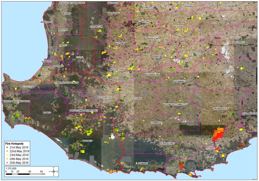
Regions as can be seen from Images 1 and 2.
Image 1. The hotspots for fires in the South West Region detected for 21 through to 25 May
2018. (DFES 2018)
Report of the escaped planned burns in the South West and Great Southern Regions in May 2018 Page 26 of 64Image 2. The hotspots for fires in the Great Southern Region detected for 21 through to 25
May 2018. (DFES 2018)
Of these 196 reported fires, 118 were reported to DFES on the 24 and 25 May. The
table below shows the number of reported fires for the seven local governments
interviewed for the review for the few days prior to the severe weather event and then
proceeding it.
Local Government Reported fires 21-23 May Reported fires 24-25 May
City of Albany 10 43
Shire of Denmark 8 16
Shire of Esperance 0 0
Shire of Harvey 3 9
Shire of Manjimup 7 5
Shire of Plantagenet 1 4
Shire of Ravensthorpe 0 0
Table 2. Number of reported fires to DFES (DFES 2018)
Table 2 is likely to underestimate the number of fires (planned or unplanned) as there is
no requirement to notify DFES of the intention to burn once the RBT has ceased. In this
case, the SW sector of the City of Albany, Shires of Denmark, Esperance, Harvey and
Manjimup did not have RBT in place and may have had more fires on 21 to 23 May.
Image 1 and Image 2 provide a satellite image of the hotspots in the weeks prior to and
including the week of 21 to 25 May, demonstrating the amount of fire in the landscape
Report of the escaped planned burns in the South West and Great Southern Regions in May 2018 Page 27 of 64during May and in particular the number of live burns, depicted as red dots, during the
week of the severe weather event.
There were six planned burns that became bushfires in excess of 50ha across the seven
local governments. These were the Chester Moonah bushfire (Shire of Manjimup),
Napier bushfire (City of Albany), Peaceful Bay bushfire (Shire of Denmark), Redmond
bushfire (Albany), Stirling Range bushfire (Shire of Plantagenet and City of Albany) and
Torndirrup bushfire (Albany). The Napier, Peaceful Bay and Redmond bushfires which
arose from private property burns resulted in the loss of some tourism chalets, one
house, two container sheds, one shed and fencing. The Stirling Range bushfire resulted
in agricultural losses such as fencing, stock, soil and timber plantation assets.
The DBCA undertook a review into the three escapes from the planned burns on their
estate, attached at Appendix 5. Of the three bushfires Chester Moonah, Stirling Range
and Torndirrup, the cause of Chester Moonah was uncertain and may not have been an
escape from the burn, the Stirling Range bushfire resulted from an escape, and the
Torndirrup bushfire was contained by previous planned burning within the National
Park.
5.2 Weather Forecasts and Local Knowledge
The Bureau of Meteorology (BOM) prepared an account of the weather conditions
across the South West of Western Australia during the period leading up to, and
including, the weather event and fire outbreaks of 24 and 25 May (see Appendix 6). The
report includes information about conditions that occurred in previous burning seasons
and the season leading up to the event. It also addressed weather conditions, fire
danger indices, and incident weather forecasts issued between 23 and 26 May 2018.
The approaching strong cold front affecting the entire SWLD was mentioned in the
outlook with forecast dry and gusty northerly winds followed by the arrival of a strong
front late on 24 May, likely to bring heavy rainfall (>30 mm). There was little change to
the outlook over the next four days, with a prediction on 21 May of rainfall of up to 10
mm extending eastwards as far as Albany on 24 May and a rapidly declining rainfall
gradient further to the east. This forecast indicated that on 25 May winds ahead of the
front would be fresh to strong and gusty from north to north-west, corresponding to
surface wind speeds up to about 60 km/hr.
Fire Weather Warnings are issued to the public by BOM when the forecast Fire Danger
Ratings (FDRs) are Severe, Extreme or Catastrophic. The afternoon forecast Fire Danger
Ratings (FDRs) for the Beaufort, Leeuwin, Stirling Coast and Stirling Inland fire weather
districts are summarised in Table 3. Only once did the FDR reach Severe. Public
warnings were predominantly Severe Weather Warnings that focussed on destructive
winds. Public consciousness was, therefore, focussed on risk management associated
with severe storms (rain and wind) rather than fire.
Report of the escaped planned burns in the South West and Great Southern Regions in May 2018 Page 28 of 64Fire Weather Forecast Issued
District 20 May pm 21 May pm 22 May pm 23 May pm
Beaufort High High Very High Very High
Leeuwin High High High High
Stirling coast Very High Very High Very High Very High
Stirling inland Very High High Very High Severe
Table 3. Forecast Fire Danger Ratings for 24 May 2018. (BOM 2018)
The forecast prompted many landowners and managers to ignite burns prior to the
front arriving with the expectation that burns would be complete before the arrival of
the forecasted front and predicted rainfall. Relying on rainfall to assist in securing burns
is a traditional, and mostly successful, risk management practice across the south of the
state utilised by both Government agencies and private land owners to burn windrows,
stubble or other vegetation.
The BOM report notes that the northerly pressure gradient over the South West was
unusually strong during this weather event, ranking equal sixth in strength for May
based on a 67-year climatological period from 1952 to 2018. It was 30 years since a
northerly pressure gradient of this strength was recorded in the month of May.
Despite BOM staff reporting in their Emergency Services Weather Briefing of 23 May
2018 that the southwest of Western Australia typically experiences a front as windy as
this about five time a year, the autumn weather conditions experienced during 24 and
25 May 2018 were uncommon and given the last event was 37 years ago, beyond the
experience of many decision makers. For the most part, contributors to the review
believed BOM’s weather forecast underestimated wind strength and overestimated
likelihood and amount of rainfall. The BOM advice for the Stirling Range provided to
DFES through the Emergency Services Weather Briefing and issued to the Emergency
Services Sector through the BOM registered user pages, indicated that weather
forecasts particularly wind strength and precipitation were reasonably accurate and
consistent.
Several contributors who had lived close to the Stirling Ranges for decades gave
accounts of the localised effects of north-easterly winds including a “rotor” effect
resulting in significantly increased wind speeds and history of no rainfall being
associated with those winds.
The rotor is a closed, vertical circulation that develops in the lee of high mountain
barriers, or in the valley between two mountain ranges, when conditions are
appropriate. The rotor is a form of lee eddy that causes surface wind to flow in the
opposite direction to the gradient wind. Rotors are often associated with extreme wind
speed and turbulence. In the instance of the Stirling Range, light southerly wind was
registered at the Stirling South Automatic Weather Station. The southerly wind factored
with the high wind speeds (80 to 95km/hr) from a northerly direction observed at the
Report of the escaped planned burns in the South West and Great Southern Regions in May 2018 Page 29 of 64You can also read