Naree Budjong Djara Draft Resource Information - June 2020
←
→
Page content transcription
If your browser does not render page correctly, please read the page content below

Naree Budjong Djara
       Draft Resource Information
        Incorporates: Naree Budjong Djara National Park,
Naree Budjong Djara Conservation Park, Myora Conservation Park,
 Main Beach Conservation Park and Minjerribah Recreation Area

                       June 2020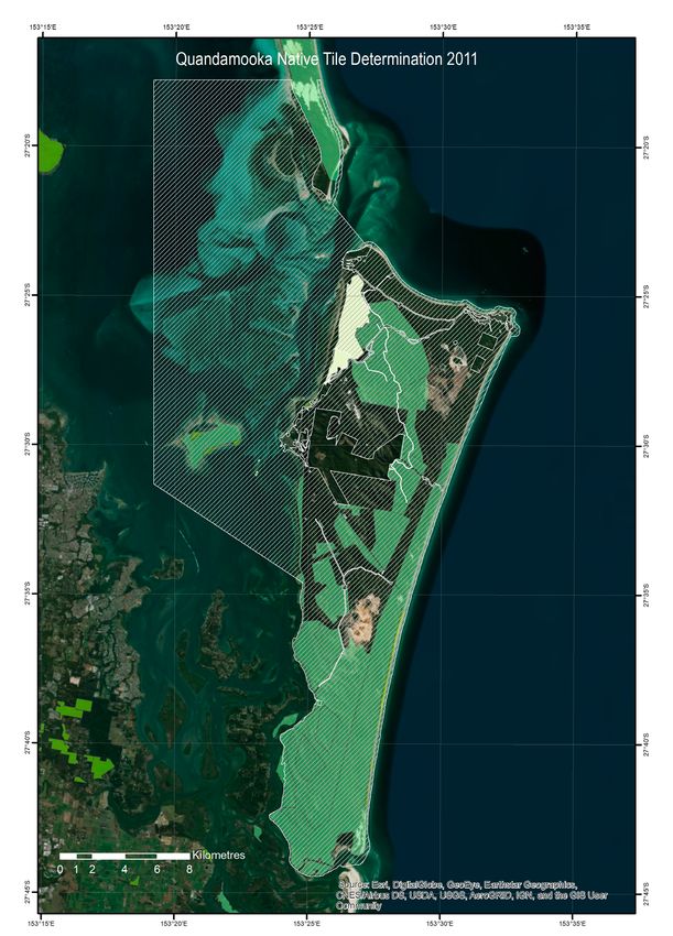
This Resource Information document has been prepared jointly by Quandamooka Yoolooburrabee Aboriginal Corporation (QYAC) and
Queensland Parks and Wildlife Service and Partnerships (QPWS&P), Department of Environment and Science.

© State of Queensland, 2020.

June 2020

Front cover photo: Jagun (Rainbow Serpent) Billabira (Lightning) Jalo (Fire) © Joshua Walker, Quandamooka, 2020

Aboriginal and Torres Strait Islander people should be aware that this document may contain images or names of deceased persons in
photographs and printed material that some people may find distressing.

The Queensland Government supports and encourages the dissemination and exchange of its information. The copyright in this
publication is licensed under a Creative Commons Attribution 3.0 Australia (CC BY) licence.

Under this licence you are free, without having to seek our permission, to use this publication in accordance with the licence terms.

You must keep intact the copyright notice and attribute the State of Queensland as the source of the publication, and QYAC as the
copyright owner in relation to traditional cultural knowledge sections of the publication, as well as acknowledging the Quandamooka
People as the source of that traditional cultural knowledge and site identification information contained in the publication.

The QYAC jointly participated in the preparation of this document and have approved it going to public consultation.

For more information on this licence, visit http://creativecommons.org/licenses/by/3.0/au/deed.en

Disclaimer

This document has been prepared with all due diligence and care, based on the best available information at the time of publication.
QYAC and the department hold no responsibility for any errors or omissions within this document. Any decisions made by other parties
based on this document are solely the responsibility of those parties.

If you need to access this document in a language other than English, please call the Translating and Interpreting Service (TIS National)
on 131 450 and ask them to telephone Library Services on +61 7 3170 5470.

This publication can be made available in an alternative format (e.g. large print or
audiotape) on request for people with vision impairment; phone +61 7 3170 5470 or
email .

Contents
1. Resource information.......................................................................................................................................................................1
2. Naree Budjong Djara........................................................................................................................................................................2
   2.1 Indigenous joint management arrangement................................................................................................................................. 2
   2.2 Naree Budjong Djara ................................................................................................................................................................... 2
   2.3 Quandamooka People................................................................................................................................................................. 4
        2.3.1 Native title.......................................................................................................................................................................... 4
        2.3.2 Quandamooka Yoolooburrabee Aboriginal Corporation....................................................................................................... 6
   2.4 Wetlands of International Importance (Ramsar)........................................................................................................................... 7
   2.5 Ecosystems and biodiversity........................................................................................................................................................ 8
        2.5.1 Regional ecosystems.......................................................................................................................................................... 8
        2.5.2 Important wetlands............................................................................................................................................................ 8
        2.5.3 Wetlands............................................................................................................................................................................ 8
   2.6 Ecosystems services.................................................................................................................................................................... 9
        2.6.1 Water resources.................................................................................................................................................................. 9
        2.6.2 Aesthetic values................................................................................................................................................................. 9
   2.7 Species....................................................................................................................................................................................... 9
        2.7.1 Native animals................................................................................................................................................................... 9
        2.7.2 Native plants...................................................................................................................................................................... 9
   2.8 Geophysical features................................................................................................................................................................. 10
        2.8.1 Geological process of sand island formation..................................................................................................................... 10
        2.8.2 Coastal non-floodplain sand lakes.................................................................................................................................... 10
   2.9 Recreational and ecotourism opportunities............................................................................................................................... 11
        2.9.1 Camping........................................................................................................................................................................... 11
        2.9.2 Day-use areas................................................................................................................................................................... 11
        2.9.3 Beach touring................................................................................................................................................................... 11
        2.9.4 Beach fishing................................................................................................................................................................... 11
        2.9.5 Walking............................................................................................................................................................................ 11
   2.10 Mining.................................................................................................................................................................................... 12
   2.11 Historic cultural heritage......................................................................................................................................................... 12
   2.12 Scientific research................................................................................................................................................................... 12
   2.13 Education................................................................................................................................................................................ 13
   2.14 Fire.......................................................................................................................................................................................... 13
   2.15 Pests....................................................................................................................................................................................... 14
        2.15.1 Pest plants..................................................................................................................................................................... 14
        2.15.2 Pest animals................................................................................................................................................................... 14
Appendices .......................................................................................................................................................................................15
   Appendix 1. Legal, policy and management commitments............................................................................................................... 15
   Appendix 2. Wetlands of International Importance criteria and corresponding Quandamooka country values	���������������������������������� 16
   Appendix 3. Wetland management.................................................................................................................................................. 17
   Appendix 4. Regional ecosystems of significance............................................................................................................................ 18
   Appendix 5. Species of Quandamooka cultural significance............................................................................................................. 19
   Appendix 6. Species of conservation significance............................................................................................................................ 21
   Appendix 7. Species listed in international agreements................................................................................................................... 22
   Appendix 8. Pests ........................................................................................................................................................................... 23
4. References.....................................................................................................................................................................................28

Naree Budjong Djara Resource Information
Draft for consultation
                                                                                                   i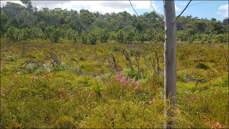
1. Resource information
The Queensland Parks and Wildlife Service (QPWS) is the                               Management plans and statements set the strategic
operational stream of the Queensland Parks and Wildlife Service                       management direction, guiding the next tier of planning and the
and Partnerships (QPWS&P) division within the Department of                           development of thematic strategies, which in turn inform and
Environment and Science (DES). QPWS’s management planning                             prioritise our on-ground operations.
process aligns with the Values-Based Management Framework,
                                                                                      Resource information is a compendium of park information and
an adaptive management cycle that incorporates planning,
                                                                                      a supporting document for management plans and management
prioritising, doing, monitoring, evaluating and reporting into
                                                                                      statements. It contains background information about a park’s
all areas of our business (Figure 1). It is based on international
                                                                                      purpose, values, resources, and legal and administrative
best practice and targets management focusing upon the
                                                                                      framework.
most important features of each park: their key values. In
acknowledging QPWS as a good partner for the protection of
                                                                                      Information about the Values-Based Management Framework is
their lands’ high cultural and natural values, Quandamooka
                                                                                      available on the website at www.des.qld.gov.au.
Yoolooburrabee Aboriginal Corporation (QYAC), representing
the Quandamooke People, have agreed to adopt this joint
management planning approach as the landowners and joint
managers.

 Figure 1. Phases of the VBMF cycle for planning and the hierarchy of planning documents

Naree Budjong Djara Resource Information
Draft for consultation
                                                                                  1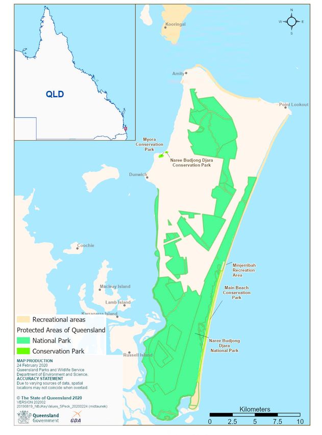
2. Naree Budjong Djara
Nunagal, Goenbal and Ngugi People have always protected our Quandamookadjara (Quandamooka Country)
and managed the health of the ecosystems to allow all species to flourish. QYAC and QPWS aim to provide
best practice joint management of Naree Budjong Djara to ensure lands and culture stay healthy for our
children and for the benefit of all the people of Queensland. We pay our respects to the Elders past, present
and emerging, for their wisdom and knowledge of land and sea on which we work, live and walk.

2.1 Indigenous joint                                                        2.2 Naree Budjong Djara
management arrangement                                                      Naree Budjong Djara means ‘My Mother Earth’ in Jandai
                                                                            language, and refers to the planning area in this document and
In recognition of strong and continuing cultural connections,
                                                                            its accompanying management plan. It is located in Moreton
the Quandamooka People and Queensland Government have
                                                                            Bay, South East Queensland, in the state electorate of Oodgeroo
established perpetual partnerships ensuring that both the
                                                                            and the local government area of Redland City Council. The area
natural and cultural values of protected areas are conserved for
                                                                            is a popular tourist destination, attracting local, interstate and
the benefit of all. On Quandamooka Country, this includes the
                                                                            international visitors, particularly during school holidays, and
joint management of designated protected areas as Indigenous
                                                                            provides island visitors with a variety of natural and cultural
Joint Management Areas (IJMAs), managed in accordance with an
                                                                            visitor experiences, including nature walks, wildlife watching,
Indigenous Management Agreement (IMA) and other agreements
                                                                            nature photography, cultural education opportunities, beach
between the QYAC and the State of Queensland.
                                                                            camping, fishing and four-wheel driving.

The Naree Budjong Djara IJMAs were created during the
                                                                            Naree Budjong Djara National Park was declared on 25 March
negotiations with the Queensland Government to protect the
                                                                            2011 and includes the area previously known as Blue Lake
native title lands of the Quandamooka People as an agreed
                                                                            National Park. The Naree Budjong Djara planning area (Map
approach for the future use of those areas of high conservation
                                                                            1) covers the terrestrial IJMAs on Minjerribah that are jointly
and cultural significance. Quandamooka People continue to
                                                                            managed by QYAC and QPWS within Quandamooka Country. This
use these areas for cultural activities, and have ongoing rights,
                                                                            includes:
interests, commitments and cultural obligations to the park’s
                                                                             •   Naree Budjong Djara National Park
care and management. The continued connection to Country, and
                                                                             •   Naree Budjong Djara Conservation Park
ongoing use, knowledge and protection of cultural resources,
                                                                             •   Myora Conservation Park
is an exercise of their native title rights. An Indigenous Land
                                                                             •   Main Beach Conservation Park
Use Agreement (ILUA) over Naree Budjong Djara recognises the
                                                                            As well as natural coastal areas managed under service
continuing rights and interests of the Quandamooka People. Joint
                                                                            agreement with QPWS by Minjerribah Camping Pty Ltd within:
management arrangements are further explained in the draft
                                                                             • Minjerribah Recreation Area
Naree Budjong Djara Management Plan.
                                                                            See Appendix 1 for legal, policy and management commitments.

                       Bioregion South East Queensland
                             Area 13 000 hectares
          Local government area Redland City                               State electorate                   Oodgeroo
       Management obligations QCD2011/001, QCD2011/002, QC2017/004 Quandamooka Yoolooburrabee Aboriginal Corporation
                                    QI2011/038 ILUA

                                    Directory of Important Wetlands in Australia (DIWA)

                                    Convention on Wetlands (Ramsar)

                                    Convention on the Conservation of Migratory Species of Wild Animals

                                    Japan–Australia Migratory Bird Agreement

                                    China–Australia Migratory Bird Agreement

                                    Republic of Korea–Australia Migratory Bird Agreement

Naree Budjong Djara Resource Information
Draft for consultation
                                                                       2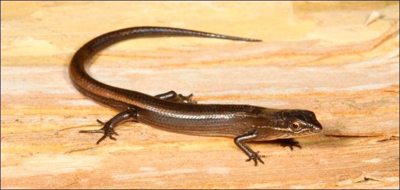
Map 1. Naree Budjong Djara National Park location map. Naree Budjong Djara includes Naree Budjong Djara National Park, Naree Budjong Djara Conservation Park, Myora
 Conservation Park, Main Beach Conservation Park and Minjerribah Recreation Area

Naree Budjong Djara Resource Information
Draft for consultation
                                                                                3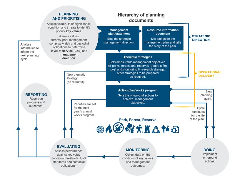
2.3 Quandamooka People                                                    2.3.1 Native title
The Quandamooka People have managed and protected Naree                   In January 1995, the Quandamooka People lodged a native title
Budjong Djara, the surrounding lands and waters of Minjerribah            claim over land and sea encompassing much of Minjerribah, a
and Quandamooka (Moreton Bay) since time immemorial. The                  southern portion of Mulgumpin (Moreton Island), Teerk Roo Ra
Quandamooka People consist of three groups, Noonuccal, Ngugi              (Peel Island), Muppanbillawah (Bird Island) and Goat Island,
and Goenpul, all speakers of Jandai language dialects.                    covering state land comprising national parks, unallocated state
                                                                          land, council reserve and lease lands—all lands not identified
Quandamooka Country extends beyond the scope of the Naree                 as freehold tenure. This native title claim, Quandamooka People
Budjong Djara Management Plan and this resource information               #1, was registered in September 1995. A second claim was
document to other areas that are currently under claim.                   lodged with the Federal Court over land parcels in the north and
                                                                          a large area in the south of Minjerribah in September 1999, and
Naree Budjong Djara contains a wide range of Quandamooka                  registered as Quandamooka People #2 with the National Native
cultural heritage sites, the type, size and densities varying             Title Tribunal in June 2000.
across the area. The Quandamooka People have the oldest
published archaeological occupation site on the east coast                On 4 July 2011, the Federal Court made consent determinations
of Australia, substantiating their continual relationship with            for Quandamooka People #1 and #2 claims at Goompi (Dunwich),
the environment since the Pleistocene epoch approximately                 Minjerribah, and recognised the continuing native title rights over
26 000 years before the present. The importance of cultural               approximately 54 000 hectares of Quandamooka land and sea
sites to the Quandamooka People varies, with some specific                Country. These determinations took effect upon registration of
to men, women and children, and containing valued natural                 the ILUA on 9 December 2011. His Honour Judge Dowsett noted
and cultural resources. These may include plants, animals,                that the determination did not give the Quandamooka People
carefully managed landscapes, shell and bone middens, artefact            anything, merely recognised formally that which they have always
scatters, occupation and camp sites, scar trees, burial sites, fish       had.
traps, ceremonial grounds, pathways and important resource
environments, both the physical and living evidence of long-              The Quandamooka People have non-exclusive possession rights
term and continuing occupation. The Quandamooka People are                over the majority of the determination area. The Quandamooka
progressively recording these sites through the QYAC Cultural             People also have areas of exclusive possession lands (approx.
Heritage Unit.                                                            2 264 ha) that have underlying Crown title (radical title) and
                                                                          recognise their rights to possession, occupation, use and
The Quandamooka People have a long history of managing                    enjoyment to the exclusion of all others from entering lands and
their land and sea Country while providing the resources to               controlling access.
sustain their communities and trade with other groups on the
mainland, such as the Yuggera, Turrbal and Yugembah peoples.              The Quandamooka People’s native title rights over exclusive and
Natural resources key to the Quandamooka community through                non-exclusive lands include:
times past and present include jin/tjin (yugari/pipis), quampi             • the right to live and be present on the area
(pearl oysters), nyandaygal (sea mullet), kinyinggarra (oysters),
                                                                           • the right to conduct ceremonies
yangang (dugong), bunbiya (turtle), sugarbag (honey), dubay
                                                                           • the right to maintain places of importance and areas of
(mudcrab), juwahnduwan (birds), girraman (flying-fox), mari
                                                                              significance to the native title holders
(kangaroo) and giwa (monitors).
                                                                           • the right to teach on the area about the physical and spiritual
The extensive and continued management of Quandamooka                         attributes of the area
Country through jarlo (fire) has ensured the maintenance of                • the right to light fires for the domestic purposes such as
landscapes to facilitate movement, stimulate flowering, enhance               cooking
ecosystem function and diversity, reduce wildfire risk by clearing
                                                                           • the right to take, use, share and exchange traditional natural
thick regrowth, and favour desired environments such as an
                                                                              resources and seawater for any non-commercial purpose.
open woodland with large, old trees in locations of heritage
significance such as historical occupation sites.

The Quandamooka People will continue to manage and protect
Naree Budjong Djara.

Naree Budjong Djara Resource Information
Draft for consultation
                                                                      4
Map 2. Quandamooka native title determination over Minjerribah and parts of Moreton Bay 2011, which covers the Naree Budjong Djara planning area, within Quandamooka
Country
Naree Budjong Djara Resource Information
Draft for consultation
5Traditional natural resources include animals and plants 2.3.2 Quandamooka Yoolooburrabee
as defined within the Nature Conservation Act 1992 (NCA),
Aboriginal Corporation
seaweed, charcoal, shells and resin, any clay, soil, sand, ochre,
gravel or rock on or below the surface of the determination area. Prior to the determination in July 2011 and subsequent ILUA,
QYAC was formed as the Registered Native Title Body Corporate
As part of the Quandamooka People’s native title rights and under the Corporations (Aboriginal and Torres Strait Islander) Act
in retaining a connection to Country, the IMA provides for the 2006 (Cwlth) to act as agent for the native title interests of the
establishment of temporary and permanent living areas within Quandamooka People across recognised Quandamooka land
the existing, and any future additions to, Naree Budjong Djara. and sea Country for both the 2011 and 2019 determinations.
This management plan recognises these rights and confirms QYAC holds in trust the underlying Aboriginal freehold of IJMA
their importance as a component of a number of Naree Budjong tenure, as well as maintaining responsibilities as the registered
Djara’s key values. Future living areas will be authorised through cultural heritage body.
an NCA authority where required, while existing living areas are
provided for in this management plan and within the IMA. Public The Jandai word ‘Quandamooka’ represents Moreton Bay and
access into these living areas is restricted and are managed the islands within it, with ‘Yoolooburrabee’ meaning the ‘people
exclusively by QYAC. of the sand and the sea’. QYAC is agent and legal entity for the
native title interests of the Quandamooka People, land rights,
The Quandamooka People’s Country extends beyond the scope cultural heritage matters and agreements, and holds joint
of this management plan. A native title consent determination for responsibilities with QPWS for planning and works within the
Mulgumpin (Moreton Island) (Quandamooka People #4 claim) IJMAs.
was handed down to the Quandamooka People on 27 November
2019, with registration expected in 2020. Other claims have It remains key to joint management that, with their continuing
been lodged within the southern Moreton Bay areas. connection to Country, the Quandamooka People continue to
be empowered through the joint management process and IMA
to manage Quandamooka Country for its cultural and natural
values.
Naree Budjong Djara Resource Information
Draft for consultation
62.4 Wetlands of International Moreton Bay was listed under the Ramsar Convention on 22
October 1993.
Importance (Ramsar)
The Moreton Bay Ramsar Area within Naree Budjong Djara
Australia is a signatory to the Convention on Wetlands of National Park provides critical ecological services and
International Importance (Ramsar Convention) and has listed environmental benefits including:
66 wetland sites under the Convention, including five in
• a unique diversity of habitats, with many different wetland
Queensland. The Convention seeks to stop the global loss of
types including window lakes, perched lakes, surface
wetlands and to conserve remaining wetlands through wise
expressions and wet heathlands
use and site-appropriate management. As a signatory to the
Convention, Australia agrees to manage these wetlands to protect • Quandamooka cultural heritage values (including significant
their unique ecological character. The Environment Protection and places, resources, stories)
Biodiversity Conservation Act 1999 (Cwlth) (EPBC Act) provides • a wildlife refuge in drought conditions for amphibians, fish,
legislative protection for the Australian-listed Ramsar wetland reptiles, birds and mammals
sites. The Australian Ramsar management principles are outlined • wetland bird and shorebird diversity, abundance and habitat
in Schedule 6 of the Environment Protection and Biodiversity values
Conservation Regulations 2000 and cover the preparation of
• habitat for threatened wetland-dependent fauna (such as
a Ramsar site management plan and community consultation
eastern curlew, Oxleyan pygmy-perch, water mouse)
processes (Australian Government n.d.).
• notable diversity of native wetland fauna of the bioregion
Australia is also a signatory to other international migratory bird • rare and threatened species (such as the lesser swamp
agreements, including: orchid, yellow swamp orchid, swamp daisy)
• Japan-Australia Migratory Bird Agreement, • opportunities for education and research on wetlands
• China-Australia Migratory Bird Agreement, • clean drinking water for south-east Queensland
• Republic of Korea-Australia Migratory Bird Agreement, and • cultural and ecological recreation, education and research
opportunities.
• Convention on the Conservation of Migratory Species of Wild
Animals (Bonn Convention). Naree Budjong Djara satisfied nine of the nomination criteria
available at the time of listing. Appendix 2 sets out the wetland
Migratory species identified in these agreements are also
assessment and key values, which cover and protect these
identified under the EPBC, which provides further support for the
wetland features.
protection of the critical services and benefits of the Moreton Bay
Ramsar site.
The Quandamooka People are the custodians and native
titleholders of the Moreton Bay Wetland of International
Importance and have been responsible for managing the
land and sea environments for many thousands of years. The
wetlands—freshwater and estuarine—are of particular importance
to the Quandamooka People’s tangible and intangible cultural
heritage. The wetland environments are integral to creation
stories, traditional food gathering, processing and land
management techniques. The distinct traditions, natural resource
management, technical innovation and expertise in processing
food, fibre and other materials associated with these wetlands
should be considered and recognised in any review or updates of
the listing, as noted at the 12th Meeting of the Conference of the
Parties to the Convention on Wetlands, June 2015, and outlined
in Resolution XII.2 of The Ramsar Strategic Plan 2016–2024
(Ramsar 2015).
Naree Budjong Djara Resource Information
Draft for consultation
72.5 Ecosystems and biodiversity on coastal dunes and sandplains (RE 12.2.10), scribbly gum
Eucalyptus racemosa subsp. racemosa open forest on dunes and
sand plains (12.2.6), and closed sedgeland coastal swamps (RE
The diversity of aquatic habitats provides excellent examples of 12.2.15) (Naree Budjong Djara, Comprehensive, Adequate and
largely undisturbed artesian window lakes, spring-fed creeks, Representative Report (assessed 28 August 2019)).
perched lakes and groundwater-dependent vegetated wetlands.
Bummiera (Brown Lake) is the largest lake, a perched sphagnum
bog, with a surface area of 24 hectares. Karboora (Blue Lake) is 2.5.2 Important wetlands
a window lake, an opening to the aquifer, with a surface area of
Naree Budjong Djara is contained wholly within the North
9ha. The lakes, along with the numerous swamps and lagoons
Stradbroke Island Important Wetland, QLD191 (27 424 hectares),
such as Eighteen Mile Swamp, which stretches almost the entire
listed on the Directory of Important Wetlands (Department
length of the eastern coastline, provide major freshwater habitats
of the Environment and Energy n.d.). The North Stradbroke
for a variety of migratory bird species. These wetlands, foreshore
Island Important Wetland is contained within the Moreton Bay
swamps and interconnecting land are listed as part of the
aggregation, QLD134 (254,364ha), and contains both marine
Moreton Bay Ramsar site. Threatened fauna species protected
and coastal zone (A) and inland (B) wetland types (Figure 2).
through conservation of these wetland habitats include Cooloola
sedgefrog Litoria cooloolensis (including the Minjerribah sub-
population), wallum sedgefrog Litoria oblongurensis, wallum 2.5.3 Wetlands
rocketfrog Litoria freycineti, wallum froglet Crinnia tinnula, grey-
Minjerribah is unique in the number of wetlands dating to the
headed flying-fox Pteropus poliocephalus, water mouse Xeromys
Last Glacial Maximum. The persistence of these wetland systems
myoides and the Oxleyan pygmy perch Nannoperca oxleyana,
suggests that the Minjerribah has experienced a positive water
with flora species including the swamp daisy Olearia hygrophila,
balance for more than 40 000 years (Tibby et al. 2017).
lesser swamp orchid Phaius australis and yellow swamp orchid
Phaius bernaysii. On Minjerribah, the most important processes influencing
the formation and maintenance of inland wetlands is aquifer
discharge (expression wetlands and springs), aquifer recharge
2.5.1 Regional ecosystems
(window lakes), rainfall, and peat accumulation (perched
Naree Budjong Djara contains 16 regional ecosystems (REs) lakes). Lateral groundwater expressions maintain a freshwater
(Appendix 4), three of which are ‘endangered’, five are ‘of lens, preventing seawater intrusion into Minjerribah’s aquifer.
concern’ and eight are ‘not of concern’. Naree Budjong Minjerribah’s perched coastal lakes on sand are of global
Djara contains the largest contiguous remnant patch of the importance as there are only 80 of these systems worldwide.
‘endangered’ open heath on dunes (RE 12.2.13). This naturally
rare RE covers over 240 hectares of Naree Budjong Djara, Some wetlands have been impacted by modified hydrology,
accounting for approximately 70 per cent of the total remnant interference with layers of induration (hardening) and a changing
area of this RE in Queensland. Naree Budjong Djara also contains climate. Partnerships with various research bodies continue to
a significant area of the ‘of concern’ stringybark Eucalyptus improve joint management’s understanding of the importance,
planchoniana, scribbly gum Eucalyptus racemosa, red bloodwood sensitivity, history and roles that wetlands play in Quandamooka
Corymbia gummifera and banksia Banksia aemula woodland Country.
Figure 2. Naree Budjong Djara wetlands have high
plant diversity and support several threatened
species, Canalpin Swamp © QYAC 2019
Naree Budjong Djara Resource Information
Draft for consultation
82.6 Ecosystems services 2.7 Species
2.6.1 Water resources 2.7.1 Native animals
Minjerribah’s reliable groundwater resources currently provide Naree Budjong Djara supports a variety of native animals typical
the South East Queensland water grid with water supply from of the South East Queensland Bioregion, including 16 species
a series of extractive bores. It is currently not known whether of frogs, 11 species of fish, 30 species of reptiles, 127 species
drawdown upon this resource is sustainable in the medium of birds and 21 species of mammals. There are 17 conservation
to long term, with increasing demand both evident and significant species, including four frogs, one fish, seven birds and
forecast from an increasing mainland population and growing five mammals (Appendix 6 & 7). Twenty-two species are listed
development along the Quandamooka coast. Community on international agreements; Convention on the Conservation
concern about the water level at Bummiera (Brown Lake) has of Migratory Species of Wild Animals, Japan–Australia Migratory
increased in recent years. It is understood that Bummiera’s Bird Agreement, China–Australia Migratory Bird Agreement and
water level as of 2018 is the lowest on record, with a limited Republic of Korea–Australia Migratory Bird Agreement.
understanding of the cause of the reduced level.
Minjerribah and Naree Budjong Djara support four conservation
Groundwater-fed creeks along the western coast of Minjerribah significant frog species, which are dependent on the high number
supply several unserviced dwellings in the Moopi Moopi Pa (One of geologically stable acid lakes and swamps that occur on the
Mile), Moongalba and Myora area with a back-up water supply island. These wetlands are important Quandamooka People
when rainwater tanks are low. cultural values and the Quandamooka People believe that by
looking after Country, these and other important species will be
protected. The Minjerribah and Naree Budjong Djara population
2.6.2 Aesthetic values
of the Cooloola sedgefrog Litoria sp. cf. cooloolensis (North
While presenting much more than scenic amenity in the way Stradbroke Island population) is considered genetically distinct
of cultural and natural landscape values, Naree Budjong Djara from the mainland population.
features long surf beaches, vegetated sand dunes and exposed
sand blows, dry to wet sclerophyll forest, heathlands and A disjunct population of the heath shadeskink Saproscincus
sedge-dominated swamplands. Visitors walking the Neembeeba oriarus (Figure 3) occurs on Minjerribah and Naree Budjong
lookout track can see stunted eucalypts south towards the Gold Djara, with the nearest mainland population occurring in northern
Coast and the Pacific Ocean. New South Wales. Other significant reptile species include the
death adder Acanthophis antarcticus, which has declined in other
areas, most likely as the result of poor fire management.
Minjerribah, including Naree Budjong Djara, is renowned for its
significant koala population. The Minjerribah–Naree Budjong
Djara koala population appears to be stable and does not face
Figure 3. Naree Budjong Djara supports a disjunct the threats experienced by the adjacent mainland population. In
population of the heath shadeskink Saproscincus
an effort to protect the Minjerribah–Naree Budjong Djara koala
oriarus © H.B. Hines 2019, QPWS
population, QYAC enforces a strict quarantine protocol where
sick or injured koalas removed from the island for veterinary
treatment are not to be returned to the island after treatment.
2.7.2 Native plants
Naree Budjong Djara supports 239 species of native plants
typical of the South East Queensland Bioregion. There are eight
conservation significant species, including several species with
restricted distributions (Appendix 6). Eleocharis difformis and
Olearioa hygrophila are considered to have evolved as a result of
the age and stability of the island’s wetlands (Tibby et al. 2017).
Naree Budjong Djara Resource Information
Draft for consultation
92.8 Geophysical features 2.8.2 Coastal non-floodplain sand lakes
Minjerribah’s lake systems consist of a range of classifications
2.8.1 Geological process of sand island including perched lakes, lowland lakes on leached dunes,
formation freshwater lakes with marine contact, ponds in frontal dunes,
and a water table window lake. The freshwater systems
Minjerribah and Naree Budjong Djara represent a significant,
are typically characterised by acidic chemistry, low levels
ongoing geological and biological process of accumulative
of suspended solids and nutrients, and beds of humic
quartz sand deposits. The sand dunes present on Minjerribah
accumulation. Perched lakes on Minjerrabah are formed on an
today result from the formation of sandbanks running south
indurated layer of cemented organic material and sand within
from the Mooloomba headland during low sea levels of the
the soil profile. This creates a semi-permeable perching layer,
Early Pleistocene period and high sea levels prior to the Middle
which infiltrating groundwater and rainfall can fill rapidly.
Pleistocene period. Migrating sands accumulated against the
Perched lakes, such as Bummiera, may be characterised by their
rhyolite formations of Mooloomba and greenstones outcrops
‘tea’ colouration due to the tannin content of the water leached
approximately 15 km south of Dunwich. These sandbanks were
from the organic materials present in high levels. Window lakes
formed by ocean currents when they were submerged a number
present on Minjerribah, such as Karboora, are systems between
of times through glacial periods, with mineral-rich deposits
dunes that intercept the groundwater table, thus forming a
forming across the banks. The north-western migration and
‘window’ into the aquifer. Karboora is a highly stable system with
accumulation of sand was aided by windblows when sandbanks
a constant water level, and displays a high degree of resilience to
emerged during low sea-level periods during the late Pleistocene.
climatic variation over millennia.
A final recession of sea level following this period resulted in the
emergence of stable, high-dune landform systems present across
Groundwater expressions along the eastern coastline are
the majority of Minjerribah. The active north-trending dunal
confined by frontal dune systems, forming the Eighteen Mile
formation on the eastern beaches that are present today, and
Swamp, a vegetated system varying in depth. Fire exclusion,
enclose the Eighteen Mile Swamp, began to form at this time.
inappropriate fire and fluctuating water levels have seen an
intrusion of ngudjur (broad-leaved paperbark) Meleleuca
quinquenervia and an altered composition of sedge and rush
communities.
Naree Budjong Djara Resource Information
Draft for consultation
102.9 Recreational and ecotourism 2.9.3 Beach touring
opportunities Four-wheel driving along Flinders Beach and Main Beach is
a popular attraction of Minjerribah. Access is restricted to
Minjerribah is about 40 km south-east of Brisbane and is a
designated areas and requires a vehicle access permit. Driving
popular tourism destination, with between 320 000 and 380 000
on the beach is not permitted one hour either side of high tide.
people visiting in 2017. Visitors are encouraged to enjoy learning
Access may be restricted or closed for safety or environmental
about Quandamooka culture, landscapes, values and knowledge
reasons. Restrictions and closures are clearly signed.
while visiting, beach camping at Flinders Beach and Main Beach,
bushwalking, appreciating nature, and enjoying the four-wheel-
drive beach experience. 2.9.4 Beach fishing
Fishing is prohibited within the inland water bodies of
Through joint management, QYAC and QPWS wish to promote,
Minjerribah and Naree Budjong Djara. However, Main Beach and
enhance and elevate Quandamooka cultural awareness among
Flinders Beach offer more than 40 km of coastline for recreational
visitors to further enrich the eco-cultural experience on offer.
beach fishing and are accessible by four-wheel-drive with a
Joint management seeks to encourage culturally appropriate and
vehicle access permit. Surf gutters along Main Beach and the
respectful behaviour when visiting or conducting commercial
South Passage from Flinders Beach provide fishing opportunities
activities on Naree Budjong Djara.
for species such as tailor, whiting and dart.
2.9.1 Camping
2.9.5 Walking
Beach camping is available at Flinders Beach and Main Beach
There are five walking tracks within the Kaboora section of Naree
within the Minjerribah Recreation Area. These are self-sufficient
Budjong Djara. All tracks are accessible from the Kaboora car
unallocated camping sites accessible only by four-wheel-drive
park, about 9 km from Goompi (Dunwich) along Alfred Martin
vehicles. Four-wheel-drives require an access permit available
Way.
from Minjerribah Camping. Flinders Beach, a north-east to
north-facing beach stretching for 8 km, features 200 sites across
Neemeemba track
12 zones, accessible by four-wheel-drive along beach and
The Neembeeba (‘to see’) lookout track is a 6 km return walk.
bush tracks. Main Beach extends 38 km along the eastern side
The track departs the car park and winds uphill through coastal
of Minjerribah, and features 160 sites across 15 zones, also
wallum woodland to a sandy ridge where views of the ocean
accessible by four-wheel-drive along the beach. The camping
can be seen through the trees. The vegetation is stunted with
zones begin 17 km south of Point Lookout. Dogs are permitted
distinctive scribbly gums. The lookout provides views over the
and must be on a lead at all times.
southern part of Minjerribah, the Pacific Ocean and the Gold
Coast. The track is a gradual climb and is sandy in places.
2.9.2 Day-use areas
Dakabin track
The Bummiera day-use area is located 3.5 km from Goompi The Dakabin (‘grass tree’) track is a 1.8 km section of walking
(Dunwich) and features several wood-fired barbecues, picnic track that connects the Neembeemba lookout to the shores of
facilities and toilets. Kaboora. It winds through tall grass trees, heath, pockets of ferns
and native grasses.
Myora Springs Conservation Park offers a boardwalk along
Capemba (Myora) Creek, and features interpretive signage telling Kaboora track
the story of this significant Quandamooka site, winding through The Kaboora (meaning ‘deep silent pool’) track is a 5.2 km
the endangered littoral scrub out to the mangrove forest and return walk. Kaboora is a place of significant cultural value to the
Moreton Bay. Quandamooka People and they request that visitors respect the
significance of the area by not swimming in the lake.
Naree Budjong Djara Resource Information
Draft for consultation
11The walk to Kaboora passes through wallum woodlands
with stunted eucalypt trees, wallum banksias and a heath
2.10 Mining
understorey. The edges of the lake are thickly vegetated with Commencing in the 1950s, sand mining has played a key role in
eucalypts, banksias and sedges, with many birds such as Minjerribah’s economic history. Through negotiation between the
honeyeaters and lorikeets. The lake supports waterbirds, such as State, QYAC and mining operators, and with legislative change,
grebes and ducks, as well as several species of native freshwater sand mining ended substantially by late 2019, and is due to be
fish including ornate rainbowfish and gudgeons. Visitors may phased out by 2025.
catch sight of a golden wallaby Wallabia bicolor, a form of swamp
wallaby found only on Teerk Roo Ra (also known as Peel Island), Large areas of Minjerribah, portions of Naree Budjong Djara, and
Minjerribah and South Stradbroke Island. In wet times, you can new additions through the Minjerribah Protected Area Expansion
hear the call of the near-threatened Cooloola sedgefrog Litoria Strategy have been subject to mineral sands exploration and
coolooensis. mining, followed by rehabilitation. Rehabilitated areas present
a range of management considerations from a fire, species
Kabul track composition, pest, landform and hydrology perspective.
The Kabul (carpet snake) track starts from the western side of
the day-use area. It is a 3 km section of track that follows the
ridgeline south-east then drops downhill to connect with the
Kaboora track, passing through dwarfed eucalypts and offering
2.11 Historic cultural heritage
spectacular views to Mount Vane and the ocean. There are no sites on Naree Budjong Djara listed on the
Queensland Heritage Register or the Australian National Heritage
Jarlo Beetle track list.
The Jarlo beetle (fire beetle) track starts after the steepest
section of the Kabul track. It is a 6 km return walk that follows the
ridgeline west through twisted scribbly gums and forest boronia,
then up to the summit where there are views south to the Gold
2.12 Scientific research
Coast, west to Brisbane and north to the Glass House Mountains QPWS and QYAC have several long-term monitoring programs.
and Sunshine Coast. Research programs such as koala population monitoring,
limnology and cultural heritage surveying inform and guide
decision-making and management to prioritise the protection of
natural and cultural values.
Naree Budjong Djara offers great opportunities for research into
geomorphological processes associated with perched lake and
window lake systems, swamps and wetlands, and the values of
Minjerribah as a refuge for climate change.
Through the joint management process, a return to a traditional
burning regime is being implemented. This change in
management has research potential for a greater understanding
of traditional land management practices.
The University of Queensland Moreton Bay Marine Research
Station, QYAC and QPWS have developed a strong working
relationship through natural resource monitoring and research
projects.
Naree Budjong Djara Resource Information
Draft for consultation
122.13 Education A history of lack of jarlo fire practice across Minjerribah and
Naree Budjong Djara has resulted in regular occurrences of
Naree Budjong Dara offers visitors the chance to enjoy and high-intensity wildfire events. Subsequent thickening of she-
learn through nature-based recreational activities, and gain oak regrowth in open forest, melaleuca in swamps and edges,
knowledge and a greater understanding of the rich history of the and obligate-seeder species has elevated fuel loads and the
Quandamooka People and their culture, use and management of likelihood of high-intensity fires, increasing the difficulty
native plants and animals, and natural processes associated with in applying the appropriate burning regime during optimal
Minjerribah and Naree Budjong Djara. conditions. Increased fuel loads threaten cultural landscapes,
precincts, sites and natural key values.
Public appreciation of the cultural importance of Minjerribah
to the Quandamooka People can be greatly enhanced through The Quandamooka Jarlo (Fire) Project presents a rationale
emphasising Quandamooka culture and story places such as and strategy to implement tradition burning while the
Mooloomba, Bummiera and Karboora. Minjerribah Township Fire Management Strategy considers
the fire risk proximate to the townships on Minjerribah. To
Naree Budjong Djara provides an ideal natural resource for formal achieve a traditional burning regime, the strategy classifies
and informal education. School groups, tertiary institutions, local areas surrounding the townships as hazard reduction zones
community members and interest groups use Naree Budjong at varying degrees and identifies overall fuel loads as triggers
Djara to study the processes associated with coastal dune for fire management. These township protection zones are to
systems, lakes, swamps, and wetlands, and native plant and allow a traditional fire regime to occur across Naree Budjong
animal ecology. Organised educational group activities within Djara and the rest of Minjerribah and minimise the risk of fire
Naree Budjong Djara require the consent of QYAC and QPWS. impacting on the townships. A reduced risk of wildfire allows for
greater participation of the wider Quandamooka community in
QYAC plans to establish a cultural and visitor centre at jarlo practices, achieving the overall goals of Healthy Country,
Goompi to enhance visitor appreciation and understanding of Healthy People throughout the Quandamooka community. A
Quandamooka culture upon their arrival at Minjerribah and Naree fire management trail network is being developed across Naree
Budjong Djara. Budjong Djara and adjoining tenure to provide maintained
access and management infrastructure throughout the estate.
2.14 Fire Fire management across Minjerribah and Naree Budjong Djara
seeks to involve a wide range of partners and stakeholders.
To date, fire management has occurred through planned Primarily, fire management is undertaken by the QYAC and
hazard reduction burns and wildfire response. Long-term QPWS joint management unit. Assistance is sought from other
fire management seeks to adopt a collaborative traditional agencies when required for planned burns and wildfire response,
burning regime across Minjerribah and Naree Budjong Djara by including Queensland Fire and Emergency Services, Queensland
implementing the Quandamooka Jarlo (Fire) Project. The aim of Rural Fire Service, Department of Natural Resources, Mines and
the Jarlo Project is to reintroduce traditional fire management Energy, Seqwater, Redland City Council, Minjerribah Camping
to re-create the pre-colonisation cultural landscape, in turn and Sibelco.
achieving the Quandamoooka People’s vision of Caring for
Country, and reducing fire risk to cultural and natural values,
townships, settlements and recreation areas.
The South East Queensland Bioregion of Queensland Planned
Burn Guidelines (NPRSR 2012) outlines the strategies for
implementing appropriate fire management regimes in the
various vegetation types within the protected area estate of the
South East Queensland Bioregion. The QYAC and QPWS joint
management unit undertakes planned burns in accordance with
these guidelines, with a focus on integrating Quandamooka jarlo
knowledge into planned burn operations.
Naree Budjong Djara Resource Information
Draft for consultation
132.15 Pests the effectiveness of firebreaks and increase maintenance
requirements, but also increase fuel loads and alter the fire
regime when spreading into natural areas.
2.15.1 Pest plants
Environmental weeds have the potential to impact the key values 2.15.2 Pest animals
of Naree Budjong Djara. These include widespread species
such as basket asparagus Asparagus aethiopicus ‘Sprengeri’, Eleven terrestrial vertebrate pests, including feral cat Felis catus,
lantana Lantana camara, guava Psidium guajava, groundsel bush wild dog Canis lupus, fox Vulpes vulpes, house mouse Mus
Baccharis halimifolia, Easter cassia Senna pendula var. glabrata, musculus, black rat Rattus rattus, cane toad Rhinella marina,
Singapore daisy Sphagneticola trilobata, umbrella tree Schefflera spotted dove Streptopelia chinensis, common myna Acridotheres
actinophylla, mile a minute Ipomoea cairica, red ochna Ochna tristis, house gecko Hemidactylus frenatus, mosquitofish
serrulata and broad-leaf pepper-tree Schinus terebinthifolius. Gambusia holbrooki and tilapia Oreochromus mossambicus,
As many of these species are well established throughout Naree have been recorded on Minjerribah and Naree Budjong Djara
Budjong Djara, management focuses on infestations that impact (Appendix 8).
the key values (Appendix 8).
Feral cats and foxes impact on marine turtle nests, and small
Pest plants that threaten the integrity of the numerous wetlands mammal and bird populations across Minjerribah and Naree
include groundsel bush Baccharis halimifolia, a wind-dispersed Budjong Djara. They have been identified as a significant risk to
shrub capable of establishing where saltwater intrusion may several threatened species including water mouse and several
occur and where native species may have a lower threshold of migratory shorebirds. A multi-agency/tenure approach to fox
resilience. The ability of ecosystems to recover following intrusion management across Minjerribah has reduced fox numbers
is hampered by the establishment of groundsel populations, through a 1080 baiting, shooting and trapping program
resulting in an environment that allows further establishment of coordinated by the Straddie Pest Management Group. Feral cat
groundsel bush. Appropriate burning practices and management management is currently limited to trapping and seeks to identify
of wetland outflows and estuarine inflows are necessary to priority target areas for feral cat management.
manage groundsel bush.
Mosquitofish are established in several creeks, lakes and
Some areas are a legacy of sand mining, now rehabilitated swamps across Minjerribah and Naree Budjong Djara.
through remedial earthworks and revegetation. Coastal tea-tree Mosquitofish present a threat to native fish and amphibians in
Leptospermum laevigatum, a native species to south-eastern water bodies, including being highly competitive for resources
Queensland, is now considered naturalised in parts of the with the vulnerable Oxleyan pygmy perch Nannoperca oxleyana.
region. Coastal tea-tree was used extensively for stabilisation in The population of Cooloola sedgefrog Litoria coolooensis within
sand mining rehabilitation. It has potential to hybridise with the Bummiera has been impacted considerably following the
endemic Leptospermum species and outcompetes the endemic introduction of mosquitofish to the lake in 2003, with the wallum
species, not only through growth on sand mine rehabilitation sedgefrog Litoria oblongurensis and wallum rocketfrog Litoria
areas, but through dispersal into natural areas such as wetlands. freycineti being predated through introductions to other aquatic
The potential to alter fuel loads may also pose a threat to invaded systems on Minjerribah. Additionally, reported sightings of the
environments. noxious Mozambique mouthbrooder or tilapia Oreochromus
mossambicus have occurred in the Kounpee Trench, an artificial
Historically, several exotic pine plantations have been water source to service sand mining, south of Goompi. Tilapia’s
established across Minjerribah and Naree Budjong Djara. Mature ability to occur at high density and consume resources, from
slash pine Pinus elliotti and stands of pine wildings are present detritus to live fish, presents a significant threat to the aquatic
and pose a threat to biodiversity through shading understorey ecology of Minjerribah.
species, increasing fuel loads and altering fire regime.
An emerging threat to biodiversity on Minjerribah and Naree
Whiskey grass Andropogon virginicus occurs across Minjerribah Budjong Djara is wild domestic dogs. Some dogs accompanying
and Naree Budjong Djara. Typically an invader of disturbed visitors and local residents have become ‘wild’ and killed
areas such as roadsides, the presence of whisky grass along large mammals such as koalas and grey kangaroos. QYAC and
constructed firebreaks has the potential to not only reduce QPWS are working with Redland City Council to manage wild
domesticated dogs.
Naree Budjong Djara Resource Information
Draft for consultation
14Appendices
Appendix 1. Legal, policy and management commitments
Gazettal details
Blue Lake National Park was gazetted in 1980 to protect the area’s cultural and natural values. Blue Lake National Park is now part of
Naree Budjong Djara National Park. In July 2011, the Federal Court of Australia handed down its determination of native title to the
Quandamoooka People, delivering an ILUA and IMA. Following the native title determination and the gradual extinguishment of sand
mining leases across the island, Naree Budjong Djara National Park has become an Indigenous Joint Management Area.
Applicable Acts and statutory powers
• Aboriginal Cultural Heritage Act 2003 (Qld)
• Biosecurity Act 2014 (Qld)
• Environment Protection and Biodiversity Conservation Act 1999 (Cwlth)
• Mining and Quarrying Safety and Health Act 1999 (Qld)
• Mineral Resources Act 1989 (Qld)
• Native Title Act 1993 (Cwlth)
• Nature Conservation Act 1992 (Qld)
• Queensland Heritage Act 1992 (Qld)
• Recreation Areas Management Act 2006 (Qld)
Management obligations
• Quandamooka Indigenous Land Use Agreement June 2011
• Moreton Bay Ramsar Site Agreement 1993
Recovery plans and guides
• National recovery plan for the wallum sedgefrog and other wallum-dependent frog species, 2006.
• National recovery plan for the littoral rainforest and coastal vine thickets of Eastern Australia ecological community, 2019.
Other management commitments
• CMS – Convention on the Conservation of Migratory Species of Wild Animals
• CAMBA – China–Australia Migratory Bird Agreement
• JAMBA – Japan–Australia Migratory Bird Agreement
• ROKAMBA – Republic of Korea–Australia Migratory Bird Agreement
Naree Budjong Djara Resource Information
Draft for consultation
15You can also read