A Study of the Active Parabolic Dune in North Beach Park, Ottawa County, Michigan
←
→
Page content transcription
If your browser does not render page correctly, please read the page content below
A Study of the Active Parabolic Dune
in North Beach Park, Ottawa County, Michigan

                     A report to
 the Ottawa County Parks and Recreation Commission
      and Construction Aggregates Corporation

                 September 2004

                 Kristy Jamieson
                 Deanna van Dijk

        Department of Geology, Geography
            and Environmental Studies
                 Calvin College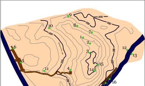
Table of Contents
1.0 Report Summary .................................................................................................................1
2.0 Introduction.........................................................................................................................2
    2.1 Objectives .....................................................................................................................2
    2.2 The Study Area in North Beach County Park...............................................................2
    2.3 What is a parabolic dune? .............................................................................................4
3.0 Methods...............................................................................................................................6
    3.1 Surveying ......................................................................................................................6
    3.2 Assessing Dune Activity...............................................................................................7
    3.3 Observing Human Activity...........................................................................................9
    3.4 Coastal Dune Management ...........................................................................................9
4.0 Results.................................................................................................................................9
    4.1 Dune Topography .........................................................................................................9
    4.2 Dune Regions..............................................................................................................12
    4.3 Dune Migration...........................................................................................................16
    4.4 Human Activity...........................................................................................................17
5.0 Discussion .........................................................................................................................18
6.0 Coastal Dune Management ...............................................................................................21
    6.1 Mechanical shaping of the dune ..................................................................................21
        6.1.1 Removing dune sand..........................................................................................20
        6.1.2 Replenishing dune sand .....................................................................................21
        6.1.3 Reshaping the dune .............................................................................................21
    6.2 Surface stabilizers .......................................................................................................22
        6.2.1 Stabilizing the surface with chemicals...............................................................22
        6.2.2 Organic materials to stabilize surface .................................................................22
        6.2.3 Armoring the surface with inorganic materials ..................................................22
    6.3 Sand fences .................................................................................................................23
    6.4 Planting vegetation......................................................................................................24
        6.4.1 Afforestation .......................................................................................................24
        6.4.2 Planting with non-native species ........................................................................24
        6.4.3 Planting with native species such as Ammophila breviligulata ..........................25
    6.5 Managing human activities .........................................................................................25
        6.5.1 Keeping people away from sensitive areas .........................................................25
        6.5.2 Elevated boardwalks ...........................................................................................26
        6.5.3 Education ............................................................................................................26
    6.6 Managing dunes as naturally dynamic landforms ......................................................27
        6.6.1 No or limited interference with dune activities...................................................27
        6.6.2 Limited stabilization ...........................................................................................27
        6.6.3 Remobilizing dunes ............................................................................................27

                                                                        i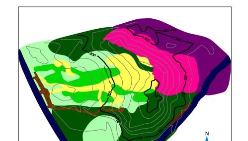
7.0 Recommendations for North Beach Park .........................................................................28
    7.1 Recommendation 1 .....................................................................................................28
    7.2 Basis for recommendations concerning parabolic dune in North Beach Park............29
    7.3 Recommendation 2 .....................................................................................................29
    7.4 Recommendation 3 .....................................................................................................31
    7.5 Recommendation 4 .....................................................................................................32
    7.6 Recommendation 5 .....................................................................................................32
8.0 Conclusions.......................................................................................................................33
9.0 Acknowledgements...........................................................................................................34
10.0 Works Cited .....................................................................................................................34
11.0 Appendices......................................................................................................................36

                                                                     ii
1.0 Report Summary
         The activity of a large parabolic dune in North Beach Park, Ottawa County, Michigan,
was the focus of a study in the summer of 2004. Located on Lake Michigan near Ferrysburg, the
dune is part of a popular county park which includes a recreational beach, playground, picnic
shelter, parking lot, wooden dune stairway and dune overlook deck. The crest and slipface of the
parabolic dune are owned by Construction Aggregates Corporation. The only access road to the
park and to dozens of houses on the Lake Michigan coast is North Shore Road which curves
around the landward side of the parabolic dune before reaching the park. There has been recent
cause for concern because of observed sand movement towards North Shore Road. If the dune is
moving and it eventually covers the road, the dune will cut off access to the neighborhood and
the recreational area. The goal of this study was to investigate the current characteristics of the
active parabolic dune and to make recommendations about future dune management.
         The status of the parabolic dune was studied by surveying the dune with an electronic
total station. At each survey point, location and elevation were recorded along with the type of
surface cover, such as bare sand, forest, pathway, marram grass or recent sand deposit. The
survey data were used to generate maps showing dune shape and regions of surface cover and
activity. In 1997, park staff installed four posts which they used to monitor slipface advance.
Data from these posts were used to determine the rate of dune movement for the last seven years.
Types and locations of human activity on the dune were recorded during the field studies.
         Study results show that the dune has a height of 45 meters and a total area of 64,750m2.
The migration rate of the dune has increased from no observable advance in the first year of post
measurements (1997-1998) to 0.67 m/year advance of the slipface in 2004. The main direction
of dune movement is due east towards North Shore Road. At a rate of 0.67 m/year, the leading
edge of the dune will reach the road—a distance of 12 meters—in 18 years. The supply of sand
for the dune’s migration is a 4,678m2 area on the upper windward slope of the parabolic dune
where human activities such as hiking and running down the center of the dune, along with
decreased vegetation, permit the wind to remove large amounts of sediment. The sand is
transported by wind over the crest of the dune and deposited on the upper part of the dune
slipface. Slope processes, assisted by people running, walking and sliding down the slope, move
sand to the bottom of the slipface and cause the dune advance.
         Dune migration can be slowed by implementing some management strategies to stabilize
dune areas. Management techniques that have been used on other dunes include mechanical
shaping of the dune; stabilizing dune surfaces with materials, fences, and planting vegetation;
and managing human activities on dunes. Recommendations for managing the North Beach Park
dune are based on assumptions that the road location should be retained and the dune should be
preserved as a natural and recreational area. We recommend that the most active areas—the
upper backslope, crest and upper slipface of the dune—be stabilized with fences and/or surface
cover to slow down sand movement, planted with Ammophila breviligulata (American beach
grass), and be made zones for restricted human activity until the road is no longer in danger.
Monitoring of dune activity should be continued to keep track of dune advance and assess the
success of management activities.

                                                1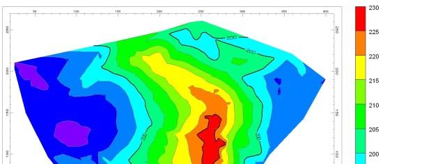
2.0 Introduction
        North Beach Park, in Ottawa County on the east coast of Lake Michigan, is a popular
recreational area that includes a large parabolic dune. The crest and slipface of the parabolic
dune are owned by Construction Aggregates Corporation. The county park has only a single
access road, North Shore Road, which curves around the east and south sides of the parabolic
dune before reaching the park and providing access to dozens of houses along Lake Michigan to
the north and south of the park. The dune is separated from the recreational beach and
playground by the park parking lot and an entry road to the neighborhood north of the park.
Patrons of both the beach and the coastal vicinity use the dune for multiple purposes.
        Recently observed sand movement towards North Shore Road has prompted concern
about whether the parabolic dune is moving inland. Local residents and authorities are
concerned because of the possibility that the dune might move over the North Shore Road; if the
dune does cover the road, it will cut off access to the neighborhood and recreational area. This
report describes a study to document the characteristics of the parabolic dune, including its
morphology, activity, vegetation cover, and types of human activities, as well as to make
recommendations about future dune management.

2.1 Objectives
       The purpose of this study is to describe the activity of the parabolic dune and to outline
possible management strategies. Study objectives are:
       1) To assess and describe the current activity of the parabolic dune,
       2) To predict the range of future dune activity,
       3) To describe possible management strategies for the parabolic dune, and
       4) To make recommendations to the Ottawa County Parks and Recreation Commission
          and Construction Aggregates Corporation.

2.2 The Study Area in North Beach Park
        The study area is a large parabolic dune located in North Beach Park on the east coast of
Lake Michigan in Ferrysburg north of Grand Haven, Michigan (figure 1). North Beach Park was
established in 1940 as the second county park in Ottawa County. The park contains a
recreational beach, eating pavilion, playground, restrooms, parking lot and part of the large
parabolic dune. The park is managed by the Ottawa County Parks and Recreation Commission
which maintains park facilities and collects motor vehicle fees from Memorial Day through
Labor Day. The dune is separated from the beach and main park facilities by North Shore
Estates Road which provides vehicle access to private residences along the lakeshore north of the
park. Structures on the dune include a roadside observation deck, a wooden fence along the
road, a wooden dune stairway on the south side of the dune with observation platforms at
different heights, a sand fence in the middle of the dune to control pedestrian movement, four
wooden posts at the east edge of the dune, and a retaining wall along North Shore Road. The
retaining wall was installed by the City of Ferrysburg around 1980 to control dune sand that was
spreading across the road (Francke 2004). The posts at the east edge of the dune were installed
at the bottom of the slipface in 1997 by park staff to demarcate the landward extent of the dune
(Francke 2004). After the installation of the posts, park staff recorded the movement of the dune
edge relative to the posts at almost yearly intervals.
        The boundaries of the study area are the boardwalk along North Shore Estates Road to
the west, the outside edge of the south arm to the south, the outside edge of the north arm to the

                                                2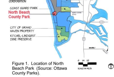
3
north, and North Shore Road to the southeast and east. This study area was chosen to include the
parabolic dune and the small wooded area between the dune and North Shore Road in the
direction that the dune might be moving.

2.3 What is a parabolic dune?
        The large dune in North Beach Park is a parabolic dune—a crescent-shaped dune
with the arms (also known as wings or horns) pointing upwind, i.e., towards Lake Michigan
(figures 2 and 3). Parabolic dunes are sometimes referred to as ‘blowouts’ or ‘blowout
dunes’ because they form when wind erosion enlarges a disturbance on an existing dune
surface, eventually producing a distinct erosional area (the trough) and a depositional lobe.
Wind accelerating through the trough enlarges the blowout, pushing the crest downwind and
elongating the arms. As the blowout grows, it modifies wind flow patterns, often directing
the flow along the blowout axis and accelerating the wind as it moves up the backslope. An
active parabolic dune migrates as sand, derived mostly from the lower backslope, is
transported across the upper backslope and deposited on the lee slope between the crest and
the slipface.
        The sand deposited at the top of the lee slope eventually destabilizes the slope,
causing sand to flow or slip downwards. The dune advances as the margin of the slipface
moves downwind, and the dune may override dunes or other obstacles in its path. Vegetation
can stabilize the parabolic dune by decreasing or halting sand movement on the dune.
        Sizes and shapes of parabolic dunes vary considerably. Parabolic dunes have heights
ranging from just a few meters to more than 100 meters, and lengths vary from several
meters to 1.5 km or more. Parabolic dunes on the east coast of Lake Michigan tend towards
the larger end of the size range. In P.J. Hoffmaster State Park, located 3 km north of North
Beach Park, the parabolic dunes have heights of 38 to 76 meters and lengths of 200 to 500+
meters (Bierma, Benthem et al. 2003). Parabolic dune shapes range from simple U-shaped
geometries to complex dunes with multiple lobes emerging from the original dune or smaller
blowouts developing within the dune (Trenhaile 1997). The current shape of a parabolic
dune may be the product of numerous cycles of erosion and deposition which can complete
or partially erase the original shape of the dune. Because local differences in wind, sand
supply, original topography and vegetation influence how a parabolic dune develops, even
adjacent dunes are not exactly alike (David, Wolfe et al. 1999). Stability and vegetation
cover vary between dunes and between different parts of the individual dunes.
        Lake Michigan coastal dunes have a distinctly seasonal pattern of change. Aeolian
processes are most effective during the late fall and winter when strong northwesterly winds
transport sand and vegetative protection of dune surfaces is reduced (van Dijk 2004).
Hansen et al. (in press) measured the activity of an active parabolic dune southeast of
Holland, Michigan. They found that the maximum amount of sand transport tended to occur
around the dune axis, no matter what the wind direction (Hansen, Arbogast et al. in press).
During the fall and winter, most deposition occurred on the upper and middle lee slope of the
dune as wind moved sand over the dune from the lake-facing blowout. Relatively little sand
reached the lower slopes, and the upper slopes oversteepened through the winter as snow and
ice cemented the sand grains in the deposit. During spring thaws, there was a net downslope
movement of sand and large amounts reached the bottom of the slope. By the end of May,
the net forward migration of the dune was measured at 1.6 m (Hansen, Arbogast et al. in
press). Very little sand was deposited between May and September.

                                               4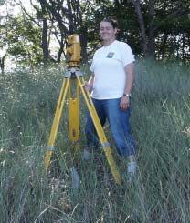
5
3.0 Methods
       Study methods include ground surveying to map dune topography and surface
characteristics, site observations and post measurements to assess dune activity, and a literature
review of dune management strategies. Each method used in this study is described below.

3.1 Surveying
        A Topcon GTS-4 electronic total station was used to survey points within the study area
for topography and mapping dune regions. Because of the size and vegetated state of the dune, a
number of total station locations were needed to cover the study area. Benchmarks were
established so that survey data from different days and station locations could be integrated.
Stable, long-term features such as large trees and concrete foundations of boardwalks were
chosen as benchmarks because they could be used in future surveys of the area. Benchmarks on
trees were marked with nails and flagging tape, and all benchmark locations were recorded for
future use (see Appendix A).
        The surveying was accomplished by a two-person team. After setting up the total station
at an appropriate location and orienting the total station to north (by means of compasses on
either side of the total station), one person operated the total station while the other person held a
rod with a prism at each survey point (figure 4). When the total station was aimed at the prism, it
provided information on the angles (vertical and horizontal) and distances (slope, horizontal, and
vertical) between the total station and the prism. The survey points adequately represent the
dune topography because a prism height of 2m was maintained throughout the study. Survey
points included topographic high points, low points and breaks in slope so that the topography of
the dune could be mapped. As well, the boundaries of bare sand areas and vegetated areas,
significant dune features, and human structures on the dune were surveyed so these areas and
features could be mapped.

  a.                                                  b.
Figure 4. Ground surveying was done with a) total station and b) prism.

                                                  6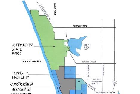
The survey data were entered into a Microsoft Excel spreadsheet. X, y and z coordinates
were calculated from the survey data, and the data were adjusted to a common frame of reference
because there were different station locations (see Appendix B). The corrected x, y, and z
coordinates were then pulled into RockWorks, a computer software mapping program. Symbols
were added to the data to identify the type of surface cover for each location, whether
geomorphic, vegetative, or human. Maps were then produced using the two-dimensional and
three-dimensional mapping techniques available in RockWorks. The software was also used to
calculate areas and distances on the map.

3.2 Assessing Dune Activity
        Observations of dune characteristics and surface conditions were used to assess the
general activity of the parabolic dune. We recorded and mapped indicators of different types of
dune activity, including erosion, deposition, and stability (table 1). The map showing major
areas of dune erosion and deposition was examined for trends in dune activity.

Type of Dune Activity       Possible Evidence
Erosion                     Windward slope areas with bare sand (no or limited vegetation)
                            Vertical or undercut slopes
                            Exposed roots
                            Toppled trees
                            Deflation hollows, troughs or channels on dune
Deposition                  No or limited organic litter on surface
                            No or limited herbaceous layer
                            Sand on top of organic litter
                            Sand partially burying shrubs or trees
                            Presence and health of species that need sand movement (eg Pitcher’s
                            Thistle or vigorous American beach grass)
Stability                   Undisturbed organic litter at surface
                            Presence of vegetation that requires stable environments (such as a
                            climax forest community)
Table 1. Indicators of different types of dune activity.

        Data from existing markers were used to calculate rates of parabolic dune advance. In
1997, Ottawa County park staff installed four wooden marker posts at the landward edge of the
parabolic dune slipface. With the ground level as base zero, one-foot vertical increments had
been marked on the posts with nails. The number of nails up the post indicated the same number
of feet above base zero: one nail indicated one foot, two nails indicated two feet, etc. Ottawa
County park staff recorded changes to the dune relative to the posts since their installation,
including distance of the slipface edge past the post and height of the slipface relative to the post
(figure 5). The post observations are reproduced in table 2. We made the summer 2004 post
measurements and used the earlier data provided by park staff to graph dune advance and
calculate the rates. From the calculated rates and measured distance between the current edge of
the dune and the road, we calculated how long it would take the dune to reach the road.

                                                  7
Figure 5. Diagram showing how dune changes are recorded relative to posts installed at the
edge of the dune slipface.
Measurement Date: 10/15/1997 9/20/1998 6/9/1999 5/10/2000 5/30/2003 7/13/2004
Distance (m) of dune edge beyond post:
Post 1 0 0 0.30 0.46 1.22 2.30
Post 2 0 0 0.30 0.61 3.66 post buried
Post 3 0 0 0.15 0.61 2.44 2.82
Post 4 0 0 0.15 0.15 1.83 2.65
Height (m) of dune slipface at post locations:
Post 1 0 0 0.25 0.36 0.76 1.21
Post 2 0 0 0.25 0.46 1.73 post buried
Post 3 0 0 0.03 0.46 1.52 1.84
Post 4 0 0 0.08 0.10 1.07 1.55
Length of measurement period: 0.9 yrs 0.7 yrs 0.9 yrs 3.0 yrs 1.1 yrs
Table 2. Measurements of dune position relative to 4 posts installed at the slipface edge in 1997.
83.3 Observing Human Activity
As field data were being
collected on the dune (surveying,
post measurements, etc.), we
recorded the number of people
climbing the dune and their
activities (figure 6). This was
done by simple tally as people
climbed the dune. Records of
their activities included method of
ascent, recreation on the dune,
and path of descent. Rough
estimates of number of people
using the dune per hour were
calculated from the recorded data. Figure 6. People observed from the crest of the dune.
3.4 Coastal Dune Management
We reviewed recent literature on coastal dunes and dune management techniques. The
most common management techniques were summarized for this report. With the characteristics
and activity of the parabolic dune in North Beach Park in mind, we developed several
recommendations for the Ottawa County Parks & Recreation Commission and Construction
Aggregates Corporation.
4.0 Results
4.1 Dune Topography
The field measurements and ground surveying of the North Beach Park dune occurred
during June, July, and August 2004. The dune was surveyed using a total of sixteen total station
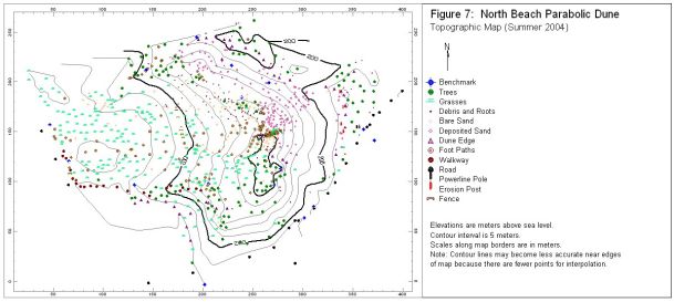
locations across the dune. The study included eighteen benchmarks (figure 7), with two to six
benchmarks used for each station location. Including the benchmarks, a total of 997 points were
measured along the dune surface in order to give a detailed coverage of the site. The survey area
covered the complete dune form from North Shore Estates Road on the west to North Shore
Road on the east. The north boundary of the survey area was the adjacent dune and the south
boundary was North Shore Road. Because of changes in slope angles and variations within the
dune area, more points were surveyed for the blowout (trough) of the dune than the arms or
slipface.
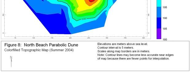
The parabolic dune at North Beach Park has an area of 64,750m2. The dune has a height
of 45m above Lake Michigan, with the highest point located at Benchmark 3 at the crest of the
dune (figure 8). The lowest location within the dune system, 183 m above sea level (a.s.l.), is in
the lower bowl near the south arm. The dune is 239 meters wide from the edge of the slipface on
the north arm to the edge of the slipface on the south arm. The dune has a length of 285 meters,
measured from the observation deck to the bottom of the dune slipface. The distance between
the parabolic dune and the nearest dune ridge to the east is approximately 35 meters.
910
11
4.2 Dune Regions
        The dune system can be identified by four main regions: an area with low vegetation,
forested dune surfaces, areas with bare sand, and dune surfaces with recent deposition (figure 9).

                                                12
Low vegetation exists where there is little to no disturbance or erosion in the dune blowout
(figure 10). Plants such as marram grass, flowering plants, shrubs, and other smaller plants
promote stabilization of the dune. The forested dune regions are generally located on the arms of
the parabolic dune (figure 11). These plant communities have taken a longer time to develop,
need stable surfaces to survive, and only major erosion will cause loss of vegetation.
Figure 10. Low vegetation in dune blowout, with forested south arm of dune in background.
Figure 11. Forested north arm of dune contrasts with the eroded area inside the blowout.
13The areas of bare sand represent the dune surface with the greatest amount of physical
erosion and human activity/disturbance. Bare sand areas include pathways through the trough of
the dune, large areas on the upper backslope of the dune, and areas on the crest of the dune. The
bare sand area on the upper backslope of the dune has an area of 4,678 m2. Logs, stumps, and
other tree debris in this area are indicators of erosion, possibly from the vegetated boundaries of
this area (see figure 11). Vertical scarps and undercut slopes are common around upper edges of
the exposed backslope (figure 12). Numerous exposed roots are evidence of erosion, and one
tree near the crest of the dune has nearly the entire root system exposed (figure 13).
Figure 12. Exposed roots and the steep slope
angle indicate erosion near the top of the dune.
Figure 13. The exposed roots of this tree at
the crest of the dune indicate where the dune
surface used to be.
14Recent deposition has been mapped on the slipface of the dune where wind-blown sand
or mass wasting deposits are visible. This area is vegetated with trees and some other plants but
does not have the leaf litter that is typical of slopes without deposition (figure 14). Some of the
trees and bushes have been partially buried by sand, including a maple tree whose trunk has been
completely buried (figure 15). Because of the evidence of widespread deposition, this area will
be referred to as the “active slipface” to distinguish it from stabilized slipface areas. The shortest
distance between the active slipface and North Shore Road is 12 meters. Other edges of the
active slipface are 20 to 30 meters away from the road, with the slipface edge angling towards
the ridge behind the dune. The road is approximately 20 meters east of that short ridge.
Figure 14. View down the
slipface from the dune
crest: note that there is no
leaf litter or herbaceous
vegetation, the small tree is
partially buried by sand,
and there are numerous
footprints.
F
Figure 15. The top of a maple tree, in full leaf, is visible in the dune slipface.
154.3 Dune Migration
From measurements of the leading edge of the dune relative to wooden posts, the rates of
dune movement were assessed over a seven-year period (table 3). By the summer of 2004, one
of the posts (Post 2) had been completely buried by the dune and could not be located. A
conservative estimate of the dune position relative to Post 2 in 2004 was used for the analysis.
Average dune advance between 1997 and 2004 at the posts was 3 meters. The average rate of
dune advance increased from 0 m/yr in 1997-8 to 0.25 m/yr in 2000 to 0.67 m/yr in 2004. Total
dune migration (from 1997 to 2004) was the greatest at Posts 2 and 3 and the lowest at Post 1.
However, between May 2003 and July 2004, the largest amount of dune advance occurred near
Post 1.
Measurement Date: 10/15/1997 9/20/1998 6/9/1999 5/10/2000 5/30/2003 7/13/2004
Difference (m) in dune edge positions between measurements:
Post 1 - 0 0.30 0.15 0.76 1.08
Post 2 - 0 0.30 0.30 3.05 0.67 *
Post 3 - 0 0.15 0.46 1.83 0.38
Post 4 - 0 0.15 0.00 1.68 0.82
Average rate in m/time interval 0 0.23 0.23 1.83 0.74
Time interval (years) 0.9 0.7 0.9 3.0 1.1
Average rate (m/yr) 0.00 0.33 0.25 0.61 0.67
Table 3. Dune position measurements and calculated rates of dune migration for North Beach
Park parabolic dune. *In 2004, Post 2 was completed buried; estimated value is based on rate of
dune migration from previous year.
164.4 Human Activity
The human presence on the North Beach Park dune was measured during nine days in the
summer of 2004 (table 4). During this time, an average of 24 people was found to use the dune
during a 4.5 hour interval. Rates of activity varied from the busiest day with 61 people observed
in almost six hours and the slowest day with no one observed in a little over three hours.
Human activities on the dune took many forms. The most popular activity was climbing
up the dune to the crest, using either the walkway or the path up the center of the dune. People
also hiked over the arms and slipface of the dune. Once they were on the dune, people
participated in many activities, including jumping off higher points into bare sand, sledding,
playing Frisbee in bare sand, climbing trees, tanning and picnicking. The dune was also used for
exercise with several people jogging up the center of the dune and back, or up the center of the
dune and down the slipface. The most common way for people to go down the dune was on the
center path through the blowout, although some people used the walkway. Many people went
down the dune by running down the bare sand path. Another popular way down the dune was a
route down the slipface into the woods, although most people climbed back up the slipface rather
than walking along the road back to the beach. The human presence on this dune is
considerable.
Observation # of # of Maximum
Day Period Hours People Temperature* Comments
6/16/2004 10:00am -3:30pm 5.5 29 27°C (81°F)
6/18/2004 9:15am-2:30pm 5.25 58 21°C (70°F)
6/21/2004 9:30am-12:45pm 3.25 0 18°C (65°F) Raining
6/22/2004 9:00am-noon 3 26 19°C (66°F)
6/23/2004 9:00am-1:00pm 4 10 19°C (67°F)
6/25/2004 9:30am-1:00pm 3.5 1 18°C (64°F)
6/29/2004 8:30am-1:00pm 4.5 15 23°C (74°F)
6/30/2004 9:45am-3:30pm 5.75 61 24°C (75°F)
7/9/2004 9:00am-3:00pm 6 14 20°C (68°F)
Average: 4.5 24 21°C (70°F)
Table 4. Log of human activity on North Beach dune on selected days during the summer of
2004. *Temperatures are reported for Muskegon, MI (Source: National Weather Service 2004).
175.0 Discussion
The large parabolic dune in North Beach Park is undergoing rapid geomorphologic
change. The spatial pattern of erosion and deposition areas indicates that sand is moving from
the large deflation area on the dune’s upper backslope, over the dune crest, and to the upper
slipface where the wind-blown sand is deposited. The deposited sand rolls or slides down to the
bottom of the slope, causing the leading edge of the dune to advance. On fall or winter days with
very strong winds and no foliage on the slipface vegetation, some of the wind-blown sand may
be deposited over the entire slipface and possibly into the woods beyond the dune. The large
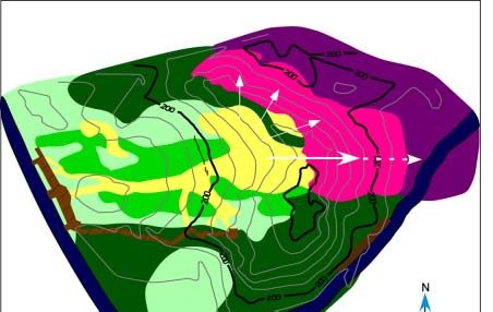
solid arrow in figure 16 shows the dominant direction of sand movement in the parabolic dune is
from west to east. The direction has been estimated from a number of factors: the high rates of
dune advance measured at Posts 1 and 2 are in this area, the slipface extends the furthest from
the dune crest in this direction (visible on the map), the topography of the dune crest has a trough
oriented in this direction through which sand can travel, and visual indicators of deposition are
greatest in this direction. Significant amounts of sand are also being moved over the north arm
of the parabolic dune (the smaller arrows in figure 16), where slipface advance is moving
towards an adjacent dune.
Movement of sand from west to east over the top of the dune is consistent with the
dominant westerly direction of winds in the area. Topographic steering by the parabolic dune, in
which winds from a wider range of directions (i.e., south and southwest winds or northwest and
north winds) are steered by the dune shape up the center of the dune, will also contribute to
moving sand towards the slipface in the direction of arrow 1. The location of the main erosional
area on the upper backslope of the dune is consistent with parabolic dune activity. Winds
accelerate as they move up dune slopes, and the highest wind speeds with the greatest erosion
potential can be expected near the top of the dune. In addition, the North Beach Park dune has a
relatively simple configuration without stands of trees or smaller dunes along the main trough to
slow down the wind.
During the summer study period, there was no indication that sand was coming into the
parabolic dune from other areas, such as the beach. Between the beach and the main trough of
the parabolic dune are the significant barriers of the parking lot, North Estates Road, a
boardwalk, and the mostly-vegetated lower backslope of the parabolic dune. During our study,
we noted that sand that had moved onto the asphalt parking lot was moved back to the beach as
part of the park maintenance.
Human activity appears to be a significant contributing factor to the activity of the
parabolic dune, particularly in accelerating erosion on the backslope, keeping the dune crest open
and moving sand downslope on the dune slipface. The repetitive use of the path through the
dune center for climbing and running has eliminated all the vegetation on that path. The location
and direction of the path correspond to the main axis of sand movement. With the present end of
the wooden walkway some distance from the top of the dune, many visitors are finding their own
ways to the crest. The multiple pathways contribute to widespread erosion, especially as people
chose some vulnerable areas for climbing. Most of the observed visitors chose to climb the final
distance through the main deflation area, rather than following an informal pathway along the
forested arm of the dune. A significant number of people walked along the scarps on the south
side of the deflation area, dislodging materials along those steeper slopes and in some cases
pulling on roots for support (figure 17).
1819
Figure 17. Park visitor walks from dune crest to upper observation deck along
         base of eroding scarp on south arm of dune.

        The numbers of observed visitors to the dune are consistent with amounts of people that
could cause significant damage to the dune. Studies on trampling damage suggest that the onset
of damage occurs in the range of 26 to 100 visitors per day (Nordstrom 2000). Although none of
our observation periods were longer than 6 hours in length, on 4 out of the 9 observation days we
recorded more than 26 people on the dune. Priskin (2003) states that plants in foredune and
primary dune areas (i.e., pioneering species) are more vulnerable to disturbance but better
adapted for recovery. Vegetation on stabilized dunes, particularly trees and shrubs, have poorer
recuperative abilities due to death by root exposure and damage when they are exposed to
disturbances such as trampling (Priskin 2003). Our limited observations suggest high rates of
human activities in the parabolic dune; a study recording numbers of visitors and activities over a
longer time period would be very valuable to future management.
        The activity of the parabolic dune poses a real threat to North Shore Road. In the main
direction of dune movement, the leading edge of the dune is 12 meters from the road at its
closest location (see the dashed arrow in figure 16). Based on the 1997-2004 average rate of
dune advance, 0.37 m/year, the leading edge of the dune will reach the road in approximately 32
years. If the most recent rate of dune advance is used, 0.67 m/year, the dune will reach the road
in approximately 18 years. These estimates may be too conservative, given the pattern of
increasing rates of dune advance since 1997. At this time, there are too few data points to
suggest whether the rate will continue to accelerate or is leveling off. Fortunately, the leading
edge of the dune is not yet at the side of the road, and there is a window of opportunity to prepare
and/or to attempt to slow down the dune migration by stabilizing parts of the dune.

                                                20
6.0 Coastal Dune Management
Dune management varies according to the characteristics of the dunes being managed and
the needs, goals and resources of the managers. The following discussion is not intended as a
how-to manual, but as a general description of common dune management techniques and their
usefulness under different conditions.
6.1 Mechanical shaping of the dune
Earth-moving equipment can be used to mechanically shape the dune, a process which
may involve removing material, adding material, or a combination of removal and addition to
reshape the dune.
6.1.1 Removing dune sand
Earthmoving equipment can be used to remove dune sand from undesirable locations.
This method is commonly used when buildings are constructed in dune environments, to
improve a view (usually so that the ocean or lake is visible from windows of residences), or to
remove wind-blown sand from a structure, road or yard. Removing dune material works best
with smaller dune features, such as foredunes or sand blowing into parking lots or across
roadways from a beach. The drawback of removing a foredune is that its coastal protection is
removed, and the structure needing the better view becomes more vulnerable to storm activity.
Removing wind-blown sand from parking lots and roadways does not affect the source of the
wind-blown sand, so the activity needs to be repeated and costs must be born as ongoing
maintenance. Sand removal is not recommended at the base of large dunes, because the removal
steepens the slope angle and increases the likelihood of mass movements (slides and flows) of
sand to fill in the same location.
6.1.2 Replenishing dune sand
A dune can be replenished by adding material to dune areas where the net movement of
sand has resulted in a loss to the internal system. Bulldozers can be used to move the sand when
the source of materials is close to the replenishment area. When the material source is more
distant, sediments may be transported through pipes as a slurry or trucked into the area before
being shaped by a bulldozer. This method is most often used where coastal dunes have been
removed by storm activity and the protection of a dune is needed for future storms. The newly-
placed material can be stabilized by other management techniques, such as sand fences or
vegetation planting, to increase the longevity of the feature. However, the natural process of
layering sand over time is excluded, producing an unnaturally shaped landform (Nordstrom
1994).
6.1.3 Reshaping the dune
Earth-moving equipment can also be used to reshape dunes by moving material from one
dune area to another. In cases where the dune is eroding too quickly, it is possible to return the
excess material on the slipface to the blowout. However, this will create problems with
encountering vegetation in the way, destabilization of the slipface slope, and cost efficiency. On
a parabolic dune, reshaping for stability may mean shaping the crest of the dune to remove the
blowout trough. There may be considerable difficulty in getting equipment up to the top of the
dune without damaging other areas of the dune. Reshaping has been used to reduce slope angles
to produce stable surfaces for planting (Ritchie and Gimingham 1989).
216.2 Surface stabilizers
Surface stabilization with chemicals, organic debris and materials, or inorganic materials
is a method used to prevent sand movement. The goal of these techniques is to immobilize
surface sediments for a certain period of time as a sand control measure or to stabilize the area
until a second management technique such as establishing vegetation can take hold. Planting
vegetation will be discussed as a separate management technique
6.2.1 Stabilizing the surface with chemicals
Chemical stabilizers stop sand movement by forming a protective coating over the
surface or creating cohesion between the surface sand grains. Some materials which have been
used as surface stabilizers are crude oils, asphalts, synthetic latex, polyvinyl, polymers,
hydrosilicates, and gelatine (Schiechtl 1980; Watson 1985). Stabilization with chemicals usually
has only a temporary effect, and the life-expectancy of the treatment is critical when the cost of
materials and application are considered (Watson 1985). Treatment life increases with the
thickness of the material, penetration into the surface (which can be enhanced by pressure
injection), and material resistance to breakdown over time or in response to natural conditions
(Watson 1985). Some crust-forming stabilizers (bitumen and tall oil) cannot endure frost, which
produces cracks that make the surface susceptible to wind erosion (Schiechtl 1980). Heavy or
frequent rainfalls also reduce the effectiveness of chemical stabilization. As a result, chemical
stabilizers have been used most effectively in arid regions where rainfall is infrequent and
stabilizing the surface with vegetation is difficult. Chemicals have also been deliberately used
for short-term sand control to stabilize sand surfaces until vegetation can take root. Not all
chemical stabilizers can be used with vegetation because some of them prevent or inhibit
germination and vegetation growth.
6.2.2 Organic materials to stabilize surface
Straw mats, twigs, branches, and other organic debris can be spread over the dune surface
to stabilize the surface or to encourage deposition. The organic materials have a twofold effect:
the materials prevent wind erosion of the sand surface and the increased surface roughness traps
wind-blown sand moving into the area. As the sand deposit grows, the organic materials will
biodegrade. This method has a low cost when local materials are used, such as woody debris
from other areas of the dune. Lighter materials such as straw and small branches need to be
staked down to prevent their removal by wind. Branches or wooden palings may also be planted
in the sand or debris plowed into the surface or partially buried to keep them in place. Surface
stabilization using biodegradable materials is often used in conjunction with planting dune
vegetation.
6.2.3 Armoring the surface with inorganic materials
Managers can reproduce desert pavements by armoring the sand surface with rocks or
other inorganic debris such as construction site waste and tires. The armoring materials need to
be heavy enough that they cannot be moved by the wind, and they act as a protective layer to
prevent wind erosion of the surface. If the surface of the armoring materials is smooth, sand
moving into the area may be transported across the pavement because sand transport is more
effective on solid surfaces than on loose sediments. In some desert regions, this aspect of sand
transport has been used for sand control: baffles have been set up to increase wind speeds over
roadways so that sand will cross to other side. If the armoring material is rough, the materials
22will trap moving sand in the same way that organic debris does. The difference is that the
materials will not biodegrade over time within the dune sand. In some areas, this is done
deliberately; for example in New Jersey where geomembranes were placed within nourished
dunes to make the core more resistant to wave attack during storms (Nordstrom, Jackson et al.
2002).
6.3 Sand fences
Sand fences can be used to trap wind-blown sand either to create dune features or to stop
sediment transport. Fences are used to 1) fill in gaps in dune ridges, 2) create new dunes, 3)
create dunes which will be ‘sacrificed’ to wave processes in order to protect more valuable
dunes, and 4) prevent inundation of cultural features that are landward of the dune (Nordstrom
2000). The fences reduce wind speed near the ground, thereby causing moving sand to be
deposited into a mound on the downwind side of the fence and reducing deposition further
downwind (Gares 1990). As the sand deposit grows behind and around the sand fence, the fence
loses its effectiveness in slowing down the wind. Subsequent fences are necessary if continued
sediment trapping and dune growth is desired. Fences made of biodegradable materials are often
left in the sand deposit to be fully buried; otherwise, fences can be removed and placed in a new
position on the dune. (This task becomes more difficult with greater amounts of burial.) For
longer term stability, the sand deposits can be planted with vegetation that will continue to trap
sand.
Various types and configurations of sand fences have been used to control sand
movement and build dunes. The effectiveness of sand accumulation and the characteristics of
the sand deposit are influenced by “fence porosity, height, inclination, scale of openings, shape
of openings, wind speed and direction, sand characteristics, separation distance between fences,
number of fence rows, and placement relative to existing topography (usually pre-existing
dunes)” (Nordstrom 2000). In the United States, many communities use a standard size fence
(figure 18) with wooden slats about 38 mm wide by 1.2 m high; these fences are also used to
control snow drift (Nordstrom 2000). The porosity of these fences are often reported as 50% but
Figure 18. This sand fence in North Beach Park is used to keep people off the dune vegetation.
23Nordstrom’s (2000) measurements in New Jersey showed that average porosity was closer to
65%. A porosity of 50% is a good target porosity: higher porosities diminish the accumulation
rate and very low porosities cause circulation patterns upwind and downwind of the fence that
may locally increase erosion. In the Netherlands, fences are constructed of branches or reed
stakes which are placed close together to form 1-2 meter high barriers. The highest rates of sand
accumulation occur when the sand fences are placed perpendicular to the dominant direction of
sand movement, although installing a fence in almost any direction will result in some sand
accumulation. Nordstrom (2000) notes that sand fences used for crowd control produce many
interesting dune shapes. Similarly, fences used to build dunes for shoreline protection can
produce dunes with unnatural shapes, sizes or placement in the coastal environment. When
multiple sand fences are used, spacing distances will affect the shape and location of the dune
that is formed. In areas where the primary goal is surface stabilization rather than dune building,
additional fences may be required downwind of the first fence to maintain the decrease in wind
speed.
6.4 Planting vegetation
Planting vegetation is an effective way to increase dune stability. Vegetation plays two
roles in surface stability: root networks hold the sand in place and the stems, leaves and blades
of grass slow down the wind near the ground, thereby decreasing surface erosion and trapping
sediments. Planting vegetation on dunes includes afforestation, planting non-native species for
various reasons, and planting native species well-adapted to the dune environment.
6.4.1 Afforestation
Afforestation (foresting dune areas) has a long history of use as method of stabilizing the
shifting sand on dunes. Most of the plantings occurred in North America and Europe between
1920 and 1960, although the method dates back to well before 1900 and continues to this day. In
1989, Doody estimated that nearly 14% of Britain’s dune areas (8000 hectares) had been
afforested. Often the species used were conifers (pine and spruce) and plantations of various
sizes remain on coastal dunes to this day. When sand dunes are planted with conifers, nearly
total destruction of the native flora and fauna occurs within a few years because the trees
progressively shade vegetation and deposit relatively inert needles on the ground (Doody 1989).
6.4.2 Planting with non-native species
Dune areas may be planted with non-native species for a variety of reasons. In areas
where speed of stabilization, rather than restoration or conservation is the motivating factor,
quick results can be obtained by putting down a layer of topsoil, seeding it with a quick-growing
grass mix and applying fertilizer (Ritchie and Gimingham 1989). In the Scottish project that
Ritchie and Gimingham (1989) describe, the area was stabilized with a light spraying of bitumen
which also helped to retain moisture. In the years after the sown grasses were established, native
species were gradually re-established from the surrounding area. The vegetation gradually
blended in visually fairly well with their surroundings, although the restored area can still be
identified by the lack of Ammophila (Ritchie and Gimingham 1989). Exotic species are
sometimes planted by coastal homeowners who see the dunes on their property as an extension
of their landscaping. There has also been a long tradition of coastal managers introducing
species that have been successful in stabilizing dunes elsewhere in the world. One such example
is Ammophila arenaria (European beach grass) which was introduced to the west coast of the
24United States along with coastal areas in Africa and Australia. In the United States, the
European beach grass outcompeted the American beach grass (Ammophila breviligulata) and has
changed the shape of coastal foredunes along the west coast because of the different
characteristics of the grass (Wiedemann and Pickart 1996).
6.4.3 Planting with native species such as Ammophila breviligulata
Some advantages of planting dunes with native species are that dunes become a more
naturally-functioning system (Conway and Nordstrom 2003), the plants are well-adapted to dune
conditions and the vegetation may be readily available locally. For example, Ammophila
breviligulata (commonly known as American beach grass or marram grass) is a pioneering dune
plant that thrives in areas of active sand movement and deposition. The beach grass is naturally
found as a dune builder because of its abilities to tolerate hot, dry sand conditions, trap moving
sand, send shoots up through new sand deposits and spread by means of horizontal rhizomes.
Planting beach grass is a labor-intensive process, often accomplished by volunteers, in which
individual shoots complete with leaves and a short length of vertical rhizome with roots are
transplanted into the desired area. Plants that originate from mobile, rather than stable, dune
areas may improve the success of the planting (Nordstrom 2000). Since the beach grass is well-
adapted to sand burial, the plants will do better if they are placed in areas of active deposition
rather than erosion (Nordstrom 2000). Nordstrom et al. (2002) found that sand accumulations at
fences created optimum conditions for the growth of Ammophila. Ritchie and Gimingham
(1989: 238) report on an area where “the surface was thatched with a combination of Hessian
netting and coniferous branches to promote sand accretion”.
6.5 Managing human activities
In dune areas where erosion and surface instability have anthropogenic causes, dune
management must include a component of managing human activities. Other management
techniques, such as planting vegetation, will not be successful if people continue their
recreational activities in the problem areas. On the other hand, some dune areas may recover
naturally over time if the pressures of human use are taken away. Managing human activities
can range from banning all activities to carefully-controlled access to dune areas, but all plans
that involve changing human behavior must include careful communication to the stakeholders
to be successful.
6.5.1 Keeping people away from sensitive areas
Where dune erosion is partially or entirely caused by the human-induced stresses on dune
slopes and vegetation, restricting access to dune areas removes the stress and permits natural
dune recovery or managed dune restoration. In some cases, an entire dune system may need to
be placed off limits to human activities, particularly where problems are severe or dune visitors
are unwilling to change patterns of activity. In many cases, visitors are allowed access to the
dunes but kept away from particularly sensitive areas or certain recreational activities that place
the highest stresses on vegetation and dune slopes. Controlling access to dunes can take a
number of forms. Sensitive areas can be fenced off to exclude visitors. Choices of fencing types
include sand fencing which has an added component of reducing sand movement or other barrier
fences which permit sand movement across area boundaries but discourage human movement.
Some management plans call for careful planning of access paths to avoid excessive trampling of
vegetation (Tzatzanis, Wrbka et al. 2003). Managers can also regulate the number of visitors to
25the dune. Although this step may be necessary for the health of the dune, it is often a sensitive
issue for stakeholders (Tzatzanis, Wrbka et al. 2003). Passive means, such as limiting
infrastructure like restrooms and other facilities, can be successful in keeping people away from
distant locations. Passive means are less effective in small, easily accessible areas. Management
strategies also include leaflets, signs, and patrolling the managed area (Williams and Davies
2001).
6.5.2 Elevated boardwalks
An elevated boardwalk is a form of controlled access that deserves special attention.
Elevated boardwalks allow for natural dune processes and give dune access to potentially large
audiences while managing the stresses of human activities on dune surfaces (figure 19). The
elevation of the pathways above the dune surface permits natural movement of sand and
vegetation past the structure (Conway and Nordstrom 2003). As a result, the structures do not
need to interrupt the natural dynamism of dune areas.
Figure 19. Wooden stairs and observation decks along the south arm of the
North Beach Park parabolic dune.
6.5.3 Education
Public education is an essential component of any dune management plan that involves
keeping people away from specific areas or restricting the range of permissible activities.
Without the participation of the people visiting the dune area, attempts to decrease human
impacts on dune areas will be unsuccessful. However, public support in a coastal management
context may be difficult to obtain because “the public is frequently unaware of the damage they
26can create” (Nordstrom and Mitteager 2001). Unless the public perceives that there are
compelling reasons for them to change their behavior, people are likely to continue the activities
they have enjoyed in the past.
6.6 Managing dunes as naturally dynamic landforms
For some dunes, the management priority is conserving or restoring dune areas as natural
environments, i.e, with natural physical processes and ecological characteristics. Coastal dunes
are valuable in many different ways, and other possible management priorities for dunes include
coastal protection, protecting cultural features, tourism, agriculture, residential uses, mineral
extraction, etc. Some entities like national and state parks have specific mandates to maintain
the natural features of the environments within their boundaries. Private owners, non-profit
organizations, and local governments may also make managing dunes as naturally-dynamic
landforms a priority. In a natural dune system, overstabilization can be as much of a problem as
erosion—it leads to a loss of biodiversity (Shanmugam and Barnsley 2002) and dampens the
physical dynamics of the landforms. Several management approaches are based on maintaining
the physical and ecological dynamics of coastal dune systems.
6.6.1 No or limited interference with dune activities
Where natural processes are paramount, interference with dune behavior may be
forbidden or severely restricted. No interference with dune activities may result in a policy of
abandoning structures that are in the way of dune movement, such as boardwalks, roadways, and
buildings. Cultural features can also be relocated to less risky areas. These management
strategies may work best when there are few cultural features in the vicinity of dune activity,
either because building is not permitted in the dune area or the remote location of the dunes
naturally limits development. Stakeholders may also practice a policy of limited dune
interactions, such as removing wind-blown sand from parking lots, boardwalks and near
buildings without seeking to change the dune behavior supplying the sand. As long as the dune
activity continues, the maintenance activities must be repeated to keep pace with the dune. Some
structures may eventually be abandoned, particularly where large dunes are actively migrating
towards the structures.
6.6.2 Limited stabilization
A policy of limited stabilization has coastal dune managers working to stabilize critical
areas while leaving other areas as natural as possible. Critical areas could be those where dune
activity threatens valued structures or locations where the coastal protection afforded by dunes is
required. Managers may use surface stabilization techniques, fences, planting vegetation, and
managing human activities to control sediment movement in undesirable locations. Preferred
methods are those which maintain the natural aspects of the dune system, such as using
biodegradable and local sources of materials for surface stabilization, temporary or
biodegradable sand fencing, native species for planting and less obtrusive methods of controlling
human activities such as pathways instead of fences.
6.6.3 Remobilizing dunes
Some dunes are deliberately destabilized (remobilized) to reinstate a naturally-dynamic
dune system or to promote growth conditions for certain species. Williams and Davis (2001:
145) state that “actions which ensure permanent stability, particularly through fixed vegetation,
27You can also read