Geophysical Survey of a Proposed Development at Newtown, Marsh Road, Drogheda, Co. Louth
←
→
Page content transcription
If your browser does not render page correctly, please read the page content below
Geophysical Survey of a Proposed Development
    at Newtown, Marsh Road, Drogheda,
                  Co. Louth

                     Client

             J. Murphy Developments,
               Bryanstown Centre,
                    Drogheda
                   Co. Louth

                                               ITM: 710451, 775062

                                       Planning Ref.: ABP-302215-18

                                              Licence No.: 19R0005

                                    Donald Murphy & Robert Breen

                                                  14th January 2019

                                                   ACSU Ref.: 1837
PROJECT DETAILS

Project                        Geophysical Survey of a Proposed Development at Newtown, Marsh Road,
                               Drogheda, Co. Louth

Report Type                    Geophysical Survey

Archaeologist                  Donald Murphy and Robert Breen

Client                         J. Murphy Developments, Bryanstown Centre, Drogheda, Co. Louth

Site                           Newtown, Marsh Road, Drogheda, Co. Louth

Townland                       Newtown

ITM Ref.                       710451, 775062

Planning Ref. No.              ABP-302215-18

RMP No.                        N/A

Detection Device Licence No.   19R0005

Report Date                    14th January 2019

ACSU Ref.                      1837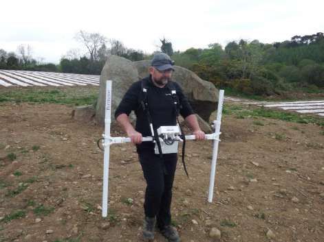
Newtown, Marsh Road, Drogheda, Co. Louth   Archaeological Consultancy Services Unit

Page | ii
Newtown, Marsh Road, Drogheda, Co. Louth Archaeological Consultancy Services Unit
NON-TECHNICAL SUMMARY
This report details the results of a Geophysical Survey carried out on behalf of J. Murphy Developments, Bryanstown Centre, Drogheda,
Co. Louth, on a proposed development at Newtown, Marsh Road, Drogheda, Co. Louth (ITM 710451, 775062). The geophysical survey
and subsequent testing are being carried out in response to a request for same from the National Monuments Service on foot of a
Strategic Housing Development (SHD) application (Ref: ABP-302215-18). The site does not contain any Recorded Monuments.
The geophysical survey was conducted by Donald Murphy and Robert Breen of Archaeological Consultancy Services Unit (ACSU) from
2 to 9 January 2019 under license 19R0005. A full detailed gradiometer survey was undertaken throughout the application area (Fields
1 and 2) using a Bartington GRAD 601-2 dual sensor fluxgate gradiometer system. Detailed survey was conducted with a sample interval
of 0.25m and a traverse interval of 1m for all the survey areas within the site of the proposed development with variations in the magnetic
field (between -100nT to +107.834nT). Both fields serve agricultural purposes and have been ploughed relatively recently. The northern
half of both fields decline in gradient towards the R150 road, which runs perpendicular to the site.
Field 1
The southern end of Field 1 produced an E–W band of disturbed results, likely as a result of the power lines that cross over the site.
These disturbances are the result of high amounts of magnetic variations which are evidently focused to this lower half of Field 1.
A large sub-oval band of magnetic disturbance was identified in the eastern portion of the field and is likely the result of underlying
geology or resting ground water. This will be investigated further in the testing phase of the development.
A number of curvilinear anomalies were identified in the west and northern portion of the field although none of these have produced
results that are strong enough to confirm their archaeological potential with any certainty. Possibilities for such anomalies may be small
enclosures, dwellings, agricultural scars such as plough marks, or simply variations in the natural subsoil.
Isolated anomalies, such as those identified towards the middle of the field, may represent features of archaeological potential such as
pits, spreads, or kilns. They may, however, also represent ferrous anomalies within the topsoil, as a result of agricultural debris from
farming activities.
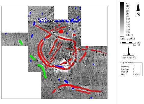
A potential circular anomaly was identified towards the north-eastern portion of the field and may represent a small enclosure.
Field 2
As in Field 1, the southern half of Field 2 also produced a number of magnetic anomalies most likely associated with the overhead
powerlines. These will be investigated during the testing phase of the project to confirm their nature.
A circular enclosure of archaeological importance has been identified along the eastern boundary of Field 2. This enclosure measures
c. 30m in diameter and appears to feature an internal structure, possibly a house site or animal pen. The nature and depth of this
enclosure will be fully investigated during the testing phase of the development.
A number of magnetic disturbances were also identified directly west of this enclosure site and may represent smaller features of
archaeological significance, such as refuse pits, post-holes, kilns, etc. A faint N–S linear anomaly identified among these features may
represent the line of an historic boundary, a field drain, or a plough mark.
Page | iiiNewtown, Marsh Road, Drogheda, Co. Louth Archaeological Consultancy Services Unit A number of larger anomalies were identified scattered towards the northern end of Field 2, where it begins to slope downwards towards the R150. These may represent ferrous anomalies in the topsoil, larger areas of refuse, burning or agricultural debris. The nature of these will also be investigated during the testing phase of the project. It is therefore recommended that targeted archaeological assessment in the form of test trenching be carried out in order to assess the nature and extent of these identified features, in particular the nature of the enclosure identified in Field 2. A large number of the stronger magnetic anomalies identified elsewhere will also be tested in order to ascertain their archaeological significance. Page | iv
Newtown, Marsh Road, Drogheda, Co. Louth                                                                                                  Archaeological Consultancy Services Unit

                                                                                             Contents
1. INTRODUCTION ................................................................................................................................................................................... 1
2. METHODOLOGY................................................................................................................................................................................... 1
3. THE DEVELOPMENT............................................................................................................................................................................ 1
    3.1 Proposal .......................................................................................................................................................................................... 1
    3.2 Archaeological Requirements.......................................................................................................................................................... 1
4. SURVEY OBJECTIVES ......................................................................................................................................................................... 1
5. SOILS, GEOLOGY & TOPOGRAPHY................................................................................................................................................... 1
6. ARCHAEOLOGICAL ASSESSMENT .................................................................................................................................................... 2
    6.1 Archaeological & Historical Background.......................................................................................................................................... 2
    6.2 Recorded Monuments ..................................................................................................................................................................... 7
    6.3 Previous Excavations ...................................................................................................................................................................... 9
    6.4 Cartographic Evidence .................................................................................................................................................................. 15
    6.5 Aerial Photography ........................................................................................................................................................................ 16
    6.6 National Inventory of Archaeological Heritage (NIAH) and Protected Structures .......................................................................... 16
    6.7 Field Survey................................................................................................................................................................................... 17
7. METHOD OF DATA INTERPRETATION ............................................................................................................................................ 17
8. SURVEY RESULTS............................................................................................................................................................................. 17
9. CONCLUSIONS................................................................................................................................................................................... 18
10. REFERENCES .................................................................................................................................................................................. 19
Appendix 1 - Summary Technical Information & Glossary of Terms ....................................................................................................... 22

List of Figures

Figure 1: Location of site

Figure 2: Location of site and nearby Recorded Monuments

Figure 3: Extract from Down survey (1654–56), showing approximate location of site

Figure 4: Extract from first edition OS 6-inch map (1835), showing location of site

Figure 5: Extract from 25-inch OS map (1907–9), showing location of site

Figure 6: Details of proposed development, showing geophysical survey areas (in pink)

Figure 7: Geophysical survey results (grey scale image)

Figure 8: Interpretation of geophysical survey, Field 1

Figure 9: Interpretation of geophysical survey, Field 2

                                                                                                                                                                                                Page | v
Newtown, Marsh Road, Drogheda, Co. Louth Archaeological Consultancy Services Unit Page | vi
Newtown, Marsh Road, Drogheda, Co. Louth                                                   Archaeological Consultancy Services Unit

1. INTRODUCTION
This report details the results of a Geophysical Survey carried out on behalf of J. Murphy Developments, Bryanstown Centre, Drogheda,
Co. Louth, on a proposed development at Newtown, Marsh Road, Drogheda, Co. Louth (ITM 710451, 775062; Figures 1–2). The
geophysical survey and subsequent testing are being carried out in response to a request for same from the National Monuments
Service on foot of a Strategic Housing Development (SHD) application (Ref: ABP-302215-18). The site does not contain any Recorded
Monuments.

The geophysical survey was conducted by Donald Murphy and Robert Breen of Archaeological Consultancy Services Unit (ACSU) from
2 to 9 January 2019 under license 19R0005. Fields 1 and 2 serve agricultural purposes and have been ploughed relatively recently. The
northern half of both fields slope significantly towards the R150 road and the River Boyne to the north.

2. METHODOLOGY
A full detailed gradiometer survey was undertaken throughout the application area (Fields 1 and 2; see Figure 6) using a Bartington
GRAD 601-2 dual sensor fluxgate gradiometer system. Detailed survey was conducted with a sample interval of 0.25m and a traverse
interval of 1m for all the survey areas within the site of the proposed development with variations in the magnetic field between (-100nT
to +107.834nT).

3. THE DEVELOPMENT
3.1 Proposal

Planning permission is currently being sought for a residential development at Newtown, Marsh Road, Drogheda, Co. Louth. The
proposed development is classed as a Strategic Housing Development (Ref. No ABP-302215-18). and a pre-SHD consultation resulted
in the request for an archaeological assessment.

3.2 Archaeological Requirements

The geophysical survey and subsequent testing are being carried out in response to a request for same from the National Monuments
Service on foot of a Strategic Housing Development (SHD) application (Ref: ABP-302215-18).

4. SURVEY OBJECTIVES
The purpose of this geophysical survey is to establish the presence of any archaeological features within this site, and to inform a
program of test trenching to be carried out across the development area.

5. SOILS, GEOLOGY & TOPOGRAPHY
The overall landscape of the Boyne Valley area has developed upon a geological base of rock formation formed by the folding and
development of the Caledonian phase of mountain building. The physical landscape we associate with the Boyne Valley area today has,

                                                                                                                                       1
Newtown, Marsh Road, Drogheda, Co. Louth Archaeological Consultancy Services Unit
however, been largely modelled by the blanket covering of glacial deposits during the last Ice Age. Lower Palaeozoic sedimentary slates
are the oldest rock type within the Boyne landscape. The lower Palaeozoic slates form two ridges located to the east and west on the
northern edge of the valley. Located to the north of the valley is carboniferous limestone. Stratigraphically, above the lower Palaeozoic
rock formations are carboniferous sedimentary rock formations. The lower Boyne Valley landscape is built upon this carboniferous
syncline, which is aligned on a northeast–southwest axis. This syncline consists of Namurian shale and sandstone deposits (Stout
2002).
The undulating landscape of the Boyne Valley has been moulded by glacial movement and deposition. It appears that during the last
Ice Age two glaciers would have influenced the development of the landscape. One formed in the north central midlands and the other
formed in the Irish Sea basin. It would appear that a large ice sheet developed somewhere in the northwest and in the centre of Northern
Ireland and that this moved over the Boyne Valley and the Drogheda area in a northwest–southeast direction. The Boyne Valley
landscape contains frequent deposits of glacial tills, gravels and silts (Stout 2002).
6. ARCHAEOLOGICAL ASSESSMENT
6.1 Archaeological & Historical Background
The earliest evidence for human presence in the Boyne Valley was found by archaeologists working at Newgrange and Knowth, where
stone tools associated with the Mesolithic were discovered, such as a broad blade or Bann flake from Newgrange (Stout 2002) and two
unusual ‘butt-trimmed forms’ from Knowth (Warren & Little 2017). If we consider the landscape of the Boyne Valley and compare it to
the pattern of currently-known Mesolithic sites in Ireland, the Boyne Valley has all the suitable characteristics to suggest a possible
location for Mesolithic activity. There is every reason to believe that there may have been a sizeable Mesolithic community within the
Boyne Valley area.
In recent years, a number of development-led excavations have located evidence of Early Neolithic activity within the surrounding
landscape of the Boyne Valley, dating to approximately 4000 BC. Early Neolithic settlers may have been drawn to the landscape of the
Boyne Valley because of the rich fertile soil and the river itself, which would have provided food and a method of communication. Early
Neolithic settlement patterns appear to form an impression of scattered individual farmsteads, each perhaps containing one extended
family. The Middle and Later Neolithic farming communities created a longer lasting impression on the landscape of the Boyne Valley.
Although they probably differed very little in their daily activities to the Early Neolithic population, it is possible that the distribution density
of settlements became larger and that the size of the population also grew. The lasting remainders of this period’s activity are, however,
the megalithic tombs located within the Boyne Valley landscape, centred around the three mega mounds of Newgrange, Knowth and
Dowth.
The end of the Neolithic and the beginning of the Bronze Age (2500–700 BC) would have seen the first appearance of metal working
within the landscape of the Boyne Valley. The megalithic tombs were being replaced by new types of monument (standing stones, timber
circles and henges) as different and diverse burial practices were developed. The landscape of the Boyne Valley would have seen
organised into field systems, which was accompanied by large-scale deforestation and a growth of the human population. Generally,
from the archaeological evidence found in the Boyne area, settlement patterns still appeared to be dispersed.
2Newtown, Marsh Road, Drogheda, Co. Louth Archaeological Consultancy Services Unit
During the Early Medieval period (c. AD 400–1100), rural settlement patterns were dominated by the presence of protected enclosed
farmsteads (ringforts), many of which are still traceable in the fields around the Boyne landscape today. Unfortunately, most have been
levelled and appear only as cropmarks on aerial photographs. A feature often associated with ringforts is the souterrain. These
underground passageways are usually built of dry stone and are sometimes found apparently independent of any enclosure. They may
have been used as places of refuge and possibly also for storage. In the Early Medieval period, the lower Boyne Valley formed part of
the kingdom of Brega, a territory that comprised much of the present county of Meath and north County Dublin. In AD 688, the territory
was split into two kingdoms: Northern Brega and Southern Brega.
Medieval Town of Drogheda
The medieval town of Drogheda was established in the 12th century as a distinct plantation town. In 1172, the tithes of land in the
modern counties of Meath, Westmeath, and parts of Longford and Offaly, together with lands in Dublin, were granted by Henry II to
Hugh de Lacy’s favoured house of Llanthony, situated on his estates in the valley of Ewyas in Wales. The establishment of two urban
parishes in 1186, and the importation of clergy to fill them, shows that Drogheda was being considered as a town site in the 1180s
(Bradley 1978). This would indicate that de Lacy made a decision to establish a town and therefore Drogheda did not develop organically.
The earliest surviving archaeological feature from this period is the Millmount motte, probably established by de Lacy before 1186 (Orpen
1911–20). He also seems to have been instrumental in setting up the parish churches of St Mary and St Peter, and this connection
shows him to be founder of the town on both sides of the River Boyne. The earliest charter is from 1194 and the offer of an internationally
recognised set of burgess rights emphasises the notion that colonists were being sought out. The walled area of medieval Drogheda
enclosed 113 acres, making it one of the largest walled towns in medieval Ireland (Bradley 1978).
Streets and Street Pattern
On the north side of the River Boyne, the plan of the medieval town of Drogheda appears to have survived almost completely intact into
modern times. The street plan forms a chequered pattern made by four pairs of streets running parallel to the river: Dyer Street and
Bessexwell Lane, West Street and Laurence Street, Fair Street and William Street, and finally Rope Walk and Upper Magdalen Street.
These streets are intersected by one main north–south route, Shop Street and Peter’s Street. They are also intersected by a series of
cross streets, of which Scholes Lane, Bolton Street, Stockwell Lane, Duke Street, Patrickswell Lane, Dominick Street, Mayoralty Street,
and Freeschool Lane are the most obvious examples. West Street is the broadest of the streets and it is evident that it was intended to
function as the main market place on the north side of the river.
The earliest reference to a street on the north side of the river is to Bothe (Shop) Street, mentioned in 1214. The name is derived from
the booths or shops that would have been found along this street. Towards the end of the 13th century the Llanthony canons were
receiving dues from a placea (plot) on the west side of Shop Street, perhaps to be identified with the plot held by the Llanthony canons
in 1355 (Bradley 1978).
The names of tenants for six plots on the east of Shop Street and five on the west are known during the 14th century, some of which
can be located exactly. On the south side of the junction between Batchelor’s Lane and Shop Street (where the open area in front of the
Augustinian friary lies) stood two Preston properties, to the south of which lay a tenement of le Boweneys and next to that, one belonging
to the Cosyns. Unfortunately, all traces of these were removed during the construction of the present friary. On the south side of the
junction with Bessexwell Lane lay another Preston property, next to which on the south was another belonging to le Boweneys. The
Prestons also held a house across from this, on the south side of the junction with Dyer Street, with the Llantony canons directly to the
south of them. These latter plots still survive (Bradley 1978).
3Newtown, Marsh Road, Drogheda, Co. Louth Archaeological Consultancy Services Unit
The Tholsel (an important public building) stood at the northwest end of Shop Street and the tenement of the parish church of St Mary,
mentioned in the extent of 1381, probably lay to the south of it, since the Prestons held the property on the west. There were also cellars
beneath the Tholsel, which were held by the Llanthony canons of St Mary’s. The Tholsel was occasionally referred to as the Guildhill. It
is shown on Newcomen’s plan as a tower house.
The change in name from East Street to St Laurence Street seems to have occurred about 1350, but the existence of the street may be
inferred from a charter of c.1206 mentioning the East Gate of the town. The street is not specifically named until the middle of the 13th
century when both stone and timber houses are mentioned there. A plot belonging to the Hospital of St John the Baptist, Dublin, is
referred to in 1298 as located along St Laurence Street and the names of nine tenants on the north side of the street and of eleven on
the south side survive from the 14th century. Only one of these can be tentatively identified – the plot of John FitzRobert, which would
appear to have been the final plot on the south side of the street and separated from the town wall by the lane leading to St Elena’s well.
The house of John Jordan is mentioned in 1396 and was perhaps connected with the clothier of the same name two generations before.
Two plots are referred to in the 15th century, of which that belonging to Joneta Swayne on the west side of Freeschool (Frumboldes)
Lane may still be identified. Frobolles Inn also stood in this street. Indeed, in view of the similarity between the names it may have been
located on the east end of Frumboldes Lane. There is also the possibility that the ‘particularly skilled goldsmith’ who repaired the cross
of Michael Tregury, archbishop of Dublin, had his workshop in this area. All of the medieval burgage plots along Laurence Street are of
a long narrow nature, except where they form the junction with Shop Street and Peter’s Street (Bradley 1978).
Peter’s Street, known as Great North Street, is first mentioned in 1331. The Prestons held four properties here during the mid-14th
century and the house of St Mary d’Urso had at least one property (Bradley 1978).
On the south side of the River Boyne, much of the original street pattern of Drogheda has been changed and interfered with. Only by
studying the maps of Newcomen and Ravell can the original street pattern be revealed. Barracks Street and Mary Street are post-
medieval additions. The original plan was composed of two north–south streets, Pitcher Hill and Cornmarket Hill, and one east–west
route, James Street and John Street. Curry’s Hill ran immediately inside the east wall and Newcomen’s survey indicates that a road ran
westwards behind John Street to the Butter Gate.
Archaeological Background of Nearby Townlands
A number of recent excavations in the vicinity of Colp village to the east have shown the area was an important Early Medieval centre
(Gowen 1989; Clarke & Murphy 2001; O’Hara 2008), while also exposing a largely unrecognised prehistoric heritage, particularly a
hidden Bronze Age landscape (Clarke 2001; Clarke & Murphy 2001; O’Hara 2003a, 2003b). Bronze Age activity was recorded at a
number of locations in the townland of Colp West during 2001 and 2003. A total of four disturbed burnt mounds or fulachtaí fia were
excavated, three of which were radiocarbon dated to the mid-third millennium BC (2585–2205 BC, 2470–2120 BC, 2580–2200 BC;
Clarke 2001; O’Hara 2003b), with a fourth dated to the mid-first millennium BC (780–390 BC; Clarke 2001). A disturbed burnt mound
(ME021:016) located in the townland of Colp West, adjacent to the site under discussion, joins other excavated Bronze Age features in
that townland, including a D-shaped enclosure (1520–1310 BC), a circular structure (1428–1046 BC) and a linear ditch that may have
functioned as a boundary feature that was potentially still visible in the Early Medieval period, as enclosures of that date appeared to
avoid it (Clarke & Murphy 2001). A post-built circular structure from the period 1020–790 BC (O’Hara 2003a) also provides evidence for
unenclosed Late Bronze Age settlement in the area, possibly contemporary with some of the burnt mound sites noted above (Clarke
4Newtown, Marsh Road, Drogheda, Co. Louth Archaeological Consultancy Services Unit
2001). Other features, primarily isolated pits and post-holes, were identified across the townland and dated broadly from the tenth to the
third centuries BC (Clarke & Murphy 2001).
Various Iron Age features were also recorded in Colp West, predominantly cereal-drying kilns and pits but also a circular structure (50
BC–AD 210) and a semi-circular enclosure (Clarke & Murphy 2001). The nature and extent of Iron Age settlement around Colp remains
unclear however. Early Medieval historian, Thomas Charles-Edwards (2000), has suggested a Roman trading settlement may have
been located in the area but there is as yet no concrete evidence for this. It is plausible, however, given the prominence of the Boyne
River and its navigability inland. The current understanding, albeit limited, of a site at Drumanagh, Co. Dublin, suggests it was a Roman
trading colony, or emporium, during the second century AD (Raftery 1994). Contemporary Roman accounts highlight intercourse across
the Irish Sea in the early centuries AD; Tacitus recorded that Agricola, the Roman governor of Britain (AD 78–84), had acquired
knowledge of the approaches and harbours of the east coast of the island from traders and merchants. Inbher Colpdaí, the port of Colp,
is mentioned in the 8th-century AD text, the Lives of St Patrick, as the place where Patrick disembarked before making his way to
confront King Loiguire at Tara. The area also formed the setting for an earlier myth involving the legendary Sons of Mil, one of whom,
Colpa, reputedly drowned at the mouth of the Boyne and was buried locally, reputedly within at a flat-topped mound in Colp East (ME021-
012007) known as Rath Colpa, which may be an Early Medieval raised rath.
The archaeological evidence of a curving field boundary suggesting a circular enclosure, as well as a decorated cross head and base,
suggest an Early Medieval monastic site existed at Colp (Bradley 1985). This ecclesiastical settlement may have been affiliated with a
bishop, St Aitheachain (or Aithcain), who is listed in the late 8th-century Martyrology of Tallaght but otherwise unknown. An
unprovenanced church site, Cluainaithcain, may bear this saints name (though this was disputed by Lanigan (1829), and the text in
which it occurs, the Calendar of Cashel, was probably complied in the 12th century AD. Colp was well positioned to be among the first
ecclesiastical sites to develop during the initial structured Christian mission following the dispatch of Palladius ‘to the Irish believing in
Christ’, by Pope Celestine in AD 431, to safeguard the orthodoxy of existing Irish Christians and provide active leadership in the
conversion of the island (Charles-Edwards 2000). Orthodox bishops, Palladius, Auxilius, Isernius, and perhaps Secundinus, were sent
from Gaul and seem to have been most active along the east coast where they were actively ministering and proselytising, a generation
or so before the Patrician mission. Secundinus is accredited with establishing a cell at Dunshaughlin, Co. Meath, and his obit was
recorded in the mid-5th century at this church (Hughes 1966; de Paor 1993). Dunshaughlin would later develop as a monastery in the
7th century, but the relationship between the early and later site is not clear. Perhaps a similar model can be applied to Colp, and the
early foundation may not have been extant when the monastic settlement was operating there in the 8th or 9th centuries AD.
A substantial cemetery (ME021-011001) and an enclosure (ME021-011002) were partially excavated in Colp West in 1988, where the
remains of over 100 individuals were buried over several generations. The presence of B-ware and E-ware pottery suggested settlement
from at least the 5th to 7th centuries (Gowen 1989). In 2001, an extensive Early Medieval site was excavated in advance of the Grange
Rath housing development in Colp West. A small ringfort with eight additional enclosures, cereal-drying kilns and other related features,
were the surviving indicators of an extensive and prosperous settlement radiocarbon dated to the 7th century AD date (AD 598–684;
Clarke & Murphy 2001). Artefacts included metal objects such as iron hooks, nails and knives and a copper-alloy pin, as well as a
whetstone and bone/antler handles. Pottery identified as Normandy ware in the excavation report was probably E-ware, as it is a similar
type fabric but belongs in the 7th century. Contemporary features exposed within the ringfort included a robbed-out souterrain, a hearth
and two pits. Annexed enclosures associated with this ringfort contained further E-ware sherds and were also radiocarbon dated to the
7th century AD (AD 569–679). At least four cereal-drying kilns out of a total of 17 identified within the excavation area returned dates
5Newtown, Marsh Road, Drogheda, Co. Louth Archaeological Consultancy Services Unit
that extended from the 3rd into the 7th century (AD 400–650; AD 240–610; AD 400–640; AD 240–610) and may have been contemporary
with the Early Medieval settlement.
The River Boyne and the Marsh Road; post-medieval Drogheda
Regular navigation of the River Boyne between Drogheda and the sea began in 1761 by Thomas Omer. This led to the issue of stock,
by the Boyne Navigation Company in 1789, of a canal upriver to Navan. An iron foundry and breweries were soon founded on the South
Quays. The textile industry was by far the most important industry in the town between 1780 and 1820. It was the leading factor in the
growth in size and wealth of Drogheda in the late 18th century. Industrialisation in the early 19th century drew Drogheda ever more
firmly into the wider economy. The foundry and engineering works of Thomas Grendon and Son, the Drogheda Chemical Manures Co.,
Frederick Smyth's shipyard, McCann and Hill's flour mills and the Drogheda Oatmeal Company were all important sources of
employment. A gas works was set up as early as 1832 and the Drogheda–Dublin railway connected the town to the capital city in 1844,
including the building of a viaduct spanning the River Boyne. A large pool of skilled labour, especially weavers, became available.
Archaeological evidence of the textile manufacturing is scarce, however, Bradley (1988–89) suggests that ‘the water-logged soils
adjoining the River Boyne contains organic deposits which will yield an answer to questions such as this’. By the 1850s, five linen mills
were in operation and local entrepreneurs had developed larger and more efficient units of production in numerous small industries,
such as shoe making, milling, brewing and distilling.
Along the Marsh Road, which lies c. 100 m north of the site under discussion, mudflats fringed the river, hence it was shallower and
wider than at present. Today the mudflats or slob-lands are still evident at Queensboro and Baltray and bordering the Mornington Road.
The quays were constructed along the shoreline to confine the course of the river into a much narrower and deeper channel, scouring
it and facilitating the passage of ships to their berths at the quayside. The southern shore was reclaimed to provide additional quayside
facilities and accommodation for housing and industrial use. This was a gradual process, accomplished over several centuries. Along
this river bank the first edition Ordnance Survey map shows that the riverside was lined with mud-flats in 1835. People traversing the
roadway that runs parallel to the south bank of the river seemingly had difficulty picking their way along the swampy terrain, and hence
named it the ‘Marsh Road’.
These mud flats were filled in after 1835 and Lewis’s Topographical Dictionary of 1837 states that a ‘very extensive mill for spinning flax
has recently been erected by the company of proprietors’. The recovered ground space on the south bank has been utilised over the
years to accommodate a wide variety of industrial enterprises, from ship building to a foundry, gas works, chemical manures, edible and
technical oils, brewing, linen-processing and also printing, footwear and margarine-manufacturing. These large mills provided
employment to almost 2,000 workers when Drogheda was at the forefront of the linen Industry. St. Mary’s Mills was located west of the
viaduct. The area was once one of the most important industrial districts of the town.
The Marsh Road area has been an important location for the importing and exporting of goods from medieval times to the 20th century.
A number of important buildings and industries have made an enormous impact on the history of the South Quays. A coasting steamer
service was established along the east coast of Ireland in 1905 and on arrival the ships docked at the Foundry Wharf adjacent to the
South Quay, where varied cargo was off-loaded for the local merchants and factories in the vicinity. This service was withdrawn in
August 1907, despite requests from the Drogheda Chemical Manure Company to continue the service. Grendon’s Foundry and
Engineering Works was established in 1835 at the South Quay. According to the Irish Times in 1921, ‘In 1845 when the first locomotive
was built, the Drogheda Foundry was one of the most famous of its kind in the Three Kingdoms, employing between 600 and 700
workers turning out ships, locomotives, weighing machines and all classes of ironworks’. The facility was also used for repairing ships.
6Newtown, Marsh Road, Drogheda, Co. Louth Archaeological Consultancy Services Unit
The lane which led from James’s St to the shipyard was called Graves Lane. Some sources say that the street was named after a former
inhabitant, Mr. Graves, however graving is a nautical term that describes the cleaning of a ship’s hull and the application of a pitch
coating. There was also a graving slip for repairing barges at Ship St, east of the site under discussion.
In the 19th century, due to a cholera and typhoid epidemic, a separate fever hospital was located on the Marsh Road as a temporary
expedient. It was reported in the Drogheda Conservative Journal on 16 October 1847 that ‘Disease is on the increase, with 170 patients
in the Marsh Fever Hospital and there is no more room for applicants.
Domestic dwellings are also an important element of the cultural heritage of the area. An area of the riverbank remained untouched
allowing access to the shore until recent times and housewives living on the Marsh Road and Scotch Hall (the original Scotch Hall which
comprised a series of abject tenements) would pick their way across the muddy foreshore with their baskets of clothes for laundering at
the riverside; the flowing tide of the River Boyne continued to be their only ‘running water’. Along with tenements, houses were
constructed on Ship St. to accommodate industrial workers. The south riverbank was later a recreational area.
The 20th Century
Drogheda was a strategically important town during ‘the Emergency’, which existed in the state of Ireland during the Second World War.
Precautions were taken to safeguard the town in the event of an invasion. This included the removal of Drogheda from the title names
of factories and businesses such as the Drogheda Gas Works and the Drogheda Chemical Manures Company. After the war, Drogheda
was in a better position than many other towns as it was more industrialised. Factories such as the Irish Oil and Cake Mills and the
Cairnes Brewery, however, failed to fully absorb the available workforce and a combination of rationalisation and external competition
saw the gradual demise of each of these industries. In contrast to the North Quays, the South Quays remained unscathed from the re-
developments undertaken during the 1970s and 1980s. In later times, the area hosted much smaller self-contained companies
concentrated in industrial units situated in the former Oil and Cake Mills facility. Today, many of its factories lie empty and have fallen
into a state of decay. Scotch Hall, a 257,000 sq. ft retail centre was constructed in 2005 on a plot of land bordered by the Dublin Road,
South Quay and New South Quay.
6.2 Recorded Monuments
The site contains no Recorded Monuments listed within the Record of Monuments and Places and there are no recorded monuments
located in close proximity to the site (Figure 2). The following is a list of the nearest recorded monuments that demonstrate the overall
archaeological potential of the site of the proposed development and its surrounding townlands. These descriptions are derived from
the published Archaeological Inventory of County Louth (Buckley 1986), Archaeological Survey of County Louth (Buckley & Sweetman
1991) and Archaeological Inventory of County Meath (Moore 1987), but in some instances have been revised and updated
(http://webgis.archaeology.ie/historicenvironment/).
7Newtown, Marsh Road, Drogheda, Co. Louth Archaeological Consultancy Services Unit
LH024-041
Townlands: Yellowbatter, Ballsgrove, Lagavooren, Moneymore
Site Type: Historic Town
Scheduled for inclusion in the next revision of the RMP: Yes
Description: These defences enclosed an area of c. 45 hectares and had a circumference of 2.35km. The best cartographic evidence
of the defences takes the form of a 16th-century plan of Drogheda on which the main medieval features are represented although this
must be treated with some caution. The town is divided east–west by the River Boyne which also acted at one time as the county
boundary between Louth and Meath.
There appear to have been ten gateways: six in the northern sector of the town and four in the south. The remains of only two survive:
St Laurence’s Gate and the Butter Gate. Besides the gateways, there were also a number of towers along the walls and the northern
bank of the river. Six or seven of the mural towers were south of the river, while in the northern sector there appear to have been between
seven and ten. No remains of these can be seen on the ground and the only surviving portions of the wall are a large stretch at the
western side of the town, a short fragment close to St Laurence’s Gate, and a long section to the south of St Mary’s Church. A subsidy
was conceded in 1279 for a stone enclosure and another in 1316 for the repair of the wall and town, so we can safely assume that the
town walls and towers were built by the end of the 13th century.
LH024-030004-
Class: Cross
Townland: YELLOWBATTER
Scheduled for inclusion in the next revision of the RMP: Yes
Description: A gargoyle was noted lying beside the N wall of the mortuary chapel when inspected by ASI in 1966, it may originally have
belonged to the church (LH024-030001-). Composed of sandstone (L 0.88m; Wth of face 0.32m; D of channel 0.22m), only the upper
part of the face remains and the underneath side has human arms carved on it.
LH024-030001-
Class: Church
Townland: YELLOWBATTER
Scheduled for inclusion in the next revision of the RMP: Yes
Description: The church is almost entirely levelled with only the E gable in any way complete. It contains the remains of a large window
which has a two-centred arch of moulded sandstone springing from decorated imposts. The jamb stones are also of sandstone, are
chamfered and contain glazing grooves. The wall is constructed of poorly coursed blocks and boulders of limestone and greywacke.
There is a small rectangular ope immediately above the centre of the arch. There are no remains to indicate the number of lights in the
window and there is no evidence of tracery. Some of the sandstone blocks clearly show the remains of diagonal tooling, indicating that
the building is early medieval. It was reportedly founded c. 1206 and was the hospital priory of St Lawrence and Martyr. A gargoyle
(LH024-030005-) lying beside the N wall of the mortuary chapel may have belonged to the church. In the N return of the E gable there
is a fragment of limestone (0.44m by 0.40m by 0.24m) which is thought to be part of a market cross (LH024-030004-) and could be of
late medieval date. There is a portion of a large granite memorial slab (LH024-030003-) with a date of 1613 lying on the ground
immediately to the S of the standing remains. It has a cross with a stepped base and crosslets on the arms. There is a skull and cross-
bones in each of the upper angles of the cross, and scrolls and triangles near its broken base. There is lettering and the date around
the remaining margin of the slab.
8Newtown, Marsh Road, Drogheda, Co. Louth Archaeological Consultancy Services Unit
LH024-039
Class: Mound
Townland: BRYANSTOWN
Scheduled for inclusion in the next revision of the RMP: Yes
Description: Situated in a field on the S outskirts of Drogheda. Circular mound (max. diam. c. 35m, H 4m) truncated to the N by a
modern laneway and to the W by a paddock. The mound bears the popular title of 'Cromwell's Mount' and is traditionally the site of a
Cromwellian artillery bastion. However, the site is shown as a cairn with external fosse on the 1835 ed. of the OS 6-inch map. Owing to
its prominent position with extensive views over the River Boyne to the N, coupled with its unlikely strategic value as an artillery bastion,
this site has been reclassified as either a barrow or a denuded passage grave.
ME020-006
Class: Church
Townland: STAGRENNAN
Scheduled for inclusion in the next revision of the RMP: Yes
Description: Situated on a rise on a slight N facing slope with the W–E estuary of the River Boyne c. 400m to the N. ‘Stagrennan of St.
James’ is a possession of the Augustinian priory of Llanthony in Gloucestershire at the Suppression in 1540 (White 1943, 315), and a
church is represented at Stagrennan on the Down Survey (1656–8) barony map of Duleek while the terrier or commentary records ‘an
old church at Stagrennan’ (D’Alton 1844, vol. 2, 447). However, Stagrennan is not recorded in the visitations of Ussher (1622) or Dopping
(1682–5) as a church in the Duleek deanery (Erlington 1847–64 1, lxi-lxviii; Ellison 1971, 33–7). Sixty acres at Stagrinnan were held by
John Bellew of Stammeen in 1640 (Simington 1940, 3).
The remains of a rectangular building (ext. dims c. 9m E–W; c. 6m N–S) can be traced within a rectangular graveyard (dims c. 50m NE–
SW; c. 30m NW–SE) with some 19th century headstones and deciduous trees. The E gable survives but the cut stone from its pointed
window arch is robbed.
ME020-006001
Class: Graveyard
Townland: STAGRENNAN
Scheduled for inclusion in the next revision of the RMP: Yes
Description: The church at Stagrennan (ME020-006) is within a rectangular graveyard (dims c. 50m NE–SW; c. 30m NW–SE) with
some 19th century headstones and deciduous trees.
6.3 Previous Excavations
Within the wider landscape a number of archaeological assessments have been carried out previously, some of which were associated
with the development of housing estates and retail units to the south of Drogheda (Figure 2). They demonstrate the overall archaeological
potential of the site under discussion and its surrounding townlands. The following information was taken from the Database of Irish
Excavation Reports (www.excavations.ie).
9Newtown, Marsh Road, Drogheda, Co. Louth Archaeological Consultancy Services Unit
2000:0661 - MARSH ROAD / SOUTH QUAY, DROGHEDA, LOUTH
RMP No.: 24:41
Licence number: 00E0729
Author: Billy Quinn, Archaeological Services Unit Ltd, Purcell House, Oranmore, Co. Galway
Site type: Urban medieval
Description: Testing took place of a proposed development on the site of the properties currently occupied by Lakeland Dairies and
McGowan’s Engineering on the South Quay/Marsh Road, Drogheda, Co. Louth. The site contains a section of the medieval town wall.
Pre-development testing as agreed with Dúchas, The Heritage Service, consisted of the mechanical excavation of eight trenches, three
on the McGowan’s site and five in the Lakeland Dairies site. The trenches were dug by a 12-tonne Hymac Excavator with a toothed
bucket (owing to ground conditions a grading bucket was unsuitable).
The trial-trenches demonstrated the presence of an upper rubble layer overlying deposits containing medieval finds throughout the site.
More specifically, the testing programme was able to confirm the line of the medieval town wall that would have extended north from St
James’s Gate to the river’s edge.
In terms of composition, the upper deposits varied considerably from trench to trench, though they all generally consisted of redeposited
material dating from the modern to the post-medieval period (red brick, metal fragments, modern pottery). These disturbed fills represent
the industrial and commercial development of the site’s history, as well as the structural changes (extensions and demolitions) that the
site has undergone.
The lower deposits (c. 1m below the surface level) had an inconsistent profile; however, testing did produce externally green-glazed
pottery of medieval aspect and fragments of worked leather. Other than the town wall, no features contemporary with the lower fills were
in evidence.
2001:846 – THE MARSH ROAD, DROGHEDA, LOUTH
RMP No.: N/A
Licence number: 01E0337
Author: Billy Quinn, Archaeological Services Unit Ltd, Purcell House, Oranmore, Co. Galway
Site type: Urban
Description: Pre-development testing of a site currently occupied by McDonnell’s on the Marsh Road, Drogheda, was carried out over
a three-day period between 23 and 29 May 2001. The site is located immediately outside the medieval town wall to the east, along the
line of the archaeological constraint zone for RMP 24:41.
The proposed development involves the construction of a multi-unit retail/commercial and residential centre occupying a block stretching
west to east from the McGowan’s site at the South Quay through the present Lakeland Dairies Site and along the Quayside to the rear
of McDonnell’s. Prior to testing the site consisted of a disused open concrete yard fronting on to the river.
Three trial-trenches were excavated through the site. Trenches 1 and 2 were side by side and ran parallel to the river; they measured
30m and 40m respectively. The third trench measured 25m and was located to the west of Trench 2. All were dug to an average depth
of 1.5m and contained a number of rubble fills and composite charcoal-rich layers under a concrete slab.
All the finds recovered were of modern date and included white ware, pipe fragments, red brick and slate. The only feature of note was
a wall foundation, first exposed to the north of Trench 3 along its east-facing section. The wall, orientated north–south, was built of
squared limestone blocks and was exposed along its length for 7.4m. All the layers exposed during the excavations consisted of
10Newtown, Marsh Road, Drogheda, Co. Louth Archaeological Consultancy Services Unit
redeposited fills with modern inclusions. Flooding caused problems on site and limited the depth of excavation; however, on the evidence
of the above, the upper levels of the site to a depth of 1.5m contain a mix of relatively modern deposits.
2001:848 – SOUTH QUAY, DROGHEDA, LOUTH
RMP No.: N/A
Licence number: 01D077
Author: Niall Brady, 2 Vale Terrace, Lower Dargle Road, Bray, Co. Wicklow, for The Archaeological Diving Company Ltd
Site type: Medieval warehouse and quay wall
Description: Intertidal survey in advance of the proposed Lakelands/Marsh Road Development Schemes, Drogheda, Co. Louth,
indicated that the development area retains two sites of interest: a medieval riverfront warehouse (previously unrecorded), and a long
area of existing quay walls on South Quay, Lagavoreen.
2002:1315 - MARSH ROAD, DROGHEDA, LOUTH
RMP No.: 24:41
Licence number: 02E1510
Author: Elizabeth Connolly, Glenbonniv, Feakle, Co. Clare.
Site type: Urban medieval/post-medieval
Description: Monitoring of engineering boreholes and trial-pits took place in October 2002 on the site of the proposed Scotch Hall 2
development, which involves the construction of a hotel, a cineplex, a multi-storey carpark and apartments. The boreholes and trial-pits
were excavated in the Campbells and McDonnells sites on the south side of the River Boyne, to the north of the Marsh Road,
Lagavoreen.
Eight trial-pits and six boreholes were excavated. They revealed a fairly uniform stratigraphy throughout the site, with several layers of
mixed rubble fills overlying a mixed brown clay fill. Beneath the clay was a natural orange clay that lay on an alluvial silt. Beneath this
was bedrock. The rubble fills were c. 1m deep, as was the mixed brown clay fill. Finds from the mixed clay included shell, animal bone,
clay-pipe fragments, modern glass and modern delft. In Trial-pit 6, c. 25m north of the back wall of Campbells Soups, the possible rubble
foundation of a wall was found, 0.8m deep and 0.5m wide. In Borehole 6, near the Marsh Road entrance to McDonnells, a concentration
of red brick was recorded, indicating the presence of a wall or a wall foundation.
2003:1239 - LAKELANDS DAIRY, DROGHEDA, LOUTH
Site name: Lakelands Dairy, Drogheda
RMP No.: 24:41
Licence number: 03E0688
Author: Thaddeus C. Breen, 13 Wainsfort Crescent, Dublin 6W, for V.J. Keeley Ltd
Site type: Urban medieval
Description: Between May and December 2003, investigations were carried out on a large site in the centre of Drogheda as part of the
planning conditions for a mixed-use development. The site consisted of the former Campbell's, Lakelands Dairy, and McGowan's
Engineering properties and included a short street called Graves' Lane. It was situated on the south bank of the River Boyne to the east
of South Quay, between the river and Marsh Road. The development was to have piled foundations, which would leave much of the
11Newtown, Marsh Road, Drogheda, Co. Louth Archaeological Consultancy Services Unit
archaeology of the site undisturbed. For the most part, therefore, only the areas to be disturbed were investigated. The one exception
was the town wall.
The excavation was carried out as a joint venture between V.J. Keeley Ltd and ADCO. Niall Brady, on behalf of the latter company,
which undertook the underwater component of the work, had carried out previous work on the site (01D077). Because previous
investigations on the site by Billy Quinn had shown that a substantial length of the town wall appeared to be present (01E0337), Dúchas
requested that the full extent of the remains should be established by exposing the wall for its entire length, investigating at intervals the
depth of the surviving wall and the stratigraphy on either side.
The total length of the wall within the site was 72m. Of this, a 17m stretch lay under modern grain silos and had not yet become
accessible by the end of the year. However, it was obvious that the foundations of the silos would have destroyed most of the wall. The
remainder was intact and, for the most part, in good condition. Over most of the site it survived to within 0.5m of the surface. It ranged
in thickness from 1.8m at the northern end to 1.4m at the south.
The wall was built of limestone, roughly squared on the faces, with unshaped rubble within the core. Most of the fabric was bonded with
a yellowish-white mortar containing shell fragments, but the lower courses were bonded with sticky orange clay. For most of its length,
only the upper courses were exposed, but, where the depth was investigated, the wall was found to survive to a height of 1.8m above
its base.
The ground surface on which the wall was built varied. Near its southern end, it was built directly on bedrock; in the middle of the site, it
was built on stony clay; near the river, it appeared to have been dug into the river silt. At another point, also in the middle of the site, it
was built on a wide footing of loose rubble revetted by timber.
Surviving stretches of wall elsewhere in the town have a walkway on the inner face carried on arches supported by buttresses. The
bases of similar buttresses were found in an earlier excavation to the south of the present site. With the exception of one buttress found
near the southern edge (1.3m square), there was no trace of this internal arcading on the Lakeland site. However, the ground on either
side was not dug to its full depth, except in a few locations. Over much of the site the material on either side had suffered recent
disturbance, with a preponderance of slag and other foundry waste near the river. Where medieval layers were found, they were 1.25m
below the top of the surviving wall. A number of brick culverts were found, some of which crossed the wall. Channels had also been cut
through the top of the wall for iron pipes and plastic conduits carrying electrical cables.
At the northern end of the wall, where it met the river, the base of a circular tower was found. It was slightly over 4.5m in diameter. It
was not centrally placed on the wall but extended to the east (outside) of it. The east face of the wall proper continued within the masonry
of the tower, suggesting that the latter was a later addition. The northern side of the tower had been truncated and a rough straight face
had been left in the masonry. A stone wall ran northwards from this, joining it to the present quay wall.
The previous excavations to the south of the site had suggested the presence of a rock-cut fosse outside the wall. A deep cutting near
this area showed that, while the wall was built on bedrock, which was only about 2m below the surface in this area, on the east side of
the wall the bedrock formed a narrow shelf, 1.6m wide, beyond which was an abrupt drop of over 4m. The area immediately east of the
wall at this point was the mouth of a deep valley called The Dale. The Dale Stream, which flowed at the foot of this, may have cut into
the rock here, but the size and width of the cutting suggest that it was used as a quarry, probably when the wall was being built. It was
filled with a thick black deposit containing organic debris, leather, textile and pottery of 13th-century type, so it appears to have been
used as a dump for town refuse from an early period.
12Newtown, Marsh Road, Drogheda, Co. Louth Archaeological Consultancy Services Unit
Two features of medieval date were found adjoining the wall: an area of cobbling and a small structure of unknown use. The cobbling
consisted of two levels, of which the lower, earlier, one was of better quality, with a straight edge or kerb along one side. An area 2m by
2.3m was exposed.
The other feature was a small subrectangular structure, 3.7m by 2m, oriented north-south, abutting the town wall. It was divided into two
smaller chambers. The town wall served as the eastern wall; the remaining walls were 0.22-0.38m thick, of rubble masonry which was
mostly clay-bonded but with mortar pointing used in places. The walls sloped inwards towards the base at an angle of up to 22¡. The
chambers were floored with flat stone flags. They filled up with water at high tide, and the fill suggested that they had gradually silted
up. In the upper fill of the southern chamber, a human burial was found. It had been disturbed by later building, but the presence of post-
medieval pottery and animal bones, above 0.7m of fill, suggests that it was an unofficial and perhaps clandestine burial which took place
when the structure had long gone out of use.
At the western end of the site, between Graves' Lane and South Quay, the remains of a medieval house were excavated. The exterior
of this building had been identified in the course of the previous ADCO intertidal survey. The northern wall of this house was on the edge
of the river and had survived to a height of 1.68m above ground level as part of the river wall. A central round-headed doorway gave
access to the river. At either end of this wall was a garderobe in a curved alcove. When the south wall of the house was excavated, a
garderobe chute, perhaps from an upper floor, was found, discharging into a lintelled drain which sloped down to meet one of the
garderobe chutes in the north wall. The west wall had been subjected to numerous alterations and repairs, but patches of original
masonry survived above ground level, including three chamfered stones which probably originally formed the side of a window.
The overall dimensions of the house were c. 20.5m by 7.5m. A number of putlog holes were visible, and one of the stone corbels which
would have held the soleplates for the first floor survived. The foundations of two walls aligned with either side of the central doorway
were found, and in places there were remains of a floor consisting of cobbles with a thin plaster or mortar layer over it; this appeared to
be contemporary with the doorway. Behind this house were the remains of a later stone extension and some more recent brick structures,
including brick floors with a thick layer of coal dust.
To the south of this house, further inland from the present river edge, a post-and-wattle fence was found, forming a revetment behind
which was a thick deposit of black organic soil containing wood chips and fragments of rope, textile, leather and pottery. To the north of
the revetment was grey silt mixed with black organic material alternating with layers of pure silt. This revetment was not found in another
trial-trench to the west, where the ground level was higher, so it must have been a small, local feature straightening irregularities in the
riverbank.
In the area between the town wall and Graves' Lane, fourteen trial-pits were dug on the proposed locations of pile caps. Stone walls of
probable medieval date were found in three (two were probably related); an area of paving was found in another. Small patches of
wicker matting and timber were found in further pits. Some engineer's trial-pits dug in this area uncovered the pre-1870 stone quay wall,
7m back from the modern equivalent.
At the eastern end of the site, outside the town wall, three large trial-trenches were mechanically excavated. A number of engineer's
trial-pits and boreholes dug in the area between this and the town wall were monitored. The foundations of some demolished portions
of the 19th-century brewery were found, and the uppermost deposits consisted of recent rubble. Below this were layers of silt and mud
deposited by the river. There was little archaeological material in these, apart from occasional random sherds of medieval and post-
medieval pottery.
A series of slot-trenches across the Marsh Road were monitored, but they revealed only recent pipes and cables.
13You can also read