WANAKA AIRPORT MASTER PLAN - Wanaka Airport Management Committee - Queenstown Lakes ...
←
→
Page content transcription
If your browser does not render page correctly, please read the page content below
WANAKA AIRPORT

        MASTER PLAN

Wanaka Airport Management Committee

                             Revision 2.41

                             11 SEPTEMBER 2008
Wanaka Airport
Master Plan WAMC

                                            Disclaimer

Forecasts of future commercial operations at Wanaka Airport

The airport projections1 prepared by the Airport (with the assistance of consultants Peak
Projects, Astral Ltd /Zomac Planning Solutions Ltd. and peer reviewed by AirBiz) are based
on historical information and future expectations of economic events in Wanaka and regions.
It is believed that they represent a realistic expectation of a likely scenario for airport
development.

The forecasts presented do not necessarily imply either the intention or commitment of any
commercial operator to commence or increase services.

Actual growth strategies and commercial initiatives will be determined typically by operators’
commercial policies.
Their decisions, usually confidential until implemented will be influenced by market factors
and commercial expectations as perceived over time.

                                                            Master Plan prepared by:

                                                                                      Peter Soundy
                                                                     Peak Projects International Ltd
                                                                                     P O Box 1871
                                                                                       Queenstown
                                                                                      New Zealand

                                                                                  Ph 03 442 5430
                                                                                 Fax 03 442 5342
                                                               Email; pwsoundy@peakprojects.co.nz

                                                                                      Tim Johnston
                                                                           Wanaka Airport Manager
                                                                           Email; timj@qldc.govt.nz

                                                            With assistance from:
                                                            Astral Aviation Consultants
                                                            Zomac Planning Solutions Ltd
                                                            AirBiz Aviation Business Pty Ltd.
                                                            Clark Fortune McDonald & Associates
                                                            Marshall Day Acoustics
                                                            Airways International Ltd.

1
    Wanaka Airport Air Traffic Forecasts.

                                              1                             V.2. 41 29/09/2008
Wanaka Airport
Master Plan WAMC
1. Key Recommendations of the Master Plan ................................................................ 5
1.1 Development and Planning Tasks .......................................................................... 5
1.2 Major Capital Works Items ...................................................................................... 5
2. Introduction .................................................................................................................. 6
3. Description of the Airport............................................................................................ 7
3.1 History ...................................................................................................................... 7
3.2 Mission Statement ................................................................................................... 8
3.3 Site Description ...................................................................................................... 8
3.4 Airport Environs .....................................................................................................11
3.5 Existing Airport Development................................................................................13
3.6 Airfield Operations..................................................................................................14
4. Regulatory Status .......................................................................................................15
4.1 Current Aerodrome Designation............................................................................15
4.2 Building Restrictions..............................................................................................16
4.3 Current Air Noise Boundary...................................................................................16
4.4 Airport Height Controls ..........................................................................................17
4.5 Reverse Sensitivity Airport Protection..................................................................17
4.6 Designation and District Plan ................................................................................17
4.7 Restrictive Title Covenants ....................................................................................18
4.8 Certification of the Airport .....................................................................................19
4.9 Adjacent Visitor Accommodation Zone ................................................................19
5. Governance .................................................................................................................20
6. Growth Parameters .....................................................................................................21
6.1 District Plan Growth Scenario ...............................................................................21
6.2 Revised Growth Predictions – Wanaka Airport Traffic Forecasts 2006 to 2036
………………………………………………………………………………………………...21
6.3 Wanaka Area Growth Trends .................................................................................22
6.4 General Growth Predictions Wanaka ....................................................................23
6.5 Forecast Air Traffic Growth Scenario....................................................................23
7. Analysis of Airfield Operational Requirements.........................................................28
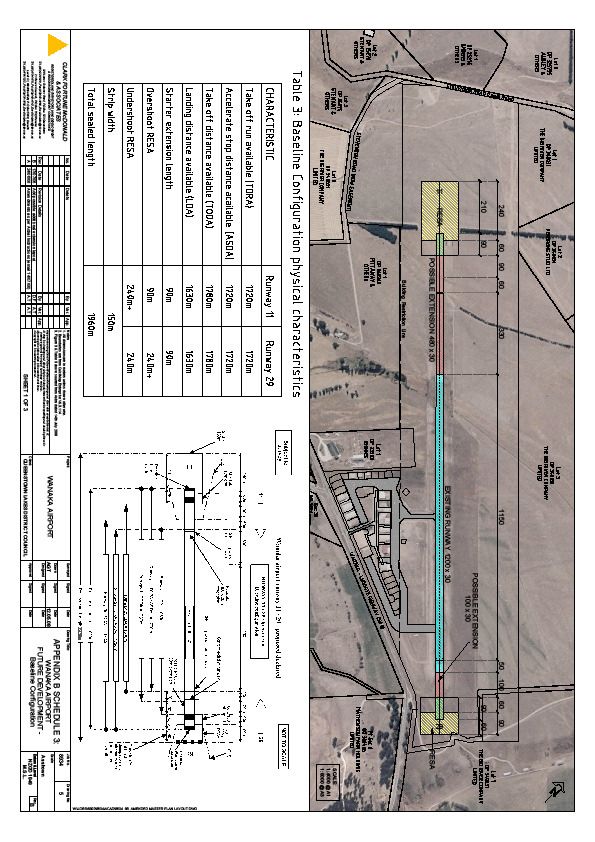
7.1 Runway....................................................................................................................28
7.1.1 Runway Strip Width ........................................................................................28
7.1.2 Side Clearances ..............................................................................................30
7.1.3 Obstacle Limitation Surfaces .........................................................................30
7.1.4 Runway End Safety Area (RESA) ...................................................................31
7.1.5 Runway Length ...............................................................................................31
7.1.6 Runway Width (sealed strip)……………………………………………………… 34
7.1.7 Main Runway Strength....................................................................................35
7.1.8 Proposed Alternative Runway Alignment......................................................36
2 V.2. 41 29/09/2008
Wanaka Airport
Master Plan WAMC

     7.2 Taxiways & Clearways............................................................................................37
       7.2.1 Taxiways ..........................................................................................................37
       7.2.2 Helicopter Clearways ......................................................................................40
     7.3 Aprons .....................................................................................................................40
       7.3.1 Fixed Wing Aircraft Apron..............................................................................40
       7.3.2 Helicopter Apron .............................................................................................43
8.     Air Noise Assessment ................................................................................................44
     8.1   Predicted Airport Noise Contours…………………………………………………..44
     8.2   Noise Performance Standards..………………………………………………….….44
     8.3   INM Model………………………………………………………………………………..44
     8.4   Terrain………………………………………………………………………………….….44
     8.5   Aircraft Taxiing……………………………………………………………………….….45
     8.6   Standard INM Aircraft Data………………………………………………………….…45
     8.7   Helicopters…………………………………………………………………………….….46
     8.8   Engine Testing…………………………………………………………………………...46
9.     Airport Services and Tenant Requirements ..............................................................47
   9.1 General Guidelines for on-Airport Operations......................................................47
   9.2 Passenger Terminal Building.................................................................................47
   9.3 Flight seeing Operations (Fixed Wing)..................................................................50
   9.4 Helicopter Operators ..............................................................................................50
   9.5 Parachute Operators ..............................................................................................50
   9.6 Warbirds and Aerobatic Flight Operators .............................................................51
   9.7 NZ Fighter Pilots Museum Trust ............................................................................53
   9.8 Aircraft Engineering ...............................................................................................53
   9.9 Private Hanger/General Aviation Area...................................................................54
   9.10 Cafeteria .................................................................................................................54
   9.11 Rental Car Operators.............................................................................................54
   9.12 Retailers..................................................................................................................55
   9.13 Car Parking ............................................................................................................55
   9.14 Project Pure (Waste Water Plant) .........................................................................55
10.    Rescue Fire Services (RFS) ......................................................................................
   10.1 Other Operational Requirements &
   Issues……………………………………………………………………………………………..54
   10.2 Air Traffic Control ..................................................................................................57
   10.3 Fuel .........................................................................................................................57
   10.4 Scheduled Night Operations ................................................................................58
   10.5 Good Neighbour Protocols ...................................................................................58
   10.6 Landscaping...........................................................................................................59
   10.7 Environmental Issues............................................................................................59
   10.8 Realignment Proposal of Roadway SH6 ..............................................................59
11.        Schedule of Development Tasks and Capital Works ...........................................60
     11.1 Development and Planning Tasks .........................................................................60

                                                                3                                          V.2. 41 29/09/2008
Wanaka Airport
Master Plan WAMC

  11.2     Major Capital Works Items .................................................................................60
12.      Submissions received to Discussion Draft Master Plan – JUNE 2008................60

Appendix A - References
Appendix B – PLANS

                                                       4                                      V.2. 41 29/09/2008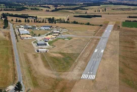
Wanaka Airport
Master Plan WAMC

1.


The Master Plan defines key tasks and works likely to be required at Wanaka
Airport with emphasis on the period 2009 -2019.

We have ranked the Planning Tasks and Capital Works in current priority order
but these are not costed in this plan. Cost detail is or will be included in specific
studies and reports.

1.1            Development and Planning Tasks

     i.   Undertake consultation with airport users and stakeholders based on the
          Master Plan presented herein.
  ii.     Complete the designation process and implement changes to the District
          Plan for revised airspace designation and noise boundaries.
 iii.     Review and make recommendations regarding the most appropriate
          governance structure for the airport.

 iv.      Prepare a comprehensive development report and business case study
          for the development of the northern hangar area.
  v.      Prepare a long - term business plan.
 vi.      Negotiate lease termination to secure site for future passenger terminal
          building.

 vii.     Prepare all documentation and complete the full process for certification
          of the airport under CAA Part 139.

viii.     Ensure adequate protections are put in place to ensure the on-going
          future of the War birds Over Wanaka Air show event due to the
          significant economic benefits for the Wanaka, Queenstown Lakes District,
          and surrounding districts.

1.2            Major Capital Works Items

     i.   Seal access roads - Spitfire and Mustang Lanes.

  ii.     Seal Taxiway to Southern Hangars.

 iii.     Construct access road to northern hangar development.

 iv.      Construct passenger terminal building.

  v.      Extend main aircraft apron.

 vi.      Construct new car parks.

 vii.     Extend runway as required.
          5
                                                                       Revision 2.40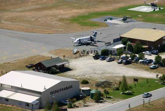
Wanaka Airport
Master Plan WAMC

2.


In July 2001, the Wanaka Airport Manager commissioned Peak Projects
International Ltd to assist in the preparation of an Outline Master Plan1 for the
future development of Wanaka Airport.

Specific issues addressed then included:

      •    Allocation of new leased sites for tandem parachute operators and for
           other potential new commercial and private tenants;

      •    Identification of key planning issues to facilitate the future introduction of
           scheduled air services; and

      •    Preparation of an initial plan in sufficient detail to secure funding for a full
           master plan and feasibility study.

This Master Plan report updates the Outline Plan (2002) and incorporates
significant components/aspects of the airport’s development since that time,
including:

      •    Purchase of an additional 90 hectares of land;

      •    The commencement of scheduled air passenger services; and

      •    Additional survey and runway planning.

This expanded Master Plan forms the basis for planning the development of
Wanaka Airport with the intention that both the Master Plan and the associated
Air Traffic Forecasts be updated on a regular basis.

1
    Outline Master Plan. Peak Projects/Johnston (August 2002)
           6
                                                                            Revision 2.40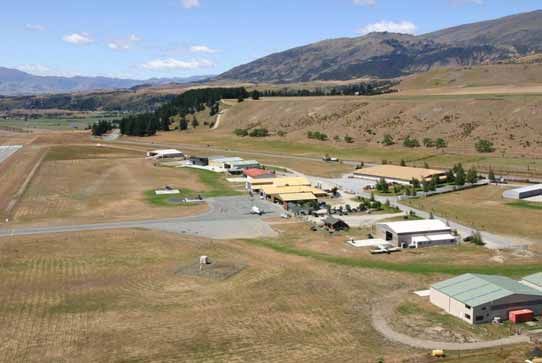
Wanaka Airport
Master Plan WAMC

3.

3.1       History

      The original airport at Wanaka was located near Mount Iron and used by a
      number of owners of fixed wing aircraft. During the tourist season in the
      1950s, Southern Scenic Air Services Ltd became one of the first commercial
      companies to use the strip. It became clear that this strip would never be
      satisfactory as a municipal airport one of the main reasons being the very
      close proximity to Wanaka Township and concern about aircraft noise. The
      present site near Luggate was deemed the most practical alternative site.
      This site was used originally by the Gore Aero Club for pilot training some 40
      years ago. The owner farmer with an interest in aviation made a paddock
      adjacent to State Highway 6 available for aircraft, which included, from the
      late 1960s, Cessna aircraft operated by Tim & George Wallis.

      In 1978, a price was negotiated for the purchase of land at the current site.
      The new Wanaka Airport was opened at the beginning of 1983 with an initial
      sealed strip of 15m wide. In 1986, the runway was lengthened to 1200 m with
      a grass-seeded extension. This proved unsuccessful and over the next two
      years, the Airport was upgraded with a new sealed runway and taxiway at a
      cost of $750,000.2

      In 1990, Wanaka Airport transferred into the ownership of Queenstown Lakes
      District Council (QLDC) from Vincent County Council and placed under the
      management of the Queenstown Airport Corporation. Subsequently in 1998
      authority for the airport was transferred to a Wanaka based Management
      Committee and Airport Manager.

      In 2004/6, parcels of land amounting to an additional 90 hectares were added
      to the airport by the purchase of land from Alpine Deer Group, Big River Co.
      Ltd. and a neighbour Mr. Pittaway. These parcels have protected the airport’s
      operations and have precipitated the current process of airport designation
      revision (refer Section 3).

      Few areas in New Zealand have experienced the recent growth of Wanaka
      and the Southern Lakes area. Queenstown-Lakes has retained its position as
      the fastest growing region of New Zealand, recording a census night
      population in 2006 of 32,500, up 29.2% on 2001. Wanaka’s population
      increased by 45% to 6,440 over the 5 year period 2001 to 2006.

      Wanaka Airport lies clearly amongst the top rank of smaller NZ airports.
      Particular strengths include a superb location for aircraft operations, its
      proximity to town, its international Air Show reputation, and the fact that it is a
      tourist destination in its own right.

2
    Wanaka and Surrounding Districts" Irving Roxburgh 1990
          7
                                                                         Revision 2.40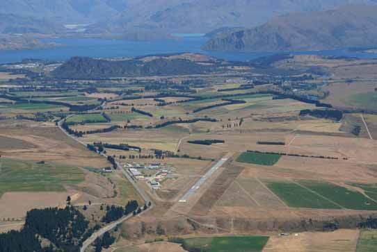
Wanaka Airport
Master Plan WAMC

3.2      Mission Statement

      Wanaka Airport does not presently have a formal mission statement but one
      similar to the following might be appropriate (with due acknowledgement to
      the Taupo Airport Strategic Review.3)

      “To operate a safe and reliable airport facility based on sound business
      principles that services and promotes the range of aviation operations
      including scheduled air transport services for the economic and social well
      being of Wanaka and surrounding districts.”

      Further requirements (significant to Wanaka) are:-

      “To recognise and protect the future of the War birds Over Wanaka Air show
      event due the significant economic benefit for Wanaka Ward and surrounding
      districts.”

      The related long-term strategies, which follow logically, might then be defined:

         •       “To provide a gateway to Wanaka Ward and surrounding districts
                 and provide a complementary facility to Queenstown Airport for the
                 Southern Lakes area.

         •       To maintain and improve airport land and airport facilities to meet
                 the needs of all airport users in accordance with sound business
                 principles based on forecast demand.

         •       To promote the maintenance and development of scheduled air
                 transport services to meet the travel requirements of business,
                 residents, visitors and tourists. “ 4

3.3      Site Description 5

      Wanaka Airport is located on a flat elevated river terrace to the east of the
      Clutha River. The terrace drops away steeply to the SE some 500m from the
      end of the existing runway. The Clutha River is below the terrace to the east
      and the airport is screened from the township of Luggate by high ground
      leading to Mount Barker and by a complex of terraces. To the north lies
      farmland and the Poplar Beach Subdivision.

3
  Taupo Airport Authority Strategic Review. Taupo District Council, Errol Millar, Arrus Knoble
(NZ) Ltd. April 2003
4
  Adapted from Taupo Airport Authority Strategic Review TDC Millar, Knoble 2003
5
  Proposed Designations at Wanaka Aerodrome. Beca ,Carter Hollings & Ferner Ltd October
1995
         8
                                                                               Revision 2.40
Wanaka Airport
Master Plan WAMC

      The following photo depicts the airport location (runway visible in centre of
      photo)

      The airport lies in an open rural locality – generally well separated from
      concentrated residential settlements and the terrain in the immediate vicinity
      of the runways is flat. The soils are not of high quality, being Luggate shallow
      sandy loam.

      The airport has frontage and vehicular access to State Highway 6 (SH6).

      The airport is recognised as well sited, not only because it is located away
      from populated urban areas, but also because of its topographical and
      climatic advantages. An AirBiz/Beca survey commissioned in 19956 assessed
      suitability criteria for five airport sites in the Lakes District area and concluded
      that Wanaka was top rated in all respects but judged second only to
      Queenstown because of the latter’s proximity to the Queenstown urban area
      and it’s existing infrastructure.

6
    Queenstown Airport Alternative Site Study AirPlan and Beca for QLDC October 1995
          9
                                                                             Revision 2.40
Wanaka Airport
Master Plan WAMC
The land area occupied by the airport (including current and proposed airport
designations) includes the lots described below:
• Lots 1 – 5 DP 18824
• Lots 10 and 11 DP 24410
• Lots 7 and 8 DP 22637
• Lots 2 - 5 DP 23517
• Lot 6 DP 22636
• Lot 6 DP 24685
• Lot 1 DP 341605
• Lot 2 DP 34105 [owned by NZ Fighter Pilots Museum Trust]
• Lots 4 – 5 DP 340031
• Lot 2 LT 368240 (from subdivision of Lot 1 DP 300052)
• Lots 1 & 2 DP 26239
• Legal Road
Wanaka Airport has two runways. The main runway (11/ 29) has a 1200m
paved length and is 30 m wide and there is an additional grass runway
parallel to the NE side of the main sealed runway. This is 840m long x 40m
wide. In general, the majority of aircraft use the main runway, although the
grass is used by smaller and vintage aircraft – particularly for landing. The
two runways are too close to allow simultaneous operations.
Figure 3-1: This photo shows the extent of the new airport boundaries following the
2005/6 land purchases.
The road in immediate foreground marks the new NW boundary, while the road on the
left of photo lies 50m inside the new northern boundary. To the SW the new land
extends 100m from the current boundary fence. The earlier boundaries lie close to the
sealed runway, which is visible centre-rear.
10
Revision 2.40Wanaka Airport
Master Plan WAMC
Figure 3-1a: another view (this from the eastern aspect) showing the extent of the new
airport boundaries.
3.4 Airport Environs
The Airport is located in the rural general zone. However, there are a number
of other non-rural activities, which have developed or are developing around
the area, which may have a potential impact on the development of the
airport, including:
• An expanding Luggate township, with new subdivisions, approximately
2km to the south-east and several houses along SH 6A, about 1 km
from the threshold of the RWY 29;
• The Wanaka Transport Museum & Boutique Brewery occupies a site
bordering airport land to the SW and adjacent to State Highway 6.
This site, privately owned site, would if ever made available, offer a
very suitable area for future expansion of airport infrastructure);
• The “Have-a-Shot” tourist activity centre on the opposite side of State
Highway 6;
• The development of 17 rural residential sites in the Poplar Beach area
generally, and particularly along the Clutha River and terraces
approximately 1-2km to the NE and parallel to the main runway to the
NW;
• Two house sites to the NW of the airport – approx 500m from the
airport new NW boundary;
11
Revision 2.40Wanaka Airport
Master Plan WAMC
• The waste water treatment works constructed by QLDC in the NE
corner of airport land;
• Other residential applications are planned along the airport northern
boundary; and
• an “aero park” subdivision on the Pittaway land adjacent to the toy and
transport museum.
Figure 3-2: Wanaka Airport lies 9 km by road (SH6) from the main township (top left in
photo).
12
Revision 2.40Wanaka Airport
Master Plan WAMC
3.5 Existing Airport Development
The Airport has a number of established commercial and private facilities on
leased sites within the airport environs including:
• flight seeing operators;
• commercial helicopter operators and a helicopter training school;
• tandem parachute operator;
• War birds museum and War birds Over Wanaka base;
• vintage, classic and fighter aircraft restoration and operation;
• aircraft engineering and servicing (most recently turbine helicopter
maintenance);
• private general aviation and helicopter hangars;
• meteorological station; and
• three aircraft re-fuelling facilities.
Figure 3-3: This photo shows the buildings at Wanaka Airport (at January 2007).
Private Hangars and War birds are located adjacent to SH 6.
Scheduled and charter passenger services are located near the main apron & taxiway
while the helicopter zone lies to the SE.
The skydive hangar and PDZ are situated furthermost to the SE at the Luggate end of
the airport. The neighbouring Transport Museum borders the airport to the W and SW.
13
Revision 2.40Wanaka Airport
Master Plan WAMC
3.6 Airfield Operations
The airport currently operates as a non-certificated airfield. It does not
therefore fall within the jurisdiction of Part 139 of the Civil Aviation Rules
relating to the Certification of Aerodromes.
A non-certificated status means that Civil Aviation Rules place the
responsibility on the operator of an aircraft to ensure that the airport is
suitable for their particular aircraft.
A non-certificated status also precludes the operation of scheduled flights for
aircraft with seating capacities of 30 persons or over.
Current airfield operations at the airport include:
• Air New Zealand scheduled flights with Beech 1900D aircraft (19 seat
passenger capacity);
• Flight seeing (Britten Norman Islander and Cessna C177 and C206
aircraft);
• Helicopter flight seeing, training and commercial operations with R22,
R44, AS350B and H500 aircraft;
• Tandem sky-diving flights (Cresco and C180 aircraft) including the
landing of parachutists on the airport;
• Private general aviation with a large variety of aircraft fixed wing types;
• Private helicopters; (R22 and R44);
• Tourist flights in Tiger Moth, Pitts Special and War birds aircraft
including Aero L 39 Albatros and P51 aircraft;
• Non-scheduled charter operations ( Business jets, Convair 580, ATR
72, Dash 8 and others ;
• Military aircraft including King-Air, Hercules C130 , Airtrainers,
Iroquois and Seasprite Helicopters; and
• Specific aircraft movements associated with the bi-annual Warbirds
over Wanaka Air show and other Air show events.
14
Revision 2.40Wanaka Airport
Master Plan WAMC
Annual aircraft movements (landings and takeoffs), estimated from landing
fees received are shown below in Table 1-1.
Table 1-1 Aircraft Operations (2006) estimated.
Category Aircraft Type No of Landings
per year
(Estimated)
Scheduled Flights Beech1900D 850
Flight seeing Operators BN2-A Islander 165
Cessna 177 770
Cessna 206/185 2,390
Pilot Training Cessna 172 2,148
Light Sports A/C 1,494
Charter Flights Convair 580/ATR72 etc 12
Skydive Operators Cresco & other 4,600
Helicopter Operators Robinson R22/44 3,384
H500/AS350 2,110
Private/General Aviation Light aircraft 3,195
Warbirds and Adventure Aircraft 314
Total 21,432
4.
4.1 Current Aerodrome Designation
The original airport site of 81.5 Ha (including the parcels of land previously
owned by the Alpine Deer Group) is designated currently under the District
Plan for Aerodrome Purposes.
The present designation allows for:
• Aviation activities including operation of vintage and classic aircraft;
• Associated buildings and infrastructure including a cafeteria; and
• A 197m extension of the existing runway.
This designation is in the process of amendment by proposed variations to
the District Plan, to extend the designation to include the new land now
owned by the airport.
15
Revision 2.40Wanaka Airport
Master Plan WAMC
4.2 Building Restrictions
The District Plan provides a Building Restriction Area, which encompasses
the airport site, plus some portions of neighbouring properties, within which
the principal restrictions on buildings are:
• that buildings must not exceed 9m in height;
• a minimum set-back of buildings from the runway centreline of 200m
on the northern side and 150m on the southern side; and
• The building setback is 124m. This allows buildings up to 7m high
under the 1:7 side clearance based on a 150m wide strip.
Amendments to these restrictions are not required in the currently proposed
variations to the District Plan.
4.3 Current Air Noise Boundary
The Air Noise Boundary (ANB) and Outer Control Boundary (OCB) are
delineated in the District Plan, but specific restrictions on activities within
these areas are not specified. Restrictions therefore rely on the more general
provisions of the Resource Management Act and the New Zealand Standard
for Noise Management and Land Use Planning (NZS 6805).
The boundaries defined in the plan were based on the report prepared by
Beca Carter Hollings and Ferner for QLDC in 1995.7 This report included a
noise modelling exercise to predict the 65 Ldn and 55 Ldn noise contours.
This modelling exercise used Yr.2010 as a planning horizon and included an
estimate of the numbers and types of aircraft that take-off (and land) on a
typical (busy) day.8
Typically (as is also the case for the Queenstown airport), the restrictions that
apply within these areas are:
• Air Noise Boundary (65 dBA) - only airport related activities are
allowed, and
• Outer Control Boundary (55 dBA) - any existing accommodation
building must be acoustically insulated to maintain a maximum interior
noise level of 40 dBA plus restrictions on use and noise insulation of
new buildings.
As noted above the recent development of and further applications for
residential subdivision in areas adjoining the airport boundaries and/or
7
Proposed Designations at Wanaka Aerodrome. Beca ,Carter Hollings & Ferner Ltd October 1995
8
Proposed Designations at Wanaka Aerodrome. Beca ,Carter Hollings & Ferner Ltd October 1995
16
Revision 2.40Wanaka Airport
Master Plan WAMC
operational airspaces has highlighted the need to provide adequate airport
protection measures.
As part of the designation process currently underway, it is proposed to
amend the ANB and OCB boundaries based on the air traffic forecasts
contained in this report.9
4.4 Airport Height Controls
The District Plan defines take-off, approach and side planes, which define the
maximum heights of structures and other obstacles such as trees. The critical
slopes defined in the District Plan are:
• Take-off and approach slope of 1:50 at both ends of an extended main
runway strip;
• Transitional slope from the edge of the runway strip (150m wide) at a
slope of 1:7; and
• Inner horizontal and conical surfaces in accordance with CAA AC
139.06.
The existing approach controls will be revised in the process outlined below to
include both the existing runway length and alignment and the proposed
runway layouts.
4.5 Reverse Sensitivity Airport Protection
Some eight years ago the WAMC recognised the necessity to protect the
Airport from residential and other development in the vicinity.
With the support of QLDC, airport policy aims to secure the long term viability
of the airport by ensuring development in the immediate vicinity of the airport
is appropriate to and recognises the existence of airport related activities.
This will be achieved through the use of a number of planning tools including
designation and the District Plan and, where necessary, through the use of
Restrictive Covenants on Titles to address potential reverse sensitivity, noise
& other airport protection issues.
4.6 Designation and District Plan
Wanaka Airport is designated for ‘Aerodrome Purposes’ in the Queenstown
Lakes District Plan. This designation is intended to protect the operational
capability of the airport, while at the same time minimising adverse
environmental effects from aircraft noise. The designation primarily
addresses activities associated with the use the aerodrome but also applies in
respect of airspace near the airport including take off and approach fans and
obstacle limitation surfaces. The Queenstown Lakes District Plan also
9
Wanaka Airport Air Traffic Forecasts. WAMC October 2005.
17
Revision 2.40Wanaka Airport
Master Plan WAMC
includes rules relating to activities occurring within areas potentially affected
by noise associated with the airport.
The airport designation is currently being updated to incorporate newly
purchased land and to accommodate airport growth projections. Concomitant
with this, QLDC is reviewing the provisions of the District Plan as they pertain
to Wanaka Airport. In particular, this will include a review of the adequacy of
existing air noise boundaries in light of proposed growth in airport operations
and activities. Revision of air noise boundaries will be consistent with New
Zealand Standard for Noise Management and Land Use Planning (NZS
6805).
4.7 Restrictive Title Covenants
Aircraft noise can have an adverse impact on the quality of lifestyle for people
living in residential properties near airports. Appropriately designed and
developed buildings will significantly mitigate the effects of noise associated
with airport activities. However, people soon forget they have built or bought
near an operating airport facility and new residents moving into the area may
be less aware of non-visual elements of the existing environment. This can
result in reverse sensitivity issues, where activities sensitive to an existing
activity choose to locate nearby but subsequently attempt to inhibit its
operation.
Wanaka Airport has sought to obtain no complaint covenants on neighbouring
residential property developments wherever possible to ensure current and
future property owners recognize the presence of the airport and do not seek
to limit its operation.
The current Airport Restricted Covenants require (in simplified terms):
• That the land - owner occupies the land at their risk regarding any
disturbance and annoyance from the airport.
• That the owner permits the Airport to carry on its lawful activities
without interference, restraint, or complaint.
• That the owner will not restrict any further development of operations
of the airport.
• That there will be no further subdivision of the property (this proviso
was of special importance in the case of the Poplar Beach
subdivision).
• That in the case of Poplar Beach owners/occupiers and the biennial
Warbirds Over Wanaka Air show or similar, the ability for the
organisers to prevent any open air assembly of persons and/or require
vacation of all persons from the properties for the duration of the
event.
18
Revision 2.40Wanaka Airport
Master Plan WAMC
These covenants are binding upon the owner and the owner's successors in
title to the land.
4.8 Certification of the Airport
The airport will need to be certificated under CAA Part 139 Rules Aerodromes
-Certification, Operation and Use prior to the operation of scheduled services,
which use aircraft with more, that 30 seats (e.g. Dash 8 or ATR aircraft). The
forecasts suggest that certification might be required by Yr. 2013.
CAA Part 139 prescribes specific requirements for certification, which are
detailed in an Aerodrome Certification Exposition and include:
• Aerodrome Design Requirements – physical features, obstacles,
visual aids, equipment and installations.
• Personnel Requirements – appropriate to maintain services and
facilities.
• An Aerodrome Emergency Plan.
• Public Protection – security fencing etc.
• Wildlife Hazard Management.
• Aerodrome Maintenance Programme.
• Aerodrome Inspection Programme.
• Aerodrome Internal Quality Assurance Procedures.
4.9 Adjacent Visitor Accommodation Zone
A special visitor accommodation zone (lying within the rural general zone)
borders the airport boundary to the Southwest and is accessed from SH6.
We understand that a primary justification for approval of this zone change
was to provide for future infrastructure (viz. accommodation) for Wanaka
Airport.
The site offers some opportunity for an ”aero park” facility.
19
Revision 2.40Wanaka Airport
Master Plan WAMC
5.
In 1998 airport management passed from the Queenstown Airport Corporation
(QAC) to a Wanaka based Management Committee of QLDC with a locally based
Airport Manager. We believe that the airport has operated satisfactorily with this
“committee based” management structure for the last 10 years. The airport has
achieved an operating surplus each year (of about 30 to 40% of revenue), that
has been used to fund capital improvements.
Over this period Wanaka airport operations have increased significantly with a
more than trebling of aircraft movements. In addition, sustainable scheduled air
services by Air New Zealand commenced in March 2004, on a once daily
increasing to twice daily in 2006.
Indications are that traffic through the airport and usage of its facilities will
increase significantly over the future in conjunction with the resident population
expansion of Wanaka Ward and increasing tourism through this destination.
The airport continues to benefit from strong community support and we believe
maintains a good relationship with airport user groups, a matter of amplified
importance when structural changes in governance are mooted.
Given recent growth and increased QLDC investment the issue arises as to
which ownership and management structure is best suited to this facility to meet
the desired community outcome already identified through the Wanaka 2020
process, namely:
“Effective and efficient infrastructure that meets the needs of growth”
The optimum structure will:-
• Maximise the benefit of the airport for ratepayers, Wanaka airport users
and the wider community;
• Facilitate the growth of scheduled air services and other airport
activities;
• Provide for efficient economic operation including the ability to fund
capital projects for essential items of airport infrastructure; and
• Manage the protection of future airport operations and associated
airspace through the Designation and District Plan.
Options for future airport governance include:-.
• Retain the status quo;
• Consider potential cooperation with QAC in one form or another.
• Move to a corporate model structure such as a Council Controlled
Trading Organisation (CCTO) with a local Board.
20
Revision 2.40Wanaka Airport
Master Plan WAMC
QLDC is reviewing various future governance options for Wanaka airport and has
determined that a new structure should be in place by 31st March 2009.
6.
6.1 District Plan Growth Scenario
The District Plan rules and the associated noise boundaries were based on
the following growth scenario from the Beca Carter Report of 1995:10
Table 6-1 Earlier Predictions of Airport Operations: Take-offs per Day –
Beca Report October 1995 11
Aircraft Type 1994 2010
Scheduled Passenger Aircraft
Bae 146 0 2
Boeing 737 0 1
Hawker Siddley 0 2
Tourism and Private
DC3 0 2
BN2-A Islander 4 8
General Aviation (incl. flight seeing) 10 25
Warbirds 1 5
Helicopters 2 10
Total Take-offs per day 17 55
These projections are now seen as conservative in terms of take-off numbers,
with the Yr. 2010 forecast exceeded already).
Conversely, the projections for jet operations appear optimistic and are
unlikely to be met within the forecast period to Yr.2010.
6.2 Revised Growth Predictions – Wanaka Airport Traffic Forecasts 2006
to 2036
A planning window of approximately 30 years was proposed for this report.
The Air Traffic Forecasts predict the growth of air traffic and permit an
assessment of airport user requirements through to the year 2036.
This methodology utilises standard practice at other airports around New
Zealand and the same 30-year planning horizon used for the Queenstown
Airport.
To formulate a prediction for future growth of Wanaka airport, general trends
were analysed including recent forecasts for Queenstown Airport. The
10
Proposed Designations at Wanaka Aerodrome Assessment of Environmental Effects. QLDC
Beca October 1995
11
Proposed Designations at Wanaka Aerodrome Assessment of Environmental Effects. QLDC
Beca October
21
Revision 2.40Wanaka Airport
Master Plan WAMC
Queenstown forecasts were prepared by AirBiz, a respected aviation
consultant, who suggested the following growth parameters.
Comparative Queenstown Airport Forecast Growth Projections12
Table 6-2 Queenstown Airport growth predictions as updated by AirBiz
in September 200613
2006-2013 2014-2023 2024-2036
International 3.1% 2.9% 3.2%
Domestic 3.1% 2.9% 3.2%
Flight seeing 1.1% 1.9% 1.0%
GA 1.1% 1.9% 1.0%
2005-2011 2012-2016 2017-2025 2025-2035
Helicopter 5.5% 3.5% 1.9% 1.0%
s
6.3 Wanaka Area Growth Trends
• The Wanaka Ward area has experienced steady growth over the last 4
census periods with an increase in resident population of 62% in the last
10 years.
• Trend analysis suggests a resident population of up to 15,000 by Year
2015.
• The demographics show a gradually aging middle –aged population.
• Median age in 2001 was 39.8 years.
• Wanaka international overnight visitor projections by the Tourism
Research Council are for a 5.9% per annum increase to 2010.
• Domestic overnight visitors are predicted to increase at a much lower
rate.
• Annual population growth rates projected by the QLDC Growth
Management study 14 are 7%, falling to 3% per annum by 2021 with an
average of 4.66% per annum.
• Visitors overall growth rate (as projected by the QLDC Growth
Management study) for the period 2006-2021 is 4.02% per annum.
12
Queenstown Airport Master Plan July 2004.Airplan
13
Queenstown Airport Master Plan July 2004.Airplan
14
Queenstown and Wanaka Growth Management Options Study report to QLDC Hill Young
Cooper Ltd. Feb 2004
22
Revision 2.40Wanaka Airport
Master Plan WAMC
6.4 General Growth Predictions Wanaka Ward
General predictions with respect to tourism and development in the region
include:
• a significant increase in tourism numbers based in Wanaka as
accommodation facilities are developed, and Queenstown capacity
restricts continued exponential growth;
• the continued development of the Wanaka Warbirds and Warbirds
over Wanaka Air show, including potentially new operators and
complimentary activities;
• a large increase in privately owned helicopters and fixed wing aircraft
based at the airport owned by incoming new residents;
• the development of aircraft servicing (especially turbine helicopter)
facilities;
• an increase in flight-seeing operations direct from Wanaka to meet
increased foreign tourist numbers;
• the trend for helicopter tourist activities to increase at a much faster
rate than light aircraft, as evidenced at Queenstown airport; and
• increase in scheduled aircraft services to/from Christchurch and
charter/winter services from Wellington and Auckland.
• Increased usage (including overnight parking) of the airport by
executive jet aircraft.
6.5 Forecast Air Traffic Growth Scenario 15
Based on the above predictions, a preliminary growth scenario developed for
Wanaka airport suggests inter alia: - (refer Air Traffic Forecasts for full details)
• gradual increase in Christchurch scheduled services using the Beech
1900D aircraft;
• further increase in scheduled services capacity from about Yr.2013 –
2017 to/from Christchurch and (perhaps) Wellington with the use of
larger Dash 8 (50 pax) and ATR (66 pax);
• the introduction in about Yr.2020 of domestic jet aircraft scheduled
flights to/from Christchurch (and possibly Wellington and Auckland)
using the B737-300 or similar aircraft;
15
Wanaka Airport Air Traffic Forecasts. WAMC October 2005
This forecast prepared in-house by Wanaka Airport has been peer reviewed by Zomac Planning
Solutions Ltd. Astral Limited and Air Plan (Air Biz Forecast Demand Review).
23
Revision 2.40Wanaka Airport
Master Plan WAMC
• the possible replacement of ATR 72 with Dash 8 Q400 aircraft in
Yr.2026;
• an increase in flight seeing services based on tourism increases and
the transfer of local flight seeing operations to larger, more efficient
aircraft such as the Cessna Caravan or Airvan GA8;
• an increase in helicopter operations in accordance with recent and
higher than proportional growth (similar to that experienced at
Queenstown) – between 6.7% and 8.4% pa over 10 years; and
• the continued growth in war bird and vintage and aerobatic aircraft as
War Birds over Wanaka and similar operations continue to develop
Wanaka’s reputation as an aviation adventure base.
Table 6-3 Proposed Average Annual Growth Rates of Aircraft
Movements
Aircraft Movements Av.Growth Rates Av.Growth Rates
Proposed Proposed
(By category of pax 2006-2025 2025-2036
type carried)
Scheduled pax 9.40% 2.77%
Charter pax 8.60% 2.90%
Flight seeing
- to 2012 6.50% 1.90%
- from 2012 6.00%
Pilot training
- Cessna 5.00% 1.90%
- Light Sports A/C 7.40% 1.90%
General aviation 5.50%
Skydiving 5.50% 1.90%
Warbirds 3.90% 1.90%
Helicopters
- R44/22 6.70% 2.25%
-AS350/H500 8.40% 2.25%
Using the above parameters and growth rates a table of aircraft movements
in 2036 is developed for use as the basis for planning of facilities required at
Wanaka Airport in 2036.16
16
Wanaka Airport Air Traffic Forecasts WAMC – refer APPENDIX B Schedules 8 and 9.
24
Revision 2.40Wanaka Airport
Master Plan WAMC
A summary of the aircraft and passenger movements (landings and takeoffs)
for the years 2006, 2016, 2026 and 2036 are detailed in the table and figures
below:
Table 6-4 Summary of Forecast Annual Aircraft Movements17
(by aircraft type or current equivalents)
Aircraft Type 2006 2016 2026 2036
Scheduled A/C
B737/AS320 nil nil 2,254 2,999
ATR72 nil nil nil nil
Dash* Q400 2,190 2,915
Dash8 Q300 nil 2,555 nil nil
Beech1900D 850 nil nil nil
Non-Scheduled Charter A/C
Convair 580/ATR 72 etc 12 26 54 71
Flight seeing A/C
BN2-A Islander 165 nil nil nil
Cessna 206/185 2,390 nil nil nil
Cessna 177 770 nil nil nil
Cessna Caravan 1,014 1,689 2,039
Airvan GA8 1,014 1,689 2,039
Pilot Training A/C
Cessna 172 2,148 3,499 5,531 6,676
Light Sports A/C 1,494 2,434 3,847 4,644
General Aviation A/C
Cessna etc 3,195 5,885 8,912 10,757
Skydiving A/C
Cresco etc 4,600 7,493 11,845 14,298
Warbirds + Adventure A/C 314 478 663 801
Helicopters
R22/44 3,384 6,352 11,448 14,301
H500/AS350 2,110 3,961 7,138 8,917
Total 21,432 34,711 57,260 70,457
Note : ATR 72 aircraft are forecast to operate between 2017 and 2025.
17
Movements include “Touch and Go” landings where applicable e.g. training sorties. For detailed
statistics Refer Airport Air Traffic Forecasts – extract APPENDIX B SCHEDULES 8 and 9.
25
Revision 2.40Wanaka Airport
Master Plan WAMC
Table 6-5 Summary of Forecast Annual Passenger Movements (by
aircraft type or current equivalents)
Aircraft Type 2006 2016 2026 2036
Scheduled A/C
B737/AS320 nil nil 214,534 305,924
ATR72 nil nil
Dash8 Q400 nil 113,442 155,297
Dash 8 Q300 89,425
Beech1900D 11,628 nil nil nil
Non-Scheduled Charter A/C
Convair 580/ATR 72 etc 510 1,105 2,274 3,027
Flight seeing A/C
BN2-A Islander 989 nil nil nil
Cessna 206/185 8,963 nil nil nil
Cessna 177 1,732 nil nil nil
Cessna Caravan nil 9,128 15,203 18,352
Airvan GA8 nil 4,563 7,600 9,173
Pilot Training A/C
Cessna 172 2,685 4,374 5,531 6,676
Light Sports A/C 1,868 3,042 3,847 4,644
General Aviation A/C
Cessna etc 6,390 11,770 17,823 21,514
Skydiving A/C
Cresco 13,800 22,479 35,534 42,894
Warbirds + Adventure A/C 314 478 663 801
Helicopters
R22/44 5,076 9,528 11,448 14,301
H500/AS350 4,115 7,723 13,919 17,388
Total 58,070 163,615 441,818 599,991
26
Revision 2.40
                27


                                                                                                                                                                                                                                                          Wanaka Airport


                                                                                                                                                                                                                                                          Master Plan WAMC


                                                                                                     !"


Revision 2.40
Wanaka Airport
Master Plan WAMC

7.        ! "

7.1       Runway

7.1.1     Runway Strip Width

      The runway strip width is the designated area either side of the runway
      centreline, which is unobstructed, level, and of sufficient strength to prevent
      serious damage to any aircraft, which might stray from the (sealed) runway
      during take-of or landing. The strip must be clear of obstacles such as
      buildings or fences.

      Wanaka Airport currently has a defined strip width of 90m.

      Runway strip requirements for various aircraft types are tabulated below.

      The Civil Aviation rules define minimum strip widths, which are determined
      by:

          •    the type of aircraft;

          •    day or night use; and

          •    whether ILS or other precision approach systems are provided.

      Table 7-1 Runway Strip Width Requirements18

        Airport classification                               Aircraft Cat.       Strip width
        Domestic, non-instrument, day only for aircraft at   3 or 4              90m
        or below 22.7T MCTOW
        Domestic, non-precision approach (day or night)      1,2,3, or 4         150m
        Domestic precision approach                          1 or 2              150m
        Domestic precision approach                          3 or 4              220m
        International non-precision approach                 3 or 4              150m
        International precision approach                     3 or 4              300m

      Increasing the current strip width to 150m is recommended in order to allow
      for aircraft over 22.7 tonne MCTOW 19 and for future scheduled operations at
      night.

      The airport has purchased sufficient additional land to provide for this
      upgrade to the current runway.

18
     CAA Aerodrome Design Rules Part 139
19
     Maximum Capacity Take Off Weight
          28
                                                                       Revision 2.40
Wanaka Airport
Master Plan WAMC
Ultimately any decision on the need for and specification of a new runway will
depend on future market and airline requirements and on CAA technical
specifications. The main constraint on future runway capability is believed to
be length rather than width – with elevated ground to the NW and a steep
drop off to the SE.
The master plan supported by 30-year traffic forecasts provides for both
existing runway extensions and the possibility of a new alternative runway to
the north. These facilities provide for future aircraft operations up to B737
standard.
With the purchase of 90 hectares of new land Wanaka airport is able to
provide for the option of a new runway if needed. The location of the
proposed future runway is shown in the master plan in its extreme north
position spaced 93m from the existing runway. In this position 150m strip
width is available for the proposed runway and the existing runway could be
used as a taxiway for the future runway.
The existing main runway and proposed future runway at Wanaka airport are
under the master plan, designed as “instrument - non precision” runways.
Under CAA runway design requirements the strip width required for such
runways is 150m, as exists at most major New Zealand airports, including
Wellington, Queenstown, Invercargill, Hamilton and Rotorua. Only the main
runways at Auckland and Christchurch International airports, which are
classed as “instrument – precision approach” runways have a 300m strip
width, while Dunedin has 220m.
The Airline Pilots Association (ALPA) has requested that a 220m wide runway
strip protection be considered. Refer ASTRAL comments in footnote.20 Wider
runway widths of 220m or 300m strips would be required for “precision
approach” situations, although it should be acknowledged that improvements
in GPS technology and RNP21 navigation has led to an aviation industry view
that 150m strip widths are sufficient for most if not all situations.
There is a total of 243m available for strip width should a future runway not be
placed in its most northerly position shown in the master plan and this could
20
ASTRAL LTD notes “runway strip width requirements”
It is noted that the ICAO Annex 14 standard is for a 300m strip width for precision approach
runways. Astral understands that 220m strip width for domestic precision runways is a somewhat
dated requirement based on the old New Zealand CAA Airport Standards Manual and its long-
term acceptability to CAA cannot be assured.
For these reasons, plus the limited additional reliability benefit precision minima are likely to
provide, Wanaka Airport the master plan shows the option of 150m strip width. It is noted that
Queenstown and Wellington airports are similar. The 150m wide strip does not of course mean
that enhanced navigations systems, including GNSS and augmentation systems cannot be used to
improve reliability of operation and overall safety; however, the minima will not be able to be
reduced below non-precision limits.
21
Required Navigation Procedure – (a navigation technology)
29
Revision 2.40Wanaka Airport
Master Plan WAMC
provide the option of a 220m strip width required for a domestic precision
approach runway. This would be at the expense of retaining the existing
runway as a taxiway – given insufficient lateral separation.
An airspace designation is proposed which will protect both the existing and
future runways, the former in its existing position (with an extension at either
end) and the latter in its most northern position. The airspace designation
permits the future runway to be located closer to the existing runway, should
this be required. This means there is considerable flexibility for Wanaka
Airport to determine the final placement (parallel to the existing runway) of a
future runway to meet the airport layout requirements as they evolve. Refer to
runway length options (below).
7.1.2 Side Clearances
Side clearance or transitional surfaces slope up from the edge of the runway
strip at 1:7. These surfaces should be free of obstructions by buildings, trees
or land.
At Wanaka Airport, the major side clearance issue is the terrace to the
southwest of the Luggate end of the runway. This terrace cuts the side
clearance surface by approximately 12m when allowance is made for a 150m
strip width on the existing runway alignment. Whilst this can be notified by the
appropriate notices in the Aviation Information Publication (AIP), it is likely to
increase the allowable minimum cloud level for future RNP / GPS
approaches. This is a further reason to protect an alternative main runway
location offset to the north of the existing runway.
7.1.3 Obstacle Limitation Surfaces
CAA Rule Part 139.51 requires an airport operator to provide obstacle
limitation surfaces around the airport to ensure safe operation of aircraft
approaching and departing from the airport.
This is calculated by means of height controls based on a series of geometric
surfaces projecting up from the edges of the strip that surrounds the sealed
runway, the intention being to prevent structures and trees from penetrating
these surfaces in areas critical to operational safety and efficiency.
CAA AC’s 139-06A provide details on the extent of these protection surfaces
and applies to runways intended for aeroplanes with over 5700kg maximum
certificated takeoff weight (MCTOW). It is essential that the protection
surfaces appropriate to the largest aircraft type, which the airport plans to
accommodate in the future, should be used; otherwise, the option to
accommodate these aircraft may be lost due to conflicting development
around the airport.
For this reason, it is considered appropriate to base the airspace protection
around the airport on the requirements of AC139-6 AERODROME
STANDARDS & REQUIREMENTS: ALL AEROPLANES CONDUCTING AIR
TRANSPORT OPS.
30
Revision 2.40You can also read