All Your GPS Are Belong To Us: Towards Stealthy Manipulation of Road Navigation Systems - Microsoft
←
→
Page content transcription
If your browser does not render page correctly, please read the page content below
All Your GPS Are Belong To Us:
              Towards Stealthy Manipulation of Road Navigation Systems

                   Kexiong (Curtis) Zeng† , Shinan Liu‡ , Yuanchao Shu§ , Dong Wang†
                           Haoyu Li† , Yanzhi Dou† , Gang Wang† , Yaling Yang†
    † Virginia Tech; ‡ University of Electronic Science and Technology of China; § Microsoft Research

      {kexiong6, dong0125, haoyu7, yzdou, gangwang, yyang8}@vt.edu; liushinan63@163.com; yuanchao.shu@microsoft.com

Abstract                                                        to play a major role in navigating autonomous vehicles,
                                                                with a key impact on the driving safety [11].
Mobile navigation services are used by billions of users
                                                                   In the meantime, there has been a growing concern
around globe today. While GPS spoofing is a known
                                                                about the security of GPS applications. GPS is vulnera-
threat, it is not yet clear if spoofing attacks can truly ma-
                                                                ble to spoofing attacks where adversaries can inject falsi-
nipulate road navigation systems. Existing works pri-
                                                                fied GPS signals to control the victim’s GPS device [55].
marily focus on simple attacks by randomly setting user
                                                                Such attacks did happen in the real-world, especially tar-
locations, which can easily trigger a routing instruction
                                                                geting drones and ships. For example, Humphreys et al.
that contradicts with the physical road condition (i.e.,
                                                                demonstrated a successful GPS spoofing attack against
easily noticeable).
                                                                drones in 2012 [28]. In 2013, a luxury yacht was inten-
   In this paper, we explore the feasibility of a stealthy      tionally diverted from Monaco to Greece by spoofing its
manipulation attack against road navigation systems.            receiving GPS signals [46].
The goal is to trigger the fake turn-by-turn navigation
                                                                   To understand the risks of GPS spoofing attacks, re-
to guide the victim to a wrong destination without be-
                                                                searchers have explored to build GPS spoofers to spoof
ing noticed. Our key idea is to slightly shift the GPS
                                                                drones, ships and wearable devices [25,26,61]. However,
location so that the fake navigation route matches the
                                                                these works mainly focus on simple attacks by setting
shape of the actual roads and trigger physically pos-
                                                                random locations in the target device [25, 26, 61]. Other
sible instructions. To demonstrate the feasibility, we
                                                                works have examined GPS spoofing attacks on systems
first perform controlled measurements by implementing
                                                                in the open environment (e.g., open air/water) such as
a portable GPS spoofer and testing on real cars. Then, we
                                                                drones and ships [28, 46] where a simple GPS change
design a searching algorithm to compute the GPS shift
                                                                could (stealthily) steer their navigation.
and the victim routes in real time. We perform exten-
                                                                   So far, it is still an open question regarding whether
sive evaluations using a trace-driven simulation (600 taxi
                                                                attackers can manipulate the road navigation systems by
traces in Manhattan and Boston), and then validate the
                                                                spoofing the GPS inputs. The problem is critical con-
complete attack via real-world driving tests (attacking
                                                                sidering that navigation systems are actively used by
our own car). Finally, we conduct deceptive user studies
                                                                billions of drivers on the road and play a key role in
using a driving simulator in both the US and China. We
                                                                autonomous vehicles. At the same time, the problem
show that 95% of the participants follow the navigation
                                                                is challenging given that most road navigation systems
to the wrong destination without recognizing the attack.
                                                                are used (or closely monitored) by human drivers. In
We use the results to discuss countermeasures moving
                                                                addition, naive GPS manipulations are unlikely to suc-
forward.
                                                                ceed primarily because of the physical road constraints.
                                                                For example, random GPS manipulation can easily cre-
1     Introduction                                              ate “physically impossible” navigation instructions (e.g.,
                                                                turn left in the middle of a highway). Since the possi-
Billions of users around globe are relying on mobile nav-       bility of the attack is not yet clear, most civilian systems
igation services today [45]. Ranging from map applica-          don’t have any defense mechanisms in place.
tions (e.g., Google Maps, Waze) to taxi sharing platforms          In this paper, we take systematic steps to explore
(e.g., Uber, Lyft), these services depend on accurate and       the feasibility of manipulating road navigation systems
reliable GPS inputs. Recently, GPS systems also start           stealthy by carefully crafting the spoofed GPS inputs.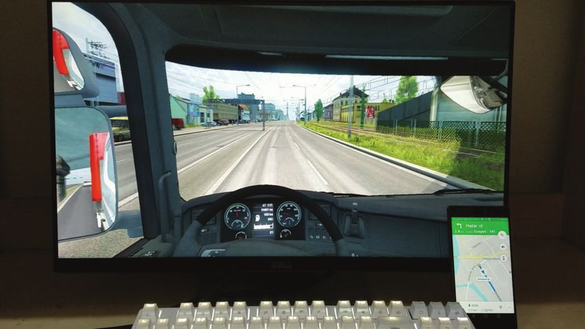
The goal is to manipulate the turn-by-turn navigation and             Real-world Driving Test.         We implemented the al-
guide a victim to a wrong destination without being no-               gorithm and tested it by attacking our own car in a real-
ticed. The key intuition is that users are more likely to             world driving test. We have taken careful protection to
rely on GPS services when navigating in unfamiliar ar-                ensure research ethics (e.g., experiments after midnight
eas (confirmed via user study). In addition, most naviga-             in suburb areas, appropriate shield and power control).
tion systems display the “first-person” view which forces             We demonstrate the feasibility of the attack to trigger the
users to focus on the current road and the next turn. To              target navigation instructions in real-time while the vic-
these ends, if an attacker identifies an attacking route that         tim (the author) is driving.
mimics the shape of the route displayed on the map, then              User Study.         Finally, we examine the attack feasi-
it is possible to trigger navigation instructions that are            bility with users (non-authors) in the loop. Due to the
consistent with the physical environment (e.g., triggering            risk of attacking real cars, we instead perform a decep-
the “turning right” prompt only when there is an actual               tive experiment using a driving simulator. We customize
right-turn ahead) to avoid alerting users.                            the driving simulator to load a high-resolution 3D street
   To understand the attack feasibility, we take four key             map of real-world cities. We apply deception by phras-
steps1 . First, we implement a GPS spoofer to per-                    ing the study as a “usability test of the driving software”,
form empirical measurements to understand the attack-                 while we perform spoofing attacks during the experiment
ers’ practical constraints and capacities. Second, we de-             (informed consent obtained afterwards). The user study
sign the attacking algorithms and evaluate them based                 (N = 40) was conducted in both the US and China with
on empirical taxi driving traces. Third, we implement                 consistent results. We show the proposed attack is highly
the system and validated it using real-world driving tests            effective: 38 out of 40 participants (95%) follow the nav-
(the attacks are applied to the author’s car, with care-              igation to all the wrong destinations. Based on our re-
ful protections and ethical reviews). Finally, we conduct             sults, we discuss possible solutions moving forward.
“deceptive” user studies to examine the feasibility of the               In summary, our paper makes three key contributions.
attack with other users (non-authors) in the loop and un-
derstand key factors to the success of the attack.                        • We propose a novel attack that manipulates the road
Measurements.        We show that adversaries can build a                   navigation systems stealthily. The proposed algo-
portable spoofer with low costs (about $223), which can                     rithm is extensively evaluated using real-world taxi
easily penetrate the car body to take control of the GPS                    driving traces.
navigation system. Our measurement shows that effec-                      • We implement the attack algorithm and a low-cost
tive spoofing range is 40–50 meters and the target device                   portable GPS spoofer. Real-world measurements and
can consistently latch onto the false signals without los-                  driving tests on the road confirm the attack feasibility.
ing connections. The results suggest that adversaries can                 • We conduct a user study to demonstrate the attack
either place the spoofer inside/under the target car and                    feasibility with human drivers in the loop. The results
remotely control the spoofer, or tailgate the target car in                 provide key insights into how common driving habits
real time to perform spoofing.                                              make users vulnerable.
Stealthy Attacking Algorithm.              To make attack
stealthy, we design searching algorithms that search for                 We hope the results can help to raise the attention in
attacking routes in real-time. The algorithm crafts the               the community to develop practically deployable defense
GPS inputs to the target device such that the triggered               mechanisms (e.g., location verification, signal authenti-
navigation instruction and displayed routes on the map                cation, sensor fusion) to protect the massive GPS device
remain consistent with the physical road network. In                  users and emerging GPS-enabled autonomous systems.
the physical world, the victim who follows the instruc-
tion would be led to a wrong route (or a wrong destina-               2      Background and Threat Model
tion). We evaluate algorithms using trace-driving simu-
lations (600 taxi trips in total) from Manhattan [5] and              In this section, we start by providing the background of
Boston [1]. On average, our algorithm identified 1547                 GPS spoofing attacks and describing the unique chal-
potential attacking routes for each target trip for the at-           lenges in road navigation scenarios.
tacker to choose from. If the attacker aims to endanger
the victim, the algorithm can successfully craft special              Global Positioning System (GPS).        GPS is a space-
attack route that contains wrong-ways for 99.8% of the                based radio navigation system that provides the geolo-
trips. Finally, the algorithm also allows the attacker to             cation and time information. To date, it consists of
pre-define a target destination area to lead the victim to.           31 satellites in medium Earth orbit where each satel-
                                                                      lite is equipped with a synchronized atomic clock. Each
  1 Our   study received the approval from our local IRB (#17-936).   satellite continuously broadcasts GPS information using
Coarse/Acquisition (C/A) code on L1 band at 1575.42            those of the navigation service. The attacker also can-
MHz and encrypted precision (P/Y) code on L2 band at           not modify the navigation services or algorithms (e.g.,
1227.60MHz with 50 bps data rate. P(Y) code is used ex-        on Google Maps servers). In addition, we assume the at-
clusively by authorized U.S. military receivers and C/A        tacker knows the victim’s rough destination area (e.g., a
code is not encrypted for general civilian access.             financial district, a hotel zone) or the checkpoint that the
GPS Spoofing Attacks.             Civilian GPS is vulner-      victim will bypass (e.g., main bridges, tunnels, highway
able to spoofing attacks. GPS spoofing attacks have            entrances). In later sections, we will justify why this as-
two key steps: First, in the takeover step, attacker lures     sumption is reasonable and design our attack to tolerate
the victim GPS receiver to migrate from the legitimate         the inaccurate estimation of the victim’s destination. We
signal to the spoofing signal. The takeover phase can          focus on low-cost methods to launch the attack without
be either brute-forced or smooth. In the former case,          the need for expensive and specialized hardware.
a spoofer simply transmits the false signals at a high            Compared to spoofing a drone or a ship [8, 25, 28, 46,
power, causing the victim to lose track of the satellites      61]., there are unique challenges to manipulate the road
and lock on to the stronger spoofing signals. In contrast,     navigation systems. First, road navigation attack has
smooth takeover begins by transmitting signals synchro-        strict geographical constraints. It is far more challeng-
nized with the original ones and then gradually overpow-       ing to perform GPS spoofing attacks in real-time while
ering the original signal to cause the migration. The ad-      coping with road maps and vehicle speed limits. In ad-
vantage of smooth takeover is the stealthiness since it        dition, human drivers are in the loop of the attack, which
will not generate abnormal jumps in the received sig-          makes a stealthy attack necessary.
nal strength. However, smooth takeover requires special-          The scope of the attack is limited to scenarios where
ized hardware to real-time track and synchronize with the      users heavily rely on the GPS device for navigation. For
original signals at the victim’s location (costly) [26, 41].   example, when a user drives in a very familiar area (e.g.,
Next, in the second step, the attacker can manipulate the      commuting from home to work), the user is not necessar-
GPS receiver by either shifting the signals’ arrival time      ily relying on GPS information to navigate. We primarily
or modifying the navigation messages [41, 46].                 target people who drive in an unfamiliar environment. In
                                                               addition, the attack will be applicable to self-driving cars
                                                               that rely on GPS and the physical-world road conditions
2.1    Threat Model                                            for navigation (instead of the human drivers).
In this paper, we explore a novel attack against road navi-
gation systems by spoofing the GPS inputs. In this attack,
the victim is a driver who uses a GPS navigation system        3   Measurement-driven Feasibility Study
(e.g., a mobile app) while driving on the road. The victim
can also be a person sitting in a GPS-enabled self-driving     We start by performing real-world measurements to un-
car. The attacker spoofs the signals of the victim’s GPS       derstand the constraints of the attacker’s capacity in prac-
receiver to manipulate the routing algorithm of naviga-        tice. The results will help to design the corresponding
tion system. The attacker’s goal is to guide the victim        attacking algorithms in the later sections.
to take a wrong route without alerting the victim (i.e.,       Portable GPS Spoofer.          We implemented a portable
stealthy). The attack can be realized for three purposes.      GPS spoofer to perform controlled experiments. As
                                                               shown in Figure 1. The spoofer consists of four com-
 • Deviating Attack. The attacker aims to guide the            ponents: a HackRF One-based frontend, a Raspberry
   victim to follow a wrong route, but the attacker does       Pi, a portable power source and an antenna. The whole
   not have a specific target destination. In practice, the    spoofer can be placed in a small box and we use a pen
   attacker may detour ambulances or police cars to en-        as a reference to illustrate its small size. HackRF One
   ter a loop route.                                           is a Software Defined Radio (SDR). We connect it to
 • Targeted Deviating Attack. The attacker aims to             an antenna with frequency range between 700 MHz to
   guide the victim to a target destination pre-defined        2700 MHz that covers the civilian GPS band L1 (1575.42
   by the attacker, for example, for ambush, robbery or        MHz). A Raspberry Pi 3B (Quad Core 1.2GHz Broad-
   stealing a self-driving car.                                com BCM2837 64bit CPU, 1GB RAM) is used as a cen-
 • Endangering Attack. The attacker aims to guide the          tral server. It runs an SSH-enabled Raspbian Jessie op-
   victim into a dangerous situation, for example, enter-      erating system with a LAMP stack server. GPS satellite
   ing the wrong way on a highway.                             signals are generated by an open-source software called
                                                               Wireless Attack Launch Box (WALB) [6] running on
In our threat model, the attacker has no access to the         Raspberry Pi. The Raspberry Pi has a cellular network
internal software/hardware of the target GPS device or         connection and supports remote access through SSH (Se-
Distance (m)        10     20     30     40     50     60
A Pen
(for size reference)                                                             Takeover Time (s)   59.2   37.6   41.2   62.4   35.0   -
                                                                                 Failure Rate        0      0      0      0      0.2    1.0
                                                                   Antenna
                                                                      ($3)
                                                                                  Table 1: Average takeover time and the failure rate.
Raspberry Pi
($35)
                                                                             average takeover time. The result shows that the average
                                                           HackRF One SDR
                                                                    ($175)   takeover time is slightly higher from the trunk (48 sec-
Mobile Charger
($10)
                                                                             onds) than that from the backseat (35 seconds), but the
                                                                             difference is minor. Note that the takeover is a one-time
                                                                             effort. Once the fake signal is locked in, the connection
           Figure 1: A low-cost portable GPS spoofer.                        can sustain throughout the attack.

 Spoofer                  Phone    Spoofer                        Phone
                                                                             Two-Car Setting.         Then we test to place the spoofer
                                                       d                     and the smartphone in two different cars, and examine
                                                                             the impact of distance d. We increase d by a step of 10
                                                                             meters and measure the takeover time. Cars remain static
          (a) Same-car Test                  (b) Two-car Test
                                                                             during the measurement. As shown in Table 1, the dis-
                                                                             tance does not significantly impact the takeover time, but
                       Figure 2: Measurement setups.                         it does affect the takeover success rate. When the dis-
cure Shell). By controlling the Raspberry Pi, we can in-                     tance is longer, the takeover is more likely to be unsuc-
ject the real-time GPS location information either manu-                     cessful. The effective spoofing range is 40–50 meters.
ally or using scripts. We use a 10000 mAh power bank                            We performed additional tests to examine the potential
as a power source for the entire system. All the compo-                      blockage effect of other cars on the road. More specifi-
nents are available off-the-shelf. The total cost is about                   cally, we placed the spoofer and the smartphone in two
223 US Dollars ($175+$35+$10+$3).                                            different cars. Between these two cars, we placed three
                                                                             additional cars as the blockage. The result shows the av-
Measurement Setups.          We seek to examine the GPS
                                                                             erage takeover time remains similar (41.2 seconds). To
spoofing range, the takeover time delay, and the poten-
                                                                             further examine the sustainability of the signal lock-in,
tial blockage effect from the car body. Before and during
                                                                             we fix the location of the spoofer’s car, and let the vic-
the measurements, we have taken active steps to ensure
                                                                             tim’s car drive in circles (about 10 mph) while keeping
the research ethics and legality. First, the measurement
                                                                             a distance for 15 meters. After driving non-stop for 15
was exclusively conducted in China. We obtained a tem-
                                                                             minutes, we did not observe any disconnections, which
porary legal permission from the local radio regulation
                                                                             confirms the sustainability. Overall, the results demon-
authority in Chengdu, China for conducting the exper-
                                                                             strate the possibility of performing the GPS spoofing at-
iments. Second, we performed the measurements in a
                                                                             tack in practice.
large outdoor parking lot after midnight when there were
no people or cars around (with the permission). Third,
we have carefully tested the GPS signal strength at the                      4      GPS Spoofing Attack Method
edge of the parking lot to make sure the signals did not
affect the outside areas.                                                    The measurement results demonstrate the initial feasibil-
   Our measurement focuses on two possible attacking                         ity, and the next question is how to make the attack more
cases to spoof the GPS device in a moving car (Figure 2).                    stealthy. Intuitively, if the attacker randomly changes the
First, the attacker can place the small spoofer in victim’s                  GPS information of the navigation device, the driver can
car or stick the spoofer under the car. The attacker then                    easily notice the inconsistency between the routing in-
can remotely login to the spoofer via SSH to perform                         formation and physical road condition. For example, the
the attack through a cellular connection. Second, if the                     spoofed GPS location may trigger the navigation system
spoofer cannot be attached to the victim’s car, then the                     to instruct a “left turn”, but there is no way to turn left
attacker may tailgate the victim’s car by driving or flying                  on the actual road. In order to make the driver believe
a drone that carries the spoofer.                                            he is driving on the original route, the key is to find a
Same-Car Setting.      In the same car setting, we place                     virtual route that mimics the shapes of the real roads. In
the smartphone (XIAOMI MIX2 with Android 8.0) as                             this way, it is possible for the navigation instructions to
the victim GPS device in the dashboard area. Then we                         remain consistent with the physical world. Another con-
place the spoofer under the backseat, or in the trunk. At                    tributing factor is that navigation systems typically dis-
each position, we SSH the spoofer to take over the GPS                       play the first person view. The driver does not see the
lock of the phone. We repeat 10 times and calculate the                      whole route, but instead, focuses on the current route and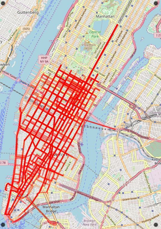
(a) Original navigation route Γ : P → D       (b) Ghost location B                     (c) Actual path of the victim A → C

Figure 3: An attack example: the victim’s original navigation route is P → D; At location A, the spoofer sets the GPS
to a ghost location B which forces the navigation system to generate a new route B → D. Following the turn-by-turn
navigation, the victim actually travels from A to C in the physical world.

the next turn, which is likely to increase the attacker’s          Symbol           Definition
                                                                   G                A geographic area.
chance of success.                                                 R = {ri }        Road segments set.
                                                                   C = {ci }        Road segment connection set. ci = (ri , ri+1 ).
                                                                   L = {li }        Road segment length set. li = |ri |.
                                                                   Φ = {φi }                                     φi = φ(ri , ri+1 ).
                                                                                    Connection turning angle set.
4.1     The Walk-through Example                                   S                The merged segment Sk = ri , ...ri+ j .
                                                                   P, D, Γ          Starting point, destination, navigation route.
                                                                   Γo , Γg , Γv     Original route, ghost route, victim route.
The victim is a traveler to the New York City who is not           Loca , Locg      actual location, ghost location.
familiar with the area and thus relies on a GPS app to             Ωdri f tDis      Max. drifted distance between Locg and Loca .
navigate. Figure 3a shows the victim is driving from               vg , va          Ghost speed, actual speed.
                                                                   Ωspeed           Max. speed scale factor |(vg − va )|/va ≤ Ωspeed .
Hamilton Park in New Jersey (P) to Empire State Build-
ing in Manhattan (D). Assume that an attacker takes over                          Table 2: Notation and definition.
the victim’s GPS receiver at the exit of the Lincoln Tun-
nel (A) as shown in Figure 3c. The attacker creates false       4.2        Attack Formulation
GPS signals to set the GPS location to a nearby “ghost”
                                                                A successful spoofing attack relies on a careful choice
location B. To cope with the false location drift, the nav-
                                                                of the ghost location B. The ghost route B → D should
igation system will recalculate a new route between B
                                                                fit the road map starting from A. In addition, the ghost
and D. We call the new route ghost route. On the phys-
                                                                location B should be close to A so that there will not be an
ical road, the victim is still at location A and starts to
                                                                obvious location change on the navigation map screen.
follow the turn-by-turn navigation from the app. At the
                                                                In the following, we describe our attack objectives and
same time, the navigation app is constantly receiving the
                                                                constraints. Key notations are listed in Table 2.
spoofed GPS signals. Eventually, the victim will end up
at a different place C. Note that the shape of the B → D        Road Model.           As shown in Figure 4, a geographic
route is similar with that of the A → C route. Depending        area G is represented by a set of road segments and
on the purpose of the attack, the attacker may pre-define       connection points. R is a set of road segments, and
the target destination C or simply aims to divert the vic-      C = {ci = (ri , ri+1 )} is a set of connection points. Road
tim from arriving the original destination D.                   segments are inter-connected through connection points.
   In practice, when the attacker changed the GPS in-           L defines road segment length. Φ quantifies a connection
formation from A to B, it may or may not trigger the            point’s turning angle. More specifically, φi = φ (ri , ri+1 ),
“recalculating” voice prompt in the navigation system.          φi ∈ [−π, π). We use the counterclockwise convention to
This depends on where B is positioned. If B still remains       calculate the angle [4]. φi > 0 and φi < 0 indicate a left
on the original route (but at a different location from A),     and right turn respectively.
then there will be no voice prompt. Otherwise, the voice        Navigation Route.              Given a starting point and a des-
prompt could be triggered. This turns out to be less of         tination point, a navigation route Γ is calculated by the
a problem. Our user study (Section 7) shows that users          navigation system represented by road segments: Γ =
often encounter inaccurate GPS positioning (e.g., urban         (r1 , r2 , ..., rn ). In practice, navigation systems typically
canyon effect in big cities) and don’t treat the one-time       tell people to keep driving along the road crossing mul-
“recalculating” as an anomaly.                                  tiple segments before a turn is required. To this end, we
search. For any target geographic area, we construct the
                                                                      road network from public map data. This is a one-time
                    r1       c1   r2   c2                             effort and can be computed offline. In our study, we use
                                                                      the data from OpenStreetMap to build a road network
             S1 = [r1, r2]             r3
             S2 = [r3]                                                G. Based on the graph, we introduce two algorithms to
                                                                      search the attack routes. The algorithms will return a
                                                                      list of potential attack-launching positions and the corre-
              Figure 4: Road model example.
                                                                      sponding victim routes. Using the searching algorithms,
                                                                      the attacker can also specify a target destination (area) to
further merge adjacent road segments. If the turning an-              divert the victim to.
gle at connection point (ri , ri+1 ) is below a certain thresh-
old θ (say 30◦ ), these two road segments can be merged.
After merging such road segments, the navigation route                5.1    Basic Attack Design
is rewritten as Γ = (S1 , S2 , ..., Sm ).
   Consider a victim is following an original route Γo                Given graph G, victim’s current location Loca , destina-
to a destination D. At some point, an attacker launches               tion D and constraints Ω, we design a basic search algo-
the spoofing attack to change the victim’s GPS from its               rithm for the ghost locations and victim routes. Before
actual location Loca to a nearby ghost location Locg .                introducing the algorithm, we clarify on a few assump-
This will trigger the navigation system to recalculate                tions. First, given a starting point and a destination, the
a new route from Locg to D as the ghost route Γg =                    attacker needs to compute a navigation route Γ similar
(Sg1 , Sg2 , ..., Sgm ). Consequently, the victim will follow         to what the victim has. by querying the navigation ser-
navigation instructions from Γg and will end up travers-              vice that the victim is using (e.g., Google Maps APIs). In
ing a victim route Γv = (Sv1 , Sv2 , ..., Svm ). In our attack, Γv    addition, the attacker knows the victim’s actual location
should match Γg in terms of road segments and connec-                 Loca . For the same-car setting (e.g., spoofer is attached
tions. Note that Γv might contain wrong-way segments                  under the victim car), our spoofer is able to tell the fake
(if Svi ’s direction is against the traffic) or loops (if Sv has      GPS signals and the real signals apart, and send the vic-
the same starting and ending point).                                  tim’s actual location back to the attacker. For the tailgat-
                                                                      ing model, the victim is within the sight of the attacker,
Attack Objective.                Given the victim’s current lo-       and thus Loca is known.
cation Loca and destination D, the attack AT K aims                      Regarding the victim’s destination D, it is not neces-
to identify feasible victim routes and the associated                 sarily the final destination. It can be simply a rough area
ghost location Locg and ghost route Γg . We de-                       (e.g., financial district, hotel zone) or a location check-
fine O = AT K(G, D, Loca ) = {o1 , o2 , ..., ok }, where oi =         point (e.g., main bridges, tunnels, highway entrances)
(Γvi , Γg i , Locg i ) such that Γvi matches Γg i . If the attacker   that the victim will bypass. The intuition is simple: for
aims to divert the victim to a pre-defined destination area           two nearby destinations, the navigation system will re-
C, then the attacker only needs to search the oi where Γvi            turn two routes whose early portions are similar (or even
bypasses C.                                                           identical). With an estimated D, the attacker can generate
Constraints.             The constraint Ω includes two ele-           a valid ghost route to match the early portion of the vic-
ments. (1) Location drift constraint Ωdri f tDis which de-            tim’s route, which is sufficient to trigger the fake turn-by-
fines the maximum drifted distance between Locg and                   turn navigation instructions. In practice, attackers may
Loca at the beginning of the attack, i.e., ||Locg − Loca || ≤         obtain D from different channels, such as the target user’s
Ωdri f tDis . This is to avoid obvious location change on the         social media location check-ins, destination broadcasting
navigation map screen. (2) Speed scale factor constraint              in taxi-hailing services, and identifying the checkpoints
Ωspeed that limits the ghost speed vg within a reasonable             that the user must traverse (e.g., the Lincoln Tunnel en-
range, i.e., |(vg − va )|/va ≤ Ωspeed . The above practical           trance when traveling between New Jersey and Manhat-
constraints can be set to different values by attackers in            tan). Technically, attackers can also probe the victim’s
different situations, e.g., depending on the awareness of             destination area by sequentially drifting the ghost loca-
the human users and the navigation system.                            tion and observing the reactive movements of the victim,
                                                                      which has shown to be feasible [46].
                                                                         As illustrated by Algorithm 1, the basic algorithm be-
5    Detailed Attack Algorithm Design                                 gins by selecting a ghost location Locg from all the con-
                                                                      nection points within the distance bound Ωdri f tDis from
Next, we describe the detailed design of our attack al-               the actual location Loca . Then, a ghost navigation route
gorithm. The attack algorithm contains two key com-                   Γg = (Sg1 , Sg2 , ..., Sgm ) from the ghost location to the des-
ponents: road network construction and attack route                   tination is calculated. In order to find as many victim
Input: G, D, Loca , Ωdri f tDis , Ωspeed                                       Input: G, D, Ωdri f tDis , Ωspeed , O0 , I, attack goal
  Output: O = {o1 , o2 , ..., oK }, oi = (Γv , Γg , Locg )i                      Output: Oi , where i = 1, 2, ..., I − 1
   1: Initialization: O ← 0/                                                      1: Initialization: carryover Γv ← 0,     / carryover Γg ← 0,
                                                                                                                                            /
   2: Preprocessing: Find all candidate ghost current locations                      Oi ← 0, / i = 1, 2, ..., I
      {Locg1 , Locg2 , ..., LocgN } within Ωdri f tDis distance from Loca         2: for i = 1 to I − 1 do
   3: for i = 1 to N do                                                           3:    if attack goal has been achieved then
   4:    Γg = (Sg1 , Sg2 , ..., Sgm ), where Γg is obtained through an API        4:        return
         getNavigationRoute(G, Locgi , D)                                         5:    end if
   5:    U0 = {[rac ]}, where Loca ∈ rac                                          6:    U1 ,U2 , ...,Um ← Oi−1
   6:    U1 ,U2 , ...,Um ← 0/                                                     7:    for j = 1 to m do
   7:    for j = 1 to m do                                                        8:        if U j = 0/ then
   8:        if U j−1 == 0/ then                                                  9:             break
   9:            break                                                           10:         end if
  10:         end if                                                             11:         for u in U j do
  11:         for u ∈ U j−1 do                                                   12:             Γg u ← Oi−1 [u]
  12:            v ← u.end point                                                 13:             for k = start j to end j do
  13:            for s ∈ segments with starting point of v do                    14:                 Append basic attack(G, D, Γg u [k]) to Oi
  14:                if s has passed the search criteria then                    15:                 Append Γg u [: k] to carryover Γg [u]
  15:                    Append u.append(s) to U j                               16:                 Append Γvu [: k̂] to carryover Γv [u]
  16:                end if                                                      17:             end for
  17:            end for                                                         18:         end for
  18:         end for                                                            19:     end for
  19:     end for                                                                20:     Save (Oi , carryover Γv , carryover Γg )
  20: end for                                                                    21: end for
  21: return O                                                                   22: return
       ALGORITHM 1: Basic attack algorithm                                          ALGORITHM 2: Iterative attack algorithm

routes as possible, we traverse the graph from the actual                    searching new routes as the victim moves. As shown
location via an m-depth breadth-first search. We keep                        in Algorithm 2, for each iteration, we first check if the
the candidate routes that satisfy the following criteria at                  attack goal has been achieved. If not, we create another
every step:                                                                  location shift on the new ghost route segments from the
                                                                             previous iteration, and apply the basic searching algo-
 • Turn Pattern Matching: To make sure the navigation                        rithm. The attacker goal can be “reaching a pre-defined
   instructions of the ghost route can be applied to the                     destination” or “entering a wrong way”, which helps to
   victim route, we need to match the turn patterns of                       terminate the searching early.
   the two routes: φ (Svi , Svi+1 ) and φ (Sgi , Sgi+1 ) ∈ same
   maneuver instruction category.
 • Segment Length Matching: Given a speed scale fac-                         5.3      Targeted Deviating Attack
   tor Ωspeed , the travel distance of the ghost should be                   With the above searching algorithms, the attacker may
   within (1 ± Ωspeed ) times the victim’s actual travel                     launch the attack by specifying a target destination area.
   distance on each segment, namely, (1−Ωspeed )·Svi ≤                       More specifically, attacker can divide the geographic
   Sgi ≤ (1 + Ωspeed ) · Svi . This guarantees segment                       area into grids (width w) and then pick one of the grids as
   length on the ghost and victim route is similar.                          the target destination. Then the attacker can run the ba-
                                                                             sic or iterative algorithm to compute all the possible vic-
   In the worst case, the computational complexity is ex-
                                                                             tim routes and identify those that bypass the pre-selected
ponential to the number of road segments connected by
                                                                             grid. The attacker can terminate the searching algorithm
one intersection. However, thanks to the searching crite-
                                                                             earlier once a victim route hits the destination grid. In-
ria, the unqualified victim routes can be terminated in the
                                                                             tuitively, the success of the attack depends on the road
very early stage.
                                                                             map of the city and the size of the grid (w). There is
                                                                             also a limit on how far away the target destination can be
5.2    Iterative Attack Design                                               set given the condition of the original route. We provide
                                                                             detailed evaluations in the next section.
In basic attack, the attacker only shifts the GPS position
once from Loca to Locg . Here, we propose an itera-
tive attack, which allows the attacker to create multiple                    6     Attack Evaluation
drifts at different locations, while the victim is driving.
By iteratively applying the basic attack algorithm, the                      Next, we evaluate the proposed algorithms using both
attack performance can be significantly improved since                       trace-driven simulations and real-world driving test. Our
partially matched victim-ghost routes can be used for                        simulation is based on empirical driving traces collected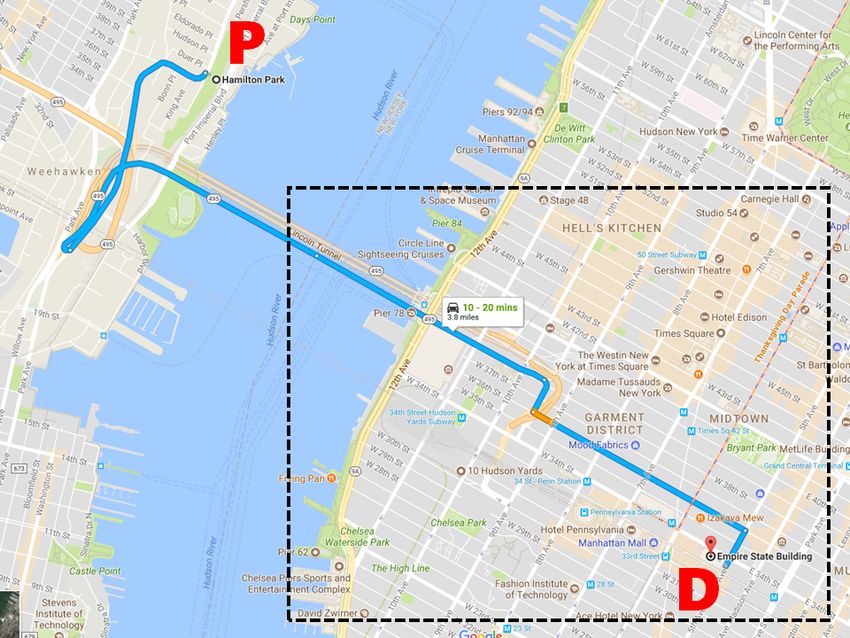
from Manhattan and Boston. Given different attack                 6.2    Evaluation Results
goals, we seek to understand how well the algorithms can
identify the qualified ghost routes and ghost locations.          The performance metric depends on the specific goal of
Then we implement algorithms and conduct real-world               the attacker. Recall in our threat model (Section 2.1),
driving tests to validate the attack feasibility in real-time.    we defined three types of attacks which need different
                                                                  evaluation metrics. Below, our metrics are all based on
                                                                  each of the taxi trips (per-trip metric).
                                                                  Deviating Attack.               If the attacker simply aims to
                                                                  divert the victim from reaching the original destination,
6.1    Simulation Experiments                                     the evaluation metric will focus on the number of victim
                                                                  routes available to the attacker, and the diverted distance
Our attack is more suitable to run in the cities where the        for each road segment on victim routes. More specifi-
road networks are dense. We use the maps of Manhattan             cally, given road segment rv and the original navigation
(NY) and Boston (MA) since the two cities have differ-            route Γo = (r1 , r2 , ..., rn ), the diverted distance for rv is
ent road networks [39] to test our algorithm under differ-        calculated as min {||rv − ri ||}, where ||rv − ri || is the
                                                                                 i=1,2,...,n
ent road conditions. For example, Manhattan has more              distance between two road segments. By running the ba-
regular grids with a 17.8◦ standard deviation of turn an-         sic algorithm, we successfully identify at least one vic-
gles, while Boston has more curvy roads (20.5◦ standard           tim route for all the 600 taxi trips. On average, each
deviation). In addition, Manhattan has a lower road seg-          trip has 335 qualified victim routes, indicating a wide
ment density (51 segments/km2 ) compared with that of             range of attack opportunities. The iterative algorithm (it-
Boston (227 segments/km2 ). We construct the road net-            eration i = 2) identified many more victim routes (3,507
work based on the OpenStreetMap database [39].                    routes per trip). Note that for BOS-I, the results are based
                                                                  on 260 trips with distance capped at 6000m. Figure 5a
Driving Trace Dataset.       To examine the attack per-
                                                                  shows average diverted distance per trip. Again, the iter-
formance on realistic driving trips, we obtain taxi trip
                                                                  ative algorithm is able to identify victim routes that are
datasets from NYC Taxi and Limousine Commission
                                                                  further away from the victim’s original routes. On aver-
(TLC) [5] and the Boston taxi trace dataset used by MIT
                                                                  age, about 40% of the trips can be diverted 500 meters
Challenge [1]. We randomly select 600 real-world taxi
                                                                  away.
trips (300 per city). These traces cover the large area
and various road types (visualization is in Appendix-A).             One specific goal of the Deviating Attack could be
The average length of the routes is 900m in Manhattan             delaying the victim’s trip by leading the victim to loop
(MAN) and 2000m in Boston (BOS).                                  routes. Given a taxi trip, we examine whether there ex-
                                                                  ists a victim route that contains a loop. Using the basic
Evaluation Configurations.           For each taxi trip, we       algorithm, we find at least one loop victim route for 256
exhaustively run the search algorithm at each road seg-           out of 300 (85.33%) taxi trips in Manhattan, and 294 out
ment to identify all the possible attack locations (and the       of 300 (98%) trips in Boston.
corresponding ghost locations and victim routes). This            Targeted Deviating Attack.           If the attacker aims to
provides a “ground-truth” on the possible attack options          divert the user to a pre-defined location, the evaluation
available to the attacker. Then we discuss how these op-          metric will focus on hit rate. For a given taxi trip, the
tions meet the attacker’s goals.                                  hit rate reflects how likely a victim route can bypass the
   For constraint parameters, we set the maximum drift            attacker-defined destination to achieve targeted diverting.
distance Ωdri f tDis = 400m. A measurement study shows            Given a taxi trip, we first circle an area around the taxi
that a GPS drift of less than 400m is common during ac-           route as the considered attack area. The area is of a sim-
tive driving [10]. In addition, given the speed limits in         ilar shape of the taxi route with a radius of r (i.e., any
the two cities are 25 to 30 mph, we set Ωspeed = 0.2 as-          location inside this area has a distance shorter than r to
suming a 5–6 mph speed offset is unnoticeable. For iter-          the taxi route). We divide the area into grids (width w).
ative attack, we run two iterations as a comparison with          The attacker can pick a grid inside the area as the target
the basic attack. Our algorithm also requires calculating         destination. Hit rate is the ratio of the grids that the vic-
the “turning angle” to compare the shape of the roads.            tim can be diverted to over all the grids in the attack area.
We follow Waze’s standard [7] to identify the continu-            An illustration is available in Appendix-B.
ous road ([−30◦ , 30◦ ]]), left/right-turn ([30◦ , 170◦ ]), and      Figure 5b shows the hit rate of the basic attack. We set
U-turn ([170◦ , 180◦ ]). We implement the algorithms in           the grid size as w=500m and then vary the radius r of the
Python, and run the evaluation on a server with a 192GB           considered area. The result shows that we can achieve
RAM and 24 cores.                                                 about 70%, 47%, 20% median hit rate in Manhattan with
1 1 1
BOS-B
0.8 MAN-B 0.8 0.8
MAN-I
BOS-I
0.6 0.6 0.6
CDF
CDF
CDF
B2000
B2000
0.4 0.4 0.4 M2000
M2000
B1000
B1000
M1000
0.2 0.2 M1000 0.2 M500
B500
B500
M500
0 0 0
0 500 1000 1500 0 0.2 0.4 0.6 0.8 1 0 0.2 0.4 0.6 0.8 1
Average diverted distance (m) Hit rate (grid size = 500m) Hit rate (grid size = 200m)
(a) Avg. diverted distance (b) Hit rate (grid size=500m, basic attack) (c) Hit rate (grid size= 200m, basic attack)
1 1 1
MAN-B B1000
0.8 0.8 BOS-B 0.8 M1000
MAN-I
BOS-I
B500
0.6 0.6 0.6 M500
CDF
CDF
CDF
M2000-B B200
0.4 M1000-B 0.4 0.4 M200
M2000-I
0.2 M500-B 0.2 0.2
M1000-I
M500-I
0 0 0
0 0.2 0.4 0.6 0.8 1 0 500 1000 1500 0 0.2 0.4 0.6 0.8 1
Hit rate (grid size = 200m) # of targeted destinations Average overlap rate per route
(d) Hit rate (grid size= 200m, iterative attack) (e) # of Diverted destinations (f) Overlap rate: estimated vs. true routes
Figure 5: Attack results in Manhattan (MAN) and Boston (BOS). B = Basic Attack; I = Iterative Attack; M500 =
Manhattan with a 500m grid size; B500 = Boston with a 500m grid size.
r= 500m, 1000m, and 2000m respectively. This indicates Boston vs. Manhattan. Boston has denser road net-
that even a randomly selected destination grid is highly works and irregular road shapes. Manhattan has a sparser
likely to be reachable. No surprisingly, victim routes get and grid-like road network. The road network features
sparser when it is further away from the original route. affect the attack performance. As shown in Figure 5b and
Note that even with 20% hit rate in 2000m range, if the Figure 5c, the smaller grid size helps Boston to reduce
attacker provides three candidate target destination grids, the hit rate deficit against Manhattan, since the dense
the success rate will be higher 1 − (1 − 0.2)3 = 48.8%. road segments in Boston allow us to divert the victim
Comparing Figure 5b and Figure 5c, we show that a to more precise destinations. In addition, since Boston
larger grid leads to a higher hit rate. In practice, attacker has more irregular roads, it is more difficult to search
can use a larger grid if he can tolerate some inaccuracy for a long victim route that matches the ghost route. On
of the target destination i.e, the victim is led to a nearby the contrary, Manhattan’s grid-like road structure yields
area instead of the exact target location. a better match for long victim routes as shown in Fig-
Figure 5d shows that the iterative attack algorithms ure 5a. Our attack works for small cities, but will yield
can significantly increase the hit rate (blue lines) com- fewer options for attackers (validated in our real-world
paring to those of the basic algorithm (red lines). In ad- driving test).
dition, Figure 5e shows that iterative algorithm also sig-
nificantly increases the total number of bypassed grids by Original Destination Estimation. Recall that to run
all the victim routes, i.e. the number of potential target the attack algorithm, the attacker needs some knowledge
destinations for the attacker. about D, the original destination of the victim. Here,
we evaluate the impact of the inaccurate estimation of
Endangering Attack Result. If the attacker aims D. More specifically, given a true D, we randomly set
to endanger the victim, then we focus on the wrong-way an estimated D0 that is within 200m, 500m or 1000m.
rate. Given a taxi trip, we aim to find at least one victim Using D0 , we generate the estimated route, and then cal-
route that contains a wrong way segment. The basic al- culate the overlapped portion with the original route. As
gorithm identified a wrong-way victim route for 599 out shown in Figure 5f, even if the estimated destination is
of the 600 taxi trips (99.8%). Notably, 90.4% of trips not accurate, there are enough overlapped segments (in
have the victim routes that contain a highway type of the beginning) that can help to generate the victim routes.
wrong way segment, which incurs real danger. For example, even with 1000m error, the attacker can di-
tion, there is another -42.41 dB free space propagation
                                                               loss at a two-meter distance. This means, beyond two
                                                               meters away from the car, the signal strength is already
                                                               very weak (about -127.41 dBm), which cannot take the
                                                               lock of any GPS devices.
                                                                  In total, we tested on two different routes as shown
                                                               in Figure 6. In both screenshots, lines A → D represent
      (a) On-Route Attack          (b) Off-Route Attack        original routes. Blue lines stand for ghost routes, while
                                                               black lines stand for victim routes. A is the user’s ac-
Figure 6: The original routes and victim routes in the         tual location and B is the corresponding ghost location.
real-world driving tests.                                      C is the user’s diverted destination, D is the original des-
                                                               tination. In the first case (Figure 6a), the attacker set the
                                                               ghost location to another location on the original route.
vert the victim using the first half of the ghost navigation   Our test showed that this indeed can avoid triggering the
route (medium 0.5 overlap rate).                               “re-calculating” voice prompt. The route took nine min-
Computation Time Delay.          The ghost route search-       utes and the driver was successfully diverted to the pre-
ing can be completed within milliseconds for the basic         defined location 2.1 kilometers away from the original
attack. The average searching time for one ghost lo-           destination. In the second case (Figure 6b), the attacker
cation candidate is 0.2ms in Manhattan and 0.3ms in            set the ghost location off the original route, which trig-
Boston. The iterative attack takes a longer but accept-        gered a “re-calculating” voice prompt. This time, the
able time: 0.13s in Manhattan and 0.32s in Boston. Note        driver drove five minutes and was diverted 2.5 kilometers
that attacker can always pre-compute the route (within a       away. In both cases, the smartphone was locked to the
minute) before the victim arrives the attack location.         spoofed signal without dropping once. The sequences
                                                               of fake locations were fed to the phone smoothly with
                                                               a 10Hz update frequency. Despite the potential cross-
6.3    Real-world Driving Tests                                checks of heading and filters embedded in Google Maps,
We implemented the full attack algorithm and validated         the navigation instructions were triggered in time.
the feasibility through real-world driving tests. Two au-
thors performed the same-car attack using our own car.         7     Attacks with Human in the Loop
One author acted as the driver (victim) who strictly fol-
lowed the navigation instructions from the Google Maps         Next, we examine how stealthy the attack can be to hu-
(v9.72.2) running on the phone (XIAOMI MIX2 with               man drivers (victims) through a user study. As previously
Android 8.0 and HUAWEI P8 with Android 6.0). The               stated, the attack focuses on people who drive in the un-
other author sat on the backseat to operate the spoofer        familiar locations because they would be more likely to
and ran the attack algorithm on a laptop. As previously        rely on the GPS navigation (instead of their own knowl-
stated, the spoofer can tell apart the fake GPS signals        edge of the roads). We will also check the validity of
with the real ones, and thus the attacker knows the true       this assumption in the user study. Our study cannot in-
location of the victim. The goal of the real-world driving     volve attacking human subjects when they drive real cars
tests is to examine if the spoofer can trigger the fake nav-   due to safety implications. Instead, we conduct a de-
igation instruction in real-time right before users need to    ceptive user study in a simulated environment using a
make a navigation decision.                                    customized driving simulator. Our study received the ap-
   Similar as early measurements, we obtained a legal          proval of our local IRB (#17-936).
permission from the local radio regulation authority, and
conducted the experiments exclusively in China. In addi-
                                                               7.1    User Study Methodology
tion, we have taken active steps to make sure the spoof-
ing signals did not affect innocent users or cars. More        Our user study examines three high-level research ques-
specifically, we performed our measurements in a sub-          tions. R1: how do users use GPS navigation systems in
urb area after midnight when there were almost no other        practice? R2: under what conditions is the GPS spoof-
cars on the road. To minimize the impact of the spoof-         ing attack more likely to deceive users successfully? R3:
ing signals, we reduce the transmit power of the spoofer       what are the user perceptions towards the GPS spoofing
to the minimum (-40 dBm) and then use attenuators (30          attack? We explore the answers with three key steps: pre-
dB) to reduce the signal strength after locking in. The        study survey, driving tests, and post-study interview. To
metal structure of the car also acts as a shield to contain    avoid alerting the participants, we frame the study with a
the spoofing signals (about 15 dB attenuation). In addi-       non-security purpose, stating that the study is to test the
(a) Experiment Setups (b) ETS II Game View (c) Google Street View
Figure 7: User study setups; The ETS II Game View is comparable to the Google Street View at the same location.
usability of our simulation software. We debrief users
after the driving test to obtain the informed consent. The
study takes about 50 minutes and we compensate each
participant $10.
Pre-study Survey. The survey asks two questions:
(1) how often do you use GPS navigation services when
driving in familiar locations (e.g., home and work) and
(a) Original Route (b) Victim Route
unfamiliar locations (e.g., visiting a new city). (2) what
information provided by the navigation service do you Figure 8: The original and victim route for the user study.
primarily rely on during driving?
Driving Tests. To simulate a realistic driving sce-
nario, we build a simulator by modifying a popular driv- legal reasons, we cannot directly spoof the GPS signal
ing simulation game “Euro Truck Simulator II” (ETS of the smartphone. Instead, the smartphone runs a dedi-
II) [2]. We use ETS II for three reasons. First, the game cated app (developed by us) to fetch GPS sequences from
presents the first-person view with realistic vehicle inte- a server. The server reads the GPS information from the
rior and dashboard. In addition to the front view, the par- driving simulator in real time and generates fake loca-
ticipant can easily move the view-angle (to see through tions for the smartphone. In this way, we can directly
the passenger window and the backseat) by moving the manipulate the GPS read of the smartphone for the user
cursor. This provides a wide view range to the partic- study.
ipant. Second, the simulator can load real-world maps To examine user reactions to the attack, we assign
where the 3D street view mimics the reality. Figure 7b each participant driving tasks. The participants will drive
and Figure 7c show the side-by-side companion of the to deliver packages to a given destination following the
game view (of a 3:1 map) and the actual street view (from navigation of Google Maps. Figure 8 shows the driving
Google Street View) at the same location. Because the routes used in our user study. Figure 8a shows the orig-
street view is rendered in a high-resolution, the street inal route that the participant is supposed to take. Fig-
signs and road names are clearly displayed. Third, the ure 8b shows the route to which the attacker aims to de-
simulator SDK allows us to control the day-and-night tour the participants. This route is chosen because it con-
settings and special weather conditions. We provide a tains a high-way in the victim route, and only local-ways
demo video under this link2 . in the original route. These are the clear discrepancies for
For the driving test, we simulate attacking a victim the victim to recognize. We tune two parameters: driving
who drives in a new city. We display the driver’s view time (day or night) and weather (rainy or clear). The par-
on a 22 inch LED display (1920 x 1200) and load a 3:1 ticipant will deliver the package four times (on the same
map of Budapest in Hungary [3], which is considered an route) in this order: “rainy night”, “clear night”, “rainy
unfamiliar city for our participants. At the same time, we day”, and “clear day”. This order makes it easier to rec-
run Google Maps on an Android smartphone as the nav- ognize the attack in the end than at the beginning. The
igation app. The app provides turn-by-turn navigation, experiment stops whenever the participant recognizes the
and the voice prompt reads the street names. The smart- attack. Note that the attack covers the takeover phase
phone is placed in front of the LED display (near the when the phone loses the GPS signal for a while and then
“dashboard” area) as shown in Figure 7a. For ethical and jumps to a new location.
2 Demo: https://www.dropbox.com/sh/h9zq8dpw6y0w12o/ To help the participants to get familiar with the driving
AABZiKCUOhe44Bu1CtHZzHLta simulator, we spend about 5–10 minutes to let the partic-ipants play with the simulator before the real tests. We sults are in favor of our attack, which is designed to ma- also use the time to train the participants to “think-aloud” nipulate the voice and the visual elements. — expressing their thoughts and actions verbally. Dur- User Reactions to GPS Spoofing Attacks. Our at- ing the real test, we encourage the participants to think- tack has achieved a high successful rate (95%). Out of 40 aloud and record the audio. people, only one U.S. participant and one Chinese partic- Post-study Interview. In the interview, we first de- ipant recognized the attack. The rest 38 participants all brief the participants about the real purpose of the study. finished the four rounds of driving tasks and followed the Second, we ask about their perceptions towards GPS navigation to reach the wrong destinations. spoofing attacks. Third, we let the participants comment Both participants recognized the attack because they on the key differences between using the driving simu- detected certain inconsistency between the navigation in- lator and their real-world driving. The participants can formation and the surrounding environment on the road. withdraw their data at any time and can still receive the The U.S. participant (user#38, m, 18-25, driving
Mechanism                                  $ Cost   Deploy. Overhead    Effectiveness   Robustness
                    Encryption & authentication [29, 64]                  High          High              High          High
     Modif.-based   Ground infrastructures [12, 27, 36, 49, 50]           High          High              High          High
                    GPS receiver hardware [24, 31, 35, 40, 47, 73]       Medium         High              High          High
                    GPS receiver software [32, 35, 47, 48, 55, 63, 65]    Low           Low               Low            Low
                    External location verification [23, 70]               Low           Low               Low            Low
                    Internal sensor fusion [19, 57]                       Low           Low               Low            Low
     Modif.-free
                    Computer vision [13, 42, 69]                          Low           Low             Medium         Unknown
                                       Table 3: Comparison of different countermeasures.

in the loop. The results also point out three types of                   the constraints in government policies, and the signifi-
inconsistencies that are likely to alert users: (1) incon-               cant costs, dedicated ground infrastructures are also un-
sistency between highway and local ways; (2) inconsis-                   likely to be widely deployed.
tent street names; (3) inconsistent landmarks (e.g., gas                    Finally, we can modify the GPS receivers. For ex-
station). More advanced attacks can further avoid the                    ample, the angle-of-arrival of signals can help to esti-
“highway - local way” inconsistency by filtering out such                mate the transmitter’s location for authenticity check.
routes. The other two factors depend on whether the                      This requires a large directional antenna array [35], or
driver has the habit (and has the time) to cross-check                   special moving antenna [47]. Such hardware modi-
the surrounding environment. In addition, our interview                  fications are not applicable to the billions of mobile
reveals that most people have experienced GPS malfunc-                   phones. At the software level, consistency-check algo-
tion in real life, which makes them more tolerable to GPS                rithms can help to detect the side effects of non-smooth
inconsistencies. In addition, since people are more likely               GPS takeover [32, 63, 65]. In addition, the GPS receiver
to rely on visual and voice prompt, it increases the at-                 can also lock on additional satellites [48] or synchronize
tacker’s probability of success. Our study still has limi-               with other GPS receivers [55] to identify spoofing. How-
tations, which are discussed at the end of the paper.                    ever, these methods often suffer from the multi-path ef-
                                                                         fect and are vulnerable to smooth takeovers [26].
8   Discussion and Countermeasures                                       Modification-Free Approaches.              First, location
                                                                         verification can leverage existing GNSS signals (e.g.,
Our study demonstrated the initial feasibility of ma-                    Galileo, GLONASS, Beidou) [23], and wireless network
nipulating the road navigation system through targeted                   signals [70]. These external location verifications help
GPS spoofing. The threat becomes more realistic as                       but cannot stop the attacker completely because civilian
car-makers are adding auto-pilot features so that hu-                    GNSS signals are also unencrypted. The attacker can
man drivers can be less involved (or completely disen-                   perform multi-signal jamming or spoofing against both
gaged) [38]. In the following, we discuss key directions                 signals [26]. Similarly, the network location is based on
of countermeasures.                                                      the MAC address of the WiFi or cell tower ID, which can
   In Table 3, we classify different methods based on                    also be jammed or spoofed [43, 56].
whether (or how much) they require modifications to                         In addition, a navigation system may cross-check the
the existing GPS. Modification-based methods require                     GPS locations with dead reckoning results based on in-
changing either the GPS satellites, ground infrastruc-                   ertial measurement unit (IMU) sensors (e.g., accelerom-
tures, or the GPS receivers. Modification-free methods                   eter, gyroscope, magnetometer) [19, 57]. However, this
typically don’t need to change existing GPS, which make                  method in general suffers from accumulative IMU sensor
them more attractive to be adopted.                                      errors and becomes ineffective as the time drifts.
Modification-Based Approaches.            First, the most ef-            Computer Vision based Location Verification.            We
fective solution is to upgrade the civilian GPS signals to               believe a promising defense direction is to use com-
use the P(Y) code encryption. Researchers also proposed                  puter vision techniques to automatically cross-examine
signal authentication for next-generation GNSS (Global                   the physical-world landmarks and street signs with the
Navigation Satellite System) [29, 64]. However, this ap-                 digital maps. Recall that in our user study, the two partic-
proach is extremely difficult to prevail in a short term,                ipants recognized the attack in a similar way. Given the
given the massive number of civilian GPS devices al-                     proliferation of cameras/LIDARs on mobile devices and
ready shipped and deployed in the short term.                            vehicles, vision-based location verification only requires
   Second, trusted ground infrastructures to help GPS de-                software level upgrade. So far, vision-based techniques
vices to verify the location and related techniques include              can accurately localize vehicles (up to 3m) using visual
trusted verifiers, distance bounding protocols [12, 49],                 odometry and road maps [13, 42]. SLAM (Simultane-
multilateration [50], multi-receiver crowdsourcing [27]                  ous Localization And Mapping) can also localize images
and physical-layer feature checks [36]. However, due to                  based on geo-referenced street view databases [69].
You can also read