FIELD TRIP GUIDES - Geoscience Society of New Zealand 2012 Conference
←
→
Page content transcription
If your browser does not render page correctly, please read the page content below
Geoscience Society of New
                Zealand 2012 Conference

  FIELD TRIP GUIDES

HAMILTON 25 - 28 November 2012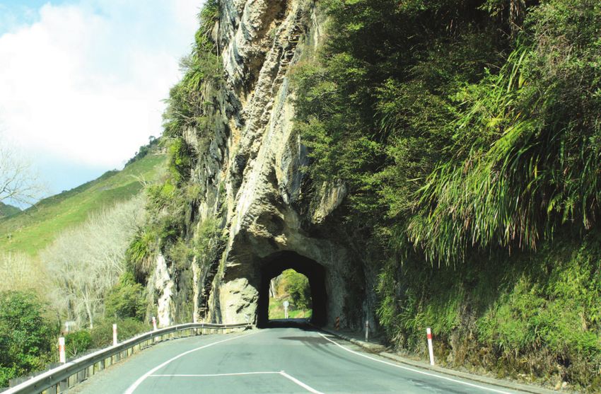
Geosciences 2012
                     HOST Sponsor
                             Department of Earth and Ocean Sciences

                               Faculty of Science and Engineering

                                      Broad Memorial Fund

                     GOLD Sponsors

                    BRONZE Sponsors

NZJGG BBQ Sponsor   TEA BREAK Sponsor        DINNER PRIZES

                       EXHIBITORS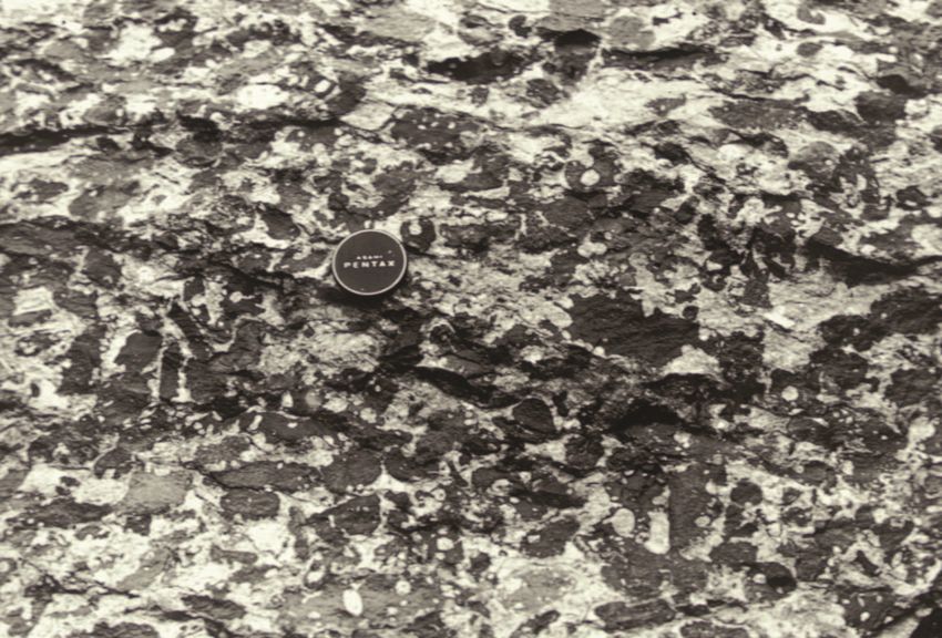
Annual Conference of the Geoscience
                                                    Society of New Zealand

                          Field Trip Guides

                                  Conference Convenor
                            Adrian Pittari (University of Waikato)

                                 Organising Committee
  Roger Briggs, Rochelle Hansen, Chris Hendy, Steve Hood, Peter Kamp, David Lowe, Cam
                       Nelson, Sydney Wright (University of Waikato)

                                     Administration
                          Janet George (Absolutely Organised Ltd)

                                   Symposium Convenors
Peter Almond, Greg Bignall, Carolyn Boulton, Karin Bryan, Hamish Campbell, Martin Crundwell,
   Jennifer Eccles, Susan Ellis, David Hamilton, Peter Kamp, Gert Lube, David Lowe, Vicki
Moon, Nick Mortimer, Adam Munro, Rewi Newnham, Adrian Pittari, Mark Quigley, Andrew Rae,
  Catherine Reid, Martin Reyners, Glenn Vallender, Russ Van Dissen, Jenny Webster-Brown

                                      Field Trip Leaders
Roger Briggs, Mike Hall, Chris Hendy, Peter Kamp, Kerri Lanigan, David Lowe, Vicki Moon, Cam
                       Nelson, David Palmer, Adrian Pittari, Andrew Rae

Photographs on front cover: Maria Lowe (top), Wendy Peel (bottom left)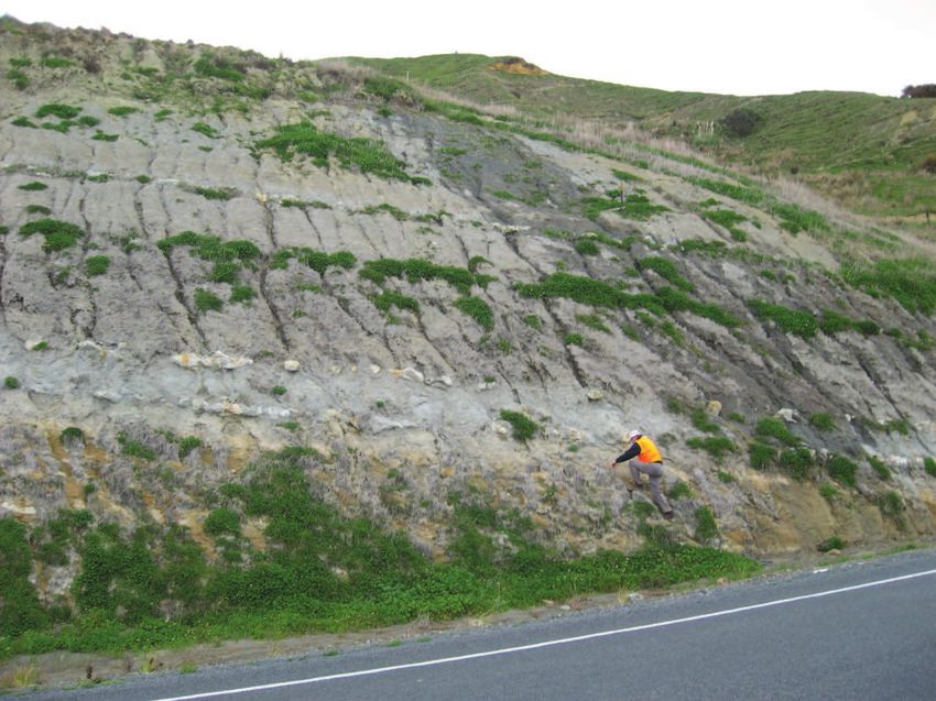
!"#$%$&%'()*+!%,#)"-")".,"#-')#"*,!#/"&0#1)%+#(2%0"#%34

Author, A.N. (2012). Title of Field Trip Guide. In: Pittari, A. (compiler). Field Trip Guides, Geosciences 2012 Conference,
Hamilton, New Zealand. Geoscience Society of New Zealand Miscellaneous Publication 134B. p. x.

ISBN 978-1-877480-26-3
ISSN (print) 2230-4487
ISSN (online) 2230-4495

Geosciences 2012
                Annual Conference
of the Geoscience Society of New Zealand, Hamilton

                       Field Trip 3
          Thursday-Friday 29-30 November 2012

          Oligocene-Miocene sedimentary record,
               eastern Taranaki Basin margin

         Leaders: Cam Nelson and Peter Kamp
                  University of Waikato

                                  Bibliographic reference:
    Nelson, C.S. and Kamp, P.J.J. (2012). Oligocene-Miocene sedimentary record, eastern
     Taranaki Basin margin. In: Pittari, A. (compiler). Fieldtrip Guides, Geosciences 2012
         Conference, Hamilton, New Zealand. Geoscience Society of New Zealand
                           Miscellaneous Publication 134B, 63 p.

    ISBN: 978-1-877480-26-3
    ISSN (print): 2230-4487
    ISSN (online): 2230-4495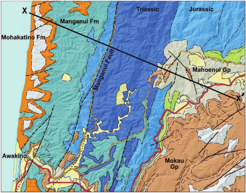
Frontispiece A. Kawau Pa site on the coastline north of the Tongaporutu River mouth (Stop 23, Q18/492697)
affords excellent exposures of light grey hemipelagic mudstone with thin tephra layers and thick-bedded, often
amalgamated, brown fine sandstone of the late Miocene (lower Tongaporutuan, Tt) Mt Messenger Formation.
The upper part of the section shows late Pleistocene Rapanui Formation deposits (beach-dune sediments) asso-
ciated with Marine Isotope Stage 5e (see Stop 17).

Frontispiece B. Awakino Tunnel at the northern end of Awakino Gorge is cut through steeply dipping Orahiri
Limestone (late Oligocene, Duntroonian, Ld) of the Te Kuiti Group (Stop 10, R17/615854).
Awakino Field Guide                  Introduction

1. HEALTH AND SAFETY
PLEASE READ!

Certain hazards will be encountered on this field trip. General information is mentioned below
and some more specific matters are given in Appendix 1. At all times, participants must heed and
observe the warnings and directions of the trip leaders and/or quarry managers.

We expect the weather in late November to be warm and sunny, but participants also need to be
prepared for cooler, wet and/or windy conditions. Sturdy, enclosed, shoes or boot-like footwear
are required and eye protection (e.g. glasses or sunglasses) is desirable. A sunhat and sunscreen
is recommended, as is a waterproof and/or windproof jacket. Participants must carry any person-
al medications for allergic reactions (e.g. insect stings, pollen, food allergies).

An average level of fitness and mobility is required for this trip. Participants must be surefooted
enough to walk up to several hundred metres on farm or bush tracks and along sandy or gravelly
beaches, and be able to walk up and down moderately steep tracks and grassed hilly paddocks
exposing rock outcrops. Underfoot conditions could include beach sands and gravels, gravel or
bush tracks, roadside curbs, grass slopes, wooden walkways and stepped rock outcrops.

Caution must be exercised when examining rocks at the base of natural or quarried or cut cliffs
and banks on roadsides or backing beaches, due to the risk of rock fall from above and, in the
case of road exposures, also from passing traffic. If you hammer rocks, wear eye protection and
pay special heed to the safety of other participants. High-visibility vests will be provided for
participants, and hard hats are also available. A hammer and hand lens will be useful but not
essential, but a camera to record your trip is!

At all quarry sites, high-visibility vests and hard hats must be worn away from the vehicles.

Lunch, including a drink, is provided for both days, but participants may wish to bring some addi-
tional special food items and a water bottle. A food shop stop cannot be guaranteed during the
trip. Overnight accommodation is at the Awakino Hotel or other arranged nearby premises, and
meals will be provided at the hotel.

2. FIELD TRIP SYNOPSIS

A 2-day field trip departing 8 am Thursday 29 November 2012 from Hamilton south to Te Kui-
ti-Piopio-Awakino-Tongaporutu affords a fine north to south transect through examples of the
Mesozoic to Quaternary succession in the Waikato-King Country region bordering the eastern
margin of Taranaki Basin. The trip will view some of the onshore Oligocene and Miocene sedi-
mentary record in the Waikato and King Country basins and comment on how this links into the
offshore parts of eastern Taranaki Basin. Primarily under both local and more distant tectonic
control, we will track the various carbonate and terrigenous (locally volcaniclastic)-dominated
facies associated with marginal marine, shoreline, shelf and slope-to-basin depositional settings,
and consider their stratigraphic architecture and wider sequence stratigraphic context. Visits are
planned along the way to basement greywacke, serpentinite and limestone quarries.

                                              3.3
Route Map & Itinerary Awakino Field Guide
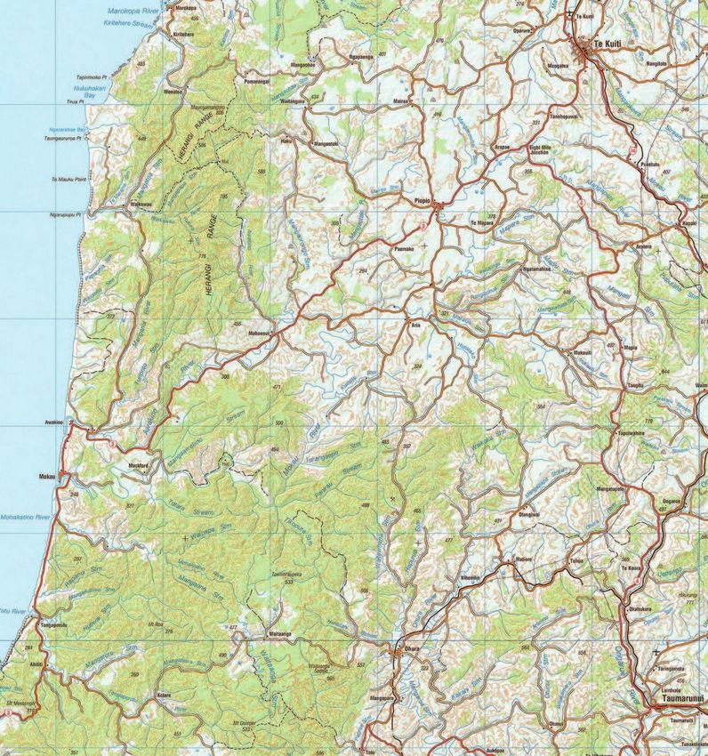
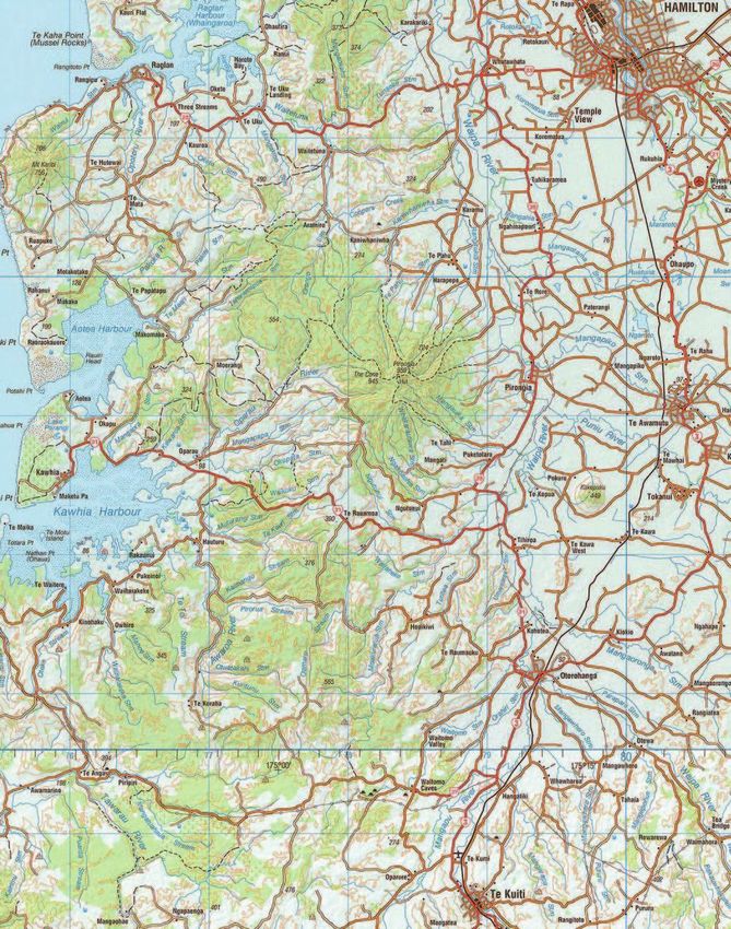
3. ROUTE MAP
The route map and planned stops for the trip are shown on Fig. 1 and listed below. On day 1 we
travel from Hamilton to Awakino, and on day 2 we are in the Awakino-Tongaporutu area before
returning to Hamilton. Several stops should be brief and could become optional depending on
time and weather. Recorded grid references are approximate only and based on the 1:50,000 NZ
260 Topomap Series; the list below also shows in italics the grid reference equivalents for the new
NZTopo50 Series 1:50,000 maps.
Day 1
Stop 1 - Hinuera Formation, Hamilton Airport (S15/151669; BD34/049053 )
Stop 2 - Waipapa terrane greywacke, Tokanui (S15/153405; BE34/051789 )
Stop 3 - Otorohanga Limestone and Mahoenui Gp mudstone, Oparure (S16/915159; BF33/813542)
Stop 4 - Wairere Serpentinite –Dun Mountain-Maitai terrane, Piopio (R17/859932; BF32/758315 )
Stop 5 - Murihiku terrane “greywacke” and Piopio High, Piopio (R17/855003; BF32/754386 )
Stop 6 - Aotea Formation - Orahiri Limestone, Mangaotaki Bridge (R17/761957; BF32/660340 )
Stop 7 - Taumatamaire Formation of Mahoenui Group, Mangaotaki (R17/755946; BF32/654329 )
Stop 8 - Mahoenui depocentre overview, Mahoenui (R17/729924; BF32/628307 )
Stop 9 - Oligocene-early Miocene geology, Awakino Tunnel (R17/618853; BG31/517236 )
Stop 10 - Orahiri Limestone, Awakino Tunnel (R17/615854; BG31/514237 )
Stop 11 - Awakino Limestone Member, Awakino Gorge (R18/591795; BG31/490178 )
Day 2
Stop 12 - Bexley Sandstone, south end Awakino Gorge (R17/559800; BG31/458183 )
Stop 13 - Overview Miocene geology, western end of Ladies Mile (R17/547806; BG31/446189 )
Stop 14 - Bexley Sandstone to Manganui Formation transition (R17/525818; BG31/424201 )
Stop 15 - Manganui/Mangarara/Mohakatino Fms, Awakino Heads (R17/511808; BG31/410191 )
Stop 16 - Mt Messenger Formation, Pahaoa Hill (R18/513799; BG31/412182 )
Stop 17 - Rapanui Formation, Seaview Motor Camp (R18/509794; BG31/408177 )
Stop 18 - Mt Messenger/Mohakatino Fms, Mokau River mouth (R18/510770; BG31/409153 )
Stop 19 - Mt Messenger Fm sandstone, Mohakatino River bridge (R18/505736; BG31/404119 )
Stop 20 - Mt Messenger Fm sandstone, Tongaporutu River mouth (Q18/486642; BG31/385025 )
Stop 21 - Mt Messenger Fm thin-bedded sandstone, Okau Rd (R18/515578; BG31/414961 )
Stop 22 - Otunui Formation and volcaniclastic interbed, Okau Rd (R18/574547; BH31/473930 )
Stop 23 - Mt Messenger Formation, Kawau Pa site (Q18/492697; BG31/391080 )
3.4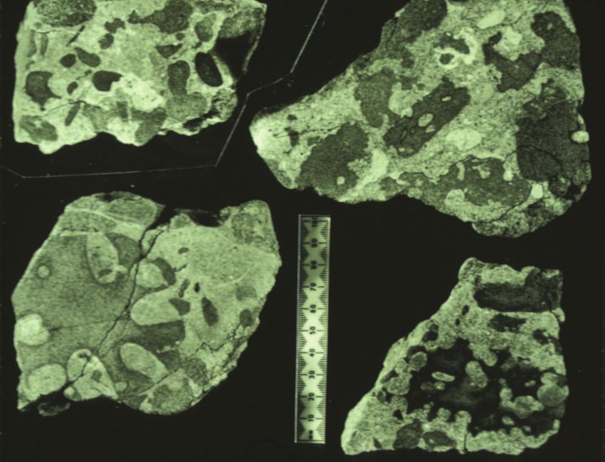
Awakino Field Guide           Background geology

4. BACKGROUND INFORMATION

4.1 Hamilton Basin
Hamilton Basin is an c.30 km wide N-S oriented graben bounded by horst blocks of uplifted Mes-
ozoic basement rocks to the west (Hakarimata Range) and east (Cambridge hills and Rangitoto
Range). The graben is filled by a succession of Oligocene to Holocene sedimentary deposits (Ed-
brooke et al. 2005). Depth to basement in the Basin is up to 1.5-2.0 km (Kear & Schofield 1978).
The capping Pliocene to Holocene volcaniclastic (pumiceous) terrestrial sediments, including oc-
casional pyroclastic flow and airfall units, form the Tauranga Group for which exposures are few,
scattered, and often weathered. The silicic volcanic material forming the bulk of these sediments
was sourced initially from the Coromandel and later the Taupo Volcanic Zone. The thickness of
the Tauranga Group deposits is highly variable, typically from 5-90 m, but occasionally reaches
several 100 m. The prominent low hills within the Hamilton Basin (e.g. the elevated part of Uni-
versity of Waikato campus) are underlain by the older late Pliocene to middle Quaternary volcan-
iclastic sands and tephras of the Tauranga Group (e.g. Puketoka Formation, Karapiro Formation,
Kauroa Ash Formation and Hamilton Ash Formation). The widespread flat surface surrounding
the low hills is the Hinuera Surface, the maximum aggradation level of the ancestral braided
Waikato River system during the late Pleistocene (c.50-15 ka). The alluvial deposits, known as the
Hinuera Formation (Stop 1), consist of up to 90 m of unconsolidated, profusely cross-bedded,
pumiceous and rhyolitic gravelly sands derived from active erosion and silicic volcanism in the
central North Island during the Last Glacial period (Hume et al. 1975). In the Holocene, extensive
(now drained) peat swamps developed on poorly drained parts of the Hinuera Surface, including
the Rukuhia Swamp west of the highway on leaving Hamilton and the Tuatuamoana Swamp
east of the highway near Ohaupo. The evolution of the Hamilton Basin landscape and the past
wanderings of the Waikato River have been fully documented in the recent Geoscience of New
Zealand Guidebook 16 by McCraw (2011).

4.2 King Country Basin (including aspects of bounding Wanganui and Taranaki
Basins)
South of Te Awamutu, Hamilton Basin merges into King Country Basin (Kamp et al. 2004), for-
merly known as North Wanganui Basin. Beyond about the latitude of Hawera in Taranaki, King
Country Basin in turn merges southwards into Wanganui Basin (formerly called South Wanganui
Basin). All these basins pass offshore into eastern Taranaki Basin. Apart from the brief consider-
ation of Hamilton Basin in section 4.1, the remainder of this field trip is entirely within the north-
ern portion of King Country Basin. However, it is relevant at times to relate what we see at the
various stops to the wider central-western North Island geology, especially in regard to possible
major depositional controls on facies types and successions. To this end, the following back-
ground information draws heavily on material appearing in Petroleum Report PR3463 by Kamp
& Vonk (2006), which also provides detailed information about many other useful field trip stops
throughout the wider King Country Basin.

4.2A Geological setting
A simplified geological map of central-western North Island is shown in Fig. 2. Note that the
rocks to be seen on this field trip range upwards from Basement (Mesozoic; blue), Te Kuiti Group
(Oligocene; green), Mahoenui Group (dark grey; early Miocene), Mokau Group (fawn; late ear-
ly Miocene), Otunui Formation (pale brown; middle Miocene), Mohakatino & Moki Formations
(orange; middle Miocene), and Mt Messenger Formation (light grey; early late Miocene). Apart
also from the Urenui and Kiore Formations (light orange; late Miocene) these are the dominant

                                               3.5
Background geology Awakino Field Guide
geological units in the King Country.
Fig. 3 is a structure map of the same region. A Miocene time scale showing the names, sym-
bols and ages of New Zealand Stages is reproduced from Cooper et al. (2004) in Fig. 4. Fig. 5
shows schematically the occurrence of the major Neogene stratigraphic units in each of the King
Country, Wanganui and Taranaki Basins. The eastern margin of Taranaki Basin has traditionally
been marked by the Taranaki Fault (e.g. King & Thrasher 1996). Note, however, in Fig. 2, how the
boundaries of the late Miocene and Pliocene stratigraphic units cross the projected trace of the
Taranaki Fault. This highlights the common geological history the basins have had during the
late Neogene.
The King Country Basin lies to the east of the northern part of Taranaki Basin (Fig. 6). Its south-
ern and common boundary with Wanganui Basin is poorly defined with no obvious structure
between them. It broadly lies within a southward dipping monocline (Wanganui Monocline,
Fig. 3) that reflects progressive southward onlap on to basement, which has been modified by
later uplift and tilting to the south and southwest. For the purposes of defining the boundary
between these basins, the base of the Matemateaonga Formation has been adopted. This marks
the stratigraphic point at which substantial subsidence of basement in the northern part of Wan-
ganui Basin started, with marked southward migration of the shoreline. The eastern margin of
Wanganui Basin is marked by the axial ranges, and the western margin is marked by the offshore
continuation of the Patea-Tongaporutu High and by the D’Urville High (Fig. 3).
4.2B Basement rocks
The Mesozoic basement rocks in central western North Island form parts of three tectonostrati-
graphic terranes. The late Triassic to late Jurassic Murihiku terrane rocks are fossiliferous lithic
sandstones (“greywackes”), siltstones and occasional conglomerates, broadly folded into the Ka-
whia Regional Syncline, beneath the area to the west of Waipa Fault (Fig. 3; Stop 5). To the east
of Waipa Fault is the Waipapa (composite) terrane of mainly highly sheared and faulted Jurassic
volcaniclastic sandstones (greywackes) (Stop 2). The Dun Mt-Maitai terrane, represented at the
surface by a sliver of serpentinite near Piopio, has been intruded along the Waipa Fault (Stop 4);
otherwise it is recognised in the subsurface in western North Island by the linear positive mag-
netic anomaly known as the Junction Magnetic Anomaly (Hatherton 1967).
4.2C Outcrop patterns
Much of the Neogene tectonic development of the region can be read from the geology and
structure maps (Figs. 2, 3). A striking feature of the outcrop pattern in the northern part of Wan-
ganui Basin and the southern part of King Country Basin is the west-east strike of the forma-
tions (Fig. 2). This involves the Mount Messenger Formation through to Nukumaruan (late Pli-
ocene-early Pleistocene) strata (Fig. 5). These units are structurally conformable and dip 2-4°
S or SW. The strike of these beds is normal to the orientation of the plate boundary zone, and
therefore the origin of the bedding attitude is not simply related to upper crustal shortening
driven by plate convergence. Significantly, the distribution of Castlecliffian (middle to late Pleis-
tocene; Figs. 2, 5) strata only are influenced by the occurrence of the axial ranges (Tararua-Rua-
hine Range), suggesting that the uplift of these ranges occurred mainly during the Castlecliffian
to Holocene interval.
In the central and northern parts of King Country Basin the stratigraphic units are Oligocene
(Te Kuiti Group) and early Miocene (Mahoenui and Mokau Groups) in age and have shallow to
3.6Awakino Field Guide Background geology
negligible dip, being influenced more locally by tilting about the Herangi Range/High (Nelson
et al. 1994; Fig. 3). Faults (e.g. Ohura Fault) have roughly NE-SW strikes sympathetic to those de-
fining the Northern Graben in Taranaki Basin and the Taupo Volcanic Zone (Fig. 3). In central
and western parts of Taranaki Peninsula the Urenui Formation through to Tangahoe Mudstone
successions are overlain by Mount Taranaki Quaternary volcanics and volcaniclastic sediments of
the ring-plain (Fig. 2).
4.2D Uplift and erosion of central North Island
The outcrop pattern of central-western North Island reflects long wavelength up-doming of cen-
tral North Island and associated erosion of weakly lithified mudstone and associated lithologies.
Fig. 6 is a map showing the magnitude and pattern of erosion calculated by kriging of estimates
of the amount of erosion determined chiefly from analysis of the bulk density of mudstone cores
(Kamp et al. 2004). There are two sets of bulk density data underpinning the map, including a
DSIR dataset obtained during the 1960s for regional gravity mapping (Reilly 1965) and made
available by the Institute of Geological & Nuclear Sciences Ltd, and a second data set collected as
part of our University of Waikato work, which concentrated on high density sampling in the main
river valleys of Wanganui Basin (Fig. 6).
Fig. 6 is essentially an erosion map as the data underpinning it reflect the amount of exhumation
of the mudstone horizons sampled. The magnitude of erosion varies systematically, increasing
northward from Wanganui Basin into King Country Basin, and eastward from eastern Taranaki
Basin into the King Country region (Fig. 6). The maximum amount of erosion is probably about
2000 m. The zero erosion line offshore is presumed to have formed chiefly by wave planation and
cliff retreat during successive Pleistocene marine transgressions and sea-level highstands, which
also formed the uplifted flights of middle and late Pleistocene terraces in the vicinity of Taranaki
Peninsula. Inland of the coastal zone, fluvial and slope processes acting on weakly lithified mud-
stone and sandstone are likely to have produced the erosion at rates that will have nearly approx-
imated the rock uplift rates. In the Kaimanawa Range and northern Ruahine Range the Neogene
cover rock succession has been almost completely removed and the exhumed basement surface,
which is still evident in places, has been finely dissected (Fig. 6). The material eroded was dis-
persed to the surrounding basins, including northern Taranaki Basin (Giant Foresets Formation),
Wanganui Basin (Rangitikei Supergroup), and Hawke’s Bay Basin (Maungahururu Formation and
Petane Group).
4.2E Stratigraphic units removed
The magnitude of erosion leads to the question of what stratigraphic units were removed. We
consider that these included mainly the Mokau and Mahoenui Groups and the middle Miocene
through Pliocene stratigraphic units involved in the Wanganui Monocline. The former occurrence
of these units as evidenced by the results of analyses of the bulk density of exhumed mudstone
beds, indicates that the King Country Basin was a long-lived marine sedimentary depocentre,
and points to its probable former depositional continuity with northern parts of Wanganui Basin,
and possibly the East Coast Basin during the early Miocene. This has implications for understand-
ing of the Neogene paleogeographic development of central North Island.
4.3 Stratigraphic architecture of the basin fills
We illustrate the stratigraphic architecture of the fills of the three basins in central-western North
3.7Background geology Awakino Field Guide
Island by reference to two cross-sections and related time-stratigraphic panels (Kamp et al.
2004). Fig. 7 shows the lines of these cross-sections in relation to the distribution of the major
stratigraphic units.
4.3A Wanganui Basin to King Country Basin
Fig. 8 illustrates a N-S cross-section through the axis of the Wanganui and King Country Basins
between Parakino-1 well in the south and Ararimu-1 well in the north. It shows the stratigraphic
and structural concordance of the formations and how the slope on the basement surface is sim-
ilar to the dip on the formation contacts. The Wanganui Monocline (Fig. 3), defined from the dip
of Neogene sediments, is a reflection of the subsurface structure on basement. The cross-section
also shows the persistent southward onlap of successive formations on to basement, suggestive
of a north-facing paleoslope prior to later uplift and tilting to the south.
The time-stratigraphic section (Fig. 8) highlights particularly the occurrence of four major Neo-
gene unconformity-bounded sequences (excluding the late Paleogene Te Kuiti Sequence, por-
tions of which will be seen at Stops 3, 6 & 10). The first two are of early Miocene age. The Ma-
hoenui Group comprises massive mudstone (Taumatamaire Formation) and flysch (Taumarunui
Formation) facies (Hay 1967; Nelson & Hume 1977; Topping 1978; Cartwright 2003). The initial
subsidence of the basin containing this succession occurred during the Oligocene (Te Kuiti Se-
quence) and is marked in the south by thin (up to 30 m) coaly incised valley fill deposits, thin
transgressive (onlap) shellbeds, and overlying marine neritic sandstone and mudstone beds
(Pungapunga Formation (new) of the Te Kuiti Group (2nd order) sequence; Cartwright 2003).
A glauconitic mudstone a few dm thick locally at the base of the Mahoenui Sequence marks a
prominent flooding surface. It reflects initial terrigenous sediment starvation associated with
rapid subsidence and flooding of the basin, marked onlap of basement around the margins, and
the establishment of deep-water conditions. This was followed locally by the accumulation of
about 100 m of massive shelf to slope mudstone (Stops 3, 5 & 7) and then by about 1000 m of
redeposited sediments (turbidites) that accumulated at bathyal depths. The Mahoenui Group
is predominantly of Otaian age (Topping 1978). Surprisingly, no regressive slope or shelf facies
have been identified at the top of the Mahoenui Group. Presumably, if they were originally pres-
ent, they were abridged and eroded during a short-lived and marked phase of uplift and erosion
that affected the whole of the Mahoenui depocentre. The Herangi-Tongaporutu High separated
the Mahoenui depocentre from Taranaki Basin. This depocentre was a piggy-back basin being
transported westward during basement overthrusting on the Taranaki and Manganui Faults (Fig.
3). The Taimana Formation and lower parts of the Manganui Formation are stratigraphic equiva-
lents in Taranaki Basin of the Mahoenui Group in the King Country region (see Figs. 11, 12).
The inversion of the Mahoenui depocentre was associated with reverse movement on the Ohura
Fault (Fig. 3). The upthrown block to the east of this fault partly sourced sediments to the area
to the west of the Ohura Fault throughout the rest of the early Miocene (Altonian), where they
formed the Mokau Group/Sequence (Fig. 8). The Mokau Sequence comprises lower transgres-
sive sandstone (Bexley Sandstone; Stop 14), a coal-bearing fluvial and intervening shoreface
succession (Maryville Coal Measures), and an upper regressive shoreface sandstone (Tangarakau
Sandstone) (e.g., Vonk 1999). The upper surface of the sequence appears to be conformable,
especially in the southern part of the basin. The Manganui and Moki Formations exposed along
the eastern margin of Taranaki basin are correlatives of the Mokau Group inland. The age of these
units probably gets as young as lower Lillburnian (Fig. 4).
The third Neogene megasequence is represented by the Whangamomona Group and this unit is
3.8Awakino Field Guide Background geology
common to parts of Wanganui, King Country, and Taranaki Basins (Figs. 8, 9). During the middle
Miocene the whole of the King Country region subsided. This resulted in the accumulation of a
transgressive shelf succession represented by the upper Lillburnian-Waiauan age Otunui Forma-
tion (Mohakatino Formation of Hay 1967; Stop 22). It overlies the Mahoenui Group east of the
Ohura Fault, and Mokau Group west of this fault (Figs. 2, 3). The basal facies of the Otunui For-
mation are heterolithic, commonly characterised by an onlap shellbed known as the Mangarara
Formation (Henderson & Ongley 1923). The Otunui Formation is 100-200 m thick and comprises
crudely bedded silty fine sandstone and sandy siltstone, with occasional conglomeratic chan-
nels. The Otunui Formation passes conformably upwards into the Mount Messenger Formation,
which comprises a slightly calcareous siltstone containing very well sorted massive micaceous
sandstone beds (sandy debris flow deposits). The transition to Mount Messenger Formation re-
flects rapid mid-Waiauan to lower Tongaporutuan subsidence of the basin to bathyal depths.
The middle Miocene Mangarara Formation (Stop 15) has been described fully by Puga-Bernabéu
et al. (2009). It is a thin (1-60 m), laterally discontinuous unit of moderately to highly calcareous
(40-90%) facies of sandy to pure limestone, bioclastic sandstone, and conglomerate that crops
out sporadically in a few valleys across the transition from the King Country Basin into offshore
Taranaki Basin. It occurs within hemipelagic (slope) mudstone of Manganui Formation, is strati-
graphically associated with redeposited sandstone of Moki Formation, and is overlain by rede-
posited volcaniclastic sandstone of Mohakatino Formation. The calcareous facies of Mangarara
Formation were mass-emplaced from shallow marine, warm temperate carbonate sources, some
to the east but especially from shoal carbonate factories around and upon isolated basement
highs to the south (Patea-Tongaporutu High; Fig. 3). The Mangarara Formation is an outcrop an-
alogue for middle Miocene-age carbonate slope-fan deposits elsewhere in subsurface Taranaki
Basin (see Fig. 12).
The Whangamomona Group comprises an asymmetric transgressive-regressive sequence. Soon
after bathyal conditions were achieved in the King Country Basin (upper Waiauan - lower Tonga-
porutuan) the depositional sequence became regressive with the aggradation of bottom-sets
(including basin floor – lower slope fan deposits) and the northward progradation of slope
(Urenui and Kiore Formations) and shelf (Matemateaonga Formation, upper Tongaporutuan –
lower Opoitian) deposits. Concurrently, the regressive units, and notably the Matemateaonga
Formation, onlapped basement to the south. This geometry required there to be a persistent
increase in sediment flux delivered to the continental margin, particularly from about 11 m.y.
ago, after which most of the thickness of the megasequence accumulated.
The last megasequence comprises the upper Opoitian - upper Castlecliffian Rangitikei Super-
group (Figs. 8, 9). In the northern parts of Wanganui Basin the Tangahoe Mudstone is the basal
unit of the Rangitikei Sequence and has also a major flooding surface at its base. It is marked by a
20-30 cm thick condensed horizon of glauconitic mudstone, occurring a few metres above inner
shelf deposits. Within the condensed horizon the paleobathymetry changed from neritic to up-
per bathyal water depths and the condensed unit contains some 600 k.y. of time across the lower
to upper Opoitian boundary. This is followed upwards, within a few tens of metres, by packets
of redeposited sandstone beds that accumulated in broad submarine channels on a continental
slope. The upper bathyal deposits (slope-sets) shallow upwards into shelf deposits as a result of
shelf and slope progradation during the Waipipian. Mangapanian and younger units make up
aggradational shelf deposits (top-sets) (e.g., Fleming 1953; Beu & Edwards 1984; Kamp & Turner
1990; McIntyre & Kamp 1998).
3.9Background geology Awakino Field Guide
4.3B Wanganui Basin to eastern Taranaki Basin
The cross-section from Santoft–1A to Tuhua-1 (Fig. 9) starts near the modern depocentre of Wan-
ganui Basin, passes north to Parakino-1 in the Wanganui River valley, east across the Patea-Ton-
gaporutu High to Manutahi-1, north along the eastern margin of Taranaki Basin, and crosses the
Taranaki Fault between Rotokare-1 and Wingrove-1. It shows the consistent and shallow south
to southwesterly dip of the beds irrespective of the basin containing them. The steeper dip of
the beds between Parakino-1 and Whangaehu-1 reflects the marked subsidence in Wanganui
Basin associated with deposition of the Tangahoe Mudstone.
Fig. 9 also shows the chronostratigraphic distribution of the units along the cross-section line.
The striking feature is the southward onlap on to basement of the middle Miocene to Pleisto-
cene sedimentary succession, also evident in Fig. 8. This onlap followed the end of substantial
displacement on the Taranaki Fault in the peninsula area. The rate of onlap increased markedly
during the latest Miocene and earliest Pliocene. The southward onlap implies a north-facing
paleoslope. This pattern was clearly reversed after deposition of the Tangahoe Mudstone, with
southward tilting involving both the basement and cover succession and occurring without
much differential movement on the Taranaki Fault.
In the Santoft-1A to Tuhua-1 cross-section the base of the middle to late Miocene Whangamo-
mona Group/Sequence is placed at the base of a limestone succession lying unconformably on
basement near the base of Rotokare-1. This limestone has a Clifdenian to Lillburnian age and
probably corresponds to the Mangarara Formation (Puga-Bernabéu et al. 2009). It is also known
in other places on the Tongaporutu-Herangi High (Uruti-1 & 2). During accumulation of the
Mount Messenger, Urenui, and Kiore Formations there must have been a very narrow shelf along
the cross-section line between Rotokare-1 and Manutahi-1, which widened substantially during
accumulation of the Matemateaonga Formation.
4.4 Two phases of Neogene continental margin progradation
Fig. 10 is a block diagram that shows schematically the depositional and stratigraphic architec-
ture of the two 2nd order sequences comprising the middle Miocene to Pleistocene sedimentary
succession in the Wanganui, King Country, and Taranaki Basins. Both the Whangamomona and
Rangitikei Sequences formed as northward prograding continental margin wedges, and had
similar top-set, slope-set, and bottom-set stratal architecture. Unusually, the onlap margin of
the Whangamomona Sequence is the preserved component, the deeper-water more oceanward
part of the sequence having been uplifted and truncated by erosion in the King Country region.
The Whangamomona Sequence can be mapped along the eastern margin of Taranaki Basin,
upon, and to the west of the Tongaporutu-Herangi High, part of it being exposed in the northern
Taranaki coastal section (Mount Messenger and Urenui Formations) (King et al. 1993; Browne &
Slatt 2002). The Kiore and Matemateaonga Formations crop out to the south in the hill country
of eastern Taranaki Peninsula (Vonk et al. 2002).
The Whangamomona Sequence accumulated mainly in the Wanganui and King Country Ba-
sins, which reflected the main sedimentary fairway and depositional axis, but the sequence
also extended into eastern parts of Taranaki Basin, as outlined above. Correlative beds of the
Whangamomona Sequence in Taranaki Basin (Manganui Formation) accumulated in bathyal en-
3 . 10Awakino Field Guide Background geology
vironments and will be identified on the basis of age. The continental margin comprising the
Rangitikei Sequence advanced northward on two fronts, one directly northward from the South-
ern Alps source through Wanganui Basin and into southern parts of the King Country Basin, while
the other was directed west of the Patea-Tongaporutu High through the Toru Trough and into the
Central and Northern Grabens of Taranaki Basin and ultimately on to the Western Stable Platform
(Hansen & Kamp 2002, 2004). This sequence forms the thick and extensive deposits underlying
the modern shelf and slope in the offshore parts of Taranaki Basin, where it is known as the Giant
Foresets Formation. The equivalent sediments have been uplifted and totally removed from the
King Country Basin and erosionally truncated in the northern parts of Wanganui Basin and over
the Taranaki Peninsula (Fig. 6). The Pliocene-Pleistocene erosion of the Whangamomona, Mokau,
and Mahoenui Groups in the King Country Basin will have contributed to the source of the sedi-
ments making up the Giant Foresets Formation.
4.5 Stratigraphic architecture between Taranaki and King Country Basins
In the vicinity of eastern Taranaki Peninsula and Wanganui Basin the major stratigraphic units,
as described above, accumulated across the boundaries between all three basins (Figs. 2, 3, 11
& 12), reflecting the contemporary broad crustal downwarping and associated sedimentation.
Further to the north where these units have been eroded, the stratigraphic and structural rela-
tionships between eastern Taranaki Basin and King Country Basin are much less clear, but are of
particular interest as they relate to the timing of basement overthrusting on the Taranaki Fault,
movement on other faults, and the change from early Miocene crustal shortening to middle Mio-
cene broad crustal downwarping. Fig. 11 is a chronostratigraphic panel drawn for a cross-section
between Awakino Heads in eastern Taranaki Basin and Waitui Saddle on the Hauhungaroa Range
along the eastern margin of King Country Basin. This panel is based on various sources includ-
ing Happy (1971), Cochrane (1988), King et al. (1993), Nelson et al. (1994), Wilson (1994), King &
Thrasher (1996), Vonk (1999), Vonk et al. (2002), Cartwright (2003), Evans (2003), and our unpub-
lished work. In this section we outline the late Oligocene through middle Miocene stratigraphic
and structural development of this eastern Taranaki - King Country margin and its implications.
During most of the Oligocene a structural high (Herangi High) persisted as a semi-continuous
paleogeographic feature from south of Awakino to Port Waikato (Nelson 1978). Nelson et al.
(1994) have described a distinctive Te Kuiti Group succession at Awakino Tunnel on the eastern
side of the Herangi Range where it is generally thick (300 m), has strong dips (40-30o), exhibits
an upsection decrease in the amount of dip, and the capping Orahiri Limestone includes several
thick (up to 3 m) mass-emplaced units containing a variety of 1-10 cm-sized lithoclasts of older
Te Kuiti Group rocks (Stop 10). Tilting of the southern part of the high began during the up-
per Whaingaroan around 30 Ma, concomitant with the onset of rapid subsidence along eastern
Taranaki Basin, and continued through to the end of the Waitakian Stage (22 Ma, earliest Mio-
cene), when erosion expanded on to the shelf at Awakino Tunnel, stripping out the Otorohanga
Limestone in places.
In eastern Taranaki Basin the latest Oligocene (lower Waitakian) Tikorangi Formation is offset by
the Taranaki Fault (Fig. 11), which has its present reverse character in this region as a result of
overthrusting of basement into the eastern margin of Taranaki Basin (e.g., King & Thrasher 1996).
The oldest sediments overlying the overthrust basement block are upper Otaian, and more re-
gionally Altonian in age (King & Thrasher 1996). This brackets the emplacement of the overthrust
3 . 11Background geology Awakino Field Guide
basement into Taranaki Basin as lying between 23.8 (mid-Waitakian; Oligocene-Miocene bound-
ary) and 19.0 Ma (Otaian-Altonian Stage boundary). Taranaki Fault as a pre-existing structure
appears to have accommodated part of the compressive regional strain that developed across
North Island at that time associated with the development of the Australia-Pacific plate bound-
ary to the east (e.g., Kamp 1986).
On the southeastern flank of Herangi Range near Awakino Tunnel, the Te Kuiti Group is onlapped
and overlapped on to basement by early Miocene siliciclastic mudstone and sandstone of the
Mahoenui and Mokau Groups, respectively (Fig. 11). The Mahoenui Group is Otaian in age (22-19
Ma) and throughout the King Country region is either a bathyal massive mudstone facies (Tau-
matamaire Formation) or a flysch facies (Taumarunui Formation). Near Awakino Tunnel, mapping
shows that the Taumatamaire Formation clearly onlaps an unconformity cut across the Te Kuiti
Group, which it oversteps to onlap basement (Cochrane 1988). The onlap shows that the basin
margin subsided differentially during accumulation of Taumatamaire Formation, as indicated by
the fanning of dips from 20-5o (Cochrane 1988). The Manganui Fault (Campbell & Raine 1989) lies
3 km to the west of the eroded onlap margin and has the appropriate strike to have acted as the
structure controlling the rotation of the block carrying the differentially tilted Taumatamaire For-
mation. We infer that the Manganui Fault was a high-angle reverse fault at this time, upthrown
to the east, with several hundred to 1250 m of displacement.
4.5A Late-early Miocene to middle Miocene collapse of eastern Taranaki Basin margin
The youngest parts of the Mahoenui Group in King Country Basin are late Otaian to possibly earli-
est Altonian in age (Topping 1978). No regressive deposits are associated with this predominant-
ly bathyal succession, even though its unconformable contact with the overlying Mokau Group
and Otunui Formation formed through subaerial erosion. This emphasises the regional nature of
an initial uplift phase that seems to have involved inversion of the whole of the Mahoenui dep-
ocentre (Fig. 11), and included reverse movement on the Ohura and Pungapunga-Hauhungaroa
Faults (Fig. 3) During the late Otaian and possibly continuing into the Altonian, movement on
the Ohura Fault resulted in marked erosion of Mahoenui Group southeast of this fault; east of
Pungapunga Fault, Mahoenui Group was completely eroded (Fig. 11).
Mokau Group accumulated during the Altonian to a thickness of about 260 m, mainly northwest
of Ohura Fault (Crosdale 1993; Vonk 1999) (Fig. 11). This group comprises three main units: (i) a
60 m-thick lower transgressive shoreface sandstone (Bexley Sandstone); (ii) a 120 m-thick middle
unit of coal measures, fluvial conglomerate, and shoreface sandstone (Maryville Coal Measures);
and (iii) an upper 80 m-thick unit of regressive shoreface to innermost shelf sandstone (Tangar-
akau Sandstone) (Vonk 1999). Concurrently, to the west of the Herangi High, transgressive shore-
face facies (Bexley Sandstone) onlapped the basement east of Taranaki Fault (Fig. 11). This was
followed by the accumulation of Manganui Formation mudstone, initially as a shelfal deposit, but
by the middle Altonian as a mid-bathyal succession (King et al. 1993). Moki Formation accumu-
lated as submarine channel and fan deposits on a lower slope to basin floor west of the modern
coastline (King & Thrasher 1996) and as channel complexes on a continental slope to the east
(Kamp et al. 2004). Hence a complete coastal plain-shoreface-shelf-slope-basin floor linked dep-
ositional system developed across the margin between Taranaki and King Country Basins during
the Altonian and probably into the mid-Lillburnian (Fig. 4). This depositional system formed over
a narrow belt some 35 km wide. We show in Fig. 11 the approximate positions of the shelf-slope
break during the Altonian-lower Lillburnian and infer that this break migrated slowly inland (ret-
rogressed). The system had a strong aggradational component during the Altonian-lower Lill-
burnian and a surprisingly narrow shelf, which will have been controlled by the balance between
3 . 12Awakino Field Guide Background geology
the rate of subsidence of the underlying basement block and by the rate of sediment flux.
The Altonian marked the start of the collapse (marked subsidence) of the Kawhia Harbour to
Taranaki Peninsula sector of the eastern margin of Taranaki Basin. This collapse accelerated dur-
ing the early-middle Miocene leading at the end of the middle Miocene to the development
of a bathyal environment over the eastern Taranaki Basin margin and the King Country region.
During the upper Lillburnian, the King Country region underwent marine flooding, possibly in
response to emplacement of the subducted slab of Pacific plate beneath the region (Kamp 1999).
The basal stratigraphic unit is the Mangarara Formation, which over most of the King Country is
a transgressive shellbed. The Otunui Formation is a 100-200 m-thick sandstone to calcareous
sandy siltstone, containing a variety of facies typical of an onlapping shoreline through shelf and
upper slope succession, including glauconite-rich units (Gerritsen 1994; Cartwright 2003; Evans
2003). It passes gradationally upwards into massive siltstone facies of the Manganui/Mt Messen-
ger Formation. Channelised redeposited sandstone deposits occur within the upper parts of the
Otunui Formation and near the transition zone to Manganui/Mt Messenger Formation (Fig. 11).
Within 10-50 m of the base of the Manganui Formation/Mt Messenger Formation the mass-em-
placed sandstone beds (sandy debris flows) become more broadly channelised and are inferred
to be part of the Mt Messenger Formation; thicker bedded sandstone units analogous to those
exposed in the North Taranaki coastal section occur at higher stratigraphic levels in the southern
King Country region and indicate that lower slope to basin floor environments developed there.
The Mangarara Formation in the Awakino area comprises a Clifdenian (16-15 Ma), variably cal-
careous (slightly calcareous to limestone composition) glauconitic sandstone, which in all of
the western river catchments accumulated as mass-emplaced beds on a continental slope (Pu-
ga-Bernabéu et al. 2009). It is closely associated with thick-bedded, well sorted sandstone beds
that accumulated as channelised sandy debris flows and turbidites, which we assign to Moki
Formation, as described from other parts of Taranaki Basin by de Bock (1994) and King & Thrasher
(1996). The mechanism(s) of emplacement and the continental slope environment of deposition
of the Mangarara Formation are common to the Moki Formation, which differ only in carbonate
content. The Mangarara Formation facies, which are rich in Amphistegina and rhodoliths (calcar-
eous red algal balls) (Puga-Bernabéu et al. 2009), were sourced partly from areas of carbonate
accumulation on the contemporary shelf to the east in the King Country region (Tangarakau
Formation, Fig. 11), whereas the sandstone facies of the Moki Formation were transported across
the shelf and upper slope from a shoreface in the southeast, where the sandstone had been well
sorted by wave action. The sandstone beds of the Moki Formation, encased in background silt-
stone facies of the Manganui Formation, persist through the middle Miocene section. The Moki
and Manganui facies pass gradationally upwards into Mount Messenger Formation. The Mo-
hakatino Formation comprises richly volcaniclastic sandstone sourced from andesitic volcanoes
of middle to late Miocene age in northern Taranaki Basin. This formation occurs onshore but
strongly volcaniclastic facies are restricted to coastal sections (Nodder et al. 1990a, b; King et al.
1993). These sediments occur as either airfall/marine settled units, or dominantly as channelised
mass-emplaced beds.
Between about 14 Ma (upper Lillburnian) and 11 Ma (lower Tongaporutuan) there was marked
subsidence to bathyal (1000 m) basin floor environments of what had previously been land along
the eastern margin of Taranaki Basin and in the King Country region (Fig. 11). This subsidence,
in the absence of an oversupply of sediment, led to southeastward retrogradation of the conti-
nental margin that previously (in the Otaian) had been pinned to the Taranaki Fault. At about 11
Ma, when higher rates of uplift and erosion developed along the Alpine Fault, reflected in high
3 . 13Background geology Awakino Field Guide rates of sediment flux, a continental margin wedge comprising Mt Messenger, Urenui, Kiore, and Matemateaonga Formations started to prograde northward into this basin as the progradational part of the Whangamomona Sequence (Figs. 8-11). There are no indications that any paleogeo- graphic barriers separated the Taranaki Basin from the King Country Basin north of Taranaki Pen- insula. We illustrate in Fig. 11 the Altonian-Lillburnian retrogradation of the continental margin and its subsequent (Tongaporutuan - lower Opoitian) progradation via red markings represent- ing successive positions of the shelf-slope break. During the early Pliocene the Wanganui Basin subsided rapidly in response to the southward migration of the depocentre. 4.6 Acknowledgements We acknowledge the Foundation for Research Science and Technology for research funding (contracts: UOW608 and UOWX0301). Access permission and assistance at Winstones Aggregate (now disused) Quarry (Gavin Laidlaw), Osterns Quarry (Robert Crighton), McDonald’s Lime Quar- ry (Darcy Maddern), Rorisons RMD Quarry (Pierre Stockman) and Piopio Quarry (Kirsty Reeves) are gratefully acknowledged. In producing this field guide we acknowledge the considerable use of material from Nelson et al. (1994), Kamp & Vonk (2006) and Kamp et al. (2004, 2008). We sincerely thank Betty-Ann Kamp (University of Waikato) for drafting assistance and compilation of the field guide. 4.7 References !"#$%#&%'#()*+,)-.#$%#/%#01234##5!*#6!+7+8)#97!:-;97:
Awakino Field Guide                                  References

&!,,:;-!8.#E%#Z%#01134#YC!#,!?:
References                       Awakino Field Guide

G=S8;A,!.#$%#9%#+8)#W+NB.#9%#R%#R%#01124#d+;!#97:H%3#G+\#=A=7
Awakino Field Guide                    Stops 1, 2 & 3

5 - FIELD TRIP ROUTE AND STOPS (see Fig. 1)

Day 1

Stop 1 - Hinuera Formation, Hamilton Airport (S15/151669)
Brief stop on Airport Rd at the south end of Hamilton Airport runway at abandoned Winstone’s
Aggregates Quarry that extracted sand and gravel of the late Pleistocene Hinuera Formation (see
section 4.1). Examine quarry road cut in profusely cross-bedded pumiceous and rhyolitic grav-
elly sands beneath the Hinuera Surface, the last major aggradational surface of the late Pleisto-
cene braided Waikato River system in Hamilton Basin. Having just crossed the modern Waikato
River at “The Narrows”, compare and explain the contrasting Recent and late Pleistocene fluvial
systems.

After Stop 1, join the main Hamilton-Otorohanga highway 3 travelling south on a series of low
ridges and hills developed on early-middle Pleistocene terrestrial and pyroclastic deposits of the
Tauranga Group (see section 4.1). Good views of the geomorphology and larger-scale geolog-
ical features of Hamilton Basin and surrounds, mentioned in section 4.1. Nearer Te Awamutu,
excellent views to the W-SW of the NW-SE aligned andesitic and basaltic composite cones of
Karioi (756 m), Pirongia (959 m), Kakepuku (450 m) and Te Kawa (214 m), all part of the Alexandra
Volcanic Group (2.74-1.6 Ma). Away to the east is the andesitic-dacitic cone of Maungatautiri
(797 m; 1.8 Ma).

Stop 2 - Waipapa terrane greywacke, Tokanui (S15/153405)
A few km beyond the Tokanui turnoff on highway 3, stop at roadside Osterns Quarry in Mesozoic
greywacke basement rocks, here a locally uplifted block of Jurassic Manaia Hill Group within
the Waipapa (composite) terrane (Edbrooke 2005). The beds are highly sheared, non-fossilifer-
ous, fine volcanic litharenites, similar to those forming the Pakaroa, Rangitoto and Hauhungaroa
Ranges bounding the Hamilton and King Country Basins away to the east and southeast. The
Manaia Hill Group extends west from here a further 15-20 km, ending at the major N-S Waipa
Fault against the fossiliferous late Triassic-Jurassic Murihiku terrane basement rocks (Fig. 2), to be
viewed at Stop 5.

After Otorohanga the generally subdued relief of the Hamilton Basin is replaced by a more rug-
ged topography developed in Tertiary sediments of the Te Kuiti, Mahoenui and Mokau Groups
(Figs. 2, 11). Hills are sometimes capped by sheets of columnar-jointed Pakaumanu Group ig-
nimbrites (Fig. 2) sourced from Mangakino caldera between c.1.68-1.00 Ma (e.g., Ngaroma - 1.55
Ma, Ongatiti - 1.21 Ma, Ahuroa – 1.18 Ma, Rocky Hill - 1.00 Ma).

Stop 3 - Otorohanga Limestone and Mahoenui Group mudstone, Oparure
(S16/915159)
A few km north of Te Kuiti turn west on to Oparure Rd and travel to McDonald’s Lime Quarry, the
largest in New Zealand. The quarry exposes at least 60 m of late Oligocene – earliest Miocene
(Waitakian, Lw) Otorohanga Limestone, the topmost formation in the Te Kuiti Group (Fig. 13; Nel-
son 1978; Tripathi 2008; Kamp et al. 2008). A stratigraphic column (C-119) which includes some
associated photo images appears as Fig. 14. The Otorohanga Limestone, a bryozoan biosparite
or grainstone, typically has carbonate contents above 90% and often near 100%, so it is the pre-

                                               3 . 17
Stop 4 Awakino Field Guide
ferred unit for extracting high-quality agricultural and industrial lime in the Te Kuiti district. We
will briefly note the local stratigraphy and paleoenvironmental setting of the limestones, com-
ment on their pronounced flaggy structure, and discuss the nature and significance of the rapid
transition at the top of the limestone up into overlying bathyal mudstones (Taumatamaire For-
mation) of the early Miocene Mahoenui Group (Figs. 11, 13, 14).
When leaving the quarry roadway after Stop 3 turn north (left) into Oparure Rd and then soon
right into Troopers Rd which will take us back to highway 3 well south of Te Kuiti township and
near south of Eight Mile Junction where highway 4 goes to Taumarunui. Along Troopers Rd there
are good examples of karst landscape features developed in the Otorohanga Limestone, of more
rounded hills on Mahoenui mudstone, and common hill-top cappings of the 1.21 Ma Ongatiti
Ignimbrite briefly mentioned in the Stop 2 notes. Troopers Rd closely follows the line of the Wai-
pa Fault separating the Waipapa (to E) and Murihiku (to W) basement terranes. The Waipa Fault
offsets the Te Kuiti and Mahoenui Group successions so that it has experienced some movement
since the early Miocene. At highway 3 turn south (right) towards Piopio (toilets available).
Stop 4 - Wairere Serpentinite – The Dun Mountain–Maitai terrane, Piopio
(R17/859932)
In Piopio village turn south off highway 3 into Aria Rd and proceed south through common shal-
low exposures of Otorohanga Limestone to the road bridge over Mokau River, sited immediately
above the Wairere Falls (and Wairere Power Station of King Country Energy). Around and south
of Piopio the Otorohanga Limestone is very thin (a few to several m) and alone constitutes the
entire Te Kuiti Group, having progressively onlapped a broad basement high in the region (the
Piopio High or Threshold) during the earliest Miocene (upper Lw). Note that highly variable and
often substantial paleorelief (up to a few 100 m) upon Mesozoic basement rocks was a region-
ally characteristic feature during accumulation of the Te Kuiti Group between the late Eocene
and earliest Miocene (Ab-Lw) throughout the entire Waikato-King Country (South Auckland) area
(Nelson 1973, 1978).
Turn left over the road bridge onto Kaitaringa Rd and right into Waitahi Rd, then left into Kohua
Rd which leads around to Rorisons RMD serpentinite (and limestone) quarry, extracted as an
additive for agricultural fertiliser use since 1945 (Edbrooke 2005). An irregular linear mass of
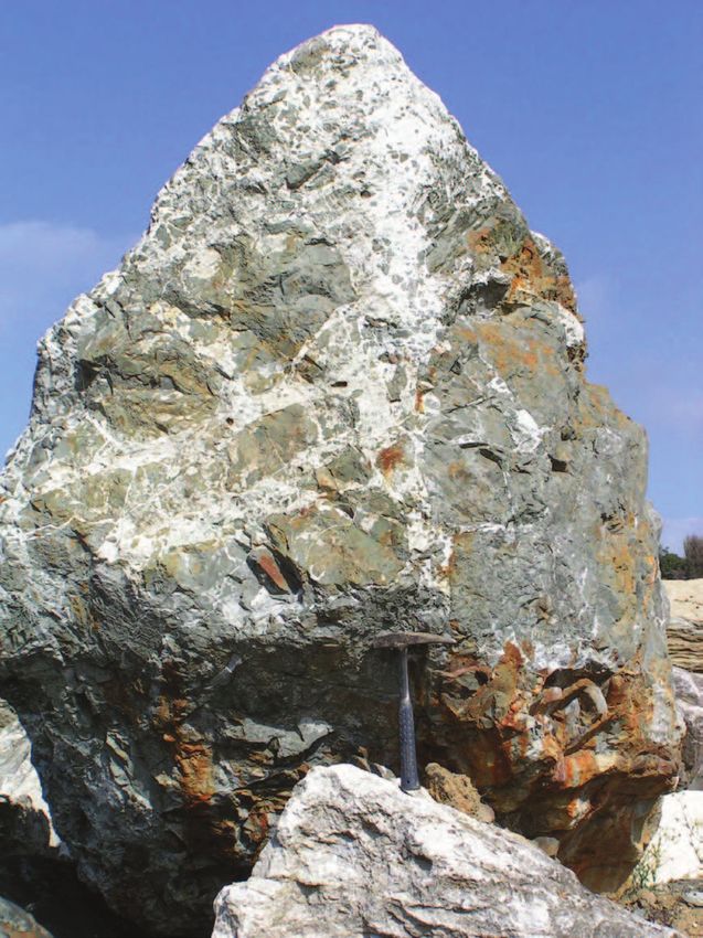
sheared serpentinite, about 700 m long and up to 70 m wide, occurs along the trace of the Waipa
Fault which runs N-S through the quarry (Fig. 15). The rocks are correlated with the Dun Moun-
tain Ultramafics Group that includes the early Permian ultramafic rocks of Nelson and Southland.
A distinctive linear positive magnetic anomaly known as the Junction Magnetic Anomaly (Hath-
erton 1967) traces the occurrence of these ultramafic rocks through the North Island. It passes
directly through the location of the Wairere Serpentinite body and thereafter closely follows the
Waipa Fault, suggesting that the fault represents a terrane suture and the serpentinite mass an
outcrop of the otherwise concealed ultramafic rocks of the Dun Mountain-Maitai terrane. The
Wairere Serpentinite itself consists of dark blue and green lenses of massive serpentinite sepa-
rated by pale to dark blue and green sheared serpentinite, all derived from a harzburgite parent
(O’Brien & Rodgers 1973, 1974; Edbrooke 2005). Xenoliths of metasomatised gabbro are com-
mon, ranging from a few cm to many metres in size, and rodingite is often developed about the
margin of the xenoliths.
The serpentinite is in fault contact with Murihiku terrane rocks and overlying Otorohanga Lime-
stone on the west side of the quarry, and with Mahoenui Group mudstone (and possibly lime-
stone) and overlying Mokau Group muddy fine sandstones and carbonaceous beds to the east.
3 . 18Awakino Field Guide Stops 5, 6 & 7
Emplacement of the serpentinite was likely a diapiric process in response to a compressive stress
system, possibly close to the time of deposition of the Otorohanga Limestone in the earliest
Miocene (Lw), or soon thereafter. Ongoing movement in the Miocene is suggested by local brec-
ciation of the contact Mokau Group sediments. The limestone suffered folding (locally to the ver-
tical) and formation of pinch-and-swell structures, local brecciation and recrystallisation, slick-
ensiding and jointing. Twinned aragonite crystals are common both at contacts and on shear
planes within the serpentinite.
Return to Piopio via the same route and turn south again onto highway 3.
Stop 5 - Murihiku terrane “greywacke” and Piopio High, Piopio (R17/855003)
Just south of Piopio stop on roadside opposite the Piopio Quarry to view the stratigraphic suc-
cession from bottom to top: west-dipping, well bedded late Triassic (Warepan, Bw) “greywacke”
sandstone with occasional interbeds of granite-bearing conglomerate (part of Murihiku Super-
group); thin earliest Miocene (Lw) Otorohanga Limestone (column C-154 and images in Fig. 16);
and early Miocene (Po) Mahoenui Group blue-grey mudstone (Taumatamaire Formation). Dis-
cuss the evolution of this section, including the Kawhia Regional Syncline, the significance of the
unconformities between the three units, and the importance of the Piopio High (or Theshold) on
Oligocene sedimentation.
Continue south on highway 3 passing occasional roadside outcrops in Murihiku basement rocks
of mainly deeply weathered, well bedded Jurassic siltstones and sandstones, and a gradually
thickening succession of Te Kuiti Group units involving Aotea Formation (lower) and Orahiri
Limestone (upper) that form impressive bluffs on either side of the Mangaotaki River.
Stop 6 - Aotea Formation - Orahiri Limestone, Mangaotaki Bridge (R17/761957)
Park at off-road bay on roadside opposite the sharp contact between Aotea Formation muddy
sandstones and Orahiri Limestone, about half way up the road incline after crossing Mangaotaki
Bridge. The Te Kuiti Group here involves basal Waimai Limestone Member on Mesozoic base-
ment overlain by a series of interbedded calcareous muddy fine sandstone and mudstone of
Kihi Sandstone Member (both in Aotea Formation, possibly upper Lwh or Ld age), which in turn
is separated by a sharp unconformity from overlying Orahiri Limestone (Ld age) which is con-
spicuously pebbly, glauconitic, phosphatic and macrofossil-rich at its base. Large fossil oysters,
diagnostic of the Orahiri Limestone (Nelson et al. 1983), occur in beds up to a few m thick at the
top of the cliffs. A stratigraphic column (C-166) and images are shown in Fig. 17. Discuss the
nature and significance of the unconformity, and the rapid variations in thickness and character
of the Te Kuiti Group in this area.
Stop 7 - Taumatamaire Formation of Mahoenui Group, Mangaotaki (R17/755946)
Near south of Stop 6, park on roadside partway up hill incline to view a road cut in moderately
calcareous mudstone of the Taumatamaire Formation. Of early Miocene (mainly Po) age, these
mudstones form a prominent thick unit in the landscape through to Mahoenui and beyond. Fo-
3 . 19Stops 8 & 9 Awakino Field Guide raminifera indicate deposition at slope depths (Topping 1978). Although often massive (biotur- bated), some outcrops exhibit faint bedding as a result of rhythmic variations in the content of terrigenous silt, suggestive of “mud turbidites”. Carbonate concretions, sometimes quite large (up to 1 m), are developed locally in the plane of bedding. A high content of clays (about 45%) in the mudstone, completely dominated by swelling smectite (Nelson & Hume 1977), poses an on-going problem in road construction for civil engineers as a consequence of cyclical wetting and drying and swelling and shrinking of the mudrocks, leading to eventual slope failure. The next couple of km of road beyond this stop has undergone major reconstruction in recent years. Stop 8 - Mahoenui depocentre overview, Mahoenui (R17/729924) Pull off highway 3 and park at Totoro Rd junction to view the landscape and geology of the entire Mahoenui depocentre. To the west Murhiku Supergroup basement forms the Herangi Range (High) on the skyline. In front of this, dipping towards us and onlapping the basement rocks, is the Oligocene Orahiri Limestone (plus thin Otorohanga Limestone) with Aotea Formation (sandstone) and Glen Massey Formation (mudstone) out of sight at the foot of the scarp slopes. The central part of the depocentre is filled with early Miocene mudstones of the Taumatamaire Formation. To the S and SE, the Papakauri Plateau forming the skyline is constructed on early Miocene Mokau Group sandstones (Bexley Sandstone). More distant views to the east show the heavily bush-clad country typical of the inland King Country region, underlain by variably erod- ed late-early to late Miocene formations that were formerly continuous with the Taranaki Basin succession. Continue south on highway 3 passing through the settlement of Mahoenui, beyond which good roadside exposures of Taumatamaire Formation mudstone with concretions (Mahoenui Group) are seen, and later a prominent dip slope developed on Black Creek Limestone within the Tau- matamaire Formation (see Fig. 19, Stop 9). Stop 9 - Oligocene-early Miocene geology, Awakino Tunnel (R17/618853) Pull over into roadside park area near north of Awakino Tunnel. The stop looks across to the (now) pine covered dip slope upon the top of the Orahiri Limestone (Ld; locally also a veneer of Otorohanga Limestone, Lw) which dips about 25-30oE towards us (Fig. 18). The Awakino Tunnel just beyond this stop is cut through the Orahiri Limestone. Above the dip slope are Taumata- maire Formation mudstones of the Mahoenui Group (Po) which in this area only include several mainly thin (
You can also read