DESCANSO BAY, GABRIOLA ISLAND - Terminal Development Plan Approved March 2019
←
→
Page content transcription
If your browser does not render page correctly, please read the page content below
DESCANSO BAY, GABRIOLA ISLAND
Terminal Development Plan
Approved March 2019
PUBLISHING INFORMATION

Title: Gabriola Terminal Development Plan (TDP)
Author: Terminal Development
Status: Approved March 2019

This version includes the following amendments:
Amendment:						Date:

ACKNOWLEDGEMENTS:

The TDP has been prepared by BC Ferries Inc. BC Ferries would like to thank BC Ferry employees, the Ferry
Advisory Committee (FAC) and the Community at large for their input during the preparation of this TDP.
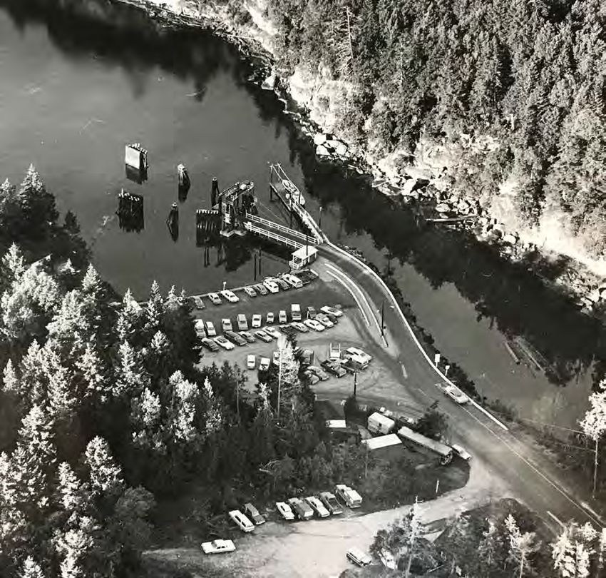
TABLE OF CONTENTS

1   Introduction
    1.1   What is a Terminal Development Plan (TDP)?
                                                                  4
                                                                   4   4    Functional Requirements
                                                                            4.1 Gabriola TDP Functional Requirements
                                                                                                                                      26
                                                                                                                                      27
    1.2 Purpose of the Gabriola Terminal Development Plan          5

                                                                       5
    1.3 Interpretation of the TDP                                  5
    1.4 Structure of the TDP                                      6         Plan Concepts                                             37
    1.5 Plan Area                                                 6         5.1 Concept Overview                                      37

    1.6 How the TDP Relates to Other BC Ferries Strategic Plans   8         5.2 Illustrative Waiting Room Washroom Building Design    41
                                                                            5.3 Utility Requirements                                  47

2   Context
    2.1 Regional Context
                                                                  12
                                                                  12
                                                                       6    Implementation
                                                                            6.1 Investment and Implementation
                                                                                                                                      48
                                                                                                                                      48
    2.2 Site Context                                              14
    2.3 Policy Context                                            14        6.2 Recommendations for Further Studies/Detailed Design   48

3
                                                                       Appendix 1–Comparison Table of Gabriola TDP with 2018 TNMP     1.1
    Key Issues & Opportunities                                    17
                                                                       Appendix 2–Glossary of Terms                                   2.1
    3.1 Summary of Existing Terminal Conditions                   18
    3.2 Route Profile                                             20
    3.3 Key Issues and Opportunities                              21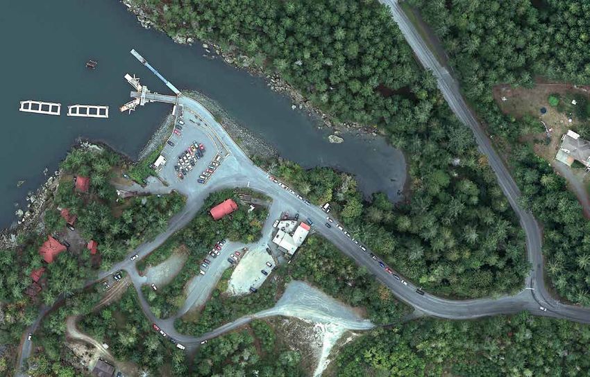
List of Figures                                                                     Figure 15: Gabriola Terminal Berth                                                   28

                                                                                    Figure 16: Queuing Traffic along Taylor Bay Road                                     29
Figure 1: Southern Gulf Islands Terminal and Route Map                         iv
                                                                                    Figure 17: Gabriola Passenger Waiting and Washroom Building are in need of
Figure 2: Terminal and Route Map                                                1
                                                                                                replacement with a new Waiting room/Washroom Building                    31
Figure 3: Gabriola Terminal Aerial Photograph                                   2
                                                                                    Figure 18: Opportunity to improve pick-up drop‑off area for Gabriola Community
Figure 4: Gabriola Terminal Development Plan (TDP) Timeline                     3
                                                                                                (Gertie) bus                                                             31
Figure 5: Gabriola Location Map                                                 5
                                                                                    Figure 19: Barrier free design and removal of curbs and barriers to improve safety
Figure 6: Gabriola TDP Study Area                                               7               should be incorporated into the design                                   31
Figure 7: Relationship between Strategic Plan, Terminal Network Master Plan         Figure 20: Pick-up and drop‑off area is congested and constrained                    31
           and Terminal Development Plans                                      9
                                                                                    Figure 21: Customer Information Reader Board Sign Example                            33
Figure 8: Photo of the Quinsam and Rendering of the Island Class Replacement   11
                                                                                    Figure 22: Crew parking spaces are required at the terminal                          34
Figure 9: Gabriola in 1977 and 2016                                            13
                                                                                    Figure 23: Install a covered bike stand at the terminal given the high numbers
Figure 10: Gabriola Existing Site Plan                                         18               of cycle commuters using the terminal                                    35
Figure 11: Photos of the Existing Terminal                                     19   Figure 24: Implement sustainable storm water bioswales/rainwater gardens to
Figure 12: Key Issues identified by the Working Group                          22               deal with storm water run-off where possible                             36

Figure 13: Traffic Safety Review Key Issues                                    25   Figure 25: Traffic Safety Review Short Term Recommendations                          38

Figure 14: Improving traffic safety at the terminal is a key issue.            27   Figure 26: Illustrative Concept Plan for Gabriola Terminal                           39

                                                                                    Figure 27: Illustrative Concept Plans for Pick-Up/Drop-Off Area                      40

                                                                                    Figure 28: Main Floor Plan                                                           43

                                                                                    Figure 29: Waiting Room/Washroom Building – Sections                                 44

                                                                                    Figure 30: Waiting Room/Washroom Building – Elevations                               45

                                                                                    Figure 31: Illustrative Concept Design – Waiting Room/Washroom Building              46

                                                                                    List of Tables

                                                                                    Table 1:   Vessel Replacement Specifications for Island Class Vessel                 10

                                                                                    Table 2: Terminal General Information                                                18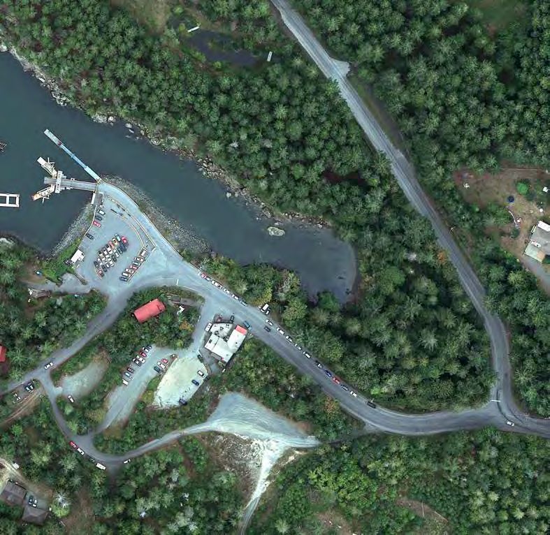
Gabriola TDP | 2018

    BC Ferries Terminal Network
    Alert Bay Cormorant Island                         Port McNeill Port McNeill
    Bear Cove Port Hardy                               Preedy Harbour Thetis Island
    Bella Coola Bella Coola                            Prince Rupert Prince Rupert
    Blubber Bay Texada Island                          Quathiaski Cove Quadra Island
    Brentwood Bay Saanich Peninsula                    Saltery Bay Sunshine Coast
    Buckley Bay Buckley Bay                            Shearwater Denny Island
    Campbell River Campbell River                      Shingle Spit Hornby Island
    Chemainus Chemainus                                Snug Cove Bowen Island
    Crofton Crofton                                    Sointula Malcolm Island
    Denman West Denman Island                          Sturdies Bay Galiano Island
    Departure Bay Nanaimo                              Swartz Bay North Saanich
    Descanso Bay Gabriola Island                       Tsawwassen Lower Mainland
    Duke Point Nanaimo                                 Vesuvius Bay Salt Spring Island
    Earls Cove Sechelt                                 Village Bay Mayne Island
    Fulford Harbour Salt Spring Island                 Whaletown Cortes Island
    Alliford Bay (Gaats’iiGundaay) Haida Gwaii         Westview Powell River
    Gravelly Bay Denman Island East
                                                                                        Langdale
    Skidegate Landing (GuuhlGa Llnagaay) Haida Gwaii           Nanaimo                        Bowen          Horseshoe Bay
                                                                             Gabriola         Island
    Heriot Bay Quadra Island                                                  Island

    Horseshoe Bay West Vancouver
                                                           Chemainus         Thetis Island
    Klemtu Klemtu                                                            Penelakut Island

    Little River Comox                                          Crofton
                                                                          Vesuvius
                                                                                 Long Harbour
                                                                                       Galiano Island                 Tsawwassen
    Langdale Sunshine Coast                                             Salt Spring
                                                                          Island     Sturdies Bay
                                                               Fulford Harbour
    Long Harbour Salt Spring Island
                                                                                                       Village Bay
    Lyall Harbour Saturna Island                                                     Otter Bay
                                                                                                       Mayne Island

    McLoughlin Bay Bella Bella                                  Swartz Bay                   Pender
                                                                                             Islands
                                                                                                            Saturna Island
    Mill Bay Mill Bay                                     VANCOUVER
                                                            ISLAND
    Nanaimo Harbour Nanaimo
    Ocean Falls Ocean Falls                                               Victoria

    Otter Bay Pender Island
    Penelakut Penelakut Island                         Figure 1: Southern Gulf Islands Terminal and Route Map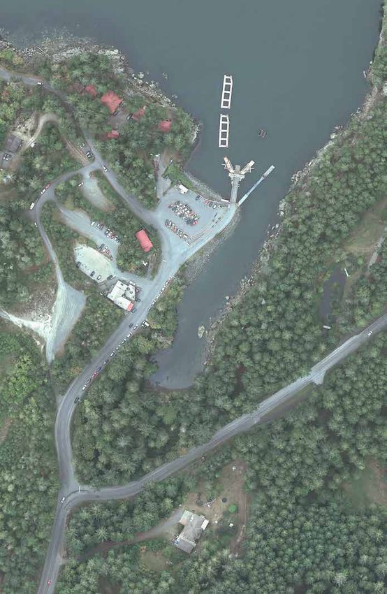
Prince Rupert

                                           HAIDA
                                           GWAII
                                   Skidegate Landing
                                   (GuuhlGa Llnagaay)

                                                        Alliford Bay
                                                        (Gaats’iiGundaay)

                                                                                               Klemtu

                                                                                                      Ocean Falls

                                                                                  McLoughlin Bay              Bella Coola
                                                                                                    Shearwater

                                                                                                        Bear Cove
                                                                                                                  Sointula

                                                                                                   Port McNeill     Alert Bay

                                                                                                           VANCOUVER                                  Whaletown
                                                                                                             ISLAND                 Quathiaski
                                                                                                                                    Cove       Heriot Bay Westview
                                                                                                                                Campbell River                   Saltery Bay
                                                                                                                                                          Blubber      Earls Cove
                                                                                                                                        Little River      Bay
                                                                                                                                                                           Langdale
                                                                                                                                     Denman Island    Shingle Spit
                                                                                                                                       Buckley Bay Gravelly Bay           Snug
                                                                                                                                                                               Horseshoe Bay
                                                                                                                                                                          Cove
                                                                                                                                         Descanso Bay                          Vancouver
                                                                                                                                                   Departure Bay
                                                                                                                                                 Nanaimo Harbour     Duke Point     Tsawwassen

                                                                                                                                                                             Swartz Bay
                Figure 3: T
Figure 2: Terminal and Route Map
                                                                                                                                                                             Victoria

                                                                                                                                                                                                 1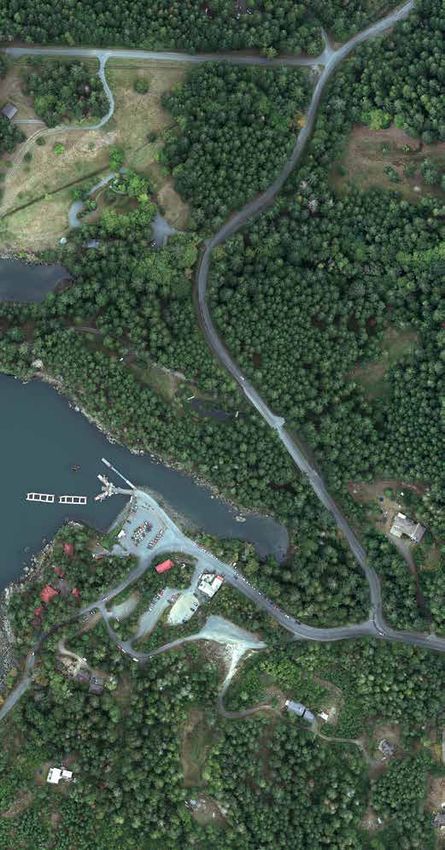
Island Conference Centre and May 16, 2018 at
event, interacting via email,
the Gabriola Island Arts Council Hall. These
Gabriola TDP | 2018 or completing surveys
events were designed to educate and start
(online and at event)
a conversation with the residents of both
3
communities.
The May engagement event focused on:
Top
Comments*
HOW the community gets to and from the
terminals
Improve
WHY the terminal is important to the FERRY TRAFFIC
community (points of entry and exit,
impacts of traffic back-ups
WHAT challenges does the community face on roadways)
today when using BC Ferries
WHAT opportunities exist to improve the
terminal Improve
SAFETY
(size of holding compound,
traffic overflow, separate
pick-up/drop-off area)
What’s Next
The community feedback collected will be
used to inform the Nanaimo Harbour and Improve
Gabriola Island Terminal Development Plans. AMENITIES
(waiting room,
customer amenities)
YOUR INPUT IS IMPORTANT TO US AND WILL HELP SHAPE OUR FUTURE PL
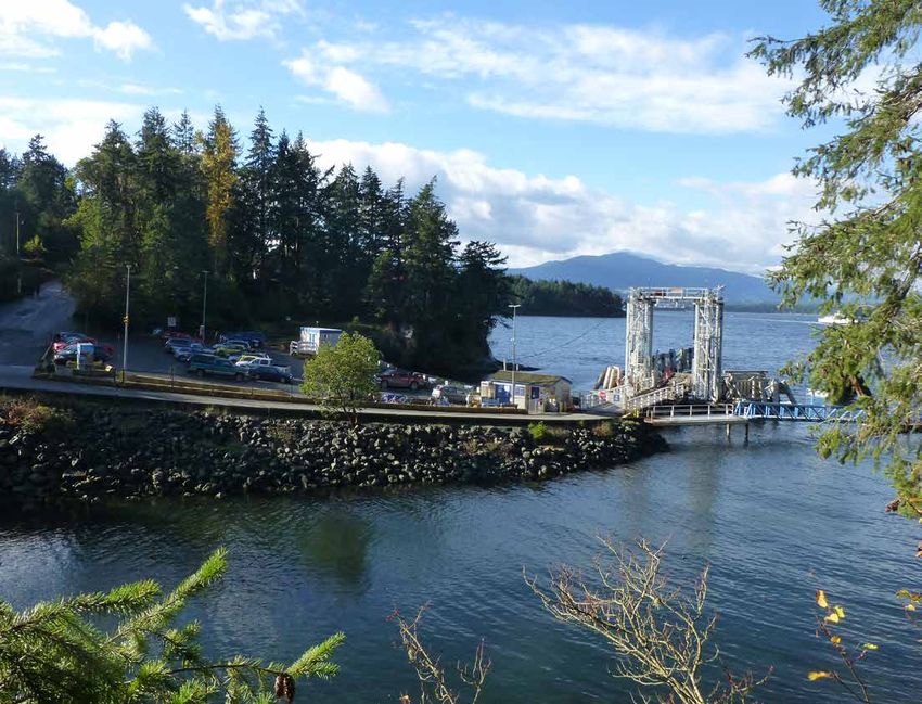
Figure 3: Gabriola Terminal Aerial Photograph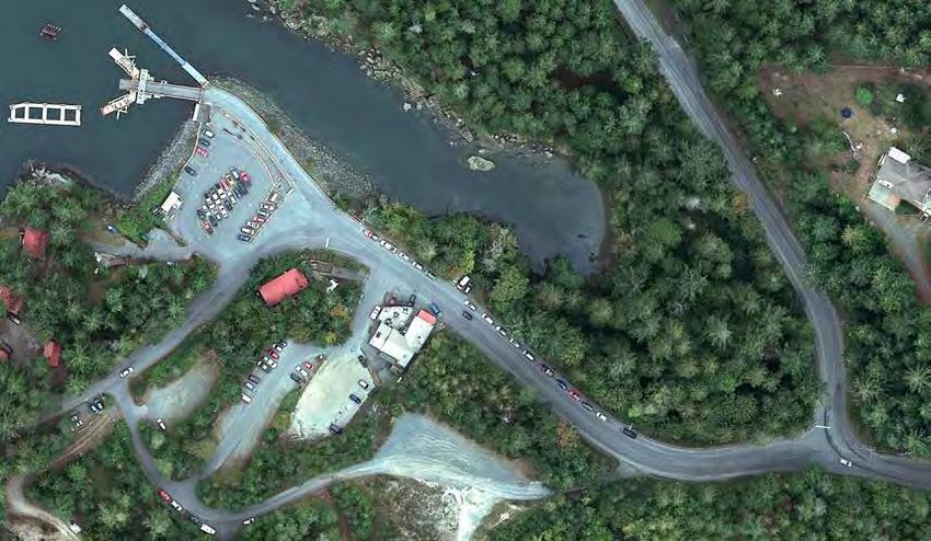
JAN                      JAN–FEB                          FEB–MAY                        JUN–SEP                                 SEP–OCT                FEB
        2018                       2018                             2018                           2018                                    2018                 2019

      PHASE 1                     PHASE 2                         PHASE 3                        PHASE 4                                 PHASE 5               PHASE 6
      Pre-Planning                Baseline Report &               Key Issues &                   Draft Options                           Draft TDP             Final TDP
                                  Gap Analysis                    Opportunities                                                                                Approved by
                                                                                                                                                               BC Ferries

                                                                                                     Analysis of feedback
                                                                                                     and development of
                                                                                                     preferred options

               Review of relevant                 Internal Engagement                     External Engagement                     Revised Draft Concept                Final TDP posted to
               background information             Feb–May 2018                                                                    posted to BC Ferries                 BC Ferries website
                                                                                          2 Open Houses
               and studies                                                                                                        website and presented at             for pubic review
                                                  Staff Information Session               Nanaimo, Gabriola Island–May 2018       an Open House
                                                  External Engagement                     Online Engagement
                                                  Meetings with Key Stakeholders                                              External Engagement
                                                  Meeting with Ferry Advisory Committee                                       Meetings with Key Stakeholders

Figure 4: Gabriola Terminal Development Plan (TDP) Timeline

                                                                                                                                                                                         3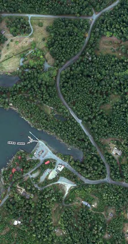
Gabriola TDP | 2018

      1 INTRODUCTION
1.1 What is a Terminal                                      TDPs shall specify:                                     Over the next 25 years the Terminal Network will
                                                                                                                    be optimized for efficient and effective operation.
    Development Plan (TDP)?                                  •   Terminal classification
                                                                                                                    BC Ferries will study routes and their interactions
A Terminal Development Plan (TDP) is a concept               •   Berth classification(s)                            to determine ways to reduce operating and capital
plan that provides the framework for the phased              •   Description of existing facility                   costs and increase system reliability. Terminals
implementation of strategies and actions over the next       •   Existing traffic demand and growth projections     will be examined for improvement to construction
25 years that will enable BC Ferries to develop terminals                                                           and operating efficiencies. Greater use of standard
                                                             •   Terminal lands and property, including
                                                                                                                    designs and components will aid these efficiencies
in a cost effective, organized and efficient way.
                                                                 stakeholder and community consultation and
                                                                                                                    over time.
                                                                 archaeological assessments
                                                             •   Existing terminal infrastructure
                                                             •   Existing safety, security and operational issues
                                                             •   Existing and future vessel deployment
                                                             •   Functional requirements, as drawn from
                                                                 Terminal Design Requirements contained in the
                                                                 TNMP and established in consultation with local
                                                                 area teams
                                                             •   Future terminal development plans, including
                                                                 the scope, schedule and budget of all
                                                                 improvements to be carried out over the next
                                                                 25 years
DESCANSO
BAY
Departure
Bay
GABRIOLA
ISLAND
19
1
1.2 Purpose of the Gabriola
Terminal Development Plan 19
NANAIMO
The purpose of the Gabriola TDP is to set out a
long‑term vision for the future of this important
terminal which acts as the main gateway and route
connection between Gabriola Island and Nanaimo
Harbour terminal on Vancouver Island.
The TDP is future oriented and depicts how the
Gabriola terminal is to be developed over an extended
period of time through a series of initiatives.
1.3 Interpretation of the TDP
Unless otherwise specified within the TDP, the
boundaries and locations of any symbols or areas
shown on a Figure are approximate only and shall be
Nanaimo
interpreted as such. They are not intended to define Airport
exact locations except where they coincide with clearly
recognizable physical features or fixed boundaries,
such as property lines and utility rights-of-way.
Figure 5: Gabriola Location Map
5Gabriola TDP | 2018
1.4 Structure of the TDP
The scope of the Gabriola TDP covers planning, The TDP represents a cooperative effort which
conceptual design and development of an involves a high degree of interaction with and input
implementation schedule and budget estimates for from a wide range of participants.
upgrading the terminal with the requirement to:
A comprehensive “baseline review” report has been
• Review existing terminal operations, completed as a separate report which details the
infrastructure conditions and customer service existing situation in the TDP area as it currently
issues and interface. stands and identifies issues affecting the production
• Establish future functional requirements at the of the TDP.
terminal that are consistent with future plans
for vessel procurement and deployment and 1.5 Plan Area
overarching strategic master plans.
The study area for the Terminal Development Plan
• Review foot passenger and vehicle traffic
encompasses the marine infrastructure, the landside
demand projections including demand
infrastructure and the approach to the terminal.
management policies and opportunities.
• Develop and find solutions to accommodate the
functional requirements including evaluation of
alternatives.
• Recommend a preferred plan for the terminal
that is in accordance with the overarching
Terminal Network Master Plan.
• Prepare conceptual designs for the
recommended terminal plan including the
general arrangement of the site.
• Develop an estimate of the capital cost, project
phases, and schedule of work.
• Engage with various stakeholders during the
course of the TDP.Figure 6: Gabriola TDP Study Area
7Gabriola TDP | 2018
1.6 How the TDP Relates to Other BC Ferries Strategic Plans The Strategic Plan outlines five strategic drivers
that will inform strategic decision-making over the
To align with BC Ferries future, long‑term vision and objectives the TDP is guided by three overarching planning horizon. They are the critical success factors
documents: the Strategic Plan, Terminal Network Master Plan and Fleet Master Plan. that must be in place to achieve our strategic goals
that BC Ferries will pursue to achieve this vision:
1.6.1 STRATEGIC PLAN
The 2018 Strategic Plan was prepared to guide the long-term direction of BC Ferries and achieve the Operational Excellence:
organization’s vision. The Strategic Plan’s vision is as follows: We strive for a superior customer
experience through safe, efficient,
reliable and effective service delivery.
VISION MISSION
Financial Sustainability:
Trusted, valued. We connect communities and customers to the
We make prudent choices for the
people and places important in their lives.
long-term growth and sustainability of
our organization, which enables fare
affordability, value for customers and
OUR VALUES effective asset stewardship.
Safe Employee Engagement:
Safety is our highest value. We foster growth, development and
Caring commitment in our people.
We operate from a position of kindness and empathy for those Environmental and Social
who travel and work with us. Governance:
Honest We leverage our resources, services
We conduct business with integrity, honesty and accountability. and relationships in recognition of
our responsibility to our environment,
Collaborative customers, employees, stakeholders and
We collaborate with others to enhance the customer experience. communities.
Respectful Innovation and Continuous
Respect is paramount in our interactions with others. Improvement:
Sustainable We nurture continuous improvement
Our environmental, social and economic impact are central to and innovation across our organization.
business decisions.
All actions and strategies proposed in this TDP will
align with these five strategic drivers where possible.1.6.2 TERMINAL NETWORK MASTER PLAN The Fleet Master Plan identifies: The Fleet Master Plan (2018) indicates a change to
vessel deployment proposed for Route 19. With the
The Terminal Network Master Plan (TNMP) is a • When a vessel will retire
retirements of the Bowen Class vessels it has been
forward-looking planning and policy document
• When a ship will be replaced proposed to introduce two Island Class vessels in
with a 25 year outlook. The TNMP aligns with
the Corporate Strategic Plan and forecasts all the
• The class, model and characteristics of the March 2021 to better meet demand over the day
replacement vessel through an increase in frequency and capacity. The
strategic and major tactical actions governing the
development of the BC Ferries terminal network. A • The 25 year deployment of any vessel Quinsam will redeploy to Route 6 until its scheduled
retirement in April 2029.
network refers to how routes interact singularly, in
conjunction, or as a system of routes.
Each terminal shall have a Terminal Development
Plan (TDP) which aligns with the TNMP. Terminal Strategic Plan
Engineering is responsible for the TDP and the
TDP schedule. The TDP is guided by the TNMP by
aligning with its terminal classifications and design
requirements.
Gabriola terminal is classified as a Minor / Intermediate
Learnings Terminal Network Master Plan
(MIM) – Unstaffed terminal. As a result, the design
Fleet Master Plan
requirements of the Gabriola terminal shall adhere
IT Master Plan
to the design requirements of an MIM – Unstaffed
terminal and is further elaborated upon in this TDP.
1.6.3 FLEET MASTER PLAN
The Fleet Master Plan translates the broad direction Terminal Development Plans
Project Planning &
from the Strategic Plan in to specific strategies, Implementation Vessel Procurement & Sustainment
policies and tactics that apply to the BC Ferries fleet. IT Development Plans
BC Ferries fleet will transition from a fleet of many
unique vessels to a fleet of vessels that have high
physical and operational commonality. The number of Project
unique vessels in the fleet will be minimized. Common Business Case Capital Plan
operational and maintenance procedures will be used
as far as practicable. New vessel designs will emphasize
safety, environmental stewardship, efficiency,
standardization, class builds and customer experience. Figure 7: Relationship between Strategic Plan, Terminal Network Master Plan and Terminal Development Plans
9Gabriola TDP | 2018
Table 1: Vessel Replacement Specifications for Island Class Vessel
Vessel Replacement Specifications
Vessel Description
Class Island Class
Model 47
Crew Estimated Crew Size 6/7/8
Live Aboard No
Performance Service Speed (kts) 15
Capacity Automobile Equivalent 47
Lane Meters 270
Commercial Vehicle Height (maximum) 100%
Passenger & Crew 150/300/450
Characteristics Voyage Classification NC2
Double or Single Ended Double-ended
Berth Compatibility Single Ramp Double Lane
Car Deck Configuration Open
Passenger Boarding Traffic segregation
Berth Interface Type (BIT) MIM
Flexibility of Use on Alternative Routes Sheltered Waters or Near Coastal Class 2 routes
with BC Ferries’ standardized minor/ intermediate
berth configuration
Dangerous goods Yes
area integrated
Passenger Indoor Seating 100
Amenities & Outdoor Seating 60
Services Interior Design Standards Fleet Interior Design Standard
Passenger lounge Location Main Deck
Passenger Services Accessible Car Deck
Lounge, Work/Study stations, Vending, Accessible
washrooms
Vessel server rooms Should conform to standard BC Ferries IT
operating requirements as outlined in FMPFigure 8: Photo of the Quinsam above and Rendering
of the Island Class Replacement below
11Gabriola TDP | 2018
2 CONTEXT
2.1 Regional Context
Gabriola Island, the most northerly of the Southern By 1874, seventeen settlers, many of whom had Today the island has a full-time population of more
Gulf Islands, lies in the Strait of Georgia between married First Nations women, were working the than 4000. Farming is still an important occupation,
mainland BC to the east and Vancouver Island to the land and supplying food to Nanaimo. Later settlers but Gabriola is also home to many visual and
west. It is an Islands Trust island and is also part of quarried Gabriola’s abundant supplies of sandstone performing artists, and home-based business are a
the Regional District of Nanaimo. for use as millstones in pulp mills and for construction vital part of the economy. Unlike some other Gulf
in cities from Vancouver to San Francisco. From the Islands, many Gabriolans use the ferry to commute
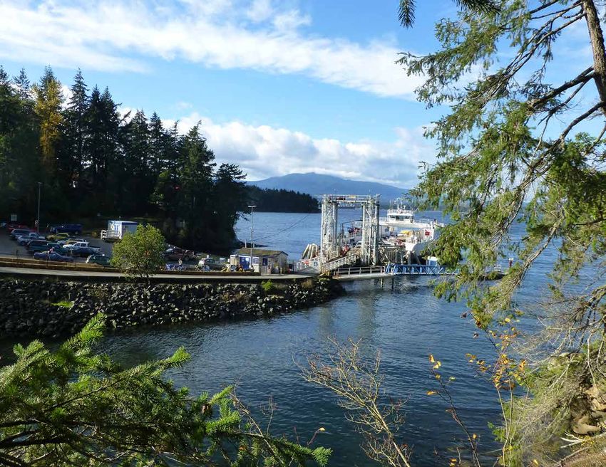
The Gabriola terminal is located at Descanso Bay on
1890s to 1952, the Gabriola Brickyard was mining to work and school on Vancouver Island. Gabriola
Gabriola Island, approximately 5 kilometers east of
shale on Gabriola and producing up to 80,000 high is a popular destination for summer residents and
Nanaimo on Vancouver Island. The terminal serves
quality bricks a day, while the sheltered waters of tourists, so the ferry is much more heavily used in
Route 19, which connects Nanaimo Harbour on
Silva Bay were home to a fishing fleet, a lumber mill summer than in winter.
Vancouver Island with Gabriola Island, and is located on
and a thriving shipyard that was the Island’s largest
the traditional territory of the Snuneymux First Nation.
employer in the 1960s. In 1950, Gabriola had fewer
In 1791, Spanish explorers Narváez, Galiano and than 400 full-time residents.
Valdés landed on Gabriola. They were followed a
year later by British explorer George Vancouver. But
it was the discovery of coal on nearby Vancouver
Island that sparked European settlement on Gabriola
in the 1850s and 60s.Figure 9: Gabriola in 1977
and 2016
13Gabriola TDP | 2018
2.2 Site Context 2.3 Policy Context There are also numerous OCP policies and advocacy
policies that are relevant to the development of the
The Gabriola terminal is located at the north western 2.3.1 GABRIOLA ISLAND OFFICIAL Gabriola terminal as follows:
end of Gabriola Island at the end of North Road. Up COMMUNITY PLAN
the hill from the terminal is the main village centre Section 6 – Environmental, Marine, and
The Gabriola Island (Islands Trust) Official
of Gabriola with several commercial businesses. Heritage Resources
Community Plan (OCP) was adopted on November
Outside of the village, the area around the terminal is
generally rural with residential lots.
26, 1998. OCPs are the overarching planning 6.1 – Environmentally Sensitive Area Policies
documents that set out the community vision and
There is no holding compound at the terminal, b) With respect to an area identified as being
values that guide decision making about the future
instead vehicles queue along North Road and then environmentally sensitive, the registration of
direction of each municipality. They also provide
along Taylor Bay Road. a natural state or environmental covenant
clarity for residents, businesses and institutions on
and/or the use of a development permit
the primary goals objectives and supporting policies
At the terminal itself there are no pedestrian shall be required as a condition of rezoning
that help the municipality to meet its goals.
facilities, except for a barrier-separated walkway so as to ensure the long‑term protection of
and waiting area between the parking lot and the The OCP designates the terminal as follows: environmental features.
terminal ramp. Outside of the terminal area there are
PID 025-798-103: Split-designated Resource (R) c) Voluntary covenants or easements to protect
generally no dedicated pedestrian or cycling facilities
and Small Rural Residential (SRR) natural features and donation or sale of
(or even shoulders that could be used), and thus
these road users share the road with motorists. sensitive areas to a conservation agency shall
PID 025-798-090: Split-designated Resource (R)
be encouraged.
(applicable to the upland portion of the parcel)
There is no formal drop-off or pick-up location at
and Marine (M), applicable to the marine portion e) To protect against hazardous conditions and
this terminal. This activity can occur at the terminal
of the parcel. to protect environmentally sensitive areas a
during lower traffic queue periods, but otherwise
occurs in the parking lot or in the vicinity of the setback shall apply from the high water mark
terminal. of the sea. In the case where a bluff or large
land ridge is the prominent upland feature
The terminal is served by a community transit bus adjacent the sea, a setback from the upper
(Gertie) with a stop at the terminal on Easthom edge of the bluff or ridge shall be applicable.
Road. Once the bus has picked up passengers the bus
will then reverse into the exit lanes and go back up f) The sandstone and conglomerate banks
North Road. along Gabriola’s shoreline shall be protected
against the accelerated effects of erosion
resulting from human activity by requiring
the setback of buildings or structures and
control of storm water runoff.g) Trees bearing the nests of great blue heron, l) Any future applications to establish a new Water Transportation Advocacy Policies
bald eagle, osprey and other raptors shall marina or expand an existing marina shall
g) The BC Ferry Corporation shall be requested
not be cut in accordance with provincial be conditional on it being demonstrated that
to ensure that changes to the ferry service
legislation. The zoning bylaw shall set the use can be carried out while minimizing
involves consultation with the local
standards and regulate the provision of conflict with other recreational uses and
community.
screening for preserving and protecting trees no damage will occur to nearby areas of
bearing such nests. Such condition shall be ecological significance. h) The following issues shall be discussed with
applicable with respect to the rezoning of the BC Ferry Corporation:
p) Harvest refugia areas shall be encouraged in
any site containing such a feature.
the Gabriola Planning Area i. the scheduling of a late evening weekend
i) So as to ensure the Island’s environmental ferry;
resource sites are protected, owners (and Section 7 – Transportation and Servicing
ii. the provision of parking at the Gabriola
potential developers) of property located 7.1 – Land Transportation Policies
within an environmental sensitive area shall ferry terminal;
be encouraged to work with recognized k) The creation of an off-road bicycle and iii. safe pedestrian routes to the Gabriola
conservancy organizations early on in the pedestrian trail along Gabriola’s busiest ferry terminal;
development process to ensure steps are taken traffic corridor from the ferry hill to Tin
to protect the environmentally sensitive site Can Alley should be considered when land iv. the scheduling of the ferry with the
use decisions, rezonings, subdivisions, road Nanaimo public transit service;
6.2 – Marine Resources Policies resurfacing or other development occurs
v. the establishment of incentives for foot-
along this route
h) In foreshore locations where commercial passengers.
and industrial uses are permitted adequate 7.2 – Water Transportation Policies i) The BC Ferry Corporation shall be requested to:
provision shall be made for public access to
the foreshore. c) A major ferry terminal on Gabriola to i. consult with the Trust Committee and
provide service to Vancouver Island and/ public, prior to giving consideration to any
i) No building shall be permitted beyond the or a Lower Mainland destination shall be major alteration to the ferry service to
high water mark of the sea. strongly opposed as it is inconsistent with the Gabriola;
k) Natural coastal processes shall be left objectives and policies of this plan.
ii. continue to provide an adequate level of
undisturbed to the maximum extent possible e) Maintenance of the present ferry terminal service for the needs of residents;
and there shall be no deposition of material sites on the Gabriola and the Nanaimo sides
below the natural boundary of the sea unless is strongly supported. iii. ensure all vessels and associated upland
a permit is issued by Ministry of Environment facilities meet the standards of the
and DFO authorizing a breakwater or a Ministries of Health and Environment,
seawall to be constructed. Lands and Parks.
15Gabriola TDP | 2018
2.3.2 DEVELOPMENT PERMIT AREAS 2.3.3 ZONING BYLAW
S.488 of the Local Government Act authorizes The Gabriola Terminal is split zoned. The water lot is The following are the permitted uses of the LRR
municipalities to designate Development Permit zoned Water Commercial 3 – Marine Transportation zone:
Areas (DPAs) and request Development Permits prior (WC3), and the leased upland is zoned Large Rural
to the commencement of development for certain Residential (LRR). Ferry terminal is listed as a
• Single family residential
issues outlined in the section. permitted use in the WC3 zone. • Agriculture, including the sale of agricultural
products grown or raised on the lot, but
The Gabriola terminal site is not located within The following are the permitted uses of the WC3 excluding animal husbandry on lots less than
a Development Permit Area (DPA). However, the zone: 2.0 hectares (4.94 acres)
terminal is located adjacent to sensitive ecosystems
as follows:
• Ferry dock The following Zoning Bylaw general regulations also
• Public moorage and dockage
apply to the terminal as follows:
• Rockfish conservation area
• Public wharves • No buildings are permitted in the WC3 zone.
• Two raptor nests in the vicinity of the site
• Marine navigational aids
• An eelgrass patch in the vicinity of the site
• Upland areas near the terminal site are part of
the Mature Forest ecosystem3 KEY ISSUES &
OPPORTUNITIES
Summary of Existing Terminal Conditions,
Route Profile, Key Issues & Opportunities
17Gabriola TDP | 2018
COMPOSITE PLAN OF GABRIOLA
3.1 Summary of Existing Terminal
FERRY TERMINAL
Conditions
Gabriola terminal is a Minor / Intermediate Unstaffed
terminal.
Table 2: Terminal General Information
Terminal General Information
Gabriola Terminal Summary
Location Gabriola Island
Municipality Islands Trust, Regional DL 2058
District of Nanaimo
PLAN VIP75537
DL
Holding Capacity (AEQ) 0 (73 on the road) 20
93
Max Vehicle Weight (GVW) 39,500 kg with a maximum
of 5 loaded axles PL
AN
Parking Crew parking - 16 spaces EP
C7
Waiting Room Yes 91
BOOK OF REFERENCE LOT A
Washrooms Yes
PARCEL AREA
PLAN
VIP75538
Dock 1 berth MIM
DATE OF PHOTOGRAPHY: SEPT 09, 2016
Figure 10: Gabriola Existing Site Plan
British Columbia
Ferry Services Inc. DESFigure 11: Photos of the Existing Terminal
19Gabriola TDP | 2018
3.2 Route Profile
The terminal connects Descanso Bay on Gabriola
Island with Nanaimo Harbour on Vancouver Island.
The vessel that services the route is the Quinsam, a
ferry built in 1982. The Quinsam has a car capacity
of 63 AEQ, can carry a maximum of 400 passengers
Quinsam – Route Profile Summary
and crew and is equipped with four accessible car
deck lounges, vending machines and accessible Core Service Levels
washrooms.
Hours of Scheduled Service 06:55 to 11:00
The Quinsam sails between Gabriola and Nanaimo Peak Season Service Frequency 14 sailings/daily
Harbour terminals with 14 departures daily carrying 13 sailings Wed/Sun
passengers and vehicles on the 20 minute sailing.
Off Peak Service Frequency 14 sailings/daily (Mon-Sat)
13 sailings Wed/Sun/Sat)
A total annual number of 4,955 round trips are
contractually delivered. Sailings between Gabriola Round Trips per Year A total annual number of 4,955 round trips are to be contractually delivered
and Nanaimo Harbour operate year round and space
Vessel Description
on this route is on a first-come, first-served basis.
Class Minor
The Quinsam has a voyage classification of sheltered
waters and a docking cycle of 1 in 4 years and is Maximum Capacity
scheduled for retirement in 2029. During Quinsam Passenger Capacity 400 including crew
refit periods service on route 19 is provided by the Crew Size 7 or 8
Bowen Queen.
Vehicle Capacity (AEQ / tonnes) 63 AEQ
Onboard Services Accessible Car Deck Lounge, accessible washrooms
Route and Service Description
Distance 3 nautical miles
Crossing Time 20 minutes3.3 Key Issues and Opportunities FORECASTED TOTAL PASSENGER GROWTH 2017-2041
The TDP has been informed by community and BC
+4,548
Ferries staff feedback. Figure 12 illustrates the current
issues associated with the existing condition of the
passengers in
Gabriola terminal. The key issues and opportunities the next 23 years
identified are as follows:
• Lack of a holding compound and vehicles
queuing along the shoulder of North Road and 775,000
Taylor Bay Road. Along Taylor Bay road vehicles TOTAL PASSENGERS
make potentially unsafe u‑turns to join the back
of the ferry lineup. 770,452 2041
•
762,000
TOTAL PASSENGERS
Poor customer amenities including an outdated
washroom and waiting room building, resulting
in a lack of ‘sense of place’ and no community
2017 TOTAL PASSENGERS
connection or ‘sense of arrival’ to the island
• No formalized pick-up drop‑off areas resulting in
2027
a congested and haphazard area at and near the
terminal during unloading and loading periods
• Inadequate pedestrian and cyclists facilities
for those customers arriving and departing the
terminal
• No customer information on current service
• Forecasted growth. The projection would see
future volumes dip slightly from 2017’s total of
770,452 passengers to 762,000 passengers in
2027, before climbing to 775,000 passengers in
2041.
21Gabriola TDP | 2018
Marine infrastructure reaching Waiting Room/Customer Congested Terminal Ferry Traffic – Points of Entry and Exit,
end of service life and needs Amenities reaching the Parking and Pick‑up/ and Impacts of Traffic Back‑ups on
to be upgraded to allow for end of their service life Drop-off Roadways Near Terminal
new Island Class Vessel
Figure 12: Key Issues identified by the Working Group23
iola Gabriola
IslandTDP- Gabriola Terminal
Penelakut Island
Vesuvius
Crofton Long Harbo
| 2018 Salt Spring Galian
Island Sturdi
Fulford Harbour
Otter B
Swartz Bay P
Is
3.3.1 TRAFFIC SAFETY REVIEW Problem #3: U-Turning along Taylor Bay Road VANCOUVER
ISLAND
In 2017 Watt Consulting Group were appointed to Much of the traffic wanting to get into the queue Victoria
undertake a traffic safety review of the terminal is from the south part of the Island, which requires
to help inform the TDP. The review focused on the traffic to complete u-turns into the queue. Taylor Bay
loading and unloading areas of the terminal, as well Road is a windy road with a number of horizontal
as the terminal approach roads. The study excluded and vertical curves which restricts sight distance,
the dock and marine aspects of the terminal. making much of the u-turning very unsafe. This
X3 | Vertical curve with P1 | Informal pick-up point U1
is exacerbated by motorist’s urgency to get into
Problem #1: Unloading Vehicles Cross Centre limited visiblity
line
X2 | Horizontal curve with the queue, particularly in the summer during peak
on North Road
limited visiblity service demand. There is a designated u-turn area at
During the site visit, a significant number of vehicles Ivory Way, which is approximately 800 P2meters from
+ C1 | Need
were observed crossing the centre line on North the terminal. Often drivers will risk the u-turn atand
pedestrian the cycling
Road. This would be a safety issue if a vehicle was end of the queue as opposed to driving accommodation
to Ivory Way,
stopped at the stop bar which is a likely event. potentially resulting in being further back in the
queue. There are signs restricting u-turning and the
Problem #2: Pedestrian and Cyclist
police patrol this regularly based on our
X1 discussion
| Limited sight distance U1
Accommodation
with the local RCMP detachment. (35m)
There are no pedestrian and cycling facilities. It is
Problem #4: Sight Distance at Taylor Bay Road
expected that as traffic volumes increase to and from
and North Road
the Island, the level of exposure for vulnerable road
users (e.g., pedestrians and cyclists) will increase. Due to the queuing traffic on North Road, sight
While on-street parking and ferry queues take up U1Road
distance at the stop sign at Taylor Bay | Vehicles
is unloading
much of the off-road space, cyclists and pedestrians restricted. cross the centreline
are
X4travelling on the
| U-turns are road and amongst traffic
occuring X5
with
throughout this lengthunpredictable
uncontrolled and and movement.
Observations included pedestrians crossing at
butting into line
multiple points along the road. Due to the terminal’s
proximity to downtown Nanaimo, the walking and S1 | Lack of pedestrian
X5 | Vehicles u-turn signage and crosswalks
cycling demand at this terminal is significant.
here creating
C2 | Need bike
congestion and
accommodation
conflicts
Since 1983
SINCE 1983 FONT = HAND OF SEAN
CONSULTING GROUP = FRANKLIN GOTHIC DEMI COND
#501 - 740
Victoria, B
(250) 388-
Drawn: VN Consulting Group www.wattIssues Gabriola Island - Gabriola Terminal
Traffic Safety Review
Issues Gabriola Island - Gabriola Terminal
X3 | Vertical curve with P1 | Informal pick-up point U
limited visiblity
X2 | Horizontal curve with
limited visiblity
P2 + C1 | Need
pedestrian and cycling
X3 | Vertical curve with accommodation
P1 | Informal pick-up point U1
limited visiblity
X2 | Horizontal curve with
limited visiblity
X1 | Limited sight distance U
P2 + C1 | Need
(35m)
pedestrian and cycling
accommodation
X1 | Limited sight distance U1
(35m)
U1 | Vehicles unloading
cross the centreline
Legend X4 | U-turns are occuring X
throughout this length and
L Loading butting into line U1 | Vehicles unloading
U Unloading cross the centreline
S Signs & Markings S1 | Lack of pedestrian
P Pedestrian
Legend X4 | U-turns are occuring X5 | Vehicles u-turn signage and crosswalks X5
C Cyclist throughout this length and here creating
L Loading butting into line C2 | Need bike
congestion and
UX Unloading
Other
conflicts
accommodation
S Signs & Markings S1 | Lack of pedestrian
P Pedestrian X5 | Vehicles u-turn signage and crosswalks
C Cyclist here creating
C2 | Need bike
X Other congestion and
accommodation
Figure 13: Traffic Safety Review Key Issues conflicts
Project No: 2245 | Date: December 11, 2017 | Drawn: VN SINCE 1983
25
CONSULTING GROGabriola TDP | 2018
4 FUNCTIONAL
REQUIREMENTS
GABRIOLA TDP AND TERMINAL NETWORK
MASTER PLAN FUNCTIONAL REQUIREMENTS
This section outlines the proposed terminal functional discussions with internal and external stakeholders The following sections identify the functional
requirements and how these conform to the TNMP and have been proposed due to the uniqueness of the requirements for the Gabriola terminal relating to
requirements for a Minor / Intermediate Unstaffed terminal infrastructure and surrounding community the TNMP and FMP, and incorporate the Site Specific
terminal. All future terminal developments at Gabriola needs. Requirements as either Essential – Required to meet
will conform to the Design Requirements outlined in the TNMP requirements, or Desirable – Identified
The functional design requirements have been
the TNMP Terminal Class Design Requirements. through the development of the TDP.
established in order to ensure compliance with the
In addition to the TNMP requirements, the TDP Customer Experience, Fleet and Terminal Network
identifies Site Specific Requirements for the Gabriola Master Plans.
terminal. These requirements were identified through4.1 Gabriola TDP Functional Requirements
4.1.1 SAFETY & SECURITY
Functional Requirements – Safety & Security
Criteria TNMP Requirements Existing Functionality TDP Essential TDP Desirable
Functional Requirement Functional Requirement
Integration of Safety and Required Comply with Transport Improve traffic layout adjacent to the terminal to
Security Features Canada regulations improve road safety at the terminal
Incorporate pedestrian and cycling facilities to
reduce conflicts between users at exit of terminal
Figure 14: Traffic Queued on North Road. Improving traffic safety at the terminal is a key issue.
27Gabriola TDP | 2018
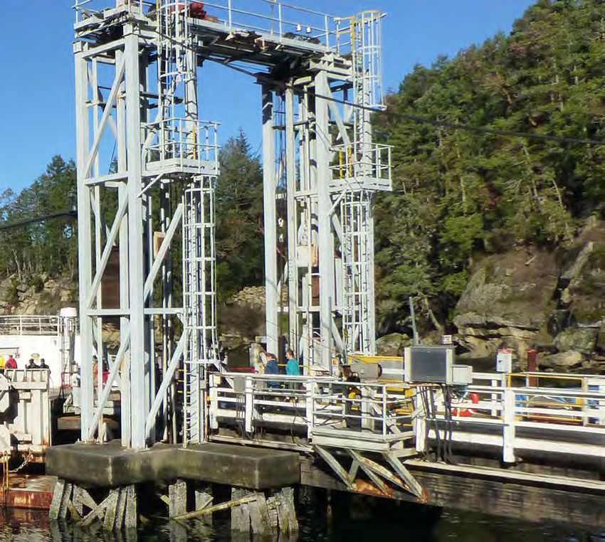
4.1.2 BERTHS
Site Specific Requirements:
The berth is compatible with the existing vessel (Quinsam) and should be compatible with a future Island Class
vessel as set out in the 2018 Fleet Master Plan. This is essential to ensure safe, reliable and efficient operations
of the terminal.
Functional Requirements – Berths
Criteria TNMP Existing Functionality TDP Essential TDP Desirable
Requirements Functional Functional
Requirement Requirement
Number of 1 Berth The marine infrastructure at 1 Berth as per existing
Berths the Gabriola Terminal consists
of a single lane ramp supported
by towers with wingwalls on a
C-shaped pontoon. There are
2 port side floating leads and 1
starboard side fixed dolphin.
Berth Minor/ Minor/Intermediate (MIM) To be compatible with the
Interface Intermediate existing vessel as well as the
(MIM) future replacement Island
Class vessel, scheduled to be
in service in F2022
Figure 15: Gabriola Terminal Berth
4.1.3 TICKETING & PRE-TICKET AREA
Functional Requirements – Ticketing & Pre-Ticket Area
Criteria TNMP Requirements Existing Functionality TDP Essential TDP Desirable
Functional Requirement Functional Requirement
Ticketing Function None required for a Minor/ Gabriola is a non-ticketing terminal As per existing
Intermediate Unstaffed terminal
Self-Ticket Kiosks None None N/A
Turnstiles at Embarkation and None None N/A
Fee Paid Entry Zone4.1.4 VEHICLE HOLDING AREAS
Site Specific Requirements:
There is currently no holding compound at Gabriola
terminal. Vehicles queue on the shoulder of the
approach road along North Road and Taylor Bay Road.
This is an MOTI road and BC Ferries has no jurisdiction
or agreements in place with MOTI for this road. A
dedicated vehicle holding compound is a requirement.
Figure 16: Queuing Traffic along Taylor Bay Road
Functional Requirements – Vehicle Holding Areas
Criteria TNMP Requirements Existing Functionality TDP Essential TDP Desirable
Functional Requirement Functional Requirement
Pre-ticket Area None None As per existing
Holding Capacity The AEQ capacity requirement for 0 AEQ Accommodate a holding area of at least 47 AEQ.
Gabriola is 1 x maximum vessel AEQ However, the shoulder of North Signage for vehicle holding will have to be clear
capacity. This equates to 47 AEQ to Road and Taylor Bay Road to ensure that self-sorting can be carried out,
ensure conformity with the future provides for 73 AEQ acknowledging that there is staff present at the
vessel requirements as outlined in terminal during the summer months to assist with
the design specifications of the Fleet vehicle staging, particularly when traffic is left over
Master Plan after a sailing
Lane Widths Lane widths are to be the same. No holding lane All lanes same widths (2.8 – 3.1 m) Additional vehicle staging
No delineation of commercial/priority and area to improve vessel loading
standard vehicles required efficiencies
29Gabriola TDP | 2018
4.1.5 VEHICLE LOADING & UNLOADING
Functional Requirements – Vehicle Loading & Unloading
Criteria TNMP Requirements Existing Functionality TDP Essential TDP Desirable
Functional Requirement Functional Requirement
Control Tower None None N/A Ensure good visibility of the
holding compound from the
vessel
Loading & Unloading Main Car Deck – Single Lane Single Lane. Traffic queues on Single lane Desirable for design to
the roadway and/or shoulder accommodate a double lane
of roadway, and proceeds from near berth to expedite loading
roadway to load. Off-loading the and unloading
vessel, traffic moves directly onto
the roadway.
4.1.6 CUSTOMER AMENITIES
Functional Requirements – Customer Amenities
Criteria TNMP Existing Functionality TDP Essential TDP Desirable
Requirements Functional Requirement Functional Requirement
Foot & Vehicle
Waiting Room / Lounges and Yes Yes – waiting room also has a small storage locker for One terminal building for waiting room,
Washrooms cleaning supplies washrooms and terminal storage
Separate building with men’s and women’s washrooms,
and accessible washroom
Satellite Washroom Building None None N/A
Covered Outdoor Waiting Space, Yes Yes – an outdoor area with a few benches Yes. Outdoor amenity space for customers
Seating & Picnic Tables comprising picnic benches, covered
waiting area and benches
Customer Service Counter None None N/A
Retail Facility Yes Pad with None Serviced retail Pad for 3rd party kiosk
services for 3rd
party kiosk
Public Notice Board Yes Yes – in the waiting room YesFigure 17: Gabriola Passenger Waiting and Washroom Building
are in need of replacement with a new Waiting room/
Washroom Building
Figure 19: Barrier free design and removal of curbs and barriers to improve safety should be incorporated into the design
Figure 18: Opportunity to improve pick-up drop‑off area for
Gabriola Community (Gertie) bus Figure 20: Pick-up and drop‑off area is congested and constrained
31Gabriola TDP | 2018
Functional Requirements – Customer Amenities
Criteria TNMP Existing Functionality TDP Essential TDP Desirable
Requirements Functional Requirement Functional Requirement
ATM None None N/A
Vending Yes Yes Yes – one vending machine in existing
terminal building
Distress Phones Yes None Yes – one distress phone in existing
terminal building
Water Fountains / Bottle Filling Yes if potable None – provisional water service provided Yes
Station water exists
Vehicle Only
Playground, Pet Areas None None N/A
Foot Passengers Only
Baggage Service (drop-off, handling None None None
and transport to vessel)
Escalator, Elevator None None None
Enclosed Walkway to Berths After None None None
Ticketing
Pick-up / Drop-off zone Yes No designated pick-up/drop-off area. Limited area inside Yes dedicated pick-up/drop-off area
parking lot to pick-up/drop-off to be located near waiting room and a
dedicated community bus stop adjacent
to the waiting room
Parking Yes No short-term parking available within the terminal. 8–10 short-term parking stalls
Passengers often leave their cars on adjacent side- Long-term parking if space
streets which limits parking availability for customers of available
nearby businesses
No long-term parking available within the terminal
Passengers often leave their cars on adjacent side-
streets which limits parking availability for customers of
nearby businesses. However, there is a pay and display
parking lot a short walk from the terminal.
Bus Bays Yes, large school There is a dedicated bus area for the Gertie Community Yes, a Gertie Community Bus bay in
bus bus and the school bus the compound and a School Bus bay on
Easthom Road4.1.7 COMMUNICATIONS &
IT INFRASTRUCTURE
Site Specific Requirements:
Internet bandwidth is currently very limited at the
Gabriola site. It is likely that upgrades to the network
will need to be provided by the service provider
before Wi-Fi can be improved. It is recommended to
discuss this with the service provider to understand
feasibility and costs.
Functional Requirements – Communications and IT Infrastructure
Criteria TNMP Existing TDP Essential TDP Desirable
Requirements Functionality Functional Functional
Requirement Requirement
Wayfinding (static), Yes None An electronic real time
reader boards information sign
Public Address System None None Vessel equipped with
IT/wireless system for
announcements
Electronic Tollbooth None None N/A
Signage
Vehicle Classification None None N/A
System
Standard BC Ferries IT Yes Yes (IT equipment Yes
Systems & Capacities housed in electrical
and Server Room room)
Customer Wi-Fi Yes None Yes Coordinate with
communications provider
to upgrade internet
network to support
improved Wi-Fi capability
Figure 21: Customer Information Reader Board Sign Example
33Gabriola TDP | 2018
4.1.8 ADMINISTRATION & EMPLOYEE
FACILITIES
Site Specific Requirements:
Functional Requirements – Administration & Employer Facilities
Criteria TNMP Requirements Existing Functionality TDP Essential TDP Desirable
Functional Requirement Functional Requirement
Ticket Office None None None – as per existing
Admin Offices, Meeting Rooms and Crew Mess None Yes – located in waiting room None – as per existing
building
Crew, Employee and Visitor Parking Yes (except visitor parking) There are 16 crew parking spaces in 16 Parking Spaces Allow room for expansion in case
the ferry terminal parking lot new vessel requires more staff
Figure 22: Crew parking spaces are required at the terminal4.1.9 OTHER TERMINAL SERVICES
Site Specific Requirements:
Functional Requirements – Other Terminal Services
Criteria TNMP Existing TDP Essential TDP Desirable
Requirements Functionality Functional Functional
Requirement Requirement
Fleet Support Unit None None N/A
Warehouse / Cross None None N/A
Docking
Storage for Terminal Ops, Yes Yes – small shed for One larger storage
Terminal Maintenance bikes, small storage space for equipment,
and Fleet Ops area for snow blower and a separate storage
space for staff bicycles
Drop Trailer – Holding None None N/A N/A
Area, Vessel Staging Area
and Office
Simulator and Training None None N/A N/A
Room
Bicycle Access / Egress / Yes Yes – 2 bicycle racks, Additional bicycle Sufficient storage
Storage regularly used, and rack(s) and design / waiting space to
possibly fail to meet for covered space for accommodate seasonal
existing capacity bicycles and scooters bike tourists
Given the high number
of cycle tourists and
mountain bikers using
the ferry a bike repair
station would be useful
Figure 23: Install a covered bike stand at the terminal given the
high numbers of cycle commuters using the terminal
35Gabriola TDP | 2018
4.1.10 UTILITIES & MISCELLANEOUS
Functional Requirements – Utilities & Miscellaneous
Criteria TNMP Requirements Existing Functionality TDP Essential TDP Desirable
Functional Requirement Functional Requirement
Compactors Yes None Not required
Environmental & Containment Yes None Not required
for Hazardous Goods
Generators One to power CCTV except None. Ship powers ramp to vessel Accommodate generator to power terminal
where no night watch – vessel waiting room and lights, required if night
will power ramp watch is removed in future
Potable Water Supply Yes Yes – well water purchased from Source own water/well on nearby land
nearby property owner - pumped
directly from well to the terminal
Septic Field or Sewage Treatment Yes Yes – sewage contained in a holding Septic field or connect to community/
System, or Conveyed to Sewer tank and is pumped ashore in Nanaimo municipal sewage system if available
System where Possible Harbour
Pump Ashore Yes – where infrastructure No infrastructure exists – pumped at Septic field or connect to community/
exists Nanaimo Harbour municipal sewage system if available
Shore to Ship Power Yes – at home ports only Yes – 600V/200A Requires 600V/300A
Ship to Shore Power Yes Yes Yes – as per existing
Figure 24: Implement sustainable storm water bioswales/rainwater
gardens to deal with storm water run-off where possible5 PLAN CONCEPTS
The concept plans have been prepared after careful Long-Term Improvements • Provisions for community bus parking and pick-
consideration of the issues identified in the supporting In the long‑term a new roundabout could be up drop‑off
baseline report and have been influenced by the implemented to improve traffic flow at the terminal • Dedicated parking for customers and vessel staff
functional requirements and comments received from and allow vehicles approaching from Easthom Road
• New waiting room/washroom building to
the internal Working Group and external stakeholders. to make a u-turn and join the back of the ferry queue
enhance customer experience
The plan concepts highlight key improvements that in the holding compound.
meet the functional requirements; it supports the • New dedicated covered bike parking
This plan also shows a queuing lane running from
goals of the Strategic Master Plans and ultimately These concept plans provide improvements over the
the terminal approximately 200 m to provide
meets the needs of terminal users. existing situation and while they address some of
56 additional AEQ.
the key issues and functional requirements of the
5.1 Concept Overview Key features: TNMP they do not address all the requirements due
to the limited landholding currently available.
Concept plans have been prepared to show how the • New sidewalks for improved foot passenger /
terminal could be improved over time as follows: pedestrian safety and accessibility of all ages Figures 25 to 31 show the illustrative 25 year concept
and abilities plans for the Gabriola Island terminal.
Immediate Actions
This plan includes improving signage and minor
• Improved and expanded vehicle holding
compound to reduce traffic backups and
modifications to the road layout to improve traffic
conflicts with thru traffic and neighbours and
safety at the terminal for those exiting and arriving
those accessing properties on Easthom Road
at the terminal.
• Dedicated thru lane for pick-up / drop-off traffic
Short Term Improvements directly to the new foot passenger terminal
Create a new holding compound to provide storage building
for at least 47 AEQ.
37Options Gabriola Island - Gabriola Terminal
Gabriola TDP | 2018
Traffic Safety Review
Options Gabriola Island - Gabriola Terminal P1-A | Use barrier
or curbs to dissuade
pick-ups here
P1-B | Provide pick-
up pullout
P2-A + C1-A | Provide multi-
X3-A | P1-A | Use barrier use path
Acquisition andor curbs to dissuade P2-B + C1-B | Provide
X2-A | Straighten grading pick-ups here
continuous paved shoulder
roadway alighment P1-B | Provide pick- (fill in gaps)
(requires property) up pullout
P2-A + C1-A | Provide multi-
X3-A | use path
X1-A | Clear foliage
Acquisition and P2-B + C1-B | Provide
X2-A | Straighten grading continuous pavedX1-B | Realign/
shoulder
roadway alighment (fill in gaps) straighten road
(requires property)
X1-A | Clear foliage
U1-A | Improve intersection
geometry and markings to
X1-B | Realign/
straightenaccommodae
road vehicle alignment
and swept path.
Interim: consider flexible bollards
U1-A | Improveor
intersection
pickets
X4-A | Provide centerline geometry and markings
Long-Term:to Raised islands or curbs
pickets accommodae vehicle alignment
Legend
and swept path.
X4-B | Provide formal u-turn S1-A
Interim: consider | Formalize
flexible bollards
L Loading
pull-out in each direction or pickets pedestrian route with
U Unloading
X4-A | Provide
with centerline
“U-turn Route to Ferry” crosswalk
Long-Term: Raised markings
islands or curbs and
S Signs & Markings pickets C2-A | Provide
Legend signage signage
P Pedestrian accommodation for cyclists
X4-B | Provide formal u-turn S1-A | Formalize
LC Loading
Cyclist (i.e. bike lane at terminal) S1-B | Provide pedestrian
pull-out in each direction pedestrian route with
UX Unloading
Other
with “U-turn Route to Ferry” crosswalk markings andareas at
staging
S Signs & Markings C2-A | Provide intersection corners
signage signage
P Pedestrian accommodation for cyclists
C Cyclist (i.e. bike lane at terminal) S1-B | Provide pedestrian
X 25:
Figure Other
Traffic Safety Review Short Term Recommendations staging areas at
intersection corners
Project No: 2245 | Date: December 11, 2017 | Drawn: VN SINCE 1983 F
CONSULTING GROPIC
K-U
P/D
RO
P-O
FF
HOLDING LANES
PA M/C
RK
= 53 AEQ
IN
G
PARKING:
21 - PARKING STALLS
6 - MOTORCYCLE/SCOOTER
5 - PICK-UP/DROP-OFF
1 - COMMUNITY BUS
1 - SCHOOL BUS
SH
OU
LD
ER
HO
LD
ING
LA
NE
OPTIONAL ROUNDABOUT SUBJECT TO MOTI DECISION
REVISED WAITING ROOM LAYOUT 19/01/28 DS
GABRIOLA
REVISED PARKING LAYOUT 19/01/02 DS
ADDED RETAINING WALL 18/11/05 DS
TERMINAL DEVELOPMENT
Figure 26: Illustrative Concept Plan for Gabriola Terminal
WIDENED EXIT SHOULDER 18/10/25
REVISED PARKING, BASE FROM DWG SK005d
DS
18/10/18 DS REVISED PARKING LAYOUT 19/01/31 DS
British Columbia OPTION 5 - PARKING REVISION
Ferry Services Inc. SITE PLAN GAB-TDP-SK005-1 F
39Gabriola TDP | 2018
PI
CK
-U
P/
DR
OP
H
-O
FF
PA M/
RK C
IN
G
R
Figure 27: Illustrative Concept Plans for Pick-Up/Drop-Off Area5.2 Illustrative Waiting Room • A flat slab of local sandstone sits at the entry • A green roof is used to strengthen the natural
plaza, a homage to the local geology and the appearance and function of the building. The
Washroom Building Design site’s history as a quarry for millstones. green roof will also aid in managing rainwater
The proposed building design incorporates the • An open-air portal creates a sheltered place to runoff and will slope towards a bioswale that
following functional objectives: wait, and frames views of Descanso Bay and the will filter site runoff before draining into the
incoming ferries. bay’s marine ecosystem.
• Building for foot-passenger use that includes
waiting room and washroom facilities • The small, but inviting waiting room has a The building also provides a generous list of
display area for local artists, and a long wooden amenities to better serve passengers and the
• Storage area for BC Ferries equipment and
counter to charge your device, or have a community:
supplies
conversation with a neighbour.
• Staff area for BC Ferries employee • Covered bike parking with charging stations
• A generous covered bike parking area is
• Outdoor uses including drop-off, bike parking, oversized to create an area for local artisan • Device charging receptacles within the waiting
and covered areas vendors. area
• Signage is integrated into the building and • A variety of indoor and outdoor seating options
5.2.1 DESIGN RATIONALE
designed to be readable from afar. In particular • A covered vendor space
The building, that sits gently along the shore of
Descanso bay at the mouth of Fiddlehead creek,
GABRIOLA ISLAND is visible from the ferry • Real-time display of vessel status
upon arrival, celebrating this moment, and also
is an important structure. It forms a point of serving a practical function for visitors who may
• Barrier free washrooms that include change
arrival and departure for the daily commuters of tables
not be familiar with the island geography.
Gabriola heading to Nanaimo, and summertime • Fresh water bottle filing station
The materials for the building are simple and
visitors too. The building must of course support
durable:
• Area for indoor and outdoor art display
all of the functional objectives of a ferry terminal,
• Community display board
creating efficient passenger flows, places to store • A solid mass-timber structure is supported by
maintenance supplies, good lighting etc. But the bearing walls and galvanized steel columns. The building design attempts to balance two primary
hope that this little building can be something more. The exposed wood soffit creates a warm and objectives:
We wanted to create a building that speaks to the
unique qualities of the island.
inviting environment, while the galvanized steel
• Create a durable, efficient structure that
columns provide a robust, durable solution.
becomes an integral component of the BC
• A long horizontal roof, covered in plants, creates • The exterior is wrapped in a prefinished metal Ferries transportation infrastructure.
ample covered spaces, and blends with the cladding system providing a low-maintenance
• Create a building for the people of Gabriola. A
surroundings when viewed from above—both exterior skin. Facing the parking area, a 6mm
place for locals to meet, for tourists to arrive,
by vehicle approach from North Road, and on metal fins project past the face of the building
and that the community can be proud of.
the upper deck of the ferry. and create an opportunity for color and indirect
lighting to illuminate the facade at night.
41You can also read