Tronox Fairbreeze Mine Biodiversity Offset - SRK Consulting
←
→
Page content transcription
If your browser does not render page correctly, please read the page content below
Fairbreeze Mine Offset: Catchment Rehabilitation & Management Strategy   Sep. 2020

   Tronox Fairbreeze Mine Biodiversity Offset

                REHABILITATION PLAN FOR THE
            ‘SIYAYA PLANTATIONS OFFSET AREA’

   Catchment Rehabilitation & Management
                 Strategy

                                  Version 1.0
                                   (Revision 0)

                       Date: 16th September 2020

          Eco-Pulse Environmental Consulting Services

                             Report No: EP320-03E

      i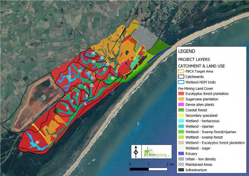
Fairbreeze Mine Offset: Catchment Rehabilitation & Management Strategy                        Sep. 2020

Prepared by:              Eco-Pulse Environmental Consulting Services

                          26 Mallory Road
                          Hilton
                          3245
                          South Africa
                          Tel: 033 343 3651
                          E-mail: dmacfarlane@eco-pulse.co.za

Prepared for:             Tronox KZN Sands (PTY) Ltd

                          Private Bag X20010
                          EMPANGENI
                          3880
                          Tel:    035 3408103
                          Fax:    035 3408167

Suggested report citation:

Eco-Pulse, 2020. Tronox Fairbreeze Mine Biodiversity Offset, Siyaya Plantations Offset Area: Catchment
Rehabilitation Strategy. Report prepared by Eco-Pulse Environmental Consulting Services for Tronox KZN
Sands, as part of the planning phase for the Fairbreeze Mine Biodiversity Offset. Version 1.0 (rev 0). Report
No. EP320-03E. 16th September 2020.

        ii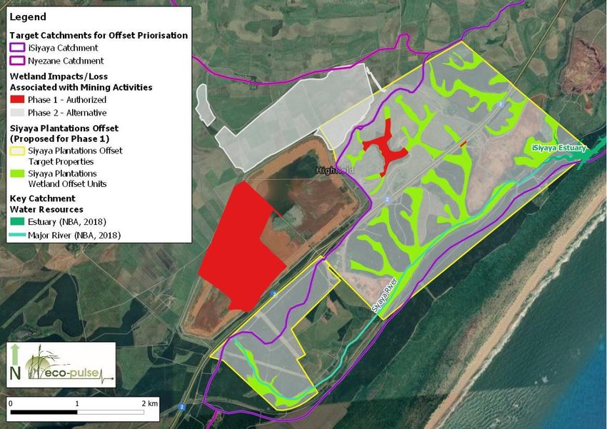
Fairbreeze Mine Offset: Catchment Rehabilitation & Management Strategy                      Sep. 2020

      REPORT DETAILS AND DECLARATION OF INDEPENDENCE
This is to certify that the following monitoring plan has been prepared independently of any influence or
prejudice as may be specified by the relevant provincial or national assessing authorities.

                                      Tronox Fairbreeze Mine Biodiversity Offset, Siyaya Plantations Offset
    Document Title:
                                      Area: Catchment Rehabilitation Strategy
                                      Douglas Macfarlane Pr.Sci.Nat. (Eco-Pulse)
                                      Adam Teixeira-Leite Pr.Sci.Nat. (Eco-Pulse)
    Contributing authors:
                                      Juliette Lagesse (Eco-Pulse)
                                      David Styles Pr.Sci.Nat (Botanist, subcontracted)
    Date:                             16th September 2020
    Report Ref:                       EP320-03E
    Version Number:                   1.0
    Revision Number:                  0
    Client:                           Tronox KZN Sands

                                            DISCLAIMER
o      This Catchment Rehabilitation Strategy has been drawn up for sole use in the proposed ‘Siyaya
       Plantations Wetland Offset’ project located at Fairbreeze Mine, Mtunzini, KwaZulu-Natal. Neither its
       guidelines/recommendations nor background information may be used in any form without prior
       permission from Tronox KZN Sands.
o      This document must not be amended without prior consultation and approval from Tronox KZN Sands.
o      All changes must be formally motivated and supplemented with additional information as necessary.

                            ASSUMPTIONS AND LIMITATIONS
In compiling this document, the following has been assumed:

o      The information provided in this report is based on site visits that have been undertaken by the
       project team (Ecologists from Eco-Pulse Consulting and subcontracted Botanist, David Styles) and
       their subsequent input into the reporting, which includes baseline assessments.
o      Information contained in this document will be used to inform the rehabilitation and management
       of the terrestrial vegetation and habitat in the catchment areas of wetlands located in the ‘Siyaya
       Plantations Offset Area’ and to guide the development of a relevant rehabilitation plan and
       programme.
o      The implementation of this strategy must consider all relevant recommendations of the
       Environmental Authorisation (EA) and Water Use License (WUL) for the Siyaya catchment biodiversity
       offset.
o      The information in this report is based on existing available information and input from the ecologists
       from Eco-Pulse Consulting and subcontracted botanist, David Styles. Until this strategy has been
       finalised and signed off by Tronox KZN Sands and accepted by the relevant environmental
       authorities, the content of the document should be considered as preliminary (draft form).

              iii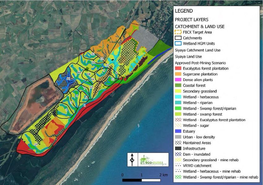
Fairbreeze Mine Offset: Catchment Rehabilitation & Management Strategy                                                                            Sep. 2020

                                                                      CONTENTS
1      INTRODUCTION ............................................................................................................................................... 1
    1.1      BACKGROUND ............................................................................................................................................. 1
    1.2      PURPOSE OF THIS REPORT ............................................................................................................................... 4
    1.3      REPORT CONTENT & STRUCTURE ...................................................................................................................... 4
2      BACKGROUND INFORMATION ...................................................................................................................... 4
    2.1      INTRODUCTION TO GRASSLAND ECOSYSTEMS..................................................................................................... 4
    2.2      FUNCTIONAL VALUE OF GRASSLAND ECOSYSTEMS.............................................................................................. 5
    2.3      GRASSLANDS IN SOUTH AFRICA: NATIONAL & PROVINCIAL PERSPECTIVES .............................................................. 6
3      BASELINE GRASSLAND ASSESSMENT ............................................................................................................. 7
    3.1      PURPOSE ..................................................................................................................................................... 7
    3.2      APPROACH AND METHODS ............................................................................................................................ 7
    3.3      ASSUMPTIONS AND LIMITATIONS....................................................................................................................... 9
    3.4      DESKTOP REVIEW OF ECOLOGICAL/CONSERVATION CONTEXT ............................................................................ 9
    3.5      RAPID BASELINE ECOLOGICAL ASSESSMENT .................................................................................................... 11
    3.6      BASELINE ASSESSMENT SUMMARY ................................................................................................................... 20
4      CATCHMENT REHABILITATION & MANAGEMENT STRATEGY ...................................................................... 22
    4.1      DESIRED STATE ............................................................................................................................................ 22
    4.2      REHABILITATION STRATEGY ............................................................................................................................ 22
5      TRAJECTORY OF CHANGE & ANTICIPATED ECOLOGICAL GAINS............................................................. 23
    5.1    HABITAT PROVISION AND IMPROVED CONNECTIVITY ......................................................................................... 24
    5.2    MITIGATING IMPACTS FROM CURRENT LAND-USES ............................................................................................ 25
      5.2.1     Mitigating Catchment Hydrological Impacts ............................................................................ 25
      5.2.2     Mitigating Sedimentation Impacts .............................................................................................. 26
6      MONITORING RECOMMENDATIONS ........................................................................................................... 27
7      REFERENCES .................................................................................................................................................. 28
8      ANNEXURES................................................................................................................................................... 31
    ANNEXURE A. PLANT SPECIES LIST ............................................................................................................................ 31
    ANNEXURE B. NEGATIVE IMPACT OF PLANTATION FORESTRY ON CATCHMENT HYDROLOGY .............................................. 35

                                                      RELATED DOCUMENTS
This ‘Catchment Rehabilitation Strategy’ (for terrestrial areas in the catchment of wetlands forming part
of the biodiversity offset for Fairbreeze Mine) must be read in conjunction with the ‘Wetland Rehabilitation
Plan’ for the ‘Siyaya Plantations Offset Area’, which is cited below:

       •     Eco-Pulse & Ground-Truth, 2020. Fairbreeze Mine: Wetland Offset Rehabilitation Plan for the Siyaya
             Plantations Offset Area. Report prepared by Eco-Pulse Environmental Consulting Services in
             association with Ground-Truth for Tronox KZN Sands, as part of the planning phase for the
             Fairbreeze Mine Biodiversity Offset. August 2020. Report reference No. EP320-03.

            iv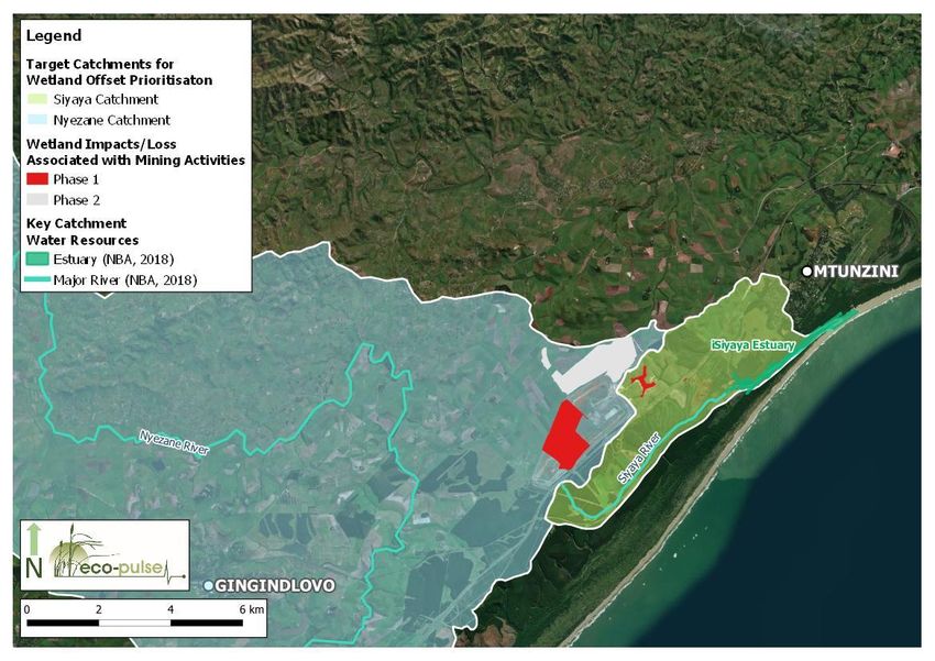
Fairbreeze Mine Offset: Catchment Rehabilitation & Management Strategy                        Sep. 2020

                                     1 INTRODUCTION

1.1 Background
Environmental Authorization (EA) for the construction of the Tronox KZN Sands (‘Tronox’) Fairbreeze Mine
and related activities was granted and included approval for the mine’s EMPr (Environmental
Management Programme, dated February 2012) which needs to be implemented as a condition of the
EA. The EMPr includes specific requirements to manage and monitor biodiversity offsets according to an
offset management plan. Despite initial progress towards meeting existing offset commitments at the
Fairbreeze Extension C (FBCX) offset site, which has already obtained authorisation and a water use
license, the identification of additional sites was still required to meet residual offset targets associated
with the mine and proposed Valley Return Water Dam (VRWD) expansion and ERSF (Everglades Residue
Storage Facility).

Figure 1.   Location and extent of current (Phase 1 – shown in red) and anticipated (Phase 2 shown in
            grey) wetland loss associated with mining activities, in relation to the town of Mtunzini and
            key water resources within the affected catchment areas.

To this end, Tronox has purchased properties from Mondi (previously commercial Eucalyptus plantation)
to secure additional wetland offset receiving areas in the catchment of the Siyaya River and estuary, to
contribute towards meeting Tronox’ revised offset commitments. Eco-Pulse Environmental Consulting
Services (‘Eco-Pulse’) developed an offset management and wetland rehabilitation plan for the Siyaya
Plantations Wetland Offset Area. Part of the offset includes the rehabilitation of several degraded
wetland areas and detailed wetland rehabilitation plans have already been compiled for the Siyaya
plantations offset area to accomplish this (refer to map in Figure 2).

        1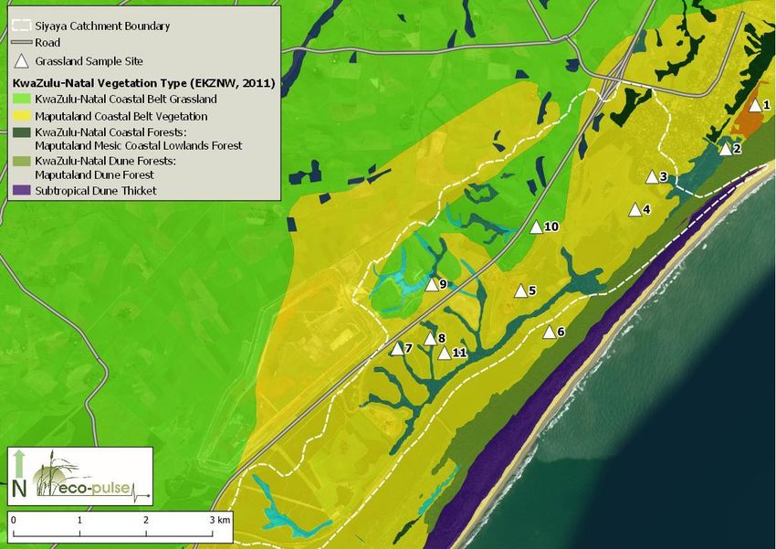
Fairbreeze Mine Offset: Catchment Rehabilitation & Management Strategy                           Sep. 2020

Figure 2.   Map indicating the location of the existing Siyaya Plantations offset wetland units in relation
            to existing (Phase 1) and planned mining activities (Phase 2).

The Siyaya Plantations Offset developed to compensate for wetland losses, involves not only the
rehabilitation of wetland areas on target offset properties, but also includes the rehabilitation of terrestrial
vegetation on the target properties (i.e. former KwaZulu-Natal Coastal grassland and Maputaland
Coastal Grassland which have been transformed and almost entirely converted to commercial timber
plantations, formerly under ownership and management by Mondi). The anticipated situation under the
post-mining rehabilitation scenario, relative to pre-mining, would see the area under Eucalyptus timber
plantation massively reduced from 48% of the Siyaya catchment (809 ha) to 10% (163 ha) and sugar
cane from 17% (285 ha) to 11% (180 ha), with the secondary and/or rehabilitated terrestrial vegetation
set to increase from 2% (37 ha) to 43% (728 ha) of the catchment (refer to the maps in Figures 3 and 4
showing the pre and post mining catchment land use and vegetation types).

Removal of forestry plantations from the target properties was identified as key to achieving offset targets
as considerable gains in terms of functional wetland enhancement and ecosystem protection are
anticipated from this landscape scale approach that would seek to reinstate wetland hydrological
drivers to a large extent. In particular, it is hypothesized that collective rehabilitation efforts on target
properties could potentially turn the trajectory and health status of the iSiyaya estuary downstream from
a low E to a high C or low B and would be a highly significant restoration initiative for this area of the
coastline (MER, 2020). It should be noted that this is under the caveat that all proposed rehabilitation
measures are implemented, and a best-case rehabilitation scenario achieved.

        2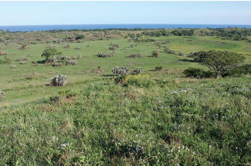
Fairbreeze Mine Offset: Catchment Rehabilitation & Management Strategy   Sep. 2020

Figure 3.   Map showing the pre-mining landcover and vegetation types.

Figure 4.   Map showing the post-mining landcover and vegetation types.

        3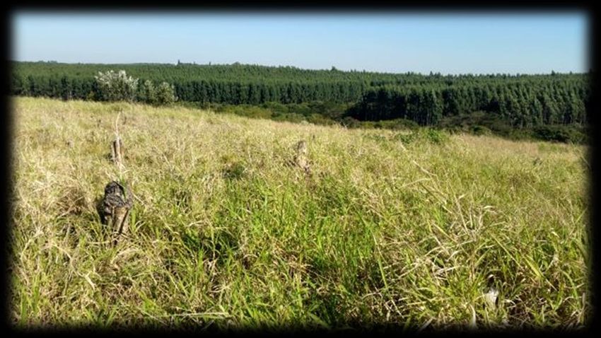
Fairbreeze Mine Offset: Catchment Rehabilitation & Management Strategy                       Sep. 2020

1.2 Purpose of this Report
Although the offset targets for Phase 1 have been finalised and agreed to and the offset plan for the
Siyaya Plantations Offset Area has been largely finalised, offset planning for the Tronox Fairbreeze Mine
is still ongoing for Phase 2 of proposed mining activities and involves consultation and feedback from the
Offset Advisory Committee for the project. Feedback from Ezevemvelo KZN Wildlife (EKZNW) as part of
this consultation process indicated that more clarity was required regarding the potential benefits
associated with secondary grassland establishment on the Siyaya Plantations Offset properties in order
to inform decision-making with regards to offset options for Phase 2 of mining activities. Moreover, more
guidance for the management of grassland areas following the removal of timber plantations and sugar
cane from target properties was identified as key supplementary information needed for the existing
Siyaya Plantations Offset Plan.

Therefore, as part of the ongoing offset planning process, management of grassland areas in the Siyaya
catchment and their potential value in terms of (i) providing increased levels of functionality to
downstream wetland offset sites and (ii) their potential habitat and biodiversity contributions were
flagged for further investigation.

This report then essentially serves as a supplementary strategy (Appendix E) to the Wetland Rehabilitation
Plan developed for the Siyaya Plantations Offset Area (Eco-Pulse, & Ground Truth, 2020). It seeks to
provide clarity on the potential benefits associated with secondary grassland establishment and to
provide guidance for the establishment and management of terrestrial grassland areas following
plantation / sugarcane removal from the target wetland catchment areas which also has relevance for
the FBCX Offset Area.

1.3 Report Content & Structure
The report provides a brief introduction to grasslands and presents the ecological state of secondary
grassland areas currently owned by Tronox, as well as older historically disturbed sites in the larger study
area around Mtunzini town, in order to appraise their levels of recovery and anticipated trajectory of
future change. Thereafter, near-term management objectives/recommendations for these targeted
secondary grassland sites are outlined and a longer-term monitoring framework is provided to facilitate
an adaptive management approach which aims to guide the trajectory of secondary grassland areas
towards the best practical rehabilitation state.

                        2 BACKGROUND INFORMATION

2.1 Introduction to Grassland Ecosystems
Grasslands are deemed to be among the most biodiverse vegetation types on the planet and are
reported to play host to more plant species at a fine spatial grain than tropical rainforests and the
floristically diverse sclerophyllous fynbos of the south-western Cape (Scott-Shaw & Morris, 2015). “Many of
the world’s grasslands are ancient ecosystems composed of communities that require centuries to
assemble and perennial plants capable of living for decades to millennia” (Veldman et al. 2015). These
ancient ecosystems have in the past and are currently being lost to agriculture, tree plantations, mining
and urban sprawl (Veldman et al. 2015; Parr et al. 2014). According to these authors, remaining
grassland ecosystems are threatened by degradation in the form of alien plant invasion, poor domestic
livestock management, altered fire regimes, elevated atmospheric carbon dioxide and nitrogen
deposition. According to Veldman et al. (2015), until recently the value of ancient grassland ecosystems
and their rich level of herbaceous plant diversity has been overlooked, largely due to a lack of

        4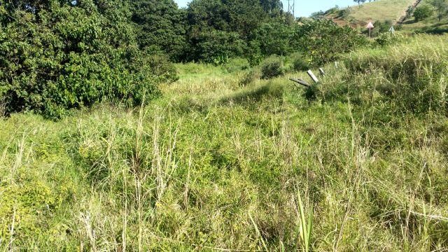
Fairbreeze Mine Offset: Catchment Rehabilitation & Management Strategy                          Sep. 2020

understanding and research regarding the substantive differences between natural grassland
ecosystems and their altered anthropogenic counterparts.

Natural grassland ecosystems are characterised by a high level of forb diversity, which contribute the
bulk of the total plant species richness in these ecosystems with grass species contributing 20% or less of
the species richness, despite comprising the majority of the phytomass (Scott-Shaw & Morris, 2015).
Globally and within southern Africa there has been a greater level of research focus on the autecology
and community compositional response of grass species deemed important for livestock production
(O’Connor et al. 2010; Scott-Shaw & Morris, 2015), and conversely, grassland forbs have been largely
understudied or overlooked due to their low value as forage for livestock in grazed natural grasslands.
As a result, very little is known about the possible functional roles of grassland forb species and the
potential ecological consequences of any depletion of populations of forb species. This has
unfortunately translated into a lack of concern over the anthropogenic impacts that have caused forb
biodiversity loss in these important ecosystems (Veldman et al., 2015). To promote the recognition and
conservation of natural grasslands, authors such as Veldman et al. (2015) propose extending the term
“old growth”, which is widely used to refer to intact ancient forest ecosystems, to intact ancient grassland
ecosystems, which will aid in distinguishing ecosystems with high conservation value and unique
ecological attributes from grassland vegetation that forms over short timescales in response to human
land uses, which has been referred to as “secondary grassland” communities in this report.

There is a growing body of literature supported by empirical evidence that lends strength to the argument
that conserving plant species diversity contributes to the sustained functioning of healthy ecosystems;
with high levels of species richness linked to improving a number of ecosystem functions related to the
use, storage and cycling of nutrients in dry rangelands and serving as a measure of ecosystem resilience
against climate change and desertification (Scott-Shaw & Morris, 2015). Consensus between several
individual experiments and meta-analyses is that loss of individual plant species, even rarer ones, will
reduce overall productivity stability and efficiency of ‘Ecosystem functions’ and the ability of vegetation
to sustain the delivery of various regulatory and provisioning ecosystem services (Scott-Shaw & Morris,
2015).

Given that grassland ecosystems are considered one of the most threatened ecosystems there is an
urgent need to first and foremost conserve and secondly attempt to restore old growth grasslands – not
only to preserve their biodiversity but also to concurrently retain their invaluable contributions with regards
to provisioning and regulatory ecosystem services.

2.2 Functional Value of Grassland Ecosystems
Globally, grasslands cover close to one-third of the Earth’s terrestrial landscapes and the important
ecosystem services they supply represent invaluable environmental, economic and cultural values
(Bengtsson et al., 2019; Zaloumis, 2013; O’Connor & Kuyler, 2009; Overbeck et al., 2007). However, their
extent and condition are in decline worldwide, with 60% of the biome in southern Africa already
irreversibly transformed (Bengtsson et al., 2019). Moreover, grasslands are still undervalued or overlooked
in the paradigm of ecosystem service provision and have received less attention in the literature in
comparison to other production systems such as forest and cropland (Bengtsson et al., 2019).

At the local scale grasslands contribute to food production and biodiversity maintenance, while at the
landscape scale they are known to contribute to pollination, water regulation and recreational services
and potentially climate regulation at the global scale (although their role in climate regulation and
carbon sequestration still needs to be further investigated and more clearly defined with regards to how
they fit into global carbon and energy cycles) (Bengtsson et al., 2019; Zaloumis, 2013).

Grasslands are important water production landscapes as they contribute significantly to maintaining
the quality and quantity of water entering rivers, streams and ground water aquifers (SANBI, 2013). The
herbaceous vegetation within grassland environments is effective at capturing water and optimising
infiltration rates, thereby limiting surface run-off and reducing soil loss via erosion (SANBI, 2013).

        5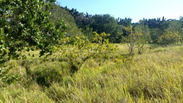
Fairbreeze Mine Offset: Catchment Rehabilitation & Management Strategy                            Sep. 2020

Consequently, grasslands are capable of enhancing and regulating stream flow by retaining water within
their soil profile and gradually releasing this water into downstream streams and rivers through diffuse
percolation and sub-surface flow which often ensures that base flows within these water resources are
maintained during the dry season (SANBI, 2013). Moreover, by decreasing rates of surface runoff and the
velocity of flows, grassland vegetation provides valuable flood attenuation services during high rainfall
events (Bengtsson et al., 2019).

Within South Africa the value of grassland ecosystems with regards to regulating water supply is
particularly pertinent, given the semi-arid climate and the fact that South Africa is already a water-scarce
country. According to SANBI (2013), “Grasslands comprise more than half of the Strategic Water Source
Areas of the country – areas that cover less than 5% of South Africa’s land surface, but that receive the
majority of its rainfall, and yield more than 80% of all water run-off. At least five major river systems have
their headwaters in grasslands, and 34% of the country’s remaining wetlands occur in grassland
landscapes.”

Over the course of the next 20 years water demand in the country is projected to rise by roughly 50%,
which will likely be compounded by unsustainable land-uses, additional loss of old-growth grassland
habitat and the effects of climate change (SANBI, 2013). In this context, rehabilitation and maintenance
of healthy grasslands and associated freshwater ecosystems represents one of many potential solutions
desperately needed to strengthen South Africa’s water security (SANBI, 2013).

2.3 Grasslands in South Africa: National & Provincial Perspectives
Grasslands within South Africa are poorly protected, with only 2% statutorily conserved in various
protected areas and with the majority of these being a small fraction falling within the Drakensburg
Transfrontier Park (O’Connor et al., 2010). Consequently, conserved grasslands fall far short of
representing the range of grassland types that occur in the country.

KwaZulu-Natal, as with many other parts of South Africa, is experiencing a rapid rate of habitat loss, which
raises questions generally about whether sustainable resource extraction can be achieved while
retaining a reasonable degree of ecosystem functioning, biodiversity and resilience (Jewitt, 2017). Within
the province, grassland and savanna ecosystems (which comprise the majority of the land cover) have
been largely transformed with a significant proportion of the remaining grass-dominated ecosystems
being secondary or degraded vegetation communities, while “old growth” grasslands form a small
fraction of the extant landcover (Jewitt, 2017). Furthermore, there is a paucity of empirical baseline data
and records available that documents shifts in forb diversity in these grassland ecosystems from reference
conditions, leading to a high degree of uncertainty regarding the extent of forb species loss that has
already occurred (for example Zaloumis et al., 2008 ; Styles, 2017).

In addition to insufficient baseline data, there is also a large degree of uncertainty relating to grassland
restoration, both abroad and in the South African context, in particular, with regards to restoring the high
level of forb diversity characteristic of “old growth” grassland systems (Prober & Thiele, 2005; Zaloumis et
al., 2008 ; Zaloumis, 2013). Studies that have interrogated this challenge have concluded that grassland
restoration is more complex than originally conceived and that passive restoration of grassland systems
is unlikely to yield success in restoring the level of floral diversity observed in intact systems, with the need
to investigate various avenues of active restoration identified as a key knowledge gap to be filled in
future (Zaloumis et al., 2008 ; Zaloumis, 2013).

Although the rehabilitation of degraded/transformed grasslands does not restore similar levels of plant
diversity, secondary grassland areas have been highlighted as essential for the provision of various
supporting and regulating services; that at a landscape scale, can contribute to the resilience of
grassland habitat networks namely by providing faunal movement corridors, enhancing nutrient cycling,
carbon storage and water regulation processes while also providing tourism and recreational
opportunities and resources such as medicinal plants, fibres for crafts and thatching, forage for livestock
and some edible food sources (SANBI, 2013 ; Bengsston et al., 2019).

        6
Fairbreeze Mine Offset: Catchment Rehabilitation & Management Strategy Sep. 2020
Taking into consideration the above context, the rehabilitation of grassland ecosystems within the Siyaya
catchment represents a key opportunity to enhance ecosystem service provision and conservation
outcomes in the Siyaya catchment.
3 BASELINE GRASSLAND ASSESSMENT
3.1 Purpose
A rapid-level baseline grassland survey and ecological assessment of secondary grassland areas
currently owned by Tronox, as well as older historic sites in the larger study area around Mtunzini town,
was undertaken, the purpose being to appraise their recovery and potential trajectory of change so as
to inform the catchment rehabilitation and management strategy for the Fairbreeze Mine biodiversity
offset.
3.2 Approach and Methods
A total of eleven (11) grassland sites, eight (8) located on Tronox owned properties and three (3) providing
examples of passive recovery on adjoining land, were selected for investigation. These sites ranged in
age since anthropogenic disturbance from 2 to ~30 years of passive regeneration/recovery (see Figure
5). The following information was recorded for each site:
• History of disturbance (based on available information and evidence on site);
• Recovery time (e.g. >20 years, 5-10 years etc.);
• Dominant grass, forb & woody species;
• Ecological condition (with reference to Table 1 below); and
• Illustrative site photo.
Table 1. Description of ecological condition classes assigned to the sampled grasslands.
Class Description Sub-Class Description Indicators
Unmodified. No • Characterised by native flora typical
significant changes in of reference sites.
Natural composition, • Structural characteristics resemble
structure or function that of reference plant communities.
Composition,
have taken place. • Low to no disturbances evident.
structure and
Small changes in
Good function are
composition and • A very minor change to vegetation
still intact or
structure may have composition is evident at the site.
largely intact.
Near natural taken place, but • Abundance of ruderal/pioneer
ecosystem functions species is slightly higher than natural.
are essentially • Limited disturbances evident.
unchanged.
• Natural vegetation composition has
been moderately altered.
Ecological • Introduced alien and/or increased
function is Ecological function is ruderal/pioneer species are still
maintained predominantly clearly less abundant than native
Moderately
even though unchanged even species characteristic of the natural
Fair Modified/semi-
composition though composition species composition.
natural
and structure and structure have • Moderate change in structural
have been been compromised. characteristics (e.g. moderate
compromised increase / decrease in woody
plants).
• Moderate disturbances evident.
7Fairbreeze Mine Offset: Catchment Rehabilitation & Management Strategy Sep. 2020
Class Description Sub-Class Description Indicators
• Natural vegetation composition has
been largely altered.
• Introduced alien and/or increased
ruderal/pioneer species occur in
Loss of composition, approximately equal abundance to
Largely structure and the characteristic indigenous
Modified ecological function is species.
extensive. • High change in structural
Ecological
characteristics relative to reference
function has
plant communities.
been severely
• High levels of grazing / disturbance
compromised
Poor evident.
or lost in
• Natural vegetation composition has
addition to The ecosystem has
been substantially altered but some
structure and been modified
characteristic species remain.
composition completely, with an
• Vegetation consists mainly of
almost complete loss
introduced, alien and/or
Irreversibly of composition and
ruderal/pioneer species.
Modified structure. All or most
• Evidence of erosion / compaction
ecosystem function
based on reflecting high levels of
has been destroyed
disturbance.
and the changes are
• Evidence of recent transformation
irreversible.
(e.g. agriculture).
Based on their current ecological condition and informed by the botanist’s experience with grassland
rehabilitation at other sites in KwaZulu-Natal, near-term management recommendations were
recommended for each grassland site visited. ‘Old growth’ intact grasslands were used as the
benchmark or endpoint to inform near-term management recommendations. Reference vegetation
type descriptions from the literature have also been included to provide context with regards to the
desired trajectory for the catchment areas on Tronox owned land which are to be returned from
plantation forestry or sugarcane cultivation to grassland cover.
Mtunzini
Town
Fairbreeze
Mine
Figure 5. Map indicating the location of the eleven (11) sampled grassland sites in relation to wetlands
mapped in the Siyaya catchment area, Fairbreeze Mine and Mtunzini town.
8Fairbreeze Mine Offset: Catchment Rehabilitation & Management Strategy Sep. 2020
3.3 Assumptions and Limitations
The following limitations and assumptions apply to this report:
• All vegetation information recorded was based on the onsite observations of the authors and no
formal vegetation plot sampling was undertaken. Furthermore, the vegetation information
provided only gives an indication of the dominant and/or indicator species and only provides a
general indication of the composition of the vegetation communities. Thus, the vegetation
information provided has limitations for true botanical applications i.e. accurate and detailed
species lists and rare / Red Data species identification.
• This report deals exclusively with 11 sampling sites and the nature of terrestrial habitat and
ecosystems at these sampling sites and inferences made about the ecological condition of the
vegetation communities assessed was informed by selected variables sampled during two days
of rapid field based surveys, this limits the degree to which this information can be extrapolated
spatially and temporally (i.e. over seasons).
• Additional information used to inform the assessment was limited to data and GIS coverage’s
available for the Province at the time of the assessment.
• The accuracy of desktop species information is limited to historic data and available databases
for the area apply. Note that data and information obtained from published articles, reference
books, field guides, official databases or any other official published or electronic sources are
assumed to be correct and no review of such data was undertaken by Eco-Pulse.
• Field surveys and sampling of the vegetation and terrestrial habitat was undertaken in June 2020
(early winter), and therefore does not cover the full seasonal variation in conditions likely to be
present at the site.
3.4 Desktop Review of Ecological/Conservation Context
To inform the desired state and type of terrestrial vegetation that will be reinstated following the removal
of plantation forestry and other undesirable land uses/alien vegetation from wetland catchment areas,
anticipated ‘reference’ vegetation (pre-development state) was estimated as far as possible. Based on
the large-scale transformation of the terrestrial vegetation and habitat in the study area and surrounds
(due to sugarcane cultivation and plantation forestry land uses), the anticipated ‘reference’ vegetation
for the terrestrial areas in the catchment of wetlands was based on a review of available historical
imagery for the study area (dating back to 1937) and available reference sites in the coastal belt region:
i.e. at Amatikhulu Nature Reserve which is roughly 15 km to the south of Fairbreeze Mine). The study area
was historically dominated by terrestrial grassland (Figure 6) associated with the Maputaland Coastal Belt
and KwaZulu-Natal Coastal Belt Group Grasslands (‘Critically Endangered’ type in KZN). Grasslands in
this region are highly diverse and similar to the highest known for any other high rainfall grasslands in
eastern South Africa according to Scott-Shaw & Styles (2012). Bush clumps, consisting of small trees and
shrubs are also commonly dispersed amongst the grassland matrix within the coastal-belt sandy
grassland type (Scott-Shaw & Styles, 2012).
The probable reference grassland vegetation type is classified according to Mucina & Rutherford (2006),
with the following important/characteristic taxa being relevant:
Graminoids: Aristida junciformis subsp. galpinii (d), Digitaria eriantha (d), Panicum maximum (d), Themeda triandra
(d), Alloteropsis semialata subsp. eckloniana, Cymbopogon caesius, C. nardus, Eragrostis curvula, Eulalia villosa,
Hyparrhenia filipendula, Melinis repens.
Herbs: Berkheya speciosa subsp. speciosa (d), Cyanotis speciosa (d), Senecio glaberrimus (d), Alepidea longifolia,
Centella glabrata, Cephalaria oblongifolia, Chamaecrista mimosoides, Conostomium natalense, Crotalaria
lanceolata, Dissotis canescens, Eriosema squarrosum, Gerbera ambigua, Hebenstretia comosa, Helichrysum
cymosum subsp. cymosum, H. pallidum, Hibiscus pedunculatus, Hybanthus capensis, Indigofera hilaris, Pentanisia
9Fairbreeze Mine Offset: Catchment Rehabilitation & Management Strategy Sep. 2020
prunelloides subsp. latifolia, Senecio albanensis, S. bupleuroides, S. coronatus, S. rhyncholaenus, Sisyranthus imberbis,
Stachys aethiopica, S. nigricans, Vernonia galpinii, V. oligocephala.
Geophytic Herbs: Bulbine asphodeloides, Disa polygonoides, Hypoxis filiformis, Ledebouria floribunda, Pachycarpus
asperifolius, Schizocarphus nervosus, Tritonia disticha.
Low Shrubs: Clutia pulchella, Gnidia kraussiana, Phyllanthus glaucophyllus, Tephrosia polystachya.
Woody Climbers: Abrus laevigatus, Asparagus racemosus, Smilax anceps.
Small Trees & Tall Shrubs: Bridelia micrantha (d), Phoenix reclinata (d), Syzygium cordatum (d), Acacia natalitia, Albizia
adianthifolia, Antidesma venosum.
Photo A: Species-rich Sandy Coastal Belt Grassland in the Amatikulu Nature Reserve
(Source: Scott-Shaw & Styles, 2012).
Figure 6. Map showing the location of the 11 sampled grassland sites, with the Provincial Vegetation
Types (EKZWN, 2011) overlaid.
10Fairbreeze Mine Offset: Catchment Rehabilitation & Management Strategy Sep. 2020
3.5 Rapid Baseline Ecological Assessment
A brief description of each sampled grassland site along with an appraisal of the present ecological
condition of the grassland vegetation represented at each site is provided below. A plant species list
has been provided in Annexure A.
Site 1: Imperata cylindrica dominated on municipal land (>14 - 30 years
recovery)
Site 1 is located on municipal owned land, which based upon examination of aerial imagery was
previously under timber plantations in 1953 and is shown to be recovering in the 2006 imagery. Therefore,
it is likely that this site has been recovering for more than 14 years. The site was selected as an example
of longer-term passive recovery (i.e. only alien clearing and/or burning taking place) and is estimated to
have been recovering for ~14 – 30 years.
In terms of the vegetation encountered on site, it comprises damp grassland in which Imperata cylindrica
is dominant. Some wetland herbs are present (such as Dissotis canescens) and this area is closer to
vegetation in natural condition than most of the other sampling sites assessed. However, a process of
woody plant encroachment is underway with proliferation of pioneers such as Bridelia micrantha,
Macaranga capensis and Syzygium cordatum. It appears that inconsistent/insufficient burning has taken
place at this municipal site and therefore even after ~14 – 30 years of passive recovery the
grassland/semi-open vegetation present will be lost to bush encroachment if no burning takes place in
future and may not be possible to sustain even if a burning regime is implemented.
It should be noted that according to the provincial vegetation map the reference vegetation type for
this area has been classified as ‘Maputaland Coastal Belt Grassland’ with biogeographically important
and threatened/rare/endemic forb species not observed during the rapid site visit. Given that the site
exhibited a low level of diversity in comparison to reference old growth grasslands falling within the same
vegetation type, this site is considered to be moderately modified and at best in fair ecological condition,
despite a lower level of invasive alien plants observed, however is likely to decline in condition if not
properly managed and should no burning take place.
Photo 1: View of Site 1 with early swamp forest tree growth (trees such as young Bridelia micrantha) shown
scattered across the Imperata cylindrica dominated open grassland/woodland mosaic.
11Fairbreeze Mine Offset: Catchment Rehabilitation & Management Strategy Sep. 2020
Site 2: Imperata cylindrica dominated on municipal land (>14 - 30 years
recovery)
Site 2, as with Site 1, is located on municipal owned land which based upon examination of aerial
imagery was previously under timber plantations in 1953 and is shown to be recovering in 2006 imagery.
Therefore, it is likely that this site has been recovering for more than 14 years. The site was selected as an
example of longer-term passive recovery (i.e. only alien clearing and/or burning taking place) and is
estimated to have been recovering for ~14 – 30 years.
In terms of the vegetation encountered on site, it is also dominated by damp grassland in which Imperata
cylindrica is common with a small number of weedy indigenous herbs also present. Woody species are
likewise an issue at this site and burning would need to be implemented more diligently for grassland
areas to be maintained.
Given that the site exhibited a low level of diversity in comparison to reference old growth grasslands
falling within the same vegetation type (Maputaland Coastal Belt Grassland) this site, despite a lower
level of invasive alien plants observed is considered to be moderately modified and at best in fair
ecological condition, however is likely to decline in condition if no burning takes place.
Photo 2: View of Site 2, with low trees scattered across the Imperata cylindrica dominated open
grassland.
Site 3: Panicum maximum dominated on Tronox land (>14 years recovery)
Site 3 is situated on land owned by Tronox KZN Sands which based upon examination of aerial imagery
was potentially under sugar cane in 1953 and thereafter was planted to timber with half the site
subsequently felled and chipped and the other half grazed by horses. In 2006 the site is shown to be open
grassland recovering from the previous land-use history. Therefore, this site has been recovering for 14
years or more. The site has reportedly not been burned and is consequently shifting to a woodier
vegetation composition.
The remaining secondary grassland patches comprise a mixture of ruderal grass species such as Panicum
maximum with a very low level of forb diversity observed. The shrub/woody component of the vegetation
which covers most of the site is dominated by Chrysanthemoides monilifera.
12Fairbreeze Mine Offset: Catchment Rehabilitation & Management Strategy Sep. 2020
Given that the site exhibited a low level of diversity in comparison to reference old growth grasslands
falling within the same vegetation type (Maputaland Coastal Belt Grassland) this site, with some invasive
alien plants observed such as Chromolaena odorata and a high degree of woody encroachment is
considered to be largely modified and at best in poor ecological condition (if the management end-
point for this site is grassland vegetation). A decision should be taken whether to maintain this site in an
open state. If so, the grassland should be burned every year for 3 years before, on reassessment, reverting
to a 2-year burning cycle.
Photo 3: View of Site 3 showing a smaller patch of secondary grassland surrounded by a
Chrysanthemoides monilifera dominated woody shrubland.
Site 4: Imperata cylindrica dominated on Tronox land (>14 years recovery)
Site 4 is located on Tronox owned land which based upon examination of aerial imagery was potentially
under sugar cane. In 2006 the site is shown to be open grassland recovering from the previous land-use
history. Therefore, this site has been recovering for 14 years or more.
The remaining secondary grassland patches comprise a mixture of pioneer/ruderal grass species such as
Imperata cylindrica with a very low level of forb diversity observed. The shrub/woody component of the
vegetation which covers most of the site is dominated by Chrysanthemoides monilifera with scattered
woody cover including trees such as Brachylaena discolour.
Given that the site exhibited a low level of diversity in comparison to reference old growth grasslands
falling within the same vegetation type (Maputaland Coastal Belt Grassland) this site, with some invasive
alien plants observed such as Chromolaena odorata and a high degree of woody encroachment is
considered to be largely modified and at best in poor ecological condition (if the management end-
point for this site is grassland vegetation). The grassland should be burned every year for 3 years before,
on reassessment, reverting to a 2-year burning cycle.
13Fairbreeze Mine Offset: Catchment Rehabilitation & Management Strategy Sep. 2020
Photo 4: View of Site 4 showing a smaller patch of secondary grassland surrounded by a
Chrysanthemoides monilifera dominated woody shrubland with scattered tree cover.
Site 5: Panicum maximum dominated on Tronox land
Site 5 is situated Tronox owned land which is currently being actively mined.
Photo 5: View of Site 5 showing a secondary grassland dominated by Panicum maximum with various
invasive alien plants also observed (e.g. Tagetes minuta) in the foreground and current mining operations
in the background.
14Fairbreeze Mine Offset: Catchment Rehabilitation & Management Strategy Sep. 2020
Site 6: Panicum maximum dominated on Mondi land (>14 years recovery)
Site 6 is located on Mondi owned land which was previously under timber plantation. In 2006 the site is
shown to be open grassland recovering from the previous land-use history. Therefore, this site has been
recovering for 14 years or more. The site was selected as an example of longer-term passive recovery.
The remaining secondary grassland patches comprise a mixture of ruderal grass species such as Panicum
maximum with a very low level of forb diversity observed (mostly Helichrysum and Senecio species). The
shrub/woody component of the vegetation which covers approximately two thirds of the site is
dominated by Chrysanthemoides monilifera with scattered woody cover including trees such as
Brachylaena discolour, Searsia 15ebulosi and alien invasive escapees from adjacent forestry plantations
i.e. Eucalytpus sp.
Given that the site exhibited a low level of diversity in comparison to reference old growth grasslands
falling within the same vegetation type (Maputaland Coastal Belt Grassland) this site, with some invasive
alien plants observed such as Eucalyptus grandis and a high degree of woody encroachment is
considered to be largely modified and at best in poor ecological condition (if the management end-
point for this site is grassland vegetation).
Photo 6: View of Site 6 showing the secondary grassland community, dominated by Panicum maximum
with the ferns (e.g. Pellaea viridis) and ruderal herbaceous species such as Helichrysum cymosum in the
foreground and a Chrysanthemoides monilifera shrubland transitioning to coastal dune forest in the
background.
Site 7: Stenotaphrum secundatum dominated on Tronox land (>14 years
recovery)
Site 7 is on Tronox owned land which was previously under timber plantation. In 2006 the site is shown to
be open grassland recovering from the previous land-use history. Therefore, this site has been recovering
for 14 years or more.
The site comprised primarily indigenous pioneer tree cover with a small band of Stenotaphrum
secundatum-dominated grassland. Where dominant this grass is associated with low species diversity
and is not conducive to re-establishing of a more diverse species assemblage. Due to the extensive cover
15Fairbreeze Mine Offset: Catchment Rehabilitation & Management Strategy Sep. 2020
of indigenous pioneer trees, the only management decision that needs to be taken is whether to allow
it to succeed to woody vegetation or maintain it as more open habitat, in which case burning is essential.
Given that the site exhibited a low level of diversity in comparison to reference old growth grasslands
falling within the same vegetation type (Maputaland Coastal Belt Grassland) this site, with a high degree
of woody encroachment is considered to be largely modified and in poor ecological condition (if the
management end-point for this site is grassland vegetation). The grassland area should be burned every
year for 3 years before, on reassessment, reverting to a 2-year burning cycle.
Photo 7: View of Site 7 showing a patch of Stenotaphrum secundatum secondary grassland in the
foreground and indigenous pioneer trees in the background.
Site 8: Imperata cylindrica - Stenotaphrum secundatum dominated on Tronox
land (>14 years recovery)
Site 8 is located also Tronox owned land which was previously under sugar cane. In 2006 the site is shown
to be open grassland/woodland recovering from the previous land-use history. Therefore, this site has
been recovering for 14 years or more.
The site was characterised by more robust grass species including Panicum maximum, Imperata
cylindrica and Stenotaphrum secundatum. Herbaceous plants observed are considered ruderals or semi-
ruderals. Some expansion of woody plants into grassland is also evident.
Given that the site exhibited a low level of diversity in comparison to reference old growth grasslands
falling within the same vegetation type (Maputaland Coastal Belt Grassland) this site, with a low degree
of woody encroachment is considered to be moderately modified and at best in fair ecological
condition (if the management end-point for this site is grassland vegetation). It is recommended that
burning be diligently implemented. It would be worthwhile burning this grassland annually for 2-3 years
before moving to a 2-year cycle to reduce the amount of Panicum maximum and transform the grass
cover to smaller species.
16Fairbreeze Mine Offset: Catchment Rehabilitation & Management Strategy Sep. 2020
Photo 8: View of Site 8 showing ruderal and semi-ruderal herbs in the foreground and Imperata cylindrica
secondary grassland in the background.
Site 9: Secondary grassland on Tronox land (5 years recovery)
Site 9 is situated on Tronox owned land which was previously under timber plantation until 2015 when the
timber was felled, and the site left to recover. Therefore, this site has been recovering for 5 years.
This area did not contain a large amount of Panicum maximum, with other grass species such as
Sporobolus africanus, Sporobolus fimbriatus, Melinis repens and Digitaria eriantha also observed within
the secondary grassland at this site. Herbaceous plants observed are considered ruderals or semi-
ruderals. Scattered low levels of invasive alien plant and woody cover was also observed at this site.
Given that the site exhibited a low level of diversity in comparison to reference old growth grasslands
falling within the same vegetation type (Maputaland Coastal Belt Grassland) this site, with very little to
no woody encroachment is considered to be moderately modified and at best in fair ecological
condition (if the management end-point for this site is grassland vegetation). The site has been burned
on a regular basis and it is recommended that burning continue to be regularly implemented at at-least
2-year intervals. In terms of active restoration, this site is in a better condition and holds potential for future
introduction of a small number of herbaceous species in the long-term in comparison to the other sites
visited due to the shorter grass cover. However, this would be a long-term objective provided that burning
is maintained at regular 2-year intervals and the grassland vegetation has an extended period of time to
recover before this option is considered.
17Fairbreeze Mine Offset: Catchment Rehabilitation & Management Strategy Sep. 2020
Photo 9: View of Site 9 showing shorter secondary grassland with scattered herbaceous and woody
cover.
Site 10: Stenotaphrum secundatum grassland on Tronox land (>5 years
recovery)
Site 10 is on Tronox owned land, half of which was previously under timber plantation until 2015 and half
of which was under sugar cane until 2014 with the site left to recover between 5 and 6 years ago.
This area is characterised by grassland comprised of some more aggressive species such as
Stenotaphrum secundatum, with little herbaceous diversity. There is also some alien plant invasion
prevalent.
Given that the site exhibited a low level of diversity in comparison to reference old growth grasslands
falling within the same vegetation type (KwaZulu-Natal Coastal Belt Grassland) this site, with some
invasive alien plants including Eucalyptus saplings originating from an adjacent mature stand is
considered to be largely modified and at best in poor ecological condition (if the management end-
point for this site is grassland vegetation). The site should be burned as soon as possible before reverting
to a 2-year burning cycle.
18Fairbreeze Mine Offset: Catchment Rehabilitation & Management Strategy Sep. 2020
Photo 10: View of Site 10 showing the secondary grassland that colonised land previously under sugar
cane cultivation.
Site 11: Stenotaphrum secundatum grassland on Tronox land (~2 years
recovery)
Site 11 is also located on Tronox owned that was previously under timber plantation until 2018/2019 with
the site left to recover for ~ 1 – 2 years.
The site was characterised by more robust grass species including Panicum maximum and Stenotaphrum
secundatum. Herbaceous plants observed are considered ruderals or semi-ruderals. As the site has been
recently cleared of timber very little to no woody encroachment was observed.
Given that the site exhibited a low level of diversity in comparison to reference old growth grasslands
falling within the same vegetation type (KwaZulu-Natal Coastal Belt Grassland) and has only recently
been cleared of timber it is considered to be largely modified and at best in poor ecological condition
(if the management end-point for this site is grassland vegetation). Burning this grassland annually for 2-3
years is recommended before moving to a 2-year cycle to reduce the amount of Panicum maximum
and transform the grass cover to smaller species.
19Fairbreeze Mine Offset: Catchment Rehabilitation & Management Strategy Sep. 2020
Photo 11: View of Site 11 showing the secondary grassland dominated by Panicum maximum and
Stenotaphrum secundatum, with forestry in the background.
3.6 Baseline Assessment Summary
A summary of the key findings of the baseline grassland survey is as follows:
• All vegetation except for some older forest patches, is considered to be secondary and
comprising common, pioneer or ruderal species (species that flourish or persist under
disturbance). This is consistent with a history of complete or almost-complete cultivation of
historically open parts of the land for timber or sugarcane.
• Where grassland and open vegetation has been more infrequently burned, grass composition
changes and there is a large amount of Panicum maximum and sometimes Stenotaphrum
secundatum (a common grass that was often planted or introduced in the open parts of the
former Mondi compartments and which tolerates grazing well). Digitaria eriantha is also part of
the species composition.
• Where grassland and open vegetation has been more frequently burned, there is a transition to
smaller, finer grass species such as Sporobolus africanus, S. pyramidalis and Melinis repens.
• Herbaceous plants observed in grasslands were predominantly weeds, alien plants, ruderals or
semi-ruderals;
• Alien plants were found to be an issue in all areas, although at most sites there was only a minor
presence; and
• Some woody expansion (e.g. Bridelia micrantha, Macaranga capensis, Syzygium cordatum) into
grassland areas was noted at several sample locations, particularly the damp Imperata
cyldindrica grassland communities adjacent to swamp forest patches.
20Fairbreeze Mine Offset: Catchment Rehabilitation & Management Strategy Sep. 2020
Table 2. Summary of grassland survey site information and burning recommendations.
Estimated Present
Site Property Near-Term Burning
History of disturbance Recovery Ecological
no. Ownership Regime
Time Condition
Site under timber plantations in
1953. Recovering in 2006
Municipal Moderately
1 imagery. Woody >14 years N/A
property Modified
encroachment observed in
2020.
Site under timber plantations in
1953. Recovering in 2006
Municipal Moderately
2 imagery. Woody >14 years N/A
property Modified
encroachment observed in
2020.
Site potentially under
sugarcane in 1953. Thereafter,
half of the site was previously Burn annually for 3 years
under timber plantations and due to woody
the other half grazed by horses. Tronox Largely encroachment before,
3 >14 years
Cleared of timber sometime property Modified on reassessment,
prior to 2006 as grassland reverting to a 2-year
observed in 2006. Extensive burning cycle
woody encroachment noted
in 2020.
Burn annually for 3 years
Historically under
due to woody
sugarcane. Cultivation
Tronox Largely encroachment before,
4 appears to have ceased from ~14 years
property Modified on reassessment,
around 2006. Extensive woody
reverting to a 2-year
encroachment noted in 2020.
burning cycle
Historically under timber
plantations. Secondary
Tronox
5 grassland evident from 2006. N/A N/A N/A
property
Currently utilised for mining
operations.
Historically timber
plantations. Secondary Mondi Largely
6 >14 years N/A
grassland evident from property Modified
2006. Recent woody invasion.
Burn annually for 3 years
Historically sugarcane. Open due to woody
woodland in 2006. Extensive Tronox Largely encroachment before,
7 >14 years
woody encroachment noted property Modified on reassessment,
in 2020. reverting to a 2-year
burning cycle.
Burn annually for 2-3 years
before moving to a 2-year
Historically sugarcane. Open
cycle to reduce the
woodland in 2006. Some Tronox Moderately
8 >14 years amount of Panicum
woody encroachment noted property Modified
maximum and transform
in 2020.
the grass cover to smaller
species.
Under timber plantations until Burning should be
Tronox Moderately
9 2015. Recovery following ~ 5 years maintained at regular 2-
property Modified
clearing. year intervals.
Half of this hill was sugarcane The site should be burned
until 2013/14 and half was ~5 – 6 Tronox Largely as soon as possible before
10
timber until 2015. Recovery years property Modified reverting to a 2-year
following clearing. burning cycle.
Burn annually for 2-3 years
before moving to a 2-year
Under timber plantations until cycle to reduce the
~1 – 2 Tronox Largely
11 2018/2019. Recent recovery amount of Panicum
years property Modified
following clearing. maximum and transform
the grass cover to smaller
species.
21You can also read