Marine algal flora of São Miguel Island, Azores - Biodiversity ...
←
→
Page content transcription
If your browser does not render page correctly, please read the page content below
Biodiversity Data Journal 9: e64969
              doi: 10.3897/BDJ.9.e64969

                                                         Data Paper

Marine algal flora of São Miguel Island, Azores
Ana I Azevedo Neto‡, Ignacio Moreu‡, Edgar F. Rosas Alquicira§, Karla León-Cisneros|,
Eva Cacabelos¶,‡, Andrea Z Botelho#, Joana Micael¤, Ana C Costa#, Raul M. A. Neto«,
José M. N. Azevedo‡, Sandra Monteiro#, Roberto Resendes», Pedro Afonso˄, Afonso C. L. Prestes‡,
Rita F. Patarra˅,‡, Nuno V. Álvaro¦, David Milla-Figueras˄, Enric Ballesterosˀ, Robert L. Fletcherˁ,
William Farnhamˁ, Ian Tittley₵, Manuela I. Parente#
    ‡ cE3c - Centre for Ecology, Evolution and Environmental Changes/Azorean Biodiversity Group, Faculdade de Ciências e
    Tecnologia, Departamento de Biologia, Universidade dos Açores, 9500-321 Ponta Delgada, Açores, Portugal
    § Lane Community College, 4000 East 30th Ave., Eugene, Oregon, United States of America
    | Universidad Autónoma de Baja California Sur, Departamento Académico de Ciencias Marinas y Costeras, Carretera al Sur
    Km. 5.5, colonia el Mezquitito, La Paz, Baja California Sur, 23080, Mexico
    ¶ MARE – Marine and Environmental Sciences Centre, Agência Regional para o Desenvolvimento da Investigação
    Tecnologia e Inovação (ARDITI), Edif. Madeira Tecnopolo, Piso 2, Caminho da Penteada, Funchal, Madeira, Portugal
    # CIBIO, Centro de Investigação em Biodiversidade e Recursos Genéticos, InBIO Laboratório Associado, Pólo dos Açores,
    Universidade dos Açores, Faculdade de Ciências e Tecnologia, Departamento de Biologia, 9500-321 Ponta Delgada,
    Açores, Portugal
    ¤ Southwest Iceland Nature Research Centre (SINRC), Gardvegi 1, Suðurnesjabær, Iceland
    « N/A, N/A, Portugal
    » Faculdade de Ciências e Tecnologia, Departamento de Biologia, Universidade dos Açores, 9500-321 Ponta Delgada,
    Açores, Portugal, Portugal
    ˄ IMAR/Okeanos, Departamento de Oceanografia e Pescas, Universidade dos Açores, Rua Prof. Doutor Frederico Machado,
    9901-862 Horta, Açores, Portugal
    ˅ Expolab - Ciência Viva Science Centre, Avenida da Ciência - Beta, n.º 8, Lagoa, São Miguel, Açores, Portugal
    ¦ 10CCMMG (Centro do Clima Meteorologia e Mudanças Globais) & IITA-A (Instituto de Investigação e Tecnologias Agrárias e
    do Ambiente), Universidade dos Açores, Faculdade de Ciências Agrárias, Rua Capitão João d’Ávlia – Pico da Urze, 9700-042
    Angra do Heroísmo, Açores, Portugal
    ˀ Centre d’Estudis Avançats de Blanes-CSIC, Acc. Cala Sant Francesc 14, 17300 Blanes, Girona, Spain
    ˁ Institute of Marine Sciences, Department of Biological Sciences, University of Portsmouth, Eastney, Portsmouth, PO4 9LY,
    United Kingdom
    ₵ Natural History Museum, Cromwell Road, London, Code SW7 5BD, United Kingdom

   Corresponding author: Ana I Azevedo Neto (ana.im.neto@uac.pt)

   Academic editor: Paulo Borges

   Received: 24 Feb 2021 | Accepted: 17 Mar 2021 | Published: 16 Apr 2021

   Citation: Neto AIA, Moreu I, Rosas Alquicira EF, León-Cisneros K, Cacabelos E, Botelho AZ, Micael J, Costa AC,
   Neto RMA, Azevedo JMN, Monteiro S, Resendes R, Afonso P, Prestes ACL, Patarra RF, Álvaro NV, Milla-
   Figueras D, Ballesteros E, Fletcher RL, Farnham W, Tittley I, Parente MI (2021) Marine algal flora of São Miguel
   Island, Azores. Biodiversity Data Journal 9: e64969. https://doi.org/10.3897/BDJ.9.e64969

© Neto A et al. This is an open access article distributed under the terms of the Creative Commons Attribution License (CC BY
4.0), which permits unrestricted use, distribution, and reproduction in any medium, provided the original author and source are
credited.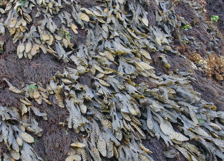
2                                        Neto A et al

Abstract

Background

The macroalgal flora of the Island of São Miguel (eastern group of the Azores Archipelago)
has attracted the interest of many researchers in the past, the first publications going back
to the nineteenth century. Initial studies were mainly taxonomic, resulting in the publication
of a checklist of the Azorean benthic marine algae. Later, the establishment of the
University of the Azores on the Island permitted the logistic conditions to develop both
temporal studies and long-term research and this resulted in a significant increase on
research directed at the benthic marine algae and littoral communities of the Island and
consequent publications.

Prior to the present paper, the known macroalgal flora of São Miguel Island comprised
around 260 species. Despite this richness, a significant amount of the research was never
made public, notably Masters and PhD theses encompassing information regarding
presence data recorded at littoral and sublittoral levels down to a depth of approximately
40 m around the Island and the many collections made, which resulted in vouchers
deposited in the AZB Herbarium Ruy Telles Palhinha and the LSM- Molecular Systematics
Laboratory at the Faculty of Sciences and Technology of the University of the Azores.

The present publication lists the macroalgal taxonomic records, together with information
on their ecology and occurrence around São Miguel Island, improving the knowledge of the
Azorean macroalgal flora at local and regional scales.

New information

A total of 12,781 specimens (including some identified only to genus) belonging to 431 taxa
of macroalgae are registered, comprising 284 Rhodophyta, 59 Chlorophyta and 88
Ochrophyta (Phaeophyceae). Of these, 323 were identified to species level (212
Rhodophyta, 48 Chlorophyta and 63 Ochrophyta), of which 61 are new records for the
Island (42 Rhodophyta, 9 Chlorophyta and 10 Ochrophyta), one an Azorean endemic
(Predaea feldmannii subsp. azorica Gabriel), five are Macaronesian endemisms (the red
algae Botryocladia macaronesica Afonso-Carrillo, Sobrino, Tittley & Neto, Laurencia viridis
Gil-Rodríguez & Haroun, Millerella tinerfensis (Seoane-Camba) S.M.Boo & J.M.Rico,
Phyllophora gelidioides P.Crouan & H.Crouan ex Karsakoff and the green alga Codium
elisabethiae O.C.Schmidt), 19 are introduced species (15 Rhodophyta, two Chlorophyta
and two Ochrophyta) and 32 are of uncertain status (21 Rhodophyta, five Chlorophyta and
six Ochrophyta).

Keywords
macroalgae, Azores, São Miguel Island, new records, endemism, native, uncertain,
introduced, occurrence data, ecology
Marine algal flora of São Miguel Island, Azores                     3

Introduction
Research on the marine algae from the Azores started in the mid-nineteenth century
(1838) when Guthnick and the two Hochstetters, father and son, visited the Archipelago
(Neto 1994). Since then, many other researchers and naturalists have visited the
Archipelago, resulting in several publications on the marine algal flora of this region (see
summary in Neto 1994, Neto 1997). Most initial studies were taxonomic, focusing on the
production of species lists. Almost a century later, the German botanist Otto Christian
Schmidt visited several islands, including São Miguel and initiated a more comprehensive
ecological approach describing species associations and their spatial organisation
(Schmidt 1931). Ever since the first half of the last century, several studies have focused
more widely on intertidal and shallow subtidal communities providing information on the
vertical distribution of macroalgae and invertebrates and their trophic relations (see Neto
1992, Neto 2000, Neto 2001 for a review on this subject). Taxonomic investigations have
continued and the first checklist of the Azorean benthic marine algae published by Neto
(1994) brought together the existing published information, provided distributional records
within the Archipelago and reported 307 species, indicating a moderately rich flora given its
isolated mid-Atlantic position. A revision of this first checklist was made by Parente (2010),
increasing the number of algae species to 327, but without providing their distributional
information on the Archipelago. Later, Rosas-Alquicira et al. (2011) published a catalogue
of non-fossil geniculate coralline red algae (Corallinales, Rhodophyta) of the Macaronesia,
in which they made both a critical review of species and infraspecific taxa, as well as an
assessment of species diversity in the region. Research by local teams was also dedicated
to the Azorean littoral communities and biota conservation (see, for example, Abecasis et
al. 2015, Amorim et al. 2015, Chainho et al. 2015). Taxonomic, ecological and
biotechnological investigations have continued generating knowledge on the Azorean
macroalgae flora, its biotechnological potential and also on the structure and functioning of
littoral communities (see revisions on Neto et al. 2014, Haroun et al. 2019 and Haroun et
al. 2019). Recently, several additional studies have been published with important
information on the Azorean algae biodiversity, biogeography, conservation, ecology and
taxonomy (see, for example, Bruno de Sousa et al. 2019, Cacabelos et al. 2019,
Cacabelos et al. 2020, Freitas et al. 2019, Kellaris et al. 2019, Martins et al. 2019, Parente
et al. 2019, Parente et al. 2020, Patarra et al. 2017, Patarra et al. 2019, Patarra et al. 2020,
Sousa et al. 2019, Faria et al. 2020a, Faria et al. 2020b, Vieira et al. 2020).

The paper by Freitas et al. (2019) increased the number of macroalgae species occurring
in the Azores to 405 and reported that, amongst the mid-Atlantic archipelagos, the Azores
is second in species richness after the Canary Islands, with 689 species, followed by
Madeira (396), Cabo Verde (333) and Selvagens (295 species). For some species, the
Azores Archipelago forms a boundary in their distribution. Codium effusum (Rafinesque)
Delle Chiaje, for example, is as its western distribution limit in the Archipelago (Leon-
Cisneros et al. 2012), whereas for Dudresnaya crassa M.Howe, a western Atlantic warm-
water species, the Azores extends its known distributional range to the east. Some
northern species such as the red alga Schizymenia dubyi (Chauvin ex Duby) J.Agardh and
Lomentaria orcadensis (Harvey) Collins come close to their southern limit of distribution in
4                                         Neto A et al

the Azores, while some southern warm-water species, such as green alga Anadyomene
stellata (Wulfen) C.Agardh and the red alga Sebdenia rodrigueziana (Feldmann) Codomier
ex Athanasiadis, reach their Atlantic northern limit of distribution on the Islands (Neto et al.
2005, Leon-Cisneros et al. 2012). Some species, relatively common in the region a few
years ago, have become uncommon or even very rare, for example, Scytosiphon
lomentaria (Lyngbye) Link, Schimmelmannia schousboei (J.Agardh) J.Agardh. In contrast,
there has been an increase in unexpected macroalgae in the Azores, with the arrival and
establishment of several non-native species (see Cardigos et al. 2006, Micael et al. 2014,
Vaz-Pinto et al. 2014, Parente et al. 2019, Cacabelos et al. 2019, Cacabelos et al. 2020,
Martins et al. 2019).

Within the spread of the Archipelago, there are no marked differences between floras of
individual Islands or Island groups and, biogeographically, the Azores algal flora reveals
itself to have a mixed nature, with species shared with Macaronesia, North Africa, the
Mediterranean Sea, Atlantic Europe and America (Tittley and Neto 1995, Tittley and Neto
2005, Tittley and Neto 2006, Tittley 2003, Wallenstein et al. 2009b). This nature of the
Azorean marine algal flora was reinforced by the work of Freitas et al. (2019), who, using
an extensive analysis encompassing data on coastal fishes, brachyurans, polychaetes,
gastropods echinoderms and macroalgae, suggested that the Azores should be a
biogeographical entity on its own and proposed a re-definition of the Lusitanian
biogeographical province, in which they included four ecoregions: the South European
Atlantic Shelf, the Saharan Upwelling area, the Azores ecoregion and a new ecoregion
they named Webbnesia, which comprises the archipelagos of Madeira, Selvagens and the
Canary Islands.

Not all the Azorean Islands have received the same attention regarding the studies on
macroalgae. Furthermore, many species may have been overlooked due to their small
size, opportunistic nature or ephemeral life span.

To overcome this and gain a better and up-to-date knowledge of the Archipelago’s
macroalgae flora, an effort was made by resident teams to undertake a considerable
amount of research over the past three decades on several Islands. The present paper is
the last one of a series and presents physical, occurrence data and information gathered
from macroalgal surveys undertaken on São Miguel Island between 1989 and 2019 mainly
by the Island Aquatic Research Group of the Azorean Biodiversity Centre of the University
of the Azores (Link: https://ce3c.ciencias.ulisboa.pt/sub-team/island-aquatic-ecology), the
BIOISLE, Biodiversity and Islands Research Group of CIBIO-Açores at the University of
the Azores (Link: https://cibio.up.pt/research-groups-1/details/bioisle) and the OKEANOS
Centre of the University of the Azores (Link: http://www.okeanos.uac.pt). In these surveys,
particular attention was given to the small filamentous and thin sheet-like forms that are
often short-lived and fast-growing and usually very difficult to identify in the field, without
the aid of a microscope and specialised literature in the laboratory.

This paper aims to provide a valuable marine biological tool to aid research on the
systematics, diversity and conservation, biological monitoring, climate change, ecology and
more applied studies, such as biotechnological applications, which will be of assistance to
Marine algal flora of São Miguel Island, Azores                   5

a wide range of focal groups including academics, students, governments, private
organisations and the general public.

General description
Purpose: This paper presents taxonomic records of macroalgae for São Miguel Island and
provides general information on their occurrence and distribution. By doing this, it will
contribute to address several biodiversity shortfalls (see Cardoso et al. 2011, Hortal et al.
2015), namely the need to catalogue the Azorean macroalgae (Linnean shortfall) to
improve current information on their local and regional geographic distribution (Wallacean
shortfall), as well as to provide a better understanding of species abundance and dynamics
in space (Prestonian shortfall).

Project description
Title: Marine algal flora of São Miguel Island, Azores

Personnel: Collections were conducted and occurrence data recorded over several years
(1989 - 2019). The main collectors were Adriá Pajares, Afonso C. L. Prestes, Alexandra
Pacheco, Amine Sebti, Ana Bettencourt, Ana Carreiro, Ana Cristina Costa, Ana F. Ferreira,
Ana Filipa Sousa, Ana I. Neto, Ana Leonado, Ana Rita Carreiro, Ana Rodriguez, André
Amaral, André Gillon, Andrea Salamanca, Andrea Z. Botelho, Andreia Levi, Andreia
Tracana, Anna Lloveras, Antalova Janouchová, Artur Oliveira, Brigida Garcia, Bruno
Magalhães, Bruno Sérgio, Camille Fontaine, Carlos Campos, Carlos Mir, Carlos Rius,
Carolina Moreira, Catarina Santos, Célia Albuquerque, Clara Gaspar, Cláudia Hipólito,
Cristiana Figueredo, Cristina Seijo, Dálida Pereira, Daniel Torrão, Daniela Gabriel, David
Milla-Figueras, Délia Cravo, Dinis Geraldes, Dolores Campos, Edgar F. Rosas-Alquicira,
Emanuel Xavier, Enric Ballesteros, Eunice Nogueira, Eva Cacabelos, Fernando Feiteira,
Filipe Parreira, Flávio Rodrigues, Francisco Wallenstein, Gloria Cantos, Gustavo Martins,
Heather Baldwin, Helena Abreu, Hélio Dias, Hugo Lopes, Ian Tittley, Ignacio Moreu,
Isadora Moniz, Joana Duarte, Joana Matzen, Jana Verdura, Joana Michael, João Brum,
João Faria, João Feijó, José M. N. Azevedo, José Medeiros, Juan Garcia Marino, Juan
Izaguirre, Juliana Dal Molin, Juliane Bernardi, Karla León-Cisneros, Laura Rovira, M.
Canto, Marco Enoch, Margarida Leonardo, Manuela I. Parente, Marc Balcells, Marc
Fernandez, Marco Henrique, Marco Santos, Maria Ana Dionísio, Maria Inês Pavão, Maria
Machín-Sánchez, Maria Vale, Mariano Rego, Marisa Toste, Marlene Terra, Marta Coca,
Miguel Frada, Mikel Mendizabal, Miguel Furtado, Miguel Matias, Miriam Gutierrez, Mutue
Toyota Fujii, Natália Jardim, Nikola Zic, Nil Alvarez Segura, Nuno Vaz Álvaro, Núria Vila, O.
Laclaustra, Olaia Morán, Olalla Torrontegi, Olivie Laroche, Patrícia Madeira, Patrícia
Pereira, Paula Avelar, Paulo Azevedo, Paulo Custódio, Paulo Torres, Pedro Cavazin,
Pedro Cerqueira, Pedro Raposeiro, Pedro Rodrigues, Rafael Fraga, Raquel Torres,
Renato Calado, Ricardo Lacerda, Rita F. Patarra, Rita Grilo, Rita Norberto, Robert
Fletcher, Rocio Sanchez, Roger Fuste, Ruben Couto, Rui Costa, Rui Jesus, Rui Moreira,
Rui Patrício, Rui Sousa, Sabrina Garcia, Sandra Monteiro, Sara Peres, Sérgio Ávila, Silvia
6                                               Neto A et al

Escarduça, Sofia Carreiro, Susan Clayden, Tarso Costa, Valeria Cassano and William
Farnham.

Preliminary in situ identifications were undertaken by: Ana I Neto, Andrea Z. Botelho,
Andreia Levi, Daniela Gabriel, David Milla-Figueras, Edgar F. Rosas-Alquicira, Enric
Ballesteros, Eva Cacabelos, Francisco Wallenstein, Heather Baldwin, Ian Tittley, Ignacio
Moreu, Karla León-Cisneros, Manuela I. Parente, Maria Machín-Sanchez, Marlene Terra,
Mutue Toyota Fujii, Nuno Vaz Álvaro, Raquel Torres, Robert Fletcher, Ruben Couto, Valeria
Cassano and William Farnham.

Final species identification were undertaken by Ana I. Neto, Daniela Gabriel, Edgar F.
Rosas-Alquicira, Enric Ballesteros, Eva Cacabelos, Ian Tittley, Ignacio Moreu, Karla León-
Cisneros, Manuela I. Parente, Maria Machín-Sanchez, Marlene Terra, Mutue Toyota Fujii,
Robert Fletcher, Valeria Cassano and William Farnham.

Voucher specimen management was mainly undertaken by Afonso C.L. Prestes, Ana I.
Neto, Eunice Nogueira, Manuela I. Parente, Natália Cabral, Rita Patarra and Roberto
Resendes.

Study area description: The Azores Archipelago (38°43′49″N, 27°19′10″W, Fig. 1),
isolated in the mid-Atlantic Ocean, comprises nine volcanic Islands and several islets
spread over 500 km in a WNW–ESE direction, emerging from the Azores Plateau and
located above an active triple junction between three of the world's largest tectonic plates
(the North American Plate, the Eurasian Plate and the African Plate, Hildenbrand et al.
2014).

    Figure 1.
    The Azores, its location in the Atlantic and São Miguel Island highlighted in black (by Nuno V.
    Álvaro).

The Archipelago comprises nine volcanic Islands and several small Islets in three separate
groups (eastern, central and western).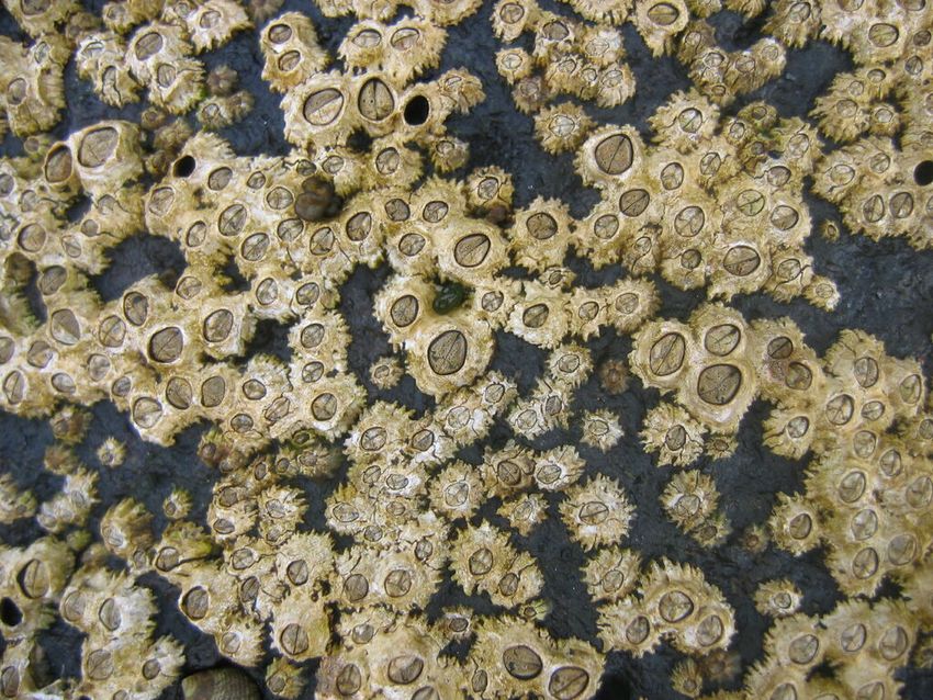
Marine algal flora of São Miguel Island, Azores                7

São Miguel (in black in Fig. 1), approximately 750 km² in size, is the largest and most
volcanically-active Island (Gaspar et al. 2015). Located in the eastern group of the
Archipelago (37°54'58''N, -25°51'52''W, Fig. 2), its formation followed a series of volcanic
events, with different parts of the Island having different ages. The oldest portion (4 M
years old) is the eastern side, Nordeste, where Pico da Vara (the highest mountain of the
Island with 1103 m a.s.l.) is located. The Island was then progressively formed to the west:
Povoação (2 M years); Furnas (750,000 years); Serra de Água de Pau (250,000 years).
The Sete Cidades complex appeared 500,000 years ago and only later (50,000 years ago)
was connected to Serra de Agua de Pau through the Serra Gorda and its succeeding line
of peaks (Zbyszewski et al. 1958, Zbyszewski and Ferreira 1959).

 Figure 2.
 São Miguel Island with indication of the sampling locations (by Nuno V. Álvaro).

As in the other Azorean Islands, the climate is considerably influenced by the surrounding
ocean and is characterised by regular rainfall, medium levels of relative humidity and
persistent winds, mainly during the winter and autumn seasons (Morton et al. 1998). The
tidal range is small (< 2 m) and the coastal extension is restricted, with deep waters
occurring within a few kilometres offshore (Hidrográfico 1981). Most sea-shores are subject
to swell and surge most of the year and few are sheltered, except for some bays and
harbours. Extremely heavy seas occur during winter (Neto et al. 2005).

São Miguel has the longest coastline in the archipelago, about 155 km, corresponding to
25.3% of the whole Azorean coastline. The coastal topology, resulting from the effect of the
maritime agitation, responsible for the predominance of erosive morphologies, is mainly
composed of high, steep cliffs with a variety of stack, arch and gully formations and is
mostly difficult to access by land. Most of the cliffs and coastal slopes are less than 50 m
a.s.l. (Borges 2003) and fall directly into the sea. The coastline is mainly composed of
irregular compact, bedrock platforms, alternating with boulder and cobble locations. On
some shores, boulders entrap coarse sand and gravel and there are a few sandy beaches
(Wallenstein et al. 2009b).
8 Neto A et al
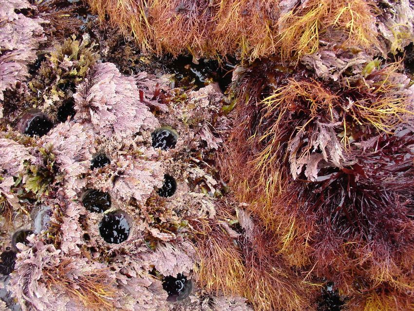
Intertidal communities of São Miguel Island, as on the other islands of the Archipelago, are
primarily dominated by macroalgae, which mainly exhibit a mosaic and/or zoned
distribution pattern and have a predominance of algal turfs that cover the rocks as a carpet
(Wallenstein et al. 2009), best seen when rocks are uncovered at low tide. There is a very
distinct horizontal pattern of species distribution, with three major zones commonly found
on bedrock and boulder shores (Neto 2000, Neto et al. 2005, Wallenstein et al. 2009b).
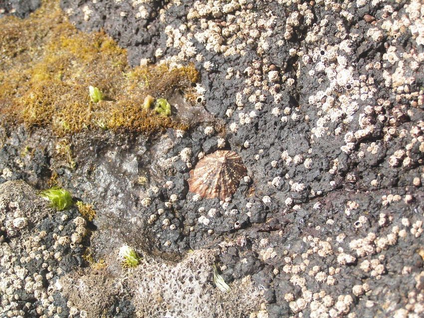
The uppermost intertidal level is dominated by littorinids (Fig. 3), while the mid-level zone is
usually characterised by a fringe of chthamalid barnacles (Fig. 4), in which sometimes
algae and limpets can occur (Fig. 5), followed by a lower area, in which either algal turf
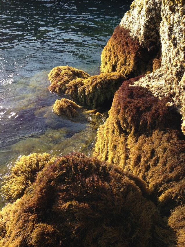
(generally monospecific and usually composed of Caulacanthus ustulatus (Turner)
Kützing) dominates (Fig. 6) or patches of the brown alga Fucus spiralis Linnaeus and the
red agarophyte Gelidium microdon Kützing (Fig. 7) grow interspaced with barnacles and
algal turf. The lowest intertidal zone, representing the transition to the sublittoral
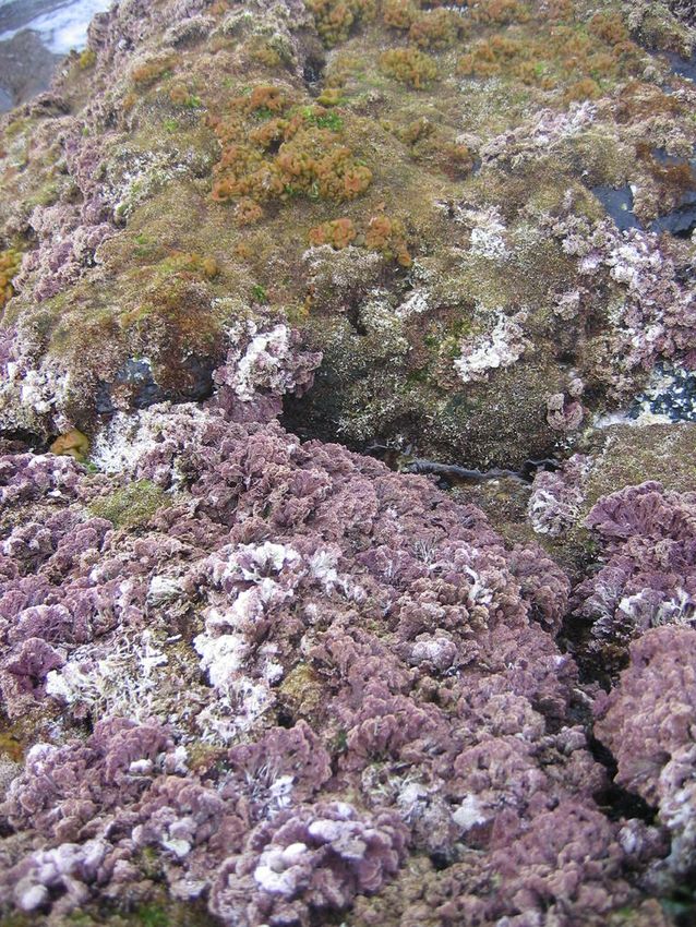
envrironment, is either dominated by algal turf (generally multispecific and commonly
dominated by coralline algae, Fig. 8) or by various species of frondose algae growing in
bands (e.g. the brown alga Gongolaria abies-marina (S.G.Gmelin) Kuntze, Fig. 9) or
forming patches amongst and over turf species (e.g. the agarophyte Pterocladiella
capillacea (S.G.Gmelin) Santelices & Hommersand and the calcareous Ellisolandia
elongata (J.Ellis & Solander) K.R.Hind & G.W.Saunders, Fig. 10). The brown alga
Colpomenia sinuosa (Mertens ex Roth) Derbès & Solier is very common at this level,
growing epiphytically on several other algae. Seasonally, the red algae Porphyra/
Neopyropia and/or Nemalion elminthoides (Velley) Batters can be seen growing in patches
at the mid-intertidal level. In some locations, the brown crust Nemoderma tingitanum
Schousboe ex Bornet can be common at this shore level (Neto et al. 2005, Wallenstein et
al. 2009b).
Figure 3.
Littorinids, a characteristic gastropod species of the Azorean high intertidal level (by the Island
Aquatic Ecology Subgroup of cE3c-ABG).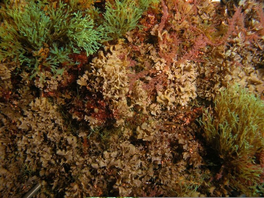
Marine algal flora of São Miguel Island, Azores                       9

 Figure 4.
 Chthamalid barnacles on São Miguel mid-intertidal level (by the Island Aquatic Ecology
 Subgroup of cE3c-ABG).

 Figure 5.
 Chthamalid barnacles, algal turf and limpet on São Miguel mid-intertidal level (by the Island
 Aquatic Ecology Subgroup of cE3c-ABG).

In spring and summer, considerable amounts of the introduced red alga Asparagopsis
armata Harvey can be seen at the lower intertidal level, normally as an epiphyte on other
algae (Neto, personal observation).

At cobble locations, the zonation pattern of macroalgae species is not clear (Costa 1994).
The many microhabitats and substrate instability tend to mask and attenuate the limits of
the biological zones. Nevertheless, in locations where cobbles are large and their size
enlarges towards the sea (e.g. Fenais da Luz, north shore), the profile is steeper and
usually the mid-intertidal level is dominated by the green macroalgae Ulva linza Linnaeus,
10                                        Neto A et al

U. clathrata (Roth) C.Agardh and U. rigida C.Agardh; the lower level is characterised by
the presence of algal turf, mainly composed of Jania crassa J. V. Lamouroux and Corallina
officinalis Linnaeus, with epiphytic Rhodophyta, such as Asparagopsis armata Harvey,
phase Falkenbergia rufolanosa (Harvey) F.Schmitz, Centroceras clavulatum (C.Agardh)
Montagne, Ceramium ciliatum (J.Ellis) Ducluzeau, C. deslongchampsii Chauvin ex Duby
and Polysiphonia atlantica Kapraun & J.N.Norris. In locations with small cobbles (e.g.
Caloura, south coast) or where there is a mixture of large and small cobbles (e.g.
Povoação, south coast), the mid-intertidal level is usually characterised by fast growing
algae, such as Cyanobacteria and the green algae Ulva spp., whereas the lowest level is
also dominated by algal turf, but here mainly composed of C. officinalis and C. clavulatum
(Caloura) or by C. clavulatum, Chondracanthus acicularis (Roth) Fredericq, Jania sp. and
Lophosiphonia sp. (Povoação).

 Figure 6.
 Algal turf, dominated by the red alga Caulacanthus ustulatus, on São Miguel mid-intertidal
 level (by the Island Aquatic Ecology Subgroup of cE3c-ABG).

 Figure 7.
 The brown alga Fucus spiralis and the red agarophyte Gelidium microdon on São Miguel mid-
 intertidal level (by the Island Aquatic Ecology Subgroup of cE3c-ABG).
Marine algal flora of São Miguel Island, Azores                      11

Figure 8.
Multispecific algal turf and the coralline red alga Ellisolandia elongata on São Miguel low
intertidal level (by the Island Aquatic Ecology Subgroup of cE3c-ABG).

Figure 9.
The brown alga Gongolaria abies-marina growing in bands at the low shore level (by the
Island Aquatic Ecology Subgroup of cE3c-ABG).
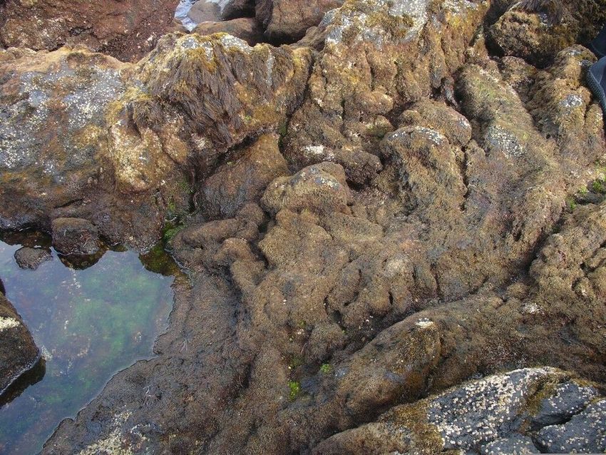
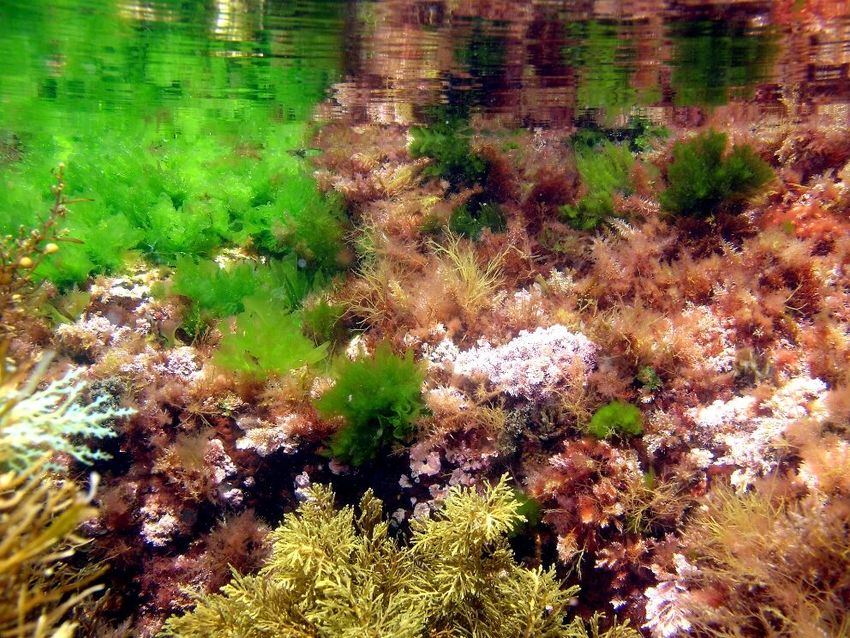
12                                         Neto A et al

Important habitats at the shore level in bedrock locations are rock pools (Fig. 11). Differing
in shape and size, they recreate a shallow subtidal habitat which may contain a rich
diversity of marine algae and other marine organisms (Neto et al. 2005, Wallenstein et al.
2010).

 Figure 10.
 Patches of the agarophyte Pterocladiella capillacea and the calcareous Ellisolandia elongata
 at the low intertidal level (by the Island Aquatic Ecology Subgroup of cE3c-ABG).

 Figure 11.
 Low shore pool (by the Island Aquatic Ecology Subgroup of cE3c-ABG).

The macroalgae diversity varies according to the pool location on the shore. Pools in the
upper shore region are dominated by green algae, whilst those lower on the shore are
dominated by red and brown algae. Similarly, faunal diversity in rock pools is greater at
lower intertidal levels.

The adjacent submerged zone is also dominated by algal vegetation, with the rocky
bottoms covered by more frondose macrophytes (Neto 2001, Wallenstein et al. 2009b),
such as the red algae Asparagopsis taxiformis (Delile) Trevisan, Ellisolandia elongata,
Marine algal flora of São Miguel Island, Azores                       13

Jania spp., Plocamium cartilagineum (Linnaeus) P.S.Dixon, Pterocladiella capillacea and
Sphaerococcus coronopifolius Stackhouse and the brown algae Dictyopteris polypodioides
(A.P.De Candolle) J.V.Lamouroux, Dictyota spp., Gongolaria abies marina (S.G.Gmelin)
Kuntze, Halopteris scoparia (Linnaeus) Sauvageau and                  Zonaria tournefortii
(J.V.Lamouroux) Montagne (Fig. 12). The introduced red alga, Symphyocladia
marchantioides (Harvey) Falkenberg, can be locally abundant below 15 m depth, usually
as an ephiphyte on calcareous crusts; Hypnea musciformis (Wulfen) J.V.Lamouroux and
Dasya spp. are other red algal species that can be locally abundant. The green species
Codium elisabethiae (Fig. 13) and the brown species Padina pavonica (Linnaeus) Thivy
can also be locally common, mainly in locations with sand influence (Neto 2001).

 Figure 12.
 The frondose brown algae Zonaria tournefortii and Dictyota spp. at the deepest level sampled
 (by the Island Aquatic Ecology Subgroup of cE3c-ABG).

 Figure 13.
 The Macaronesian endemic Codium elisabethiae on the shallow bottoms of São Miguel Island
 (by the Island Aquatic Ecology Subgroup of cE3c-ABG).
14                                     Neto A et al

Design description: The sampling referred to in this study was performed across littoral
and sublittoral levels down to approximately 40 m. Each sampling location was visited
several times and, on each occasion, a careful and extensive survey was undertaken to
provide a good coverage of the area. Both presence recording and physical collections
were made by walking over the intertidal shores during low tides or by SCUBA diving in the
subtidal. The specimens collected were taken to the laboratory for identification and
preservation and the resulting vouchers were deposited at the AZB Herbarium Ruy Telles
Palhinha and the LSM - Molecular Systematics Laboratory at the Faculty of Sciences and
Technology of the University of the Azores.

Funding: This study was mainly financially supported by the following projects/scientific
expeditions:

 •     Projects:
        ◦     ABLA/MAC – “Associações Biológicas do Litoral Açoreano/Moluscos, Algas
              e Crustáceos”, funded by the Portuguese Science and Technology
              Foundation (1987-1991);
        ◦     Azorean Algal Flora – “Studies on algal communities of São Miguel,
              Azores”, partially funded by CIRN/DB/UAc (1992-1996);
        ◦     BIA - “Biodiversity of Azores Archipelago”, funded by the Portuguese
              Science     and      Technology   Foundation.   PRAXIS/2/2.1/BIA/169/94
              (1996-1999);
        ◦     BIOTOPE – “ Classification, mapping and modelling of Azorean littoral
              biotopes”, funded by the Portuguese Science and Technology Foundation,
              POCTI MGS/45319/2002 (2003-2006);
        ◦     CAMAG/ORI – “Characterization of coastal water bodies on the islands of
              Santa Maria and São Miguel”, funded by the Regional Government of the
              Azores, Regional Secretariat for the Environment and the Sea, Regional
              Directorate for Planning and Water Resources (2008-2012);
        ◦     GESMAR – “ Sustainable management of marine Resources”, funded by
              the EU Funding Programme III B 2000-2006, Açores-Madeira-Canárias,
              GESMAR/MAC/2/C068 (2009-2012);
        ◦     PATELGENE – “ Genetic Structure of Azorean Limpets: Implications for
              Conservation and Marine Protected Areas”, funded by the Portuguese
              Science and Technology Foundation, PTDC/BIA-BIC/115837/2009
              (2011-2014);
        ◦     MACROBIOMOL – “Macroalgae biodiversity under a molecular view - for a
              better understanding of North Atlantic Biogeography”, funded by PTDC/
              MAR/114613/2009 (2011-2015);
        ◦     ASMAS – “Açores: Stop-over for Marine Alien Species?”, funded by the
              Government of the Azores - Regional Secretariat for the Sea, Science and
              Technology, M2.1.2/I/032/2011 (2012-2016);
        ◦     BUS – “ Urban Structures: a driver of biodiversity change in coastal
              ecosystems?”, funded by the Portuguese Science and Technology
              Foundation, PTDC/MAR-EST/2160/2012 (2013-2015);
Marine algal flora of São Miguel Island, Azores 15
◦ ECOSUBVEG – “ Changes in submersed vegetation: assessing loss in
ecosystems services from frondose to depauperate systems dominated by
opportunistic vegetation”, funded by the Voluntary Scheme for Biodiversity
and Ecosystem Services in Territories of the EU Outermost Regions and
Oversees Countries and Territories, BEST 07.032700/2012/635752/SUB/B2
(2013-2016);
◦ LAUMACAT - “ Diversity and phylogenetic relationships on the benthic
marine algae with pharmacological potential: the Laurencia complex
(Rhodophyta) in Macaronesian archipelagos, tropical and subtropical
Atlantic”, funded by the Ministerio de Ciencia e Innovación, Dirección
General de Investigación y Gestión del Plan Nacional de R+D+i,
Subdirección General de Proyectos de Investigación, Gobierno de España
(2010-2013) and by the São Paulo State Research Support Foundation
(FAPESP), Brazil, Proc. 2014 / 00012-1 (2013 a 2016);
◦ BALA – “Elaboration of the implementation program of the marine strategy
framework directive - biodiversity of the coastal environments of the Azores”
(2 /DRAM /2015), funded by the Government of the Azores - Regional
Secretariat for the Sea, Science and Technology, Regional Directorate for
Sea Affairs, GRA /SRMCT-DRAM, (2015);
◦ PIMA – “Elaboration of the implementation program of the Marine Strategy
Framework Directive - Marine Invasion Program in the Azores” (3/DRAM /
2015), funded by the Government of the Azores - Regional Secretariat for
the Sea, Science and Technology, Regional Directorate for Sea Affairs,
GRA /SRMCT-DRAM, (2015);
◦ ASPAZOR – “Ecosystem impacts and socioeconomic benefits of
Asparagopsis armata in the Azores”, funded by the Regional Direction for
Science, Technology. ACORES-01 -0145-FEDER-000060 (2016-2020);
◦ PORBIOTA - “ACORES-01-0145-FEDER-000072 - AZORES BIOPORTAL”,
funded by the Operational Programme Azores 2020 (85% ERDF and 15%
regional funds) (2019-2021);
• Scientific Expeditions and campaigns:
◦ “Campaign Macaronesia 2000”, under the project Macaronesia 2000
(2000-2001);
◦ “Waitt Foundation”, under the projects BALA and PIMA (2016);
◦ “BALA/PIMA”, under the projects BALA and PIMA (2018);
◦ “PORBIOTA/2019” under the project ACORES-01-0145-FEDER-000072 -
AZORES BIOPORTAL – PORBIOTA (2019);
• Other funds:
◦ Portuguese National Funds, through FCT – the Portuguese Science and
Technology Foundation, within the projects UID/BIA/00329/2013,
2015-2019, UID/BIA/00329/2020-2023 and UID/BIA/50027/2019, UID/BIA/
50027/2013-2020, UID/Multi/04423/2013, PEst-C/MAR/LA0015/2013 and
POCI-01-0145-FEDER-006821;
◦ European Regional Development (ERD) funds through the Operational
Programme for Competitiveness Factors (COMPETE);16 Neto A et al
◦ Portuguese Regional Funds, through DRCT - Regional Directorate for
Science and Technology, within several projects, 2019 and 2020 and
SRMCT /DRAM - Regional Secretariat for the Sea, Science and
Technology, Regional Directorate for Sea Affairs;
◦ CIRN/DB/UAc (Research Centre for Natural Resources, Universidade dos
Açores, Departamento de Biologia);
◦ CIIMAR (Interdisciplinary Centre of Marine and Environmental Research,
Porto, Portugal).
Sampling methods
Study extent: The present publication includes sampling performed over a relatively large
area, covering littoral and sublittoral levels down to approximately 40 m around the Island
(Table 1, Fig. 2).
Table 1.
Information and location of the sampling sites on São Miguel Island
Location Location ID Municipality Locality Latitude / Littoral
N0 Longitude zone
1 SMG_L_APs Lagoa Água de Pau | Subtidal 37°43'08''N, Subtidal
25°27'45''W
2 SMG_L_APsE Lagoa Água de Pau | Subtidal E 37°43'10''N, Subtidal
25°27'44''W
3 SMG_L_APsW Lagoa Água de Pau | Subtidal W 37°43'27''N, Subtidal
25°27'16''W
4 SMG_L_Avb Lagoa Atalhada | Viteleiro | baía 37°44'38''N, Subtidal
25°23'23''W
5 SMG_L_Avem Lagoa Atalhada | Viteleiro | Entre-marés 37°44'43''N, Intertidal
25°23'24''W
6 SMG_L_Cbab Lagoa Caloura | Baixa da Areia | baía 37°42'50''N, Subtidal
25°28'11''W
7 SMG_L_Ccb Lagoa Caloura | Cerco | baía 37°42'24''N, Subtidal
25°29'30''W
8 SMG_L_CcbW Lagoa Caloura | Cerco | baía W 37°42'21''N, Subtidal
25°29'07''W
9 SMG_L_Ccem Lagoa Caloura | Cerco | Entre-marés 37°42'27''N, Intertidal
25°29'27''WMarine algal flora of São Miguel Island, Azores 17
Location Location ID Municipality Locality Latitude / Littoral
N0 Longitude zone
10 SMG_L_Cepgb Lagoa Caloura | Entre Porto e Galera | 37°42'24''N, Subtidal
baía 25°29'52''W
11 SMG_L_Cgb Lagoa Caloura | Galera | baía 37°42'10''N, Subtidal
25°29'27''W
12 SMG_L_Chem Lagoa Caloura | Hotel | Entre-marés 37°42'50''N, Intertidal
25°28'59''W
13 SMG_L_Cpb Lagoa Caloura | porto | baía 37°42'45''N, Subtidal
25°30'15''W
14 SMG_L_Cpem Lagoa Caloura | porto | Entre-marés 37°42'47''N, Intertidal
25°30'15''W
15 SMA_L_Crcb Lagoa Caloura | Ribeira Chã | baía 37°42'45''N, Subtidal
25°30'16''W
16 SMG_L_Lbp Lagoa Lagoa | Bairro dos Pescadores 37°44'23''N, Subtidal
25°25'00''W
17 SMG_L_Lcrb Lagoa Lagoa | Cruzeiro | baía 37°44'34''N, Subtidal
25°25'56''W
18 SMG_L_Lcrem Lagoa Lagoa | Cruzeiro | Entre-marés 37°44'32''N, Intertidal
25°25'49''W
19 SMG_L_Lovem Lagoa Lagoa | Observatório 37°44'31''N, Intertidal
vulcanológico | Entre-marés 25°24'44''W
20 SMG_L_Lpib Lagoa Lagoa | Piscina | baía 37°44'26''N, Subtidal
25°25'33''W
21 SMG_L_Lpiem Lagoa Lagoa | Piscina | Entre-marés 37°44'29''N, Intertidal
25°25'34''W
22 SMG_L_Lpb Lagoa Lagoa | porto | baía 37°44'26''N, Subtidal
25°25'25''W
23 SMG_L_Pepem Lagoa Pisão | Entre praias | Entre- 37°43'02''N, Intertidal
marés 25°31'12''W
24 SMG_N_AN Nordeste Achada do Nordeste 37°51'34''N, Intertidal
25°43'23''W
25 SMG_N_LGpsem Nordeste Lombo Gordo | Ponta do 37°47'18''N, Intertidal
Sossego | Entre-marés 25°51'27''W
26 SMG_N_Nb6 Nordeste Nordeste | baía 6 37°50'21''N, Subtidal
25°52'15''W18 Neto A et al
Location Location ID Municipality Locality Latitude / Littoral
N0 Longitude zone
27 SMG_N_Nb7 Nordeste Nordeste | baía 7 37°48'55''N, Subtidal
25°53'22''W
28 SMG_N_Npinb Nordeste Nordeste | Piscinas Naturais | 37°50'39''N, Subtidal
baía 25°51'17''W
29 SMG_N_Npmb Nordeste Nordeste | Ponta da Madrugada | 37°49'30''N, Subtidal
baía 25°52'25''W
30 SMG_N_Npmqb Nordeste Nordeste | Ponta da Marquesa | 37°47'59''N, Subtidal
baía 25°51'35''W
31 SMG_N_Npaem Nordeste Nordeste | Ponta do Arnel | Entre- 37°49'21''N, Intertidal
marés 25°51'49''W
32 SMG_PD_Bab Ponta Bretanha | Ajuda | baía 37°54'02''N, Subtidal
Delgada 25°14'56''W
33 SMG_PD_Baem Ponta Bretanha | Ajuda | Entre-marés 37°54'00''N, Intertidal
Delgada 25°15'00''W
34 SMG_PD_Cb Ponta Candelária | baía 37°49'15''N, Subtidal
Delgada 25°10'04''W
35 SMG_PD_CPpb Ponta Capelas | porto | baía 37°50'32''N, Subtidal
Delgada 25°18'46''W
36 SMG_PD_FLem Ponta Fenais da Luz | Entre-marés 37°49'54''N, Intertidal
Delgada 25°22'23''W
37 SMG_PD_Fb Ponta Ferraria | baía 37°51'26''N, Subtidal
Delgada 25°08'51''W
38 SMG_PD_Fem Ponta Ferraria | Entre-marés 37°51'30''N, Intertidal
Delgada 25°08'50''W
39 SMG_PD_Ftb Ponta Feteiras | baía 37°46'57''N, Subtidal
Delgada 25°13'24''W
40 SMG_PD_Ftem Ponta Feteiras | Entre-marés 37°48'13''N, Intertidal
Delgada 25°11'47''W
41 SMG_PD_Ftpfgs Ponta Feteiras | Ponta da Fonte Grande 37°46'12''N, Subtidal
Delgada | Subtidal 25°13'48''W
42 SMG_PD_Ftpem Ponta Feteiras | Porto | Entre-marés 37°48'12''N, Intertidal
Delgada 25°11'49''W
43 SMG_PD_Mib Ponta Mosteiros | Ilhéus | baía 37°53'20''N, Subtidal
Delgada 25°10'00''WMarine algal flora of São Miguel Island, Azores 19
Location Location ID Municipality Locality Latitude / Littoral
N0 Longitude zone
44 SMG_PD_Mpinb Ponta Mosteiros | piscinas naturais | 37°54'02''N, Subtidal
Delgada baía 25°10'31''W
45 SMG_PD_Mpinemb Ponta Mosteiros | piscinas naturais | 37°53'56''N, Intertidal
Delgada Entre-marés | Blocos 25°10'58''W
46 SMG_PD_Mpinemc1 Ponta Mosteiros | piscinas naturais | 37°53'58''N, Intertidal
Delgada Entre-marés | Calhau 1 25°10'45''W
47 SMG_PD_Mpinemc2 Ponta Mosteiros | piscinas naturais | 37°53'57''N, Intertidal
Delgada Entre-marés | Calhau 2 25°10'56''W
48 SMG_PD_Mpineme1 Ponta Mosteiros | piscinas naturais | 37°54'01''N, Intertidal
Delgada Entre-marés | Escoada 1 25°10'50''W
49 SMG_PD_Mpineme2 Ponta Mosteiros | piscinas naturais | 37°53'59''N, Intertidal
Delgada Entre-marés | Escoada 2 25°10'44''W
50 SMG_PD_Mpineme3 Ponta Mosteiros | piscinas naturais | 37°53'59''N, Intertidal
Delgada Entre-marés | Escoada 3 25°10'46''W
51 SMG_PD_Mpineme4 Ponta Mosteiros | piscinas naturais | 37°54'02''N, Intertidal
Delgada Entre-marés | Escoada 4 25°10'54''W
52 SMG_PD_Mpinpo Ponta Mosteiros | piscinas naturais | 37°54'01''N, Intertidal
Delgada Poças 25°10'48''W
53 SMG_PD_Mpem Ponta Mosteiros | porto | Entre-marés 37°53'33''N, Intertidal
Delgada 25°10'42''W
54 SMG_PD_Mpremw Ponta Mosteiros | Praia | Entre-marés 37°53'20''N, Intertidal
Delgada (W) 25°10'27''W
55 SMG_PD_Pdcacb Ponta Ponta Delgada | Calheta | atrás 37°44'30''N, Subtidal
Delgada da cadeia | baía 25°20'46''W
56 SMG_PD_PDeb Ponta Ponta Delgada | Etar | baía 37°44'27''N, Subtidal
Delgada 25°21'02''W
57 SMG_PD_PDeem Ponta Ponta Delgada | Etar | Entre- 37°44'29''N, Intertidal
Delgada marés 25°21'02''W
58 SMG_PD_PDeem Ponta Ponta Delgada | Etar | Entre- 37°44'29''N, Subtidal
Delgada marés 25°21'02''W
59 SMG_PD_PDmle Ponta Ponta Delgada | marina | lado 37°44'22''N, Subtidal
Delgada externo 25°20'35''W
60 SMG_PD_Pdmleem Ponta Ponta Delgada | marina | lado 37°44'22''N, Intertidal
Delgada externo | Entre-marés 25°20'29''W20 Neto A et al
Location Location ID Municipality Locality Latitude / Littoral
N0 Longitude zone
61 SMG_PD_PDmli Ponta Ponta Delgada | marina | lado 37°44'26''N, Subtidal
Delgada interno 25°20'29''W
62 SMG_PD_PDmn Ponta Ponta Delgada | marina nova 37°44'20''N, Intertidal
Delgada 25°20'05''W
63 SMG_PD_PDmn Ponta Ponta Delgada | marina nova 37°44'20''N, Subtidal
Delgada 25°20'05''W
64 SMG_PD_PDpe Ponta Ponta Delgada | pesqueiro 37°44'21''N, Subtidal
Delgada 25°20'18''W
65 SMG_PD_PDple Ponta Ponta Delgada | porto | lado 37°44'06''N, Subtidal
Delgada externo 25°20'28''W
66 SMG_PD_PDpli Ponta Ponta Delgada | porto | lado 37°44'11''N, Subtidal
Delgada interno 25°20'32''W
67 SMG_PD_PDscb Ponta Ponta Delgada | Santa Clara | 37°43'53''N, Subtidal
Delgada baía 25°18'59''W
68 SMG_PD_PDscfem Ponta Ponta Delgada | Santa Clara | 37°43'58''N, Intertidal
Delgada Farol | Entre-marés 25°18'46''W
69 SMG_PD_PDscpoem Ponta Ponta Delgada | Santa Clara | 37°43'58''N, Intertidal
Delgada pontão | Entre-marés 25°18'45''W
70 SMG_PD_Popmem Ponta Pópulo | Praia das milícias | 37°44'58''N, Intertidal
Delgada Entre-marés 25°22'38''W
71 SMG_PD_Poppem Ponta Pópulo | Praia pequena | Entre- 37°44'56''N, Intertidal
Delgada marés 25°22'59''W
72 SMG_PD_Rb Ponta Relva | baía 37°45'57''N, Subtidal
Delgada 25°15'21''W
73 SMG_R_bes Ponta Relva | Baixa do Espelho | 37°45'41''N, Subtidal
Delgada Subtidal 25°15'29''W
74 SMG_PD_SAACem Ponta Santo António Além Capelas | 37°51'52''N, Intertidal
Delgada Entre-marés 25°18'00''W
75 SMG_PD_SRd Ponta São Roque | Dori 37°44'42''N, Subtidal
Delgada 25°22'22''W
76 SMG_PD_SRfcem Ponta São Roque | Forno da Cal | 37°44'39''N, Intertidal
Delgada Entre-marés 25°21'34''W
77 SMG_PD_SRpb Ponta São Roque | Pranchinha | baía 37°44'37''N, Subtidal
Delgada 25°21'08''WMarine algal flora of São Miguel Island, Azores 21
Location Location ID Municipality Locality Latitude / Littoral
N0 Longitude zone
78 SMG_PD_SRpem Ponta São Roque | Pranchinha | Entre- 37°44'38''N, Intertidal
Delgada marés 25°21'07''W
79 SMG_PD_SRrcb Ponta São Roque | Rosto do Cão | baía 37°44'36''N, Subtidal
Delgada 25°21'39''W
80 SMG_PD_SRrcem1 Ponta São Roque | Rosto do Cão | 37°44'40''N, Intertidal
Delgada Entre-marés 1 25°21'37''W
81 SMG_PD_SRrcem2 Ponta São Roque | Rosto do Cão | 37°44'38''N, Intertidal
Delgada Entre-marés 2 25°21'40''W
82 SMG_PD_SRrcem3 Ponta São Roque | Rosto do Cão | 37°44'40''N, Intertidal
Delgada Entre-marés 3 25°21'39''W
83 SMG_PD_SVpobe Ponta São Vicente | Poços | baía (E) 37°50'06''N, Subtidal
Delgada 25°20'04''W
84 SMG_PD_SVpobw Ponta São Vicente | Poços | baía (W) 37°50'04''N, Subtidal
Delgada 25°19'55''W
85 SMG_PD_SVpoeme Ponta São Vicente | Poços | Entre- 37°50'02''N, Intertidal
Delgada marés (E) 25°19'53''W
86 SMG_PD_SVpoemw Ponta São Vicente | Poços | Entre- 37°50'03''N, Intertidal
Delgada marés (W) 25°19'53''W
87 SMG_PD_SVpoi Ponta São Vicente | Poços | ilhéu 37°50'03''N, Subtidal
Delgada 25°20'02''W
88 SMG_P_bls Povoação Baixa da Lobeira | Subtidal 37°43'14''N, Subtidal
25°40'52''W
89 SMG_P_brqs Povoação Baixa da Ribeira Quente | 37°43'26''N, subtidal
Subtidal 25°41'22''W
90 SMG_P_FTem Povoação Faial da Terra | Entre-marés 37°44'20''N, Intertidal
25°48'12''W
91 SMG_P_RQbf Povoação Ribeira Quente | baía | 37°43'36''N, Subtidal
Fumarolas 25°41'22''W
92 SMG_P_RQbr Povoação Ribeira Quente | Baixa da Ribeira 37°43'59''N, Subtidal
25°42'16''W
93 SMG_P_RQborb Povoação Ribeira Quente | Boca da Ribeira 37°43'59''N, Subtidal
| baía 25°42'23''W
94 SMG_P_RQrcem Povoação Ribeira Quente | Rua do Castelo | 37°43'43''N, Intertidal
Entre-marés 25°41'32''W22 Neto A et al
Location Location ID Municipality Locality Latitude / Littoral
N0 Longitude zone
95 SMG_RG_apgrpcpm21s Ribeira Área Protegida de Gestão de 37°50'34''N, Subtidal
Grande Recursos da Ponta do Cintrão – 25°30'51''W
Ponta da Maia (SMG21) |
Subtidal
96 SMG_RG_FAem Ribeira Fenais da Ajuda | Entre-marés 37°51'56''N, Intertidal
Grande 25°41'01''W
97 SMG_RG_Mamem Ribeira Maia | Alameda do Mar | Entre- 37°50'03''N, Intertidal
Grande marés 25°36'17''W
98 SMG_RG_M_cms Ribeira Maia | Cabecinhos da Maia | 37°50'44''N, Subtidal
Grande Subtidal 25°36'00''W
99 SMG_RG_Mfmb Ribeira Maia | Frade da Maia | baía 37°50'17''N, Subtidal
Grande 25°36'07''W
100 SMG_RG_Mlmb Ribeira Maia | Lomba da Maia | baía 37°50'56''N, Subtidal
Grande 25°38'43''W
101 SMG_RG_Mpinpb Ribeira Maia | Piscinas naturais | pontas | 37°50'08''N, Subtidal
Grande baía 25°36'20''W
102 SMG_RG_Mpinpem Ribeira Maia | Piscinas naturais | pontas | 37°50'10''N, Intertidal
Grande Entre-marés 25°36'23''W
103 SMG_RG_Mpem Ribeira Maia | porto | Entre-marés 37°50'02''N, Intertidal
Grande 25°36'47''W
104 SMG_RG_PFbE Ribeira Porto Formoso | baía E 37°50'00''N, Subtidal
Grande 25°33'58''W
105 SMG_RG_PFpb Ribeira Porto Formoso | porto | baía 37°49'29''N, Subtidal
Grande 25°34'22''W
106 SMG_RG_PFpem Ribeira Porto Formoso | porto | Entre- 37°49'27''N, Intertidal
Grande marés 25°34'27''W
107 SMG_RG_Pfprem Ribeira Porto Formoso | praia | Entre- 37°49'25''N, Intertidal
Grande marés 25°33'25''W
108 SMG_RG_PFpmb Ribeira Porto Formoso | Praia dos 37°50'13''N, Subtidal
Grande moinhos | baía 25°33'05''W
109 SMG_RG_PFsbb Ribeira Porto Formoso | São Brás | baía 37°49'46''N, Subtidal
Grande 25°35'08''W
110 SMG_RG_Pfztem Ribeira Porto Formoso | Zona termal | 37°49'36''N, Intertidal
Grande Entre-marés 25°31'38''WMarine algal flora of São Miguel Island, Azores 23
Location Location ID Municipality Locality Latitude / Littoral
N0 Longitude zone
111 SMG_RG_RPcem Ribeira Rabo de Peixe | Calhetas | Entre- 37°49'28''N, Intertidal
Grande marés 25°23'42''W
112 SMG_RG_RGbem Ribeira Ribeira Grande | Bandejo | Entre- 37°49'17''N, Intertidal
Grande marés 25°27'51''W
113 SMG_RG_Rfpb Ribeira Ribeirinha | Furna da Pataca | 37°50'35''N, Subtidal
Grande baía 25°30'52''W
114 SMG_RG_Rpcb Ribeira Ribeirinha | Ponta do Cintrão | 37°50'11''N, Subtidal
Grande baía 25°31'20''W
115 SMG_RG_Rpsib Ribeira Ribeirinha | Porto de Santa Iria | 37°50'08''N, Subtidal
Grande baía 25°30'59''W
116 SMG_RG_RpsibW Ribeira Ribeirinha | Porto de Santa Iria | 37°50'34''N, Subtidal
Grande baía W 25°30'06''W
117 SMG_RG_Rpsiem Ribeira Ribeirinha | Porto de Santa Iria | 37°50'08''N, Intertidal
Grande Entre-marés 25°30'56''W
118 SMG_PD_SVpoemw Ribeira São Vicente | Poços | Entre- 37°50'03''N, Intertidal
Grande marés (W) 25°19'53''W
119 SMG_VF_AA_bgs Vila Franca Água de Alto | Baixa da Garoupa 37°42'31''N, Subtidal
do Campo | Subtidal 25°31'47''W
120 SMG_VF_AAbr Vila Franca Água de Alto | Boca da Ribeira 37°42'56''N, Intertidal
do Campo 25°32'48''W
121 SMA_VF_AAtm Vila Franca Água de Alto | Três Marias 37°42'29''N, Subtidal
do Campo 25°31'56''W
122 SMG_VF_PGb Vila Franca Ponta Garça | baía 37°42'56''N, Intertidal
do Campo 25°36'41''W
123 SMG_VF_PGb Vila Franca Ponta Garça | baía 37°42'56''N, Subtidal
do Campo 25°36'41''W
124 SMG_VF_PGbE Vila Franca Ponta Garça | baía E 37°42'46''N, Subtidal
do Campo 25°37'36''W
125 SMG_VF_PGem1 Vila Franca Ponta Garça | Entre-marés 1 37°42'58''N, Intertidal
do Campo 25°36'48''W
126 SMG_VF_PGem2 Vila Franca Ponta Garça | Entre-marés 2 37°42'59''N, Intertidal
do Campo 25°36'41''W
127 SMG_VF_RPem Vila Franca Ribeira da Praia | Entre-marés 37°42'54''N, Intertidal
do Campo 25°34'43''W24 Neto A et al
Location Location ID Municipality Locality Latitude / Littoral
N0 Longitude zone
128 SMG_VF_RTem Vila Franca Ribeira das Tainhas | Entre- 37°42'55''N, Intertidal
do Campo marés 25°35'52''W
129 SMG_VF_VFile Vila Franca Vila Franca do Campo | Ilhéu | 37°42'14''N, Subtidal
do Campo lado externo 25°33'27''W
130 SMG_VF_VFilep Vila Franca Vila Franca do Campo | Ilhéu | 37°42'00''N, Subtidal
do Campo lado externo | picos 25°33'22''W
131 SMG_VF_VFileE Vila Franca Vila Franca do Campo | Ilhéu | 37°42'18''N, Subtidal
do Campo lado externo E 25°33'32''W
132 SMG_VF_VFileS Vila Franca Vila Franca do Campo | Ilhéu | 37°42'14''N, Subtidal
do Campo lado externo S 25°33'20''W
133 SMG_VF_VFileSW Vila Franca Vila Franca do Campo | Ilhéu | 37°42'15''N, Subtidal
do Campo lado externo SW 25°33'19''W
134 SMG_VF_VFmem Vila Franca Vila Franca do Campo | marina | 37°42'54''N, Intertidal
do Campo Entre-marés 25°34'16''W
135 SMG_VF_VFmli Vila Franca Vila Franca do Campo | marina | 37°42'50''N, Subtidal
do Campo lado interno 25°34'12''W
136 SMG_VF_VFpbw Vila Franca Vila Franca do Campo | porto | 37°42'45''N, Subtidal
do Campo baía (W) 25°33'53''W
137 SMG_VF_VFpemw Vila Franca Vila Franca do Campo | porto | 37°42'50''N, Intertidal
do Campo Entre-marés (W) 25°33'58''W
138 SMG_VF_VFpem Vila Franca Vila Franca do Campo | praia | 37°42'59''N, Intertidal
do Campo Entre-marés 25°34'22''W
Sampling description: Sampling involved species presence recording and/or specimen
collecting at each sampling location. Species recording data were gathered by registering
all species present in the sampled locations (Fig. 14). Destructive samples were obtained
by scraping and/or manually collecting one or two specimens of every species found (Fig.
15). Intertidal collections were made during low tide by walking over the shores. Subtidal
collections were made by SCUBA diving.
Quality control: Each specimen collected was identified by trained taxonomists and
involved morphological and anatomical observations of whole specimens by eye and/or of
histological preparations under the microscope to determine the main diagnostic features
of each species as described in literature.
Step description: At the laboratory, specimen sorting and macroalgae identification
followed standard procedures. A combination of morphological and anatomical characters
and reproductive structures was used for species identification. For small and simple thalli,
this required the observation of the entire thallus with the naked eye and/or usingYou can also read