Harper's Island Wetlands - Conservation Management Plan 2020 2024 - Birdwatch Ireland Cork Branch
←
→
Page content transcription
If your browser does not render page correctly, please read the page content below
Waterbirds arriving at Harper’s Island (Mark Carmody)

                                  Harper’s Island Wetlands
                                 Conservation Management Plan 2020 – 2024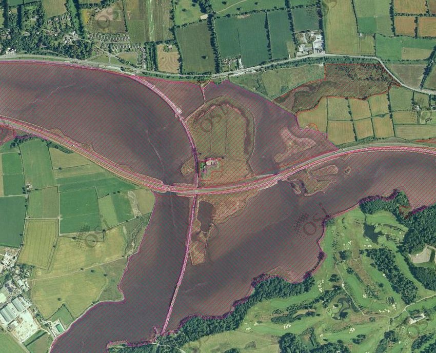
1

                       Harper’s Island Wetlands
                       Conservation Management Plan 2020 - 2024
                       Cork Harbour, Co. Cork

Cork County Council    Prepared by BirdWatch Ireland, on behalf of the Harper’s
         County Hall   Island Steering Group, for Cork County Council
  Carrigrohane Road
               Cork    Funded by Cork County Council through the
                       National Biodiversity Action Plan Fund

                       July 2019
2    Harper’s Island Wetlands

    Contents

      Executive Summary ......................................................................................................... 3

      Introduction: Description & Vision .................................................................................. 5

      Site Information ............................................................................................................... 7

      Evaluation of Ecological Importance ............................................................................. 13

      Evaluation of Capital Works .......................................................................................... 19

      Vegetation Management Considerations ..................................................................... 21

      Objectives & Targets for 2020-2024 .............................................................................. 24

      Summary of Features, Management Actions & Timeframe ......................................... 30

      Appendices .................................................................................................................... 32

    Waterbirds gathered on the wetlands at Harper’s Island (Jim Wilson)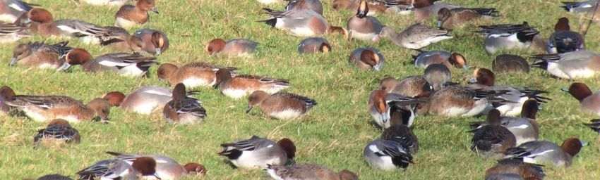
3

Executive Summary

BirdWatch Ireland were commissioned by Cork County Council to prepare a Conservation
Management Plan for the practical management of the habitat zones found within the Harper’s
Island Wetlands reserve in Co. Cork, using best-practice methods. The primary aims of this plan
are to summarise the key conservation species and their current status, the key habitats found
and the management issues, and to outline management actions for these habitats and the key
conservation species so that they can flourish.

Harper’s Island Wetlands reserve is located on a low-lying island within the Cork Harbour complex.
The island is owned by Cork County Council and the wetland reserve area is managed through a
Steering Group comprising of representatives from Cork County Council, BirdWatch Ireland,
Glounthaune Community Association (including Glounthaune Men’s Shed Group and
Glounthaune Tidy Towns) and the National Parks and Wildlife Service.

The extensive Cork Harbour area is designated as a Special Protection Area due to its special
conservation interest for waterbirds, in that it regularly supports over 20,000 waterbirds during
the non-breeding season making this a site of International importance. Harper’s Island and the
surrounding intertidal areas (Glounthaune Estuary/Slatty Water complex) have been identified as
being one of the most important areas for these waterbirds within Cork Harbour, with some 20%
of the waterbirds recorded in Cork Harbour using the Island itself. The area is also designated as
a Special Area of Conservation and Natural Heritage Area because of the occurrence of two
habitats which are listed on Annex I of the Habitats Directive, however neither of these occur
within the reserve area but are adjacent.

The reserve is overlooked by a purpose-built bird hide, accessed from Glounthaune, which was
opened to the public in December 2017. Plans to extend the public access area and facilities are
progressing. Habitat work in recent years has also progressed to improve the conditions for
waterbirds alongside improving the viewing conditions for visitors. Into the future, the Vision is
that the reserve area will continue to be recognised as of high importance for wintering Icelandic
Black-tailed Godwits (Limosa limosa islandica) and the suite of other important waterbird species
found within. This informs the overriding aims for the reserve, which are:

•   to protect and enhance the nature conservation value of Harper’s Island in a manner which is
    compatible with the Conservation Objectives which have been established for the Cork
    Harbour Special Protection Area and the Great Island Special Area of Conservation; and

•   to develop nature based educational and recreational activities consistent with the
    conservation imperative for Harper’s Island, and to thereby encourage public appreciation
    and awareness of nature.

To help deliver on these aims clear management objectives have been agreed and set for the next
5 years, and to fulfil these objectives, management actions have been agreed with targets set to
aide as ‘performance indicators’ for review and these are listed within this plan. The Management
Objectives are as follows: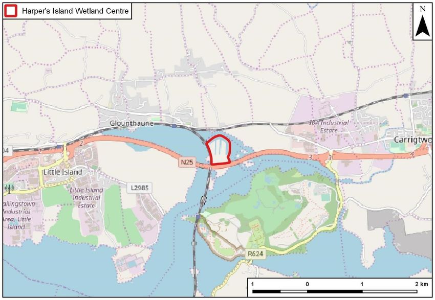
4    Harper’s Island Wetlands

    1.    To manage the Saltmarsh to provide the conditions necessary to maintain its value for
          wintering, feeding and roosting waterbirds without detriment to its potential as an Annex I
          Salicornia habitat;

    2.    To manage the Wet Grasslands to provide the conditions necessary to increase the
          numbers of key wintering waterbirds along with improving the conditions for plants and
          other wildlife, including potential breeding waders and terns;

    3.    To manage the Dry Grassland zone to enhance its botanical diversity and increase its value
          for pollinator species;

    4.    To carry out a Research, Survey & Monitoring programme to inform the management of
          the site and contribute to other recording schemes, surveys and research projects;

    5.    To improve the infrastructure to maximise the visitor experience, enhance the use for
          education and retain support;

    6.    To maintain and improve the integrity of the reserve.

    Acknowledgements

    BirdWatch Ireland would like to thank the staff of Cork County Council who have promoted the
    development of the Harper’s Island Wetlands reserve over the years, notably Martin Riordan
    (retired) and Kevin Lynch (now with Cork City Council) at the original development stage and
    latterly Pádraig Lynch, Sharon Casey and councillor Anthony Barry in continuing to support the
    Vision of the Harper’s Island Group.

    For this Management Plan particular thanks are extended to Tom Gittings for sharing his extensive
    knowledge of the island and the surrounding area, for his many individual written reports on the
    birds and habitats of the island and for producing many of the maps that accompany this plan.
    Thanks also to Jim Wilson and Paul Moore (BirdWatch Ireland Cork Branch), Derry Delany and
    Garry Tomlins (Glounthaune Men’s Shed) and Conor O’Brien (Glounthaune Tidy Towns) who all
    continue to work and strive to fulfil the Vision.

    Thanks also to Mark Carmody, Tom Gittings, Paul Moore, Mark Shorten and Jim Wilson who
    contributed photographs that enhance this plan.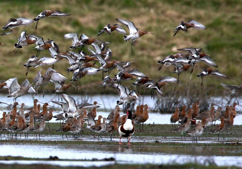
5

Introduction: Description & Vision

Site Description

The Harper’s Island Wetlands reserve in Co. Cork is located within the northern section of Harper’s
Island, bordered by the N25 Cork to Waterford dual carriageway to the south, the Glounthaune
to Cork railway line to the west and the inter-tidal zones of Cork Harbour (Slatty Water) to the
north and east. The reserve area extends to around 17ha and lies within the Cork Harbour
complex. The island is owned by Cork County Council and the wetland reserve area is managed
through a Steering Group comprising of representatives from Cork County Council, BirdWatch
Ireland, Glounthaune Community Association (including Glounthaune Men’s Shed Group and
Glounthaune Tidy Towns) and the National Parks and Wildlife Service.

The extensive Cork Harbour area is designated as a Special Protection Area due to its special
conservation interest for waterbirds, in that it regularly supports over 20,000 waterbirds during
the non-breeding season making this a site of International importance. Harper’s Island and the
surrounding intertidal areas (Glounthaune Estuary/Slatty Water complex) have been identified as
being one of the most important areas for these waterbirds within Cork Harbour, with some 20%
of the waterbirds recorded in Cork Harbour using the Island itself. The area is also designated as
a Special Area of Conservation and Natural Heritage Area because of the occurrence of two
habitats which are listed on Annex I of the Habitats Directive, however neither of these occur
within the reserve area but are adjacent.

Since 2014, Cork County Council, in consultation with BirdWatch Ireland and the Glounthaune
Community Association, have installed a purpose-built bird hide, erected wire mesh fencing and
screening along the public access path, and installed public signage and interpretive boards. These
visitor facilities were further upgraded by the partnership Working Group (representatives from
BirdWatch Ireland Cork Branch, Glounthaune Men’s Shed Group, Glounthaune Tidy Towns and
Cork County Council) in 2017 and opened to the public in December 2017. In addition, the
Working Group (with funding support from Cork County Council) have overseen the creation of
two shallow pools / scrapes (one each in 2017 and 2018) within an area of Wet Grassland near to
the bird hide to improve the conditions for waterbirds and improve the viewing conditions for
visitors. The excavated material from these scrapes was used to form a high earthen bund bank
extending from the bird hide along towards the derelict Farmhouse.

Long-term Vision

Into the future, the Vision is that the reserve area will continue to be recognised as of high
importance for wintering Icelandic Black-tailed Godwits (Limosa limosa islandica) and the suite of
other important waterbird species found within. Their numbers will be maintained, and enhanced
by maintaining the existing habitats, creating new habitats and providing additional feeding and
roosting sites without detriment to the important habitats and wildlife already present. Delivering
these key elements will in turn provide an exemplar of best practice management at the centre
of which will be research, survey and monitoring protocols to inform and guide future
management actions, alongside providing a significant public amenity to the harbour area,
enabling people to visit, enjoy and learn about the birds and other wildlife of the island.
6       Harper’s Island Wetlands

    The overriding aims for the reserve are:

    •     to protect and enhance the nature conservation value of Harper’s Island in a manner which is
          compatible with the Conservation Objectives which have been established for the Cork
          Harbour Special Protection Area and the Great Island Special Area of Conservation; and
    •     to develop nature based educational and recreational activities consistent with the
          conservation imperative for Harper’s Island, and to thereby encourage public appreciation
          and awareness of nature.

    To deliver on these aims clear management objectives are required. These are important in that
    they are an expression of what wants to be achieved. The future conservation management
    objectives for the Harper’s Island Wetlands reserve for the next 5 years (2020-2024) have been
    agreed as follows:

    1. To manage the Saltmarsh to provide the conditions necessary to maintain its value for
    wintering, feeding and roosting waterbirds without detriment to its potential as an Annex I
    Salicornia habitat;

    2. To manage the Wet Grasslands to provide the conditions necessary to increase the numbers
    of key wintering waterbirds along with improving the conditions for plants and other wildlife,
    including potential breeding waders and terns;

    3. To manage the Dry Grassland zone to enhance its botanical diversity and increase its value for
    pollinator species;

    4. To carry out a Research, Survey & Monitoring programme to inform the management of the
    site and contribute to other recording schemes, surveys and research projects;

    5. To improve the infrastructure to maximise the visitor experience, enhance the use for
    education and retain support;

    6. To maintain and improve the integrity of the reserve.

    Wintering Wigeon feeding on the wet grassland at Harper’s Island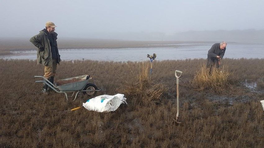
7
Site Information
Location
Site name Harper’s Island Wetlands
Total Area (ha) 17.2
Sea Wall: 1.3
Borrow dyke: 2.9
Saltmarsh: 2.8
Approximate Area (ha) per Habitat Zone
Wet grassland (including scrapes): 5.6
Dry grassland: 3.7
Farmyard: 0.9
Grid ref (centre of reserve) W785727
County Cork
Statutory & other designations
Designation Name Code All or part of site?
SPA Cork Harbour 4030 Part
(excludes Farmhouse)
SAC Great Island Channel 1058 Part
(excludes Farmhouse & area of
grassland around)
pNHA Great Island Channel 1058 Part
(excludes Farmhouse & area of
grassland around)
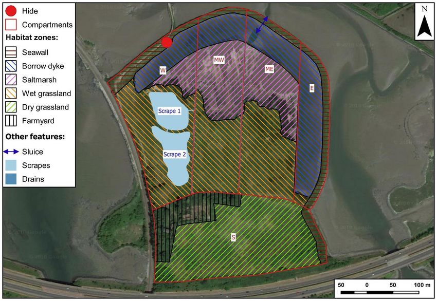
Harpers Island is located within the Cork Harbour Special Protection Area (site code 4030) and
within the Great Island Channel Special Area of Conservation (site code 1058). The SPA is selected
because it regularly supports over 20,000 waterbirds during the non-breeding season making this
a site of International importance whilst the SAC is selected because of the occurrence of two
habitats which are listed on Annex I of the Habitats Directive (1140 Mudflats and sandflats not
covered by seawater at low tide and 1330 Atlantic salt meadows).
The Conservation Objectives for the Cork Harbour SPA1 are:
1. To maintain the favourable conservation condition of the non-breeding waterbird Special
Conservation Interest species listed for Cork Harbour SPA, which is defined by the following
attributes and targets;
a. Target 1: The long-term population trend for each waterbird Special Conservation
Interest species should be stable or increasing. Waterbird populations are deemed to
be unfavourable when they have declined by 25% or more, as assessed by the most
recent population trend analysis.
1
NPWS (2014) Conservation Objectives: Cork Harbour SPA 004030. Version 1.0. National Parks and
Wildlife Service, Department of Arts, Heritage and the Gaeltacht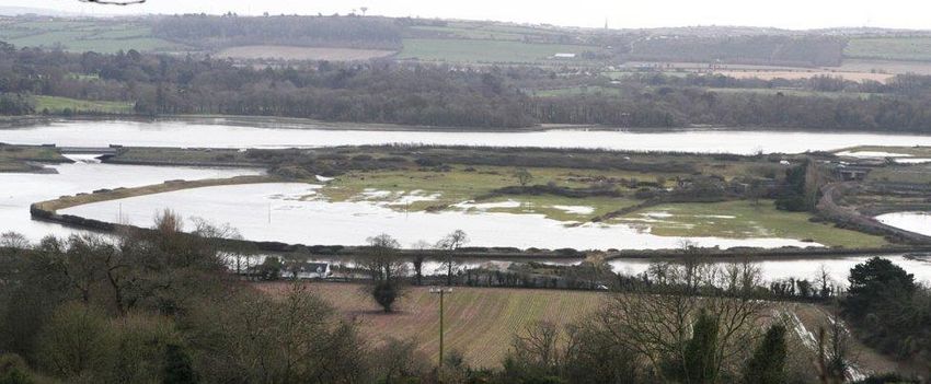
8       Harper’s Island Wetlands

              b. Target 2: There should be no significant decrease in the range, timing or intensity of
                 use of areas by the waterbird species of Special Conservation Interest, other than that
                 occurring from natural patterns of variation.

    2. To maintain the favourable conservation condition of the wetland habitat at Cork Harbour
       SPA as a resource for the regularly-occurring migratory waterbirds that utilise it, which is
       defined by the following attributes and targets;
           a. Target 1: The permanent area occupied by the wetland habitat should be stable and
               not significantly less than the area of 2,587 ha, other than that occurring from natural
               patterns of variation.

    With regards the 22 non-breeding waterbird species of Special Conservation Interest listed for
    Cork Harbour SPA, it has been determined that:
    • 9 species are currently considered as Highly Unfavourable (Pintail (Anas acuta), Shoveler
       (Spatula clypeata), Red-breasted Merganser (Mergus serrator), Cormorant (Phalacrocorax
       carbo), Grey Plover (Pluvialis squatarola), Lapwing (Vanellus vanellus), Black-headed Gull
       (Chroicocephalus ridibundus), Common Gull (Larus canus) and Lesser Black-backed Gull (Larus
       fuscus graellsii));
    • 6 species are currently considered as Unfavourable (Shelduck (Tadorna tadorna), Wigeon
       (Mareca penelope), Great Crested Grebe (Podiceps cristatus), Dunlin (Calidris alpina), Curlew
       (Numenius arquata) and Redshank (Tringa tetanus));
    • 3 species are currently considered as (Intermediate) Unfavourable (Teal (Anas crecca), Grey
       Heron (Ardea cinerea) and Oystercatcher (Haematopus ostralegus)).
    • 4 species are currently considered as Favourable (Little Grebe (Tachybaptus ruficollis), Golden
       Plover (Pluvialis apricaria), Black-tailed Godwit and Bar-tailed Godwit (Limosa lapponica)).

    The Conservation Objectives for the Great Island Channel SAC2 are:

    1. To maintain the favourable conservation condition of Mudflats and sandflats not covered by
       seawater at low tide in Great Island Channel SAC, which is defined by the following list of
       attributes and targets;
         a. Target 1: Permanent habitat area is stable or increasing, subject to natural processes.
         b. Target 2: Conserve the following community type in a natural condition; Mixed
              sediment to sandy mud with polychaetes and oligochaetes community complex.

    2. To restore the favourable conservation condition of Atlantic salt meadows (Glauco-
       Puccinellietalia maritimae) in Great Island Channel SAC, which is defined by the following list
       of attributes and targets;
           a. Target 1: No decrease in habitat extent from the baseline
           b. Target 2: No decline or change in the distribution of these saltmarsh habitats, unless
                it is the result of natural processes, including erosion, accretion and succession
           c. Target 3: Maintain the natural circulation of sediment and organic matter, without
                any physical obstructions
           d. Target 4: Maintain creek and pan networks where they exist and to restore areas that
                have been altered

    2
     NPWS (2014) Conservation Objectives: Great Island Channel SAC 001058. Version 1.0. National Parks and
    Wildlife Service, Department of Arts, Heritage and the Gaeltacht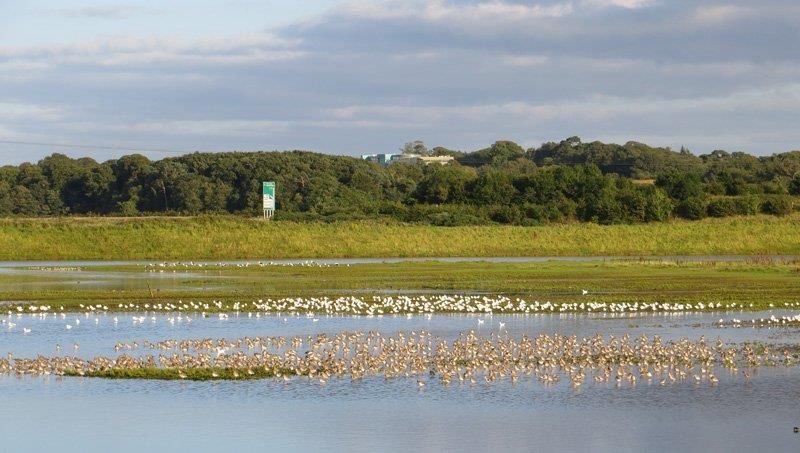
9

         e. Target 5: Maintain a flooding regime whereby the lowest levels of the saltmarsh are
            flooded daily, while the upper levels are flooded occasionally (e.g. highest spring
            tides)
         f. Target 6: Maintain the range of coastal habitats, including transitional zones, subject
            to natural processes including erosion and succession
         g. Target 7: Maintain structural variation within the sward. A general guideline is that
            there should be a sward ratio of 30% tall:70% short across the entire saltmarsh
         h. Target 8: Maintain 90% of the area outside of the creeks vegetated
         i. Target 9: Ensure that a typical flora of saltmarshes is maintained, as are the range of
            sub-communities within the different zones.
         j. Target 10: Negative indicators such as Spartina should be absent or under control.

Harpers Island is surrounded by the Annex I Mudflats and sandflats not covered by seawater at
low tide, and the Saltmarsh vegetation which is potentially equivalent to the Annex I habitat type
Atlantic salt meadows (Glauco-Puccinellietalia maritimae) is identified on Harpers Island on
National Parks and Wildlife Service maps published with the Conservation Objectives. This habitat
however is identified to occur to the west of the railway line and to the south of the N25
carriageway, and therefore does not occur on the part of the Island for which this Conservation
Plan relates.

Under the EU Birds and Natural Habitats Regulations (Article 6(3) and 6(4)) an Appropriate
Assessment needs to be screened or carried out for operations, projects or plans that may impact
on the interests of these sites and are not related to achieving the Conservation Objectives of
Natura interests of designated sites. The Appropriate Assessment is required to be carried out by
the Competent Authority (the licensing authority or approving body) in consultation with National
Parks and Wildlife Service.

Tenure

Freehold

  Folio / Ref No.    Owner                     Agreement date          Site name          Area (ha)
                                                                       Harpers Island
  Folio: CK31741     Cork County Council       13th July 1988                               24.87
                                                                       (north section)
                                                                       Harper’s Island
  Folio: CK46658     Cork County Council       23rd November 1989                            3.31
                                                                       (south section)

Memorandum of Agreement

No formal agreement is in place between Cork County Council on the one part and Birdwatch
Ireland and Glounthaune Community Association on the other part.

An informal agreement between these parties give rights of access to the bird hide and island.
Under these terms, Birdwatch Ireland and Glounthaune Community Association facilitate public
access by opening and closing the access gate, located off Johnston Park road, to the site at times
and dates as agreed with Cork County Council. Birdwatch Ireland and Glounthaune Community
10 Harper’s Island Wetlands
Association also agree to monitor the condition of the access pathway and the bird hide and to
report any issues to Cork County Council. No liability is attached to Birdwatch Ireland or to
Glounthaune Community Association for any incidents or claims which may arise in relation to
their facilitation of public access to this site.
Other Conditions
In 1996, Cork County Council offered the island to the National Parks and Wildlife Service for a
nominal fee. Two conditions of sale were included, these being:
1. That the lands be developed and managed as a Wildlife Habitat
2. That a local Management Advisory Committee to oversee the Management of the Habitat be
put in place and that Cork County Council would have representation as of right on this
Committee
Transfer of ownership was not completed. A Section 183 Notice (Local Government Act 2001) is
now required to transfer ownership of the site formally. This process involves approval from Cobh
Municipal Council before full Council approval. Conditions attached to the Section 183 Notice
would be like those in the original offer. This process is ongoing.
Public access
Public access onto the reserve area is restricted. The main entrance gate, off the Johnstown Park
road leading to Glounthaune, is locked. The gate is opened and closed at set times and dates as
agreed with Cork County Council. Opening times are listed on the Harper’s Island Wetlands
Facebook page (@harpersislandwetland). From the gate, access is then on foot via a screened
tarmac pathway (approximately 260m) leading to a bird hide overlooking the island. At present,
to reduce potential disturbance issues relating to the wintering waterbirds on the island, no
unauthorised public access beyond the bird hide is permissible.
Buildings & hides
Name Comments
Farmhouse, incorporating out buildings & lime kiln Two-story; derelict
Bird hide (concrete foundation / timber construction) Built in 2015; opened 2017
Miscellaneous structures
None
Key Features
Waterbirds
Harper’s Island and the surrounding intertidal areas (Glounthaune Estuary/Slatty Water complex)
have been identified as being one of the most important areas for wintering waterbirds within
Cork Harbour. These include Internationally important populations of Icelandic Black-tailed11
Godwits, with over 1,200 birds roosting and feeding on the island during spring high tides. The
area also supports populations of national importance of three wildfowl and four wader species,
with the reserve area supporting significant components of these populations; these are given in
the following table:
Percentage of Cork
Glounthaune Estuary / Harper’s Island
Species Harbour birds using
Slatty Water (north)
Harper's Island
Internationally important
Black-tailed Godwit 1,653 1,212 41%
Nationally important
Shelduck 247 56 5%
Teal 415 139 11%
Little Grebe 25 11 14%
Golden Plover 1,347 1,199 26%
Curlew 449 229 15%
Dunlin 652 440 9%
Redshank 427 287 17%
Greenshank 21 13 14%
Black-headed Gull 1210 944 27%
Regionally important
Wigeon 576 263 18%
Teal 415 139 11%
Oystercatcher 498 175 10%
Lapwing 775 586 30%
All waterbirds 8,666 5,703 20%
Population figures are means of peak winter counts 2011/12-2015/163
Species listed are those that are of Birds of Conservation Concern in Ireland 4
Habitats
The habitats within the reserve area have been divided into six habitat zones these being the
Borrow dyke, Saltmarsh (Salicornia mud), Wet grassland, Dry grassland, Sea Wall Embankment
and Farmyard (Map 3). These are equivalent to the following habitat types as described in the
Fossit5 classification system and are given in the following table:
3
T. Gittings, unpublished data.
4
Colhoun, K. & Cummins, S. (2013) Birds of Conservation Concern in Ireland 2014-2019. Irish Birds, 9,
523–544.
5
Fossit, J.A. (2000) A Guide to Habitats in Ireland. The Heritage Council12 Harper’s Island Wetlands
Approximate
Habitat Code
Area (ha)
Borrow dyke Lagoon CW1 2.9
Saltmarsh Salicornia CM1 2.8
Grassland Wet (transitional) - 5.6
Grassland Dry (improved/scrub mosaic) (GA1) 3.7
Embankment Sea Wall BL2 1.3
Farmyard Buildings BL3 0.9
Looking towards the purpose-built bird hide from the Salicornia mud habitat (Tom Gittings)
Plants
Three notable species have been recorded; these being Wood Small-reed (Calamagrostis
epigejos) within the Dry Grassland zone, Reflexed Saltmarsh-grass (Puccinellia distans) within the
marginal sections of the Saltmarsh zone and Slender Spike-rush (Eleocharis uniglumis) within the
Wet Grassland zone. A recent survey of the Saltmarsh and Wet Grassland zones recorded 63 taxa6.
6
T. Gittings (2018) Botanical Survey of the saltmarsh and wet grassland zones August to September 2018.
Unpublished report.13 Other Very little information is available on the mammals, fish, reptiles, amphibians or invertebrates. A Bat survey, in and around the Farmhouse and buildings, in 20187 detected five species, these being: Common Pipitrelle (Pipistrellus pipistrellus), Soprano Pipistrelle (Pipistrellus pygmaeus), Leisler's Bat (Nyctalus leisleri), Brown Long-eared Bat (Plecotus auritus) and Natterer's Bat (Myotis nattereri). Of these, the latter is considered relatively rare and so is of high local conservation significance. A pollinator survey recorded Moss Carder Bee (Bombus muscorum) in 2018 (T. Gittings pers comm) which is classified as a Declining species in Ireland8. Evaluation of Ecological Importance Waterbirds Harper’s Island and the surrounding intertidal areas (Glounthaune Estuary/Slatty Water complex) have been identified as being one of the most important areas for wintering waterbirds within Cork Harbour. Waterbirds, defined as ‘birds that are ecologically dependent on wetlands’9, are a diverse group that includes divers, grebes, swans, geese and ducks, gulls, terns and wading birds. These groups have been counted on Harper’s Island since 1995, generally by the ‘look-see’ method10 (T. Gittings pers comm.). Some counts have also been conducted through the I-WeBS scheme11. Some 65 waterbird species have been recorded; half of which would occur each year (T. Gittings pers comm.). Of these around 25 species are regularly recorded (i.e. probably present on at least 25-50% of days during their seasonal period of occurrence) on the Harper’s Island Wetlands reserve. Waterbird numbers vary, which is to be expected as these often depend on the time of year and the presence or absence of open water; numbers being higher when open water areas through to shallow flooding is present during the autumn / winter periods. Different species also tend to occur within specific habitat zones. Mute Swan (Cygnus olor), Little Grebe and Cormorant tend to favour the areas of open water, especially along the Borrow dyke. Similar for Little Egret (Egretta garzetta) and Grey Heron although they often feed along the drainage ditches as well, whilst ducks such as Wigeon tend to feed in the Saltmarsh zone in the autumn and then move into the Wet Grassland zone, especially where the grass is short. The wader species tend to move onto the island as a response to a rising tide and generally roost at high tide on small islands in the Saltmarsh zone and the scrapes within Wet grassland zone, as well as along the northern edge 7 Abbot Ecology (2018) Bat Survey of Harper’s Island Old Farmhouse 2018. Unpublished report. 8 Fitzpatrick, U., T.E. Murray, R.J. Paxton & M.J.F. Brown (2006) The state of Ireland’s Bees. 9 Ramsar Convention Bureau (1971) Convention on wetlands of international importance especially as waterfowl habitat. Ramsar Convention Bureau, Gland, Switzerland. 10 Bibby, C.J., Burgess, N.D., Hill, D.A. & Mustoe, S.H. (2000) Bird Census Techniques Academic Press 11 I-WeBS Counter Manual: Guidelines for Irish Wetland Bird Survey counters. https://www.birdwatchireland.ie/LinkClick.aspx?fileticket=Ih2CTtw9bjs=&tabid=112
14    Harper’s Island Wetlands

     of the Borrow dyke. Gulls tend to favour the areas of open water and the flooded Saltmarsh zones.
     To what extent these habitat zones are used at night is an unknown, although anecdotal sightings
     would seem to suggest that a reasonable number, if not a lot of waterbirds use the island after
     dark. Large numbers can occur, especially to roost, with greater numbers when there is a high
     spring tide.

     An important consideration when assessing waterbird numbers and usage on the reserve is the
     history of water management. It is known that during the 1995/96 and 1996/97 winters the fields
     were subject to extensive semi-tidal flooding from the Borrow dyke, much as they are now. Then,
     possibly due to maintenance of the tidal sluice flap, from late 1997 the fields rarely flooded and
     the Borrow dyke was largely dry until December 2006 when the Borrow dyke was again
     permanently flooded with extensive flooding of the margins of the fields. Thereafter tidal flooding
     occurred frequently and, ultimately, saw the development of the Saltmarsh zone. These changes
     in water management are reflected in the bird count data, which recorded much lower bird
     numbers and diversity during the ‘non-flooding’ period. During this period, only small numbers of
     Lapwing and Curlew (and, less frequently, Black-tailed Godwit) occurred and there were no large
     mixed flocks of roosting waders. So regular tidal inundations, areas of open water and shallow
     flooding are important to maintain the conditions for the waterbird species, especially during the
     non-breeding season.

     View over Harper’s Island Wetlands reserve during high winter floods (Jim Wilson)
15
Mean winter peak counts
Water levels Non-flooded Flooded
4-year winter period 2002/03-2005/06 2013/14-2016/17
Mute Swan 0 9
Shelduck 0 60
Wigeon 0 273
Teal 19 210
Mallard 3 12
Cormorant 0 12
Little Egret 3 14
Grey Heron 1 2
Little Grebe 0 13
Oystercatcher 0 362
Golden Plover 0 1090
Lapwing 35 497
Curlew 10 238
Black-tailed Godwit 25 783
Dunlin 0 419
Greenshank 1 11
Redshank 1 341
Black-headed Gull 1199
Great Black-backed Gull 63
Total wildfowl 26 607
Total waders 102 3760
Total gulls 1296
Key bird species profiles
Wigeon
In recent winters, the mean number is around 275 birds which reflects the improved habitats and
extensive shallow flooding now present. Generally, they appear to show a tidal pattern, feeding
within the Saltmarsh and Wet grassland zones and when disturbed, retreating to the open water
of the Borrow dyke or the scrapes. On a rising tide they move out onto nearby Brown Island North
to feed in shallow sub-tidal waters as it floods over the saltmarsh. Small numbers also occur
around the mussel beds in the Glounthaune Lower (east) sector at low tide and in the Railway
Pool (east) sector on a rising tide.
Golden Plover
In some winters Golden Plover numbers can be in excess of 2,000 birds, however the mean
number is around 1,000 birds using the wetlands. They appear to use the wetlands as a roosting
site, as well as (although to a lesser extent) within the Glounthaune Lower (east) and Railway Pool
(east) sectors. However, this roosting behaviour is erratic and seems independent on tide levels,16 Harper’s Island Wetlands
as flocks come into roost for short periods and then disappear. There favoured roosting location
on the island being in the Saltmarsh zone where they roosted around the margins.
Lapwing
Generally, around 500 birds occur in the winter and appear to use the wetlands as a roosting site
with the highest numbers recorded around high tide. They seem to favour the Saltmarsh zone to
roost, especially around the margins. Some birds do feed in the Wet Grassland zone. At low tide,
some are also noted around the mussel beds in the Glounthaune Lower (east) sector, while on a
rising tide they tend to move into the Brown North and Railway Pool (east) sectors.
Dunlin
The mean number of Dunlin wintering is around 420 birds although in some winters over 1,000
can occur. They are generally recorded feeding out on the extensive mudflats, and then on a rising
tide move onto the reserve to roost along the edge of the Saltmarsh zone.
Curlew
The mean number of Curlew wintering is around 240 birds. They are mostly recorded in small
numbers, but numbers increase as birds move onto the reserve to roost. This is a consistent
pattern observed in this area over many years (Tom Gittings pers. comm.). The majority feed in
the surrounding fields during the day and return to roost at night.
Redshank
Around 340 birds winter in the area and, as the tide rises, they move onto the reserve to roost.
Generally, they feed out in the estuary, but a few birds do feed in the Saltmarsh zone, as well as
around the scrapes in the Wet grassland zone. Highest numbers occur from late June to
September with a peak count of 920 in July 2017.
Black-tailed Godwit
Black-tailed Godwits, at low tide are distributed throughout the Glounthaune Estuary during the
winter. The mean number using the reserve is around 785 birds and these, generally, occur in the
Saltmarsh zone, roosting within the margins. However, peak numbers tend to occur during the
spring months with counts of over 1,600 birds during late March and April i.e. up to 3% of the
world’s population of the Icelandic subspecies. In April 2018, the peak count reached 2,800 birds.
During the spring and autumn migrating periods, when they are migrating back and forth to their
northern breeding grounds from further south and east in Europe, the reserve has been shown,
through long term colour ringing studies, to be an important ‘re-fuelling’ site. At this time, they
feed throughout the habitat zones found on the island, from the Saltmarsh zone to the Dry
grassland zone.
Habitats
Harper’s Island is surrounded by the Annex I habitat, Mudflats and sandflats not covered by
seawater at low tide [1140] and on the island the saltmarsh vegetation which is potentially
equivalent to the Annex I habitat type Atlantic salt meadows (Glauco-Puccinellietalia maritimae)
[1330] has been identified. However these are outside of the area that is covered by the Harper’s
Island Wetlands reserve.17 The reserve area has been divided into six broad habitat zones (Map 3); these have been adopted for consistency with criteria produced for waterbird counts and other monitoring on the reserve. The habitat zones are (i) the Sea Wall embankment which encloses the northern and eastern sides of the island, (ii) the Borrow dyke which is a wide trench that was excavated over the years to build up the Sea Wall, and is now a permanently flooded lagoon, (iii) an area of Saltmarsh (sometimes referred to as the Salicornia zone) which is regularly flooded, especially in winter, (iv) Wet Grassland which is beyond the limit of tidal flooding and, generally, has a high soil water table often producing shallow flooding in winter, as well as two permanent shallow pools / scrapes, (v) Dry Grassland on the higher ground leading to the N25 dual carriageway, within which is (vi) the Farmyard area consisting of derelict buildings and scrub. The hydrology of the reserve appears complex and poorly understood12, although it is known to be a key factor on the distribution of the habitats found, with the main influence being the tidal inundations through a sluice located within the Sea Wall embankment. Originally this sluice was constructed to let water out of the island while preventing tidal water entering, through a tidal flap design. Its current status is unknown (as it is difficult to access) but it has not been operating as designed since around 2006. This has therefore seen the development of the lagoon habitat in the Borrow dyke and the Saltmarsh habitat. Extensive siltation has also taken place in the Borrow dyke with an estimated 1.5 m depth of silt over large parts of the dyke. In recent years, it has also been noted that there has been some tidal seepage through the Sea Wall, especially on spring high tides. While tidal water inputs are important for developing and maintaining the brackish habitats, the grassland zones appear to be influenced more by freshwater. With no known freshwater springs, the key factor in these areas appears to be rainfall levels. This is most evident in winter, when after periods of heavy rainfall the Wet Grassland zone becomes saturated. The wetland zones from the Borrow dyke, through the Saltmarsh and leading onto the Wet Grasslands are the areas of primary importance for the waterbirds on the reserve, for either feeding, roosting or both. With regular tidal inundation, since 2006, the developing Saltmarsh has become dominated by Glasswort (Salicornia agg.) but with other plants, such as small patches of Common Saltmarsh-grass (Puccinellia maritima) developing in places. This Glasswort dominated saltmarsh corresponds to the Annex I habitat [1310] Salicornia and other annuals colonising mud and sand. This is a very rare habitat in Cork Harbour and the reserve area probably holds by far the largest and best-developed example in the harbour 13 . Prior to dying back in the winter, Glasswort produce seeds which provide a food resource for Wigeon and Teal during the autumn and the open structure of the vegetation with plenty of exposed mud between the plants provides good foraging habitat for waterbirds such as Teal, Curlew, Black-tailed Godwit, Dunlin and Redshank, as well as providing suitable open habitat conditions for roosting waders. The marginal sections of the Saltmarsh zone contain a more diverse vegetation structure, mainly dominated by dense stands of Saltmarsh Rush, interspersed with Common Saltmarsh-grass. If the latter continues to spread, the vegetation in the Saltmarsh zone may develop into the Annex I habitat [1330] Atlantic salt meadows, which is a qualifying interest of the Great Island Channel SAC. This could be a positive development but may well reduce the value of the Saltmarsh zone as a feeding 12 T. Gittings (2018) Harper’s Island Wetland Centre: Brief for preliminary hydrological assessment. Unpublished report. 13 T. Gittings (2018) Botanical Survey of the saltmarsh and wet grassland zones August to September 2018. Unpublished report.
18        Harper’s Island Wetlands

     and roosting habitat for waterbirds, and therefore maintaining it as the potential Annex I habitat
     [1310] Salicornia and other annuals colonising mud and sand maybe more beneficial.

     The Saltmarsh zone transitions into the Wet Grassland zone which was formerly species-poor
     improved grassland, grazed by sheep up to 2006. Thereafter the Saltmarsh and Wet Grassland
     zones have been grazed by horses through until spring 2017 when all grazing ceased. The Wet
     Grassland appears to be influenced by salinity levels in the soils (based on the plant species found)
     with a salinity gradient from east to west. These grasslands do not usually flood but become
     heavily waterlogged in winter with small pools of standing water forming during periods of very
     wet weather. The diversity of the vegetation has increased significantly over the years into a
     species-poor neutral grassland supporting, given the strong brackish influence, some halophytic
     plant species in the eastern section. Saltmarsh Rush is present throughout the Middle East
     compartment and Reflexed Saltmarsh-grass and Sea Club-rush occurs in the small pond in the
     middle of this area. The Middle West compartment is the most species-poor and the West
     compartment lacked any brackish components but had a more freshwater wetland character. The
     grassland sward is dominated by Creeping Bent, Common Couch and Yorkshire-fog, with large
     patches of Silverweed and frequent docks but does contain patches of Common and Slender
     Spike-rushes as well as other species indicative of wet ground conditions such as Jointed Rush and
     Marsh Foxtail.

     The rest of the grasslands (Dry) are generally a mosaic of improved agricultural grassland with
     some scrub which are not affected by flooding but does contain some small brackish wetland
     depressions. The area contains stands of the rare Wood Small-reed plant and Oak saplings have
     become established in areas where Bramble scrub has protected them from grazing. Within this
     area are the old and now partially derelict farm buildings as well as the large embankment of the
     N25 dual carriageway which supports dry meadows and grassy verges with some gorse scrub.

     Plants

     Three notable plant species have been recorded within the reserve area. Most notable is Wood
     Small-reed which is listed on the Flora Protection Order 201514 and as Vulnerable on The Red Data
     List of Irish Plants 15 i.e. a species that is currently not endangered but would be extremely
     vulnerable if their habitats are disturbed in the future. As such a licence would be required from
     the National Parks and Wildlife Service for any work that would interfere with the plants or their
     habitat. The plant was first discovered in 2009, growing in an area that was excavated as part of
     the construction of the N25 dual carriageway, which would indicate that the population must be
     of recent origin. A comprehensive survey, as part of a rare plant survey of Co. Cork in 201216,
     recorded a total of around 500 clumps comprising 45 flowering heads in an area of 12x30m2 within
     the original area where it was initially discovered i.e. within the Dry grassland zone. The threats
     to the plants was listed as scrub encroachment and therefore recommend continuing grazing to
     aide against scrub succession.
     14
        Statutory Instrument No. 365 of 2015: Flora Protection Order 2015.
     15
        Wyse Jackson, M., FitzPatrick, Ú., Cole, E., Jebb, M., McFerran, D., Sheehy Skeffington, M. &
     Wright, M. (2016) Ireland Red List No. 10: Vascular Plants. National Parks and Wildlife Service.
     16
        Curtis, T., Wilson, F., Conaghan, J., Fuller, J., Roden, C. and Murphy, P. 2012. Field Survey of Rare,
     Threatened and Scarce Vascular Plants in Ireland 2012. Unpublished report to National Parks and Wildlife
     Service.
19 The other two species, Reflexed Saltmarsh-grass and Slender Spike-rush are scarce species within Co. Cork but are quite widely distributed elsewhere around the Irish coast. Reflexed Saltmarsh- grass has only recolonised the island in the last few years. It occurs in the upper edges of the Saltmarsh zone having formerly occurred along the base of the Borrow dyke but disappeared once this became a permanent lagoon. Slender Spike-rush also occurs in the transitional area from the Saltmarsh to the Wet Grassland. Three non-native invasive plant species have also been recorded. Himalayan Knotweed (Persicaria Wallichii) and Winter Heliotrope (Petasites fragrans) occur along the public access track to the bird hide. These were both chemically treated during the construction work for the bird hide17. Following treatment, there has been some regrowth of Winter Heliotrope but very little regrowth of Himalayan Knotweed. The other invasive species is Common Cord-grass (Spartina anglica) which is a potential threat to the Saltmarsh zone. It has colonised extensive areas of the mudflats in the Belvelly area of Cork Harbour and is also quite widespread in the Glounthaune Estuary and Slatty Water. It was first noted on Harper’s Island in the summer of 2017, when three established stands were present which has now extended to five established stands, indicating that the rhizomes are starting to spread rapidly. If left, it will start to smoother the natural saltmarsh ecosystem and prevent birds like waders from feeding on the open mud. Any control is a notifiable action which will require consent from National Parks and Wildlife Service. Evaluation of Capital Works Developments, linked with creating a flagship wetland reserve on the northern section of the island were instigated by Cork County Council, in partnership with BirdWatch Ireland and the Glounthaune Community Association, in 2014. One of the aims being to develop a visitor / educational facility to provide greater public access, an awareness and appreciation of the reserve; the first phase being to construct a bird hide along with associated infrastructure. These plans went through the statutory processes20 (including Appropriate Assessment screening) and were constructed in 2015. The works included upgrading the existing path from the railway overpass (inside the main entrance) to the bird hide, installing wire mesh fencing and screening along the path to prevent disturbance to feeding and roosting birds, building a three-sided bird hide overlooking the Borrow dyke and Saltmarsh / Grassland zones and installing signage and interpretive boards. The bird hide was constructed using pressure treated timber for the internal and external structure, with industrial steel mesh floors, sitting on a series of augured concrete footings (reinforced concrete tubes) as foundations. The bird hide was originally envisaged as being open at the rear. However, to facilitate extra seating and large interpretation boards, a rear wall was installed in 2017 along with hide seating, window arm rest shelving, general signs and interpretative boards featuring bird identification and bird migration. The bird hide was officially opened in December 2017. 17 Habitats Directive Screening Report for Harpers Island Development Project – Phase I Feb 2014, Cork County Council.
20 Harper’s Island Wetlands
Other capital works has included the construction of two shallow pools / scrapes (one each in
2017 and 2018) and earthen bunding banks. The scrapes were excavated in the western
compartment of the Wet Grassland zone and are pools designed to provide shallow water depths
and exposed mud habitat for waterbirds. The initial scrape also has two small islands in the middle
with a deep-water channel (around 1 m deep below ground level) surround which connects to a
linear drain via a water control drop board sluice. Since its creation there have been around 25
waterbird species recorded as associated with the scrape, including a pair of Little Ringed Plovers
(a rare species in Ireland) during summer 2018. Tractor mounted flail mowing of the grassland
surrounding these scrapes has been done each autumn since 2017. The excavated material from
the construction of these scrapes was used to form a high earthen bund bank extending from the
bird hide along to the Farmyard zone to act as screening to facilitate a proposed nature trail
leading through to the Dry Grassland zone and the site of the proposed Harper’s Island Wetland
Interpretive Centre.
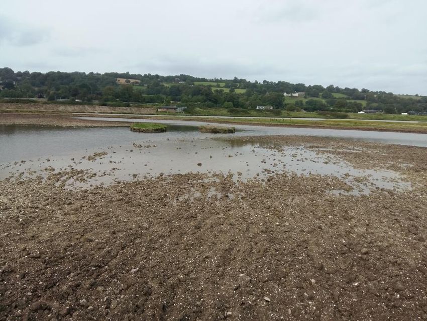
Created scrape area nearing completion to improve habitats for waterbirds (Tom Gittings)21 Vegetation Management Considerations Livestock Grazing Regime Generally, for the Saltmarsh and grassland habitats found on the reserve, a varied vegetation structure is important for maintaining species diversity and is particularly important for birds and invertebrates. To attain such a varied structure, grazing is often used but stocking levels (in conjunction with type of grazing animal) need to be appropriate as these produce different outcomes; heavy grazing can lead to loss of diversity and destruction of the vegetation cover, while no or light grazing can lead to a loss of plant diversity due to competitive exclusion. The reserve area has, prior to the flooding of the area in 2006, been grazed by sheep and since then on an ad-hoc informal basis by horses (up until 2017); these have tended to roam unrestricted over the area. Stocking densities have not been monitored over this time, but the grazing (in recent years) has generally created a weedy vegetation structure within the upper Wet Grassland zone that is not ideal for wintering waterbirds. Even so, to enhance the nature conservation of the reserve (in line with the overarching Conservation Objectives for the SPA) then, at the appropriate levels and times, grazing would be considered as key to managing the grasslands and Saltmarsh. For the grasslands, cutting with a tractor mounted flail mower or similar may also be required, particularly in the autumn to attain the suitable grass sward height for the wintering waterbirds, especially Wigeon. There is considerable variation between different types (and ages) of animals in terms of their grazing preferences. Sheep tend to nibble the vegetation and be selective, at least initially, and can therefore create a uniformly low sward height. At high stocking densities, this might be right back to the root stocks. Whereas cattle prefer to eat longer vegetation using their tongue to pull material into the mouth before its bitten off. Cattle are therefore generally better at creating and maintaining a structurally diverse sward. They also trample the ground more significantly which, in moderation, is beneficial as it opens the sward. Their dunging behaviour (cow pats scattered randomly) also creates a series of taller sward ‘islands’ among shorter swards due to a ‘zone of avoidance’ around each pat where the animals will not graze. This can be a valuable feature for insect communities. However, cattle need more water than sheep and, depending on the salinity of the water, may require the provision of freshwater troughs. Horses and ponies preferentially take grass and can produce very short swards, but they will also take a wide range of sedges and rushes and can produce a structurally varied sward. So, the options for establishing a grazing regime are based on five criteria: • Species of grazing animal - cattle, sheep, ponies or other; • Stocking density - number and size of grazing animals; • Duration of grazing - time for which grazing is allowed; • Season of grazing - months during which grazing is allowed; • Grazing system – sequence and pattern of grazing events. The process of establishing an appropriate grazing regime is usually based on 'best-guess', and it is often difficult to decide what is appropriate until something has been tried. However with the focus of the reserve being its wintering waterbird populations then a seasonal summer grazing regime would be preferred to reduce the elements of disturbance during the winter. Therefore,
22        Harper’s Island Wetlands

     the focus revolves around producing a variable sward during the summer months culminating in
     a short sward for the winter. A mixed grazing regime may therefore be beneficial but practical
     considerations such as the availability of grazing animals may dictate which regime is used.

     What is generally recommended are Annual Stocking Levels of between 0.25 and 0.50 Livestock
     Units per hectare for grasslands and Saltmarsh18. For a ‘summer’ grazing regime i.e. a 24-week
     grazing period between April and October this would equate to around 1 cow or 1 horse or 3 to 4
     sheep per hectare. These are guideline figures as a starting point and should be monitored in
     terms of grazing animal used and their effects in the differing habitat zones. Grazing animals may
     not graze each zone to the desired level or appropriate rate, leading to localised over- or under-
     grazing, and therefore appropriate animal management may need to be implemented e.g. using
     fencing to restrict or confine grazing from or to areas. Overall though flexibility is needed to match
     the grazing intensity to the required habitat and ultimately the conservation objective.

     Management of Common Cord-grass (Spartina anglica)

     Common Cord-grass is a vigorous perennial non-native grass that occupies the lower intertidal
     zone and is listed on the Invasive Species List19. It is a potential conservation problem in that it can
     successfully out-compete other species of the intertidal area such as Salicornia and smother the
     open mud habitat that are important feeding areas for the migrating and wintering waterfowl.

     Within Cork Harbour, the plant has colonised extensive areas of the mudflats in the Belvelly area
     and is also quite widespread in the Glounthaune Estuary and Slatty Water. It was first noted on
     Harper’s Island in the summer of 2017, when three established stands were present. By 2018
     there were five established stands, indicating that the rhizomes are starting to spread rapidly. To
     counteract this a programme of hand-digging out the five established stands was started in
     January 2019, following Ministerial Consent from the Department of Culture, Heritage and the
     Gaeltacht. One stand was removed, and the material bagged and placed on higher ground. The
     effectiveness of this will be monitored and any re-growth recorded. The other four stands remain
     in situ, each covering approximate 2m2.

     Along with hand-digging, several other control techniques have been tested20,21 at many locations
     within Europe and further afield. These have included the use of herbicides, smothering, burning,
     biological control and roto-burying. Despite providing some evidence of achieving an element of
     control there is no evidence to prove that anyone of these techniques is better than the others;
     complete removal has only been successful where there is only a small sward of young plants, and
     even then, continuous monitoring and further management has been necessary.

     18
        Chapman, P. 2007. Conservation Grazing of Semi-natural Habitats. Technical Note 586. The Scottish
     Agricultural College.
     19
        Stokes, K., O'Neill, K. & McDonald, R.A. 2004. Invasive species in Ireland. Unpublished report to
     Environment & Heritage Service and National Parks & Wildlife Service. Quercus, Queens University
     Belfast, Belfast.
     20
        Lacambra, C., Cutts, N., Allen, J., Burd F., & Elliott, M. 2004. Spartina anglica: a review of its status,
     dynamics and management. Institute of Estuarine and Coastal Studies, University of Hull. English Nature
     Research Reports Number 527.
     21
        Adnitt, C., Brew, D., Cottle, R., Hardwick, John, S., Leggett, D., McNulty, S., Meakins, N. & Staniland, R.
     2007. Saltmarsh management manual. DEFRA / Environment Agency Flood and Coastal Erosion Risk
     Management R&D Programme Technical Report SC030220. Environment Agency, UK
23 Hand-digging and removing a clump of the non-native Common Cord-grass Spartina angelica (Paul Moore) Physical removal through hand-digging is perhaps the cheapest control method however, it is a very labour-intensive process that appears only to be effective for single plants and small clumps and it is unlikely that all rhizomes are removed when clumps are bigger than 15cm in diameter22. Whereas using selective herbicides, such as Dalapon (no longer manufactured), Fluazifop, Haloxyfop and Imazapyr have proved an effective control method for larger areas in that it has been found to reduce the live stem density by over 95%; in contrast broad range herbicides, such as Glyphosates (e.g. Roundup) have been found to be relatively ineffective23. For Glyphosates to be more effective it needs to be mixed with a surfactant/adjuvant to help it stick to the leaf surface and thus increase herbicide uptake prior to being washed off. However, re-growth or seedling colonization occurred following all herbicide treatments over two years, indicating that the root and rhizome systems were not killed off and that repeated applications at 3 or 4 yearly intervals may be required. On the other hand, roto-burying (technique consists of a tractor-mounted device that buries the plant to a depth that does not allow recovery or regeneration) is considered a successful management technique that does not require as much labour as hand-digging, does not add any chemicals to the environment and does not lead to Spartina spread. However, it cannot be used in soft sediments and there are concerns about its use in relation to the potential impacts on the invertebrate community24,25. Another effective method is that of smothering the plants with thick black plastic sheeting pinned down with galvanised steel mesh. This blocks out any sunlight thereby prevents photosynthesis and thus leads to plant death. Although there are 22 Dyke, C., 1998. Strategy for the management of rice grass (Spartina anglica) in Tasmania, Australia. Rice Grass Advisory Group. Tasmania: Department of Primary Industries, Water and Environment. 23 Hammond, M.E.R. 2001. The experimental control of Spartina angelica and Spartina x townsendii in estuarine salt marsh. Thesis submitted to Faculty of Science Environmental Studies, University of Ulster, Northern Ireland. 24 Denny, M.J.H. & Anderson, G.Q.A. 1998. Rotoburying Spartina anglica swards at Lindisfarne NNR, Northumberland: the effects on benthic infauna. Unpublished report to English Nature. 25 Harwood, T.R. & Scott, R., 1999. Spartina anglica control Grange-Over-Sands 1988- 1999. Unpublished report to South Lakeland District Council, UK
24       Harper’s Island Wetlands

     some problems with this method, in that it can be a labour-intensive technique especially when
     dealing with large areas that require treatment over extended periods of time (i.e. 6 months),
     studies have reported kill rates of up to 99-100%23.

     If total eradication of Spartina is not the aim or is seen as unobtainable due to the environmental
     disadvantages of the various techniques, then an effective grazing regime using cattle and sheep
     appears to be an effective technique for at least controlling it20, and this coupled with hand-
     digging of seedlings and young plants could fulfil the conservation objective at this stage.

     Objectives & Targets for 2020-2024

     The overriding aims for the reserve are:

     •     to protect and enhance the nature conservation value of Harper’s Island in a manner which is
           compatible with the Conservation Objectives which have been established for the Cork
           Harbour Special Protection Area and the Great Island Special Area of Conservation; and
     •     to develop nature based educational and recreational activities consistent with the
           conservation imperative for Harper’s Island, and to thereby encourage public appreciation
           and awareness of nature.

     To deliver on these aims clear management objectives are required. These are important in that
     they are an expression of what wants to be achieved. They must be measurable, and this is
     achieved by including targets that are directly linked to, and part of, the objective.

     Rationale for Management

     The Harper’s Island Wetlands reserve is located within the extensive Cork Harbour area,
     recognised for its Internationally Important wintering waterbird populations. The reserve area
     and its environs are arguably some of the most important sites for all the waterbird assemblages
     in the Cork Harbour SPA supporting a range of species of Birds of Conservation Concern in Ireland.
     The reserve area now includes a habitat mosaic of Saltmarsh merging into Wet and Dry grasslands
     which have been ‘farmed’ to varying degrees of intensity over the years. To ensure its importance
     into the future, the habitats will be managed and enhanced with wintering waterbirds at its core
     but without detriment to the important plants and other wildlife also found. At the centre of this,
     research, survey and monitoring will inform and guide the management actions.

     Conservation Objectives

     1. To manage the Saltmarsh to provide the conditions necessary to maintain its value for
        wintering, feeding and roosting waterbirds without detriment to its potential as an Annex I
        Salicornia habitat

     Species targets:
     • Maintain and/or increase the 5-year average peak counts of wintering waterbirds at ≥ 4,000
        birds (in conjunction with the Wet grassland zone)
You can also read