Fens of the Sierra Nevada, California, USA: patterns of distribution and vegetation
←
→
Page content transcription
If your browser does not render page correctly, please read the page content below
Fens of the Sierra Nevada, California, USA:
                           patterns of distribution and vegetation
                                         E.C. Wolf and D.J. Cooper

                 Department of Forest and Rangeland Stewardship, Colorado State University, USA
_______________________________________________________________________________________

SUMMARY

A broad sample of 79 montane fens in the Sierra Nevada revealed that underlying geology and topography
exert strong control over the distribution and vegetation of these ecosystems. Distinct granodiorite,
metamorphic, volcanic, carbonate and serpentine bedrock geology resulted in very different water chemistry,
which had significant effects on the particular plant species found at each site. Wide-ranging values of pH
(4.28–8.00) and dissolved cation concentrations (1.6–62.0 mg L-1) spanned the categories of transitional poor–
rich to extremely rich fens. The vegetation of a pair of fens on carbonate bedrock and two floating mat fens
was markedly different from the vegetation recorded at any other study sites. Once these outlier fens were
removed from the analyses, the environmental variables that correlated most closely with the vegetation data
were pH, altitude, presence of volcanic bedrock and fen slope. The measured environmental parameters
explained 9.7 % of the variability in the vegetation data. Species richness was primarily (and negatively)
correlated with altitude. Peat thickness (15–253 cm) was constrained in smaller catchments and on steeper
slopes, and was positively correlated with soil organic matter content (16–92 %). Of the four typical fen
landforms (bedrock contact, slope, spring mound and basin), sloping fens were the most common (63 % of the
79-fen sample).

KEY WORDS: bedrock, geomorphology, peatland, species richness, water chemistry
_______________________________________________________________________________________

INTRODUCTION                                               and erosion expose highly variable bedrock types so
                                                           that water (surface and groundwater) flowing through
Peatland formation requires a specific combination of      mountain systems acquires different chemical
physical and biological processes that most                characteristics depending on the local lithology.
commonly occur in low-relief tropical and boreal           Water chemistry profoundly influences peatland
regions of the world. Perennial soil saturation, very      vegetation (Cooper & Andrus 1994, Lemly & Cooper
low mineral soil deposition and erosion rates, and net     2011). Steep mountain topography also promotes
storage of soil carbon resulting from plant                drainage and, thus, rapid drying of soils, high soil
productivity must coexist for centuries or millennia       erosion rates on slopes and high mineral sediment
to form peat soils (Moore & Bellamy 1974). Suitable        deposition rates in valleys and basins (Patterson &
conditions for peatland formation are of limited           Cooper 2007).
occurrence in mountain landscapes (Cooper et al.              The distinctive characteristics of mountains
2012). For example, peatlands occupy 1.0 % of the          include large altitudinal and climatic ranges, complex
land surface area in the Beartooth Mountains of            migratory pathways for biota, large floras with
Wyoming, USA (Heidel & Rodemaker 2008), 1.0 %              diverse biogeographical connections and histories
of the San Juan Mountains in Colorado, USA                 (Weber 2003, Cooper et al. 2012), and high species
(Chimner et al. 2010), 2.5 % of the Snowy Mountains        and community-level biodiversity (Bedford &
in New South Wales, Australia (Hope et al. 2012) and       Godwin 2003). As a small areal component of the
0.4 % of the autonomous region of Galicia in north-        landscape,     mountain peatlands support a
west Spain (Pontevedra-Pombal et al. 2006).                disproportionate diversity of plant species (Jones
Preliminary measurements in the Sierra Nevada,             2011, Sekulová et al. 2013) and provide important
from Sequoia and Kings Canyon National Parks               habitat for insects (Holmquist et al. 2011) and many
(California, USA), indicate that peatlands cover           other organisms (Bedford & Godwin 2003). In
approximately 0.2 % of the land area (Hopkinson et         addition to their importance for flora and fauna, many
al. 2013).                                                 mountain peatlands have accumulated organic
    Mountain ranges are highly variable landscapes         carbon for millennia (Wood 1975), allowing
created by glaciers, hillslope erosional processes and     prehistoric climate and vegetation to be reconstructed
geological forces such as faulting and uplift. Uplift      (Anderson & Smith 1994). While the quantity of

       Mires and Peat, Volume 15 (2014/15), Article 08, 1–22. http://www.mires-and-peat.net/, ISSN 1819-754X
                   © 2015 International Mire Conservation Group and International Peat Society                 1
E.C. Wolf & D.J. Cooper FENS OF THE SIERRA NEVADA, CALIFORNIA, USA
stored carbon in some mountain peatlands is minor           Cascade Range and Klamath Mountains, to cover a
with respect to the global carbon budget, the               broad range of mountain peatland occurrences
preserved record of climate and vegetation over the         throughout California.
past several thousand years is invaluable. Because of           The dominant bedrock type varies across this
their relative scarcity, their value for biodiversity and   large study area. Granodiorite (a quartz-rich
wildlife, and their importance as records of past           crystalline intrusive rock similar to granite)
ecological conditions, mountain peatlands have              dominates the central and southern Sierra Nevada,
become priority research and conservation targets for       while volcanic rocks form the Cascade Range.
land management organisations around the world              Metamorphic belts are exposed in the northern Sierra
(Bragg et al. 2003, Michael Succow Foundation               Nevada and on its west- and east-facing slopes, as
2014, Wetlands International 2014) and in the               well as in the Klamath Mountains. Very localised
western USA (Chadde et al. 1998, Sikes et al. 2013).        exposures of carbonate metasedimentary rocks such
Mountain peatlands exist within a highly variable           as marble, and ultramafic metavolcanics like
physical template, making them diverse and                  serpentine, occur within the metamorphic belts.
challenging to understand. Specifically, it is unclear          There is a strong north–south precipitation
what physical factors control mountain peatland             gradient (see Figure 1), with annual precipitation
distribution and plant biodiversity.                        ranging from > 200 cm in the north and west to
    The Sierra Nevada of California is one of the           < 65 cm in the south and east. The climate of the
largest and most continuous high mountain ranges in         Sierra Nevada is characterised by wet winters with
North America. A few mountain vistas (e.g.                  abundant snowfall above approximately 1,600 m
Yosemite Valley) are world-famous icons and the             altitude (snowfall is 70–90 % of annual precipitation)
majestic conifer forest vegetation has been well            and dry summers with only 10–30 % of annual
studied (Ratliff 1985, Barbour 1988, Fites-Kaufman          precipitation falling between June and October
et al. 2007). However, relatively little is known about     (Fites-Kaufman et al. 2007). Therefore, peatlands
the diversity of wetlands in the Sierra Nevada. One         must be kept saturated through the four-month
of the first peatlands described in the western USA is      growing season (July–October) by groundwater
in California (Rigg 1933, Baker 1972, Erman et al.          discharge with minor supplementation by direct
1977), but there have been relatively few studies of        rainfall. During the spring of each year, the melting
peatlands since then (Beguin & Major 1975, Burke            snowpack recharges the aquifers that supply the
1991, Bartolome et al. 1990, Allen-Diaz 1991).              groundwater discharge in summer (Cooper et al.
    The goal of this study is to characterise the flora,    2015). Because all peatlands in the Sierra Nevada
vegetation, soils, geochemistry, physical setting and       must rely primarily on groundwater to remain
landforms of representative peatlands in the Sierra         saturated they are classified as minerotrophic
Nevada, southern Cascade Range and nearby                   peatlands, or fens (Rydin & Jeglum 2013), as
Klamath Mountains in California, focusing primarily         opposed to ombrotrophic (rain-supported) bogs.
on the Sierra Nevada. We specifically addressed the
following questions: (1) are peatlands present in all
regions of the study area? (2) are the abundance,           METHODS
distribution and development of peatlands influenced
by landscape-scale factors? and (3) how do physical         Site visits
site characteristics influence peatland vegetation and      Potential fens were initially identified using natural
floristic biodiversity?                                     colour air photos and topographic maps. Sites for
                                                            field visits were chosen to represent the range of
                                                            altitudes and habitats occurring within the mountain
STUDY AREA                                                  ranges, and for ease of accessibility. A total of 79 fens
                                                            were visited: 2 in the Klamath Mountains (Shasta-
The Sierra Nevada mountain range runs north–south           Trinity NF), 11 in the Cascade Range (Lassen NF and
for 640 km in the east of the state of California, USA.     Lassen NP), and 66 in the Sierra Nevada (Plumas,
The highest peak is Mount Whitney (4,421 m). To the         Tahoe, Eldorado, Stanislaus, Inyo, Sierra and
north and north-west are the Cascade Range and the          Sequoia National Forests, and Yosemite NP; see
Klamath Mountains, which are regarded by earth              Appendix). We delineated each fen’s catchment area
scientists as contiguous but distinct geomorphic            and determined its altitude, predominant catchment
provinces (Figure 1). Our goal was to sample                bedrock type (granodiorite, metamorphic, volcanic,
peatlands in each National Forest (NF) throughout           carbonate or serpentine) and average annual
the Sierra Nevada, with limited sampling in the             precipitation using topographic maps and geospatial
National Parks (NP) and southern parts of the               data layers (State of California 2015) in a GIS

       Mires and Peat, Volume 15 (2014/15), Article 08, 1–22. http://www.mires-and-peat.net/, ISSN 1819-754X
                   © 2015 International Mire Conservation Group and International Peat Society                     2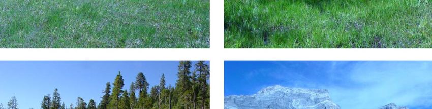
E.C. Wolf & D.J. Cooper FENS OF THE SIERRA NEVADA, CALIFORNIA, USA

Figure 1. Locations of the 79 study fens in California. Colour scale illustrates average annual precipitation
(cm). The Klamath Mountains, Cascade Range, and Sierra Nevada geomorphic provinces, and each of their
highest peaks, are indicated.

      Mires and Peat, Volume 15 (2014/15), Article 08, 1–22. http://www.mires-and-peat.net/, ISSN 1819-754X
                  © 2015 International Mire Conservation Group and International Peat Society                 3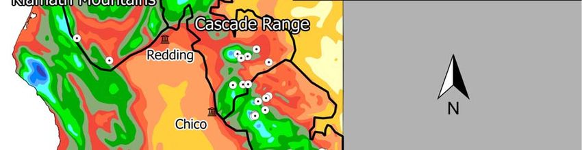
E.C. Wolf & D.J. Cooper FENS OF THE SIERRA NEVADA, CALIFORNIA, USA
environment (QGIS Development Team 2014). All              indicate clay content greater than 20 %. Therefore,
79 sites were visited between 09 July and 21               we conservatively assumed that all soils contained
September 2003. During the field visits we assigned        20 % clay. At this clay content soils require 14 %
each fen to a landform type, observed aspect azimuth       (12 + [20 * 0.1]) organic carbon, or 28 % organic
using a compass, and measured the fen surface slope        matter as determined by LOI, to be considered
using a clinometer.                                        organic soils according to the US Department of
                                                           Agriculture definition of organic soils (Soil Survey
Water                                                      Staff 1999). While this definition may suffice for soil
In the field we measured the pH of groundwater that        taxonomic purposes, there are no scientific criteria or
filled a shallow hand-dug open well. The hole was          thresholds for organic content or organic horizon
bailed and allowed to refill several times to ensure an    thickness that are known to influence the functioning
uncontaminated sample of groundwater. Sampling             of a site as a peatland (Driver 2010).
groundwater (as opposed to surface water or water
held in living moss tissue) has been found to yield the    Vegetation
most consistent measurements of environmentally-           We sampled 1–7 homogenous relevés within each
controlled site pH in fens (Tahvanainen & Tuomaala         fen, recording a total of 290 relevés within the 79
2003). We measured pH in situ using an Orion model         fens. Relevés were 4–20 m2 in area, depending upon
250A portable pH meter with combination electrode,         the size of the largest plants, the smallest relevés
which was calibrated daily with fresh pH standards.        being used for moss-dominated stands and the largest
In each fen (not each vegetation relevé) we made one       for those with shrubs and stunted trees (Mueller-
pH measurement and collected one water sample that         Dombois & Ellenberg 1974). Within each relevé a
was sealed immediately and frozen until analysis.          complete list of the plant species present was made
The water samples were analysed for electrical             and the percent canopy cover of each species was
conductance and concentrations of Ca2+, Mg2+, K+,          visually estimated by the same experienced observer.
Na+, HCO3-, CO32-, Cl-, SO42-, hardness, alkalinity           Nomenclature for vascular plants is consistent
and total dissolved solids at the Colorado State           with the Jepson Manual: Vascular Plants of
University Soil and Water Testing Laboratory.              California (Baldwin et al. 2012), and for non-
    The field data collection was spread out across an     vascular plants (mosses) with the Jepson California
entire growing season, and we expected that water          Moss eFlora (Wilson 2015) and the Flora of North
table depth measurements would not be comparable           America (Flora of North America Editorial
between sites measured early versus late in the            Committee 2015).
summer. However, water tables were within 20 cm of
the surface at all sites when visited, even during the     Data analysis
driest period of late summer 2003. Because small           The Shannon diversity index (Hill 1973) was
differences in hydrology can affect fen functioning,       calculated for each vegetation relevé but, since
it must be noted that we did not make fine-scale           diversity relies on relative abundances, we could not
hydrological measurements and, therefore, draw no          scale up the data to calculate fen-level diversity
conclusion about the effect of site hydrology on the       because the percent cover data are only relevant
study fens.                                                within each relevé. Instead, we calculated fen-level
                                                           species richness, which is a simple count of the total
Soils                                                      number of species present within all of the relevés at
In each fen we analysed soils in a hand-dug pit and        a single fen. The logarithmic relationship between
measured peat thickness by pushing a steel probe           fen-level species richness and fen area was evaluated
vertically through the soil until rock or mineral          to determine the degree to which the species-area
sediment was contacted. It has been demonstrated           relationship contributes to observed species richness
that probing is an effective method for measuring          (Gleason 1922).
peat thickness (Parsekian et al. 2012, Chimner et al.          Statistical differences in water chemistry, peat
2014). We collected one soil sample from 30–40 cm          thickness and species richness between fens with
depth and determined percent organic matter content        different categories of bedrock geology and
using loss on ignition (LOI) (Schulte & Hopkins            landforms were determined using ANOVA with
1996). For the purpose of classifying soils as organic     Tukey’s HSD multiple comparison test (R Core
we used the established estimate that approximately        Team 2014).
half of the soil organic matter is organic carbon (Ball        We evaluated the ability of 13 continuous
1964, Chimner et al. 2014). Although we did not            environmental variables to predict peat thickness and
directly measure clay content, all soils were hand-        species richness using multi-model selection. When
tested in the field and none formed ribbons that would     evaluating model fit, all possible combinations of

       Mires and Peat, Volume 15 (2014/15), Article 08, 1–22. http://www.mires-and-peat.net/, ISSN 1819-754X
                   © 2015 International Mire Conservation Group and International Peat Society                  4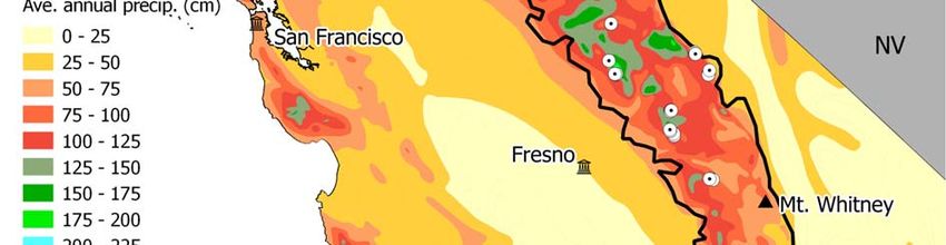
E.C. Wolf & D.J. Cooper FENS OF THE SIERRA NEVADA, CALIFORNIA, USA
explanatory environmental variables were ranked by             These same 13 variables, with species richness
AICc (Akaike’s Information Criterion, corrected for         substituted by peat thickness, were used to model
small sample size) using the glmulti and                    species richness and to generate the CCA ordination.
AICcmodavg packages in R (R Core Team 2014). All            In addition, the categorical variables of catchment
models within two points of the minimum AICc                bedrock geology (five categories) and geomorphic
model were exhaustively cross-validated (using the          landform (four categories) were converted to binary
leave-one-out technique) to determine their                 variables for use in the CCA. The five binary geology
predictive power using mean-squared-error (cv.glm           variables created were: granodiorite, metamorphic,
routine in the “boot” R package).                           volcanic, serpentine and carbonate. The four binary
    Variables were then systematically removed and          landform variables created were: (bedrock) contact,
models cross-validated to evaluate whether simpler          slope, (spring) mound and basin (see Results). Each
models would provide equivalent predictive error.           fen was assigned to one geological type and one
For estimating peat thickness or species richness on        landform type, and values of unity were assigned to
the basis of the measured environmental parameters,         the corresponding binary variables (e.g. for a sloping
the model with the smallest number of parameters            fen in a granodiorite catchment: slope = 1, all other
that provided equivalent predictive error to the            landform variables = 0; granodiorite = 1, all other
minimum AICc model was identified as the model of           geology variables = 0).
choice. This was because the datasets for some fens
were not complete and, under these circumstances,
inclusion of more parameters in the models could            RESULTS
influence the effective sample size by excluding the
fens with missing data. Therefore, we experimented          Site characteristics
with removing parameters from the minimum AICc              Fens were found throughout the Sierra Nevada, the
model to maximise sample size while including the           southern Cascade Range and southern Klamath
most important predictive variables.                        Mountains (Figure 1). The areas of the 79 fens we
    We used Detrended Correspondence Analysis               visited ranged from 45 m2 to 200,000 m2 (median
(DCA), which is an indirect ordination technique, to        1,713 m2) and their altitudes ranged from 1,207 m to
identify the overall structure of the floristic gradients   3,233 m a.s.l. (median 2,094 m). Fens occurred at
within the 290-relevé vegetation data set. The              lower altitudes in the Cascade Range, Klamath
structure in the vegetation data was analysed for           Mountains and northern Sierra Nevada than in the
correlations with environmental variables in a              southern Sierra Nevada, which is the highest-altitude
canonical correspondence analysis (CCA). Because            section of the range with relatively low annual
the environmental data were collected at the fen level,     precipitation (see Appendix).
each relevé within a fen was associated with the same           These fens had formed in four major geomorphic
set of environmental variables. To determine whether        settings, namely: at geological bedrock contacts, on
the observed CCA correlations between species and           slopes, as spring mounds, and in basins (Figure 2).
environmental data could have arisen by chance, we          Multiple landform types can occur within a single fen
conducted Monte Carlo simulations. The                      site. For example, a sloping fen may be adjacent to
environmental data were randomly reassigned to              and connected with a basin fen, and spring mounds
fens, the CCA was re-run 100 times, and correlations        can occur at the heads of sloping fens or within larger
and eigenvalues were calculated for each randomised         basin fens. When multiple landform types occurred
run. The observed values were compared with the             within a single fen complex, we observed which
Monte Carlo output to determine the probability that        mechanism was most important for maintaining the
the observed correlation between the environmental          hydrological regime of the fen and classified it
matrix and the vegetation data could have arisen by         accordingly.
chance, reported as a p-value. The program PC-Ord,              At bedrock contacts, more permeable rock (an
version 4.37, was used to perform all ordination            aquifer) overlies less permeable rock, forcing water
analyses (McCune & Mefford 1999).                           out of the ground along the contact zone. This often
    The 13 continuous environmental variables used          occurs where one lava flow lies on top of another, and
to model peat thickness were: altitude, fen slope, fen      the lower flow’s upper surface has been sealed by
aspect azimuth (sine transformed: sin(azm.+ 90) + 1),       contact with the later flow. Snowmelt water moves
soil organic matter, fen area, catchment area, average      laterally on the impermeable surface created by the
annual precipitation, soil-water pH, soil-water             discontinuity and discharges on hillslopes where the
electrical conductivity (EC), calcium concentration         contact is exposed. These spring complexes may be
(Ca), magnesium concentration (Mg), north latitude          large and produce perennial flows of water, forming
and species richness.                                       fens on steep slopes that nonetheless have thick peat

       Mires and Peat, Volume 15 (2014/15), Article 08, 1–22. http://www.mires-and-peat.net/, ISSN 1819-754X
                   © 2015 International Mire Conservation Group and International Peat Society                   5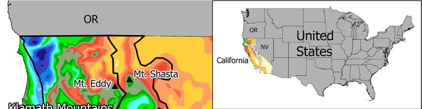
E.C. Wolf & D.J. Cooper FENS OF THE SIERRA NEVADA, CALIFORNIA, USA
bodies and well-developed fen vegetation. Eleven           ponds that infilled with partially decomposed plant
(14 %) of the 79 studied fens were classified as           remains. They are typically flat and may enclose
bedrock contact fens.                                      ponds with floating mats of peat-forming vegetation
    Fifty (63 %) of the 79 study fens had formed on        that rise and fall with the water level, thus
hillslopes where groundwater discharges to the             maintaining contact between the peat and water
surface from glacial moraines, talus, alluvium and         surfaces. This fen type is widespread and includes the
hillslope-exposed bedrock fractures. Slopes range          largest fens in the Sierra Nevada region. Sphagnum
from gentle to steep (Figure 3), and although small        teres and Sphagnum subsecundum are common
pools may occur, large areas of open water are never       species, along with the vascular plants Carex limosa,
present. Sloping fens require constant inflow of           Menyanthes trifoliata, Carex lasiocarpa and
groundwater to maintain soil saturation because            Dulichium arundinacea.
downhill drainage is relatively rapid.
    Spring mounds form at localised points of              Water chemistry
groundwater discharge that can often support only          The 79 study fens spanned a broad range of water
small fens. Many spring mound fens are only tens of        chemistry. The multi-year, multi-season, volume-
metres in diameter, but they are morphologically and       adjusted field-measured pH of precipitation across a
ecologically distinct. Spring mound fens may occur         series of measurement locations spanning the north–
at locations with strong upward groundwater                south range of the Sierra Nevada is 5.26 (National
discharge within a sloping fen complex. Five (6 %)         Atmospheric Deposition Program 2014). Only the
of the 79 fens were characterised as spring mounds         five most acidic of the 79 study fens had pH values
with upwelling groundwater.                                below 5.26, indicating the predominance of
    The remaining 13 (16 %) of the 79 fens were in         groundwater processes that raise the pH of rainwater
basins. Basin fens probably originated as lakes or         as it moves through an aquifer. Using the well-

 Figure 2. The four major landform types identified amongst the Sierra Nevada fens. A = bedrock contact
 (fed by seepage from the contact zone between an aquifer and an underlying layer of less permeable rock),
 B = slope, C = spring mound (formed at a groundwater discharge site), and D = basin. The arrows indicate
 directions of groundwater and/or surface water flow.

       Mires and Peat, Volume 15 (2014/15), Article 08, 1–22. http://www.mires-and-peat.net/, ISSN 1819-754X
                   © 2015 International Mire Conservation Group and International Peat Society                 6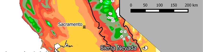
E.C. Wolf & D.J. Cooper FENS OF THE SIERRA NEVADA, CALIFORNIA, USA

                                                                                                        Figure 3. Four fens in the study
                                                                                                        region:

                                                                                                        (top left) gently sloping fen
                                                                                                        dominated by the spike-sedge
                                                                                                        Eleocharis quinqueflora;

                                                                                                        (top right) fen with high cover
                                                                                                        of Pinus contorta and shrubs;

                                                                                                        (bottom left) steeply sloping
                                                                                                        fen with the pitcher plant
                                                                                                        Darlingtonia californica in the
                                                                                                        foreground;

                                                                                                        (bottom right) Convict Creek
                                                                                                        basin, which is the only region
                                                                                                        with limestone/marble in the
                                                                                                        Sierra Nevada, showing fen
                                                                                                        dominated by the sedge
                                                                                                        Kobresia myosuroides.

Mires and Peat, Volume 15 (2014/15), Article 08, 1–22. http://www.mires-and-peat.net/, ISSN 1819-754X
            © 2015 International Mire Conservation Group and International Peat Society                                                7
E.C. Wolf & D.J. Cooper FENS OF THE SIERRA NEVADA, CALIFORNIA, USA
established poor–rich gradient terminology (Sjörs          bedrock.
1950, Cooper & Andrus 1994, Lemly & Cooper                    Bedrock lithology strongly influenced fen water
2011), the fens in the study area ranged from              chemistry. Fens on granodiorite and undifferentiated
transitional (intermediate between poor and rich) to       metamorphic bedrock (metamorphics other than
extremely rich, based on their pH and cation               serpentine and carbonate marble) had significantly
concentrations (Figure 4). Of the 27 transitional fens,    lower concentrations of calcium, lower EC, and were
four had metamorphic bedrock, one had volcanic             more acidic than fens on other rock types (Figure 5).
bedrock, and 22 were in catchments dominated by            The two carbonate fens had significantly higher EC
granodiorite. The lowest pH value (4.3) was found at       and levels of calcium, and were more basic than other
a floating mat in Willow Lake, within a volcanic           fens. The one serpentine fen we visited contained
bedrock catchment. Low concentrations of dissolved         groundwater with markedly elevated levels of
ions in the Willow Lake sample, along with high            magnesium.
Sphagnum moss cover, suggest that the acidity is
generated by the moss rather than by geochemical           Peat
weathering by-products. The highest pH values (7.5         The peat layer in sampled fens averaged 83 cm thick,
and 8.0) were found at two fens in the Convict Creek       ranging from as thin as 15 cm to a maximum of
basin (Figure 3), where carbonate rocks (primarily         253 cm. The fens with the largest catchment areas
marble, and some calcareous hornfels) are exposed          typically contained the thickest peat, but this
(Major & Bamberg 1963). High concentrations of             relationship included considerable scatter in larger
calcium and carbonate in water at the Convict Creek        catchments, where peat ranged from thick to thin
sites confirms that the high pH is a result of             (Figure 6A). The positive linear correlation between
geochemical weathering of the marble and hornfels          peat thickness and catchment area was statistically

 Figure 4. Classification of fens by pH and cation concentration. The bedrock geology of each fen’s
 catchment is indicated by symbol shape and colour.

       Mires and Peat, Volume 15 (2014/15), Article 08, 1–22. http://www.mires-and-peat.net/, ISSN 1819-754X
                   © 2015 International Mire Conservation Group and International Peat Society                 8
E.C. Wolf & D.J. Cooper FENS OF THE SIERRA NEVADA, CALIFORNIA, USA
significant (p = 0.0163) but explained only 7 % of the thickness and catchment area, an increase in slope
variation in the data (R2adj = 0.06652). The reduced the maximum peat thickness attained (see
regression was less significant (p = 0.0818) when dashed line in Figure 6B).
catchment area was log transformed and compared to The organic matter content of the sampled peat
peat thickness, but the log-transformation allows for averaged 57 % and was above the 28 % organic
better visual assessment of the pattern of increasing matter threshold for organic soils (see Methods) in
maximum peat thickness in larger catchments (see 91 % of the samples. Twenty-two percent of the
dashed line in Figure 6A). samples contained more than 80 % organic matter.
Peat thickness was negatively correlated with fen The fens with the thickest peat tended to have the
slope; fens on steeper slopes generally had thinner highest organic matter content (P = 0.0015), and this
peat layers (Figure 6B). Although this was a correlation accounted for 14 % (R2adj = 0.1381) of the
statistically significant regression (P = 0.0134), fen variation in peat organic matter content (Figure 6C).
slope only explained about 7 % of the variation in The evaluation of 13 environmental variables in
peat thickness (R2adj = 0.0711). Peat thickness varied models of peat thickness produced a minimum AICc
widely in gently sloping fens, whereas its range was model involving six environmental variables, namely
restricted to relatively low values in more steeply percent soil organic matter (OM), catchment area, fen
sloping fens. As with the relationship between peat area, aspect (sine transformed), pH and EC. Cross
Figure 5. The pH, electrical conductivity, calcium and magnesium concentrations of groundwater in fen
catchments dominated by granodiorite, metamorphic, volcanic, serpentine and carbonate rocks. N = number
of fens in each category. Letters indicate significant differences determined by ANOVA with Tukey’s HSD
multiple comparison test.
Mires and Peat, Volume 15 (2014/15), Article 08, 1–22. http://www.mires-and-peat.net/, ISSN 1819-754X
© 2015 International Mire Conservation Group and International Peat Society 9E.C. Wolf & D.J. Cooper FENS OF THE SIERRA NEVADA, CALIFORNIA, USA
validation of the six-parameter minimum AICc peat-thickness prediction error of ± 44.9 cm. The
model indicated a prediction error of ± 49.8 cm of peat-thickness prediction interval for this three-
peat. By evaluating nearly-equivalent models and parameter model was 90 cm, and slightly more than
testing variable-removal effects on prediction error, one-third of the total observed peat thickness range
we arrived at a three-parameter model using OM (%), of 238 cm. The three-parameter model, with
catchment area (ha) and fen area (ha) which had a R2adj = 0.2991, is:
(peat thickness, cm) = 0.8523*(OM) + 0.1190*(catchment area) + 5.3076*(fen area) + 21.6950 [1]
Figure 6. The relationships of peat thickness with catchment area, fen slope and soil organic content. Panel
A shows peat thickness as a function of fen catchment area (note log scale). Catchment area has been log
transformed to highlight (with a visually fitted dashed line) the increase in maximum peat thickness as
catchment area increases. Panel B shows peat thickness versus slope. The thickest peat bodies occur on the
gentlest slopes, and few peat bodies exceed 1 m thickness on slopes steeper than 15 %. A visually-fitted line
(dashed) shows maximum peat thickness decreasing as slope increases. Panel C illustrates that thicker peat
bodies have higher organic matter content. The linear regression line is shown (P = 0.0015) and explains
14 % of the variation in the data (y = 0.8461x + 36.1937, R2adj = 0.1381). The bedrock geology of each fen’s
catchment is indicated by symbol shape and colour. The single serpentine site is not shown because it is
missing peat thickness data.
Mires and Peat, Volume 15 (2014/15), Article 08, 1–22. http://www.mires-and-peat.net/, ISSN 1819-754X
© 2015 International Mire Conservation Group and International Peat Society 10E.C. Wolf & D.J. Cooper FENS OF THE SIERRA NEVADA, CALIFORNIA, USA
Vegetation prediction window for fen species richness is 12.94
In total, 170 vascular plant and bryophyte species species wide, which is 32 % of the entire 40-species
were identified in the 290 relevés recorded at the 79 range in richness. This model has an R2adj = 0.2894
study fens. The relevé-level Shannon diversity index and is able to predict which one-third of the species
ranged from zero (one species) to 2.443 (20 species) richness (SR) range a given fen will fall into, based
across 290 relevés. Relevé-level richness ranged on altitude only. Multi-parameter model selection
from one to 23 species. Scaled up to the fen level, using the full set of 13 environmental variables
species richness ranged from two to 42 species. The arrived at an optimal four-parameter model with an
relationship between log10 (fen area) and species AICc of 407. The four variables selected were
richness had a p-value of 0.0542 and fen area altitude (m), fen slope (%), peat thickness (cm) and
explained about 4 % (R2adj = 0.03839) of the variation OM (%). This four-parameter model has a cross-
in species richness. Altitude alone explained validated prediction error of ± 5.78 species, yielding
approximately 29 % (R2adj = 0.2894) of the variation a prediction window 11.56 species wide. The
in species richness between fens (Figure 7). window spans 29 % of the entire 40-species range in
The single-parameter altitude model had an AICc richness, a 3 % improvement over the altitude-only
of 501 and a cross-validated prediction error of model. The four-parameter model has R2adj = 0.5121,
± 6.47 species. Therefore, using altitude alone, the and is as follows:
SR = -0.0072*(altitude) + 0.3488*(fen slope) + 0.1041*(OM) + 0.0399*(peat thickness) + 22.7314 [2]
Figure 7. The relationship between species richness and altitude. Each fen’s catchment bedrock geology is
indicated by symbol shape and colour. Fen plant species richness decreases with altitude (pE.C. Wolf & D.J. Cooper FENS OF THE SIERRA NEVADA, CALIFORNIA, USA
Indirect ordination using DCA (Figure 8) the sites by 8 SD units (Figure 9, inset) is the main
illustrates the complex floristic gradients in the pattern in the combined vegetation-environment
vegetation dataset. The two primary ordination axes CCA ordination. To further explore the
shown are scaled in standard deviation (SD) units. A environmental gradients within the main group of
4-SD distance between relevés along either axis data, the two carbonate fens were removed because
represents almost no overlap in species composition their distinct flora, structured by a unique rock type
(McCune & Mefford 1999). The DCA of all 290 and water with very high calcium content,
relevés (inset, Figure 8) is roughly separated into overshadowed the influence of other variables on the
three distinct vegetation groups. Relevés from two rest of the data.
volcanic bedrock fens in the Lassen National Forest Leaving out the two carbonate fens and running a
(Willow Lake and Domingo Lake) occur on the right CCA ordination on the remaining 77 sites produced
side of Axis 1, about 3–4 SD units from a vertically- a much more even spread of data in the ordination
oriented mass containing most of the relevés. These space (Figure 9, main panel). The sites that had been
are basin fens with floating mats dominated by the farthest outliers in the DCA (vegetation data
Carex lasiocarpa, Carex vesicaria, Dulichium only), Willow Lake and Domingo Lake with unique
arundinaceum, Menyanthes trifoliata and occurrences of Dulichium arundinaceum and
Utricularia macrorhiza. The vegetation from the Scheuchzeria palustris, plot in the lower middle of
relevés in two extremely rich carbonate bedrock fens the ordination space but are contiguous with the rest
in the Inyo National Forest (Hanging Fen and of the data. Four environmental variables were
Mildred Lake) is made up of Trichophorum pumilum, correlated (R2 > 0.24) with the structure in the 77-fen
Kobresia myosuroides, Thalictrum alpinum and ordination, namely pH, altitude, fen slope and
others. These species occur about 0.5 SD units left- membership of the volcanic bedrock class. The
of-centre of the central mass of relevés. In other orientations of these correlations are indicated by the
words, the primary (Axis 1, Figure 8 inset) pattern in red arrows on the CCA (Figure 9).
the vegetation data is driven by the distinct flora of The main pattern in the vegetation data, along
the outlier fens, with the two volcanic sites to the Axis 1, is a separation of species by the dominant
right and the two carbonate sites to the left. rock type in the catchment and the pH of the fen
Removing the 17 outlier relevés that represent the water. Species and fens associated with volcanic
two carbonate and two volcanic fens allowed an bedrock and higher pH are to the left of the
analysis of the vegetation patterns in the absence of ordination, granodiorite and mid-pH species and fens
the sites with unique vegetation that dominate the are central, and metamorphic and acidic plants and
DCA. The 273-relevé DCA with outliers removed sites lie to the right. Although the lone serpentine fen
(Figure 8, main panel) shows a fairly continuous is classified as extremely rich due to its high pH and
vegetation gradient within the main group of relevés. cation concentration (Figure 4), its vegetation is
The environmental variable that correlated most most similar to that of acidic metamorphic sites
strongly with the purely vegetation-derived patterns with species like Rhododendron columbianum,
in the DCA was pH, with an R2 of 0.2079 with respect Narthecium californicum, Darlingtonia californica
to Axis 1. All other environmental variables had and Carex echinata. The Sphagnum moss species
R2 < 0.1110. At the extreme right of Axis 1 are fens plot in the middle-right, in the moderately acidic
dominated by trees, shrubs and Sphagnum (Pinus region dominated by granodiorite sites.
contorta, Rhododendron columbianum, Lonicera A secondary pattern in the CCA, along Axis 2, is
cauriana, Kalmia polifolia, Vaccinium uliginosum, the separation of species on steeply sloping sites from
Rhynchospora alba, Sphagnum teres and Sphagnum those in flat valleys and basins. The major outlier
subsecundum) (Figure 3). At the opposite (left) end species in the vegetation-only DCA (Figure 8, inset),
of Axis 1, correlated with basic pH conditions, are which are unique to the Willow Lake and Domingo
relevés dominated by several species of Carex, Lake fens, occur in basin fens with no slope and plot
Scirpus microcarpus and Calamagrostis canadensis at the bottom of the ordination. None of the measured
with the brown mosses Drepanocladus sordidus, environmental variables show a major difference
Drepanocladus longifolius and Meesia triquetra. between the Willow and Domingo fens and the rest
The explicit inclusion of the environmental data of the dataset; they fit in with the broader trends of
into the ordination of vegetation data at the fen level, the CCA gradients, albeit at the edge. This is in sharp
in a CCA, highlights the unique flora at the carbonate contrast to the carbonate sites, whose distinct
sites. In the CCA of all 79 fens, by far the strongest vegetation is correlated with unique bedrock geology
gradient along Axis 1 is membership of the carbonate and extreme water chemistry values. A significant
bedrock class, followed by calcium concentration. altitude gradient is correlated with both axes, with
The segregation of the carbonate fens from the rest of high-altitude sites plotting in the upper left and low-
Mires and Peat, Volume 15 (2014/15), Article 08, 1–22. http://www.mires-and-peat.net/, ISSN 1819-754X
© 2015 International Mire Conservation Group and International Peat Society 12E.C. Wolf & D.J. Cooper FENS OF THE SIERRA NEVADA, CALIFORNIA, USA
Figure 8. Detrended correspondence analysis (DCA) of the vegetation at 273 fen relevés. The DCA of all
290 relevés is shown inset, and indicates that the relevés from the two carbonate fens (blue squares, circled
on left) and two volcanic fens (pink triangles, circled on right) are outliers that dominate the structure of the
full dataset. Species names show relative species positions (unlabelled species appear as small black dots);
coloured shapes show relative relevé positions, coded by catchment geology. Axes are scaled in standard
deviation (SD) units. Complete species turnover occurs at a distance of ~4 SD. Axis 1 is a vegetation gradient
that correlates with pH (overlaid red arrow indicates direction of increasing pH, R2 = 0.21). Selected species
abbreviations are: Aulpal = Aulacomnium palustre; Calcan = Calamagrostis canadensis; Camqua =
Camassia quamash; Camste = Campylium stellatum; Carcap = Carex capitata; Carech = Carex echinata;
Carlas = Carex lasiocarpa; Carlen = Carex lenticularis; Carlim = Carex limosa; Carluz = Carex luzulina;
Carneb = Carex nebrascensis; Carpel = Carex pellita; Carsco = Carex scopulorum; Carsim = Carex
simulata; Carutr = Carex utriculata; Carves = Carex vesicaria; Darcal = Darlingtonia californica;
Desces = Deschampsia cespitosa; Dreadu = Drepanocladus aduncus; Drelon = Drepanocladus longifolius;
Dresor = Drepanocladus sordidus; Droang = Drosera anglica; Drorot = Drosera rotundifolia; Elemac =
Eleocharis macrostachya; Elequi = Eleocharis quinqueflora; Ericri = Eriophorum criniger; Hypana =
Hypericum anagalloides; Junbal = Juncus balticus; Junens = Juncus ensifolius; Junnev = Juncus
nevadensis; Junoxy = Juncus oxymeris; Kalpol = Kalmia polifolia; Loncau = Lonicera cauriana; Meetri =
Meesia triquetra; Mentri = Menyanthes trifoliata; Mimpri = Mimulus primuloides; Narcal = Narthecium
californicum; Orealp = Oreostemma alpigenum; Oxyocc = Oxypolis occidentalis; Phabol = Phalacroseris
bolanderi; Phifon = Philonotis fontana; Pincon = Pinus contorta; Polbis = Polygonum bistortoides;
Ptybim = Ptychostomum bimum; Ptypse = Ptychostomum pseudotriquetra; Rhocol = Rhododendron
columbianum; Rhyalb = Rhynchospora alba; Scimic = Scirpus microcarpus; Sphsub = Sphagnum
subsecundum; Sphter = Sphagnum teres; Triocc = Triantha occidentalis subsp. occidentalis; Utrint =
Utricularia intermedia; Utrmac = Utricularia macrorhiza; Vaculi = Vaccinium uliginosum.
Mires and Peat, Volume 15 (2014/15), Article 08, 1–22. http://www.mires-and-peat.net/, ISSN 1819-754X
© 2015 International Mire Conservation Group and International Peat Society 13E.C. Wolf & D.J. Cooper FENS OF THE SIERRA NEVADA, CALIFORNIA, USA
Figure 9. Canonical correspondence analysis (CCA) of the vegetation and environmental variables at 77
study fens, excluding the two carbonate fens. The CCA of all 79 fens is shown inset, indicating that the
carbonate fens (blue squares, circled on left) are extreme outliers. Catchment geology is denoted by point
shape and colour. Significant environmental factors (R2 > 0.24) are shown as red vectors, the value of the
factor increasing in the direction indicated by the arrow. Unlabelled species appear as small black dots in
the ordination, and selected species abbreviations are: Aulpal = Aulacomnium palustre;
Calcan = Calamagrostis canadensis; Camqua = Camassia quamash; Camste = Campylium stellatum;
Carcap = Carex capitata; Carech = Carex echinata; Carlas = Carex lasiocarpa; Carlen = Carex lenticularis;
Carlim = Carex limosa; Carluz = Carex luzulina; Carneb = Carex nebrascensis; Carpel = Carex pellita;
Carsco = Carex scopulorum; Carsim = Carex simulata; Carutr = Carex utriculata; Carves = Carex
vesicaria; Darcal = Darlingtonia californica; Desces = Deschampsia cespitosa; Dreadu = Drepanocladus
aduncus; Drelon = Drepanocladus longifolius; Dresor = Drepanocladus sordidus; Droang = Drosera
anglica; Drorot = Drosera rotundifolia; Dularu = Dulichium arundinaceum; Elemac = Eleocharis
macrostachya; Elequi = Eleocharis quinqueflora; Ericri = Eriophorum criniger; Hypana = Hypericum
anagalloides; Junbal = Juncus balticus; Junens = Juncus ensifolius; Junnev = Juncus nevadensis; Junoxy =
Juncus oxymeris; Kalpol = Kalmia polifolia; Kobmyo = Kobresia myosuroides; Loncau = Lonicera
cauriana; Meetri = Meesia triquetra; Mentri = Menyanthes trifoliata; Mimpri = Mimulus primuloides;
Narcal = Narthecium californicum; Orealp = Oreostemma alpigenum; Oxyocc = Oxypolis occidentalis;
Phabol = Phalacroseris bolanderi; Phifon = Philonotis fontana; Pincon = Pinus contorta;
Polbis = Polygonum bistortoides; Ptybim = Ptychostomum bimum; Ptypse = Ptychostomum
pseudotriquetra; Rhocol = Rhododendron columbianum; Rhyalb = Rhynchospora alba; Schpal =
Scheuchzeria palustris; Scimic = Scirpus microcarpus; Sphsub = Sphagnum subsecundum; Sphter =
Sphagnum teres; Triocc = Triantha occidentalis subsp. occidentalis; Utrint = Utricularia intermedia;
Utrmac = Utricularia macrorhiza; Vaculi = Vaccinium uliginosum.
Mires and Peat, Volume 15 (2014/15), Article 08, 1–22. http://www.mires-and-peat.net/, ISSN 1819-754X
© 2015 International Mire Conservation Group and International Peat Society 14E.C. Wolf & D.J. Cooper FENS OF THE SIERRA NEVADA, CALIFORNIA, USA
altitude sites in the lower right. The total inertia mountain landscapes and have the potential to
(variance) in the CCA is 10.25, and the Axis 1 increase sedimentation to fens and impact peatland
eigenvalue (the amount of variance explained) is ecological processes.
0.542, or 5.3 % of the total variance. The Axis 2 Because peatlands are formed and maintained
eigenvalue is 0.454, explaining a further 3.8 % of the through primary production of organic matter by
variance, making a combined two-axis total of 9.7 %. wetland plants, understanding the environmental
The Monte Carlo test showed that the correlation drivers of plant diversity and distribution is critical to
between the environmental matrix and the vegetation the study of peatland function. Altitude exerts strong
data is significant (P = 0.03). control over fen-level species richness and
distribution. The most species-rich fens occur at
lower altitudes. This altitude effect is probably due to
a longer snow-free growing season and warmer
DISCUSSION temperatures at the lower sites. However, the lower-
altitude sites also tend to occur in the northern Sierras
The broad patterns of physical and biological where more precipitation falls, so it is also possible
processes that control fen distribution and diversity that the trend in species richness could be related to a
in the Sierra Nevada are relevant to the study of hydrological gradient that we did not measure
mountain peatlands throughout the world. The higher directly within the fens, or a regional species pool
annual precipitation in the northern portion of the effect.
study area allows the development of groundwater The reduction of species richness with increasing
flow systems that are sufficient to support fens at altitude is a well-known ecological relationship that
lower altitudes. By contrast, in the drier southern part applies to many taxa and mountain ranges throughout
of the Sierra Nevada, fens can form only under the the world (Rahbek 1995, Grytnes 2003, Bruun et al.
cooler conditions at high altitudes. Because the 2006). Mountain peatlands provide an interesting
northern Sierra Nevada contains little high-altitude venue for exploring this relationship because many of
landscape, there are few opportunities for fens to the key ecosystem processes (e.g. hydrology, peat
occupy this zone. In the southern Sierra Nevada the formation and water chemistry) that are thought to
most likely reason for the lack of low-altitude fens is limit plant growth and survival in fens are not
a combination of low precipitation and warm necessarily affected by changes in altitude. This
temperatures creating high evapotranspiration study was not designed to address this question
demand. However, fens occur in the semi-arid explicitly, but the pattern of decreasing richness with
mountains of northern Chile, where annual increasing altitude is significant nonetheless.
precipitation rarely exceeds 25 cm (Squeo et al. Furthermore, the pattern of richness is not a function
2006), further illustrating the overwhelming of larger fens having more species due to a species-
importance of groundwater flow paths for the area effect. Targeted investigations into the specific
maintenance of saturated soil conditions and peat drivers of the richness-altitude pattern within
formation. mountain peatlands would help tease apart the
In addition to providing insights about the various contributing environmental factors.
locations and landscapes where mountains fens form, Water chemistry, particularly calcium
the relationships between peat thickness and concentration and pH, created the largest distinctions
catchment area, fen slope and organic matter content in fen species composition. The two carbonate fens,
have implications for the vulnerability of mountain which had many unique species, high calcium
fens to future climate changes, including severe concentrations and high pH, were the main drivers of
droughts. Most fens in small catchments have thin this primary structure in our dataset. After removing
peat, perhaps due to a lower volume of local the outlier fens on carbonate bedrock, water pH was
groundwater aquifers that may become depleted one of the strongest drivers of plant distribution in our
during periodic droughts, limiting peat accumulation. CCA analyses. This is well known from previous
The variable that is most strongly correlated with peat studies that have shown pH and the poor-rich
thickness is organic matter content. While it is not gradient to be primary factors in determining fen
suggested that the relationship is causative in either vegetation (Sjörs 1950, Vitt et al. 1995, Chapin et al.
direction, it stands to reason that both thickness and 2004).
organic content of peat would be similarly influenced The fens of the marble regions of the Inyo
by other processes such as mineral sediment input, National Forest are unique on the west coast of the
decomposition rates and primary production rates. USA from a floristic, ecological and biogeographical
Wildfires, road construction and maintenance, and perspective (Major & Bamberg 1963). The
logging all occur frequently in National Forest dominance of calciphiles including Kobresia
Mires and Peat, Volume 15 (2014/15), Article 08, 1–22. http://www.mires-and-peat.net/, ISSN 1819-754X
© 2015 International Mire Conservation Group and International Peat Society 15E.C. Wolf & D.J. Cooper FENS OF THE SIERRA NEVADA, CALIFORNIA, USA
myosuroides, Trichophorum pumilum and Carex ACKNOWLEDGEMENTS
scirpoidea is striking, and other extremely rich fens
in the region should be more carefully investigated, This research was funded by the United States Forest
as they have been in the Rocky Mountains and Service, Region 5. We especially thank all of the
Canada (Vitt & Chee 1990, Cooper 1996). An Forest Botanists for providing the resources to assist
example of this fen type is shown in Figure 3 (bottom us in locating likely fens across the vast mountain
right). In addition, the presence of communities landscapes of California.
similar to those in maritime coastal areas and
dominated by Narthecium californicum should also
be more thoroughly investigated. There are relatively
few reports of fens in North America dominated by REFERENCES
species other than mosses or Cyperaceae, and peat
formed by a species belonging to the Liliaceae is Allen-Diaz, B.H. (1991) Water table and plant
unusual. A community dominated by Narthecium species relationships in Sierra Nevada meadows.
ossifragum and Sphagnum tenellum occurs in Britain, American Midland Naturalist, 126, 30–43.
in what are characterised as oligotrophic flushes, or Anderson, R. & Smith, S. (1994) Paleoclimatic
springs, in highly acidic rocks (McVean & Ratcliffe interpretations of meadow sediment and pollen
1962). However, the lily-dominated California fens stratigraphies from California. Geology, 22, 723–
are not highly acidic. 726.
The highly distinct vegetation and acidic Baker, H. (1972) A fen on the northern California
conditions approaching poor-fen status at the Willow coast. Madroño, 21, 405–416.
and Domingo Lake sites is unique in the study region Baldwin, B.G., Goldman, D.H., Keil, D.J., Patterson,
and deserves further investigation. In addition, more R., Rosatti, T.J. & Wilken, D.H. (eds.) (2012) The
fens on serpentine bedrock should be examined. It is Jepson Manual: Vascular Plants of California.
well known that the high levels of magnesium and Second edition, University of California Press,
other toxic elements in serpentine soils and bedrock Berkeley, California, 1568 pp.
have profound effects on associated ecosystems Ball, D. (1964) Loss-on-ignition as an estimate of
(Harrison & Rajakaruna 2011). It is interesting that organic matter and organic carbon in non-
the environmental variables measured in this study calcareous soils. Journal of Soil Science, 15, 84–
highlighted the distinct vegetation of the carbonate 92.
sites, while the unique flora of the highly acidic sites Barbour, M. (1988) California upland forests and
was not strongly differentiated in the CCA analysis. woodlands. In: Barbour, M. & Billings, W. (eds.)
This is almost certainly due to the fact that the two North American Terrestrial Vegetation,
carbonate sites were the only examples of sites Cambridge University Press, Cambridge, UK,
associated with that bedrock type that we studied, 161–202.
whereas we sampled at a number of other volcanic- Bartolome, J.W., Erman, D.C. & Schwarz, C.F.
bedrock sites in addition to the uniquely-vegetated (1990) Stability and Change in Minerotrophic
Willow and Domingo Lake sites. Peatlands, Sierra Nevada of California and
The past and present influence of pack stock Nevada. Research Paper PSW-198, U.S.
(horses) and livestock (primarily cattle and sheep) on Department of Agriculture, Forest Service,
fens is a critical scientific and resource management Pacific Southwest Forest and Range Experiment
question. Many fens that are not presently used for Station, Berkeley, California, 11 pp.
pasture were heavily grazed in the 19th century and Bedford, B.L. & Godwin, K.S. (2003) Fens of the
may not have recovered (Dull 1999), due to United States: Distribution, characteristics, and
threshold-crossing impacts such as erosion gully scientific connection versus legal isolation.
formation and loss of soil organic matter. While there Wetlands, 23, 608–629.
is considerable interest in current pack stock and Beguin, C. & Major, J. (1975) Contribution à l’étude
livestock use, the effects of current use may be phytosociologique et écologique des marais de la
additive to historical grazing impacts. Continued Sierra Nevada (Californie) (Contribution to the
research on past and present impacts to fens is clearly phytosociological and ecological study of the
needed to inform restoration efforts, which should be wetlands of the Sierra Nevada (California)).
a top priority for land managers and include the Phytocoenologia, 2, 349–367.
removal of hydrological modifications, road and Bragg, O., Lindsay, R., Risager, M., Silvius, M. &
stock impacts, and the re-introduction of local Zingstra, H. (eds.) (2003) Strategy and Action
genotypes of fen-dominant species to sites from Plan for Mire and Peatland Conservation in
which they have now disappeared. Central Europe. Publ. No. 18, Wetlands
Mires and Peat, Volume 15 (2014/15), Article 08, 1–22. http://www.mires-and-peat.net/, ISSN 1819-754X
© 2015 International Mire Conservation Group and International Peat Society 16E.C. Wolf & D.J. Cooper FENS OF THE SIERRA NEVADA, CALIFORNIA, USA
International, Wageningen, 93 pp. Online at: Dull, R. (1999) Palynological evidence for 19th
http://www. wetlands.org/pubs&/CEPP.htm. century grazing-induced vegetation change in the
Bruun, H.H., Moen, J., Virtanen, R., Grytnes, J.-A., southern Sierra Nevada, California, USA. Journal
Oksanen, L. & Angerbjörn, A. (2006) Effects of of Biogeography, 26, 899–912.
altitude and topography on species richness of Erman, D., Roby, K. & Eames, M. (1977)
vascular plants, bryophytes and lichens in alpine Hydrological features of a California coastal fen.
communities. Journal of Vegetation Science, 17, The Great Basin Naturalist, 37, 57–66.
37–46. Fites-Kaufman, J.A., Rundel, P.W., Stephenson, N.L.
Burke, M. (1991) Establishment Record for Grass & Weixelman, D. (2007) Montane and subalpine
Lake Research Natural Area, Lake Tahoe Basin vegetation of the Sierra Nevada and Cascade
Management Unit, El Dorado County, California. Ranges. In: Barbour, M.G., Keeler-Wolf, T. &
Report to the U.S. Department of Agriculture Schoenherr, A.A. (eds.) Terrestrial Vegetation of
Forest Service , 60 pp. California, third edition, University of California
Chadde, S.W., Shelly, J.S., Bursik, R.J., Moseley, Press, Berkeley, California, 456–501.
R.K., Evenden, A.G., Mantas, M., Rabe, F. & Flora of North America Editorial Committee (eds.)
Heidel, B. (1998) Peatlands on National Forests (2015) Flora of North America, North of Mexico.
of the Northern Rocky Mountains: Ecology and Missouri Botanical Gaardens, St. Louis, MO, 20+
Conservation. General Technical Report RMRS- volumes. Online at: http://floranorthamerica.org,
GTR-11, U.S. Department of Agriculture, Forest accessed 09 Jan 2015.
Service, Rocky Mountain Research Station, Gleason, H. (1922) On the relation between species
Ogden, Utah, 75 pp. and area. Ecology, 3, 158–162.
Chapin, C.T., Bridgham, S.D. & Pastor, J. (2004) pH Grytnes, J. (2003) Species richness patterns of
and nutrient effects on above-ground net primary vascular plants along seven altitudinal transects in
production in a Minnesota, USA bog and fen. Norway. Ecography, 3, 291–300.
Wetlands, 24, 186–201. Harrison, S. & Rajakaruna, N. (2011) Serpentine:
Chimner, R.A., Lemly, J.M. & Cooper, D.J. (2010) The Evolution and Ecology of a Model System.
Mountain fen distribution, types and restoration University of California Press, Berkeley, 464 pp.
priorities, San Juan Mountains, Colorado, USA. Heidel, B. & Rodemaker, E. (2008) Inventory of
Wetlands, 30, 763–771. Peatland Systems in the Beartooth Mountains,
Chimner, R.A., Ott, C.A., Perry, C.H. & Kolka, R.K. Shoshone National Forest, Park County,
(2014) Developing and evaluating rapid field Wyoming. Prepared for: Evironmental Protection
methods to estimate peat carbon. Wetlands, 34, Agency, Wyoming Natural Diversity Database,
1241–1246. Laramie, WY 82071, 43 pp.
Cooper, D.J. (1996) Water and soil chemistry, Hill, M. (1973) Diversity and evenness: a unifying
floristics, and phyosociology of the extreme rich notation and its consequences. Ecology, 54, 427–
High Creek fen, in South Park, Colorado, U.S.A. 432.
Canadian Journal of Botany, 74, 1801–1811. Holmquist, J.G., Jones, J.R., Schmidt-Gengenbach,
Cooper, D. & Andrus, R. (1994) Patterns of J., Pierotti, L.F. & Love, J.P. (2011) Terrestrial
vegetation and water chemistry in peatlands of the and aquatic macroinvertebrate assemblages as a
west-central Wind River Range, Wyoming, USA. function of wetland type across a mountain
Canadian Journal of Botany, 72, 1586–1597. landscape. Arctic Antarctic and Alpine Research,
Cooper, D.J., Chimner, R.A. & Merritt, D.M. (2012) 43, 568–584.
Mountain wetlands of North America. In: Batzer, Hope, G., Nanson, R. & Jones, P. (2012) Peat-
D. & Baldwin, A. (eds.) Wetland Habitats of Forming Bogs and Fens of the Snowy Mountains
North America: Ecology and Conservation of NSW. Office of Environment & Heritage,
Concerns, University of California Press, Sydney, Australia, 82 pp.
Berkeley, USA, 313–328. Hopkinson, P., Hammond, M., Bartolome, J.,
Cooper, D.J., Wolf, E.C., Ronayne, M.J. & Roche, Brooks, M., Berlow, E.L., Klinger, R., Matchet,
J.W. (2015) Effects of groundwater pumping on J.R., Moore, P., Ostoja, S., Soulard, C., Joppa, L.,
the sustainability of a mountain wetland complex, Williams, R., Alvarez, O., Guo, Q., Haultain, S.,
Yosemite National Park, California. Journal of Frenzel, E. & Saah, D. (2013) A Natural Resource
Hydrology: Regional Studies, 3, 87–105. Condition Assessment for Sequoia and Kings
Driver, K. (2010) Distinguishing the hydrologic Canyon National Parks Appendix 13 - Meadows.
regimes and vegetation of fens and wet meadows Natural Resource Report NPS/SEKI/NRR-
in the Rocky Mountains. Masters thesis, Colorado 2013/665.13, National Park Service, Fort Collins,
State University, Fort Collins, Colorado, 81 pp. Colorado, 103 pp.
Mires and Peat, Volume 15 (2014/15), Article 08, 1–22. http://www.mires-and-peat.net/, ISSN 1819-754X
© 2015 International Mire Conservation Group and International Peat Society 17You can also read