Routes4U Feasibility Study on an Iron Age cultural route in the Danube Region - Council of Europe
←
→
Page content transcription
If your browser does not render page correctly, please read the page content below
Routes4U Project Feasibility Study on the Roman Heritage Route in the Adriatic and Ionian
Region
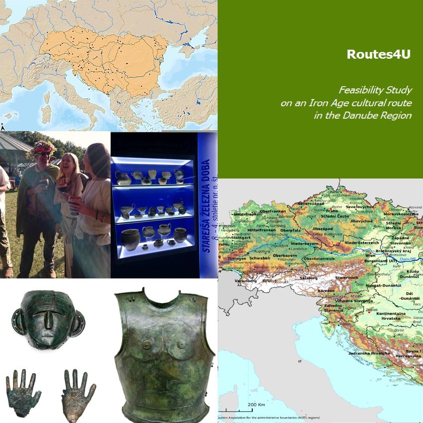
Routes4U
Feasibility Study
on an Iron Age cultural route
in the Danube Region
Routes4U Project
Routes4U Feasibility study on an Iron Age cultural route in the Danube Region

                                                                                         ROUTES4U

             FEASIBILITY STUDY ON AN IRON AGE CULTURAL
                            ROUTE IN THE DANUBE REGION

                                                                                                 August 2019

  The present study has been developed in the framework of Routes4U, the Joint Programme between the Council
  of Europe and the European Commission (DG REGIO). Routes4U aims to foster regional development through
  the Cultural Routes of the Council of Europe programme in the four EU macro-regions: the Adriatic and Ionian,
  Alpine, Baltic Sea and Danube Regions. A special thank you goes to the author Martin Fera, and to the numerous
  partners and stakeholders who supported the study. The opinions expressed in this work are the responsibility of
  the author and do not necessarily reflect the official policy of the Council of Europe.

www.coe.int/routes4u                                                                                        2 / 57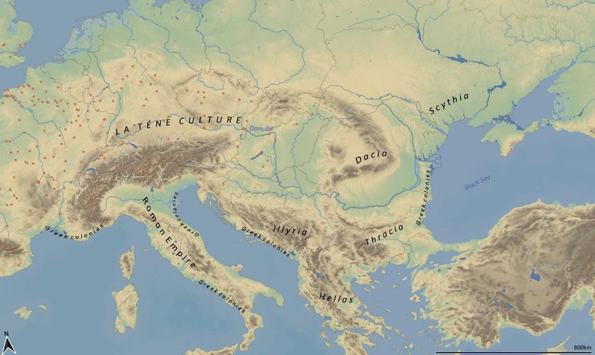
Routes4U Feasibility study on an Iron Age cultural route in the Danube Region

CONTENTS
     Contents ................................................................................................................................................................... 3
 I.  EXECUTIVE SUMMARY ........................................................................................................... 5
 II. ANALYSIS OF THE “STATE OF THE ART” OF IRON AGE HERITAGE IN THE
 DANUBE REGION................................................................................................................................ 6

     1. Cultural-historical background ............................................................................................................................ 6

     2. Research background........................................................................................................................................... 8
    Subsample Iron Age Danube ............................................................................................................................. 10

     3. Dissemination and presentation background ................................................................................................... 13
    Subsample Iron Age Danube ............................................................................................................................. 13

     4. Iron Age sites and characteristics by country ................................................................................................... 14

     3. Analysis of the “state of the art” of the entities/networks.............................................................................. 31
    Recommendation 1.1. ....................................................................................................................................... 39
    Recommendation 1.2. ....................................................................................................................................... 39
    Recommendation 1.3. ....................................................................................................................................... 39
    Recommendation 1.4. ....................................................................................................................................... 40
    Recommendation 2.1. ....................................................................................................................................... 40
    Recommendation 2.2. ....................................................................................................................................... 40
    Recommendation 2.3. ....................................................................................................................................... 40
    Recommendation 2.4. ....................................................................................................................................... 40
    Recommendation 2.5. ....................................................................................................................................... 40
    Recommendation 3.1. ....................................................................................................................................... 40
    Recommendation 4.1. ....................................................................................................................................... 41
    Recommendation 4.2. ....................................................................................................................................... 41
    Recommendation 5.1. ....................................................................................................................................... 41
    Recommendation 5.2. ....................................................................................................................................... 41
    Recommendation 5.3. ....................................................................................................................................... 41
    Recommendation 5.4. ....................................................................................................................................... 41

     Appendix 1 – Iron Age heritage inventory of sites and destinations ................................................................... 42
    Austria ............................................................................................................................................................... 42
    Bosnia and Herzegovina .................................................................................................................................... 43
    Bulgaria ............................................................................................................................................................. 44
    Croatia ............................................................................................................................................................... 45
    Czech Republic .................................................................................................................................................. 46
    Germany............................................................................................................................................................ 47
    Hungary ............................................................................................................................................................. 48
    Moldova ............................................................................................................................................................ 49
    Montenegro ...................................................................................................................................................... 49
    Romania ............................................................................................................................................................ 50
    Serbia ................................................................................................................................................................ 51
    Slovak Republic ................................................................................................................................................. 52

 www.coe.int/routes4u                                                                                                                                                   3 / 57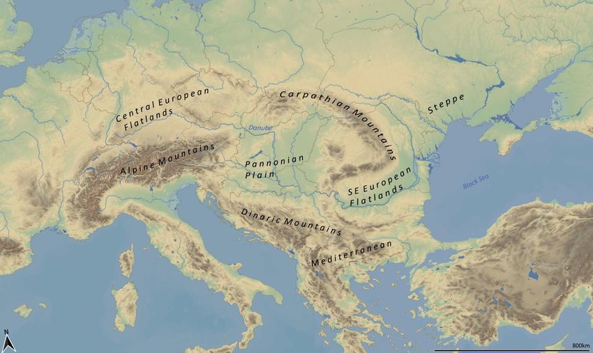
Routes4U Feasibility study on an Iron Age cultural route in the Danube Region

  Slovenia ............................................................................................................................................................. 53
  Ukraine .............................................................................................................................................................. 54

   Appendix 2 – References ....................................................................................................................................... 56
  Methodology..................................................................................................................................................... 56
  Cultural history.................................................................................................................................................. 56
  Data sources/databases .................................................................................................................................... 56

   Appendix 3 – Proposed methodology ................................................................................................................... 57

www.coe.int/routes4u                                                                                                                                                  4 / 57
Routes4U Feasibility study on an Iron Age cultural route in the Danube Region

I.   EXECUTIVE SUMMARY
     The Danube Region represents a melting pot for different cultures and influences in central Europe.
     We have hardly any written sources for the Iron Age – spanning the 1st millennium BC – so it is the
     archaeological material remains that show us how regional groups interacted and exchanged in a
     common cultural area. This heritage is to be placed at the centre of a proposed Cultural Route in
     order to improve its protection on an international level and to provide regions with an additional
     tourist offer.

     This study should represent a first step towards an itinerary of suitable sites and destinations in all the
     countries of the Danube Region. Following an analysis of the “state of the art” of Iron Age heritage in
     the region and general remarks on its presentation and the state of associated research, a list of 67
     entries (3 to 7 per country), with a basic characterisation for each country, has been compiled. The
     selection of sites has tried to keep to the goals of referring as much as possible to the whole Danube
     Region and reflecting its diversity as well as shared heritage. The sites and destinations are varied in
     nature and involve remote areas that are off the beaten track.
     The amount of available information was also variable across sites. Still, a first attempt at a
     qualification of site assets was done, considering such factors as:
         -   visibility: this mostly applies to archaeological remains and how visible they are at the site;
         -   accessibility: this considers how accessible the site is for private persons and groups;
         -   infrastructure: how well developed is the area? Are there restaurants, tourist information
             points and good transport connections?

     In Chapter 3, the entities and international networks managing these Iron Age heritage sites are
     analysed with a focus on the possibilities and obstacles in view of the co-operation among them at the
     transnational level, in the framework of a possible Cultural Route.
     Chapter 4 provides clear recommendations for further steps and on the assistance that is needed for
     the creation of a network for an Iron Age Cultural Route. The recommendations should help to
     support three basic components in the development of a Cultural Route:
         -   collaboration among actors;
         -   accessibility of information and facilities at the destinations;
         -   monitoring and evaluation.

     Three appendixes provide an inventory of sites and destinations with managing authorities (Appendix
     1), references and data sources for research (Appendix 2), and an abstract of the initially proposed
     and executed methodological design of the study (Appendix 3).

     www.coe.int/routes4u                                                                                      5 / 57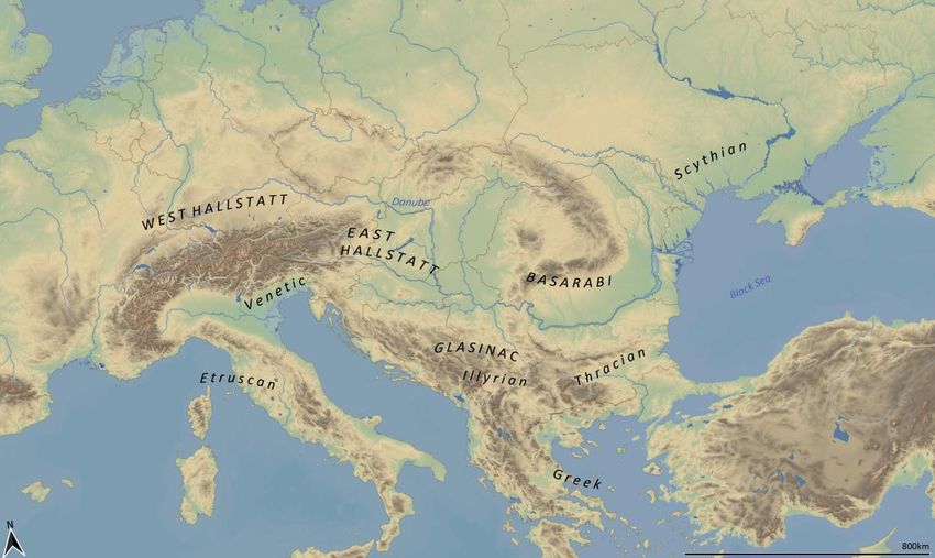
Routes4U Feasibility study on an Iron Age cultural route in the Danube Region

II.    ANALYSIS OF THE “STATE OF THE ART” OF IRON
       AGE HERITAGE IN THE DANUBE REGION

      1. CULTURAL-HISTORICAL BACKGROUND
       Sometimes developments in the history of humankind need a certain amount of time to be successful.
       This was also the case with iron, the material that gave its name to the last period of central
       European prehistory: the Iron Age. The technology of iron processing was introduced from the Middle
       East via the Balkans from the beginning of the first millennium BC. The metallurgical know-how of
       bronze production and processing had previously led to the formation of supra-regional networks,
       which increasingly lost their economic basis with the spread of iron. Iron technology is technically
       complex, but it has one big advantage: the raw material is much more widespread. Thus, from the
       9th century BC, Late Bronze Age cultural groups in the Danube area seized on the “democratisation” of
       this important raw material, with its new possibilities for the production of tools, weapons and clothing
       elements. Regional groups emerged that adopted new influences in burial rites from the East,
       increasingly interring their dead in the landscapes around their hilltop settlements under widely visible
       burial mounds. Soon, supra-regional elites formed that, in the course of the Iron Age, networked to
       form a cultural complex spanning large parts of central Europe: the Hallstatt World, with a core region
       divided into a western and eastern cultural complex (Fig. 1).

             Figure 1: The Iron Age archaeological cultural groups in the Danube and cultures in the
                                  neighbouring regions, 9th to 5th century BC.

       This elite upper class sought close exchanges with neighbouring cultures, e.g. Etruscan in           the
       southwest, Greek in the southeast and Scythian in the northeast (Fig. 1). In the 9th and             8th
       centuries BC, the northern Black Sea region was a main focal point for transcontinental contacts     and
       with the Danube as the connecting line, ideas from nomadic steppe cultures spread across             the

       www.coe.int/routes4u                                                                                  6 / 57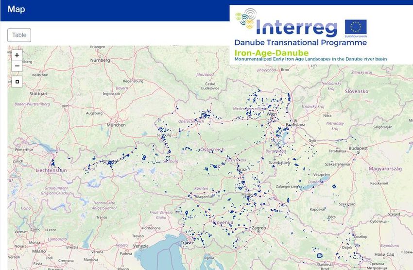
Routes4U Feasibility study on an Iron Age cultural route in the Danube Region

Carpathian Basin to the Alps. The most noticeable of these is the custom of burying prominent
personalities under monumental burial mounds with horse bridles, protective weapons of bronze such
as body armour and helmets, and rich drinking and eating utensils. The settlements were mostly built
on heights, often with terraces on the slopes and sometimes with fortification systems. Here,
uniformity is evident throughout the Danube Region, with increased steppe nomadic Scythian
influences in Ukraine, Moldova and Romania, elements of the Thracians in Bulgaria, and contacts with
the Illyrians in Croatia, Serbia, Montenegro, and Bosnia and Herzegovina, as well as relations with the
Greeks via their colonies, established along the Mediterranean and Black Sea coasts in the 8th to 4th
centuries BC. It has also been proven that the German, Austrian and Slovenian regions had
connections with the Venetic and Etruscan cultures.
We don’t have the names of most of the peoples considered as the bearers of the Hallstatt culture,
but on figurally decorated bronze vessels, so-called situlas, we see scenic representations from the
Iron Age. Their content shows connections to Homeric narratives, and thus we get an insight into the
imaginary world of that time. Especially in the course of the 7th to 5th centuries BC, the Hallstatt
culture of the older Iron Age was in close contact and constant exchange with the Italian, Greek and
Illyrian regions. In the 6th century BC, economic and political changes in the Mediterranean region
also had a significant impact on the western part of the Hallstatt culture. The influx of Mediterranean
products increased and in so-called “princely tombs”, the elite showcased its importance with
magnificent imported pieces.
It was also in the upper Danube Basin that new developments occurred in the 5th century BC that
were to influence large parts of Europe for the following five centuries. The contacts of the Hallstatt
upper class with the Mediterranean region stimulated the development of their own ideas in the 5th
century BC, which began to spread throughout Europe and manifested in their own style of art, as well
as their economic and cultic activities and modes of warfare.

    Figure 2: The Iron Age in the Danube and neighbouring regions, 5th to end of 1st century BC

The La Tène culture became predominant in central Europe during the later Iron Age (from the 5th to
the end of the 1st century BC, with regional variations) and is seen in connection with Celtic cultural
groups, whose designation as “Κελτοι” was handed down by Greek historians, or as “Celtae” or “Galii”
by Roman historians. In the 4th century BC, a new social order can be determined with the
disappearance of easily recognisable elite graves. Individual groups of farmsteads and small villages
represented the main form of settlement. Systems of regional nobility and armed henchmen enabled

www.coe.int/routes4u                                                                                7 / 57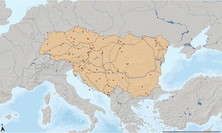
Routes4U Feasibility study on an Iron Age cultural route in the Danube Region

 warlike migrations of Celtic groups. In cemeteries near the settlements, warriors were typically buried
 with an iron sword, spear and shield. In the 3rd century BC, ancient authors tell us about warlike Celtic
 groups that advanced to Greece. Delphi was plundered in 279/278 BC, and in the course of these
 migrations the La Tène culture spread to the Balkans, the south-eastern Alps and Transcarpathia.
 While they predominated in most countries of the Danube Region, independent but closely linked
 cultural groups existed, above all, in the south and east. Illyrian and Thracian areas remained in the
 areas of the Dinaric Mountains and south of the Danube during the later Iron Age, and in Romania an
 independent Dacian cultural area developed at the Carpathian Arch.
 New forms of settlement appeared in the 2nd century BC. Large settlements, so-called “oppida”, were
 built along important routes. They functioned as regional centres and were mostly fortified or in a
 naturally protected location. As a focal point for trade and craft, they also had administrative
 responsibilities and often had their own coinage. Frequently, there are also iron processing sites in
 their vicinity. Iron ore was mined, smelted and sometimes even traded into the Roman Empire as
 export goods, the so-called “ferrum Noricum”.
 Contacts with their rapidly expanding southern neighbours were still loose at the time. Found goods at
 some sites show, already in the 1st century BC, growing exchange with the Roman Empire. But with
 the occupation of large parts of the area south of the Danube at the end of the 1st century BC, the
 Roman Empire brought its own infrastructure and administration to these now Roman provinces. In
 some regions, existing Iron Age centres were abandoned and new urban settlements were established
 away from them, often forming the base of today’s cities. While Roman social structures became
 dominant in the settlements and in the domain of crafts or the military, the Roman Empire also had
 an integrative character and in some regions existing religious sanctuaries could be interpreted in a
 Roman style and survive. On Roman tombstones, local names show that Celtic people had become
 citizens of Rome, and in some names of places, mountains and water bodies, Celtic heritage has been
 preserved as an intangible cultural asset to this day.

2. RESEARCH BACKGROUND
 Much of our knowledge about the central European Iron Age as the last prehistoric epoch in human
 history – before written records became regular – is based on the material legacy of the cultures of
 that time. Numerous monuments of the European Iron Age have been preserved from the almost
 thousand years of its existence. The best known and most present in the public awareness are
 artefacts from archaeological excavations, which are accessible to the interested public in state and
 private museums and collections covering a period of research spanning 200 years now. Numerous
 components of traditional dress, drinking and eating utensils, and magnificent weaponry have been
 recovered during excavations of burial mounds. Numerous graves have also been found that
 contained ornately decorated bronze and iron jewellery, glass and amber necklaces, and ceramic
 vessels. Excavations in settlements have uncovered everyday objects and objects of artistic
 craftsmanship, such as looms for textile production, pottery and forged goods. Organic materials are
 less frequently preserved, but at individual sites, such as in salt mines, textile and leather remains
 have been discovered and displayed in museums. At sacrificial sites and sanctuaries, particularly
 impressive collections of objects have been recovered including, in the Late Iron Age, weapons, very
 often made unusable by burning and bending in rites.
 In addition to this heritage, there are also numerous monuments, some of which have been preserved
 in relief in the meadows, pastures and woods of today’s landscapes. In many regions these consist of
 Iron Age burial mounds, which are accessible as individual monuments or in groups in rural areas,
 appearing as prehistoric remains to the untrained eye. It is much more difficult to recognise
 settlements and fortifications. Massive earthen ramparts, often with stone-faced walls underneath,
 represent a common form of fortification in Iron Age settlements that can still be seen today on some
 hills. However, individual residential buildings and houses, which were mainly constructed in wood,
 are usually no longer visible above ground.

 www.coe.int/routes4u                                                                                  8 / 57

Routes4U Feasibility study on an Iron Age cultural route in the Danube Region
In the past few decades, archaeologists have developed numerous methods to obtain information on
these invisible monuments. For a long time, excavations were considered the only way to investigate
underground archaeological structures. Modern technologies enable scientists today to proceed non-
destructively. Using various methods of archaeological prospection, sites can be discovered and three-
dimensional images made for analysis and presentation. By using remote sensing methods, terrain
models produced by airborne laser scanners, aerial photographs and satellite imagery, entire countries
can be systematically surveyed for archaeological material heritage. Through the use of geophysical
methods, recognised monuments can be examined and their structure visualised in three dimensions.
The increased systematic use of these methods in some countries has revealed numerous new
monuments, which have considerably broadened our picture of the Iron Age. Numerous previously
unknown settlements, but also remains of grave monuments obliterated by thousands of years of
agriculture, have been discovered in this way. Computer-generated images enable amateurs and the
interested public to observe these formerly invisible monuments.
However, due to different historical developments across physio-geographically varied regions (Fig. 2),
as well as variations in conservation conditions (Fig. 4) and the state of research, a more in-depth
comparison of the entire Danube Region remains difficult at the present time.
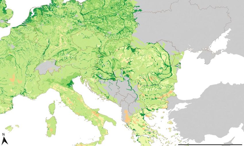
Figure 3: Biogeographical zones of the Danube Region
www.coe.int/routes4u 9 / 57Routes4U Feasibility study on an Iron Age cultural route in the Danube Region
Figure 4: Preservation capacity of cultural artefacts and buried materials in soils across the EU
(Dark green/Green/Light Green/Orange=Very good/good/fair/poor) (Kibblewhite, Tóth and
Hermann 2016)
Subsample Iron Age Danube
As part of the Interreg Iron-Age-Danube project (IAD: https://iron-age-danube.eu), a comprehensive
inventory of Iron Age monuments has been generated for four partner countries. All known sites
(1 046 in total) in Austria, Slovenia, Hungary (Transdanubia) and Croatia (Continental Croatia) have
been recorded in a database (Fig. 5) and their status evaluated with regard to research, protection
status and tourist presentation. For the other countries of the Danube Region, there is unfortunately
still no comparable collection of data that could enable us to evaluate the spatial extent of Iron Age
sites and their other attributes.
www.coe.int/routes4u 10 / 57Routes4U Feasibility study on an Iron Age cultural route in the Danube Region
Figure 5: Interreg Iron-Age-Danube site collection. Screenshot from https://iron-age-
danube.eu/browsing/sites/
In total, more than 1 000 Iron Age sites were mapped within the framework of the project in the four
countries (Fig. 6), which can be used as the basis for a statistical analysis of Iron Age heritage in this
sample.
Austria Croatia Hungary Slovenia
165
98
633
153
Figure 6: Number of collected sites per country. Data basis https://iron-age-
danube.eu/browsing/sites/
The ownership of the plots of land containing archaeological sites plays an important role in the
possibilities for research, protection and tourist use. Of the recorded sites, the ownership of more than
half could not be determined. For 236 sites, private-public ownership was determined, for 172 sites
dedicated private ownership was recorded, and only a small number – 37 sites – are in public hands
(Fig. 7). This has an effect on site management as negotiations have to be conducted with a large
number of private landowners, and private rights of use have to be weighed up against protective
measures, research projects and tourism use on a case-by-case basis.
www.coe.int/routes4u 11 / 57Routes4U Feasibility study on an Iron Age cultural route in the Danube Region
1 – private 172
2 – public 37
3 – private/public 236
4 – information not available 557
Field not populated 44
Figure 7: Ownership of land where sites are located. Data basis https://iron-age-
danube.eu/browsing/sites/
Archaeological heritage is fragile and exposed to hazards in many areas. Modern construction activity
and infrastructure projects, agricultural activity and land consolidation, as well as the extraction of
mineral resources or erosion, all endanger invisible archaeological heritage. However, increasing
tourist use can also worsen the state of conservation of archaeological sites. The collection of data by
the IAD project enables the comparison of small regions within the Danube Basin.
Due to the ownership situation, it does not come as a surprise that only 461 units are at least partially
protected and only about 240 units are under total protection within the possibilities afforded by
national legal frameworks for monument protection (Fig. 8). Furthermore, differences in national laws
are responsible for varying levels of protection across countries. A strategy paper, as an output of the
project, should ensure standardisation in the future. This should also be the objective for the other
countries of the Danube Region.
Austria Croatia Hungary Slovenia
151
214
26
74
Figure 8: Number of at least partially protected sites per country. Data basis https://iron-age-
danube.eu/browsing/sites/
www.coe.int/routes4u 12 / 57Routes4U Feasibility study on an Iron Age cultural route in the Danube Region 3. DISSEMINATION AND PRESENTATION BACKGROUND In addition to the discovery and investigation of the material legacy of Iron Age cultures, their scientifically presentation plays an important role. Since the middle of the 19th century, supra-regional and regional museums have been responsible for the exhibition of finds in various countries of the Danube Basin. At the time of the Austro-Hungarian Empire research activities initiated from Vienna (and Budapest) took place in large parts of the Danube Region in all crown lands, and targeted research trips to individual regions were carried out. Found material was often brought to Vienna, where it is now kept in the Natural History Museum. With the foundation of state museums and local archaeological custodians at the end of the 19th century, research was regionalised and the finds remained in individual countries. After the Second World War, the state museums continued to receive support and regional museums with archaeological departments were established in numerous socialist countries, often presenting finds from nearby archaeological sites. In addition to the presentation of artifacts and found objects a tradition of visualising archaeological heritage in the landscape developed throughout the 20th century. While Roman or medieval monuments are often easily identifiable as ruins or existing buildings, prehistoric monuments often require explanatory design at the archaeological sites. Through archaeological research, methods have been established for decades in which life-size architectural models are constructed in controlled experiments with accurate copies of artefacts in order to gain knowledge about the technology, procedures, material requirements and energy consumption required. At some Iron Age sites, scientific reconstructions of prehistoric buildings based on excavation findings have been erected as part of experimental archaeology projects. Integrated into open-air museums, they represent the ideal case of the presentation of an archaeological site. An alternative are open-air museums that are not built at the sites themselves, but whose models are based on scientific findings from the Iron Age, and which are dedicated to conveying prehistoric ways of life and technologies. In both museums, the staging of thematic events with a participatory character are very well accepted and are viewed as proven forms of knowledge transfer in the form of “edutainment” targeting broad groups of the interested public. A further type of presentation involves sites with preserved and interpreted excavation findings in situ, or information boards and descriptions of terrain features visible above ground, often as an archaeological path or within the framework of an archaeological park. Here, too, there are great differences across the individual regions of the Danube Region. The tradition of archaeological parks and open-air museums comes largely from northern Europe, where the first (ethnological) open-air museums were established at the end of the 19th century. Another wave of construction began in the 1970s, when ethnological museums were built in former socialist countries, as well as reconstructed areas at archaeological sites. In German-speaking countries, in particular, there are numerous archaeological open-air museums around important Iron Age sites, which have been expanded in the last two to three decades. Subsample Iron Age Danube The database of the project also registered the visibility of archaeological structures on site, which has an impact on the attractiveness of a locality for tourist use. Of the 1 041 sites recorded, 647 (62%) are not visible to visitors, 248 (24%) are visible on site and 36 (3.5%) offer visitors reconstructed or interpreted elements of Iron Age structures (Fig. 9). www.coe.int/routes4u 13 / 57
Routes4U Feasibility study on an Iron Age cultural route in the Danube Region

  1 – reconstructed and interpreted onsite         36

            2 – visible, but not interpreted                    248

       3 - invisible archaeological heritage                                                         647

             4 – information not available              110

                       Field not populated     5

          Figure 9: Visibility of sites. Data basis https://iron-age-danube.eu/browsing/sites/

 As part of the project, tourism measures were developed in the partner countries at Iron Age sites in
 nine micro-regions (Großklein and Strettweg – Austria; Jalžabet and Kaptol – Croatia; Poštela and
 Dolenjske Toplice – Slovenia; Százhalombatta, Süttő and Sopron – Hungary). Some have already been
 implemented in the form of archaeological information paths, but in the future they will extend to
 visitor information centres at the sites.

4. IRON AGE SITES AND CHARACTERISTICS BY
COUNTRY
 One of the goals of a collection of potential destinations for a Cultural Route is to show diversity in the
 type of sites. To better characterise them the following chapter offers some basic data on countries
 and sites in the Danube Region. There is a clear gap in the availability of data between countries that
 were part of the IAD project or the Danube Region of Germany, where research and presentation of
 archaeological heritage has a long tradition, and regions of the lower Danube. The same applies to
 the Czech Republic and Slovakia, where well-developed Iron Age sites are present, especially
 monumental fortifications. Still, candidates have also been identified in more remote regions, where
 the development of more far-reaching tourist offers will still have to be advanced. Two of the
 identified sites are outside the actual Danube Basin, but were nevertheless left in the data collection,
 as they are important Iron Age sites and are in countries belonging to the Danube Region, although
 they may not be considered in further steps.

 www.coe.int/routes4u                                                                                  14 / 57
Routes4U Feasibility study on an Iron Age cultural route in the Danube Region
Figure 10: Map of identified destinations in the Danube Region
The following sections illustrate the characteristics of Iron Age heritage for each country and provide
additional information onsite considered for the itinerary described in Appendix 1.
Accessibility: Visibility: Infrastructure:
1 - accessible by public transport 1 - reconstructed and interpreted 1 - complete infrastructure
2 - accessible for individual tourist onsite 2 - basic infrastructure
groups 2 - visible, but not interpreted 3 - no infrastructure
3 – inaccessible 3 - invisible archaeological heritage 4 - information not available
4 - information not available 4 - information not available
Legend: …Archaeological remains ...Museum …Village/Town …Association
Austria
The significance of Iron Age heritage for Austria can clearly be seen from the fact that the older
European Iron Age is referred to as the Hallstatt Period after the discoveries in Hallstatt in the
Austrian Alps. Therefore, the selection was extended to seven candidates reflecting different aspects
of the Iron Age. It includes a mining/industrial area, cemeteries with large monuments, settlements
with representative fortifications and cult sites with connections to the Venetians. Accessibility is very
good throughout, and the presentation on site ranges from archaeological paths to reconstructions of
parts of Iron Age settlements.
www.coe.int/routes4u 15 / 57Routes4U Feasibility study on an Iron Age cultural route in the Danube Region
A1 Austria, Hallstatt WGS84 47.561953 / 13.648957
Character: Cemetery; salt mine. Accessibility: 1, Visibility: 1,
Infrastructure: 1
Tourism: Fully developed. Archaeological remains, salt mine, activities on the lake,
mountaineering.
Eponymous find site of the older Iron Age with prehistoric cemetery and salt mining in the Upper
Austrian Alps. The village is not only known for its salt, it is famous for its picturesque
appearance, its location at Lake Hallstatt, the painted skulls in the medieval karner (ossuary)
and, above all, because it bears the name that describes the Hallstatt culture; since 1997 Hallstatt
has been a World Heritage Site. Of note are the environmental conditions in the salt mine, which
meant that organic material such as textiles, leather and raw hides were preserved, offering rare
insight into a material cultural group. Hallstatt is an important trade hub of the Iron Age and
imported goods from the west and east demonstrate its position at the intersection of the eastern
and western circles of the older Iron Age.
A2 Austria, Strettweg WGS84 47.176458 / 14.657991
Character: Cemetery; settlement. Accessibility: 2, Visibility: 2,
Infrastructure: 3
Tourism: Touristic offer in development.
Hilltop settlement, surrounded by associated burial mound groups. Known for Strettweg cult
wagon displayed in Universalmuseum Joanneum at Schloss Eggenberg in Graz. The Stadtmuseum
Judenburg holds a replica.
A3 Austria, Großklein WGS84 46.740402 / 15.436766
Character: Cemetery. Accessibility: 2, Visibility: 1,
Infrastructure: 1
Tourism: Fully developed.
On the Burgstallkogel (458 m) near Kleinklein an extensive Urnfield and Hallstatt-temporal hilltop
settlement is documented. This was one of the most important political and economic centres of
the Alpine Region in the older Hallstatt Period. Multiple groups of burials can be found in the
surrounding area.
A4 Austria, Gurina WGS84 46.668972 / 13.085337
Character: Settlement; cemetery; sanctuary. Accessibility: 2, Visibility: 1,
Infrastructure: 2
Tourism: Touristic offer in development.
On the hill Gurina on the northern side of an alpine valley in Carinthia settlement structures, burial
mounds and a sanctuary from the Early Iron Age, running into the Roman Period, have been
excavated. It is most famous for Venetic inscriptions showing that this site was an important
communication point between the Hallstatt culture and northern Italic cultural groups. It is also
one of the first points that shows Roman contact with a late Celtic alpine territory.
A5 Austria, Schwarzenbach WGS84 47.638142 / 16.362059
Character: Settlement. Accessibility: 2, Visibility: 1,
Infrastructure: 2
Tourism: Fully developed. Marked trails (archaeological, bird observation path, etc.):
www.schwarzenbach.gv.at/Freizeit_Wirtschaft/Sehenswuerdigkeiten
Neolithic, Bronze Age and Late Iron Age hilltop settlement. Massive Late Iron Age fortification,
thus considered a local oppidum. In situ reconstruction of parts of the excavated Late Iron Age
www.coe.int/routes4u 16 / 57Routes4U Feasibility study on an Iron Age cultural route in the Danube Region
settlement through experimental archaeology.
A6 Austria, Mitterkirchen im Machland WGS84 48.195935 / 14.726781
Character: Settlement. Accessibility: 1, Visibility: 1,
Infrastructure: 1
Tourism: Touristic offer in development.
Reconstruction of a Hallstatt culture village, experimental archaeology.
A7 Austria, Dürrnberg WGS84 47.667558 / 13.089970
Character: Cemetery; settlement; salt mine. Accessibility: 2, Visibility: 1,
Infrastructure: 1
Tourism: Fully developed.
Important site with several settlements, salt mining areas and funerary sites from the Hallstatt
and La Tène Periods.
Bosnia and Herzegovina
In Bosnia, Glasinac sites represent the most important type of Iron Age site, the findings of which are
mostly preserved in the Zemaljski muzej Bosne i Hercegovine. Large areas of Bosnia were part of the
Glasinac culture group, associated with Illyrian tribes. Locations in the terrain are generally not well
developed and there have been few efforts to visualise them on site so far.
BiH1 Bosnia and Herzegovina, Donja Dolina WGS84 45.146384 / 17.248870
Character: Settlement. Accessibility: 2, Visibility: 3,
Infrastructure: 2
Tourism: Touristic offer in development.
Trading centre.
BiH2 Bosnia and Herzegovina, Glasinac WGS84 44.293054 / 18.087499
Character: Cemetery; settlement. Accessibility: 2, Visibility: 2,
Infrastructure: 3
Tourism: Touristic offer in development. Caves, hiking, skiing, religious tourism:
https://turizamrs.org/en/sokolac/
Area of several sites – settlement, tumuli in vicinity of Sokolac.
BiH3 Bosnia and Herzegovina, Pod kod WGS84 44.047728 / 17.446435
Bugojna
Accessibility: 2, Visibility: 2,
Character: Settlement. Infrastructure: 3
Tourism: No or little attempts for tourism. Hunting.
Hillfort in Čipuljić (part of Bugojno).
Bulgaria
During the Iron Age, the area occupied by present-day Bulgaria was inhabited by Thracian cultural
groups with close contact with the Greek area. Stone architecture and numerous monumental burial
www.coe.int/routes4u 17 / 57Routes4U Feasibility study on an Iron Age cultural route in the Danube Region
mounds and dolmens ensure good visibility on site. Sveštari/Sboryanovo, a UNESCO World Heritage
Site, includes numerous monuments from the Iron Age. While there are good offers for tourists in an
archaeological park, other sites could still be expanded.
BG1 Bulgaria, Ada Tepe WGS84 41.433335 / 25.650000
Character: Gold mine. Accessibility: 2, Visibility: 2,
Infrastructure: 3
Tourism: No or little attempts for tourism.
There are plans to create a modern open-air museum, dedicated to mining and metallurgy, near
the Ada Tepe hill.
BG2 Bulgaria, Zlatosel WGS84 42.500000 / 25.000001
Character: Dolmen. Accessibility: 3, Visibility: 2,
Infrastructure: 3
Tourism: No or little attempts for tourism.
Bulgaria’s largest dolmen so far (discovered in 2015), named “stone egg”, near Zlatosel. There is
also a stela on site, and many Thracian dolmen are located nearby.
BG3 Bulgaria, Perperikon WGS84 41.642751 / 25.368720
Character: Settlement; religious centre. Accessibility: 2, Visibility: 2,
Infrastructure: 2
Tourism: No or little attempts for tourism.
The archaeological complex is situated in a rocky landscape and has been used as sanctuary since
neolithic times; a large round altar was hawn out of the rock in Iron Age. In this time it was used
by Thracians and considered as a sacred site, where enthronement ceremonies should have taken
place. A rocky mountain top has been enclosed by a stone wall in the time between the 4 th and
1st century BC.
BG4 Bulgaria, Sveštari/Sboryanovo WGS84 43.745238 / 26.766613
Character: Cemetery. Accessibility: 2, Visibility: 1,
Infrastructure: 1
Tourism: Touristic offer in development. UNESCO World Heritage Site.
The Sboryanovo Historical Archaeological Reserve is a complex of 140 sites and includes a fortified
Tracian city, a Thracian sanctuary and the Sveshtari Tomb, a necropolis and sanctuary of a
Thracian king. Since 1985 it is listed as a UNESCO World Heritage site.
Croatia
During the Iron Age, Croatia was at the crossroads of several cultural influences. Necropolises in the
north show elements from the steppe nomadic area, while Illyrian influences predominate in the
south. In the coastal area Greek influences can be seen through numerous colonies up to the northern
Adriatic Sea. The settlement area of the Histri is presumed to have been in the Istrian area. As part of
the IAD project, an extended presentation was planned at two sites, from information paths to visitor
centres on site, and in some cases has already been implemented.
www.coe.int/routes4u 18 / 57Routes4U Feasibility study on an Iron Age cultural route in the Danube Region
CRO1 Croatia, Kaptol (Požega) WGS84 45.456207 / 17.729991
Character: Cemetery; settlement. Accessibility: 2, Visibility: 2,
Infrastructure: 2
Tourism: Touristic offer in development. Bike trails, hiking, wine region.
Important site with settlements from the Early Iron Age to Late Iron Age. Large tumuli groups
with princely tombs.
CRO2 Croatia, Jalžabet WGS84 46.260836 / 16.489250
Character: Cemetery. Accessibility: 2, Visibility: 2,
Infrastructure: 2
Tourism: No or little attempts for tourism.
Large monumental tumuli with opulent burials from the Early Iron Age. Besides the known and
visible tumuli other mounds have been detected by archaeological prospection. Some settlement
finds and assumed settlement areas that need further clarification. Visitor centre planned in the
near future.
CRO3 Croatia, the island of Vis (Issa) WGS84 43.064753 / 16.185305
Character: Cemetery; settlement. Accessibility: 2, Visibility: 1,
Infrastructure: 1
Tourism: Fully developed. Summer and nautical tourism, historical tourism (e.g.
fortresses, churches, submarine shelter).
Most important Greek colony in Croatia. Mostly destroyed, but lately new excavation and
protection is being carried out. Also Roman remains.
CRO4 Croatia, Sisak WGS84 45.484186 / 16.372137
Character: Settlement. Accessibility: 1, Visibility: 1,
Infrastructure: 1
Tourism: Fully developed. Historic city.
In the Iron Age, Segestika was the oldest proto-urban entity in continental Croatia. Mostly visible
Roman remains (archaeological park Siscia in situ). Archaeological park Sv. Kvirin to be opened.
CRO5 Croatia, Vizače (Nesactium) WGS84 44.916843 / 13.969180
Character: Settlement. Accessibility: 2, Visibility: 1,
Infrastructure: 2
Tourism: Touristic offer in development.
A prominent centre for the Illyrian Histrians in the first millennium BC. They continued to live there
right up to late classical times, that is the early Christian era. In Nesactium, bronze pails decorated
with figures, fragments of jewellery, weapons and ceramics have been found, along with
examples of monumental stonework, representing the greatest achievements of prehistoric artistic
creativity on Croatian soil.
Czech Republic
The present-day Czech Republic lay at the heart of the Hallstatt culture of the older Iron Age and the
La Tène culture of the later Iron Age. Numerous fortified hilltop settlements, some of which have been
well researched, can be found in this area. Some have been made accessible to the public with
www.coe.int/routes4u 19 / 57Routes4U Feasibility study on an Iron Age cultural route in the Danube Region
information paths and offer modern lookout towers and partial reconstructions of archaeological
remains.
CZ1 Czech Republic, Boudy WGS84 49.459311 / 14.029325
Character: Settlement. Accessibility: 2, Visibility: 2,
Infrastructure: 3
Tourism: No or little attempts for tourism.
One of the best documented and well-preserved Hallstatt period hilltop settlements, known as
"Hrad", at Čimelice. The site consists of two dry-stone walls and an inner wall, all of which
surround the top of the dominant hill, 574 m above sea level near the Lomnice and Skalice rivers.
CZ2 Czech Republic, Býčí skála WGS84 49.307436 / 16.694831
Character: Cave. Accessibility: 2, Visibility: 2,
Infrastructure: 3
Tourism: Touristic offer in development. Natural park, speleology.
Traces of settlements in the cave Býčí skála in the Moravian Karst range from the Palaeolithic to
the early Iron Age and were discovered in the middle of the 19th century. The most famous Iron
Age find is the bronze statuette of a bull. Ceramic and bronze vessels, iron weapons, decorative
gold and bronze objects, glass and amber beads and the remains of three or four carriages were
found at two large burial sites with the remains of 40 people. The interpretation of the site
remains unclear; a ritual or sacrificial function is most likely. The cave is 7 km long and
archaeological material has been found at the entrance. During the Second World War, the cave
was irreparably damaged when a concrete floor was laid in the entrance hall. The Býčí skála cave
is currently not open to the public. Guided tours take place three times a year.
CZ3 Czech Republic, Stradonice u Pátku WGS84 50.372903 / 13.970250
Character: Settlement. Accessibility: 2, Visibility: 2,
Infrastructure: 3
Tourism: No or little attempts for tourism.
As a rare example this hilltop settlement is not covered by forest today and therefore offers a
panoramic view of the Central Bohemian highlands.
The construction of the Hallstatt fortification on the site "Na šancích" consists of several sections
built with different techniques. A monumental wooden and earth rampart on the northeast side
originally had a frontal stone wall, a palisade and an outer ditch. Today, the watchtower
"Stradonka" stands on the rampart, which was erected in an supposed Iron Age construction.
CZ4 Czech Republic, Šťáhlavy (Hájek) WGS84 49.666514 / 13.546958
Character: Cemetery. Accessibility: 1, Visibility: 1,
Infrastructure: 2
Tourism: Touristic offer in development. Historical landmarks, Kozel forest.
The "František Xaver Franc Archaeological Nature Trail" is named after a local amateur
archaeologist of the 19th century. The trail leads through the "Kozel" forest, where a remarkable
number of prehistoric and medieval relics have been preserved, since the area has been covered
by a forest for a long time. In addition to an eneolithic hilltop settlement, there is a Bronze and
Iron Age burial cemetery.
CZ5 Czech Republic, Věnec WGS84 49.098825 / 13.870708
Character: Settlement. Accessibility: 2, Visibility: 1,
Infrastructure: 2
www.coe.int/routes4u 20 / 57Routes4U Feasibility study on an Iron Age cultural route in the Danube Region
Tourism: No or little attempts for tourism.
This monumental “Věnec” (“Wreath” in Czech) Hallstatt Period hillfort is situated at the edge of
the inhabited foothills of the Šumava Mountains. Its massive fortification consists of an “acropolis”
and an extensive annexe. The whole enclosed fortified area covers nearly 8 ha. The ramparts are
made of stone walls attached to natural rock at a number of places. Due to the limited
excavations and a small number of finds, we can only speculate about the function of the site. It
most probably served as an occasional refuge or gathering point of local people rather than a
permanent residence.
CZ6 Czech Republic, Všestary WGS84 50.2591639 / 15.761833
Character: Museum. Accessibility: 2, Visibility: 1,
Infrastructure: 1
Tourism: Touristic offer in development.
Open-air prehistory museum with experimental archaeology.
CZ7 Czech Republic, Závist WGS84 49.378337 / 16.572344
Character: Settlement. Accessibility: 2, Visibility: 1,
Infrastructure: 2
Tourism: No or little attempts for tourism.
There is easy access to the oppidum of Závist. Today, it is covered by woodland, but parts of the
fortification are still visible, with several gates and an “acropolis” at the summit. Between 1963
and 1989, the site was regularly excavated by the Archaeological Institute of Prague. It is listed as
a historic monument. A footpath with several information boards leads to the acropolis at the top
of the oppidum. Here, the visitor will find several information boards, and colour-marked signs
that indicate the main archaeological remains.
Germany (Baden-Württemberg and Bavaria)
Germany’s Iron Age heritage is characterised by numerous monumental burial grounds associated
with an elite upper class. These so-called princely graves date from the older Iron Age. The Upper
Danube Region belongs to the core of the Hallstatt and La Tène culture. Fortified Hallstatt settlements
designated as princely residences (Fürstensitze) and well-researched Celtic oppida are also well
developed for tourism.
DE1 Germany, Heuneburg WGS84 48.095528 / 9.411346
Character: Settlement; cemetery. Accessibility: 2, Visibility: 1,
Infrastructure: 1
Tourism: Touristic offer in development.
Reconstructed Celtic settlement and archaeological trail to the tumuli in the vicinity.
DE2 Germany, Glauberg WGS84 50.306345 / 9.006770
Character: Settlement. Accessibility: 2, Visibility: 1,
Infrastructure: 2
Tourism: Touristic offer in development.
Archaeological park (not in the Danube Region).
DE3 Germany, Hochdorf WGS84 48.88916 / 9.002911
Accessibility: 2, Visibility: 1,
www.coe.int/routes4u 21 / 57Routes4U Feasibility study on an Iron Age cultural route in the Danube Region
Character: Settlement; cemetery. Infrastructure: 1
Tourism: Touristic offer in development.
Archaeological park at a famous Early Iron Age site consisting of a princely tomb in a tumulus.
DE4 Germany, Manching WGS84 48.712852 / 11.493132
Character: Settlement. Accessibility: 1, Visibility: 1,
Infrastructure: 1
Tourism: Fully developed: www.manching.de/freizeit-kultur-und-tourismus
Famous archaeological site consisting of a large enclosed Late Iron Age settlement, partly
excavated with a visitor centre.
DE5 Germany, Altmühltal WGS84 48.923082 / 11.850944
Character: Settlement. Accessibility: 1, Visibility: 1,
Infrastructure: 1
Tourism: Fully developed.
The Archaeological park includes many Iron Age sites in the surroundings of the large Late Iron
Age Oppidum Kelheim. There are 18 stations along a 39 km route and more than 50 events are
organised during the year. Some of the stations offer in situ reconstructions of Iron Age
monuments.
Hungary
In the older Iron Age, the Carpathian Basin was part of the Hallstatt culture, to which numerous
settlements and burial mounds bear witness. In the younger Iron Age, Celtic tribes settled in the
central region and Thracian influences can be found in the east. Individual sites are well developed for
tourism and the open-air museum in Százhalombatta offers visitors opportunities for interactive
activities.
HU1 Hungary, Velem-Szentvid WGS84 47.351750 / 16.477183
Character: Settlement. Accessibility: 2, Visibility: 2,
Infrastructure: 3
Tourism: Touristic offer in development.
Fortified hilltop settlement surrounded by tumuli and a flat cemetery.
HU2 Hungary, Százhalombatta WGS84 47.336242 / 18.938710
Character: Cemetery; settlement. Accessibility: 1, Visibility: 1,
Infrastructure: 1
Tourism: Touristic offer in development.
Open-air museum. A large tumulus field with more than a hundred visible burial mounds, and a
hilltop fortified settlement on a loess plateau next to the Danube.
HU3 Hungary, Sopron WGS84 47.664360 / 16.559621
Character: Cemetery; settlement. Accessibility: 2, Visibility: 1,
Infrastructure: 2
Tourism: Fully developed. Sopron as historical town.
Fortified hilltop settlement with a tumulus cemetery. An Interreg archaeological trail leads past
www.coe.int/routes4u 22 / 57Routes4U Feasibility study on an Iron Age cultural route in the Danube Region
some visible remains and reconstructions.
HU4 Hungary, Hungarian National Museum WGS84 47.491058 / 19.061830
Character: Museum. Accessibility: 1, Visibility: 1,
Infrastructure: 1
Tourism: Fully developed. Capital and historic city.
Old museum with large collection of Iron Age finds from all over Hungary, collected from the time
of the Austro-Hungarian Empire.
Moldova
In the area of present-day Moldova, burial rites of the Hallstatt culture can be traced that were
adopted in the Iron Age. The production and trade of iron played an important role in the society of
that time. This epoch also forms the foundation stone for the Geto-Dacian culture, which existed from
the 6th century BC to the 1st century AD. Fortified settlements such as Saharna Mare played an
important role. Coins and amphorae are also evidence of trade relations with Greece. In Saharna Mare
there is a good tourist offer, and other places could be further developed.
MO1 Moldova, Saharna Mare WGS84 47.694327 / 28.962390
Character: Settlement. Accessibility: 2, Visibility: 2,
Infrastructure: 3
Tourism: Touristic offer in development. Saharna monastery.
Hilltop settlement.
MO2 Moldova, Old Orhei (region) WGS84 47.305512 / 28.974968
Character: Settlement. Accessibility: 2, Visibility: 2,
Infrastructure: 2
Tourism: Touristic offer in development. Culture, nature.
The Orheiul Vechi Archaeological Landscape is in the central-eastern part of Moldova along the
gorge of the lower course of the Răut River, 14 km upstream from its confluence with the Dniester
River. There are Iron Age settlements on the “Peştera” and “Butuceni” promontories.
MO3 Moldova, National Museum of History WGS84 47.022585 / 28.828131
of Moldova
Accessibility: 1, Visibility: 1,
Character: Museum. Infrastructure: 1
Tourism: Touristic offer in development. Capital city of Moldova.
The National Museum of Archaeology and History of Moldova is one of the most important museum
institutions of the country and offers unique finds from the Iron Age. One of the highlights is the
Olanesti treasure, consisting of six helmets and five greaves dated to the 5 th century BC.
Montenegro
Illyrian tribes founded small empires in the area of present-day Montenegro such as Labeates and
Ardiaei When the Romans were able to subdue the Illyrian tribes, they were partly romanised. Later
Roman cities, such as Doclea, have a distinct Iron Age prehistory. As parts of nature parks, the tourist
offers are good, but could benefit from further informational elements.
www.coe.int/routes4u 23 / 57Routes4U Feasibility study on an Iron Age cultural route in the Danube Region
MONT1 Montenegro, Doclea WGS84 42.467328 / 19.266323
Character: Settlement. Accessibility: 2, Visibility: 1,
Infrastructure: 1
Tourism: Touristic offer in development.
Archaeological park and museum. Mostly Roman.
MONT2 Montenegro, Gotovuša WGS84 43.274536 / 19.446775
Character: Cemetery. Accessibility: 2, Visibility: 2,
Infrastructure: 3
Tourism: Touristic offer in development. Climbing,
hiking.
In the area of Gotovuša and in the valley of the river Cehotina, many burial mounds from the Iron Age
have been discovered, along with fortified settlements.
MONT3 Montenegro, Mijela WGS84 42.227595 / 19.103801
Character: Settlement; Cemetery. Accessibility: 2, Visibility: 2,
Infrastructure: 1
Tourism: Fully developed. Lake tourism.
Tumuli in Humski zaliv (bay).
Romania
Local Iron Age culture in Romania was enriched by the expansion of the La Tène culture with a new
component of material culture, which is reflected in fortified hilltop settlements such as Ciumești.
Several fortifications were built in the core area of the Late Iron Age Dacian settlement area, as well
as Sarmizegetusa Regia, which is considered the core of a political unit of that time. The
archaeological park is well developed and is part of the infrastructure under UNESCO World Heritage
status.
RO1 Romania, Sarmizegetusa Regia WGS84 45.622718 / 23.310437
Character: Museum; settlement. Accessibility: 2, Visibility: 1,
Infrastructure: 2
Tourism: Touristic offer in development.
This fortress was built in the 1st century BC and under Dacian rule. It shows an unusual fusion of
military and religious architecture from the classical world and the Late European Iron Age. It was
considered the core of the Dacian kingdom, and was conquered by the Romans at the beginning of
the 2nd century AD. It is an archaeologcial park with UNESCO World Heritage status.
RO2 Romania, Șimleu Depression WGS84 47.214455 / 22.534318
Character: Settlement. Accessibility: 2, Visibility: 2,
Infrastructure: 3
Tourism: No or little attempts for tourism.
There are three hillforts: a Middle Bronze Age Hillfort on Pleșa hill; an Early Iron Age fortified
settlement on the hill of Iertașul Petacilor; and a fortified settlement from the end of the Early Iron
Age on Paliș hill. All are in the direct vicinity of Marca village.
www.coe.int/routes4u 24 / 57You can also read