Submission draft Ombersley and Doverdale Neighbourhood Development Plan 2020-2030 - Wychavon District Council
←
→
Page content transcription
If your browser does not render page correctly, please read the page content below
Ombersley and Doverdale Neighbourhood
    Development Plan 2020-2030

      Submission draft

   DJN Planning Limited · February 2021 · For Ombersley and Doverdale Parish Council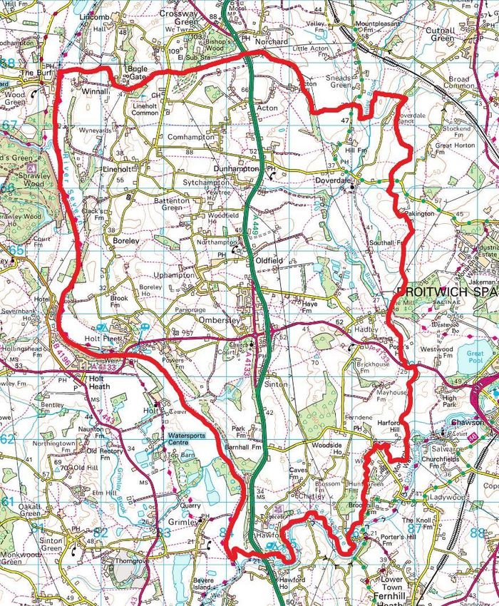
[this page blank]
CONTENTS                                                    Page

LIST OF POLICIES                                             1

1.   INTRODUCTION                                            2

2.   OMBERSLEY AND DOVERDALE NEIGHBOURHOOD AREA              5

3.   PLANNING POLICY CONTEXT                                15

4.   VISION AND OBJECTIVES                                  17
     Vision                                                 17
     Objectives                                             19

5.   SUSTAINABLE DEVELOPMENT                                20

6.   HOUSING, FACILITIES AND SERVICES                       21
     Housing mix                                            21
     Land north of Woodhall Lane, Ombersley                 23
     Community facilities                                   27
     Local retail and other services                        29

7.   NATURAL ENVIRONMENT                                    30
     Landscape and biodiversity                             30
     Landscape vistas                                       33
     Local Green Spaces                                     37

8.   BUILT ENVIRONMENT                                      41
     Design                                                 41
     Development affecting Conservation Areas               44

9.   ECONOMY                                                50
     Small-scale business development                       50
     Tourism and leisure                                    52
     Farm diversification                                   53
     Stand-alone renewable and low carbon energy projects   54

10. DELIVERING THE NEIGHBOURHOOD DEVELOPMENT PLAN           57
    Community actions                                       57

PLANS
1   Ombersley and Doverdale Neighbourhood Area               7
2   Context plan                                             8
3   Land north of Woodhall Lane, Ombersley                  26
4   Location of community facilities                        28
5   Landscape vistas                                        36
6   Millhampton Wood Local Green Space                      39
7   Local Green Spaces at Ombersley                         40
8   Ombersley Conservation Area                             48
9   Northampton and Uphampton Conservation Areas            49

APPENDICES
A: EVIDENCE BASE                                            60
B: LOCAL GREEN SPACES                                       62

ACKNOWLEDGEMENTS                                            65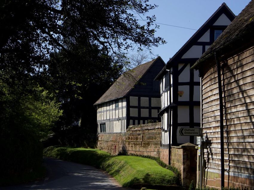
LIST OF POLICIES                                                                            Page

     Sustainable development
     TOAD1       Sustainable development                                                    20

     Housing, facilities and services
     TOAD2       Housing mix                                                                21
     TOAD3       Land north of Woodhall Lane, Ombersley                                     23
     TOAD4       Community facilities                                                       27
     TOAD5       Local retail and other services                                            29

     Natural environment
     TOAD6       Landscape and biodiversity                                                 30
     TOAD7       Landscape vistas                                                           33
     TOAD8       Local Green Spaces                                                         37

     Built environment
     TOAD9       Design                                                                     41
     TOAD10      Development affecting Conservation Areas                                   44

     Economy
     TOAD11      Small-scale business development                                           50
     TOAD12      Tourism and leisure                                                        52
     TOAD13      Farm diversification                                                       53
     TOAD14      Stand-alone renewable and low carbon energy projects                       54

Ombersley and Doverdale Neighbourhood Development Plan · Submission draft · February 2021          1
1.     INTRODUCTION
1.1    New planning powers were given to local communities by the Localism Act 2011. These
       include the ability to prepare Neighbourhood Development Plans as part of the statutory
       planning framework governing the development and use of land in the area. When planning
       applications are made, they must be decided in accordance with this framework unless there
       are overriding circumstances to the contrary.

Preparing the Neighbourhood Development Plan
1.2    Ombersley and Doverdale Parish Council decided to prepare a Neighbourhood Development
       Plan (NDP) in July 2017 to help ensure that decisions on future development are guided
       locally.

1.3    This version of the NDP has been prepared for submission to Wychavon District Council. It
       takes account of comments made following public consultation on a draft in 2020. The
       progress made through the plan preparation process is shown in Figure 1.

                                                   Community
          Parish Council decides                 engagement and                    Consultation on the
           to prepare an NDP                        informal                           draft NDP
                                                  consultations

                                               Submission of this
           Further consultation                                                     Revisions made in
                                              version of the NDP to
           by Wychavon District                                                      response to the
                                               Wychavon District
                 Council                                                               consultation
                                                     Council

                                                                                 NDP is ‘made’, gaining
               Examination                         Referendum                    full weight in planning
                                                                                        decisions

       Figure 1: Neighbourhood Development Plan preparation process

Ombersley and Doverdale Neighbourhood Development Plan · Submission draft · February 2021                  2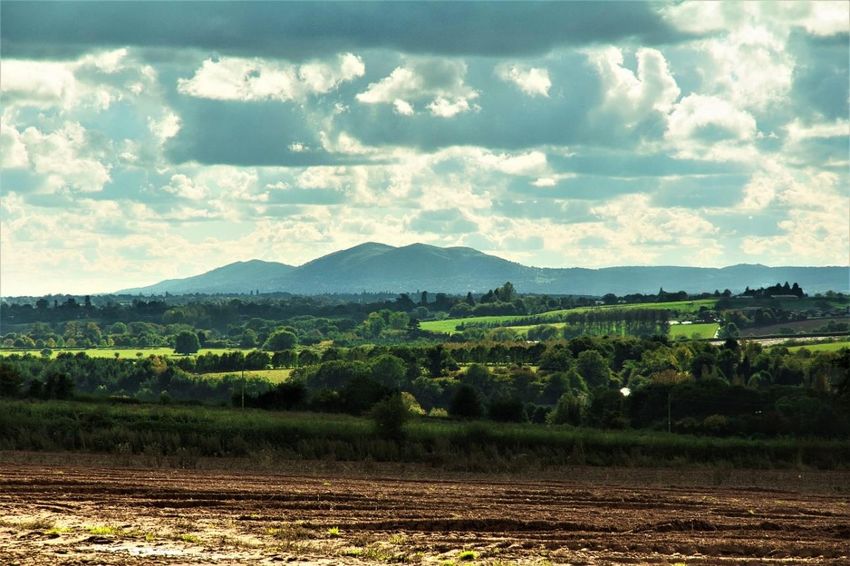
1.4    The NDP has been prepared by a Steering Group of Parish Councillors and other volunteers
       following a wide-ranging programme of community engagement and informal consultations,
       summarised below.

           Date                           Activity
           July-August 2017               Parish Council decision to proceed and informal meeting of
                                          Parish Councillors and local residents. The project was given a
                                          strong sense of identity through the TOAD acronym
                                          (Tomorrow’s Ombersley and Doverdale) and logo.
           September 2017                 Launch of the dedicated website www.toad.works and
                                          Facebook page.
           October 2017                   Circulation of a leaflet on the need for an NDP to households.
           November 2017                  Open public meeting at St. Andrew’s church, Ombersley, to
                                          introduce the NDP process, answer questions, seek views, and
                                          gather contact details.
           November 2017                  Drop-in coffee mornings at Sytchampton and Ombersley
                                          village halls.
           February 2018                  Steering Group formed.
           February – March 2018          Preferences survey (web-based).
           April – May 2018               Open spaces survey (web-based).
           June 2018                      Display stand at Ombersley church/school fete.
           August 2018                    Business survey (postal) with replies from 54 businesses, a
                                          response rate of 30%.
           August-September 2018          Vistas survey (web-based).
           October 2018                   Household survey (hand-delivered and collected) with replies
                                          from 622 households, a response rate of 63%.
           February 2019                  Drop-in coffee mornings at Sytchampton village hall and
                                          Ombersley Memorial Hall to provide feedback on household
                                          survey results and consult on sites for new housing.
           May 2019                       Preferred housing site survey (web-based).
           May 2019                       Drop-in event to seek further responses on housing sites.
           October – November 2020        Regulation 14 consultation on the draft NDP.

1.5    Regular communications to parishioners were also provided through:

       •       Monthly updates in the Parish Magazine.
       •       Updates on the dedicated website www.toad.works including minutes of meetings and
               survey reports, with email alerts.
       •       Updates published on the Parish Council website and on Parish noticeboards.
       •       A new parish website (from October 2019) www.allaboutombersley.com.

1.6    The NDP must be based on evidence about the characteristics of the parish. As well as the
       consultations and surveys listed above, detailed information has been gathered by four sub-

Ombersley and Doverdale Neighbourhood Development Plan · Submission draft · February 2021               3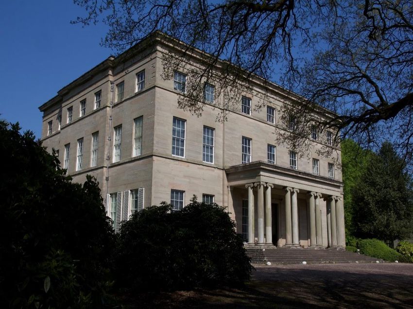
groups of volunteers on the themes of social, environment, business and traffic. Professional
       reports on housing and design have been commissioned and account taken of the 2009 Parish
       Plan. Reports and other documentation prepared for the South Worcestershire Development
       Plan have also been reviewed. The resultant ‘evidence base’ for the NDP is set out at
       Appendix A.

Ombersley and Doverdale Neighbourhood Development Plan · Submission draft · February 2021          4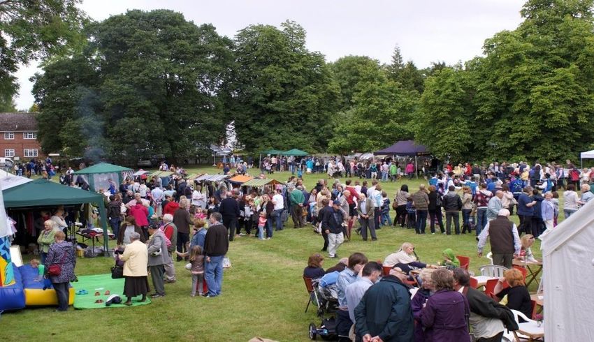
2.     OMBERSLEY AND DOVERDALE NEIGHBOURHOOD AREA
2.1    This chapter describes the Neighbourhood Area in terms of its social, environmental and
       economic characteristics which together contribute to a sense of place.

2.2    The Neighbourhood Area was designated by Wychavon District Council in August 2017 (Plan
       1). It comprises all of the parish of Ombersley and Doverdale, an area of 3,183 hectares
       between the River Severn and Droitwich in the County of Worcestershire (Plan 2). Ombersley
       and Doverdale Parish Council is the “qualifying body” responsible for the preparation of the
       NDP.

Social and community aspects
2.3    The main settlement is Ombersley village. Of Saxon origins, it has developed organically
       around the crossroads of the routes between Worcester and Kidderminster and Tenbury and
       Droitwich. Over time, the village has expanded from its medieval origins around the road
       junction (now a busy roundabout) in a mainly northerly direction, with modern estate-style
       development to the north-west. The principal north-south route through Ombersley, the
       A449, was re-routed onto an eastern bypass in 1974.

                         The old crossroads in Ombersley, as seen from the churchyard

Ombersley and Doverdale Neighbourhood Development Plan · Submission draft · February 2021           5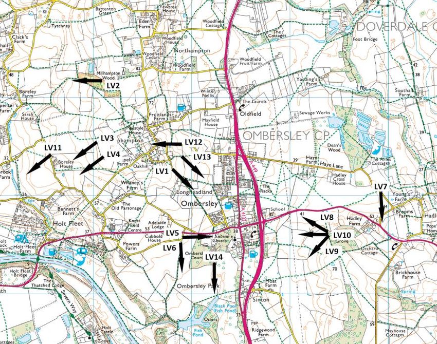
2.4    The Ombersley Estate has been an important influence on the development of the village.
       Ombersley Court, built in 1724, was the home of the late Sandys family until the death of Lord
       Sandys in 2013 and Lady Sandys in 2015. Today, the Ombersley Conservation Trust,
       established as a charity by Lord Sandys in 1993, is the major landowner in the parish. It aims
       to promote the conservation of lands and buildings, the protection, preservation and
       improvement of rural and visual character, and the amenities of the parishes for local public
       benefit. Ombersley Court is privately owned; the house and its landscaped setting to the
       south-west of the village contribute significantly to its character.

                                                   Ombersley Court

 2.5 Other settlements lie in the countryside around Ombersley. To the north of the village and
     served by the A449 are the Hamptons: Uphampton, Northampton, Sytchampton,
     Dunhampton and Comhampton. Other smaller villages and hamlets include Holt Fleet,
     Boreley, Lineholt, Chatley and Hadley. Doverdale lies to the north-east, a hamlet of 19
     dwellings.

2.6    The Neighbourhood Area is well-connected by road. The north-south dual carriageway A449
       connects to Worcester and junction 6 of the M5 in the south, and to Kidderminster in the
       north. The A4133 links to Droitwich and junction 5 of the M5 to the east. To the west it
       crosses the River Severn at Holt Fleet Bridge enroute to Tenbury Wells and the A49. It is a
       busy cross-country route which brings significant volumes of commuter, commercial
       (including HGV) and general traffic through the historic centre of Ombersley.

Ombersley and Doverdale Neighbourhood Development Plan · Submission draft · February 2021            6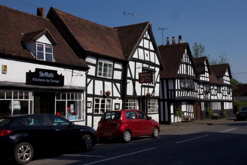
Ombersley and Doverdale Neighbourhood Area

               © Crown copyright and database rights (2019) Ordnance Survey (0100055485). Not to scale.

       Plan 1: Ombersley and Doverdale Neighbourhood Area

Ombersley and Doverdale Neighbourhood Development Plan · Submission draft · February 2021                 7
Ombersley and Doverdale Neighbourhood Area
© Crown copyright and database rights (2019) Ordnance Survey (0100055485). Not to scale.
Plan 2: Context plan
2.7 The nearest rail stations are at Kidderminster, Hartlebury, Droitwich, Worcester and
Worcestershire Parkway. There is a bus service between Kidderminster and Worcester which
serves Ombersley and other settlements in the Neighbourhood Area along the A449, and a
weekly community bus service from Droitwich to Holt Fleet via Ombersley. There are 320
footpaths (94.4 km) which are well used by locals and visitors and are highly valued.
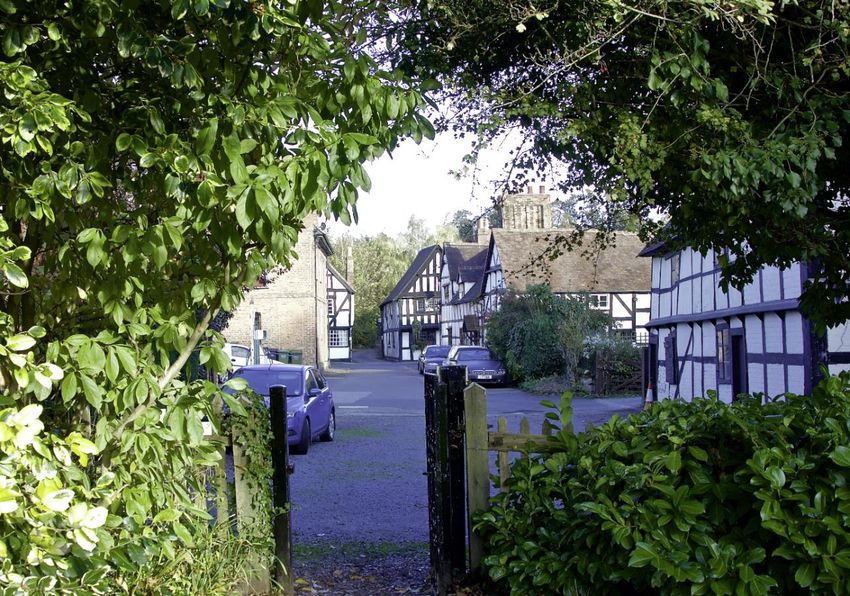
2.8 The Neighbourhood Area has a wide range of community facilities and services. Ombersley
village is the main focus of provision, home to St. Andrew’s church; a purpose-built medical
centre; a dental practice; Ombersley Endowed First School; and the Memorial Hall. The Hall
was opened in 1923 as a memorial to the fallen in the Great War, and today is used
extensively by many clubs and societies and as the polling station. There are also tennis,
cricket and bowls clubs in the village, and two bowling clubs at Hadley. Sytchampton to the
north has a village hall and an Endowed Primary School. Doverdale is home to St. Mary’s
church which in part dates from the 11th Century and is mentioned in Domesday.
Ombersley and Doverdale Neighbourhood Development Plan · Submission draft · February 2021 8Main road, Ombersley
2.9 Local shopping facilities are relatively limited given the size of population, including a
grocers/butchers/coffee shop in the centre of Ombersley, petrol filling stations in Ombersley
and on the A449, and a nursery and the Holt Fleet convenience stores on the A4133. There
are several public houses and a restaurant in Ombersley, and a number of catering outlets
along the A449 serving both local and passing trade.
2.10 The population of the Neighbourhood Area was 2,360 at the time of the 2011 Census, an
increase of 8% on the 2001 Census figure (2,178). This equates to a population density of 0.7
persons per hectare, less than that of Wychavon District (1.8 ppha) and England overall (4.1
ppha). The number of households also rose in this period, by 11% (906 to 1,003). As a result,
the average household size declined slightly from 2.4 persons per household in 2001 to 2.35 in
2011. The mid-2018 population estimate shows a further rise to 2,439 (up 3% on the 2011
figure).
2.11 Some 24% of the population were aged 65 and over in 2011, a slightly older age profile than
for Wychavon District (21%) (Figure 2). The proportion of older people was estimated to have
increased to 26% by 2018, with those of working age falling from 61% to 57% over this period.
Ombersley and Doverdale Neighbourhood Development Plan · Submission draft · February 2021 9% population by age group
30.0
25.0
20.0
% 15.0
10.0
5.0
0.0
10 to 14
0 to 4
5 to 7
8 to 9
16 to 17
18 to 19
20 to 24
25 to 29
30 to 44
45 to 59
60 to 64
65 to 74
75 to 84
85 to 89
15
90 and over
Ombersley & Doverdale Neighbourhood Area Wychavon
Figure 2: population by age group
2.12 In 2011 78% of homes were owner occupied, either outright or with a mortgage or loan,
slightly more than for the District as a whole (72%). Some 9% were social rented (District
14.5%), with 10% being privately rented, similar to the District (11%).
2.13 Detached properties accounted for 49% of all household spaces in 2011 (District 41%, England
22%) (Figure 3). Terraced properties were conversely less well-represented, accounting for
6% of household spaces in the Neighbourhood Area compared to 17% at District-level and
24% in England. This pattern is reflected in the size of properties, with 36% of household
spaces in the Neighbourhood Area having 4 or more bedrooms, compared to 29% at District
level. Some 14% of household spaces were accounted for by caravans or other mobile or
temporary structure (District 2%, England 0.4%).
Type of accommodation
60
50
40
% 30
20
10
0
Detached Semi-detached Terraced Flat/apartment Caravan/mobile
home
Ombersley and Doverdale Neighbourhood Area Wychavon England
Figure 3: type of accommodation
Ombersley and Doverdale Neighbourhood Development Plan · Submission draft · February 2021 10Natural environment
2.14 The farmed landscape of the Neighbourhood Area is typical of the lower Severn valley.
Woodland is relatively sparse, although a
scattered mosaic of hedgerow trees, discrete
blocks of deciduous woodland and along
watercourses, traditional orchards, parkland
and remnant areas of ancient and semi-
natural woodland all contribute to a wooded
appearance. Millhampton Wood, to the
north-west of Uphampton, was established in
2000/2001 by the Woodland Trust, with the
active support of local residents, to mark the
Millennium.
2.15 The main areas of woodland are of importance to biodiversity and are designated at County-
level as Local Wildlife Sites, along with other natural habitats including the River Severn.
There are no national-level Sites of Special Scientific Interest in the Neighbourhood Area,
although several adjoin: Westwood Great Pool, on the outskirts of Droitwich, and Grimley
Brick Pits and Shrawley Wood on the western bank of the River Severn.
Gardner’s Grove from Haye Lane
Built environment
2.16 There are 153 listed buildings within the Neighbourhood Area ranging from the grade I listed
Ombersley Court to more modest farmsteads, cottages and agricultural buildings. St.
Andrew’s church, centrally-located in Ombersley close to the main road roundabout, is grade
II*, as is the nearby Sandys Mausoleum, and there are a further 19 grade II listed structures in
and around the churchyard, comprising memorials, tombs, a cross, headstones, the
churchyard wall, railings and gates, and the Ombersley war memorial. Many of the adjacent
buildings fronting onto Main Road are also listed.
Ombersley and Doverdale Neighbourhood Development Plan · Submission draft · February 2021 11St.Andrew’s Church, Ombersley (left) and St.Mary’s Church, Doverdale
2.17 Ombersley Court is a grade II
registered park and garden, as is
Westwood Park, which adjoins the
Neighbourhood Area to the east.
There are three scheduled ancient
monuments: a moated site
immediately west of the grade II-
listed Church of St. Mary,
Doverdale, a dovecote at Hawford
Grange, and Hawford Roman
Camp, which is bisected by the
A449 in the south of the
Neighbourhood Area.
Hawford dovecote
2.18 The historic core of Ombersley was designated a Conservation Area in 1969. Conservation
Areas for the rural hamlets of Uphampton and Northampton were added in 1975. Together,
the three Conservation Areas account for some two-thirds of the listed buildings in the
Neighbourhood Area. Wychavon District Council has prepared and adopted Conservation
Area Appraisals for Ombersley and Uphampton.
Ombersley and Doverdale Neighbourhood Development Plan · Submission draft · February 2021 12Economy
2.19 The economy of the Neighbourhood Area is typical of that in rural South Worcestershire as a
whole, with an emphasis on small-scale businesses operated from home or from commercial
property nearby. 1 Farming and market gardening are the main land uses although agriculture,
forestry and fishing accounted for just 4.4% of main jobs in 2011. The farmland west of the
A449 is mainly grade 1 (excellent) and grade 2 (very good); to the east it is mainly grade 3
(good to moderate). There are no industrial or trading estates, or larger-scale manufacturing
firms.
Harvesting the spring onion crop
2.20 A study of businesses undertaken for the NDP identified 183 businesses trading in the
Neighbourhood Area in 2018.2 These were distributed throughout the Neighbourhood Area,
with 42% in Ombersley village. This matches Ombersley’s village share of the resident
population of the Neighbourhood Area (41%).
2.21 Looking at the type of business, leisure was the single largest category (22% of all businesses).
The Neighbourhood Area is home to a number of pubs, restaurants, bed and breakfast
accommodation, camping and caravan sites and sporting clubs including a golf course. There
were also a number of enterprises offering finance and business support (13%) in the form of
asset management, investment advice, accountancy and consultancy services. This was
followed by agriculture, market gardening and nurseries (12%), construction (10%) and retail
businesses (10%). Other types of businesses were numerically less well-represented but this
belies their importance in providing services to the local community – for instance, the
medical and dental practices in Ombersley village, two schools and a day nursery and petrol
filling stations and garages.
1
South Worcestershire Councils, Employment Land Review, Roger Tym and Partners, March 2011.
2
TOAD Economy sub-group, Business in Ombersley and Doverdale, November 2018.
Ombersley and Doverdale Neighbourhood Development Plan · Submission draft · February 2021 13Ombersley Endowed First School (left) and Sytchampton Endowed Primary School
2.22 The survey found that most businesses were small in terms of the numbers of workers, with
58% having fewer than three workers on a full-time equivalent basis, and over a quarter (28%)
comprising sole traders (full or part-time). This emphasis on self-employment is also seen in
the Census data; the rate of self-employment in 2011 was 18.1% of residents aged 16-74,
higher than in Wychavon District (12.6%) or England (9.8%).
2.23 Businesses operated from a range of properties, including purpose-built premises such as
farms and retail units (43% of responding businesses). A further 30% operated from home
and as such their presence ‘on the ground’ is not immediately obvious. In 2011, 8.6% of
working age residents worked at or mainly from home, more than for Wychavon District
(5.5%).
Ombersley and Doverdale Neighbourhood Development Plan · Submission draft · February 2021 143. PLANNING POLICY CONTEXT
3.1 The NDP must have regard to national planning policies and guidance, and be in general
conformity with the strategic policies of the development plan for the area. This comprises
the South Worcestershire Development Plan (SWDP) together with the Worcestershire Waste
Core Strategy and the Hereford and Worcester Minerals Local Plan.3 The policies of the NDP
take account of this higher-level planning policy framework (Figure 4).
South Worcestershire Development Plan
Worcestershire Waste Core Strategy
National
Hereford & Worcester Minerals Local Plan
planning policies
and guidance
Ombersley and Doverdale NDP
Figure 4: Planning policy context for the NDP
3.2 National planning policy is set out in the National Planning Policy Framework (NPPF). Planning
Practice Guidance gives more detailed advice as to how national policy is to be implemented.
3.3 The SWDP was adopted in February 2016 for the administrative areas of Malvern Hills District,
Worcester City and Wychavon District.4 The SWDP guides the development of South
Worcestershire up to 2030. It provides an overall development strategy for the
Neighbourhood Area together with other relevant strategic and non-strategic planning
policies on housing, the environment and economic development.
3.4 Ombersley is a Category 1 village in the SWDP’s settlement hierarchy. These are settlements
with at least four key services and access to a range of transport options, and where some
new development will be acceptable to meet local housing and employment needs. The
SWDP defines a development boundary around Ombersley to guide such growth and establish
the extent of the settlement for planning purposes. Infill development inside the boundary is
acceptable in principle, subject to more detailed planning policies including those set out in
the NDP.
3.5 The SWDP allocates two sites for new housing at Ombersley. One of these (The Racks) is
under construction. The other, land north of Woodhall Lane, has not yet come forward and
does not have planning permission.
3
The Hereford and Worcester Minerals Local Plan will be replaced by the Worcestershire Minerals Local Plan,
currently at public examination, when this is adopted.
4
The Neighbourhood Area is in the administrative area of Wychavon District Council.
Ombersley and Doverdale Neighbourhood Development Plan · Submission draft · February 2021 153.6 The SWDP also defines development boundaries for the smaller settlements of Oldfield,
Sytchampton and Uphampton. Their role in providing additional future development is
limited and the SWDP does not make any housing site allocations. Land outside the four
development boundaries, comprising the rest of the Neighbourhood Area, is open countryside
where development is strictly controlled.
3.7 The NDP has been written to complement rather than duplicate these existing policies. To
this end it covers the period 2020 to 2030, co-terminous with the adopted SWDP. In respect
of the unimplemented SWDP allocation site north of Woodhall Lane, Ombersley, the NDP
includes a design-based policy to guide its development.
3.8 The SWDP is currently under review, to extend the plan period and meet the development
needs of South Worcestershire up to 2041. A Preferred Options consultation was undertaken
in 2019. The present timetable is for the Review to be submitted to the Secretary of State for
examination in early 2022, and adopted in early 2023. The NDP has been prepared to take
into account emerging amendments to adopted SWDP policies as far as possible, to ensure
that complementary policies are produced. Reference is made to emerging SWDPR policies,
as set out in the Preferred Options document, as appropriate.
3.9 Wychavon District Council carried out a Strategic Environmental Assessment (SEA) and
Habitats Regulations Assessment (HRA) screening in August/September 2020 in consultation
with the three statutory environmental bodies. This concluded that neither a full SEA nor a
HRA Appropriate Assessment were required in the production of the NDP.
3.10 The SWDP establishes the scale of housing expected to take place in the Neighbourhood Area
up to 2030. Pending the preparation of the SWDPR, Wychavon District Council has provided
indicative housing requirement figures for the Neighbourhood Area.5 The calculations take
into account the latest evidence of local housing need, the most recently available planning
strategy for South Worcestershire as set out in policy SWDP 2 Development Strategy and
Settlement Hierarchy, planning permissions and undeveloped housing allocations in the SWDP
and the population of the neighbourhood area. For the period up to 2030, the indicative
housing requirement is for a single dwelling.
3.11 The indicative housing requirement statement indicates that windfall development in the
Neighbourhood Area since the adoption of the SWDP in February 2016 will count towards
meeting the requirement. Completions on small site windfalls April 2016 to March 2019 total
12 dwellings,6 so the indicative housing requirement up to 2030 has been met.
5
In accordance with NPPF paragraph 66.
6
Wychavon District Council, Five year housing land supply reports, 2018-2019.
Ombersley and Doverdale Neighbourhood Development Plan · Submission draft · February 2021 164. VISION AND OBJECTIVES
4.1 The NDP has been prepared to reflect the character of Ombersley and Doverdale, the
information provided by surveys and consultations, other evidence, and existing national and
County/South Worcestershire planning policies. This chapter of the NDP sets out a Vision for
the Neighbourhood Area in 2030, together with more detailed objectives. Subsequent
chapters provide policies on:
• Sustainable development - chapter 5.
• Housing, services and facilities - chapter 6.
• Natural environment - chapter 7.
• Built environment - chapter 8.
• Economy - chapter 9.
4.2 A concluding chapter explains how the NDP will be delivered and includes Community Actions
to address desirable improvements which fall outside the land-use scope of the Plan. Figure 5
illustrates the relationship between the Vision, objectives, policies, and community actions.
Vision
4.3 The NDP aims to deliver the following Vision by 2030:
‘A vibrant and viable community where progress is welcome which reflects our unique
heritage and which values the fine Worcestershire countryside’.
4.4 This will mean that by 2030:
1. Each of the villages and hamlets will have retained their separate and distinctive
characters and the rural, farmed landscape around them will have been protected.
2. There will be greater provision of housing of a range and styles which includes
affordable homes and homes for the elderly. Such provision will be proportionate and
consistent with the distinctiveness and character of the parish and the considerable
heritage. It will also reflect the three Conservation Areas, of Ombersley, Uphampton
and Northampton.
3. The landscape, with its open spaces, outstanding vistas over large parts of South
Worcestershire, and the range of wildlife habitats and species, will have been conserved
and enhanced.
4. The parish will continue to be a lively and inclusive community, with improved facilities,
services, recreational and sporting provision suitable for different age groups.
5. There will be an improved village infrastructure which gives safe and sustainable access
to facilities for everyone, and where development addresses the need to mitigate and
adapt to climate change.
6. Small scale business, agriculture and tourism will be encouraged to thrive. Home
working and new technology will have been successfully harnessed.
Ombersley and Doverdale Neighbourhood Development Plan · Submission draft · February 2021 17Vision
‘A vibrant and viable community where progress is
welcome which reflects our unique heritage and
which values the fine Worcestershire countryside’
Objectives for Objectives for Objectives for
Objectives for
housing, the natural the built
the economy
services and environment environment
facilities
Policy TOAD1: Sustainable development
TOAD2: TOAD6: TOAD9: TOAD11:
Housing mix Landscape and Design Small-scale
biodiversity business
TOAD3: TOAD10: development
Land north of TOAD7: Development
Woodhall Lane, Landscape vistas affecting TOAD12:
Ombersley Conservation Tourism and
TOAD8: Areas leisure
TOAD4: Local Green
TOAD13:
Community Spaces
Farm
facilities
diversification
TOAD5: TOAD14:
Local retail and Stand-alone
other services renewable and
low carbon
energy projects
Community Actions – to help deliver wider community aspirations than those relating to the
development and use of land.
Figure 5: the relationship between the NDP’s Vision, objectives, policies and Community
Actions
Ombersley and Doverdale Neighbourhood Development Plan · Submission draft · February 2021 18Objectives
4.5 The following objectives are defined for each of the main policy areas of the NDP. The
objectives will be supported and further delivered through Community Actions.
Objectives for housing, services and facilities
• To require a mix of new housing in line with community needs.
• To establish criteria to guide the development of land north of Woodhall Lane,
Ombersley, helping to deliver the SWDP allocation for this site in a manner consistent
with settlement character.
• To identify existing community facilities for protection.
• To support the provision of local retail and other services.
Objectives for the natural environment
• To protect, conserve and enhance the distinctive landscape character of the
Neighbourhood Area.
• To minimise impacts on and provide net gains for biodiversity.
• To identify and safeguard valued landscape vistas.
• To protect green areas of particular importance to the local community by designating
them as Local Green Space.
Objectives for the built environment
• To ensure new development is designed to respect and enhance its context and
maintain local distinctiveness.
• To ensure that new development includes sustainability measures which take a positive
approach to mitigating and adapting to climate change.
• To ensure that proposed schemes design out crime through applying Secured by Design
principles and standards.
• To require new developments to be supported by the infrastructure and services they
need such as education, health and emergency services.
• To ensure that the special interest, character or appearance of the Ombersley,
Uphampton and Northampton Conservation Areas is preserved or enhanced.
Objectives for the economy
• To support and encourage the development and expansion of small-scale local
employment, including tourism and leisure businesses and those based at home.
• To provide safeguards to address the potential impacts of employment development,
including in respect of their scale, transport requirements, access, parking, and amenity.
• To identify criteria to be used in assessing stand-alone renewable and low carbon
energy projects.
Ombersley and Doverdale Neighbourhood Development Plan · Submission draft · February 2021 195. SUSTAINABLE DEVELOPMENT
Policy TOAD1: Sustainable development
The objective of sustainable development is to meet the needs of the present without
compromising the ability of future generations to meet their own needs.
Development proposals which contribute to the sustainable development of the
Ombersley and Doverdale Neighbourhood Area will be supported. In making this
assessment of sustainability, the following considerations will be sought and balanced, as
relevant to the proposal:
1. retaining and enhancing social and community infrastructure including education,
health and the emergency services, and promoting and enabling new provision to
meet a range of needs and support quality of life. Where necessary, proposals
should provide contributions to enable these services to continue supporting
quality of life;
2. ensuring that new housing addresses community needs;
3. conserving and enhancing the distinctive natural and historic environment of the
Neighbourhood Area, with development avoiding undue loss of amenity or impacts
on landscape character and biodiversity;
4. supporting existing, new and diversified employment opportunities which are
compatible and in scale with the rural nature of the Neighbourhood Area.
5.1 The NDP seeks to play an active role in guiding development in the Neighbourhood Area
towards a sustainable solution. It does this by setting out the character of the area,
identifying needs and opportunities, and providing appropriate land-use planning policies to
manage change.
5.2 National and local planning policies place the achievement of sustainable development at the
heart of the planning system,7 which has three overarching and interdependent objectives -
economic, social and environmental. These need to be pursued in mutually supportive ways
so that net gains can be secured across each objective.
5.3 Some development proposals may entail a mix of gains and losses when assessed against the
Vision and its supporting objectives. Comments on the draft Vision made through the
household survey acknowledge this point. Planning decisions will need to balance such
variable impacts against each other in considering how individual projects contribute to
sustainability, taking into account the character, needs and opportunities of the
Neighbourhood Area.
7
National Planning Policy Framework paragraph 7; Resolution 42/187 of the United Nations General Assembly.
Ombersley and Doverdale Neighbourhood Development Plan · Submission draft · February 2021 206. HOUSING, FACILITIES AND SERVICES
Housing mix
Policy TOAD2: Housing mix
In order to be supported, all new housing development proposals of five or more units
must demonstrate, subject to viability considerations, that they provide a mix of
dwellings to meet community needs. There is a particular need in the Neighbourhood
Area for:
• Housing with one- or two-bedrooms. On schemes of five or more units, approximately
50% of market homes should be provided as one- or two-bedroom properties,
approximately 40% as three-bedroom properties and approximately 10% with four or
more bedrooms, unless up to date evidence on local need or viability suggests
otherwise.
• Housing designed to meet the needs of older people including bungalows.
• Housing for those who wish to rent their homes.
• Starter homes and other affordable routes to home ownership.
Where affordable homes are proposed, approximately 80% should be provided as
affordable housing for social rent and/or affordable rent unless up to date evidence on
local need or viability suggests otherwise.
6.1 It is important that housing of the right kind is provided to help meet local requirements.
National policy is that the size, type and tenure of housing needed for different groups in the
community should be assessed and reflected in planning policies.8 SWDP 14 Market Housing
Mix requires all new residential developments of five or more units to contain a mix of types
and sizes of market housing, as informed by the latest Strategic Housing Market Assessment
(SHMA) and other local data including that collected for neighbourhood plans. This approach
is set to continue in the SWDPR.
6.2 The Housing Needs Assessment (HNA) undertaken for the NDP provides evidence on the mix
of housing required locally.9 The HNA recognises that demographic factors such as household
composition and age mean that demand will increasingly be for smaller rather than larger
properties. On the basis of the evidence gathered it recommends that at least half of new
homes should have 1 or 2-bedrooms, with 40% being 3-bedroom. The building of smaller
dwellings will allow older households to downsize, thereby making larger family housing
8
NPPF paragraph 61.
9
AECOM, Ombersley and Doverdale Housing Needs Assessment.
Ombersley and Doverdale Neighbourhood Development Plan · Submission draft · February 2021 21available for those in need. It will also allow younger households to form, remain in the area
or relocate. It is recognised that downsizing households may prefer two-bedroom properties.
6.3 The HNA also recommends that new developments include homes for rent with an emphasis
on smaller property so as to meet the needs of single-person households, newly-forming
young households and those with annual incomes up to around £30,000. In terms of the type
of dwellings, as well as detached and semi-detached homes, bungalows should be promoted
to meet the demands of a growing elderly population.
6.4 Replies to the household survey supported the provision of a mix of house types and sizes in
the Neighbourhood Area. There was support for sheltered accommodation for the elderly
and for affordable housing, as well as for privately-owned homes. Responses favoured three-
bedroom and two-bedroom dwellings over larger four-bedroom homes. Adaptable or easy
access homes such as bungalows were also supported.
6.5 The latest Wychavon SHMA10 demonstrates that at district-level the greatest need is for 3-
bedroom dwellings, then equally for 2- and 4-bedroom dwellings, with a negative requirement
for 1-bedroom dwellings. It confirms that particular attention should be paid to the housing
needs of older people who have aspirations for bungalows, flats and smaller houses; this will
also help the overall operation of the housing market by allowing other households to trade
up into properties released by older people.
6.6 Where affordable housing is to be provided in accordance with SWDP 15 Meeting affordable
housing needs and SWDP 16 Rural exception sites, regard should be had to local requirements
as to tenure. The 2017 parish Housing Needs Survey by the District Council found that
households likely to need affordable housing over the next five years favoured renting from a
housing association over seeking intermediate housing products.11 In South Worcestershire,
80% social rent and/or affordable rent
and 20% intermediate products is the
starting point for negotiation.12 In
line with SWDP 15, the tenure mix of
affordable housing on any given
scheme will be subject to discussion
with the District Council and take into
account the latest available housing
needs information and viability
considerations.
‘The Racks’ development being built
10
Wychavon District Council, Wychavon Strategic Housing Market Assessment 2019, September 2019.
11
Wychavon District Council, Ombersley and Doverdale Parish Housing Needs Survey, Analysis of results.
12
South Worcestershire Councils, Affordable Housing Supplementary Planning Document, October 2016.
Ombersley and Doverdale Neighbourhood Development Plan · Submission draft · February 2021 22Land north of Woodhall Lane, Ombersley
Policy TOAD3: Land north of Woodhall Lane, Ombersley
Proposals for the development of land north of Woodhall Lane, Ombersley which meet
the following requirements will be supported:
1. a mix of dwellings is provided in accordance with policy TOAD2; and
2. the scheme is designed to be in accordance with policy TOAD9 and the principles in
the Ombersley and Doverdale Design Guidelines, positively addressing the character
of the area including in terms of layout, density, the treatment of site frontages and
respect for the amenity of adjoining dwellings, and the use of materials and
architectural detailing; and
3. landscaping and improvements to benefit biodiversity are provided in accordance
with policy TOAD6; and
4. green space is provided which includes a pedestrian link between Woodhall Lane
and Holly Lane, recreational facilities for specific age groups, and sustainable
drainage.
6.7 Land north of Woodhall Lane, Ombersley is allocated in the SWDP for new housing, together
with The Racks. The amount of housing to be built on the site and of affordable housing to be
provided are matters for the policies of the SWDP and the SWDPR. Policy TOAD3 provides
further site-specific guidance to help deliver the SWDP allocation in a manner consistent with
settlement character. It does not seek to re-allocate the site.
6.8 The site is 2.03 ha. in extent, with Woodhall Lane to the south, the A4133 to the east, Holly
Lane to the north and residential curtilage to the west (Uttbridge House and the adjacent
Coach House). The boundaries to Woodhall Lane, the A4133, Holly Lane and to the west are
all marked by hedgerow. The site lies in an edge-of-village position, surrounded by scattered
dwellings giving way to open countryside (Plan 3).
6.9 The site is predominantly pasture, with a single dwelling (Faber Cottage) and associated
outbuildings. An area of 0.17 ha. between Faber Cottage and Holly Lane is recorded as a
traditional orchard in the Priority Habitat Inventory, although there are no remaining fruit
trees. There are no designated heritage assets in or adjacent to the site.
6.10 The adjoining A4133 merges with the dual carriageway A449 at priority junctions immediately
to the east of the site. The site assessment originally prepared for the SWDP in 2012 indicates
that vehicular access was agreed from the A4133. Woodhall Lane was considered unsuitable
given the level of development potential, although this was in the context of a larger site than
Ombersley and Doverdale Neighbourhood Development Plan · Submission draft · February 2021 23eventually allocated.13 If access is to be taken from the A4133 this may help enable
improvements to the junctions with the A449; the present priority arrangements were the
subject of a number of adverse comments in responses to the household survey. Holly Lane is
a public footpath, part of the wider public rights of way network providing pedestrian access
to the wider countryside north and west of Ombersley and Uphampton.
6.11 Proposals should address the following design issues to ensure the site is developed with
sensitive regard to its context and to add to the overall quality of the area:
• The overall layout should be informed by the character of the dispersed pattern of
adjoining development to the north of Woodhall Lane. These existing dwellings are
typically positioned facing the road, often situated centrally within a generous curtilage.
Their amenity should be respected, including by providing suitable distances between
existing and new dwellings, maintaining privacy and avoiding overlooking, particularly
where sensitive rear and side property boundaries are concerned.
• Residential densities should reflect the site’s position in the transitional zone between
the modern village areas to the south of Woodhall Lane and the open countryside
outside the development boundary. Densities should vary within the site to reflect this
transitional character by reducing to the north.
• The treatment of the principal site frontages should reflect the particular character of
the surrounding development and uses:
o Development facing onto the A4133/A449 will be prominent on the main road
approach to the village from the north and so will have a gateway function. It will
also need to be designed to have regard to road traffic noise. A suitable noise
assessment should be prepared and accompany any planning application.
o Along Woodhall Lane, the aim should be to provide a strong and active frontage
to integrate the scheme into the village. To help achieve this, relatively higher
densities will be appropriate in this part of the scheme.
o Dwellings fronting onto Holly Lane should reflect the character of the existing
properties along the Lane and the proximity of open countryside. Relatively
lower densities will be needed in this part of the scheme to achieve this.
• Building materials and detailing should reflect those used in the surrounding dwellings.
These favour brick as a primary material (with painted render as a secondary material),
roofs (sometimes hipped) in tile, and vernacular cottage-style forms and detailing such
as gables on the principal frontages facing the road, front porches, and timber barge
boards.
• As much of the existing hedgerows on the boundaries of the site should be retained as
is practicable, for instance to be consistent with junction visibility requirements. New
boundary treatments should favour native-species hedgerow, in order to maintain the
semi-rural character of the site and its context, in preference to other more urbanising
methods such as timber fencing.
13
South Worcestershire Councils, SWDP Non-strategic Housing Allocations Background Paper.
Ombersley and Doverdale Neighbourhood Development Plan · Submission draft · February 2021 24• A suitable ecological assessment of the site should be prepared and submitted with any
planning application and include relevant mitigation, enhancement and management
measures. Proposals should aim to secure net gains for biodiversity in accordance with
policy TOAD6.
• In making provision for green space and outdoor community uses in accordance with
SWDP 39 or its successor, responses to the household survey supported
recreational/leisure facilities aimed at specific age groups, such as facilities for
teenagers and adult exercise equipment/trim trail. The green space should also include
provision for sustainable drainage and native species planting. Sustainable drainage
should be provided in accord with County Council guidance,14 and include provision for
its long-term maintenance over the lifetime of the development through both
submission of a Management Plan and its implementation by a suitable relevant body in
accord with policy TOAD9.
• Within the green space a footpath route from Woodhall Lane to Holly Lane should be
established. This will improve pedestrian connectivity from the village to the public
right of way along the latter. The need to foster better access to the open countryside
around Ombersley and to connect to the other villages such as Uphampton was raised
in the household survey.
14
Worcestershire County Council, Sustainable Drainage Design and Evaluation Guide, 2018.
Ombersley and Doverdale Neighbourhood Development Plan · Submission draft · February 2021 25SWDP 2016 development SWDP 59/26 housing site allocation,
boundary land north of Woodhall Lane
© Crown copyright and database rights (2019) Ordnance Survey (0100055485). Not to scale.
Plan 3: Land north of Woodhall Lane, Ombersley
Ombersley and Doverdale Neighbourhood Development Plan · Submission draft · February 2021 26Community facilities
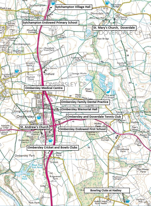
Policy TOAD4: Community facilities
Development proposals that would result in the loss of existing community facilities will
only be supported when the criteria in policy SWDP 37B or its successor can be shown to
be met.
The community facilities covered by this policy are:
1. Ombersley Memorial Hall
2. Sytchampton Village Hall
3. St. Andrew’s Church, Ombersley
4. St. Mary’s Church, Doverdale
5. Ombersley Endowed First School
6. Sytchampton Endowed Primary School
7. Ombersley Family Dental Practice
8. Ombersley Medical Centre
9. Ombersley and Doverdale Tennis Club
10. Ombersley Cricket and Bowls Clubs
11. Bowling Clubs at Hadley.
6.12 Community facilities contribute to the quality of life in the Neighbourhood Area, meeting a
wide variety of educational, religious, health and wellbeing, and community needs and
requirements. It is important in sustaining the social fabric of the parish that they are
retained.
6.13 SWDP 37 Built Community Facilities supports the provision of new facilities and the
enhancement of existing provision, and sets out criteria which must be met by any proposals
that would result in the loss of a site or building currently or last used as a community facility.
Policy TOAD4 lists the community facilities in the Neighbourhood Area to be considered under
these criteria, and they are
shown on Plan 4. It applies to
both the buildings and formal
sport pitches and courts
concerned and associated areas
of land and car parking. The
cricket pitch and bowling green
at Ombersley are also
significant green spaces and are
protected by policy TOAD8.
Ombersley and Doverdale Neighbourhood Development Plan · Submission draft · February 2021 27© Crown copyright and database rights (2019) Ordnance Survey (0100055485). Not to scale.
Plan 4: Location of community facilities
Ombersley and Doverdale Neighbourhood Development Plan · Submission draft · February 2021 28Local retail and other services
Policy TOAD5: Local retail and service facilities
Proposals for new or expanded convenience retail or other similar services to meet day-
to-day needs will be supported provided that they:
1. are of a scale which is proportionate to local community needs; and
2. make full use of opportunities to provide access by walking, cycling or public
transport; and
3. do not result in additional on-road parking, and avoid undue impact on residential
and visual amenity.
Wherever possible, use should be made of sites which are within or physically well-
related to Ombersley, and of existing buildings and previously-developed land in
preference to new development on greenfield sites.
6.14 A key theme arising from the household survey was the desire for additional local services to
meet the daily shopping and other needs of the community. There was considerable support
for more shops with comments also raising the need for a Post Office15 as well as for other
local services such as a bakery and cashpoint. Whilst these are dependent on commercial
decisions, the NDP can provide a positive planning policy, giving confidence that any such
appropriate provision will be readily supported when the planning criteria set out are met.
6.15 At present, retail and service facilities are to be found in either Ombersley or along the A449
and A4133. As Ombersley is a Category 1 village in the SWDP where new housing is proposed,
it is logical that new shops and other services should if possible be provided here in the first
instance. This will help enable the community’s day-to-day requirements to be met in as
sustainable a fashion as possible, by being
relatively accessible by foot, cycle or by
public transport instead of by private car.
Where parking is required, this should be
off-road. There is a shortage of on-road
parking in the centre of Ombersley and it is
important that new shops or services do not
exacerbate the existing situation.
15
The Post Office in Ombersley village closed in 2004. Calls for its re-introduction were the principal finding
from the Parish Plan survey in 2009, and it remains an issue of concern to many. It is addressed in a
Community Action.
Ombersley and Doverdale Neighbourhood Development Plan · Submission draft · February 2021 297. NATURAL ENVIRONMENT
Landscape and biodiversity
Policy TOAD6: Landscape and biodiversity
Development proposals should protect, conserve and enhance landscape character and
contribute to securing net gains for biodiversity by:
1. demonstrating that the character of the landscape has positively influenced the
siting, scale, layout, landscaping and boundary treatment of the proposal; and
2. retaining, conserving and where possible enhancing existing site features of
importance to landscape character and/or biodiversity, including woodland, trees,
hedgerows, traditional orchards, watercourses and ponds; and
3. incorporating new landscaping which serves to maintain and wherever possible
enhance landscape character and biodiversity. New planting should favour native
species, and arrangements should be made for the future maintenance of the
landscaping scheme; and
4. making full use of the available opportunities to improve biodiversity including by
fostering resilient and coherent ecological networks which serve to link the site to
its surroundings.
7.1 The Neighbourhood Area is situated in the valley of the River Severn, an extensive, open and
low-lying agricultural landscape. A characteristic scattered mosaic of hedgerow trees, small
areas of deciduous woodland, traditional orchards, parkland and remnant areas of ancient
and semi-natural woodland contribute to a well-wooded appearance.16
7.2 The Worcestershire Landscape Character
Assessment (LCA) identifies four main
landscape types in the Neighbourhood Area.17
The landscape west of the A449 and north of
the A4133 around the Hamptons is typical of
Principal Settled Farmlands, the rolling
agricultural landscapes of the central part of
the County, with scattered woodland
including Millhampton Wood.
16
See Natural England, National Character Area profile 106: Severn and Avon Vales, 2014.
17
Worcestershire County Council, Landscape Character Assessment and Supplementary Guidance, 2012. The
LCA interactive map and details of the landscape types can be accessed at
http://www.worcestershire.gov.uk/info/20014/planning/1006/landscape_character_assessment
Ombersley and Doverdale Neighbourhood Development Plan · Submission draft · February 2021 307.3 To the east of the A449 lie Principal Timbered Farmlands, rolling lowland landscapes with
occasional steep sided hills and low escarpments. As well as woodland associated with
watercourses such as along the Hadley Brook south of Doverdale, it also includes Knight’s
Grove north of Chatley, the largest area of ancient replanted/semi-natural woodland in the
Neighbourhood Area.
7.4 Estate Farmlands are ordered agricultural landscapes characterised by medium to large sized
fields, small woodland plantations and groups of ornamental trees associated with large
country houses. This describes the landscape west of the A449 and south of the A4133, such
as that surrounding the grade II registered park and garden at Ombersley Court.
7.5 Finally, Riverside Meadows lie alongside the Rivers Severn and Salwarpe on the western and
southern boundaries of the Neighbourhood Area respectively.
7.6 Hedgerows and hedgerow trees are important to the character of all these landscape types,
but they are at risk from loss and deterioration as the growth in arable farming has reduced
their functional value. This threatens the contribution that hedgerows make to landscape
scale and their role as wildlife corridors. To counter this trend, it is important that
development is sited and designed such that it will not require or lead to the removal of
hedgerows or compromise the integrity of the hedgerow network through fragmentation.
Existing hedgerows should be restored and strengthened, and new ones planted wherever
possible, making use of native species to support local biodiversity and maintain landscape
character. Hedgerows are the preferred form of boundary treatment over other means such
as fencing which tend to be both uncharacteristic and urbanising.
7.7 As well as hedgerows, areas of woodland are a feature of the landscape of the Neighbourhood
Area and are also of biodiversity value. Wherever possible, such tree cover should be
conserved and enhanced. Opportunities for new woodland planting which may arise through
development should reflect the scale, shape and composition of the existing woodland
character.
7.8 The main areas of woodland are designated at County-level as Local Wildlife Sites, together
with other local habitats including the
River Severn. Local Wildlife Sites and a
range of other habitats are protected
under SWDP 22 Biodiversity and
Geodiversity. SWDP 25 Landscape
character draws on the County Landscape
Character Assessment to provide an
overall approach. Policy TOAD6 applies
these policies to the Neighbourhood Area
by focussing on aspects such as woodland
that warrant attention in the local
context. River Severn looking south from Holt Fleet Bridge
Ombersley and Doverdale Neighbourhood Development Plan · Submission draft · February 2021 317.9 Protecting the overall character of the landscape of Ombersley and Doverdale was seen as a
priority in the household survey, being sought by 47% of respondents. Specific landscape
features such as trees, hedgerows and woodland were also regarded as priorities for
protection (by 56% of respondents), and 38% wanted to see wildlife habitats and biodiversity
conserved and enhanced. As well their landscape and biodiversity value, natural features also
often have historic and cultural significance. For instance, surviving traditional orchards are
reminders of the importance of fruit cultivation in a previous agricultural economy.
Millennium Orchard
Ombersley and Doverdale Neighbourhood Development Plan · Submission draft · February 2021 32Landscape vistas
Policy TOAD7: Landscape vistas
To be supported development proposals must demonstrate that they are sited, designed
and of a scale such that they do not substantially harm the landscape vistas identified in
Table 1 and on Plan 5.
7.10 An important part of recognising the intrinsic character and beauty of the countryside is to
acknowledge and protect the part played by vistas of the wider landscape. The household
survey identified longer-distance views to the Malvern, Abberley and Clent Hills; across the
Severn valley; and of the wider countryside and across the villages throughout the
Neighbourhood Area as worthy of consideration.
7.11 A web-based survey undertaken for the NDP sought opinion on 14 vistas. They are all locally
valued and are identified here for protection. They are listed below and shown on Plan 5 and
the accompanying photographs.
Ref Name OS grid reference Direction of
(all on sheet SO) view
LV1 Ombersley from Appletree Walk 8383 6428 South east
LV2 Abberley Hills from Millhampton Wood 8302 6521 West
LV3 Malvern from Bill Arnold’s Field, Uphampton 8301 6460 South west
LV4 Snow scene to Malvern Hills 8309 6442 South west
LV5 Ombersley Court from Turn Mill Lane 8391 6357 East
LV6 Holt Castle and Church from Turn Mill Lane 8389 6354 South
LV7 Gardner’s Grove from Haye Lane 8590 6407 South
LV8 Haye Lane and Northampton from Gardner’s Grove 8538 6363 North west
LV9 St Andrew’s and Abberley from Gardner’s Grove 8538 6363 South west
LV10 Abberley Clock Tower from Gardner’s Grove 8538 6363 West
LV11 Malvern Hills from Boreley Lane 8255 6445 South west
LV12 Woodhall Lane Bank, Uphampton 8383 6452 West
LV13 Ombersley from Uphampton 8392 6440 South east
LV14 South to the Malverns from Ombersley Court 8422 6334 South
Table 1: Landscape vistas
Ombersley and Doverdale Neighbourhood Development Plan · Submission draft · February 2021 33You can also read