Local Plan for Slough Slough Borough Council
←
→
Page content transcription
If your browser does not render page correctly, please read the page content below
Local Plan for Slough
Slough Borough Council
STRATEGIC FLOOD RISK ASSESSMENT
LEVEL 1

March 2021
DRAFT Revision 4

Planning Policy and Projects
Slough Borough Council
Observatory House
25 Windsor Road,
Slough,
SL1 2EJ

Phone: 01753 477340

Email: planningpolicy@slough.gov.uk

                                      DRAFT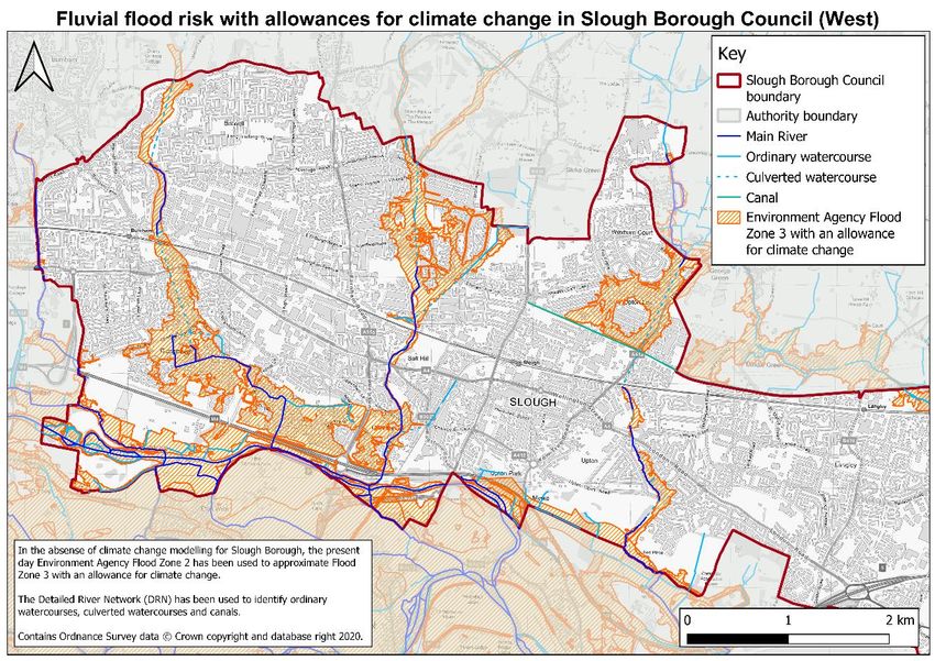
Contents

Chapter                                                                            Page
Glossary                                                                                5
Abbreviations                                                                           5
Definitions                                                                             6
Executive summary                                                                      10
1.       Introduction                                                                  11
1.1.     Purpose of the SFRA                                                           11
1.2.     Approach to strategic flood risk management                                   12
2.       Study area                                                                    14
2.1.     Local Planning Authority area                                                 14
2.2.     Topography                                                                    14
2.3.     Geology                                                                       15
2.4.     Hydrogeology                                                                  17
2.5.     Watercourses                                                                  17
3.       Policy and flood risk responsibility                                          26
3.1.     National legislation                                                          26
3.2.     National policy                                                               26
3.3.     Regional policy                                                               30
3.4.     Local policy                                                                  30
3.5.     Risk Management Authorities                                                   33
3.6.     Consultation                                                                  33
4.       SFRA approach                                                                 34
4.1.     Sequential Test                                                               34
4.2.     Flood Zones                                                                   34
4.3.     Land use vulnerability                                                        35
4.4.     Exception Test                                                                36
5.       Flood risk in Slough                                                          37
5.1.     Data collection                                                               37
5.2.     Historic flood risk                                                           38
5.3.     Present day flood risk                                                        46
5.4.     Flood defences                                                                57
5.5.     Climate change                                                                59
6.       Managing Flood Risk in the Slough Borough                                     62
6.1.     Recommendations for locating future development in the Slough Borough         62
6.2.     Flood Alleviation Schemes                                                     64
6.3.     Emergency Planning                                                            64
6.4.     Flood warning and evacuation plans                                            65
6.5.     Flood warnings                                                                65
7.       Site specific flood risk assessments                                          68
7.1.     When is a site specific FRA required?                                         68
7.2.     How detailed should a site specific FRA be?                                   68
7.3.     Pre-application advice                                                        69
7.4.     Information available to inform a site-specific FRA                           69
7.5.     Approach to a site-specific FRA                                               70

                                                      DRAFT
SFRA Revision 4 | 1.0 | March 2021                                               Page 2 of 85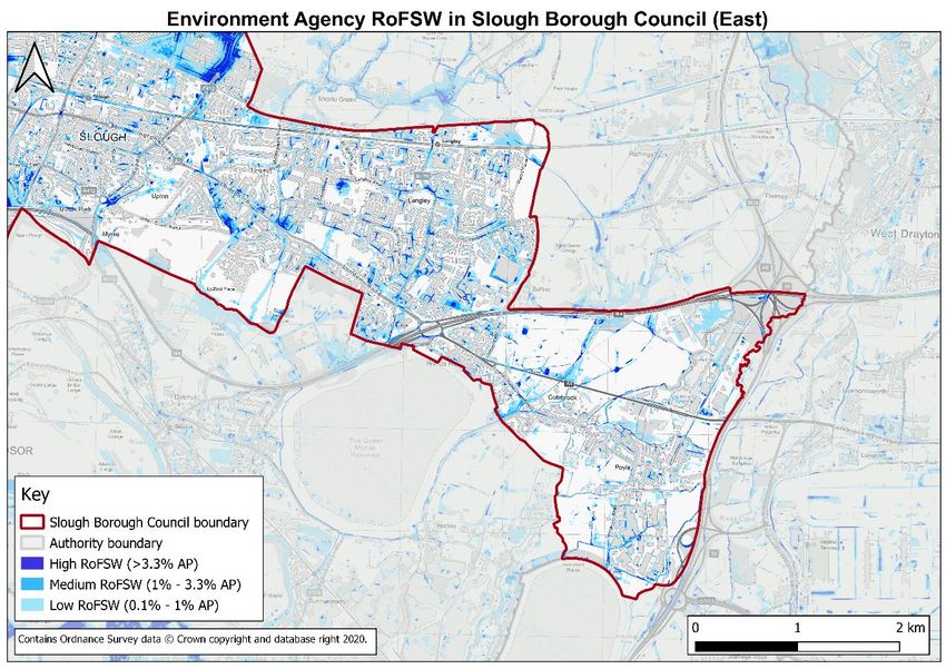
8.       Surface water drainage requirements                                   75
8.1.     Drainage Strategies                                                   75
8.2.     Sustainable Drainage Systems                                          75
9.       Key development sites in the Local Plan: Flood risk assessments       78
10.      Conclusions                                                           79
10.1.    Sources of flood risk                                                 79
10.2.    Development                                                           80
10.3.    Site Specific Flood Risk Assessment                                   80
10.4.    Surface water management                                              80
10.5.    Recommendations                                                       81
11.      References                                                            82
Appendix A.         High resolution mapping                                    85

                                                DRAFT
SFRA Revision 4 | 1.0 | March 2021                                         Page 3 of 85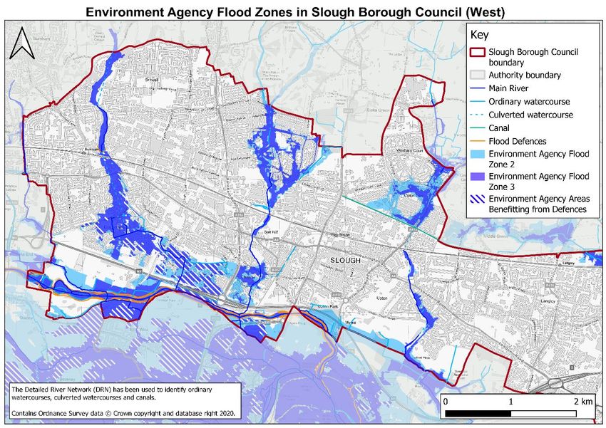
Tables
Table 1 - Watercourses within the Slough Borough 19
Table 2 - Peak river flow allowances by river basin district (based on a 1961 to 1990 baseline) (Environment
Agency, 2020 a) 28
Table 3 - Peak rainfall intensity allowance in small catchments (less than 5 km2) or urban drainage catchments
(based on a 1961 to 1990 baseline) (Environment Agency, 2020 a). 30
Table 4 – Responsibilities of RMAs in the Slough Borough 33
Table 5 - Flood Zones (Ministry of Housing, Communities & Local Government, 2016) 35
Table 6 – Flood risk vulnerability classification (Ministry of Housing, Communities & Local Government, 2016)
35
Table 7 - Flood risk vulnerability and Flood Zone ‘compatibility’ (Ministry of Housing, Communities & Local
Government, 2016) 36
Table 8 – Flood sources in SBC 37
Table 9 - Data sources 37
Table 10 – Historic flood incidents in the Slough Borough 40
Table 11 – Flood risk considerations for development within Environment Agency Flood Zones 62
Table 12 – Environment Agency flood alert and warning areas 66
Figures
Figure 1 - Location map of the Slough Borough Council boundary 14
Figure 2 – Topography map of Slough 15
Figure 3 - Bedrock geology (British Geological Survey, 2019) 16
Figure 4 - Superficial deposits (British Geological Survey, 2019) 16
Figure 5 - Watercourses in the Slough Borough 18
Figure 6 - Catchments in the Slough Borough 18
Figure 7 – Recorded Historic Flooding in the Slough Borough 39
Figure 8 – Thames Water recorded historic sewer flooding in the Slough Borough 45
Figure 8 - Environment Agency Flood Zones in Slough Borough Council (West) 47
Figure 9 - Environment Agency Flood Zones in Slough Borough Council (East) 47
Figure 10 - Flood Zone 3b delineation in Slough Borough Council (West) 48
Figure 11 - Flood Zone 3b delineation in Slough Borough Council (East) 49
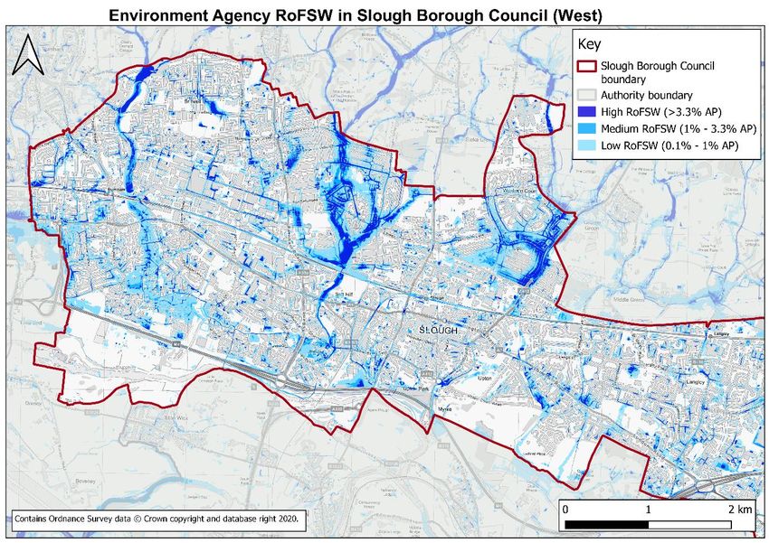
Figure 12 - Environment Agency RoFSW in Slough Borough Council (West) 50
Figure 13 - Environment Agency RoFSW in Slough Borough Council (East) 50
Figure 14 – CDAs in Slough Borough Council (West) 51
Figure 15 - CDAs in Slough Borough Council (East) 52
Figure 16 - BGS Susceptibility to Groundwater Flooding 53
Figure 17 - Environment Agency Risk of Flooding from Reservoirs in Slough Borough Council (West) 56
Figure 18 - Environment Agency Risk of Flooding from Reservoirs in Slough Borough Council (East) 56
Figure 19 - Flood defences and assets 57
Figure 20 - Fluvial flood risk with allowances for climate change in Slough Borough Council (West) 60
Figure 21 - Fluvial flood risk with allowances for climate change in Slough Borough Council (East) 60
Figure 22 - Environment Agency Flood Warning and Alert Areas 67
Figure 23 - Environment Agency SPZs 77
DRAFT
SFRA Revision 4 | 1.0 | March 2021 Page 4 of 85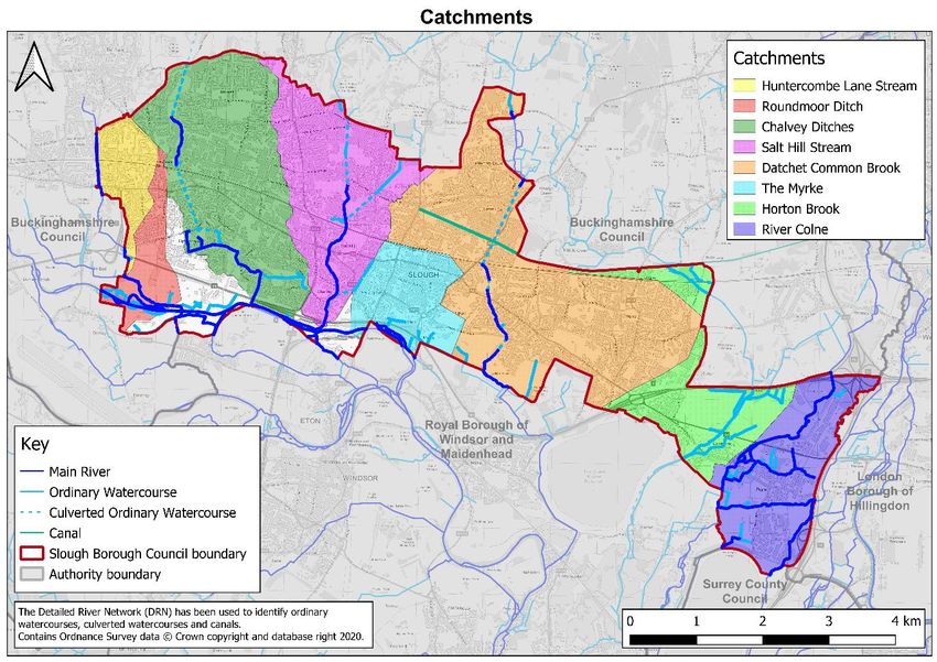
Glossary
Abbreviations
 Term                      Definition
 AP                        Annual probability
 BGS                       British Geological Survey
 CDA                       Critical drainage area
 CFMP                      Catchment flood management plan
 Defra                     Department for Environment, Food and Rural Affairs
 DRN                       Detailed river network
 DTM                       Digital terrain model
 FCERM                     Flood and coastal erosion risk management
 FEH                       Flood Estimation Handbook
 FRA                       Flood risk assessment
 FRMP                      Flood risk management plan
 GIS                       Graphical information systems
 IDB                       Internal Drainage Board
 LDF                       Local Development Framework
 LiDAR                     Light detection and ranging
 LLFA                      Lead Local Flood Authority
 LFRMS                     Local flood risk management strategy
 LPA                       Local Planning Authority
 NPPF                      National Planning Policy Framework
 PPG                       Planning practice guidance
 NRD                       National receptor database
 OS                        Ordnance Survey
 RMA                       Risk Management Authority
 RoFSW                     Risk of flooding from surface water
 SBC                       Slough Borough Council
 SFRA                      Strategic flood risk assessment
 SPZ                       Source protection zone
 SuDS                      Sustainable drainage systems
 SWMP                      Surface water management plan
 uFMfSW                    Updated flood map for surface water

                                                    DRAFT
SFRA Revision 4 | 1.0 | March 2021                                              Page 5 of 85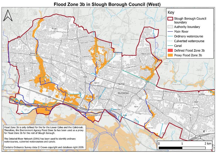
Term                      Definition
 UKCP18                    UK Climate Projections 2018

Definitions
 Term                      Definition
 Aquifer                   An area of permeable rock underground which absorbs and holds
                           groundwater.
 Areas with                Environment Agency defined areas that have critical drainage problems.
 critical drainage
 problems
 Brownfield site           A previously developed parcel of land.
 Bedrock                   Main mass of rocks forming the Earth. These might be exposed at the
                           surface or concealed by either water or superficial deposits.
 Canal flooding            Flooding from canals following bank overtopping or breaching.
 Climate change            Climate change is widely regarded as the most serious environmental
                           challenge facing us in the 21st century. Increasing amounts of
                           greenhouse gases being released into the atmosphere are helping to
                           trap more heat in, making the planet warmer than it should be. This is
                           likely to result in increased risk of flooding.
 Critical drainage         An area within Environment Agency defined Flood Zone 1, which has
 area                      critical drainage problems.
 Exception Test            Demonstrates how flood risk will be managed on a proposed
                           development site. For the Exception Test to be passed, the
                           sustainability benefits need to outweigh the flood risk.
 Flood Zone                Environment Agency classified Flood Zone that refers to the probability
                           of flooding from rivers or the sea, ignoring the presence of defences.
                           Flood Zones do not take account of climate change.
 Flood Zone 1              “Low probability”. Land having a less than 1 in 1,000 AP of river
                           flooding.
 Flood Zone 2              “Medium probability”. Land having between a 1 in 100 and 1 in 1,000
                           AP of river flooding.
 Flood Zone 3a             “High probability”. Land having a 1 in 100 or greater AP of river flooding.
 Flood Zone 3b             “High probability”. This zone comprises land where water flows or is
                           stored in times of flood.
 Fluvial flooding          Exceedance of the flow capacity of river channels, leading to
                           overtopping of the riverbanks and inundation of the surrounding land.
                           Climate change is expected to increase the risk of fluvial flooding in the
                           future.
 Functional                Land where water flows or is stored in times of flood.
 floodplain
                                                   DRAFT
SFRA Revision 4 | 1.0 | March 2021                                                             Page 6 of 85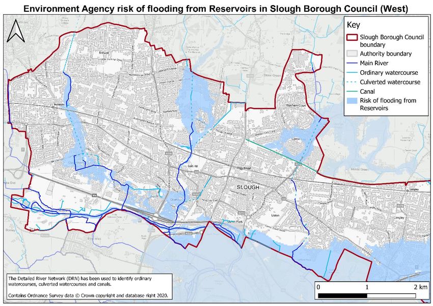
Term                      Definition
 Green Belt                Defined areas of open land surrounding a city. Building is restricted in
                           this area.
 Greenfield site           A previously undeveloped parcel of land.
 Groundwater               Emergence of groundwater at the surface (and subsequent overland
 flooding                  flows) or into subsurface voids as a result of abnormally high
                           groundwater flows, the introduction of an obstruction to groundwater
                           flow and / or the rebound of previously depressed groundwater levels.
 Lead Local                As defined by the Flood and Water Management Act (2010), Slough
 Flood Authority           Borough Council as LLFA are responsible for developing, maintaining
 (LLFA)                    and applying a strategy for local flood risk management.
                           A LLFA must maintain a register of their flood risk assets and has a duty
                           in investigate flood incidents to the extent that it considers it necessary
                           or appropriate.
                           The LLFA are responsible for flooding from surface water, groundwater
                           and Ordinary Watercourses.
 Local Planning            The public authority responsible for controlling planning and
 Authority (LPA)           development through the planning system.
 Main River                Main Rivers are usually larger rivers and streams. The Environment
                           Agency carries out maintenance, improvement or construction work on
                           Main Rivers to manage flood risk.
 Major                     A major development involving any one or more of the following:
 development                  • The provision of residential property where:
                                    o the number of residential properties to be provided is 10 or
                                       more; or
                                    o the development is to be carried out on a site having an
                                       area of 0.5 hectares or more and the number of residential
                                       properties is unknown.
                              • The provision of non-residential property where the floor space
                                 created by the development is equal to or greater than 1,000
                                 square metres;
                              • Non-residential development on a site with an area equal to or
                                 greater than 1 hectare;
                              • The winning and working of minerals or the use of land for
                                 mineral-working deposits; or
                              • Waste development.
 Minor                     A minor development involves:
 development                  • Provision of residential property where:
                                    o the number of residential properties to be provided is
                                       between 1 and 9 inclusive; or

                                                   DRAFT
SFRA Revision 4 | 1.0 | March 2021                                                            Page 7 of 85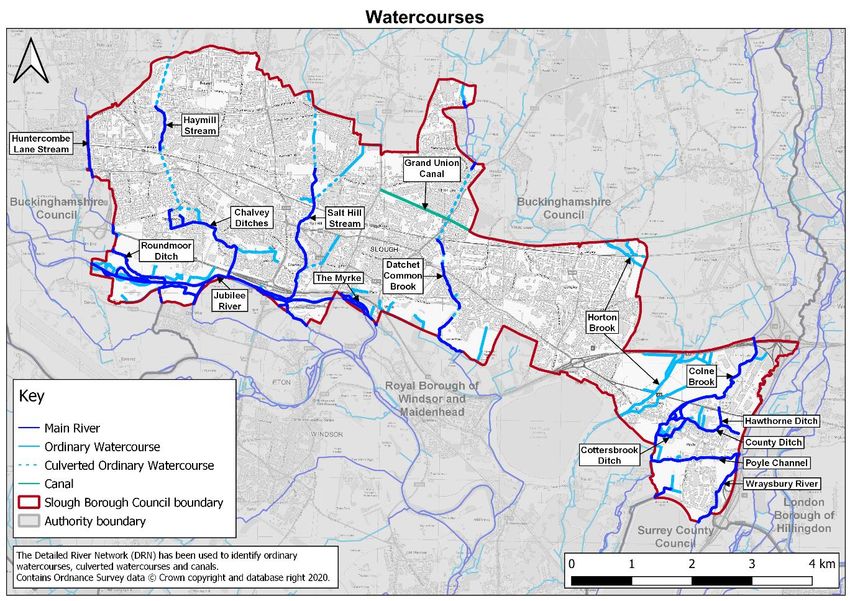
Term                      Definition
                                     o the development is to be carried out on a site having an
                                        area less than 0.5 hectares where the number of
                                        residential properties is unknown.
                              • The provision of non-residential property where the floor space
                                  created by the development is less than 1,000 square metres: or
                              • Non-residential development on a site with an area less than 1
                                  hectare.
 Ordinary                  Ordinary Watercourses are watercourses that are not classified as an
 Watercourse               Environment Agency Main Rivers. The Lead Local Flood Authority
                           carries out maintenance, improvement or construction work on Main
                           Rivers to manage flood risk.
 Penstock                  A sluice or a gate that controls water flow.
 Principal aquifer         “These are layers of rock or drift deposits that have high intergranular
                           and/or fracture permeability - meaning they usually provide a high level
                           of water storage. They may support water supply and/or river base flow
                           on a strategic scale. In most cases, principal aquifers are aquifers
                           previously designated as major aquifer.” (Environment Agency, 2017).
 Reservoir                 Flooding from reservoirs following embankment overtopping or
 flooding                  breaching.
 Riparian owner            Someone who owns a property where there is a watercourse within or
                           adjacent to the boundaries of their property and a watercourse.
 Secondary A               “permeable layers capable of supporting water supplies at a local rather
 aquifer                   than strategic scale, and in some cases forming an important source of
                           base flow to rivers. These are generally aquifers formerly classified as
                           minor aquifers” (Environment Agency, 2017).
 Sequential Test           The Sequential Test aims to steer vulnerable development to the areas
                           of lowest flood risk.
 Sewer flooding            Flooding from sewers is caused by exceedance of sewer capacity and /
                           or blockages in the sewer network.
 Siphon                    A “U” shaped pipe which allows water to flow uphill without being
                           pumped. A siphon can be used to allow one river to cross and flow
                           under another.
 Source                    Source protection zones are defined for groundwater sources such as
 protection zone           boreholes, wells or springs used for drinking water supply. They show
 (SPZ)                     the risk of contamination from any activities that might cause pollution in
                           the area.
 Surface water             Intense rainfall exceeds the available infiltration capacity and / or the
 flooding                  drainage capacity leading to overland flows and surface water flooding.
                           Climate change is expected to increase the risk of surface water
                           flooding in the future.
 Superficial               Younger rocks which sit on bedrock.
 deposits
                                                   DRAFT
SFRA Revision 4 | 1.0 | March 2021                                                            Page 8 of 85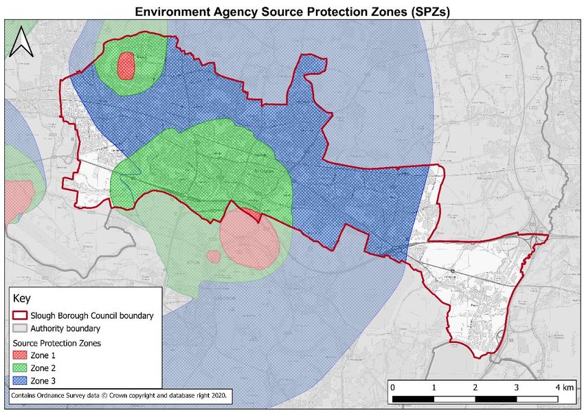
Term                      Definition
 Sustainable               Drainage systems that manage water in a sustainable way and have
 Drainage                  multiple environmental benefits.
 Systems
 (SuDS)

                                                 DRAFT
SFRA Revision 4 | 1.0 | March 2021                                                     Page 9 of 85
Executive summary
As the Local Planning Authority (LPA), Slough Borough Council (SBC) has the responsibility,
in accordance with the National Planning Policy Framework (NPPF) (Ministry of Housing,
Communities and Local Government, 2019) to ensure that flood risk is understood and
managed effectively through the planning process.
In 2008 SBC published a strategic flood risk assessment (SFRA) to address flood risk within
the Borough, this was then updated in 2009 and then 2012. Since this time national flood
management policy and flood risk mapping has been updated and hence a SFRA update is
required. The aim of this updated Strategic Flood Risk Assessment (SFRA) is to:
    •    Inform the sustainability appraisal of the Local Plan so that flood risk is taken into
         account when assessing allocation options and in the preparation of plan policies,
         including policies for flood risk management to ensure that flood risk is not increased;
    •    Ensure that the allocation of land within the Local Plan is made based on an
         appropriately detailed assessment of flood risk. This should include the Sequential
         Test, and where necessary the Exception Test from the NPPF (Ministry of Housing,
         Communities and Local Government, 2019);
    •    Ensure the formulation of appropriate development control policies for managing flood
         risk (from all sources) in the Slough Borough;
    •    Identify the level of detail required for site specific flood risk assessments (FRAs) and
         for surface water drainage schemes;
    •    Determine the acceptability of flood risk in relation to emergency planning capability;
         and
    • Inform the Sequential Test for windfall housing sites.
This revised SFRA provides an overview of the risk of flooding from all sources across the
Slough Borough including flooding from rivers, surface water, groundwater, sewers and other
sources. This SFRA will provide part of the evidence base for the new Local Plan and
allocation of development sites.
Flood risk information is continuously being updated; this SFRA has been developed using
the best available data at the time of preparation. The SFRA should be updated when
appropriate; for example, when new information on flood risk, flood warnings, planning
guidance or legislation is made available.

                                               DRAFT
SFRA Revision 4 | 1.0 | March 2021                                                       Page 10 of 85
1. Introduction
The Slough Borough is at risk of multiple sources of flooding. In recent years, it has
experienced flooding from rivers (fluvial), surface water, groundwater and sewers. This
needs to be taken into account when considering future development within the Slough
Borough.
This level 1 strategic flood risk assessment (SFRA) provides a detailed assessment of flood
risk within the administrative area of Slough Borough Council (SBC). All sources of flooding
are considered and information on historic flooding is provided where available and
applicable.
This SFRA has been prepared in accordance with the National Planning Policy Framework
(NPPF) (Ministry of Housing, Communities and Local Government, 2019) and associated
planning practice guidance (PPG) (Ministry of Housing, Communities & Local Government,
2016) on flood risk. The SFRA is also in accordance with the latest Environment Agency
guidance on climate change (Environment Agency, 2020 a).
Since the previous SFRA was published in 2012, a number of changes in planning policy
have occurred. Furthermore, updated datasets have been made available, including
improvements to flood mapping. This SFRA incorporates all these changes and updates.
The Environment Agency and Thames Water are currently being consulted; this document
will be updated following the consultation.
Regarding the purpose of the SFRA in relation to the Local Plan the Council is currently
preparing a new Local Plan for Slough. This SFRA will provide part of the evidence base for
the Local Plan and allocation of development sites.
1.1. Purpose of the SFRA
The purpose of the level 1 SFRA is to collate, analyse and present the most up to date flood
risk information for the Slough Borough to:
• Inform the sustainability appraisal of the Local Plan so that flood risk is taken into
account when assessing allocation options and in the preparation of plan policies,
including policies for flood risk management to ensure that flood risk is not increased;
• Ensure that the allocation of land within the Local Plan is made based on an
appropriately detailed assessment of flood risk. This should include the Sequential
Test, and where necessary the Exception Test from the NPPF (Ministry of Housing,
Communities and Local Government, 2019);
• Ensure the formulation of appropriate development control policies for managing flood
risk (from all sources) in the Slough Borough;
• Identify the level of detail required for site specific flood risk assessments (FRAs) and
for surface water drainage schemes;
• Determine whether any level 2 SFRAs are required, or whether any surface water
management plans (SWMPs) would be recommended;
• Determine the acceptability of flood risk in relation to emergency planning capability;
and
• Inform the Sequential Test for windfall housing sites.
DRAFT
SFRA Revision 4 | 1.0 | March 2021 Page 11 of 851.2. Approach to strategic flood risk management
The NPPF (Ministry of Housing, Communities and Local Government, 2019) and associated
PPG (Ministry of Housing, Communities & Local Government, 2016) on flood risk highlight
the active role the Local Planning Authority (LPA) should take with regards to flood risk. The
overall approach for the consideration of flood risk has three key elements:
1. Assess flood risk;
a. Undertake a SFRA to fully understand local flood risk and to inform the
preparation of the Local Plan; and
b. In areas at risk of flooding or for sites of 1 hectare or more, developers
undertake a site-specific flood risk assessment to accompany applications for
planning permission.
2. Avoid flood risk; and
a. SBC should apply the sequential approach to development site selection. As
far as reasonably possible, development should be located where the risk of
flooding (from all sources) is lowest, taking account of climate change and the
vulnerability of future uses to flood risk;
b. A sequential approach, and where necessary the Exception Test, should be
applied to the Local Plan; and
c. A Sequential Test for individual development proposals, and where necessary
the Exception Test, should be applied to specific development proposals.
3. Manage and mitigate flood risk.
a. When development needs to be in areas at flood risk, the development should
be flood resilient and resistant and safe for its users for the development’s
lifetime, including a changing climate;
b. Development should not increase flood risk overall or to third party land; and
c. Flood risk management opportunities should be sought as well as ways to
reduce the causes and impacts of flooding (e.g. using sustainable drainage
systems (SuDS)).
This SFRA does not reproduce all the guidance from the NPPF (Ministry of Housing,
Communities and Local Government, 2019) and thus, the NPPF, together with the PPG
(Ministry of Housing, Communities & Local Government, 2016) should be read in conjunction
with this SFRA.
SBC has worked closely with the Environment Agency (the principal flood risk management
operating authority in England empowered under the Water Resources Act 1991 to manage
flood risk arising from designated "main" rivers and the sea) on strategic fluvial flooding in
the Slough Borough. SBC work with neighbouring authorities to ensure that proposals and
developments in those districts do not have an adverse impact on the Slough Borough, and
vice versa. SBC work with Thames Water, the local water company, to ensure proposals and
developments do not have an adverse impact on the capacity of the sewer network in the
Slough Borough.
This assessment has now been updated to reflect changes which have occurred since 2012.
All figures within the SFRA have been appended in high resolution in Appendix A.
This SFRA will be subject to further amendments when appropriate to reflect future changes
in planning policy or available data, including:
• Flood map up-dates/new detailed modelling of the Salt Hill Stream by Atkins Limited;
DRAFT
SFRA Revision 4 | 1.0 | March 2021 Page 12 of 85• Flood events which provide new information/data/flood outlines; and
• Relevant changes in national policy and legislation.
DRAFT
SFRA Revision 4 | 1.0 | March 2021 Page 13 of 852. Study area
2.1. Local Planning Authority area
Slough Borough (Figure 1) is situated to the west of London in the Thames Valley, with the
administrative boundaries of Buckinghamshire Council to the north and west, London
Borough of Hillingdon to the east and Surrey County Council and the Royal Borough of
Windsor and Maidenhead to the south. Slough is a small Borough of just 32.5 km2. It is
densely built up, with an area of Green Belt located south of the M4.
The A4 runs through the length of the Slough Borough with the M4 motorway running
parallel along the south of the Slough Borough. The M25 runs north-south along the eastern
boundary. Heathrow airport also lies just to the east of the Slough Borough boundary.
Figure 1 - Location map of the Slough Borough Council boundary
See Appendix A for high resolution version of Figure 1.
2.2. Topography
As shown on Figure 2, the Slough Borough is situated on two terraces, the upper terrace and
the river terrace. The land slopes from north to south, and west to east. The Thames Valley
runs west/east along the southern boundary and the Lower Colne valley north/south through
the Colnbrook and Poyle area. In addition, the Slough Borough is cut north/south by a
number of watercourse valleys, more information on these watercourses is provided in
Section 2.5. Due to the topography of Slough, parts of the Borough are at significant risk of
surface water flooding, as water flows south where it then sits on the relatively flat upper
terrace.
DRAFT
SFRA Revision 4 | 1.0 | March 2021 Page 14 of 85Figure 2 – Topography map of Slough
See Appendix A for high resolution version of Figure 2.
2.3. Geology
Although the Slough Borough is a small, compact area extending seven miles east to west
and three miles north to south, the underlying geology is complex and varied. The bedrock
and superficial deposit types are outlined below, using British Geological Survey (BGS) data
(British Geological Survey, 2019). The boundaries between the various areas of bedrock and
superficial deposits as shown on the BGS maps are by no means precise; the BGS maps
are updated as new information becomes available and hence the geology discussed here is
liable to change.
2.3.1. Bedrock
The bedrock (as shown in Figure 3) is mainly comprised of Clay Silt and Sand from the
London Clay formation and the Lambeth Group. There is a small area comprised of Seaford
Chalk Formation and Newhaven Chalk formation to the North West of the Borough.
2.3.2. Superficial deposits
The superficial deposits (as shown on Figure 4) also vary across the Slough Borough. There
is a large band of Langley Silt (Clay and Silt) across the northern part of the borough,
changing to Taplow Gravel (sand and Gravel) and then Alluvium (Clay, Silt, Sand and
Gravel) as distance from the River Thames decreases. There are also small areas around
the Borough of Shepperton Gravel (Sand and Gravel). There are only very small areas
containing no superficial deposits.
DRAFT
SFRA Revision 4 | 1.0 | March 2021 Page 15 of 85Figure 3 - Bedrock geology (British Geological Survey, 2019)
See Appendix A for high resolution version of Figure 3.
Figure 4 - Superficial deposits (British Geological Survey, 2019)
See Appendix A for high resolution version of Figure 4.
DRAFT
SFRA Revision 4 | 1.0 | March 2021 Page 16 of 852.4. Hydrogeology
Aquifers are defined as an underground layer of permeable rock, rock fractures or
unconsolidated material (sand, gravel, silt etc.) which can store and transport large quantities
of water. Understanding the location and behaviour of aquifers is important as they can
indicate the potential for groundwater flooding.
The aquifers within the Slough Borough are as follows:
• The Seaford Chalk formation and the Newhaven Chalk formation bedrock that
underlies part of the Burnham area in the Slough Borough (Figure 3) is described by
the Environment Agency as a Principal Aquifer;
• The Shepperton Gravel (sand and gravel) superficial deposits shown in Figure 4 is
described by the Environment Agency as a Principal Aquifer;
• The Lambeth Group (clay, silt and sand) bedrock that underlies the western half of the
Slough Borough (Figure 3) is described by the Environment Agency as a Secondary A
aquifer; and
• The Alluvium (clay, silt, sand and gravel) superficial deposits are described by the
Environment Agency as a Secondary A aquifer.
The Environment agency provides the following definitions:
• Principal Aquifer: “These are layers of rock or drift deposits that have high
intergranular and/or fracture permeability - meaning they usually provide a high level
of water storage. They may support water supply and/or river base flow on a strategic
scale. In most cases, principal aquifers are aquifers previously designated as major
aquifer.” (Environment Agency, 2017).
• Secondary A: “permeable layers capable of supporting water supplies at a local
rather than strategic scale, and in some cases forming an important source of base
flow to rivers. These are generally aquifers formerly classified as minor aquifers”
(Environment Agency, 2017).
See Section 8 for further information relating to groundwater and infiltration issues, and
groundwater source protection zones (SPZs).
2.5. Watercourses
There are a number of watercourses in the Slough Borough (as shown on Figure 5). Many of
these are classified as Main River, which the Environment Agency have permissive powers
to maintain and improve. Others, or parts of some rivers, are classified as Ordinary
Watercourses, for which the Lead Local Flood Authority (LLFA) (SBC) are the operating
authority. Some of the watercourses are not apparent on the ground as substantial sections
have been culverted. The catchment areas are shown in Figure 6. These are indicative
boundaries based upon those delineated in the Flood Estimation Handbook (FEH) online
service. Certain culverted sections are mapped as Thames Water surface water sewers, but
Thames Water dispute their ownership as they are not responsible for watercourse
management. Thames Water are the water and sewerage board for the Slough Borough.
The River Thames itself flows to the south of the Borough, within the Royal Borough of
Windsor and Maidenhead.
An overview of the watercourses within the Slough Borough is given in Table 1.
DRAFT
SFRA Revision 4 | 1.0 | March 2021 Page 17 of 85Figure 5 - Watercourses in the Slough Borough
See Appendix A for high resolution version of Figure 5.
Figure 6 - Catchments in the Slough Borough
See Appendix A for high resolution version of Figure 6.
DRAFT
SFRA Revision 4 | 1.0 | March 2021 Page 18 of 85Table 1 - Watercourses within the Slough Borough
* ‘Catchment size’ is defined as the size of the catchment until there is a confluence or the watercourse leaves the Slough Borough. ‘N/A’
has been used where the river is manmade or where the catchment area is a sub-catchment of another and is included elsewhere.
Approximate
Name Type Location Tributary of catchment Description
size*
Huntercombe Lane Stream and Roundmoor Ditch
The Huntercombe Lane Stream enters the Slough Borough from
Buckinghamshire Council at the junction of Stomp Road and
Huntercombe Lane North. It is culverted for most of its length
within the Slough Borough. The Huntercombe Lane Stream
Huntercom Burnham
Roundmoor leaves the Slough Borough following Huntercombe Lane South,
be Lane Main River (West 2.3 km2
Ditch it then re-enters the Slough Borough at the junction of West Point
Stream Slough)
and Mercian Way. It flows in an open watercourse through the
West Point allotments and south of the M4 motorway. Just south
of the M4 motorway the Huntercombe Stream joins the
Roundmoor Ditch.
The Roundmoor Ditch flows into the Slough Borough, from
Buckinghamshire Council, west of the Thames Water Slough
South-West 11.6 km2 sewage works at its confluence with the Huntercombe Lane
Roundmoo Jubilee
Main River Slough including Stream. It then flows south east, around the sewage works, and
r Ditch River
(rural) Huntercombe is culverted underneath the weir on the Jubilee River before
leaving the Slough Borough and flowing into the Royal Borough
of Windsor and Maidenhead.
Jubilee River
DRAFT
SFRA Revision 4 | 1.0 | March 2021 Page 19 of 85Approximate
Name Type Location Tributary of catchment Description
size*
The Jubilee River is a manmade channel built to reduce the risk
South-West
Jubilee River of flooding by diverting water from the Thames upstream of
Main River Slough N/A
River Thames Maidenhead. The Jubilee re-joins the River Thames downstream
(rural)
of Windsor in the Royal Borough of Windsor and Maidenhead.
Chalvey Ditches
Main River
and Burnham
Haymill Chalvey The upper reaches of the Chalvey Ditches are referred to as the
Ordinary (West N/A
Stream Ditches Haymill Stream or Two-Mile Stream.
Watercour Slough)
se
The Chalvey Ditches enters the Slough Borough from
Buckinghamshire Council. It is culverted through the Lynch Hill
Valley and then flows in open channel from south of Whittaker
Road through the Haymill Valley to Burnham Lane.
In high flows the water ponds behind a structure and dam
Burnham (Haymill Dam) at the junction of Buckingham Avenue and
and Burnham Lane.
Chalvey River
Main River Cippenham 22.9 km2 The Chalvey Ditches is then culverted south towards
Ditches Thames
(West Cippenham. At Cippenham Green, the Chalvey Ditches branch
Slough) into three:
• Mill Stream, the original course, branches off in a culvert
to the west and flows in open channel along part of Lower
Cippenham Lane and south along Mill Stream Lane.
• Most of the flow is passed south through a culvert into an
open watercourse at the south of College Road, through
DRAFT
SFRA Revision 4 | 1.0 | March 2021 Page 20 of 85Approximate
Name Type Location Tributary of catchment Description
size*
Deerwood Park. This joins Mill Stream just south of Earls
Lane.
• The third culvert flows to the east, towards Lower
Cippenham Lane, it then flows in an open channel south
to re-join the Mill Stream.
The Chalvey Ditches is then culverted under the M4 to the east
of Asda supermarket and then flows east alongside the south
side of the M4, under the A355. It is then siphoned under the
Jubilee River and discharges into the River Thames in the Royal
Borough of Windsor and Maidenhead.
Salt Hill Stream
The Salt Hill Stream enters the Slough Borough from
Buckinghamshire Council at the Stoke Poges golf course. It
originates in two tributaries in wooded or rural parts of Farnham
Common and Stoke Poges. The two tributaries meet just south
Main River of the Stoke Poges golf course where they are culverted south.
and Manor Park, The Salt Hill Stream flows in open channel through Granville
Salt Hill River
Ordinary Salt Hill and 16.9 km2 Park and is then culverted again until it reaches Godolphin
Stream Thames
Watercour Chalvey Recreation Ground and Baylis Memorial Gardens. The river is
se then culverted under the railway and then flows in open channel
through Salt Hill Park. Culverted under Bath Road, the Salt Hill
Stream them flows in open channel until it reaches Church
Street, it then flows in both culverts and open channel to the M4,
where it is culvert underneath.
DRAFT
SFRA Revision 4 | 1.0 | March 2021 Page 21 of 85Approximate
Name Type Location Tributary of catchment Description
size*
It is then siphoned under the Jubilee River and discharges into
the River Thames in the Royal Borough of Windsor and
Maidenhead.
Datchet Common Brook
The Datchet Common Brook initially enters the Slough Borough
to the east of Wexham Hospital from Buckinghamshire Council
as an open channel Ordinary Watercourse. It flows through a
ponded area to the north of Wexham Park Lane, approximately
100 m upstream of Wexham Park Lane, the river changes from
an Ordinary Watercourse to a Main River.
South of Wexham Park Lane, the watercourse flows out of SBC,
Main River back into Buckinghamshire Council. The Datchet Common
Datchet and Brook re-enters the Slough Borough near the junction of Church
Wexham River
common Ordinary 14.0 km2 Lane and the Uxbridge Road. The watercourse remains an open
and Upton Thames
brook Watercour channel through the allotments to the south of Church Lane and
se then is culverted most of the way south to Upton Court Park. The
watercourse splits at the London Road with the original route
running as an open watercourse parallel and north of Quaves
Road; it enters a culverted section at Upton Court Road and runs
southwards into Upton Court Park.
The main flow is culverted and mapped as a surface water sewer
under Quaves Road. The two culverts join at a point in Upton
Court Park.
DRAFT
SFRA Revision 4 | 1.0 | March 2021 Page 22 of 85Approximate
Name Type Location Tributary of catchment Description
size*
The Datchet Common Brook then flows out of the Slough
Borough and discharges into the River Thames in the Royal
Borough of Windsor and Maidenhead.
The Myrke
The Myrke catchment covers Slough town centre and south of
the town centre down to the Jubilee River. The catchment drains
Central Jubilee
The Myrke Main River 2.0 km2 Herschel Park and part of Upton Court Park. One ordinary
Slough River
watercourse from Herschel Park and two from Upton Court Park
flow into the Myrke which discharges into the Jubilee River.
Horton Stream
The Horton Brook enters the Slough Borough through a culvert
under the Grand Union Canal from Buckinghamshire Council,
north-east of Langley Station, and flows in an open channel
south eastward. It is culverted under Market Lane and re-enters
Buckinghamshire Council.
Ordinary The Horton Brook re-enters the Slough Borough through a
Horton Langley and
Watercour Colne Brook 17.9 km2 culvert under the M4 motorway, south of Richings Park Golf
Brook Colnebrook
se Club, and flows in an open channel south, culverted under
Colnbrook bypass to Colnbrook High Street where it is culverted
again. The Horton Brook emerges along the side of Crown
Meadow and flows through the meadow and alongside the
Horton Road into the Royal Borough of Windsor and
Maidenhead.
River Colne catchment
DRAFT
SFRA Revision 4 | 1.0 | March 2021 Page 23 of 85Approximate
Name Type Location Tributary of catchment Description
size*
The Colne Brook is a part of the River Colne catchment and runs
Colne Colnbrook from Uxbridge Moor to the River Thames at the downstream
Main River River Colne
Brook and Poyle boundary entering the Thames just below Bell Weir Lock in
Hythe End, Wraysbury.
The Colne Brook leaves the River Colne in the Colne Valley
County Colnbrook Regional Park and then flows south to West Drayton and passes
Main River Colne Brook
Ditch and Poyle under the M25 and M4 where it enters the Slough Borough.
The open channel flows alongside a series of lakes north of the
Colnbrook Bypass. After passing under the Colnbrook Bypass
Hawthorne Colnbrook
Main River Colne Brook 88.3 km2 the channel splits and flows around the east and west side of the
Ditch and Poyle
Tanhouse Farm industrial area.
On the eastern arm the Colne Brook channel is joined by the
Cottersbro Colnbrook County ditch. The inflow into the Colne Brook from the County
Main River Colne Brook Ditch is controlled by a weir. The controls and embankments
ok ditch and Poyle
around this area form part of a flood alleviation scheme installed
by the Environment Agency in the1990s. The County Ditch runs
from the north side of the Colne/Galleymead trading estates and
Poyle
Main River Poyle Colne Brook is joined by the Hawthorn Ditch from the north around Hawthorn
Channel
Avenue.
The Hawthorn Ditch is fed by Colnebrook Water – the discharge
from Colnebrook Water is controlled by a penstock which is
operated by the Environment Agency.
Wraysbury River
Main River Poyle 2.4 km2 The County Ditch can flow into an overflow channel via a
River Thames
lowered embankment at the Albany Park overflow which was
constructed as part of the more recent flood alleviation scheme
in 2004/2005. This overflow channel then connects to the
DRAFT
SFRA Revision 4 | 1.0 | March 2021 Page 24 of 85Approximate
Name Type Location Tributary of catchment Description
size*
Cottersbrooke Ditch which flows south and west and joins the
Colne Brook south of Colnbrook village centre.
The Colne Brook east and west arms join just north of Bridge
Street and flows through the village of Colnbrook. South of
Colnbrook village the Poyle Channel joins the Colne Brook
having flowed through the Poyle industrial area. The Poyle
Channel is an offtake from the Wraysbury River via a weir just
inside the SBC boundary on the west side of the M25. The
Wraysbury River itself branches off the River Colne at West
Drayton. It flows along the west side of the M25 within the
Slough Borough boundary before leaving the Borough by the
Wraysbury reservoir.
Other
The Grand Union Canal is a 137 mile canal from the Tideway
Grand
Central (Thames) at Brentford in London to Birmingham. There is an
Union Canal N/A N/A
Slough arm, that comes off this main line, into the Slough Borough. The
Canal
Slough arm is 4.9 miles long and ends at Stoke Road (B416).
DRAFT
SFRA Revision 4 | 1.0 | March 2021 Page 25 of 853. Policy and flood risk responsibility
The overall aim of development and flood risk planning policy is to make sure that the risk of
flooding is considered at all stages of the planning process. This section of the SFRA
provides a brief overview of national, regional and local planning policy relevant to flood risk
and the preparation of this SFRA. This section also highlights flood risk responsibilities.
3.1. National legislation
3.1.1. Flood and Water Management Act (2010)
The Flood and Water Management Act was enacted in 2010. The key areas within this Act
are the roles and responsibilities for flood and coastal erosion risk management and
improving reservoir safety.
3.1.2. Flood Risk Regulations (2009)
The Flood Risk Regulations aim to provide a consistent approach to manage flood risk. It
outlines that the Environment Agency are responsible for managing flood risk from Main
Rivers, the sea and reservoirs. LLFAs are responsible for local sources of flood risk from
surface water, groundwater and ordinary watercourses.
3.1.3. The Environmental Permitting (England and Wales) Regulations (2016)
The Environmental Permitting regulations provide a consolidated system of environmental
permitting in England and Wales. Formally known as flood defence consents, flood risk
activities: environmental permits1 are required if work is going to be undertaken on or near a
main river, on or near a flood defence structure, in a flood plain or on or near a sea defence.
3.2. National policy
3.2.1. National flood and coastal erosion risk management (FCERM) strategy for
England
The National flood and coastal erosion risk management (FCERM) strategy for England
(Environment Agency, 2020 i) outlines what needs to be undertaken by all Risk Management
Authorities (RMAs) that are involved in flood and coastal erosion risk management. The
Environment Agency has strategic leadership for all sources of flooding and coastal change
and this National Strategy seeks to better manage both the risks and consequences from
flooding from many sources; rivers, the sea, groundwater, surface water, sewers, reservoirs,
ordinary watercourses and coastal erosion.
The vision of the strategy is “A nation ready for, and resilient to, flooding and coastal change
– today, tomorrow and to the year 2100.”. This vision is mirrored in each of the objectives
and measures outlined in the strategy.
3.2.2. National Planning Policy Framework (NPPF)
The NPPF (Ministry of Housing, Communities and Local Government, 2019) is the
overarching document in relationship to development and flood risk. It sets out the
Government’s planning policies for England and how these should be applied.
The aim of the NPPF is to ensure that development is not at an unacceptable risk of
flooding. Where development is unavoidable in areas at risk from flooding, the NPPF
1 https://www.gov.uk/guidance/flood-risk-activities-environmental-permits
DRAFT
SFRA Revision 4 | 1.0 | March 2021 Page 26 of 85ensures that the development is safe for its lifetime without increasing flood risk elsewhere,
and where possible reducing flood risk overall.
It outlines that SFRAs should inform strategic policies and should consider “cumulative
impacts in, or affecting, local areas susceptible to flooding, and take account of advice from
the Environment Agency and other relevant flood risk management authorities, such as lead
local flood authorities and internal drainage boards”.
These plans should “apply a sequential, risk-based approach to the location of development
– taking into account the current and future impacts of climate change so as to avoid, where
possible, flood risk to people and property. They should do this, and manage any residual
risk, by:
applying the Sequential Test and then, if necessary, the Exception Test as set out below;
safeguarding land from development that is required, or likely to be required, for current or
future flood management;
using opportunities provided by new development to reduce the causes and impacts of
flooding (where appropriate through the use of natural flood management techniques); and
where climate change is expected to increase flood risk so that some existing development
may not be sustainable in the long-term, seeking opportunities to relocate development,
including housing, to more sustainable locations”
More information on the Sequential Test and further steps in identifying areas suitable for
development is provided in Section 0.
The NPPF outlines that applications for development should be supported by a site-specific
flood risk assessment (FRA) where appropriate. More information is provided in Section 7.
It also states that new development should be planned to avoid the increased vulnerability to
impacts from climate change.
3.2.3. Planning practice Guidance (PPG)
The PPG (Ministry of Housing, Communities & Local Government, 2016) outlines the
guidance in relation to the policies within the NPPF. This provides specific guidance on how
to take account of, and address risks associated with flooding in the planning process. It sets
out that Local Authorities should look to:
• Assess flood risk: by undertaking a SFRA in order to understand the flood risk in the
area, and set out requirements for site-specific FRAs to accompany planning
permissions if appropriate;
• Avoid flood risk: by applying a sequential approach, Sequential Test and if needed,
the Exception Test; and
• Manage and mitigate flood risk: by making sure development is flood resilient and
resistant, safe for its lifetime and does not increase risk elsewhere. Flood risk
management opportunities and sustainable drainage systems should also be
encouraged.
3.2.4. Climate change allowances
The Environment Agency have published advice for including climate change allowances in
both SFRAs and FRAs (Environment Agency, 2020 a). The current guidance as of
December 2020 is aligned with UKCP09, it is acknowledged that an update is expected
imminently. This should be followed when appraising the future risk of an area or
DRAFT
SFRA Revision 4 | 1.0 | March 2021 Page 27 of 85development over its lifetime. Incorporating this guidance should help to reduce the
vulnerability of sites to flooding and provide resilience.
For the Slough Borough there are two main areas of guidance that should be followed:
• Peak river flow; and
• Peak rainfall intensity.
For more information on SBC’s climate change strategy please refer to the ‘Climate Change
Strategy for Slough 2011-2014.’ and Section 3.4.7.
3.2.4.1. Peak River Flow
This shows the anticipated changes to peak flow by river basin district. The Slough Borough
is situated within the Thames River Basin District and therefore should follow the guidance
for this river basin district.
The type of allowance needed within a study depends on the flood zone and type of
development proposed. The information pertaining as to which allowance category should be
assessed is detailed in The Environment Agency’s Flood risk assessments: climate change
allowances guidance (Environment Agency, 2020 a).
Peak river flow allowances for the Thames River Basin District are shown in Table 2. This is
taken from Table 1 in the Environment Agency Climate Change Guidance (Environment
Agency, 2020 a).
Table 2 - Peak river flow allowances by river basin district (based on a 1961 to 1990
baseline) (Environment Agency, 2020 a)
Total potential Total potential Total potential
River change change change
Allowance
basin anticipated for anticipated for anticipated for
category
district the ‘2020s’ (2015 the ‘2050s’ (2040 the ‘2080s’ (2070
to 2039) to 2069) to 2115)
H++ 25% 40% 80%
Upper end 25% 35% 70%
Thames Higher
15% 25% 35%
central
Central 10% 15% 25%
Further information on the allowance categories and floodplain storage compensation is
provided in the Environment Agency guidance.
3.2.4.2. Peak rainfall intensity allowance
This shows the anticipated changes in peak rainfall intensity for urbanised drainage
catchments or small catchments of less than 5 km2. The guidance states that both the upper
end and central allowances should be used within FRAs and for SFRAs.
Peak rainfall intensity allowances are shown in
DRAFT
SFRA Revision 4 | 1.0 | March 2021 Page 28 of 85Table 3. This is taken from Table 2 in the Environment Agency Climate Change Guidance
(Environment Agency, 2020 a).
DRAFT
SFRA Revision 4 | 1.0 | March 2021 Page 29 of 85Table 3 - Peak rainfall intensity allowance in small catchments (less than 5 km2) or
urban drainage catchments (based on a 1961 to 1990 baseline) (Environment Agency,
2020 a).
Total potential Total potential Total potential
Applies across change anticipated change anticipated change anticipated
all of England for the ‘2020s’ (2015 for the ‘2050s’ (2040 for the ‘2080s’
to 2039) to 2069) (2070 to 2115)
Upper end 10% 20% 40%
Central 5% 10% 20%
3.3. Regional policy
3.3.1. Thames River basin district Flood Risk Management Plan (FRMP) 2015 to
2021
The Flood Risk Management Plan (FRMP) for the Thames river basin district (Environment
Agency, 2016) outlines the risk of flooding from all sources to the area and sets out how the
RMAs should work with communities in order to manage that risk within 2015 to 2021. SBC
is the RMA for the Slough Borough. The main aims of the FRMP are to prevent risk, prepare
for risk and protect from risk. The Slough Borough is within both the Colne and Maidenhead
to Sunbury relevant management catchments.
As well as the FRMP, each river basin district must have a river basin management plan
which focusses on water quality and sustainable use of water.
3.3.2. Thames: Catchment flood management plan (CFMP)
The Thames: Catchment flood management plan (CFMP) (Environment Agency, 2009)
provides an overview of the flood risk within the River Thames catchment and sets out a plan
for sustainable flood risk management for the next 50 to 100 years. The CFMP assesses all
types of inland flooding. The role of the CFMP is to ‘establish flood risk management policies
which will deliver sustainable flood risk management for the long term.’
Within the CFMP the Slough Borough is outlined to have between 2,000 to 5,000 properties
at risk of a 1% annual probability (AP) fluvial flood.
3.4. Local policy
3.4.1. Slough Local Development Framework (LDF), Core Strategy 2006-2026
This is the current adopted core strategy for the Slough Borough (Slough Borough Council,
2008). This sets out both the policies and guidance for planning within the Slough Borough
from 2006 to 2026. It forms part of the Local Development Framework (LDF).
Core policy 8 outlines that:
• Development within the borough should ‘be sustainable, of a high-quality design,
improve the quality of the environment and address the impact of climate change.’
• Development will only be permitted if it is demonstrated that it is safe from flooding
and it will not ‘impede the flow of floodwaters, increase the risk of flooding elsewhere
or reduce the capacity of a floodplain’.
• Development will need to manage surface water sustainably, which will reduce flood
risk and increase the water quality.
DRAFT
SFRA Revision 4 | 1.0 | March 2021 Page 30 of 853.4.2. The Emerging Local Plan for Slough 2016-2036
The council is currently developing a new Local Plan. Once accepted this will replace the
current Core Strategy 2006-2026 and will set out the spatial strategy for accommodating
growth, managing development and allocating development sites in the period up to 2036 in
the most sustainable solution, in terms of amenity, traffic and the environment. A draft
preferred Spatial Strategy has been prepared indicating broad areas for growth or change. It
does not allocate specific sites but takes account of flood risk.
The emerging Local Plan aims to address some of the key challenges facing the Slough
Borough. In particular:
• Meeting the need for new homes;
• Continuing to provide for locally and nationally important businesses;
• Enhance the quality of the built and natural environment; and
• How to tackle congestion on Slough’s roads.
The key spatial elements of the Plan are as follows:
• Delivering major comprehensive redevelopment within the “Centre of Slough”;
• Selecting other key locations for appropriate sustainable development;
• Enhancing our distinct suburbs, vibrant neighbourhood centres and environmental
assets;
• Protecting the “Strategic Gap” between Slough and Greater London;
• Promoting the cross border expansion of Slough to meet unmet housing needs.
3.4.3. Slough Housing Strategy 2016 to 2021
The SBC Housing Strategy (Slough Borough Council, 2017) sets out the councils plans for
development in the town from 2016-2021. This covers new housing, private sector housing,
council homes, homelessness and housing need and special housing needs and vulnerable
groups. It covers a five-year period but also considers the longer term, so that in 20 years’
time there is a range of housing and support services that match the ambition and needs of
our residents. The Housing Strategy states that the borough’s population is expected to grow
rapidly over the next 20 years, by at least 15% to 169,111 in 2036. To accommodate this
grown as well as existing demand for homes, ~20,000 new homes need to be built by 2036.
This equates to 1,000 new homes per year.
This document does not reference flood risk but should be consulted in relation to new
developments, specifically when allocating land for such development.
3.4.4. Local flood risk management strategy (LFRMS) for Slough
As part of the responsibilities designated to a LLFA, SBC are required to have a local flood
risk management strategy (LFRMS) for its area. The main aim of the strategy (Slough
Borough Council, 2013) is to identify where flooding can be reduced or managed in a
sustainable manger and to alleviate where possible the misery, economic damage and social
disruption that flooding causes.
3.4.5. Surface water management plan (SWMP) for Slough
The Slough Surface Water Management Plan (SWMP) (WSP, 2012) outlines the preferred
surface water management strategy for the Borough and examines the causes and effects of
DRAFT
SFRA Revision 4 | 1.0 | March 2021 Page 31 of 85surface water flooding. It identifies the most cost effective means of managing long term
surface water flood risk.
3.4.6. Section 19 reports
Under the Flood and Water Management Act 2010, LLFAs must undertake an investigation
after a flood incident within its area, where necessary or appropriate. A Section 19 report is
required when there has been internal flooding, flooding of transport infrastructure causing a
closure or diversion or flooding of a plant where loss of service to customers results. SBC
have produced two Section 19 reports (Colnbrook flooding 2014 and Edinburgh Avenue
2015). For more information on these Section 19 reports see Section 5.2.1, for information
on other flood incidents that have not required a Section 19 report, see Table 10 in Section
5.2.
3.4.7. Slough Climate Change Strategy 2011-2014
The Slough Climate Change Strategy (Slough Borough Council, 2011) outlines the changes
in climate that will possibly affect the Slough Borough under a changing climate in the future.
It identified what the UK government is doing to prevent climate change and the strategies in
the Slough Borough, for example outlining that actions are being taken in different areas:
• Community Leadership;
• Domestic, industrial and commercial buildings and the natural environment;
• Transport;
• Waste and Recycling; and
• Procurement.
The strategy outlines that measures should be taken to reduce the risk to development. For
example, taking a strategic approach to locating development in areas that minimise the
exposure to flood risk and that the infrastructure is designed or renovated to be resilient to
both storms and floods as well as other impacts of a changing climate. It also outlines that
effective emergency planning should be used to anticipate extreme weather events more
effectively and thereby creating plans that reduce the impact on SBC.
On 23/07/2019 SBC passed a motion on climate change. One of the five objectives was:
"Supporting council services, residents and businesses to adapt to the impacts of climate
change". The impact of climate change on flood risk in the Slough Borough is discussed
further in Section 5.5. SBC are currently working on a new climate change strategy and
action plan to tackle this issue, and this SFRA will be updated when these are issued.
3.4.8. Neighbouring authorities
As outlined in Section 2.5 the watercourses in the Slough Borough also flow through
neighbouring authorities. The SFRAs of these authorities should be consulted when
development could impact flood risk, in order to make sure their guidance is being followed,
and flood risk is not made worse in any neighbouring area. The neighbouring authorities
include:
• London Borough of Hillingdon;
• Royal Borough of Windsor and Maidenhead;
• Buckinghamshire Council (South Bucks Area SFRA); and
• Spelthorne Borough Council.
DRAFT
SFRA Revision 4 | 1.0 | March 2021 Page 32 of 853.5. Risk Management Authorities
There is no single body responsible for managing flood risk in the UK, the responsibility is
joint among a number of bodies; RMAs. The Flood and Water Management Act 2010
requires RMAs to co-operate with each other, act in a manner that is consistent with the
National FCERM strategy for England and the LFRMS developed by LLFAs, and exchange
information with each other.
The RMAs in the Slough Borough are listed below, and their responsibilities, alongside the
responsibilities of riparian owners are outlined in Table 4.
• Environment Agency
• Slough Borough Council (LLFA)
• Thames Water
• Highways Authority
There are no Internal Drainage Boards (IDBs) in the Slough Borough.
Table 4 – Responsibilities of RMAs in the Slough Borough
RMA
Slough Riparian
Responsibilities Environment Borough Thames Highways owner
Agency Council Water Authority
(LLFA)
Fluvial flooding
✓ ✓
from Main Rivers
Fluvial flooding
from Ordinary ✓ ✓
Watercourses
Surface water
✓
flooding
Groundwater
✓
flooding
Surface water and
✓
foul sewer flooding
Reservoir flooding ✓ ✓
Highways flooding ✓ ✓ ✓
3.6. Consultation
The Environment Agency and Thames Water are currently being consulted on the update of
this SFRA. The SFRA, will be updated following consultation.
DRAFT
SFRA Revision 4 | 1.0 | March 2021 Page 33 of 85You can also read