Stowe Nine Churches, Northamptonshire - Village Design Statement Adopted February 2020 - Daventry District ...
←
→
Page content transcription
If your browser does not render page correctly, please read the page content below
Stowe Nine Churches,
  Northamptonshire
Village Design Statement
       Adopted February 2020

                               1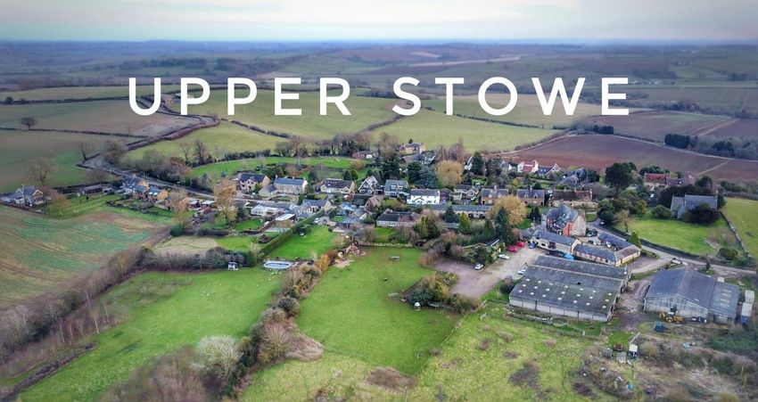
This document is copyright ©2019 Stowe Nine Churches Parish Council

Tithe maps are ©Crown Copyright Images reproduced by courtesy of The National Archives, London, England.
www.NationalArchives.gov.uk & www.TheGenealogist.co.uk

All other maps are ©Crown Copyright and ©Ordnance Survey reproduced by courtesy of Parish On-Line

Photographic Acknowledgements:
Andrew Overton for aerial photographs
Jo Dickson
Julie Francies
Jonathan Hillyard
Linda Hillyard
Tony Hillyard
Helen Kirby
Len Kirby
Barry Prior
Rebecca Teague
Tony Teague

                                                                                                           2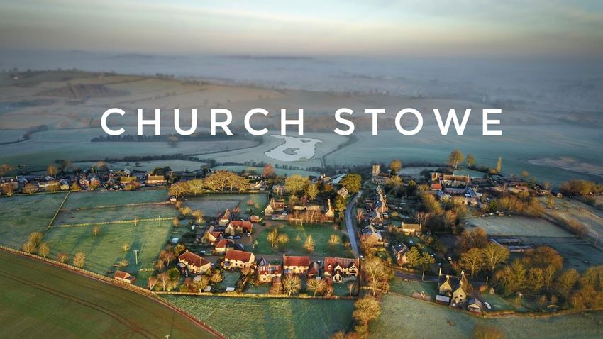
Contents
Contents ............................................................................................................................................... 3
1. Summary, Process & Purpose ....................................................................................................... 6
2. Introduction .................................................................................................................................. 7
3. Parish Context ............................................................................................................................... 8
4. Parish History ................................................................................................................................ 9
5. Landscape ................................................................................................................................... 11
5.1 Dark Sky Policy ...................................................................................................................... 11
5.2 Key Landscape / Views .......................................................................................................... 12
6. Settlement Pattern & Views........................................................................................................ 14
6.1 Upper Stowe Settlement Pattern ........................................................................................... 15
6.2 Upper Stowe Views ............................................................................................................... 16
6.3 Church Stowe Settlement Pattern .......................................................................................... 17
6.4 Church Stowe Views .............................................................................................................. 20
7. Community & Economy .............................................................................................................. 21
8. Local Green Spaces ..................................................................................................................... 22
9. Trees, Environment & Wildlife .................................................................................................... 23
9.1 Tree Preservation Orders ....................................................................................................... 24
10. Buildings & Design ...................................................................................................................... 26
10.1 Overview .............................................................................................................................. 26
10.2 Listed & Important buildings.................................................................................................. 27
10.3 Other important features ...................................................................................................... 28
11. Highways, Utilities & Street Furniture ........................................................................................ 31
11.1 Roads & Streets ..................................................................................................................... 31
11.2 Parking.................................................................................................................................. 32
11.3 Public Footpaths.................................................................................................................... 32
11.4 Lighting ................................................................................................................................. 33
11.5 Street Furniture..................................................................................................................... 33
11.6 Signage ................................................................................................................................. 35
12. Conclusion ................................................................................................................................... 37
Appendices ......................................................................................................................................... 38
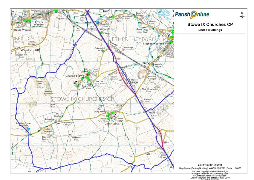
Appendix 1 - Parish boundary including footpaths ............................................................................. 38
Appendix 2 - Wildlife sites within the parish of Stowe Nine Churches ................................................ 39
Appendix 3 - Tree Preservation Orders & Local Green Spaces within Stowe Nine Churches ................. 40
Appendix 4 - Listed & Important Buildings within Stowe Nine Churches ............................................. 41
3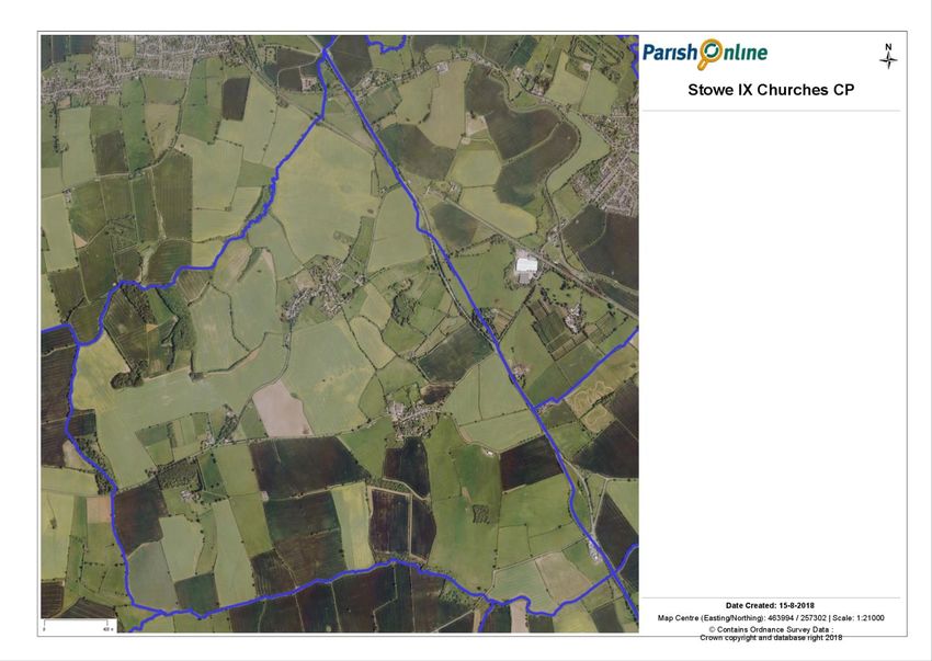
Appendix 5 - Grade I listed buildings ................................................................................................. 42
   Appendix 6 - Grade II listed buildings ................................................................................................ 42
   Appendix 7 - Other important buildings ............................................................................................ 46
   Appendix 8 - Current Planning Policies .............................................................................................. 47
Stowe Nine Churches Village Design Statement ................................................................................ 48

List of Figures

Figure 1: Church Stowe from the west ..................................................................................................... 6
Figure 2: St Michael's Church, Church Stowe ........................................................................................... 7
Figure 3: War Graves Commission headstone .......................................................................................... 9
Figure 4: Memorial to World War 1 & 2 .................................................................................................. 9
Figure 5: The Radar memorial and the field path to Upper Stowe .......................................................... 10
Figure 6: Main Street, Church Stowe towards A5 ................................................................................... 12
Figure 7: Views from field from Waterloo Barn ..................................................................................... 12
Figure 8: View of countryside behind The Old Forge, Upper Stowe ......................................................... 12
Figure 9: From St Michael's Church, Church Stowe ................................................................................. 12
Figure 10: Entering Upper Stowe from A5 ............................................................................................. 12
Figure 11: Views from field near Waterloo Barn .................................................................................... 13
Figure 12: Views from field near Waterloo Barn .................................................................................... 13
Figure 13: Aerial view of Stowe Nine Churches Parish Boundary ............................................................ 14
Figure 14: Francis Row junction with Main Street, Upper Stowe ............................................................ 15
Figure 15: Main Street, Upper Stowe .................................................................................................... 15
Figure 16: 1839 Tithe Map, Upper Stowe .............................................................................................. 15
Figure 17: 2019 Map of Upper Stowe .................................................................................................... 16
Figure 18: Views around Upper Stowe .................................................................................................. 17
Figure 19: Western end of Main Street, Church Stowe ........................................................................... 17
Figure 20: The Green, Church Stowe...................................................................................................... 17
Figure 21: Eastern entrance to Manor conversions ................................................................................ 18
Figure 22: Western entrance to Manor conversions ............................................................................... 18
Figure 23: 1839 Tithe Map, Church Stowe ............................................................................................. 18
Figure 24: 2019 Map of Church Stowe ................................................................................................... 19
Figure 25: Views around Church Stowe ................................................................................................. 20
Figure 26: The Old Dairy Farm entrance ................................................................................................ 21
Figure 27: 1 & 2 Main Street, Upper Stowe............................................................................................ 26
Figure 28: Cavalier Cottage, Upper Stowe ............................................................................................. 26
Figure 29: Main Street, Church Stowe ................................................................................................... 27
Figure 30: Example 1 of stone boundary wall ........................................................................................ 27
Figure 31: Example 2 of stone boundary wall ........................................................................................ 27
Figure 32: Example 3 of stone boundary wall ........................................................................................ 27
Figure 33: Ninety-degree bend by St Michael's Church, Church Stowe .................................................... 31
Figure 34: Ninety-degree bend by Old Schoolrooms, Church Stowe ........................................................ 31
Figure 35: Sharp bend in road leaving Upper Stowe .............................................................................. 31
Figure 36: Sharp bend in road entering Upper Stowe ............................................................................. 31
Figure 37: Millennium bench, Upper Stowe ........................................................................................... 33
Figure 38: Examples of benches, Church Stowe...................................................................................... 33
Figure 39: Traditional red telephone box............................................................................................... 34
Figure 40: Defibrillator in telephone box ............................................................................................... 34
Figure 41: Stone bus shelter, Church Stowe ........................................................................................... 34

                                                                                                                                           4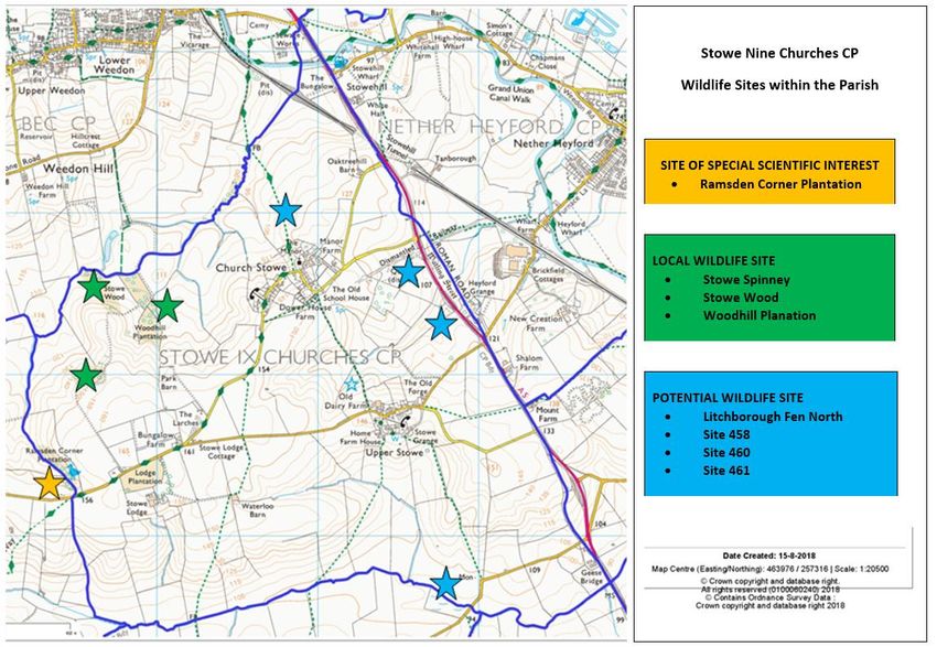
Figure 42: Metal railings around children's swing area, Church Stowe ................................................... 34
Figure 43: Notice board, Church Stowe ................................................................................................. 34
Figure 44: Grit bin, Church Stowe .......................................................................................................... 34
Figure 45: Stowe Nine Churches village sign .......................................................................................... 35
Figure 46: Right of Way, Upper Stowe .................................................................................................. 35
Figure 47: Footpath signage, Church Stowe........................................................................................... 35
Figure 48: Right of Way, Church Stowe ................................................................................................. 35
Figure 49: Road sign on road from A5, Church Stowe............................................................................. 35
Figure 50: Church of St Michael, Church Stowe ...................................................................................... 42
Figure 51:Wyndham House, Church Stowe ............................................................................................ 42
Figure 52: Coach House to Wyndham House, Church Stowe ................................................................... 42
Figure 53: The Beeches, Church Stowe .................................................................................................. 42
Figure 54: Dower House Farmhouse, Church Stowe ............................................................................... 43
Figure 55: Dovecote at The Manor, Church Stowe ................................................................................. 43
Figure 56: The Manor, Church Stowe .................................................................................................... 43
Figure 57: Vineyard Farmhouse, Church Stowe ...................................................................................... 43
Figure 58: Oaktreehill Barn, Church Stowe ............................................................................................ 44
Figure 59: Old Dairy Farmhouse, Upper Stowe ...................................................................................... 44
Figure 60: Church of St James, Upper Stowe .......................................................................................... 44
Figure 61: Leys House, Upper Stowe...................................................................................................... 44
Figure 62: Cavalier Cottage, Upper Stowe ............................................................................................. 45
Figure 63: Home Farmhouse, Upper Stowe............................................................................................ 45
Figure 64: The Closed Church of England School, Church Stowe .............................................................. 46
Figure 65: The Old Dairy Farm Centre, Upper Stowe .............................................................................. 46
Figure 66: The War Memorial, Church Stowe ........................................................................................ 46
Figure 67: The Radar Memorial ............................................................................................................ 46

                                                                                                                                             5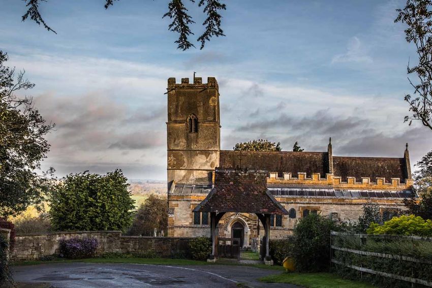
1.      Summary, Process & Purpose
1.1     The Parish of Stowe Nine Churches in Northamptonshire encompasses the two settlements of Church
Stowe and Upper Stowe, together with outlying rural properties. Preparation of the Village Design Statement
(VDS) began in 2017 with the aim of being adopted as Supplementary Planning Document to work in
conjunction with the Daventry District Council (DDC) Settlements & Countryside Local Plan Part 2. It is
intended to be a useful resource that will also raise awareness of design issues within Stowe Nine
Churches, contribute to the overall improvement of local planning decisions, and so help to preserve the
character of the two settlements within the Parish.

1.2      During 2017, Stowe Nine Churches Parish Council agreed that it would be appropriate to develop a
VDS to reflect the views of the local community such that these could be adequately represented during the
consideration of planning applications. This document will be adopted as a Supplementary Planning Document by
Daventry District Council. It will be a material consideration when considering any planning application in or near
the parish and provides guidelines for future changes.

1.3      Following advice taken from Northamptonshire Action with Communities in Rural England (NACRE), a
VDS launch event was held on 25th November 2017 and this was attended by almost 50 parishioners. A survey
completed by those attending provided insight into the views and priorities of the local community, whilst almost
30 of those attending volunteered to take part in the subsequent development of the VDS.

1.4     During 2018, a Working Party comprising five sub-groups developed each of the various themes to be
covered by the VDS and these have subsequently been integrated into this version of the document which has
been reviewed by both the Working Party itself, and the Parish Council.

1.5      Following approval by the Parish Council, a period of local consultation was undertaken between June
and September 2019, during which copies of the document were made available on notice boards and within the
local parish churches; this was followed by an Open House event to which all parishioners were invited and during
which questions were answered and clarification provided by members of The Parish Council. No issues or
objections were raised during this period.

1.6       Finally, the VDS was submitted to DDC as the local Planning Authority whose comments and feedback
were incorporated prior to a further period of public consulation. This updated version is now submitted for final
sign off and adoption as a Supplementary Planning Document.

                                       Figure 1: Church Stowe from the west

                                                                                                                     6
2.      Introduction
 2.1      The Village Design Statement (VDS) describes the parish
 of Stowe Nine Churches as it is today and highlights the qualities          Who should
 valued by its residents. This document has been produced by a
 large group of villagers following an open launch event to which all       use this guide?
 households were invited. In this way local knowledge, views and
 ideas will contribute to improving the quality of our environment.        •      Property owners planning
                                                                                  extensions and changes
 2.2      The open meeting was held in November 2017 to launch             •      Developers and Builders
 VDS development process, and to seek comments. During the
                                                                           •      Stowe Nine Churches Parish
 revision process drafts of the document have been published on
                                                                                  Council
 the Stowe Nine Churches Parish Council Website and comments
 sought there and through the village Facebook page, so that they          •      Daventry District Council
 in turn have influenced this final document.                              •      Highways authorities
                                                                           •      Utility companies

2.3    This VDS is aimed at ensuring that our local distinctiveness and character is taken into consideration
when location planning decisons are being taken.

2.4     In this document, the term "Stowe Nine Churches" refers to both of the two settlements of Church Stowe
and Upper Stowe and the rural landscape surrounding them within the Parish boundaries delineated on the map
in Appendix 1.

2.5      This document is expected to be adopted as a Supplementary Planning Document by Daventry District
Council. It will be a material consideration when considering any planning application in or near the parish and
provides guidelines for future changes.

                                    Figure 2: St Michael's Church, Church Stowe

                                                                                                                   7
3. Parish Context
3.1 The parish of Stowe Nine Churches lies atop a low range of undulating hills, known as the
Northamptonshire Heights. Covering nearly 781 hectares, the parish lies south west of Watling Street (A5) which
forms its north eastern boundary, and approximately 5 miles north of the town of Towcester.
3.2 The west and central part of the parish is occupied by a wide flat-topped plateau that divides to become
two ridges on which stand, approximately 1km apart, the two settlements of the parish, Church Stowe and Upper
Stowe. The parish of Stowe Nine Churches consists of 115 houses, 2 churches, and the Old School Rooms which is
used as a village hall, as well as several farms and the Old Dairy Farm Craft Centre.
3.3 In Daventry District Council’s ‘Settlements and Countryside Local Plan Part 2’ Church Stowe has been
designated as an “other village” which has a limited range of services, e.g. the Old School Rooms. Therefore, it is
considered that development should be limited to being small scale and within the confines. Upper Stowe is
classed as a “small settlement/hamlet” and equivalent to ‘open countryside’ and any development is judged
against open countryside policies.
3.4 Both settlements within Stowe Nine Churches are characterised by a typical linear format with
development fronting onto and following the main road. In Church Stowe this linearity is punctuated with areas
of open agricultural land which softens the built form providing views into and a sense of the proximity of the
surrounding countryside. This is less the case in Upper Stowe which, although smaller in terms of dwellings, has a
harder street scene which extends into a parallel road. Between the villages, the settlement pattern includes
scattered farmsteads and dwellings located both adjacent to roadsides, and set back from the road and accessed
via minor tracks.
3.5 The parish has a dark sky policy and has no streetlights; this means an unusually large amount of stars can
be seen on a clear dark night. It also gives the settlements a quiet, peaceful, non-intrusive feel, without
compromising a sense of safety and security due to a low level of background light emanating from the glow over
Northampton, Daventry and Banbury. This is a valuable asset that is important for wildlife and benefits the health
and wellbeing of residents.
3.6 The parish contains 3 major arterial transport features:
Watling Street - A5 trunk road (north, south)
Grand Union Canal
West Coast Mainline Railway
8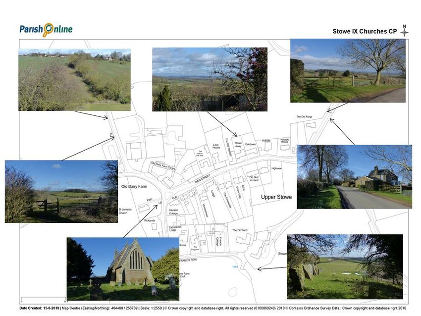
4.      Parish History
4.1    Parish register records begin in 1558; however, recent studies suggest that Stowe Nine Churches may be
more important in an historical context.

4.2       Adjacent to the old Roman road of Watling Street (A5) and lying halfway between the important Roman
town of Towcester and the large Whitehall Roman Villa, the parish has strong historical connections to Roman
Britain. By virtue of its topography and hydrology, the parish has been established as a strong candidate for the
battle site of Boudicca’s last stand. Analysis of the area around Church Stowe has identified apparent field
fortifications which may be attributable to Roman military fortifications (craft: pegg 2010)

4.3     Towards the west end of the Parish, adjacent to The Larches, Church Stowe, lies a Scheduled Ancient
Monument (SAM NN120), comprising of a series of Bronze Age earthwork banks and ditches, and although these
are considerably overgrown, they have been subjected to archaeological investigation and recording.

4.4      Reference to the settlement of Church Stowe can also be found in the Doomsday Book where it records
that in 1086 the population was quite large at 27 households and the Lord of the Manor, Gilbert of Ghent,
received rent from the villagers of £5.

4.5      Records show that in 1716 the charity ‘Corporation of the Sons of Clergy’ purchased 1,493 acres as well
as 120 acres of woodland for £15,500. The charity, which was founded in 1655 by a group of merchants in the
City of London, together with a group of sons of clergymen, was established to provide for destitute clergy and
their families during the time of Oliver Cromwell, and still exists today. The Corporation were the Lords of the
Manor for the next 200 years, relinquishing their estates just before the First World War.

4.6       By 1853 a limestone quarry had been established to the south of the road from Church Stowe to what is
now the A5. It was linked by a horse worked tramway which led under the main railway to the canal between
Nether Heyford and Weedon. The limestone quarry ceased operation in 1900, however, parts of the tramway
embankment can still be seen between the A5 and the railway. There were also a number of gravel pits around
the village, evidence of which can still be seen.

4.7      There are three memorials related to the two World Wars situated within the Parish; within St James’
churchyard in Upper Stowe lies a single Commonwealth War Graves Commission headstone to the memory of
Private T.J. Colley who died on 2nd May 1918 during World War 1.

         Figure 3: War Graves Commission headstone              Figure 4: Memorial to World War 1 & 2

                                                                                                                    9
4.8      Close by to the main memorial at Church Stowe
 is a plaque inside the Old School Rooms which
 commemorates the amount of £260 raised by the
 Parish in support of a War Memorial appeal by
 Northampton General Hospital following the World War
 2.

 4.9      The parish also played a significant role as the
 birthplace of radar and a memorial to its discovery
 was unveiled in September 2001 in a field at the
 extreme south-east corner of the Parish; this is connected to Upper Stowe by a path (public right of way) across
 the fields. For location, see map at Appendix 1.

                         Figure 5: The Radar memorial and the field path to Upper Stowe

4.10     The memorial marks the place where the experiment that first proved the possibility of Radar was carried
out in 1935, when, asked by the Air Ministry for a demonstration of his theories, Arnold Wilkins chose a field near
Upper Stowe to set up receiving equipment from the National Physical Laboratory in London, which he installed in
an old ambulance parked in the field across the road from the memorial.

4.11    On the 26 February 1935 a bomber airplane flew along a path between the receiving station near Upper
Stowe and the transmitting towers of a BBC shortwave station in nearby Daventry. This convincing test, known as
the Daventry Experiment, was witnessed by a representative from the Air Ministry, and led to the immediate
authorisation to build a full demonstration system. Without this experiment, it is widely thought that the
outcome of World War 2 would have been very different.

                                                                                                                10
5. Landscape
5.0.1 The Parish is located in Landscape Charcter Type 3 Undulating Hills and Valley (LCT 130 and specifically
Landscape Character Area 13a: Woodford Halse and Weedon Bec (LCT13). The ‘Daventry Landscape Character
Assessment’ sets out the characteristics for this landscape character area and a strategy for conserving and
enhancing the landscape.
5.0.2 Geologically, the soil character is a mixture of lias clay, ironstone and Northampton sand which gives rise to
a number of springs within the Parish. This sandstone is iron rich, making it ‘a warm brown with a hint of orange’
and the colour of the stone varies considerably both within and between blocks. The soil on top is free draining
which provides excellent grazing for sheep and cattle as well as good arable soil.
5..0.3 There are long views across the Parish afforded by the open countryside. The field boundaries are
marked by rich and varied hedgerows. The Parish contains approximately 7km of footpaths within its boundaries;
there are woods, coppices and ponds, both natural and man-made across the parish. See map at Appendix 1.
5.0.4 The local topography is rapidly undulating and covered by a patch work of differing arable and livestock
fields, broken up by a network of hedgerows and sporadic woodland/ copses.
5.0.5 Within the Parish is Ramsden Corner Plantation, a 3.2 hectare biological Site of Special Scientific Interest,
see map at Appendix 2. It is managed by the Wildlife Trust for Bedfordshire, Cambridgeshire and
Northamptonshire. A stream runs through this valley site, which is acidic grassland, woodland and scrub on clay
and sand. Plants such as wood millet, wood-sorrel and wood vetch are indicators of ancient woodland. Opposite-
leaved golden-saxifrage is found in wet flushes.
5.0.6 There are also three areas within the Parish which are designated as Local Wildlife Sites (Woodhill
Plantation, Stowe Wood and Stowe Spinney) and four other sites which Northamptonshire Biodiversity Record
Centre have designated as ‘potential wildlife sites’ (Site 458, Site 460, Site 461 and the site named Litchborough
Fen North, near the radar memorial). In the north of the parish lies the Grand Union Canal which is part of the
counties ‘Nene Valley Nature Improvement.’ See map at Appendix 2.
5.0.7 Hedgerows are a significant visual amenity in the parish and perform important roles as stock proof
boundaries as well as wildlife corridors. Many of the hedges are a result of the Enclosure Act in the 18th Century.
5.0.8 The Parish is bounded by open countryside which has been protected through Policy RA6 Open
Countryside of the Settlements and Countryside Local Plan Part 2. This has successfully preserved its character
and is valued by villagers. A comparison between the extent of the village and the Tithe Maps of 1839 shows that
very little has changed in 180 years - see Settlement Patterns, below.
5.1 Dark Sky Policy
5.1.1 The village policy is to retain as dark a sky as possible; this view is supported by a broad consensus of
parishioners. There is ambient spill light coming from Northampton, Daventry and Banbury, and this appears to
give enough light for villagers to move around and feel secure. There is no demand for any street lighting in the
village, therefore there is no minimum standard as there would be with a normal street lighting installation.
5.1.2 The recommendation for households and businesses is that they should ensure they have adequate light
when they need it, so as to effectively and safely carry out any tasks on their premises, however light levels should
not be excessive and spill light should not pass over their boundaries or go upwards.
5.1.3 New developments will be expected to comply with this policy.
115.2 Key Landscape / Views
5.2.1 Favoured views in and out of the Parish are illustrated below.
Figure 7: Views from field from Waterloo Barn
Wide vistas across the valley towards the southern
Parish boundary
Figure 6: Main Street, Church Stowe towards A5
At the height of summer the over-arching foliage creates
a cool green tunnel on the approach to the village
Figure 8: View of countryside behind The Old Forge, Upper Stowe
Dramatic view across the fields that separate the two halves of the Parish
Figure 9: From St Michael's Church, Church Stowe
Expansive views towards Weedon and the northern boundary of Figure 10: Entering Upper Stowe from A5
the Parish A timeless view that shows the warmth of the
local ironstone
12Landscape Guidelines
• Unencumbered open countryside surrounding the two village settlements is
important and should be protected, and not compromised by inappropriate or
unsympathetic new development (see Figs.6-10, 18 & 25).
• Any development within the Parish should value existing trees and green space and
new planting / landscaping should be appropriate to the character and context of
the site. Developers, landowners and farmers are encouraged to preserve existing
hedgerows and to restore them where necessary. Hedgerows and trees should be
conserved and opportunities sought to increase these, making use of appropriate
tree planting. Tree and hedgerow species planted should reflect native species
found within the wider area.
• Important views within the Parish and visual links into the surrounding countryside
should be protected (see map and photographs above); any changes or
development impacting the key visual approaches into and out of each of the two
settlements should be sympathetic and appropriate to the surroundings.
• Where appropriate applications for development should be accompanied by tree
surveys, landscape and visual character assessments, and detailed landscape
proposals demonstrating adherence to this principle. The Landscape Guidelines in
the Daventry Landscape Character Appraisal for LCT13 should be referred to. Regard
should be made to the Local Requirements for Planning Applications as provided by
DDC see: https://www.daventrydc.gov.uk/living/planning-and-building-
control/planning-application-forms/.
• Any application for development should be sympathetic towards the preservation
of landscape views and features favoured and approved of by Parishioners. For
example the ‘green tunnel’ on approach to Church Stowe.
• Local Wildlife Sites must be considered before development is permitted that
would result in their loss or deterioration. Full wildlife surveys should be carried
out to establish habitats of value and to include new habitat creation.
• Existing households and new developments should not impact the dark sky policy
of the Parish (see above). External lights should be around 3000k in colour
temperature, mounted as high as possible and generally pointed down as much
as possible, with low wattage lamps that are adequate for the task and do not
emit significant light upwards, or beyond the boundaries of the property.
Presence detectors and timers should be used so that the lights are not on
Figure 11: Views from field near Waterloo Barn
unnecessarily.
Figure 12: Views from field near Waterloo Barn
• Where new agricultural buildings are necessary in open countryside they should
be located and designed to minimise their visual impact.
136. Settlement Pattern & Views
6.0.1 The parish of Stowe Nine Churches consists largely of mixed agricultural land with some woodland.
Habitation consists mainly of two settlements - Church Stowe and Upper Stowe, together with a scattering of
farmhouses.
6.0.2 Between the settlements there are scattered farmsteads and dwellings located both adjacent to
roadsides and set back from the road and accessed via minor tracks.
6.0.3 The distinctive character of both settlements is largely determined by their compactness and sharp
transition (lack of sprawl) from built environment to countryside with extensive, rolling views. This gives the
feeling of two settlements embedded in, and being part of the countryside, rather than a larger development
which has replaced the countryside. Neither settlement has street lighting, which again enhances the rural quality
and enables the night sky to be enjoyed in all its beauty.
Aerial view of Stowe
Nine Churches Parish
Boundary
Figure 13: Aerial view of Stowe Nine Churches Parish Boundary
6.0.4 The two settlements are separated by a shallow valley through which runs an un-paved but well used
footpath connecting the two. Above is an aerial photograph which shows the Parish boundary, the rural nature,
and the position of the two settlements within the Parish.
6.0.5 The two, primarily linear, settlements are built along two adjoining ridges, with the ground falling away
on each side, each predominantly consisting of houses flanking both sides of a main street. This positioning
provides open and beautiful views from both settlements over the rest of this rural Parish.
146.1 Upper Stowe Settlement Pattern
6.1.1 Upper Stowe consists of the single 'Main Street' together with a single spur cul-de-sac, 'Francis Row',
which diverges from Main Street at a small green near the western entrance to the hamlet. The nature of the
junction gives the impression of a small single track road leading off into the countryside (see below), and
preserves the impression of the hamlet as a single, small linear settlement along both sides of Main Street.
Figure 14: Francis Row junction with Main Street,
Figure 15: Main Street, Upper Stowe
Upper Stowe
6.1.2 This street layout has been preserved since at least 1839 as a comparison of the Tithe Map of that date,
with the current map shows:
Figure 16: 1839 Tithe Map, Upper Stowe
15Figure 17: 2019 Map of Upper Stowe
6.1.3 The majority of buildings are in local ironstone/limestone, with the older buildings being generally set
nearer the road, and any newer infill or replacement building being set back from the road, generally behind
ironstone/limestone walls. The result gives an overall feeling of a traditional ironstone settlement as illustrated in
the above photograph showing Main Street, Upper Stowe.
6.1.4 Apart from two pairs of semi-detached ironstone cottages at the western end of the Main Street, the
remaining dwellings have off road parking which means there is generally little on road parking, again
contributing to the rural feel of the community.
6.1.5 Although the hamlet is small, comprising just 34 dwellings, it contains five listed buildings; the locations
and full details of these are provided in Appendices 4 and 6.
6.2 Upper Stowe Views
6.2.1 Upper Stowe provides unimpeded views over the surrounding countryside, with gaps in the building line
maintaining contact with the countryside and carrying the feeling of being part of the countryside throughout the
hamlet. The map below illustrates the views from various points within the village.
16Figure 18: Views around Upper Stowe
6.3 Church Stowe Settlement Pattern
6.3.1 Church Stowe has developed along a ridge line with a single 'Main Street' flanked by houses on either
side (see photograph below left). There are two newer developments: 'The Green', and 'The Manor'.
6.3.2 The Green consists of a small collection of well spaced new build stone houses set around a large 'village
green' alongside Main Street. The green dominates the houses and preserves the small rural village feel of the
rest of the village (see below right).
6.3.3 The Green is a valued open space which has been designated under the Parish Annexe process of the
Settlements & Countryside Local Plan Part 2 (see ‘Local Green Spaces’).
Figure 19: Western end of Main Street, Church Stowe Figure 20: The Green, Church Stowe
176.3.4 'The Manor' consists of the manor house itself together with a collection of barn conversions; it lies along
a private gravel drive which loops off Main Street, through the Manor conversions, before rejoining the Main
Street at the eastern edge of the village. This gravel drive is un-metalled and single track and preserves a very
rural and open feel at its two junctions with Main Street, giving little or no clue to the conversions beyond (see
below).
Figure 21: Eastern entrance to Manor conversions Figure 22: Western entrance to Manor conversions
6.3.5 With the sole exception of ‘The Green’, the current street layout again pre-dates 1839 as a comparison of
the Tithe Map of that date, with the current core of the built form of the village shows:
Figure 23: 1839 Tithe Map, Church Stowe
18Figure 24: 2019 Map of Church Stowe
6.3.6 Although small, Church Stowe is home to no less than 8 listed buildings with a further listed barn on the
north-eastern approach road to the village; the locations and full details of these are provided in Appendices 4 &
6.
196.4 Church Stowe Views
6.4.1 Views in and around Church Stowe are those of a quintessential small English village, with the
countryside seeming to reach into the village as one enters, and with sweeping views over the surrounding hills
and fields revealing themselves through gaps in the building line, thus maintaining intimate contact with the
countryside throughout. Views at various points within the village are illustrated below.
Figure 25: Views around Church Stowe
Settlement Guidelines
Any development should be in keeping with the linear character of the settlements.
DDC’s ‘Settlements and Countryside Local Plan Part 2’ identifies Church Stowe as an
‘other village’. Under the terms of this designation, any development will be restricted
to small scale within the confines (as per para.5.2.23), preferably with new-build
properties being set back from the road with stone walls nearer the verge to preserve
the essence of the Parish vernacular.
Upper Stowe is classed as a ‘small settlement/hamlet’ and such is not considered as a
sustainable location for additional development. Proposals for development will be
judged against ‘open countryside’ policies within DDC’s ‘Settlements and Countryside
Local Plan Part 2’.
207. Community & Economy
7.1 Amenities for the Parish are situated in Church Stowe, and comprise the Old School Rooms and
associated small playing area with swings which is cared for by volunteers; these are owned by the Church and
managed by Church trustees. The Old School Rooms provide the setting for Church activites and a range of other
community events including Mums & Tots, Table Tennis, coffee mornings, and as a meeting room for groups such
as the WI.
7.2 There is no school within either of the villages and education is provided by primary schools situated in
Weedon, Flore, Nether Heyford, and Bugbrooke, and secondary schools in Bugbrooke and Daventry.
7.3 There is no public transport within either settlement, the nearest bus routes in Nether Heyford and
Weedon Bec provide transport to both Daventry and Northampton, whilst the nearest railway stations are found
at Northampton and Long Buckby.
7.4 Businesses comprise units at the Old Dairy Farm in Upper Stowe, together with a number of
homeworkers spread across the two settlements.
7.5 As well as still being a working farm, The
Old Dairy Farm unobtrusively houses, in converted
farm buildings, a café/tea room together with a
small number of craft shops. The businesses here
operate from existing, mainly stone or brick built
farm buildings, thus maintaining the village feel, as
shown. To the rear, other redundant barns have
been adapted to accommodate a variey of larger
commercial enterprises such as a blacksmith’s
workshop, a wood-turner, and a catering business.
Figure 26: The Old Dairy Farm entrance
7.6 Farming remains important, and probably still represents the major economic activity across the
Parish. Other than the two settlements and a few small areas of woodland, the vast majority of the Parish is
actively farmed, with arable and non-intensive livestock (mainly sheep grazing) accounting for most of the land
usage. The farming activity is managed by a number of farms spread over the Parish and beyond.
7.7 Opportunities for further farming diversification and the commercial re-use of redundant farm buildings
will be encouraged where the intended use is sympathetic to the rural environment and ambience, as well as
respecting the Development Guidelines.
Community & Economy Guidelines
• Businesses established within Stowe Nine Churches should be ‘good
neighbours’ – s y m p a t h e t i c t o t h e r u r a l e n v i r o n m e n t a n d not
adversely affecting the community with unreasonable working hours, pollution of
any kind, or generating unreasonable extra traffic volumes.
• Proposed business developments should not be intrusive and will need to
demonstrate how they will comply with DDC & Village Design policies; see DDC
Settlements & Countryside Local Plan Pt.2, policies SP1, ENV1, ENV2, ENV5 &
ENV10
• Business security arrangements must be compliant with the Dark Skies Policy
described elsewhere in this document
218. Local Green Spaces
8.1 A number of open spaces important to the Parish have recently been designated as Local Green Space
through the ‘Parish Annexe’ under DDC’s Settlements and Countryside Local Plan Part 2, in line with para 100 of
the National Planning Policy Framework (2018) which states that such open spaces should be:
In reasonably close proximity to the community
Demonstrably special to a local community, holding particular local significance
Local in character and not an extensive tract of land
The areas designated within the Parish are:
8.2 THE GREEN – CHURCH STOWE this large, privately owned open 'village green' was created alongside
Main Street as an adjunct to the small, modern collection of new build stone houses which are set around it. It is
owned and managed by the owners of those properties and helps to preserve the small rural village feel of the
rest of the settlement.
8.3 OLD SCHOOLROOMS PLAYGROUND – CHURCH STOWE provides the only safe place for children of all
ages to play upon within the Parish. It is well used and highly valued for both Parish and private functions and is
the venue for all outdoor village events. The playground is a grassed area which belongs to the Church. On the
side not bordered by the road, it is adjoined by open fields and looks across the valley to Upper Stowe.
8.4 WAR MEMORIAL – CHURCH STOWE - This is a grassed area in the heart of Church Stowe which
surrounds the Parish War Memorial and adjoins the Old School playground; it commemorates the fallen from the
two settlements. It is the location for the Parish’s annual Remembrance Day service and as a consequnce it is a
space that is highly prized by parishioners. It is situated between the Old Schoolrooms playground and the start of
the footpath locally known as the Gravel Path. The grass is mown by parishioners on a voluntary basis.
8.5 ST. JAMES’ CHURCHYARD – UPPER STOWE - Part of the churchyard which surrounds the Church has
been turned into a wildflower meadow by volunteers to encourage both wildflowers and wildlife. It has brought
together a large number of people who meet regularly to look after the projects which have been introduced
over the past two years. A haymaking day takes place once a year to remove all the grass from the meadow and
is well supported by everyone. It is adjacent to farmland and affords views to the west towards Stowe Lodge.
8.6 These local green spaces make a positive contribution to local character and distinctiveness, and the
sense of countryside proximity which is so valued by the Parish. Their locations are shown in the map at Appendix
3.
8.7 The designation of these Local Green Spaces under the Parish Annexe initiative means that no additional
Open Space Guidelines are proposed.
229. Trees, Environment & Wildlife
9.0.1 Trees and hedges are an important part of the Parish landscape giving enjoyment in their own right, but
also softening the hard edges of the built environment. Both settlements can be seen clearly from the A5 when
approaching from both the North and South. Oak and ash trees predominate in field boundary hedges.
9.0.2 Outside the villages there are a variety of native species of trees and shrubs planted along the verges
which maintain a diversity of wildlife.
9.0.3 Such areas cannot work in isolation as wildlife cannot thrive in a small island of protected land. The trees
and hedges that are a feature of the villages and the approach roads are therefore of the utmost importance to all
forms of wildlife.
9.0.4 There are several woods on agricultural land which faces towards Weedon below Church Stowe.
Ramsden Corner is a 3.2 hectare biological Site of Special Scientific Interest right on the boundary of the parish on
the Preston Capes Road. It is managed by the Wildlife Trust. A stream runs through this valley site which is made
up of grassland, woodland and scrub. A large variety of birds can be seen on the site. Other woods in this area are
Stowe Wood, Woodhill Plantation (also known locally as the Tin Shack), Park Barn, Birch Poles and Warners
Wood. There has been an increase in tree planting over the past few years and this should be encouraged.
9.0.5 The Lodge Plantation is situated on the south side of the Preston Capes Road. This was originally the site
of an ironstone quarry which was closed in the late 1800’s and is planted mainly with larch with some beech and
ash trees. You can still see gullies where the tram which took the ironstone out of the quarry down to Nether
Heyford used to run. A large avenue of lime trees runs next to the Plantation.
9.0.6 The Earthworks next to The Larches is also now planted with trees. A large lime tree stands in the
churchyard at St. Michael’s church. On the opposite side of the road a large cedar tree (TPO) stands in the garden
of Wyndham House.
9.0.7 As one enters Church Stowe from the A5 a ‘tunnel’ effect is produced by trees on either side of the road;
this is highly valued by parishioners and should be preserved. There are a varied number of trees within the
village both in species and age. The Parish has planted several oak trees in Oaktree Hill. The old sandstone
quarry situated to the right of Sandy Lane as you leave the village is now overgrown with a large amount of self-
set trees. Within the village there are visually significant trees within private gardens.
9.0.8 Upon entering Upper Stowe from the A5 (Leys Hill), there are several mature ash trees in the roadside
hedge, and a mixture of chestnut, ash, maple and cherry have also been planted by parishioners. The drive
leading to Stowe Fields is planted with a mixture of native trees on the left hand side and silver birches on the
right hand side.
9.0.9 Three small areas of native woodland have been planted during the last 30 years in the valley below
Francis Row which faces Cold Higham. These are a rich addition and have the potential to become an increasingly
important feature of the village landscape. A plantation of spruce trees planted at the bottom of Francis Row
next to the footpath were originally planted as Christmas trees but are now mature trees.
9.0.10 The southern boundary of the parish which runs along the brook from Geesebridge on the Litchborough
Road has a mixture of mature willow, oak and ash growing along its length.
9.0.11 A Chestnut tree is planted in the triangle by St. James’ Church which has a circular seat around its base
that was made to mark the Millennium. Native lime trees have been planted in the hedge along Northfield Lane
during the past few years and there is a large ash tree as you enter the village. A large fir tree is situated by the
junction of Northfield Lane and Main Street.
239.0.12 Daventry District Council has published a Biodiversity Supplementary Planning Document which provides
useful guidance on how biodiversity should be taken into account in the planning process. Natural England has
published guidance on delviering green infrastructure at a local scale.
9.1 Tree Preservation Orders
9.1 Trees covered by Tree Preservation Orders are as follows:
DA 12: 3 limes in Field off Main Street, Church Stowe (Mr Lucas's field), PLUS 2 sycamore, 1 beech, 1
horse chestnut, 1 ash, 2 lime, 1 Corsican pine along entrance road into Church Stowe (“the green
arch”)
DA 244 cypressus in the grounds of ‘The Knoll’, Upper Stowe (currently being replaced with new
planting)
DA377 weeping ash in the grounds of 'The Barns', Church Stowe
DA 430 beech tree within the grounds of ‘Beech Lodge’, Church Stowe PLUS five trees in or around
the grounds of ‘Wyndham House’, Church Stowe including cedar tree, two yews and a further 2 yews
9.2 The Parish is situated in a landscape with many attractive views. Trees and hedges are important
elements in the landscape: they help encourage wildlife and are visually satisfying in their own right and should be
maintained and managed appropriately.
9.3 Woodlands, Tree Preservation Orders and SSSI are shown in maps at Appendices 2 and 3.
24Environment & Tree Guidelines
• Wildlife habitats including hedgerows, woodland, trees, shrubs, streams, open
areas and verges in and around the Parish should be maintained and improved.
Within the two settlements these include gardens, churchyards and open spaces.
• Any development on the approach roads to the Parish should avoid damaging the
visual integrity of the avenues of mature hedgerow trees. Replacement of
damaged or diseased trees should be encouraged with appropriate species. The
‘tunnel’ on the approach to Church Stowe is highly valued by parishioners and
should be protected.
• Trees of amenity value should be retained wherever possible. New development
should be carefully designed to ensure tree roots are protected during groundwork
and anyone working in proximity to valued trees should protect them from
damage.
• Where retention is not possible, replacement trees of similar species should be
planted.
• Plant native species to retain landscape character and benefit wildlife within the
Parish; local native broadleaf trees include ash, lime, sycamore, chestnut and oak.
• Hedgerows and trees should be conserved, maintained and re-planted as
necessary. Native species are encouraged rather than fast growing evergreens.
Local species include blackthorn, hawthorn, crab apple, field maple, hazel and ash.
• Developers, landowners and householders shall protect existing wildlife
environments and create new habitats, for example in the form of copses,
hedgerows, ditches, ponds. (Advice is available from Northamptonshire Wildlife
Trust).
• The sensitivity of the local water catchment to pollution and the wildlife corridors
provided by the brooks, ditches, ponds and roadside hedges should be considered
when assessing the impact of new developments in and around Church Stowe and
Upper Stowe.
• Landscaping measures that protect existing wildlife environments and help create
new and connected habitats in the form of copses, hedgerows, ditches and ponds,
and open spaces of rough grassland should be encouraged.
2510. Buildings & Design
10.0.1 Any future development should respect the linear format of the existing built form with development
fronting onto the road.
10.1 Overview
10.1.1 Stowe Nine Churches, in common with many Parishes in the County, has developed visually in an organic
way, particularly through the latter part of the last century. In hindsight, decisions made have resulted in some
inappropriate materials and design.
10.1.2 Fortunately, the juxtaposition of buildings and some of the more imaginative development has preserved
the feel of a small, attractive, rural Parish, particularly within the core of each settlement centred on the churches.
The original questionnaire on the Village Design Statement confirms that residents appreciate the way in which
the Parish has been preserved and enhanced, and wish to continue in this vein in the future.
10.1.3 The community supports the policy contained within DDC’s Community & Settlements Plan which
prevents residential development in the open countryside other than the replacement of an existing dwelling, the
conversion or reuse of existing buildings essential for the purpose of agriculture or forestry, or as determined
under “Paragraph 79”.
10.1.4 The Parish contains a number of listed buildings and although each settlement is different in building
style, there are consistencies across both settlements by way of building materials, repeated use of local stone or
sympathetic coloured materials as well as fencing and hedges. The colour palette across the Parish is
predominantly of natural hues with high use of Northamptonshire stone.
Figure 27: 1 & 2 Main Street, Upper Stowe Figure 28: Cavalier Cottage, Upper Stowe
2610.1.5 Neither settlement has a mains gas supply or
mains sewage. The plethora of overhead cables for
telephone and electricity services has a negative visual
impact on the village both in themselves and the many
poles required to support them.
10.1.6 Many properties, particularly in Upper Stowe are
bounded by traditional Northamptonshire ironstone
walling. These are either free standing stone walls or stone
walled buildings on boundary. This is an important
feature of the settlement, however the use of wooden
fences and hedges of native species are also prominent.
Figure 29: Main Street, Church Stowe
Figure 30: Example 1 of stone boundary wall Figure 31: Example 2 of stone boundary wall
10.1.7 The way entrance gates interact with stone
boundary walls is visually important. Traditionally the
openings are small and allow pedestrian access only
through gates of timber construction. This traditional
style has an attractive simplicity and should be
encouraged. Larger properties with car access directly
from the street often have wooden “5 bar” gates. The
use of high and visually impermeable gates is
discouraged as not being in keeping with the rural
vernacular.
Figure 32: Example 3 of stone boundary wall
10.2 Listed & Important buildings
10.2.1 There are 14 Grade I and II Listed Buildings within the Parish; each of these are detailed together with a
picture and information concerning their listing in Appendix 6.
10.2.2 The buildings referred to below are those which do not have Listed Building status but are nevertheless
considered important by the village for the amenity value they offer. Pictures of these Important Buildings are
also included within Appendix 4:
27You can also read