Draft Mitigated Negative Declaration - Frampton Lot Line Adjustment & Recorded Map Modification - CEQAnet
←
→
Page content transcription
If your browser does not render page correctly, please read the page content below
Draft Mitigated Negative
                          Declaration
               Frampton Lot Line Adjustment &
                 Recorded Map Modification
       19LLA-00000-00003 & 19RMM-00000-00001

     Owner/Applicant               Agent                           Engineer

     Kevin Frampton                Mark Lloyd
     12250 Linda Flora             3 West Carrillo Street, Suite
     Ojai, CA 93023                205

                                   Santa Barbara, CA 93101

For More Information Contact Travis Lee, Development Review South, Planner (805) 568-2046
Frampton LLA/RMM March 17, 2020
Draft Mitigated Negative Declaration Page 1
1.0 REQUEST/PROJECT DESCRIPTION
The proposed project is a request for a Lot Line Adjustment (LLA) & Recorded Map Modification (RMM) to
adjust the property lines and modify the building and development envelopes between two lots for future
residential development. No structural development is currently proposed. The size of the lots would not
change from 2.0 and 10.67 acres but the lot lines and building/development envelopes would change. The
building envelopes identify the location of future structures, construction storage and staging, while allowing
other uses such as grading, utilities, paving, etc. to occur outside the building envelopes. The development
envelopes identify the location of site preparation, ground disturbances and construction activities including
those for structures, access, easements, subsurface grading, sewage disposal, and drainage components. No
ground disturbance, including grading and development is allowed outside the development envelopes. Lot
A, which is 2.0 acres and currently has building/development envelopes of 0.29 and 0.04 acres, respectively,
would have new envelopes of 0.45 and 0.28 acres. Lot B, which is 10.67 acres and currently has
building/development envelopes of 0.37 and 0.12 acres, respectively, would have new envelopes of 0.60 and
0.40 acres. The existing and proposed envelopes are in the same general location on the parcels and the
envelopes have been designed to avoid slopes in excess of 30% while the majority of the slopes within the
envelopes are less than 20%. Future development of the lots would be served by the Montecito Water
District, private onsite wastewater treatment systems, and the Carpinteria-Summerland Fire Protection
District. Access to the site would be provided via Toro Canyon Road via two existing unpaved driveways.
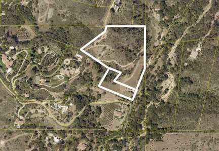
The properties involved include a 2-acre lot and a 10.67-acre lot both zoned 10-E-1 and shown as Assessor's
Lot Numbers 155-230-017 and -018 located at 785 and 805 Toro Canyon Road, in the Toro Canyon Area,
First Supervisorial District.
2.0 PROJECT LOCATION
The proposed project is located at 785 and 805 Toro Canyon Road (APNs 155-230-017 and -018), First
Supervisorial District.
2.1 Site Information
Comprehensive Plan Urban area, Residential with a 10-acre minimum lot size. (APN 155-230-
Designation 017, -018)
Zoning District, Ordinance Land Use & Development Code, 10-E-1 (10-acre minimum lot size)
Site Size Lot A (APN 155-230-017): 2 acres gross, 1.94 net
Lot B (APN 155-230-018): 10.67 acres gross, 10.34 net
Present Use & Development Vacant
Surrounding Uses/Zoning North: Residential, 10-E-1
South: Residential, 10-E-1
East: Vacant, RR-20
West: Residential, 10-E-1
Access Toro Canyon Road via two existing unpaved driveways
Public Services Water Supply Montecito Water District
Sewage: Private onsite wastewater treatment systems
Fire: Carpinteria-Summerland Fire Protection District
3.0 ENVIRONMENTAL SETTING
3.1 PHYSICAL SETTING
The two lots are located on Toro Canyon Road approximately half a mile northeast of its intersection with
East Valley Road in the foothills of the south slope of the Santa Ynez Mountains and in the upper watershed
of Toro Canyon Creek at an elevation of approximately 845 feet above sea level.
Most of the property is characterized by steep slopes and the current Development Envelopes are in an area
of the site with less than a 20 percent slope gradient. Lodo-Sespe complex soils cover the steeper portions ofFrampton LLA/RMM March 17, 2020
Draft Mitigated Negative Declaration Page 2
both lots. The lowest elevation portions of both lots, adjacent to Toro Canyon Road, are mapped as Todos
clay loam. Toro Canyon Creek and its associated riparian vegetation runs along the east side of Toro Canyon
Road, opposite the lots. Alluvial soils associated with this drainage do not occur on the subject lots. No
substantial geologic hazards have been identified within the area of the property proposed for future
development.
Two plant communities/wildlife habitats are predominant on the subject lots: non-native annual grassland and
coastal sage scrub, along with small patches of native grassland and numerous native and non-native trees
(coast live oak, eucalyptus, and ornamental trees). Vegetation present within the Envelopes consists
primarily of weedy, non-native annual grassland. The 100-foot Fire Fuel Management Zones (FFMZ) on
both lots extend into areas characterized as eucalyptus woodland with ruderal non-native grasses understory
interspersed with coastal sage scrub vegetation that, although disturbed by previous road grading and tree
removal, retains a high level of biological diversity that provides habitat for a number of special-status plants
and animals. The initial biological assessment was conducted in January 2019 and vegetation within FFMZs
was remapped based on a site visit in April 2019 to more accurately portray the distribution of plant
communities at the height of growing season during an above-average rainfall year, and recent removal of
dead eucalyptus trees from a portion of the FFMZ revealed little or no understory of coastal sage scrub as
originally reported.
Vegetation Type Biological Evaluation (January Spring Evaluation (April 2019)
2019)
Coastal Sage Scrub (ESH) 29,445 sf (0.68 acres) 11,100 sf (0.25 acres)
Native Grasses (ESH) 2,110 sf (0.05 acres) 2,110 sf (0.05 acres)
Coast live oak trees are scattered throughout coastal sage scrub on both lots and occur as isolated trees or
clumps along the eastern and northern portions of Lot 2. Numerous mature coast live oaks, eucalyptus, and
other ornamental trees on both lots provide suitable roosting and possibly nesting habitat for raptors but a
large number of eucalyptus trees are dead or dying due to the effects of drought and beetle infestation. These
trees are not known roosts of Monarch butterflies. There is no designated Environmentally Sensitive Habitat
within the area to be disturbed as part of the proposed project.
A Phase I archeological survey of the site was conducted and no cultural resources were discovered on the
site (David Stone and Dustin Kay, March 1999). The nearest identified cultural resource site exists within
half a mile of the property.
The site is currently vacant. A single family dwelling built in the 1890’s and substantially altered in the
1970’s and 1980’s by the previous owners of the property was demolished in May 2004.
The nearby lots in the vicinity of the project property are developed with single family dwellings constructed
on hillsides that flank the branches of Toro Canyon Creek.
3.2 ENVIRONMENTAL BASELINE
The environmental baseline from which the project’s impacts are measured consists of the physical
environmental conditions in the vicinity of the project, as described above.
4.0 POTENTIALLY SIGNIFICANT EFFECTS CHECKLIST
The following checklist indicates the potential level of impact and is defined as follows:
Potentially Significant Impact: A fair argument can be made, based on the substantial evidence in the
file, that an effect may be significant.
Less Than Significant Impact with Mitigation: Incorporation of mitigation measures has reduced an
effect from a Potentially Significant Impact to a Less Than Significant Impact.Frampton LLA/RMM March 17, 2020
Draft Mitigated Negative Declaration Page 3
Less Than Significant Impact: An impact is considered adverse but does not trigger a significance
threshold.
No Impact: There is adequate support that the referenced information sources show that the impact
simply does not apply to the subject project.
Reviewed Under Previous Document: The analysis contained in a previously adopted/certified
environmental document addresses this issue adequately for use in the current case and is summarized in the
discussion below. The discussion should include reference to the previous documents, a citation of the
page(s) where the information is found, and identification of mitigation measures incorporated from the
previous documents.
4.1 AESTHETICS/VISUAL RESOURCES
Less than Reviewed
Signif. Less Under
Will the proposal result in: Poten. with Than No Previous
Signif. Mitigation Signif. Impact Document
a. The obstruction of any scenic vista or view open to the X
public or the creation of an aesthetically offensive site
open to public view?
b. Change to the visual character of an area? X
c. Glare or night lighting which may affect adjoining X
areas?
d. Visually incompatible structures? X
Existing Setting: The project site is located approximately half a mile northeast of the intersection of Toro
Canyon Road with East Valley Road, in a rural area bounded by a mix of low density residential
development and open undeveloped land. Public views in this area are dominated by the Santa Ynez
Mountains. Views of this site are limited to the immediate neighboring properties and from Toro Canyon
Road.
County Environmental Thresholds. The County’s Visual Aesthetics Impact Guidelines classify
coastal and mountainous areas, the urban fringe, and travel corridors as “especially important” visual
resources. A project may have the potential to create a significantly adverse aesthetic impact if (among
other potential effects) it would impact important visual resources, obstruct public views, remove
significant amounts of vegetation, substantially alter the natural character of the landscape, or involve
extensive grading visible from public areas. The guidelines address public, not private views.
Impact Discussion:
a, d) The proposed project would not obstruct any scenic views given the location of the development
envelopes relative to Toro Canyon Road. The project proposes to adjust the lot lines and expand the
building/development envelopes on each lot within the vicinity of their current locations. The current
envelopes are approximately 20 feet away from each other; the proposed envelopes would be
approximately 50 feet apart. Potential visual impacts associated with future residential development
would be the same. Given the sloping topography of the site, it is likely that future residences would be
subject to Ridgeline/Hillside requirements, which would limit building heights to 25 feet. This would help
to reduce the potential visual impacts associated with future residential development. However, if not
sited or designed properly, future residential development could have the potential to create an
aesthetically offensive view open to the public or result in visually incompatible structures. Future
development would be subject to review and approval by the South Board of Architectural Review (MM-
Aest 04), which is responsible for ensuring that development is compatible with its built and natural
surroundings. Together with proper design controls on building materials and colors (MM-Aest 06 &Frampton LLA/RMM March 17, 2020
Draft Mitigated Negative Declaration Page 4
07), the design review would ensure that visual impacts associated with future residential development
are less than significant. Impacts would be less than significant with mitigation.
b) Development of the lots in their current shape and envelope configuration would be expected to have
generally similar impacts in their proposed configuration in regards to visual character. The project
proposes to adjust the lot lines between two lots and increase the building/development envelopes. Lot A
which is 2.0 acres and currently has building/development envelopes of 0.29 and 0.04 acres, respectively,
would have new envelopes of 0.45 and 0.28 acres. Lot B which is 10.67 acres and currently has
building/development envelopes of 0.37 and 0.12 acres, respectively, would have new envelopes of 0.60 and
0.40 acres. The lots would remain the same size after the lot line adjustment while the building/development
envelopes would increase within the vicinity of their existing locations. The site is located along a portion
of Toro Canyon Road that is developed with single family dwellings and accessory structures east of the
road before transitioning to undeveloped steep terrain. As such, development of homes within the project
site would not substantially change the visual character of the area.
c) Given the location of the project site in a transition zone from low density residential
development to undeveloped rural terrain, there is the potential for light and glare impacting the night sky
if future lighting is not properly controlled. The application of standard lighting restrictions, as reviewed
and approved by the South Board of Architectural Review (MM-Aest 10), would ensure that impacts with
respect to glare and night lighting would be less than significant.
Cumulative Impacts: The implementation of the project is not anticipated to result in any substantial
change in the aesthetic character of the area since public views of the project would be limited and it is
expected that design review of future development would ensure that development is visually compatible
with its surroundings. Further, the project does not increase the number of residential lots as compared to
the existing lot configuration. Thus, the project would not cause a cumulatively considerable effect on
aesthetics.
Mitigation and Residual Impact:
The following mitigation measures would reduce the project’s aesthetic impacts to a less than significant
level:
1. Aest-04 BAR Required. The Owner/Applicant shall obtain Board of Architectural Review
(BAR) approval for project design. All project elements (e.g., design, scale, character, colors,
materials and landscaping shall be compatible with vicinity development. TIMING: The
Owner/Applicant shall submit architectural drawings of future residential development on each
lot for review and shall obtain final SBAR approval prior to issuance of applicable Land Use
Permits. Grading plans, if required, shall be submitted to P&D concurrent with or prior to SBAR
plan filing. MONITORING: The Owner/Applicant shall demonstrate to P&D compliance
monitoring staff that the project has been built consistent with approved SBAR design and
landscape plans prior to Final Building Inspection Clearance.
2. Aest-06 Building Materials. Natural building materials and colors compatible with surrounding
terrain (earth-tones and non-reflective paints) shall be used on exterior surfaces of all structures,
including water tanks and fences. PLAN REQUIREMENT: Materials shall be denoted on
building plans. TIMING: Structures shall be painted prior to Final Building Inspection
Clearance. MONITORING: P&D compliance monitoring staff shall inspect prior to Final
Building Inspection Clearance.
3. Aest-07 Understories and Retaining Walls. Understories and retaining walls higher than six (6)
feet shall be in tones compatible with surrounding terrain using textured materials or construction
methods which create a textured effect. Native vegetation to screen retaining walls shall be
planted. PLAN REQUIREMENTS: The Owner/Applicant shall submit retaining wall plans
and vegetation screening plans to P&D for review and approval. TIMING: Plans shall beFrampton LLA/RMM March 17, 2020
Draft Mitigated Negative Declaration Page 5
submitted prior to Issuance of the Land Use Permit; vegetation shall be installed prior to Final
Building Inspection Clearance. MONITORING: P&D compliance monitoring staff shall check
plans and ensure installation prior to Final Building Inspection Clearance.
4. Aest-10 Lighting. The Owner/Applicant shall ensure any exterior night lighting installed on the
project site is of low intensity, low glare design, minimum height, and shall be hooded to direct
light downward onto the subject lot and prevent spill-over onto adjacent lots. The
Owner/Applicant shall install timers or otherwise ensure lights are dimmed after 10 p.m. PLAN
REQUIREMENTS: The Owner/Applicant shall develop a Lighting Plan for SBAR approval
incorporating these requirements and showing locations and height of all exterior lighting fixtures
with arrows showing the direction of light being cast by each fixture. TIMING: Lighting shall
be installed in compliance with this measure prior to Final Building Inspection Clearance.
MONITORING: P&D and/or BAR shall review a Lighting Plan for compliance with this
measure prior to approval of a Land Use Permit for structures. P&D Permit Compliance staff
shall inspect structures upon completion to ensure that exterior lighting fixtures have been
installed consistent with their depiction on the final Lighting Plan.
With the incorporation of these measures, residual impacts would be less than significant.
4.2 AGRICULTURAL RESOURCES
Less than Reviewed
Signif. Less Under
Will the proposal result in: Poten. with Than No Previous
Signif. Mitigation Signif. Impact Document
a. Convert prime agricultural land to non-agricultural
use, impair agricultural land productivity (whether X
prime or non-prime) or conflict with agricultural
preserve programs?
b. An effect upon any unique or other farmland of State X
or Local Importance?
The project site does not contain a combination of acreage and/or soils which render the site an important
agricultural resource. The site does not adjoin and/or will not impact any neighboring agricultural
operations.
Mitigation and Residual Impact: No impacts are identified. No mitigations are necessary.
4.3a AIR QUALITY
Less than Reviewed
Signif. Less Under
Will the proposal result in: Poten. with Than No Previous
Signif. Mitigation Signif. Impact Document
a. The violation of any ambient air quality standard, a X
substantial contribution to an existing or projected air
quality violation, or exposure of sensitive receptors to
substantial pollutant concentrations (emissions from
direct, indirect, mobile and stationary sources)?
b. The creation of objectionable smoke, ash or odors? X
c. Extensive dust generation? X
County Environmental Threshold:
Chapter 5 of the Santa Barbara County Environmental Thresholds and Guidelines Manual (as revised in
2018) addresses the subject of air quality. The thresholds provide that a proposed project will not have aFrampton LLA/RMM March 17, 2020
Draft Mitigated Negative Declaration Page 6
significant impact on air quality if operation of the project will:
emit (from all project sources, mobile and stationary), less than the daily trigger for offsets for
any pollutant (currently 55 pounds per day for NOx and ROC, and 80 pounds per day for PM10);
emit less than 25 pounds per day of oxides of nitrogen (NOx) or reactive organic compounds
(ROC) from motor vehicle trips only;
not cause or contribute to a violation of any California or National Ambient Air Quality
Standard (except ozone);
not exceed the APCD health risk public notification thresholds adopted by the APCD Board;
and
be consistent with the adopted federal and state Air Quality Plans.
No thresholds have been established for short-term impacts associated with construction activities. However,
the County’s Grading Ordinance requires standard dust control conditions for all projects involving grading
activities. Long-term/operational emissions thresholds have been established to address mobile emissions
(i.e., motor vehicle emissions) and stationary source emissions (i.e., stationary boilers, engines, and chemical
or industrial processing operations that release pollutants).
Impact Discussion:
The project would not result in significant new vehicle emissions (i.e., new vehicular trips to or from the site
would be fewer than 100). It would not involve new stationary sources (i.e., equipment, machinery,
hazardous materials storage, industrial or chemical processing, etc.) that would increase the amount of
pollutants released into the atmosphere. The project would also not generate additional smoke, ash, odors, or
long term dust after construction. The project’s contribution to global warming from the generation of
greenhouse gases would be negligible.
a-c) Potential Air Quality Impacts
Short-Term Construction Impacts. The project is limited to a Lot Line Adjustment to adjust the property lines
and modify the building and development envelopes between two lots for future residential development. No
development is currently proposed. While the envelopes would increase in size, they do not expand into areas
of the lot with slopes 30% or greater which would require additional grading in the future. Construction
activities associated with future development would be expected to require some level of grading, but given
that the slopes within the envelopes are predominantly less than 20%, future grading would be minimized.
Earth moving operations at the project site would not have the potential to result in significant project-specific
short-term emissions of fugitive dust and PM10, with the implementation of standard dust control measures
that are required for all new development in the County.
Emissions of ozone precursors (NOx and ROC) during construction associated with future development would
result primarily from the on-site use of heavy earthmoving equipment. Due to the limited period of time that
grading activities would occur on the project site, construction-related emissions of NOx and ROC would not
be significant on a project-specific or cumulative basis. However, due to the non-attainment status of the air
basin for ozone, the project should implement measures recommended by the APCD to reduce construction-
related emissions of ozone precursors to the extent feasible. Compliance with these measures is routinely
required for all new development in the County.
Long-Term Operation Emissions. Long-term emissions are typically estimated using the CalEEMod
computer model program. However, the proposed project of a Lot Line Adjustment and Recorded Map
Modification and the eventual construction of two single family dwellings is below threshold levels for
significant air quality impacts, pursuant to the screening table maintained by the Santa Barbara County
APCD. Therefore, the proposed project would not have a potentially significant long-term impact on air
quality.
Cumulative Impacts:Frampton LLA/RMM March 17, 2020
Draft Mitigated Negative Declaration Page 7
The County’s Environmental Thresholds were developed, in part, to define the point at which a project’s
contribution to a regionally significant impact constitutes a significant effect at the project level.
In this instance, the project has been found not to exceed the significance criteria for air quality.
Therefore, the project’s contribution to regionally significant air pollutant emissions is not cumulatively
considerable, and its cumulative effect is less than significant (Class III).
Mitigation and Residual Impact:
1. Implementation of standard conditions placed on future grading permits as implemented through
Chapter 14 (Grading Ordinance) of the County Code, along with standard APCD conditions would
ensure potential short-term dust and diesel emission impacts are less than significant. The project
would not result in significant project-specific long-term air quality impacts. No further mitigation
measures are required.
4.3b AIR QUALITY - GREENHOUSE GAS EMISSIONS
Greenhouse Gas Emissions - Will the project: Less than Reviewed
Signif. Less Under
Poten. with Than No Previous
Signif. Mitigation Signif. Impact Document
a. Generate greenhouse gas emissions, either directly or X
indirectly, that may have a significant impact on the
environment?
b. Conflict with an applicable plan, policy or X
regulation adopted for the purpose of reducing the
emissions of greenhouse gases?
Existing Setting: Greenhouse gases (GHG) include carbon dioxide (CO2), methane (CH4), nitrous oxide
(N2O), hydrofluorocarbons (HFCs), perfluorocarbons (PFCs), sulfur hexafluoride (SF6), and nitrogen
trifluoride (NF3) (California Health and Safety Code, § 38505(g)). These gases create a blanket around the
earth that allows light to pass through but traps heat at the surface, preventing its escape into space. While
this is a naturally occurring process known as “the greenhouse effect,” human activities have accelerated
the generation of GHG emissions above pre-industrial levels (U.S. Global Change Research Program 2018).
The global mean surface temperature increased by approximately 1.8°F (1°C) in the past 80 years, and is
likely to reach a 2.7°F (1.5°C) increase between 2030 and 2050 at current global emission rates (IPCC
2018).
The largest source of GHG emissions from human activities in the United States is from fossil fuel
combustion for electricity, heat, and transportation. Specifically, the Inventory of U.S. Greenhouse Gasses
and Sinks: 1990-2017 (U.S. Environmental Protection Agency 2019) states that the primary sources of
GHG emissions from fossil fuel combustion in 2017 included electricity production (35%), transportation
(36.5%), industry (27%), and commercial and residential end users (17-19%, respectively). Factoring in all
sources of GHG emissions, the energy sector accounts for 84% of total emissions in addition to agricultural
(8%), industrial processes (5.5%), and waste management (2%) sources.
The County of Santa Barbara’s Final Environmental Impact Report for the Energy and Climate Action Plan
(EIR) (PMC, 2015) and the 2016 Greenhouse Gas Emissions Inventory Update and Forecast (County of
Santa Barbara Long Range Planning Division, 2018) contain a detailed description of the proposed project’s
existing regional setting as it pertains to GHG emissions. Regarding non-stationary sources of GHG
emissions within Santa Barbara County specifically, the transportation sector produces 38% of the total
emissions, followed by the building energy (28%), agriculture (14%), off-road equipment (11%), and solid
waste (9%) sectors (County of Santa Barbara Long Range Planning Division 2018).Frampton LLA/RMM March 17, 2020
Draft Mitigated Negative Declaration Page 8
The overabundance of GHG in the atmosphere has led to a warming of the earth and has the potential to
substantially change the earth’s climate system. More frequent and intense weather and climate-related
events are expected to damage infrastructure, ecosystems, and social systems across the United States (U.S.
Global Change Research Program 2018). California’s Central Coast, including Santa Barbara County, will
be affected by changes in precipitation patterns, reduced foggy days, increased extreme heat days,
exacerbated drought and wildfire conditions, and acceleration of sea level rise leading to increased coastal
flooding and erosion (Langridge, Ruth 2018).
Global mean surface warming results from GHG emissions generated from many sources over time, rather
than emissions generated by any one project (IPCC 2014). As defined in CEQA Guidelines Section 15355,
and discussed in Section 15130, “’Cumulative impacts’ refers to two or more individual effects which,
when considered together, are considerable or which compound or increase other environmental impacts.”
Therefore, by definition, climate change under CEQA is a cumulative impact.
CEQA Guidelines Section 15064.4(b) states that a lead agency “should focus its analysis on the reasonably
foreseeable incremental contribution of the project’s [GHG] emissions to the effects of climate change.” A
project’s individual contribution may appear small but may still be cumulatively considerable. Therefore,
it is not appropriate to determine the significance of an individual project’s GHG emissions by comparing
against state, local, or global emission rates. Instead, the Governor’s Office of Planning and Research
recommends using an established or recommended threshold as one method of determining significance
during CEQA analysis (OPR 2008, 2018). A lead agency may determine that a project’s incremental
contribution to an existing cumulatively significant issue, such as climate change, is not significant based on
supporting facts and analysis [CEQA Guidelines Section 15130(a)(2)].
Environmental Threshold:
Santa Barbara County’s Energy and Climate Action Plan (ECAP), adopted in 2015, is a GHG emission
reduction plan. The County has been implementing the plan’s emission reduction measures since 2016.
However, the County is not projected to meet the 2020 GHG emission reduction goal contained within the
plan, and the plan is going to be updated beginning in fiscal year 2019-2020. Therefore, at this time, a
significance threshold is more appropriate for project-level GHG emission analysis, rather than tiering off the
ECAP’s Environmental Impact Report (EIR).
CEQA Guidelines Section 15064.4(a) states “A lead agency should make a good-faith effort, based to the
extent possible on scientific and factual data, to describe, calculate or estimate the amount of GHG
emissions resulting from a project.” CEQA Guidelines Section 15064.4(b) further states,
A lead agency should consider the following factors, among others, when assessing the
significance of impacts from greenhouse gas emissions on the environment:
(1) The extent to which the project may increase or reduce greenhouse gas emissions as
compared to the existing environmental setting;
(2) Whether the project emissions exceed a threshold of significance that the lead agency
determines applies to the project…
The County of Santa Barbara does not have an adopted GHG emission significance threshold for sources other
than industrial stationary sources. Therefore, significance thresholds from other California jurisdictions or
agencies can be appropriately applied to land use projects within Santa Barbara County, as long as substantial
evidence is provided to describe why the selected threshold is appropriate (CEQA Guidelines, § 15064.7(d)).Frampton LLA/RMM March 17, 2020
Draft Mitigated Negative Declaration Page 9
In 2012, San Luis Obispo County Air Pollution Control District (APCD) established an annual significance
threshold of 1,150 metric tons of carbon dioxide equivalent (MTCO2e/yr). This significance threshold is
approximately equivalent to the operational GHG emissions associated with a 70-unit residential
subdivision in an urban setting (49-unit rural development) or a 40,000 sq. ft. strip mall in an urban setting
(San Luis Obispo County APCD 2012). Santa Barbara County selected the San Luis Obispo County APCD
threshold of 1,150 MTCO2e/yr as the most appropriate threshold to determine significance of cumulative
impacts from GHG emissions for this proposed project. The rationale for applying the San Luis Obispo
County APCD GHG emissions significance threshold is discussed below.
Threshold Applicability
The threshold applies to GHG emissions that are not industrial stationary sources, but that are
subject to discretionary approvals by the County, where the County is the CEQA lead agency.
The threshold was developed to be consistent with Assembly Bill 32 (the California Global
Warming Solutions Act of 2006), which established the State of California’s 2020 GHG emissions
reduction goal.
The selected threshold considers GHG emissions comprehensively by measuring in annual metric
tons of carbon dioxide equivalent.
The threshold assessed historical and potential future land use development trends in San Luis
Obispo County to establish the significance threshold. San Luis Obispo and Santa Barbara Counties
have similar historical and potential future land use development trends.
The threshold applies to GHG emissions from residential and commercial land use projects.
The threshold assumes that construction emissions will be amortized over the life of a project and
added to the operational emissions.
The threshold does not apply to GHG that are emitted throughout the life cycle of products that a
project may produce or consume.
Impact Discussion:
a, b) The proposed lot line adjustment and recorded map modification and eventual construction of new
residences and appurtenant structures would not increase the residential density or type of use on site.
Therefore, GHG emissions from direct, indirect, and mobile sources associated with the site would not
substantially change, and would continue to be typical of a single-family residential land use. New
development would be constructed to meet current Title 24 Building Code requirements for energy efficient
construction and appliances. Typical construction equipment would be used during demolition and
construction, and site disturbance would be commensurate with the type and size of this single-family
residential project.
While climate change impacts cannot result from a particular project’s greenhouse gas emissions, the
project’s incremental contribution of greenhouse gas emissions combined with all other sources of
greenhouse gases may have a significant impact on global climate change. For this reason, a project’s
contribution to greenhouse gas emissions is analyzed below under “Cumulative Impacts.”
Cumulative Impacts:
Since the project does not increase the number of residential lots, the proposed project’s total greenhouse
gas emissions would be less than the applicable threshold. Therefore, the project’s incremental
contribution to a cumulative effect is not cumulatively considerable and the project’s greenhouse gas
emissions will not have a significant impact on the environment (Class III).
Mitigation and Residual Impact:Frampton LLA/RMM March 17, 2020
Draft Mitigated Negative Declaration Page 10
Since the proposed project would not have a significant impact on the environment, no additional mitigation is
necessary. Therefore, residual impacts would be less than significant.
References:
California Air Resources Board, Climate Change Scoping Plan, December 2008.
California Energy Commission, http://cal-adapt.org/tools/factsheet/, as accessed on August 31, 2015.
County of Santa Barbara Long Range Planning Division, Energy and Climate Action Plan, May 2015.
County of Santa Barbara Long Range Planning Division, Planner’s Step-by-Step Guide for Evaluating
Greenhouse Gas Emissions, July 2015.
County of Santa Barbara Planning and Development, Environmental Thresholds and Guidelines Manual,
October 2008 (Revised July 2015).
PMC, Final Environmental Impact Report for the Energy and Climate Action Plan, May 2015.
Santa Barbara County Association of Governments, Santa Barbara County Regional Growth Forecast 2005-
2040, August 2007.
U.S. Environmental Protection Agency, Inventory of U.S. Greenhouse Gasses and Sinks: 1990-2011,
April 2013.
4.4 BIOLOGICAL RESOURCES
Less than Reviewed
Signif. Less Under
Will the proposal result in: Poten. with Than No Previous
Signif. Mitigation Signif. Impact Document
Flora
a. A loss or disturbance to a unique, rare or threatened X
plant community?
b. A reduction in the numbers or restriction in the range X
of any unique, rare or threatened species of plants?
c. A reduction in the extent, diversity, or quality of X
native vegetation (including brush removal for fire
prevention and flood control improvements)?
d. An impact on non-native vegetation whether X
naturalized or horticultural if of habitat value?
e. The loss of healthy native specimen trees? X
f. Introduction of herbicides, pesticides, animal life, X
human habitation, non-native plants or other factors
that would change or hamper the existing habitat?
Fauna
g. A reduction in the numbers, a restriction in the range, X
or an impact to the critical habitat of any unique, rare,
threatened or endangered species of animals?
h. A reduction in the diversity or numbers of animals X
onsite (including mammals, birds, reptiles,
amphibians, fish or invertebrates)?
i. A deterioration of existing fish or wildlife habitat (for X
foraging, breeding, roosting, nesting, etc.)?Frampton LLA/RMM March 17, 2020
Draft Mitigated Negative Declaration Page 11
Less than Reviewed
Signif. Less Under
Will the proposal result in: Poten. with Than No Previous
Signif. Mitigation Signif. Impact Document
j. Introduction of barriers to movement of any resident X
or migratory fish or wildlife species?
k. Introduction of any factors (light, fencing, noise, X
human presence and/or domestic animals) which
could hinder the normal activities of wildlife?
Existing Plant and Animal Communities/Conditions:
Background and Methods:
Santa Barbara County has a wide diversity of habitat types, including chaparral, oak woodlands, wetlands,
and beach dunes. These are complex ecosystems and many factors are involved in assessing the value of the
resources and the significance of project impacts. For this project, three site visits were conducted: on
November 28, 2018 to familiarize the biologist with the site and the proposed building and development
envelopes; on December 10, 2018 to evaluate the lots for special-status and unregulated wildlife, characterize
existing conditions and land use, and to map vegetation in order to determine potential impacts on such
impacts, if necessary; and on April 4, 2019 to update and more accurately portray the distribution of plant
communities, particularly coastal sage scrub (ESH), at the height of the growing season during an above-
average rainfall year and because recent removal of dead eucalyptus trees and duff (bark, branches, leaves)
from a portion of the Fire Fuel Management Zone (FFMZ) revealed little or no understory of coastal sage
scrub, as originally reported in the Biological Evaluation prepared by Hunt & Associates. Please see
Attachments 2 & 3 for the Biological Evaluation and Spring Update reports. The following analysis is based
on this information.
Flora:
The 12.2-acre site consists primarily of non-native annual grassland and highly disturbed coastal sage scrub.
Coast live oak trees are scattered throughout the coastal sage scrub on both lots and occur as isolated trees or
clumps of trees interspersed with blue gum eucalyptus trees along the eastern and northern portions of Lot 2.
Coastal sage scrub habitat on Lots 1 and 2 are thoroughly infested with dead and dying eucalyptus trees and
other non-native trees, as well as non-native grasses. These invasive species are degrading the value of this
habitat for native plants and wildlife. Small patches of native grassland, totaling approximately 0.05 acres,
exist outside of the proposed development envelopes on Lot 2. The California Department of Fish &
Wildlife indicates that the following special status plants have the potential to occur in the area: Santa
Barbara locoweed, White-veined monardella, South Coast branching phacelia, Michael’s rein orchid,
Sonoran maiden fern, Plummer’s baccharis, Long-spined spineflower, Mesa horkelia, Santa Barbara
bedstraw, Santa Barbara honeysuckle, South Coast Range morning-glory, Nuttall’s scrub oak, Hoffmann’s
gooseberry, and Humboldt lily. The site contains Santa Barbara honeysuckle (Lonicera subspicata var.
subspicata), a California Native Plant Society (CNPS) List 1B species (rare, threatened, or endangered in
California and elsewhere), which is scattered throughout coastal sage scrub habitat on Lot 2, and as individual
plants north of the development envelope on Lot 2.
Fauna:
The proposed Building and Development Envelopes on both lots have limited value as habitat for plants and
animals because they are vegetated with weedy, non-native annual grassland. Special status wildlife species
expected to inhabit the project region include: Monarch butterfly, Shoulderband snails, South Coast newt,
California red-legged frog, California legless lizard, Two-striped garter snake, White-tailed kite, Cooper’s
hawk, Sharp-skinned hawk, Allen’s hummingbird, Pacific slope flycatcher, Redbat, San Diego desert
woodrat, American badger, Ringtail, and Mountain lion. No special-species wildlife were observed during
the site visits but a number of species may occur based on the presence of suitable habitat on-site and known
observations in the vicinity of the project site.
Thresholds:Frampton LLA/RMM March 17, 2020 Draft Mitigated Negative Declaration Page 12 Santa Barbara County’s Environmental Thresholds and Guidelines Manual (2008) includes guidelines for the assessment of biological resource impacts. The following thresholds are applicable to this project: Native Grasslands: In general, project created impacts to native grasslands may be considered significant if they involve removal of or severe disturbance to a patch or a combined patch area of native grasses that is greater than one-quarter (1/4) acre in size. The grassland must contain at least 10 percent relative cover of native grassland species (based on a sample unit). Impacts to patch areas less than one-quarter acre in size that are clearly isolated and not part of a significant native grassland or an integral component of a larger ecosystem are usually considered insignificant. Oak Woodlands and Forests: Project created impacts may be considered significant due to habitat fragmentation, removal of understory, alteration to drainage patterns, disruption of the canopy, removal of a significant number of trees that would cause a break in the canopy, or disruption in animal movement in and through the woodland. Individual Native Trees: Project created impacts may be considered significant due to the loss of 10% or more of the trees of biological value on a project site. Other Rare Habitat Types: The Manual recognizes that not all habitat-types found in Santa Barbara County are addressed by the habitat-specific guidelines. Impacts to other habitat types or species may be considered significant, based on substantial evidence in the record, if they substantially: (1) reduce or eliminate species diversity or abundance; (2) reduce or eliminate the quality of nesting areas; (3) limit reproductive capacity through losses of individuals or habitat; (4) fragment, eliminate, or otherwise disrupt foraging areas and/or access to food sources; (5) limit or fragment range and movement; or (6) interfere with natural processes, such as fire or flooding, upon which the habitat depends. Impact Discussion: a-d) Based on the biological surveys conducted within the subject lots, no sensitive plant species are located within the proposed envelopes. In addition, the envelopes are comprised primarily of non-native annual grassland. No ESH occurs within the proposed building or development envelopes; ESH is only found within the FFMZs. Therefore, grading and construction associated with future residential development would not be expected to impact these species. However, fire fuel management practices associated with future residential development on Lot 2 could disturb or eliminate at least 420 square feet of Santa Barbara honeysuckle, a species that is classified as rare, threatened, or endangered in California and elsewhere by the California Native Plant Society and California Department of Fish and Wildlife, in the northeastern corner within the 100-foot fire fuel management zone (FFMZ). In addition, fuel management practices that are indiscriminately applied within the FFMZ on Lot 1 and Lot 2 could impact disturbed coastal sage scrub within a 0.68-acre area, and up to 2,110 square feet (0.05-acres) of native needle grass that appears to meet the criteria for classification as ‘native grassland’. Both of these habitats are listed as Environmentally Sensitive Habitat (ESH) by the County of Santa Barbara and by the California Department of Fish and Wildlife, because they support high biodiversity, including a number of special-status species. Policy BIO- TC-1 of the Toro Canyon Plan requires mitigating impacts to ESH at a 3:1 ratio, which equals approximately 2.04 acres of coastal sage scrub and 0.15 acres of native grassland. There is more than enough disturbed coastal sage scrub and areas suitable for native grassland colonization on Lot 2 to meet the 3:1 mitigation requirement. The following mitigation measures would be incorporated into the project to address the possibility of indirect impacts to flora: mapping species occurrence on plans (MM Bio-1a), limiting work areas (MM Bio-1b), avoiding species during Fire Fuel Management activities (MM Bio-1c), delineating the FFMZs (MM Bio-2a), implementation of a Fire Fuel Management and Habitat Improvement Plan (MM Bio- 2b), and a native landscaping plan (MM Bio-2c). f, k) The site was previously developed with a single family dwelling, which was demolished in May 2004, and was therefore already exposed to herbicides, pesticides, animal life, human habitation, non-native plants, and other factors normally associated with a single family dwelling. Additionally, the proposed project is limited to a Lot Line Adjustment and modification of development envelopes. As such, the number of
Frampton LLA/RMM                                                                               March 17, 2020
 Draft Mitigated Negative Declaration                                                                  Page 13

 residential lots and amount of future residential development would not change as a result of the proposed
 project. Impacts are less than significant.
 e) Future development of the two lots could remove or damage mature coast live oak trees. All oaks were
 observed outside of the building envelopes but within the development envelope and FFMZs. Nine oaks are
 located within the development envelopes and an additional eight within the FFMZs. Therefore, 17 oaks are
 subject to possible impact or removal due to landscaping or fire fuel management practices if not properly
 regulated, though normally individual oak trees are permitted to remain within fuel management areas if
 properly cleared of dead limbs. Implementation of MM Bio-2b would reduce any potential impacts to
 mature trees to less than significant levels.

 h-j) No special-status wildlife were observed during the site visits but a number of species may occur there
 based on the presence of suitable habitat on-site and known observations in the vicinity of the project site.
 Construction and/or landscaping associated with future residential development could destroy a large big-
 eared woodrat (Neotoma macrotis) nest located in the southeast corner of Lot 2 outside of the envelope. The
 nests of this native mouse provides suitable microhabitat for a number of special-status wildlife species.
 Potentially significant impacts may arise from required fire fuel management practices. There are numerous
 coast live oak trees, eucalyptus trees, and other ornamental trees that may be used as foraging, roosting,
 and/or nesting habitat within and in close proximity to the project site. As such, future residential
 development could impact nesting birds if construction were to occur during the bird nesting season.
 However, no nests were reported during surveys completed in November 2018, December 2018, and April
 2019, but the potential remains for nests to become established in the future. The following mitigation
 measures would be incorporated into the project to address the possibility of indirect impacts to wildlife: a
 pre-construction survey (MM Bio-4b), a tree survey (MM Bio-4a), and fencing of a woodrat nest (MM Bio-
 3). With implementation of these measures, indirect impacts would be less than significant.
 Cumulative Impacts:

 Mitigation identified below to address project-specific impacts associated with future residential
 development would ensure that the project, consisting of a Lot Line Adjustment and modification to the
 development and building envelopes of two lots, would not have a cumulatively considerable effect on
 the County’s biological resources.

Mitigation and Residual Impact:
The following mitigation measures would reduce the project’s biological resource impacts to a less than
significant level:
1.        MM Bio-1a Map Species Occurrence on Construction Plans: The location and extent of Santa
Barbara honeysuckle plants shall be shown on all construction and landscaping plans and flagged for
avoidance during construction and landscaping associated with future residential development. PLAN
REQUIREMENTS: This measure shall be noted on all grading and building plans associated with future
residential development. TIMING: Lots shall be resurveyed and location and extent of Santa Barbara
honeysuckle shall be identified on all grading and landscape plans submitted to P&D associated with future
residential development and shall be flagged prior to the pre-construction meeting. MONITORING: P&D
processing planner shall ensure these areas are depicted on plans submitted to P&D prior to Land Use Permit
approval. Permit Compliance staff and Grading and Building inspectors shall monitor throughout construction
to ensure compliance and respond to complaints.
2.        MM BIO-1b Delimit Work Areas: The limits of the Development Envelope and the 100-foot Fire
Fuel Management Zone (FFMZ) around the Development Envelope shall be fenced with orange construction
fencing prior to any ground disturbance. PLAN REQUIREMENTS: These limits shall be graphically
depicted on all grading and building plans submitted to P&D for Land Use Permit approval for future
residential development. TIMING: Fencing shall be installed prior to the pre-construction meeting.
MONITORING: P&D processing planner shall ensure limits are depicted on plans prior to Land Use Permit
Frampton LLA/RMM March 17, 2020
Draft Mitigated Negative Declaration Page 14
approval. Permit Compliance staff and Grading and Building inspectors shall monitor throughout construction
to ensure fencing remains in place.
3. MM Bio-1c Species Avoidance During Fire Fuel Management Activities: Because Santa Barbara
honeysuckle patches are discrete and not distributed throughout the FFMZ on Lot 2, fire fuel management
practices shall avoid removing this species. Santa Barbara honeysuckle stands shall be permanently staked or
fenced for avoidance during vegetation management. PLAN REQUIREMENTS: Limits of 100-foot FFMZ
shall be depicted on all plans submitted to P&D for Land Use Permit approval for future residential
development. TIMING: Limits of 100-foot FFMZ shall be staked with rebar or other permanent markers in
the field prior to the pre-construction meeting. MONITORING: Permit Compliance staff and Grading and
Building inspectors shall monitor throughout construction to ensure Santa Barbara honeysuckle stands are
permanently staked or fenced.
4. MM Bio-2a Delineate FFMZs: Prior to Land Use Permit issuance, the limits of the 100-foot fire
fuel management zone on both lots shall be permanently marked with rebar or other metal stakes to delineate
the zone during future fire fuel management activities. PLAN REQUIREMENTS: Limits of 100-foot FFMZ
shall be depicted on all plans submitted to P&D for Land Use Permit approval for future residential
development. TIMING: Limits of 100-foot FFMZ shall be staked with rebar or other permanent markers in
the field prior to the pre-construction meeting. MONITORING: Permit Compliance staff and Grading and
Building inspectors shall monitor throughout fire fuel management activities.
5. MM Bio-2b Fire Fuel Management and Habitat Improvement Plan: Prior to Land Use Permit
Issuance, a qualified biologist shall prepare a Fire Fuel Management and Habitat Improvement Plan that
specifically addresses the methods to be used to protect ESH (coastal sage scrub habitat, Santa Barbara
honeysuckle, and native grassland) within the FFMZ during fire fuel management operations. The Plan shall
address how native vegetation within the FFMZs on both lots will be modified, methods and measures to be
implemented to selectively remove and control the spread of invasive, non-native grasses and shrubs, and
selective removal of dead and dying non-native trees. Plan goals shall balance maximizing habitat values with
fire safety.
The Plan shall include procedures for improving the quality of coastal sage scrub habitat by removal and
control of non-native grasses and shrubs and selective removal of dead and dying eucalyptus and other non-
native trees. Non-native vegetation shall be controlled so that native shrubs and trees can naturally recolonize
these areas. The Plan shall contain the following elements:
Specific recommendations on how to manage native vegetation within the 0-35 foot, 35-70 foot, and
70-100 foot fire fuel management zones. Vegetation management should balance fire safety with
maintaining habitat quality for native plants and wildlife.
Specific recommendations for the removal and control of eucalyptus trees in coastal sage scrub both
within and outside of the FFMZs on both lots. Removal of these invasive, non-native species will
greatly enhance native habitat quality. Eucalyptus should be cut at ground level and the stumps left
in place to avoid unnecessary soil disturbance. Eucalyptus trunks should be scattered on-site to
stabilize soils on steep slopes and to create valuable microhabitat for wildlife.
Eucalyptus duff should be removed by hand (e.g. raking) in order to create sites where native coastal
sage scrub shrubs and native trees (e.g. coast live oak) can re-colonize. These cleared areas should
be monitored to eradicate and control invasive, non-native herbaceous vegetation.
A qualified biologist should survey eucalyptus and other non-native trees to be removed for nesting
birds, per standards developed by the California Department of Fish and Wildlife.
Dead or dying coast live oaks that do not present a safety hazard should be left in place as nesting
and roosting habitat for a variety of birds.
The Plan should avoid unnecessarily degrading the occurrence or density of native grasses on any
lot. Specifically, native grasses in the 0-30 ft zone and 30-100 ft zone should be mowed or weed-
whipped, so that the root masses are not disturbed. Mowing or weed-whipping should only occur
after the native grasses have set seed. Seed heads should be left on the ground to germinate.Frampton LLA/RMM March 17, 2020
Draft Mitigated Negative Declaration Page 15
The Plan shall include a maintenance and monitoring period as well as success criteria.
PLAN REQUIREMENTS AND TIMING: The Fire Fuel Management Plan shall be prepared and
submitted to P&D and Carpinteria-Summerland Fire Protection District for review and approval prior to
Land Use Permit Issuance. A Notice to Property Owner shall be recorded on each lot that includes the
approved Fire Fuel Management Plan. The Plan shall be implemented consistent with the approved
maintenance schedule and beginning with construction of initial infrastructure improvements or individual
lot development, whichever occurs first. MONITORING: Permit Compliance staff shall site inspect to
confirm compliance following the first year’s fuel clearance activities. For years 2 through 5,
conformance with the Fire Fuel Management Plan shall be demonstrated through the submittal of annual
photo documentation by the Owner/Applicant or site visits as necessary at the discretion of the Permit
Compliance staff.
6. MM Bio-2c Landscaping Species: Landscaping plans shall use native, locally-occurring species
where feasible. PLAN REQUIREMENTS: Prior to issuance of the Land Use Permit, a qualified biologist or
certified landscape architect shall review the proposed species palette on all landscaping plans to ensure that
native, locally-occurring species are incorporated into the landscaping plan and that the planting palettes do
not include invasive, non-native species. TIMING: Landscaping plans shall be reviewed by P&D and BAR,
if applicable, prior to Land Use Permit Issuance. MONITORING: Permit Compliance staff shall ensure
landscape plantings are installed according to plans prior to Final Building Inspection Clearance.
7. MM-Bio-3 Woodrat Nest: Construction and/or landscaping could destroy a large woodrat nest
located in the southeast corner of Lot 2. The nests of this native mouse provides suitable microhabitat for a
number of special-status wildlife species. If the nest can be avoided, it shall be surrounded with orange
construction fencing for the duration of construction and landscaping under the supervision of a qualified
biologist. If not, a qualified biologist shall be retained to dismantle the nest and capture and relocate all
inhabitants to suitable habitat nearby. PLAN REQUIREMENTS: Woodrat nest and pre-construction
fencing shall be delineated on all plans. TIMING: A County-approved biologist shall conduct a pre-
construction survey of both lots no more than one week prior to the pre-construction meeting to assess the
woodrat nest and determine if construction fencing is required prior to any construction activities.
MONITORING: Permit Compliance staff shall meet with the biologist at the pre-construction meeting and/or
review construction fencing if required.
8. MM Bio-4a Tree Survey: To avoid disturbance of nesting and special status birds including
raptorial species protected by the Federal Migratory Bird Treaty Act and Sections 3503, 3503.5, and 3513 of
the California Fish and Game Code, proposed project activities, including, but not limited to, vegetation
removal, ground disturbance, and construction shall occur outside of the bird breeding season (February 1
through August 15). If these activities must begin within the breeding season, then pre-construction surveys
shall be conducted. The nesting bird pre-construction survey shall be conducted within the disturbance
footprint and a 500-foot buffer as allowable without trespassing on private lands. The survey shall be
conducted by a County-qualified biologist familiar with the identification of raptors and special status species
known to occur in Santa Barbara County using typical methods. If nests are found, a buffer ranging in size
from 25 to 500 feet (25 feet for urban-adapted species such as Anna’s hummingbird and California towhee and
up to 500 feet for certain raptors) depending upon the species, the proposed work activity, and existing
disturbances associated with land uses outside of the site, shall be determined and demarcated by the biologist
with bright orange construction fencing, flagging, construction lathe, or other means to mark the boundary.
All construction personnel shall be notified as to the existence of the buffer zone and to avoid entering the
buffer zone during the nesting season. No ground disturbing activities shall occur within this buffer until the
County-qualified biologist has confirmed that breeding/nesting is completed and the young have fledged the
nest. Nesting birds surveys are not required for construction activities occurring between August 16 and
February 1.
PLAN REQUIREMENTS AND TIMING. If construction must begin within the breeding season, then the
pre-construction survey shall be conducted no more than one week prior to commencing vegetation removal,
grading, or construction activities. Active nests shall be monitored at a minimum of once per week until it has
been determined that the nest is no longer being used by either the young or adults. Bird survey results shallYou can also read