APPENDIX D1 PHASE I CULTURAL RESOURCES INVENTORY - OC Development Services
←
→
Page content transcription
If your browser does not render page correctly, please read the page content below
❖ APPENDICES ❖

            APPENDIX D1
PHASE I CULTURAL RESOURCES INVENTORY
PHASE I
                     CULTURAL RESOURCES INVENTORY
                                             FOR THE

                 OC LOOP SEGMENTS O, P, AND Q PROJECT
                    ORANGE COUNTY PUBLIC WORKS,
                      ORANGE COUNTY, CALIFORNIA

                                           Prepared for:

                               Sarmad Farjo, Principal, PE, ENV SP
                                               GHD
                                   320 Goddard Way, Suite 200
                                     Irvine, California 92618

                                           Prepared by:

                                UltraSystems Environmental Inc.
                                      16431 Scientific Way
                                        Irvine, CA 92618

                                           August 2021

  Key Words: Coyote Creek Channel; Orange County Public Works; City of Buena Park; City of
Cerritos; City of La Palma; City of La Mirada; Los Alamitos, Whittier, La Habra, Calif. USGS 7.5’ topo
                             maps; pedestrian survey; negative findings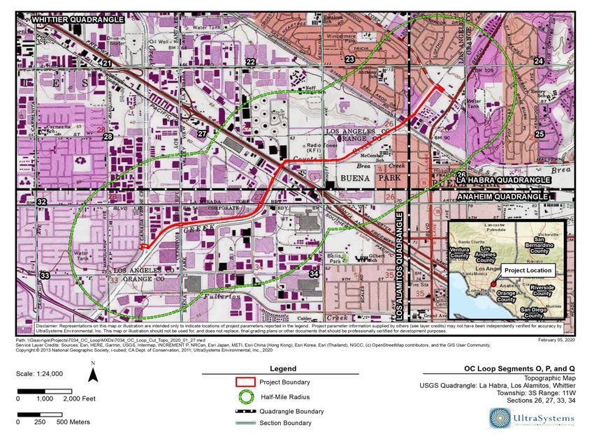
❖ CULTURAL RESOURCES INVENTORY ❖

                                 PHASE I
                      CULTURAL RESOURCES INVENTORY
                                            FOR THE

             OC LOOP SEGMENTS O, P AND Q PROJECT
         ORANGE COUNTY PUBLIC WORKS, ORANGE COUNTY,
                         CALIFORNIA

                          Sarmad Farjo, Principal, PE, ENV SP
                                          GHD
                              320 Goddard Way, Suite 200
                                Irvine, California 92618

                                       Prepared by:
                                  Stephen O’Neil, M.A., RPA
                                 Megan Black Doukakis, M.A.
                                       Lisa Ahn, B.A.

                            UltraSystems Environmental Inc.
                                  16431 Scientific Way
                                    Irvine, CA 92618

                                        August 5, 2021

 Prepared by:                                                 Date:   August 5, 2021

                   Stephen O’Neil, M.A., RPA
                   UltraSystems Environmental Inc.

7034/OC Loop Segments O, P, and Q Project                                              Page i
Cultural Resources Inventory                                                     August 2021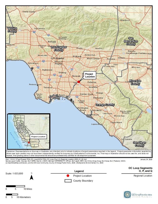
❖ TABLE OF CONTENTS ❖

                                                               TABLE OF CONTENTS
1.0          Introduction .......................................................................................................................................... 1-1
             1.1    Overview.................................................................................................................................................. 1-1
                    1.1.1 Methods .................................................................................................................................... 1-2
                    1.1.2 Disposition of Data .............................................................................................................. 1-2

2.0          Background Settings .......................................................................................................................... 2-1
             2.1   Natural Setting ...................................................................................................................................... 2-1
             2.2   Cultural Setting ..................................................................................................................................... 2-1
                   2.2.1 Prehistoric Context .............................................................................................................. 2-1
                   2.2.2 Ethnohistoric Context......................................................................................................... 2-2
                   2.2.3 Historic Context .................................................................................................................... 2-4

3.0          Research Methods ............................................................................................................................... 3-1
             3.1   Records Search...................................................................................................................................... 3-1
             3.2   Field Survey ............................................................................................................................................ 3-1
             3.3   Native American Outreach ............................................................................................................... 3-1

4.0          Findings .................................................................................................................................................. 4-1
             4.1    Records Search...................................................................................................................................... 4-1
                    4.1.1 Recorded Archaeological Sites ....................................................................................... 4-1
                    4.1.2 Previous Cultural Resource Investigations ............................................................... 4-1
             4.2    Native American Outreach ............................................................................................................... 4-5
             4.3    Pedestrian Survey Results................................................................................................................ 4-5

5.0          Management Considerations .......................................................................................................... 5-1
             5.1  Site Evaluation Criteria ...................................................................................................................... 5-1
             5.2  Potential Effects .................................................................................................................................... 5-1

6.0          Conclusions and Recommendations............................................................................................. 6-1

7.0          References ............................................................................................................................................. 7-1

                                                                               TABLES
Table 4.1-1 - Known Cultural Resources Within a 0.5-Mile Radius .............................................................. 4-1
Table 4.1-2 - Known Cultural Resource Studies Within a 0.5-Mile Radius ................................................ 4-2

                                                                              FIGURES
Figure 4.3-1 – Start of Segment O at North Fork of Coyote Creek Channel; View to the Northwest.. 4-
9
Figure 4.3-2 – West Channel Embankment Between the North Fork and Valley View Avenue Bridge;
View to the Northeast ........................................................................................................................................................ 4-9
Figure 4.3-3 - Coyote Creek Channel Embankment Between Valley View Avenue and Artesia
Boulevard; View to the East ..........................................................................................................................................4-10
Figure 4.3-4 – Artesia Boulevard Bridge; View to the East ............................................................................4-10
Figure 4.3-5 – Homeless Encampment Under Artesia Boulevard Bridge; View to the West ...........4-11

7034/OC Loop Segments O, P, and Q Project                                                                                                                         Page ii
Cultural Resources Inventory                                                                                                                                 August 2021
❖ TABLE OF CONTENTS ❖
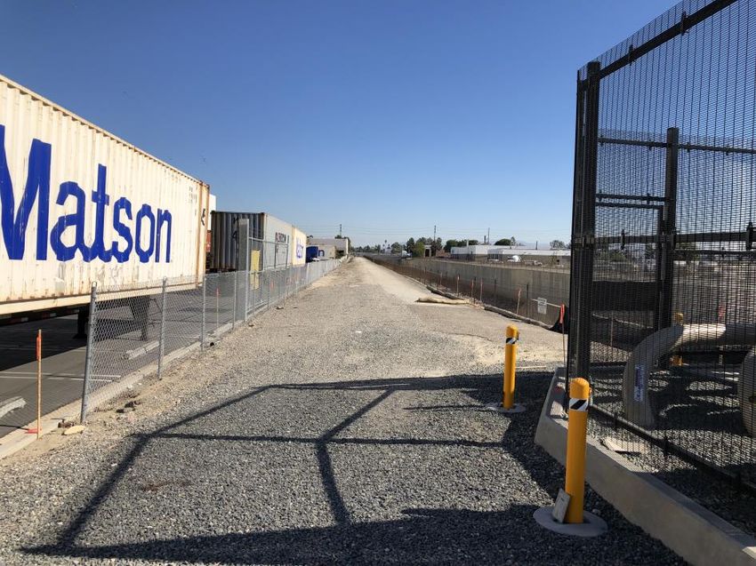
Figure 4.3-6 – Oil Pipeline and Railroad Bridge Over the Channel in Segment P; View to the Northeast
...................................................................................................................................................................................................4-11
Figure 4.3-7 – Railroad Bridge and Oil Pipeline Over Coyote Creek Channel; View to the Southeast
...................................................................................................................................................................................................4-12
Figure 4.3-8 – Large Homeless Encampment at Railroad Bridge, South of S. Firestone Boulevard;
View to the Northeast ......................................................................................................................................................4-12
Figure 4.3-9 – S. Firestone Boulevard Bridge Crossing the Channel; View to the Northeast ...........4-13
Figure 4.3-10 – Construction Work Along the Channel Between S. Firestone Blvd., the Santa Ana
Freeway, and N. Firestone Blvd.; View to the Northeast...................................................................................4-13
Figure 4.3-11 – West Channel Embankment with Commercial Buildings on Both Sides, North of the
Santa Ana Freeway; View to the East ........................................................................................................................4-14
Figure 4.3-12 – Knott Avenue Bridge Over the Channel; View to the East ..............................................4-14
Figure 4.3-13 – Railroad Bridge over the Channel, East of Knott Avenue; View to the East ............4-15
Figure 4.3-14 – Commercial Buildings on the West Side and Residential on the East Side of the
Channel; View to the Northeast ...................................................................................................................................4-15
Figure 4.3-15 – Raiload Bridge Over the Channel South of Stage Road; View to the Northeast .....4-16
Figure 4.3-16 – Stage Road Bridge Over the Coyote Creek Channel; View to the Northeast ...........4-16
Figure 4.3-17 – Landscaping on Both Sides of the Channel Embankments with La Mirada Boulevard
Bridge in Background; View to the Northeast .......................................................................................................4-17
Figure 4.3-18 – Apartment Complex Along East Side of Channel Along Proposed Bike Trail North of
Stage Road; View to the Northeast .............................................................................................................................4-17
Figure 4.3-19 – Industrial Building and Open Space on West Channel Bank South of BNSF Rail Bridge
Along Proposed Bike Trail Bridge; View to the Southwest ..............................................................................4-18
Figure 4.3-20 – Ornamental Landscaping Along Proposed Bike Trail Beside La Mirada Boulevard;
View to the Southeast ......................................................................................................................................................4-18
ATTACHMENTS
Attachment A Project Maps
Attachment B Personnel Background
Attachment C Native American Heritage Commission Records Search and Native American
Contacts
Attachment D CHRIS Records Search
7034/OC Loop Segments O, P, and Q Project Page iii
Cultural Resources Inventory August 2021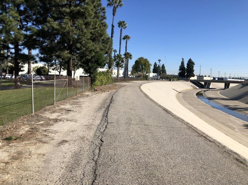
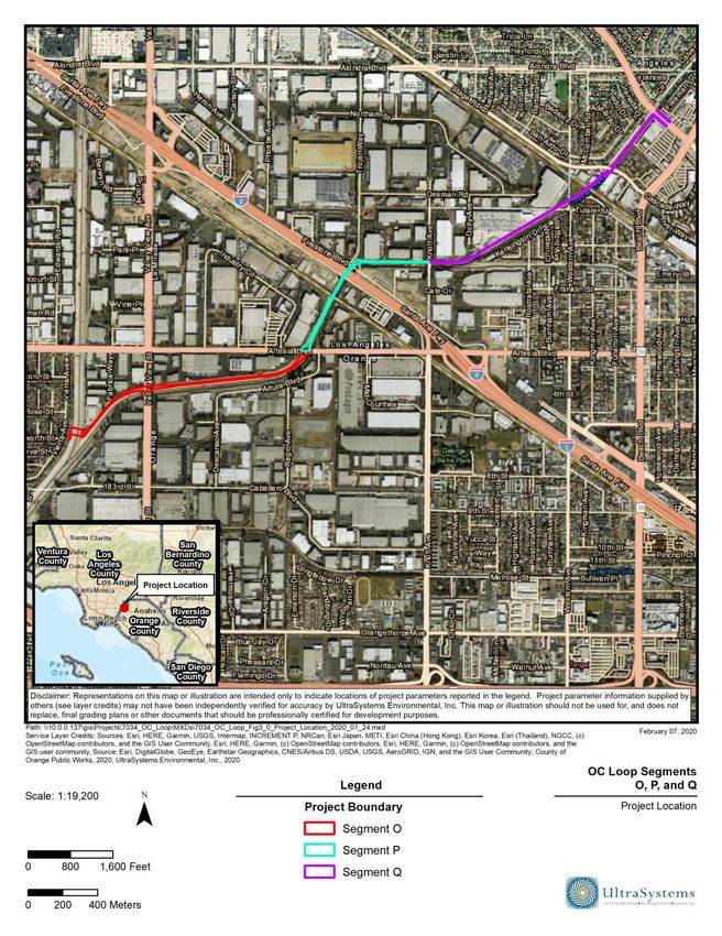
❖ INTRODUCTION ❖

1.0      Introduction

1.1      Overview

This Phase I Cultural Resource Inventory report was prepared by UltraSystems Environmental (UEI)
at the request of Orange County Public Works and GHD for the OC Loop Segments O, P and Q Project
(herein referred to as “project”). The project consists of the construction of a 2.7-mile Class I Bikeway
component of a larger and longer 66-mile regional bikeway corridor called the OC Loop. UEI
conducted this cultural resources study to evaluate the potential presence of prehistoric and historic
resources within the project boundary.

The proposed alignment of the project is located along the northwest Orange County/southwest
Los Angeles County border from its point of origin along the Coyote Creek storm drain channel in the
City of Cerritos on the south to the City of Buena Park to the north (see Attachment A, Figure 1).

The project site includes both hardscaped and landscaped areas. Coyote Creek is a hardscaped flood
control channel consisting of trapezoidal and box-shaped concrete lining. The proposed alignment
is located within a fully urbanized area with commercial and light industry businesses in the south
and central portions of the project area, as well as both single- and multi-family residences in the
northern portion, along the sides of channel. The background research and archival study included
a one-half-mile buffer surrounding the project site’s Area of Potential Effect (APE) (see
Attachment A, Figure 3).

Segments O, P and Q are located along the length of the Coyote Creek flood control channel upstream
and downstream of the Santa Ana Freeway (I-5 Freeway). Segments O, P and Q begin at the existing
Coyote Creek Bikeway (in the cities of Cerritos and La Palma) where the flood channel divides into
north and east forks, running 2.7 miles connecting to another portion of the Coyote Creek Bikeway
at La Mirada Boulevard/Malvern Avenue in the cities of Buena Park and La Mirada (see
Attachment A, Figure 2). The project area is visible on the Los Alamitos, Calif., USGS topographical
quadrangle, R 11 W, T 3 S, in the NE ¼ of the NE ¼, the SE ¼ of the NE ¼, and the SW ¼ of the NE ¼
of Section 33; R 11 W, T 3 S, in the NW ¼ of the NW ¼, the NE ¼ of the NW ¼, and the NW ¼ of the
NE ¼ of Section 34; R 11 W, T 3 S, in the SW ¼ of the SE ¼ of Section 27. The project can also be found
on the Whittier, Calif., USGS topographical quadrangle, R 11 W, T 3 S, in the NW ¼ of the SE ¼, the NE
¼ of the SE ¼, and the SW ¼ of the SE ¼ of Section 27; R 11 W, T 3 S, in the NW ¼ of the SW ¼, the
NE ¼ of the SW ¼, and the SW ¼ of the NE ¼ of Section 26; as well as La Habra, Calif., USGS
topographical quadrangle, R 11 W, T 3 S, in the SW ¼ of the NE ¼, and the NE ¼ of the NE ¼ of Section
26 (see Attachment A, Figure 3).

The proposed alignment of the project includes the construction of a 2.7-mile Class I Bikeway as a
component of the OC Loop. This construction would include installation of two pre-fabricated
pedestrian bridges; construction of six under-crossings at the Valley View Avenue, Artesia Boulevard,
Union Pacific Railroad (UPRR) Industrial Lead, South Firestone, I-5 and North Firestone, and
BNSF/Metrolink Railway Line bridges; and installation of two at-grade crossings at Knott Avenue
and at a potentially non-operational railroad line.

Area of Potential Effect
The APE for the undertaking encompasses the maximum extent of ground disturbance required by
the project design (see Attachment A, Figure 2).

7034/OC Loop Segments O, P, and Q Project                                                      Page 1-1
Cultural Resources Inventory                                                                August 2021
❖ INTRODUCTION ❖

1.1.1    Methods

A cultural resources records search was completed on February 18, 2020 at the South Central Coastal
Information Center (SCCIC) at California State University, Fullerton, which is the local California
Historic Resources Information System (CHRIS) facility. The records search was conducted to
identify previously recorded cultural resources (prehistoric and historic archaeological
sites/isolates, historic buildings, structures, objects, or districts) within the project area and to
determine if previous cultural resource surveys were conducted. The project site and a one-half-mile
buffer zone are included in the search radius for archival studies. These records included a review of
previously recorded prehistoric and historic archaeological resources and a review of listed cultural
resource survey reports within that same geographical area.

Stephen O’Neil, M.A., RPA, contacted the Native American Heritage Commission (NAHC) and
requested a Sacred Lands File (SLF) search as well as a list of interested local tribal organizations and
potentially affiliated Native American individuals. The identified parties were contacted in outreach
to Native American tribal organizations. The cultural resources record search was conducted on
February 18, 2020 by Mrs. Megan Black Doukakis, M.A., and an intensive pedestrian cultural
resources survey was conducted by Mr. O’Neil on February 6, 2020 with a supplemental survey on
August 3, 2021. Mr. O’Neil served as the Principal Investigator, who qualifies as Principal Prehistoric
Archaeologist and Historic Archaeologist per United States Secretary of the Interior Standards (see
Attachment B).

1.1.2    Disposition of Data

This report will be filed with the SCCIC at California State University, Fullerton; the County of Orange;
and UEI, Irvine, California. All field notes and other documentation related to the study will remain
on file at the Irvine office of UEI.

7034/OC Loop Segments O, P, and Q Project                                                      Page 1-2
Cultural Resources Inventory                                                                August 2021
❖ SETTINGS ❖

2.0        Background Settings

2.1        Natural Setting

The City of Buena Park is located in the northern portion of Orange County, and the cities of La Mirada
and Cerritos are located in the southeastern portion of Los Angeles County. All three cities are within
the Los Angeles Basin which is an open plain. This region is quite flat with the project site’s elevation
at approximately 70 feet average mean sea level (AMSL). The region’s environment is characterized
by a warm-summer Mediterranean climate, with the average maximum temperature in July reaching
82°F (degrees Fahrenheit) and the average minimum temperature in January at around 66°F. Rainfall
is typically less than 14 inches annually (Weatherspark.com, 2020).

The surface geology of the project consists of younger Quaternary Alluvium with older Quaternary
Alluvium at the very most northern portion. Both of the deposits are derived as alluvial fan deposits
from the Puente Hills to the north from Coyote Creek that is adjacent to almost all of the proposed
project area (McLeod, 2020:1).

2.2        Cultural Setting

2.2.1      Prehistoric Context

The term "prehistoric period" refers to the period of pre-contact Native California lifeways and
traditions prior to the arrival of Euro-Americans.

It is widely acknowledged that human occupation in the Americas began about 13,000 or more years
ago (all dates presented here are calibrated radiocarbon ages or calendar dates). However, recent
discoveries in areas outside of California have pushed that age back several thousand years more to
about 15,000 or even perhaps up to nearly 20,000 years ago (Smith and Barker, 2017).

To describe and understand the cultural processes that occurred during prehistory, archaeologists
have routinely developed a number of chronological frameworks to correlate technological and
cultural changes recognized in the archaeological record. These summaries bracket certain time
spans into distinct archaeological horizons, traditions, complexes, and phases.

There are many such models even for the various sub-regions of Southern California (cf. Grayson,
2011; Warren, 1984; Jones and Klar, 2007). Given the variety of environments and the mosaic of
diverse cultures within California, prehistory is typically divided into specific sub-regions that
include: the Interior of Southeastern California and the Mojave Desert (Warren and Crabtree, 1986)
and San Diego and the Colorado Desert (Meighan, 1954; True, 1958, 1970).

Many archaeologists tend to follow the regional syntheses adapted from a scheme developed by
William J. Wallace in 1955 and modified by others (Wallace, 1978; Warren, 1968; Chartkoff and
Chartkoff, 1984; Moratto 1984; Sutton et al., 2007 and others). Although the beginning and ending
dates vary, the general framework of prehistory in the Southern California area consists of the
following four periods:

      •   Paleoindian and Lake Mojave Periods [Pleistocene and Early Holocene] (ca. 11000 B.C. to
          6000 B.C.). This time period is characterized by highly mobile foraging strategies and a broad
          spectrum of subsistence pursuits. These earliest expressions of aboriginal occupation in
          America were marked by the use of large dart or spear points (Fluted and Concave Base

7034/OC Loop Segments O, P, and Q Project                                                      Page 2-1
Cultural Resources Inventory                                                                August 2021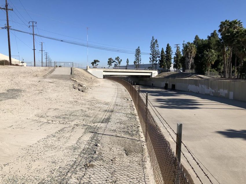
❖ SETTINGS ❖

        Points) that are an element of the Western Clovis expression. Following the earliest portions
        of this time span there was a change in climate coincident with the retreat of the glaciers.
        Large bodies of water existed and lakeside aboriginal adaptations were common. Large
        stemmed points (Western Stemmed Series – Lake Mojave and Silver Lake point types) were
        accompanied by a wide variety of formalized stone tools and were employed with the aid of
        atlatls (dart throwing boards). The latter archaeological materials are thought to be
        representative of an adaptation that was in part focused on lacustrine and riverine
        environments.

   •    Millingstone Horizon [Middle Holocene] (ca. 6000 B.C. to A.D. 1000). During this time span
        mobile hunter-gatherers evolved and became more sedentary. Certain plant foods and small
        game animals came to the forefront of indigenous subsistence strategies. This prehistoric
        cultural expression is often notable for its large assemblage of millingstones. These are
        especially well-made, deep-basin metates accompanied by formalized, portable handstones
        (manos). Additionally, the prehistoric cultural assemblage of this time period is dominated
        by an abundance of scraping tools (including scraper planes and pounding/pulping
        implements), with only a slight representation of dart tipped - projectile points (Pinto, Elko
        and Gypsum types).

   •    Late Prehistoric Period (ca. A.D. 1000 to 1500). Following the Millingstone Horizon were
        cultures that appeared to have a much more complex sociopolitical organization, more
        diversified subsistence base and exhibited an extensive use of the bow and arrow. Small, light
        arrow points (Rose Spring Series), and, later, pottery mark this period along with the full
        development of regional Native cultures and tribal territories.

   •    Protohistoric Period (ca. A.D. 1500 to 1700s). This final cultural period ushered in
        long-distance contacts with Europeans, and thereby led to the Historic Period (ca. A.D. 1700
        to contemporary times). Small arrow points recognized as Desert Side-notched and
        Cottonwood forms are a hallmark of this time period.

2.2.2    Ethnohistoric Context

The project lies within the territory of the Gabrielino (Tongva) ethnolinguistic group (Bean and
Smith, 1978:538), who speak a language classified as a member of the Uto-Aztecan language family.
This language is further affiliated as an element of the Northern Takic Branch of that linguistic group
(Golla, 2011:179).

The Gabrielino, with the Chumash, were considered the most populous, wealthiest, and therefore
most powerful ethnic nationalities in aboriginal Southern California (Bean and Smith, 1978:538).
Unfortunately, most Gabrielino cultural practices had declined before systematic ethnographic
studies were instituted. Today, the leading sources on Gabrielino culture are Bean and Smith (1978),
Johnson (1962), and McCawley (1996).

According to the recent research, Takic groups were not the first inhabitants of the region.
Archaeologists suggest that a Takic in-migration may have occurred as early as 2,000 years ago,
replacing or intermarrying with a more ancient indigenous people represented by speakers of a
Hokan language (Howard and Raab, 1993; Porcasi, 1998). By the time of European contact, the
Gabrielino territory included the southern Channel Islands and the Los Angeles Basin. Their territory
reached east into the present-day San Bernardino-Riverside area and south to the San Joaquin Hills
in central Orange County.

7034/OC Loop Segments O, P, and Q Project                                                     Page 2-2
Cultural Resources Inventory                                                               August 2021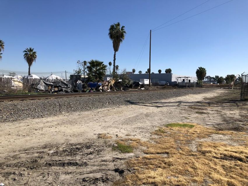
❖ SETTINGS ❖

Different groups of Gabrielino adopted several subsistence strategies, based on gathering, hunting,
and fishing. Because of the similarities to other Southern California tribes in economic activities,
inland Gabrielino groups' industrial arts, exemplified by basket weaving, exhibited an affinity with
those of their neighbors (Kroeber, 1925). Coastal Gabrielino material culture, on the other hand,
reflected an elaborately developed artisanship most recognized through the medium of steatite,
which was rivaled by few other groups in Southern California.

The intricacies of Gabrielino social organization are not well known. There appeared to have been at
least three hierarchically ordered social classes, topped with an elite consisting of the chiefs, their
immediate families, and other ceremonial specialists (Bean and Smith, 1978). Clans owned land, and
property boundaries were marked by the clan's personalized symbol. Villages were politically
autonomous, composed of non-localized lineages, each with its own leader. The dominant lineage's
leader was usually the village chief, whose office was generally hereditary through the male line.
Occasionally several villages were allied under the leadership of a single chief. The villages frequently
engaged in warfare against one another, resulting in what some consider to be a state of constant
enmity between coastal and inland groups.

The first Franciscan establishment in Gabrielino territory and the broader region was Mission
San Gabriel, founded in A.D. 1772. Priests from the mission proselytized the Tongva throughout the
Los Angeles Basin. As early as 1542, however, the Gabrielino were in peripheral contact with the
Spanish during the historic expedition of Juan Rodríguez Cabrillo. However, it was not until 1769 that
the Spaniards took steps to colonize the territory of aboriginal Californians. Within a few decades,
most of the Gabrielino were incorporated into Mission San Gabriel and other missions in Southern
California (Engelhardt, 1931). Due to introduced diseases, dietary deficiencies, and forceful reduccion
(removal of non-agrarian Native populations to the mission compound), Gabrielino population
dwindled rapidly from these impacts. By 1900, the Gabrielino community had almost ceased to exist
as a culturally identifiable group. In the late 20th century, however, a renaissance of Native American
activism and cultural revitalization of Gabrielino descendants took place. Among the results of this
movement has been a return to a traditional name for the tribe, the Tongva, which is employed by
several of the bands and organizations representing tribal members. Many of the Tongva bands focus
on maintaining and teaching traditional knowledge, with special focus on language, place names and
natural resources.

The Tongva community of Povuu’nga was situated about seven miles to the southwest along the
San Gabriel River in what is now the City of Long Beach (McCawley, 1996:69-70), near what later
became the headquarters of the Rancho Alamitos. This was a prominent village of the Tongva and a
major trading center. Povuu’nga and the other surrounding villages later contributed converts to
Missions San Gabriel and San Juan Capistrano. Chester King’s map of Takic language speakers’
settlements (2017) suggests that the Tongva village of Jaysobit was associated with the Rancho
Los Coyotes, probably along Coyote Creek approximately one mile north of the project site. Residents
of this village appear in both the Mission San Gabriel and Mission San Juan Capistrano baptismal
registers (Merriam, 1968: 11, 116, 128, and 135) with a combined contribution of 99 neophytes; this
number would have been a fraction of the population during the pre-Contact era. This portion of the
Los Angeles Basin, with the nearby San Gabriel River and Coyote Creek, would have provided a rich
set of both gathering and hunting resources used by the local indigenous communities. Native
American settlement in the immediate area lasted well into the late 19th Century. Two “Indian
Camps” are shown on the “Map of Part of Los Angeles County” prepared around 1870 located “…along
the present course of Coyote Creek northwest of the modern community of Buena Park” (McCawley,
1996:59). These two camps are also shown on the 1873 map of the Abel Sterns Rancho at

7034/OC Loop Segments O, P, and Q Project                                                      Page 2-3
Cultural Resources Inventory                                                                August 2021
❖ SETTINGS ❖

approximately one half to a mile to the northwest and west of the project area (Baker, 1873). These
were likely settlements for Tongva and other southern California Indians who worked in the
surrounding cattle and agricultural farms. To the northwest of the project site were Chokiishnga
along the west bank of the San Gabriel River about five miles to the northwest in Santa Fe Springs,
and the Native “community of Huutgna was also located in this [same] vicinity” (McCawley 1996:58).
In the Los Nietos area of Santa Fe Springs, about six miles to the north, was the village of Naxaaw’nga
which “was lost long ago to a rampaging flood on the San Gabriel River” (McCawley 1996:58), which
demonstrates the wide meanderings of this river and extent of its floodplain. The Puente Hills would
have provided a rich set of both gathering and hunting resources used by the surrounding indigenous
communities.

2.2.3    Historic Context

2.2.3.1 Spanish/Mexican Era

The earliest known direct European involvement with the land that became Buena Park, La Mirada,
and Cerritos occurred in 1784. It was then that Corporal Manuel Nieto, formerly a member of
Don Gaspar de Portolá’s 1769/70 expedition through Alta California, successfully petitioned the
governor of Alta California, Captain Pedro Fages (the two had served together in the Portolá
Expedition) for the right to graze on land that included the Buena Park, La Mirada, and Cerritos area
(Strawther, 2012). The Nieto Tract consisted of all the lands between the San Gabriel and Santa Ana
Rivers, and from the Whittier Hills to the Pacific Ocean (Bandy and Bandy, 1998:188); a full
300,000 acres for pasturage of his horses and cattle. The extent was protested by Mission San Gabriel
and later reduced to a “mere” 167,000 acres, where he and his family lived, grew, built adobe
haciendas through Spanish rule and into the Mexican republic. Following 1832, the Rancho
Los Nietos was divided into five smaller ranchos and given to Nietos’ heirs, each grant still ranging in
tens of thousands of acres. The cities of Buena Park, La Mirada, and Cerritos sit on the portion that
was carved out of what once was the Rancho Los Coyotes, which had been inherited by
Juan Jose Nieto, the eldest son (Bandy and Bandy, 1998:192). Rancho Los Coyotes passed from Nieto
ownership in 1840 to Juan Bautista Leandri, an Italian immigrant, and then on to subsequent owners
and divided into farms during the American era. The modern towns of Cerritos, La Mirada, Stanton,
and Buena Park occupy the lands that were the Rancho Los Coyotes, extending across the Los Angeles
and Orange County border.

Mexico rebelled against Spain in 1810, and by 1821, Mexico, including its California province,
achieved independence. The Mexican Republic began to grant private land to citizens to encourage
emigration to California. Huge land grant ranchos took up large sections of land in California. Ranchos
surrounded the mission lands in all directions. The Mission San Gabriel lands were used for the
support of the mission and provided for the large population of Tongva Native Americans. The
mission lands were held in trust for Native peoples by the Franciscan missionaries for eventual
redistribution. The lands along the coast, however, were open for early settlement by the colonists
from New Spain.

The Mexican-American War of 1846 saw the invasion of California from both land and sea. Following
several skirmishes in the San Diego and Los Angeles areas, and the capture of the territorial capital
in Monterey, the United States rule was firmly established. Following the rapid influx of population
to the north because of the Gold Rush of 1849, California was made a state in 1850. The economic
and social order was slow to change in the southern portion of the state, however, and rancheros
were left in control of their vast estates through the 1860s. The Los Angeles region, which included
the future Orange County area through the 19th century, was a part of the “Cow Counties” and had

7034/OC Loop Segments O, P, and Q Project                                                     Page 2-4
Cultural Resources Inventory                                                               August 2021
❖ SETTINGS ❖

little representation in the state legislature because of the sparse population. This allowed the
predominantly Anglo population of the north to pass laws aimed at breaking up the ranches for
settlement by Eastern farmers and, coupled with devastating droughts that crippled many livestock
raisers, their dismemberment soon came. This helped pave the way for the “Boom of the Eighties”
which saw an influx of people from the rest of the United States and the beginning of many of the
towns we see today (Dumke, 1944). This was the first spurt of growth for Los Angeles, and smaller
communities in the region started to form to the west, east, and the south such as Anaheim, Tustin,
and Santa Ana, serving as residential and commercial centers for the surrounding farms and orchards
on the plains. Portions of the remaining ranchos, especially in the hill terrain, remained used largely
for cattle ranching.

2.2.3.2 The American Period to Founding of Buena Park, La Mirada, and Cerritos

The growth of communities in the southeastern part of Los Angeles County initiated a desire for a
new county. In 1889, these communities formed Orange County, which included the area that became
Buena Park. The areas that would become La Mirada and Cerritos remained part of Los Angeles
County. Coyote Creek became the northwestern border for Orange County and southeastern border
for Los Angeles County (Armor, 1921).

Buena Park

In 1860, Abel Stearns, a business man from Massachusetts, had acquired Rancho Los Coyotes along
with Rancho La Habra, Rancho San Juan Cajón de Santa Ana, Rancho Las Bolsas, Rancho La Bolsa
Chica, Rancho Jurupa and Rancho La Sierra (Buena Park History, 2020). Forming what was briefly
known as “the Stearns Rancho,” these holdings were purchased with the plan to resell portions as
large and small tracts to be turned into farms and subdivisions. James A. Whitaker, a wholesale
grocer from Chicago, purchased 690 acres of the Stearns Rancho in 1887. Whitaker intended to create
a cattle ranch, but Santa Fe Railway officials convinced him a better use of the land would be for a
new town (Orange County.net, 2020). There are multiple stories of how Buena Park got its name. It
was said that under the Los Coyotes adobe there was a “spring of good water and grass for animals.
It has been called ‘Plaza Buena’ meaning ‘good place’ or ‘good park’.” (Chamberlin, 1971:7). The other
possibility is that it is named after the eponymous Chicago suburb that the Whitaker family was from
(Brigandi, 2006:13).

Buena Park originally gained recognition as a dairy center and the first industry in the city came with
the opening of The Lily Creamery in 1889 (OrangeCounty.net, 2019). The Pacific Condensed Milk,
Coffee and Canning Co. established the evaporated milk cannery here and it was the first in California
(HMdb.org, 2020). The Bixby family owned and operated the factory from 1896 until it closed in
1907. Later the plant was used as a tomato cannery.

Much of the city’s financial and physical growth is attributed to the Knott Family. Walter and
Cordelia Knott opened a 20-acre berry farm in 1920 and established a roadside stand to sell their
produce along Beach Boulevard (VisitBuenaPark.com, 2020). As their business started growing,
Cordelia opened a tea room where she served and sold jams and jellies. After hearing about a berry
strain that was developed as a cross of blackberries, raspberries and loganberries, Walter Knott
sought out the developer, Rudolph Boysen and his berry plants. Knott was able to plant a specimen
(VisitBuenaPark.com, 2019) which did well, and he soon expanded the crop. Cordelia soon expanded
her tea room by serving biscuits, fried chicken and boysenberry pies. As their popularity grew, Knott
developed the Ghost Town with material from his uncle’s silver mill and part of the actual Calico

7034/OC Loop Segments O, P, and Q Project                                                     Page 2-5
Cultural Resources Inventory                                                               August 2021
❖ SETTINGS ❖

ghost town that he acquired in 1951 (VisitBuenaPark.com, 2020). The city of Buena Park was
incorporated in 1953 (OrangeCounty.net, 2020).

Cerritos

As in Buena Park, the area that would become the City of Cerritos focused on dairy farming through
the late 19th century and into the early 20th century. Originally part of Artesia in Rancho Los Coyotes,
Cerritos sought autonomy in the 1950s. On the southeastern side of Coyote Creek, the city that would
become La Palma incorporated under the name Dairyland and Cypress incorporated under the name
Dairy City. Following the trend of the area, the City of Cerritos incorporated under the name Dairy
Valley in 1956 (Cenovich, 1995).

In the early 1960s, two large freeways were built through the area, Coyote Creek and the San Gabriel
River were undergoing flood control construction, and some parts of the city were re-zoned for
development. With this urbanization, many dairy farms were displaced, and the industry decreased.
In 1967, the City of Dairy Valley changed its name to the City of Cerritos. Despite having been part of
Rancho Los Coyotes, the city took its name from the nearby Cerritos College which, in turn, had taken
its name from Rancho Los Cerritos (Cenovich, 1995).

La Mirada

In 1888, Andrew McNally, co-founder of the Rand McNally Publishing Company, purchased
2,300 acres from the Abel Stearns Rancho Trust in Los Angeles County and became the last private
owner of Rancho Los Coyotes. McNally sold a few 20 acre parcels to ranchers while the rest of the
land was used for the Windermere Ranch (City of La Mirada, 2020). In its heyday the
Windermere Ranch had six hundred acres of olive trees and produced 15% of California’s olive oil
supply, and two hundred acres of lemon trees, as well as alfalfa, grapefruit, and oranges (Discover
La Mirada, 2020).

The area continued to be used for ranches and agriculture until World War II. In 1953, then owner
William “Bill” Neff sold 2,218 acres to the Pioneer Land and Realty Company of Los Angeles which
rapidly constructed 7,800 residences on the land by 1956 (City of La Mirada, 2020). La Mirada was
slated to be one of the nation’s first pre-planned cities, and the post-war population boom of the
1950s brought families to these residences (Discover La Mirada, 2020).

The City of La Mirada was incorporated in 1960 under the name Mirada Hills. The city’s name was
converted to La Mirada after a proposition in the November 1960 elections passed (City of La Mirada,
2020). By this time, the population had grown to 19,455 residents and contained 7.9 square miles
(Discover La Mirada, 2020).

Coyote Creek

Coyote Creek is a tributary of the San Gabriel River Watershed which receives drainage from
Los Angeles County and originates in the San Gabriel Mountains (California Waterboards, 2020).
Coyote Creek originates in the hills of La Habra and empties in Seal Beach. Before flood control
infrastructure was installed, the project area was known for flooding, and Coyote Creek regularly
overflowed into the Hawaiian Gardens area (Cenovich, 1995).

In 1915, California adopted the Los Angeles County Flood Control Act, establishing the Los Angeles
County Flood Control District, after a disastrous regional flood in 1914. This act authorized the

7034/OC Loop Segments O, P, and Q Project                                                     Page 2-6
Cultural Resources Inventory                                                               August 2021
❖ SETTINGS ❖

construction of flood control infrastructure throughout the county, much of which finished
construction in 1937, one year before another large flood in 1938 (LACDPW, 2020; KCET, 2020). A
history of floods from the surrounding tributaries of Coyote Creek necessitated flood control
infrastructure in the project area, which was built during the 1930s and into the 1960s. This included
dams, reservoirs, and encasing the streams of the Coyote Creek watershed in concrete channels
(Cenovich, 1995).

2.2.3.3 Project Site Land Use History

Historic aerial maps for the area, the earliest dating to 1952, show that the project site continued to
be used for farming through the 1950s (NETROnline, 2020). Oil tanks are visible in the aerials from
1953 to 1972, and imprints from the tanks are visible in the 1994 aerial (NETROnline, 2020). The
Santa Ana Branch of the Union Pacific Railroad and the San Diego Branch of the Burlington Northern
Santa Fe Railroad can be seen in all available aerials (NETROnline, 2020). By 1963, the Interstate 5
(I-5) Freeway had been constructed, and Coyote Creek had been encased in a concrete channel
(NETROnline, 2020). Although much of the surrounding land is still agricultural in the 1963 aerial,
structures can be seen where the I-5 Freeway intersects Coyote Creek, and residential development
is visible in the City of Buena Park (NETROnline, 2020). By 1972, the entire area had been developed
for commercial and residential use (NETROnline, 2020).

Topographic maps are also available for the project area with the earliest in 1896 (USGS, 1896). The
1896 through 1902 topographic maps do not show any buildings present on or near the immediate
project area aside from the two railroads (USGS, 1896, 1899, 1902). In the 1923 topographic map, oil
tanks for the “Standard Oil Co. Pumping Station” are visible to the north-northwest of the project site
(USGS, 1923). In the 1942 through 1945 maps, buildings are present near the southwest end of the
project site (USGS, 1942, 1945). By the time of the 1964 and 1965 maps, the immediate project area
has been fully developed and multiple structures are present along the I-5 Freeway (USGS, 1965).

7034/OC Loop Segments O, P, and Q Project                                                     Page 2-7
Cultural Resources Inventory                                                               August 2021
❖ RESEARCH METHODS ❖

3.0      Research Methods

This cultural resources inventory and related archival research included a background cultural
resources records check (archival research) at the SCCIC, California State University, Fullerton.
Additionally, a search of their SLF was requested from the NAHC, as well as a list of local
Native American groups and individuals for outreach. Finally, a pedestrian cultural resource survey
of the entire project site was conducted.

3.1      Records Search

A cultural resource records search to identify cultural resources on or near the project site was
completed by Megan Black Doukakis at the SCCIC on February 18, 2020. The local CHRIS facility for
Orange County, maintained at the SCCIC, was also reviewed to identify resources that have been
previously evaluated for historic significance, as well as to identify any previous completed cultural
resources survey reports for the area.

The official records and maps were searched and reviewed for cultural resources and surveys in
Orange County, National Register of Historic Places; Listed Properties and Determined Eligible
Properties (2012); and the California Register of Historical Resources (2012).

For the current study, the scope of the records search included a 0.5-mile buffer zone from the
project’s footprint (see Attachment A, Figure 3). The research effort was completed to assess the
sensitivity of the project site for both surface and subsurface cultural resources and to assist in
determining the potential to encounter such resources, especially prehistoric—i.e.,
Native American—cultural remains, during earth-moving activities associated with the proposed
project.

3.2      Field Survey

On February 6, 2020 and August 3, 2021, archaeologist Stephen O’Neil visited the project site to
conduct a pedestrian survey, during which the project site was carefully inspected for any indication
of human activities dating to the prehistoric or historic periods (i.e., 50 years or older).

3.3      Native American Outreach

On January 28, 2020, Mr. O’Neil contacted the NAHC via email notifying them of the project activities,
requesting a search of their SLF, and requesting a list of local tribal organizations and individuals to
contact for project outreach. The NAHC replied on February 11, 2020 with a letter dated the same
day reporting on the SLF search findings and a list of five individuals to contact representing five
tribal organizations. Letters to local tribes were sent on February 17, 2020 to all of the tribal
organizations and individuals listed in the NAHC February 11, 2020 letter (Attachment C).

7034/OC Loop Segments O, P, and Q Project                                                     Page 3-1
Cultural Resources Inventory                                                               August 2021
❖ FINDINGS ❖

4.0      Findings

4.1      Records Search

4.1.1    Recorded Archaeological Sites

Based on the cultural resources records search, it was determined that two cultural resources have
been previously recorded within the project site boundary. Within the half-mile buffer zone but
outside the project boundary there have been four recorded historic-era cultural resources, one of
which includes possible paleontological resources; there have been no prehistoric sources recorded
here. Table 4.1-1 summarizes the resources found within the half-mile buffer zone and within the
project site boundary.

The two historic cultural resources found within the project site boundary are segments of the
Union Pacific Railroad and the Burlington Northern Santa Fe Railway. These segments run southeast
to northwest across the Los Angeles and Orange County border, resulting in both a Los Angeles and
Orange County site number. The project site is located along the county border with the Union Pacific
Railroad (19-186110/30-176630) intersecting Segment P and the Burlington Northern Santa Fe
Railway (19-186804/30-176663) intersecting Segment Q (Ashkar, 1999; Ballester and Tang, 2002).

The Union Pacific Railroad site (19-186110/30-176630) intersects Segment P in Los Angeles County.
This portion of the Union Pacific Railroad has been evaluated and determined to be eligible for the
National Register of Historic Places (NRHP) listing. It was not assessed for eligibility under the
California Register of Historical Resources (CRHR) (Ashkar, 1999).

The Burlington Northern Santa Fe (BNSF) Railway (19-186804/30-176663) intersects Segment Q in
Orange County. This segment of the BNSF Railway has been evaluated for the NRHP and determined
to not meet the criteria to qualify. It was not assessed for eligibility under the CRHR (Ballester and
Tang, 2002).

                                    Table 4.1-1
                  KNOWN CULTURAL RESOURCES WITHIN A 0.5-MILE RADIUS

  Site Number        Author(s)          Date          Type                      Description
  19-186110 /                                                       Segment of the Union Pacific
                      S. Ashkar        1999          Historic
   30-176630                                                        Railroad.
                   Daniel Ballester
  19-186804 /                                                       Segment of the Burlington Northern
                   and Bai “Tom”       2002          Historic
   30-176663                                                        Santa Fe Railway
                        Tang
                                                                    Historic two-story KFI transmitter
   19-187549       Scott M. Hudlow     2006          Historic
                                                                    building.
                                                                    Two privies, historic trash pits, and
                                                     Historic /
   30-120020          Unknown         Unknown                       possible segments of the La Habra
                                                  Paleontological
                                                                    fossil bearing.

4.1.2    Previous Cultural Resource Investigations

According to the records at the SCCIC, there have been 20 previous cultural resource studies within
a half-mile buffer of the project site (Table 4.1-2) (see Attachment D). Ten of these studies are

7034/OC Loop Segments O, P, and Q Project                                                        Page 4-1
Cultural Resources Inventory                                                                  August 2021
❖ FINDINGS ❖
located outside of the project boundary while ten of them, LA-07871/OR-03298,
LA-03356/OR-00814, LA-07844/OR-03276, LA-08255/OR-03373, and LA-04834/OR-02094,
intersected the project site itself. The ten studies within the project site concerned potential
placement of wireless facilities, Metrolink improvements, or I-5 Santa Ana Freeway improvements
and had linear study areas. These study areas intersect Segments P and Q along the Los Angeles
County and Orange County border, resulting in both Los Angeles County and Orange County report
numbers for each study.
Table 4.1-2
KNOWN CULTURAL RESOURCE STUDIES WITHIN A 0.5-MILE RADIUS
Report
Author(s) Date Title Resources
Number
Archaeological Survey Report for
the Route I-5 Santa Ana
LA-03356/ Transportation Corridor Route 405
Romani, John F. 1982 NA
OR-00814 in Orange County to Route 605 in
Los Angeles County P.m.
21.30/44.38 0.00/6.385
Negative Phase I Archaeological
Survey of 3.4 Acres West of Trojan
Way Street From Desman Road to
LA-03371 Maki, Mary K. 1996 NA
Firestone Boulevard, City of La
Mirada, Los Angeles County,
California
Cultural Resources Records Search
and Survey Report for a Pacific Bell
Mason, Roger D. and Mobile Services
LA-04152 1998 NA
Wayne H. Bonner Telecommunications Facility:
La-316-03 City of La Mirada,
California
Cultural Resources Inventory
Report for Williams
Communications, Inc. Proposed 19-186110,
LA-04834/
Ashkar, Shahira 1999 Fiber Optic Cable System 19-186111,
OR-02094
Installation Project, Los Angeles to 30-176630
Anaheim, Los Angeles and Orange
Counties
Cultural Resource Assessment
LA-05199 Duke, Curt 2001 Cingular Wireless Facility No. NA
Sm 083-02 Los Angeles County, Ca
Cultural Resource Assessment
LA-06174 Duke, Curt 2001 Cingular Wireless Facility No. NA
Sm 083-02 Los Angeles County, Ca
A Phase I Cultural Resources
LA-07730 Hudlow, Scott M. 2006 Survey for KFI Tower Project, City 19-187549
of La Mirada, California
Historic Architectural Survey
LA-07844/
Kane, Diane 1998 Report for I-5 HOV Lane
OR-03276
Improvement Project
7034/OC Loop Segments O, P, and Q Project Page 4-2
Cultural Resources Inventory August 2021❖ FINDINGS ❖
Report
Author(s) Date Title Resources
Number
19-186753,
19-186754,
19-186755,
19-186756,
19-186757,
19-186758,
19-186759,
19-186760,
19-186761,
19-186762,
19-186763,
19-186764,
19-186765,
19-186766,
19-186767,
19-186768,
19-186769,
19-186770,
19-186771,
19-186772,
19-186773,
19-186774,
Historical Resource Compliance
19-186775,
Report – Third Main Track and
19-186776,
Grade Separation Project Hobart
19-186777,
LA-07871 / Tang, Bai “Tom” and (mp 148.9) to Basta (mp 163.3),
2003 19-186778,
OR-03298 Teresa Woodard BNSF/Metrolink East-west Main
19-186779,
Line Railroad Track, Vernon to
19-186780,
Fullerton, Los Angeles and Orange
19-186781,
Counties, California
19-186782,
19-186783,
19-186784,
19-186785,
19-186786,
19-186787,
19-186788,
19-186789,
19-186790,
19-186791,
19-186792,
19-186793,
19-186794,
19-186795,
19-186796,
19-186797,
19-186798,
19-186799,
19-186800,
19-186801,
19-186804,
30-176663
7034/OC Loop Segments O, P, and Q Project Page 4-3
Cultural Resources Inventory August 2021❖ FINDINGS ❖
Report
Author(s) Date Title Resources
Number
Cultural Resources Final Report of
Monitoring and Findings for the
LA-08255 / Arrington, Cindy and
2006 Qwest Network Construction NA
OR-03373 Nancy Sikes
Project State of California: Volumes
I and II
Cultural Resources Records Search
and Site Visit Results for Royal
Street Communications, LLC 19-186804,
LA-09117 Bonner, Wayne H. 2007
Candidate LA0858D (Messe, Inc.), 19-187549
16404 Knott Avenue, La Mirada,
Los Angeles County, California
Section 106 Consultation for
Installation of Communications
LA-11498 Meyer, Donna 2011 Equipment for Integrated Public NA
Alert and Warning System,
La Mirada, Los Angeles County
Archaeological Survey Report on a
OR-00121 Desautels, Roger J. 1976 Parcel of Land Located in the City NA
of La Palma, Orange County
Cultural Resources Report on an
Archaeological, Historical and
Paleontological Records Search
OR-00424 Desautels, Roger J. 1979 NA
and Survey of Approximately
3 Acres of Property Located in
Buena Park, California
Cultural Resources Record Search
and Literature Review Report for a
Pacific Bell Mobile Services
OR-01671 Mason, Roger D. 1997 NA
Telecommunications Facility
Cm 085-04, in the City of La Palma,
California
Cultural Resource Assessment
Cingular Wireless Facility No.
OR-02608 Duke, Curt 2003 NA
Cm 085-04 Orange County,
California
Request for SHPO Review of FCC
OR-02609 Duke, Curt 2003 Undertaking 5600 Fresca Dr., NA
La Palma, California
Records Search Results for Sprint
PCS Facility OG54XC458A (Gordon
OR-02793 Bonner, Wayne H. 2001 Square Shopping Center), 5301 NA
Beach Blvd., Buena Park, Orange
County, California
Cultural Resource Assessment
AT&T Wireless Services Facility
OR-02806 Duke, Curt 2002 NA
No. 13018a Orange County,
California
7034/OC Loop Segments O, P, and Q Project Page 4-4
Cultural Resources Inventory August 2021❖ FINDINGS ❖
Report
Author(s) Date Title Resources
Number
Report of Archaeological
Assessment for Beach
OR-03045 Demcak, Carol R. 2005 Boulevard/Malvern Avenue NA
Intersection Improvement, City of
Buena Park, California
4.2 Native American Outreach
On January 28, 2020, Mr. O’Neil contacted the NAHC via email and facsimile notifying them of the
project, requesting a search of their SLF and asking for a list of local tribal organizations and
individuals to contact for project outreach. The results of the search request were received
February 11, 2020, at the office of UEI from Mr. Steven Quinn, Associate Governmental Program
Analyst. The NAHC letter stated that “A record search of the Native American Heritage Commission
(NAHC) Sacred Lands File (SLF) was completed for the information you have submitted for the above
referenced project. The results were negative [emphasis in the original].” (See Attachment C.)
UEI prepared letters to each of the five tribal contacts representing five tribal organizations
describing the project and a map showing the project's location, requesting a reply if they have
knowledge of cultural resources in the area, and asked if they had any questions or concerns
regarding the project (see Attachment C). On February 17, 2020, Mr. O’Neil mailed the letters with
accompanying maps to all five tribal contacts, and also emailed identical letters and maps to each of
the five tribal contacts for which email addresses were known, as well as sending facsimiles on
February 17, 2020 to the two tribes with facsimile capability. There have been no responses to the
letters and emails to date.
Following up on the initial letter and email contacts, telephone calls were conducted on April 2, 2020,
to complete the outreach process. These calls were to the five tribal contacts who had not responded
to UEI mailing and email. Four telephone calls were placed with no answer and so messages were
left describing the project and requesting a response. These were to Chairperson Sandonne Goad,
Chairperson of the Gabrielino/Tongva Nation; Mr. Charles Alvarez of the Gabrieleno-Tongva Tribe;
Chairperson Andrew Salas of the Gabrieleño-Tongva Tribe; and Chairperson Anthony Morales of the
Gabrieleno/Tongva San Gabriel Band of Mission Indians. There have been no responses to date of
the preparation of this report from these individuals.
During the telephone calls of April 2, 2020, Chairperson Robert Dorame of the Gabrielino Tongva
Indians of California Tribal Council asked for us to resend the material to his email and if we do not
receive a response then they have no concerns with the project. There have been no further
responses from this tribe to date (see Attachment C).
4.3 Pedestrian Survey Results
A cultural resources pedestrian survey was conducted along the proposed alignment (see
Attachment A, Figure 2) on February 6, 2020 by Mr. Stephen O’Neil, followed by a supplemental
survey on August 3, 2021. The survey consisted of walking, visually inspecting, and photographing
the exposed ground surface and landscaped areas of the project site using standard archaeological
procedures and techniques. Access to the channel is limited to gates at several of the road crossings,
which are generally locked. On the day the cultural resources survey was conducted, Mr. Camden
7034/OC Loop Segments O, P, and Q Project Page 4-5
Cultural Resources Inventory August 2021❖ FINDINGS ❖ Cabrinha and his crew were conducting their engineering survey of portions of the channel for the OC Loop Project along the entire project length and provided gate access at several points. Survey of the ground surface was conducted in linear and opportunistic manner; walking transects over the north and west channel embankment above the channel itself. The embankment ranged from approximately 20 to 60 feet wide with an asphalt road approximately ten feet wide along the channel-side edge. The asphalt road was occasionally well maintained, but frequently was not and was more gravely in constitution. There was a boundary chain-link fence along the entire boundary line on the north/west side. The embankment from the road to the fence was sometimes level, and occasionally sloped up to the fence, and ranged from ten feet to 55 feet beyond the road. This open area was consistently devoid of vegetation. The survey started at the southern end of Segment O (see Attachment A, Figure 2, western red portion), where the main Coyote Creek Channel is joined by the North Fork – Coyote Creek. A pedestrian bridge would be built across the North Fork to the main channel side (Figure 4.3-1). The west side of the channel was walked northward, observing commercial buildings adjacent to the embankment up to the Valley View Avenue bridge crossing the channel (Figure 4.3-2) where there would be a bicycle trail undercrossing. Markings on this bridge provided its Caltrans identification number B1658. The transect was continued eastward. Structures lining the channel boundary between Valley View Avenue and the end of Segment O at Artesia Boulevard are industrial and commercial businesses, including large warehouse structures (Figure 4.3-3) on both sides of the creek. The Artesia Boulevard bridge (Figure 4.3-4), at the south end of Segment P (see Attachment A, Figure 2, central green portion) was originally to have a bicycle trail undercrossing. Markings on this bridge provided its Caltrans identification number 3145. This design was reconfigured in July 2021 and changed to a tunnel underneath Artesia Boulevard itself immediately west of the channel bridge, and so this surface area was surveyed on August 34, 2021. While continuing the survey transect along the narrow, concrete walkway under the bridge, a small encampment (representing one or two residents) was observed (Figure 4.3-5). The transect was continued northeastward along the channel embankment until it reached an oil pipeline crossing and the adjacent Union Pacific Railroad bridge crossing, both of which block transit along the channel embankment (Figure 4.3-6 and Figure 4.3-7). At this point there would be a bicycle trail undercrossing (or alternatively a pedestrian/cyclist truss bridge); however, at present there is no flat embankment between the pipeline and railroad, and one has to go up to the railroad crossing level and cross the railroad tracks, and then go back down to the level of the embankment on the north side (railroad bridges had no Caltrans identification number). Walking over this railroad crossing, a medium-sized encampment of approximately five makeshift lodging structures was observed at the northern corner of the crossing (Figure 4.3-8); no one appeared to be home at the time. Within approximately 425 feet to the north of the railroad bridge the S. Firestone Boulevard bridge crosses the Coyote Creek Channel (Figure 4.3-9). This road lies adjacent and parallel to the Santa Ana/I-5 Freeway on the south side of the freeway, with N. Firestone Boulevard adjacent to the freeway on the north side. These three bridges would have a single bicycle trail undercrossing them all. Markings on the S. Firestone Boulevard bridge indicate that it was built in 1950, and provided its Caltrans identification number B1011. Due to active construction on the interface between the S. Firestone Boulevard bridge and the I-5 Freeway (Figure 4.3-10) at the time of the survey, it was not possible to continue the survey along the channel embankment below these three bridges or to look for markings indicating the year of construction or designation for the freeway bridge. 7034/OC Loop Segments O, P, and Q Project Page 4-6 Cultural Resources Inventory August 2021
You can also read