Western Davenport Water Allocation Plan 2018 2021 - Page 1 of 80
←
→
Page content transcription
If your browser does not render page correctly, please read the page content below
Western Davenport Water Allocation Plan 2018 – 2021

                                       Page 1 of 80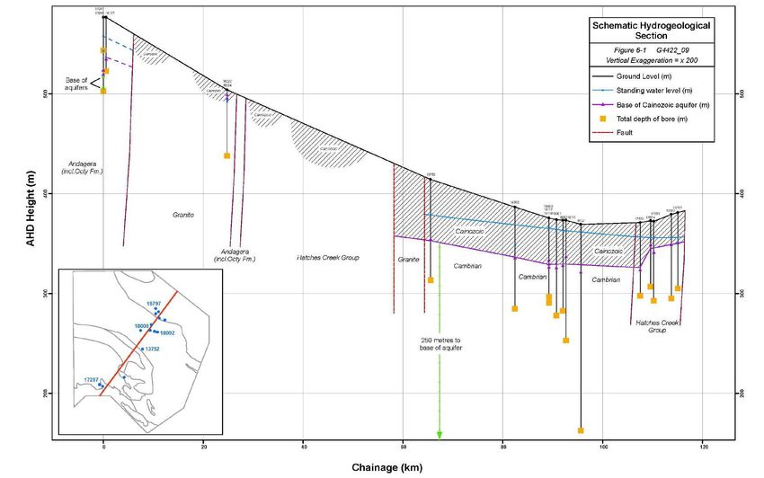
Western Davenport Water Allocation Plan 2018 – 2021

Department of Environment and Natural Resources
Water Resources Division
PO Box 2533
ALICE SPRINGS NT 0871

© Northern Territory of Australia, 2018

Report No:         30/2018A
ISBN:              9781743501849

To cite this report:

Northern Territory Government (2018) Western Davenport Water Allocation Plan 2018-2021.
     Department of Environment and Natural Resources: Northern Territory, Australia.

This publication and all material forming part of it is copyright belonging to the Northern Territory.
You may use this publication for your personal, non-commercial use, provided that an appropriate
acknowledgement is made and the material is not altered in any way. Subject to the fair dealing
provisions of the Copyright Act 1968 (Cwlth), you must not make any other use of this publication
(including copying or reproducing it or part of it in any way) unless you have the written permission
of the Northern Territory to do so.

Front page photo: A watermelon at Desert Springs farm near Ali Curung.

Disclaimer: The Northern Territory does not warrant that this publication or any part of it is correct
or complete. No reliance or actions should be made on the information contained within the
publication without seeking prior expert professional, scientific and technical advice. To the extent
permitted by law, the Northern Territory (including its employees and agents) excludes all liability to
any person for any consequences, including but not limited to all losses, damages, costs, expenses
and other compensation, arising directly or indirectly from using, in part or in whole, any information
or material contained in this publication.

Page 2 of 80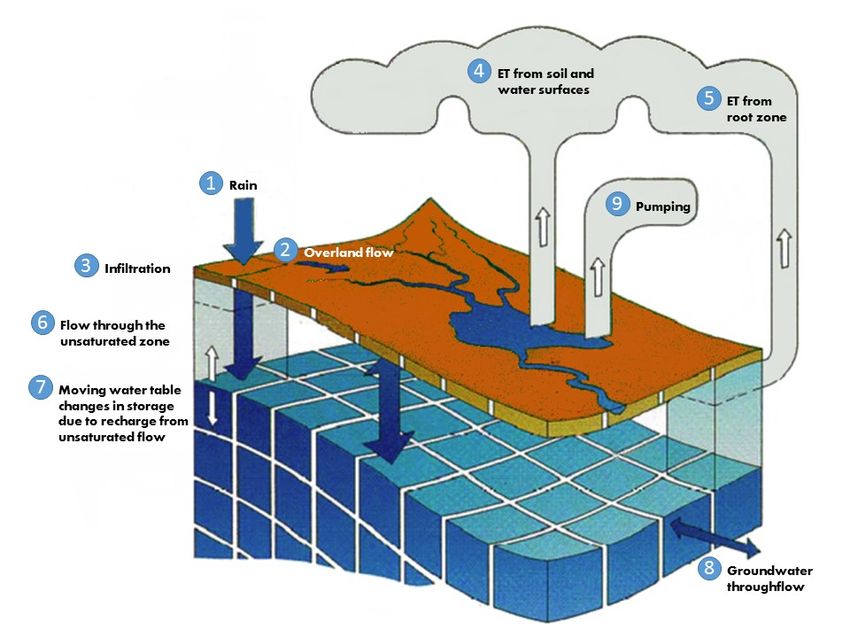
Western Davenport Water Allocation Plan 2018 – 2021

                                                                    Contents
1   Summary ........................................................................................................................................................... 6
    1.1    Estimated Sustainable Yield (ESY) ............................................................................................... 7
           1.1.1          Surface water resources ................................................................................................ 7
           1.1.2          Groundwater resources ................................................................................................. 7
2   Introduction .................................................................................................................................................... 11
    2.1      Western Davenport Water Allocation Plan............................................................................. 11
    2.2      The Western Davenport WAP area .......................................................................................... 11
             2.2.1        WAP area........................................................................................................................ 11
             2.2.2        Description ..................................................................................................................... 11
             2.2.3        Population and land uses............................................................................................. 11
    2.3      Term of the WAP .......................................................................................................................... 11
    2.4      Context ........................................................................................................................................... 14
    2.5      WAP development process ........................................................................................................ 15
3   Purpose and Objectives ............................................................................................................................... 16
4   Water resources (supply and condition) .................................................................................................. 17
    4.1     Climate and rainfall ....................................................................................................................... 17
    4.2     Surface water resources .............................................................................................................. 18
    4.3     Groundwater resources ............................................................................................................... 18
            4.3.1    Groundwater recharge................................................................................................. 21
    4.4     Hydrological modelling ................................................................................................................ 21
            4.4.1    Natural water balance .................................................................................................. 22
            4.4.2    Modelled groundwater availability ............................................................................ 23
5   Water use........................................................................................................................................................ 25
    5.1     Water use overview ..................................................................................................................... 25
    5.2     Non-consumptive use .................................................................................................................. 25
            5.2.1         Environmental water use............................................................................................. 25
            5.2.2         Cultural water use......................................................................................................... 28
    5.3     Consumptive use........................................................................................................................... 29
            5.3.1         Current surface water use........................................................................................... 29
            5.3.2         Current groundwater use ............................................................................................ 29
            5.3.3         Future consumptive requirements ............................................................................ 31
6   Estimated Sustainable Yield........................................................................................................................ 33
    6.1     Waterways ..................................................................................................................................... 33
    6.2     Groundwater .................................................................................................................................. 33
7   Risk and uncertainty ..................................................................................................................................... 35
    7.1      Climate variability and change ................................................................................................... 35
    7.2      Distribution of GDEs and limits of extraction ......................................................................... 35
    7.3      Distribution of cultural values which could rely on groundwater access .......................... 36
    7.4      Proposed development and land use change.......................................................................... 36
             7.4.1    Changes in demand ...................................................................................................... 36
             7.4.2    Impacts of land use on water quality ........................................................................ 37
             7.4.3    Egress of water from the District .............................................................................. 37
             7.4.4    Resource estimates for the Southern Ranges and Davenport Ranges
                      Management Zones ...................................................................................................... 37
             7.4.5    Groundwater model limitations and assumptions.................................................. 37
             7.4.6    Uncertainty in calculation of the ESY from regolith .............................................. 38
             7.4.7    Estimated water use ..................................................................................................... 38

                                                                                                                                                   Page 3 of 80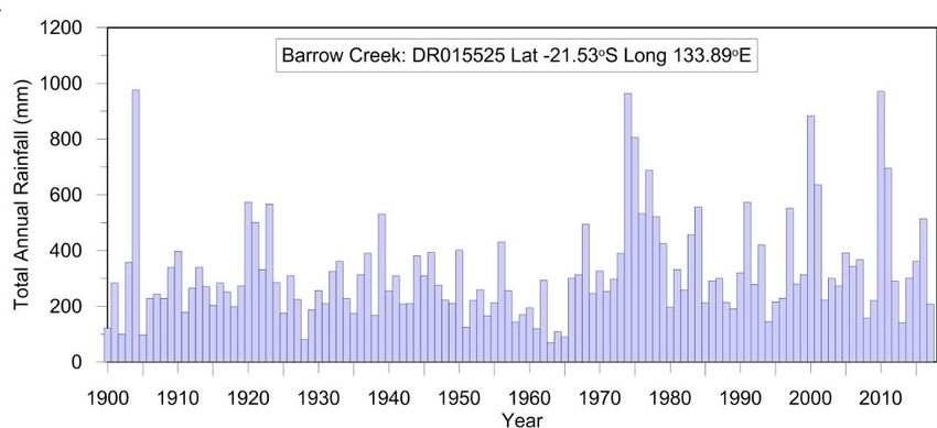
Western Davenport Water Allocation Plan 2018 – 2021

8    Water management arrangements ........................................................................................................... 39
     8.1    Allocation of water to beneficial uses under the WAP ......................................................... 39
            8.1.1    Environmental water allocations ............................................................................... 39
            8.1.2    Cultural water allocations ........................................................................................... 39
            8.1.3    Consumptive use allocations ...................................................................................... 40
            8.1.4    Allocation of the consumptive pool to beneficial uses ......................................... 40
     8.2    Protection of environmental and cultural values ................................................................... 42
            8.2.1    Terrestrial vegetation groundwater dependent ecosystems ............................... 42
            8.2.2    Aboriginal cultural values ............................................................................................ 43
            8.2.3    Monitoring triggers ....................................................................................................... 44
     8.3    Licensing and other relevant regulation and policy ............................................................... 46
            8.3.1    Groundwater licences .................................................................................................. 46
            8.3.2    Surface water licences ................................................................................................. 46
            8.3.3    Licence conditions ........................................................................................................ 46
            8.3.4    Unused water ................................................................................................................ 47
            8.3.5    Water trading................................................................................................................. 47
            8.3.6    Licensed use from SWR allocations .......................................................................... 48
            8.3.7    Other relevant polices ................................................................................................. 48
     8.4    Reporting obligations ................................................................................................................... 48
            8.4.1    WAP implementation activities.................................................................................. 49
9    Risk identification and mitigation strategies........................................................................................... 54
     9.1      Risk assignment ............................................................................................................................. 54
10   WAP implementation, monitoring and review ....................................................................................... 60
     10.1   Adaptive management framework ............................................................................................ 60
     10.2   Implementation ............................................................................................................................. 65
            10.2.1 Monitoring implementation of the WAP ................................................................. 65
     10.3   Evaluation of WAP implementation .......................................................................................... 65
            10.3.1 Evaluation of WAP impact and appropriateness .................................................... 65
            10.3.2 Evaluation of WAP effectiveness .............................................................................. 66
           10.3.3 Evaluation of outputs ................................................................................................... 66
     10.4  Reviewing the WAP ..................................................................................................................... 66
Schedule 1:        Stakeholder engagement and consultation ............................................................................ 67
Schedule 2:        Western Davenport WCD Regional Aquifer Cross Section................................................ 68
Schedule 3:        Strategic Aboriginal Water Reserve Eligible Rights Holders .............................................. 69
Schedule 4:        Eligible Land for Strategic Aboriginal Water Reserve .......................................................... 71
Schedule 5:        Risk definition and classification ............................................................................................... 72
Appendix 1:        Gazettal of the Western Davenport Water Control District .............................................. 73
Appendix 2:        Gazettal of Beneficial Uses: Western Davenport Water Control District ....................... 74
Appendix 3.        Gazettal of the Western Davenport Water Allocation Plan ............................................... 75

Page 4 of 80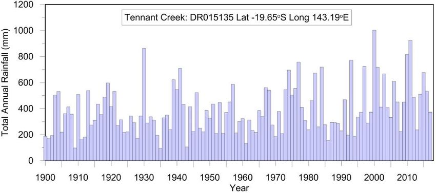
Western Davenport Water Allocation Plan 2018 – 2021

List of tables
Table 1.     Estimated Sustainable Yield (ESY) and Consumptive Pool – waterways (ML/year) .............. 7
Table 2.     ESY and consumptive pool – groundwater (ML/year)................................................................. 9
Table 3.     Management zones - hydrogeological attributes ....................................................................... 21
Table 4.     Natural water balance - predicted after 100 years (without extraction) ............................... 23
Table 5.     Natural water balance (ML/year) ................................................................................................... 24
Table 6.     Licensed entitlements and actual use for 2016-17 (ML/year)................................................. 30
Table 7.     Current unlicensed groundwater use ............................................................................................ 31
Table 8.     Projected future consumptive water requirements – including current licensed use and
             applications (ML/year)...................................................................................................................... 32
Table 9.     Estimated sustainable yield – waterways (ML/year) ................................................................. 33
Table 10.    Estimated sustainable yield – groundwater (ML/year) .............................................................. 34
Table 11.    Allocation of the Estimated Sustainable Yield to environment and cultural beneficial uses
             (ML/year) ............................................................................................................................................ 39
Table 12.    Estimated Sustainable Yield - Consumptive Pool (ML/year) .................................................... 40
Table 13.    Allocations to consumptive beneficial uses – Groundwater (ML/year) ................................. 41
Table 14.    Percentage of the consumptive pool allocated to SWR in each management zone ........... 42
Table 15.    Risk management treatments ......................................................................................................... 55
Table 16.    Responses to adaptive management triggers.............................................................................. 62

List of figures
Figure 1.    Western Davenport Water Control District boundary and land tenure................................ 12
Figure 2.    Aboriginal Land in the Western Davenport Water Control District ....................................... 13
Figure 3.    WAP development process............................................................................................................. 15
Figure 4.    Total annual rainfall at Barrow Creek and Tennant Creek 1900-2010 ................................. 17
Figure 5.    Surface Water, sub-catchments and flow directions in the WDWCD .................................. 19
Figure 6.    Management Zones in the WDWCD ............................................................................................ 20
Figure 7.    Conceptual Model from Knapton (2017) (modified from DHI (2016)) .................................. 22
Figure 8.    Depth to groundwater in the WDWCD ....................................................................................... 26
Figure 9.    Total annual water use compared with licensed amounts........................................................ 30
Figure 10.   Rainfall and recharge projections (based on past 100-year rainfall data) .............................. 35
Figure 11.   Groundwater Dependent Ecosystem Protection Area.............................................................. 45
Figure 12.   Adaptive management framework ................................................................................................ 61

                                                                                                                                               Page 5 of 80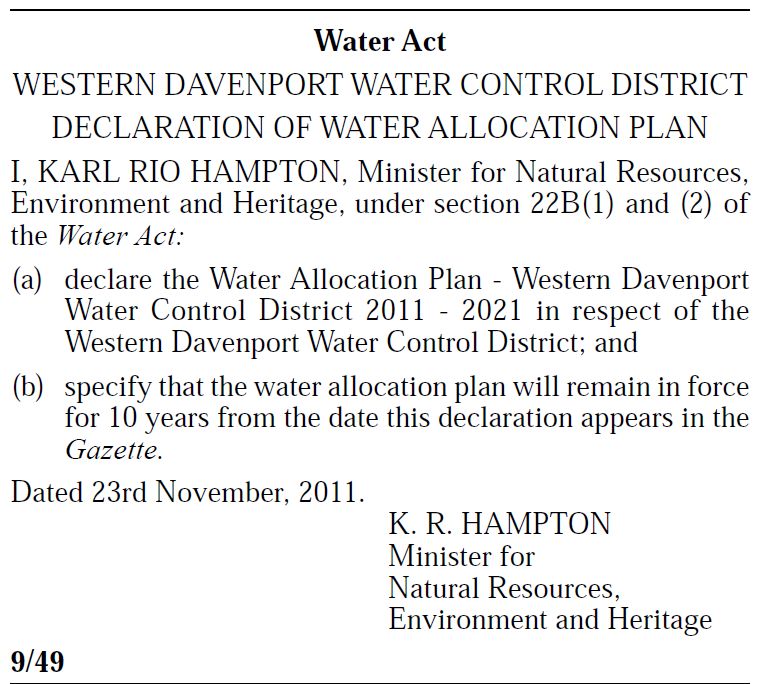
Western Davenport Water Allocation Plan 2018 – 2021

1       Summary
The Northern Territory Government has committed to the long term sustainable management of the
Territory’s water resources through its 2016 Sustainable Water Use Policy (NT Government 2016).
Consistent with this goal, this Western Davenport Water Allocation Plan 2018-2021 (WDWAP) has
been declared under section 22B(1) of the Water Act (the Act). It replaces the WAP which was declared
in 2011.

The WDWAP applies to the Western Davenport Water Control District (the District), which covers an
area of almost 24,500 square kilometres located approximately 150 kilometres south of Tennant Creek.
Its purpose is to ensure that water resources are managed in a way that protects and maintains
environmental and cultural values while allowing water to be sustainably used for productive
consumptive beneficial uses.

The objectives of the WDWAP are to:
1.   Meet the environmental water requirements of water dependent ecosystems.
2.   Protect Aboriginal cultural values associated with water and provide access to water resources to
     support local Aboriginal economic development.
3.   Allocate water for future public water supply and rural stock and domestic purposes.
4.   Provide equitable access to water to support ecologically sustainable regional economic
     development.

Development of the WDWAP commenced in 2016 and included formal public consultation on a draft
in May and June 2017. It incorporates the advice of the Western Davenport Water Advisory Committee
(WDWAC). Land owners, including Traditional Owners, pastoral lessees and business owners have been
consulted during the development of this WAP. The identification of areas of cultural significance has
been informed by consultation with Traditional Owners and assisted by the Central Land Council (CLC).

The WDWAP allocates surface and groundwater resources within the District.

Three management zones have been recognised. These are hydrogeologically distinct environments
occurring within the WDWAP area. These are the Davenport Ranges, the Southern Ranges and the
Central Plains (Figure 1). The major groundwater resource occurs within the Central Plains Management
Zone.

Surface water resources are ephemeral and limited throughout.

The WAP is based upon a substantially improved scientific basis to the previous WAP. Key
improvements are:
•    a new groundwater model (Knapton 2017)
•    additional hydrogeological information based upon the results of drilling, remote sensing data,
     groundwater monitoring programs and information from production bores
•    consultation with the Traditional Owners which has highlighted the importance and some of the
     conservation requirements for cultural values reliant on water resources
•    research and interrogation of data on the existence and requirements for protection of
     groundwater dependent ecosystems (GDEs).

Page 6 of 80
Western Davenport Water Allocation Plan 2018 – 2021
1.1 Estimated Sustainable Yield (ESY)
This WDWAP adopts the following water resource allocation strategy for the Estimated Sustainable
Yield (also referred to as ESY).
1.1.1 Surface water resources
The Estimated Sustainable Yield for waterways is 224,310 ML/year. This was based on the total
catchment run-off in the District which is calculated from the modelled overland flow from 1916 to
2016 in each management zone. Table 1 sets out the Estimated Sustainable Yield for the WCD and the
three management zones. Ninety-five per cent of the Estimated Sustainable Yield is allocated to the
beneficial uses of environment and cultural.
The only declared consumptive beneficial use for waterways is rural stock and domestic use. The
consumptive use allocation of waterways is 5% of the Estimated Sustainable Yield for any surface water
flow for this beneficial use. As surface water resources support significant environmental and cultural
beneficial uses, the WDWAP recommends against any licensed waterways extraction.
Table 1. Estimated Sustainable Yield (ESY) and Consumptive Pool – waterways (ML/year)
Davenport Central Southern
Total
Ranges Plains Ranges
Estimated Sustainable
66,300 59,710 98,300 224,310
Yield
Environmental and
non-consumptive 62,985 56,725 93,385 213,095
Cultural uses
Consumptive uses (see
3,315 2,985 4,915 11,215
below)
Consumptive Pool 3,315 2,985 4,915 11,215
Public water supply 0 0 0 0
Rural stock and domestic
(not required to be 3,315 2,985 4,915 11,215
licensed)
Other licensed beneficial
0 0 0 0
uses
1.1.2 Groundwater resources
The Estimated Sustainable Yield for groundwater is 168,405 ML/year. This is based upon allocation of
100% of modelled inflows and storage increases, regolith resources and saturated zone
evapotranspiration.
30,000 ML/year is allocated to the beneficial uses of environment and non-consumptive cultural. This
equates to modelled evapotranspiration under natural conditions without extraction.
Other beneficial uses are allocated a consumptive pool from the balance of the ESY equal to
138,405 ML/year. It is noted that an increase in groundwater extraction will inevitably cause a
reduction in aquifer storage. It is recommended that accessing the consumptive pool for beneficial uses
should not result in the depletion of aquifer storage by more than 3.9% over the next 100 years.
Page 7 of 80Western Davenport Water Allocation Plan 2018 – 2021 Groundwater allocations to the beneficial uses of environment and non-consumptive cultural are intended to protect GDEs and cultural values relying on groundwater. In addition to this allocation, the WDWAP recommends the following limits to change in groundwater conditions at GDEs caused by proposals to extract groundwater: • The maximum depth to groundwater does not exceed 15 metres. • The magnitude of change in the depth to groundwater is not more than 50%. • The rate of change of the groundwater table is not more than 0.2 metres per year. The strategy to protect GDEs also includes a program to improve the information base upon which GDEs are managed. This includes field assessment and mapping of GDEs, research into GDE groundwater access requirements and a program of monitoring GDE condition and groundwater levels at GDE sites. Cultural values in the District which depend upon access to water resources are recognised for protection. Cultural values coincident with GDEs are generally protected using the same limits of change as for GDEs. However, cultural values will often have other protection requirements or occur in different places. The WDWAP seeks to protect cultural values by building the understanding of the location and water access requirements of cultural values depending on water. The WDWAP also recommends the involvement of Traditional Owners to advise on cultural values and their groundwater requirements via formation of a Traditional Owner advisory committee (or a different approach to achieve the same effect) and working with the Rangers in assessing, monitoring and preserving cultural values. Target levels are established for both groundwater levels and resource condition for GDEs and cultural values. These levels will establish triggers at which adaptive management responses should be enacted. These will be tracked via a program of monitoring of resource condition and groundwater levels which will be reported annually. As noted, the allocation to consumptive beneficial uses is 138,405 ML/year. The allocations in each management zone and beneficial use are shown in Table 2. Page 8 of 80
Western Davenport Water Allocation Plan 2018 – 2021

Table 2. ESY and consumptive pool – groundwater (ML/year)

                                       Davenport         Central        Southern
                                                                                         Total
                                        Ranges           Plains          Ranges
 Estimated sustainable yield               15,065         112,720         40,620       168,405
  Environmental and cultural uses           4,000          25,000          1,000         30,000
  Consumptive uses                         11,065          87,720         39,620       138,405
 Consumptive pool                          11,065          87,720         39,620       138,405
  Public water supply                            0            500             60            560
  Rural stock & domestic
                                               90             250            150            490
  (unlicensed)
 Other licensed beneficial uses            10,975          86,970         39,410       137,355
  General pool (agriculture,
  industry, aquaculture, cultural           7,682          60,879         35,469       104,030
  beneficial uses)
  Strategic Aboriginal Water
  Reserve (sub-classes agriculture,
                                            3,293          26,091          3,941         33,325
  industry, aquaculture, cultural
  beneficial uses)

Any licensed use of water should include conditions to safeguard GDEs, monitoring commitments and
contingency commitments. Approvals for large groundwater entitlements greater than 2,000 ML/year
are recommended to be subject to staged increases in groundwater entitlements. This will reduce the
likelihood of undesirable impacts on the aquifer, environmental and cultural values and other users.
Increases in entitlements should be staged and performance-based depending upon the achievement
of satisfactory performance and environmental monitoring results and achievement of development
targets. These staged allocations can be reserved in the consumptive pool for the period of the licence
term, for release when the licence conditions applying to licence stages are met or for return if
conditions and progression to the next development stage are not met.

The WDWAP reinforces the management of unused water entitlements and principles for trading water
entitlements. It recognises that location, market forces and weather all play a role in water use and
recommends a threshold of 70% of the allocation for three consecutive years as the trigger for
identifying unused water.

Modelling has highlighted that the ability to maximise the consumptive pool is contingent upon bore
field locations and pumping strategies. The consumptive pool allocation in the Central Plains
Management Zone assumes groundwater extraction is distributed across the management zone. The
current focus for groundwater development is tightly concentrated upon the area near to the Stuart
Highway between the Ali Curung turnoff and Wycliffe Well. This coincides with relatively shallow
groundwater and nearby GDEs. The onus will be upon proponents, through extraction volumes and
design and management of proposed bore fields to demonstrate that groundwater extraction proposals
can occur within the assessment criteria established in the WAP to protect GDEs and cultural values.
The cumulative impact of groundwater extraction proposals should be modelled by the Department of
Environment and Natural Resources in providing assessment advice to the Controller of Water
Resources in terms of applications for groundwater extraction licences.

                                                                                          Page 9 of 80
Western Davenport Water Allocation Plan 2018 – 2021 The WAP adopts an adaptive management framework. This includes establishing trigger values for groundwater levels and condition of GDEs and cultural values at which various management responses should be enacted. It is noted that the WAP is based on limited information. Further research, particularly in regard to accessibility of groundwater stored in the regolith and the location and individual requirements of GDEs is recommended to occur within the term of the WAP. Due to these data limitations, there is a significant risk that the consumptive pool could be reduced in future WAPs. Page 10 of 80
Western Davenport Water Allocation Plan 2018 – 2021

2        Introduction
2.1      Western Davenport Water Allocation Plan
This WAP is the Western Davenport Water Allocation Plan 2018-2021 (WDWAP).

2.2      The Western Davenport WAP area
         2.2.1    WAP area
The WDWAP applies to the Western Davenport Water Control District (the District), as declared on
15 July 2009 under section 22 of the Water Act (Appendix 1). The location of the District and its
principal land tenures are shown in Figure 1.

The District covers an area of almost 24,500 km2 located approximately 150 km south of Tennant
Creek in the Northern Territory (NT).

         2.2.2    Description
While the District has predominantly flat terrain, the north-east boundary straddles the Davenport
Ranges and the southern boundary includes the Forster and Spring Ranges. Between these ranges the
area mainly consists of: lightly wooded red aeolian sand plain (sand transported and deposited by wind)
covered with spinifex, or by dense mulga shrubland, with intermittent low sand dunes; large patches of
alluvial flood out country; ephemeral swamps and clay pans; and some small areas of colluvial foot
slopes adjacent to the ranges.

The vast majority of water places in the District are of cultural significance. These include rock-holes,
rivers, and riverine flood outs, springs and soaks. Large trees on flood outs are often culturally significant
and may use groundwater. The Hanson River, along the western border, has considerable cultural
importance. Part of the District is also within the ‘Davenport and Murchison Ranges’ Site of
Conservation Significance.

         2.2.3    Population and land uses
Approximately 1,000 people live in the District, including around 500 people in the major community
of Ali Curung. The District also includes three smaller communities (Imangara, Mungkarta and Tara) and
nine homelands/family outstations (Ankweleyelengkwe, Annerre, Greenwood, Illeuwurru, Imperrenth,
Indaringinya, Kalinjarri, Tjuperle and Wakurlpu).

The District is centred on Kaytetye country and also incorporates Alyawarr country in the southwest,
Warramungu country to the far north and Warlpiri country to the far west. People from all these groups
reside at Ali Curung. Approximately 41% of the District is recognised as Aboriginal Land (refer Map 2).

The pastoral industry has a long history in the District and is a major land user. Five pastoral leases
overlap the District (Stirling, Murray Downs, Elkedra, Neutral Junction and Singleton stations). The
District also supports a number of tourism enterprises as well as an established horticultural industry.
There is strong interest in increasing horticultural development in the District and some mining
exploration is occurring in the general area.

2.3      Term of the WAP
This WDWAP has been developed as required under section 22B(3) of the Water Act based on a review
of the Plan previously in place. The WAP will remain in force until 6 December 2021. Any amendment
or variation of the WDWAP will come into effect by publication of the relevant a notice in the Gazette.

                                                                                              Page 11 of 80
Western Davenport Water Allocation Plan 2018 – 2021 Figure 1. Western Davenport Water Control District boundary and land tenure Page 12 of 80
Western Davenport Water Allocation Plan 2018 – 2021

Figure 2.   Aboriginal Land in the Western Davenport Water Control District

                                                                                 Page 13 of 80
Western Davenport Water Allocation Plan 2018 – 2021 2.4 Context Under section 22B of the Water Act (the Act), the Minister may declare a WAP for a period of up to ten years. Section 22B also requires reviews to be conducted at no longer than 5-yearly intervals. WAPs take their legal force from the Act, which remains the main source of legal rights and obligations affecting the use of water resources in the Northern Territory. While this WDWAP contains summaries of the effect of certain provisions of the Act, those summaries are provided for information only. The WAP should be read in conjunction with the Act, and will be subject to any amendments which may be made to the Act after the declaration date of the WAP. WAPs establish a framework to share water between consumptive and non-consumptive uses. Water resource use in a water control district is to be in accordance with such a WAP. This ensures that water is allocated within the Estimated Sustainable Yield to beneficial uses, as defined in section 4(3) of the Water Act. The current Western Davenport Water Control District was declared on 15 July 2009 (Appendix 1). The beneficial uses of water and water quality objectives in the District were declared on 16 March 2016 (Appendix 2). The previous WDWAP was declared on 7 December 2011 (Appendix 3) and this WDWAP has reviewed that Plan; the review formally commenced in 2016. The review identified the need to ensure that the WDWAP aligns with the NT Water Allocation Planning Framework (NT Government 2018a) (a policy of the NT Government). As a consequence, this WDWAP makes allocations to support groundwater dependent ecosystems ahead of allocations to consumptive uses. This WDWAP is considered to be consistent with the NT Water Allocation Planning Framework. This WDWAP allocates the water resources in the District to beneficial uses and recommends principles for water resource management in the District until 6 December 2021. The review process has involved input from a stakeholder representative Western Davenport Water Advisory Committee (WDWAC), Traditional Owners, community and industry stakeholders and relevant NTG departments. The WDWAP is based on a new groundwater model (Knapton 2017) and adopts new groundwater management area boundaries. The new groundwater model water enables a better understanding of the groundwater systems in terms of their recharge, storage and discharge characteristics. The WDWAP outlines a new approach and decision criteria to assess the potential impact of groundwater extraction on areas of cultural values and on groundwater dependent ecosystems (GDEs). The process to develop the WAP included consultation on a draft WAP released in July 2017. A report on community engagement (NT Government 2018b) outlines the submissions received and how these have been addressed in the WDWAP. There is considerable interest in agricultural and horticultural development in the District and significant mineral exploration is occurring. These have the potential to contribute significantly to the regional economy. The WAP is intended to ensure the fair and equitable sharing of water resources of the District and the sustainable management of the resource for the future. Page 14 of 80
Western Davenport Water Allocation Plan 2018 – 2021

2.5      WAP development process
WAPs are developed through technical and scientific assessments and community consultation to
determine an appropriate balance between competing requirements for water. The steps in Figure 3
are undertaken in developing or reviewing a WAP.

         Water Control                  Water planning area defined                Resource assessment
        District Declared                                                              undertaken

                                  Consult with community over issues and
                              composition of Water Advisory Committee (WAC)
        Beneficial Uses
          Gazetted
                                          Minister establishes WAC
                12-18
                Months
                                    WAC knowledge and skills enhanced
                                                                                    Consultation with
                                                                                         WAC
                                           Draft WAP developed

                                                                                    Engagement with
                                                                                      stakeholders
                             Minister releases draft WAP for public consultation

                              Consideration of submissions by DENR and WAC

                 6-9
                Months
                                       Amend draft WAP as required

                                          Minister declares WAP

                                     WAP implemented and reviewed

Figure 3.   WAP development process

Schedule 1 outlines the stakeholder engagement and community consultation that has occurred as part
of the development of the WAP. A report on community engagement (NT Government 2018b) has
been prepared documenting the process and the input received from community engagement activities.

The WDWAC was established in 2017 to provide advice and recommendations to the Controller of
Water Resources and the Department of Environment and Natural Resources to help finalise the
revised WDWAP. The WDWAC has contributed to the relevant steps in Figure 3 since the draft WAP
was released.

                                                                                          Page 15 of 80
Western Davenport Water Allocation Plan 2018 – 2021
3 Purpose and Objectives
The purpose of a water allocation plan as defined in section 22B of the Water Act is to ensure that in a
water control district:
• 22B(5)(a): water is allocated to beneficial uses within the Estimated Sustainable Yield;
• 22B(5)(b): the total water use for all beneficial uses (including those through rural stock and
domestic use and licences) is less than the sum of the allocations to each beneficial use.
The objectives of this WDWAP are to:
1. Meet the environmental water requirements of water dependent ecosystems
Detrimental impacts to water dependent ecosystems as a consequence of consumptive water use
will be avoided as far as possible.
2. Protect Aboriginal cultural values associated with water and provide access to water resources
to support local Aboriginal economic development.
Maintain and support traditional cultural values through the protection of cultural values
dependent on water, as well as providing access to water for commercial development in
accordance with the Strategic Aboriginal Water Reserve Policy Framework.
3. Allocate water for future public water supply and rural stock and domestic purposes
To ensure a safe water supply, sufficient in volume and quality for essential services to
communities as well as for rural stock and domestic water requirements.
4. Provide equitable access to water to support ecologically sustainable regional economic
development
Development of sustainable water consumptive industries supporting regional economic
development that benefits current and future generations and is conducted within an
environmentally sustainable framework.
As part of the development of this WDWAP, knowledge gaps were identified and a risk assessment
undertaken of those gaps. This risk assessment has informed the approach to the performance
evaluation and the development of actions which the Government commits to undertake to fill
identified knowledge gaps.
In this context, the achievement of the WAP’s objectives will be supported by an adaptive management
approach. Integrated annual report of monitoring and compliance will report system performance
against key performance indicators and adaptive management triggers. As new scientific knowledge
about the water resources and water dependent ecosystems is obtained or the Department of
Environment and Natural Resources becomes aware of requirements for protection of cultural values,
this knowledge will be used in providing advice to the Controller. New information can be incorporated
into a new WDWAP at the time of review or in certain circumstances an immediate review of the
WDWAP could be triggered by the Minister.
Page 16 of 80Western Davenport Water Allocation Plan 2018 – 2021
4 Water resources (supply and condition)
4.1 Climate and rainfall
The District has an arid climate with highly variable and episodic rainfall. It is hot in the summer months
between October and March, and relatively mild and dry for the remainder of the year. The average
monthly maximum temperature is approximately 38°C in the summer (October and March) and 24°C
in the winter (April to September) months.
Rainfall over the District is predominantly derived from thunderstorms falling between November and
March, and is largely influenced by the dissipation of tropical rainfall depressions and monsoonal
activity. The average rainfall of the District, based on more than 120 years of records, varies from
322 mm per year at Barrow Creek to 392 mm per year at Tennant Creek to the north of the District.
Source: SILO (https://www.longpaddock.qld.gov.au/silo/about.html)
Figure 4. Total annual rainfall at Barrow Creek and Tennant Creek 1900-2010
Page 17 of 80Western Davenport Water Allocation Plan 2018 – 2021
There is significant variability in annual rainfall. For example, at Barrow Creek the highest annual rainfall
was 975 mm in 1904 and the lowest was 70 mm in 1963. Similarly, in Tennant Creek the highest annual
rainfall was 1003 mm in 2000 while the lowest annual rainfall recorded was 95mm in 1935 (refer to
Figure 4).
4.2 Surface water resources
Surface water in the District is ephemeral and is not a reliable source of water for consumptive uses.
The District includes a surface water catchment of nearly 15,000 km², and is mostly within the Wiso
Surface Water Management Area – also referred to the ‘Wiso Drainage Basin’.
The District includes:
• Two major ephemeral rivers (Hanson River and Taylor Creek) which flow north, into or towards
the Tanami Desert.
• Ephemeral rivers and creeks such as Wycliffe Creek which flow off the Davenport Ranges in a
south-westerly direction and join to flow along a north-west flood path, which continues beyond
the Western Davenport Plains for a further 200 km.
• Significant ephemeral swamps, claypans, and floodouts, including Thring Swamp (a floodout of
Wycliffe Creek), Warrabri Swamp and Skinner Creek floodout, and the Bonney Creek, McLaren
Creek and Gilbert Creek floodouts.
The wetlands of the District are associated with, and include, the rivers and creeks which emanate from
rocky ranges. The deeper waterholes in major channels hold water the longest in the District, although
few, if any, are permanent. Most of the larger wetlands are associated with the river floodouts where
water spreads out from a defined channel. These wetlands can be filled from rain that has fallen many
kilometres away and travelled down the river channels before flooding out. They can also be filled from
more localised rainfall and flooding events (Duguid 2009). These may be more prominent in shallow
groundwater areas.
4.3 Groundwater resources
There are three hydrogeologically distinct environments occurring within the District. These
correspond with the Davenport Ranges, the Southern Ranges and the Central Plains Management
Zones (Figure 1). The higher yielding and better quality aquifers occur in the Central Plains with poorer
quality and unreliable groundwater occurrence elsewhere. A regional aquifer cross section is at
Schedule 2. Details about each of the management zones are summarised in Table 3.
The most significant groundwater resources are the Lake Surprise Sandstone, Arrinthunga Formation,
Chabalowie Formation, and Dulcie Sandstone aquifers underlying the Central Plains Management Zone.
Water stored in these aquifers is very old, having been in long-term storage for thousands of years.
The Central Plains Management Zone has the largest volume and best quality of water within the
District. Recent modelling indicates there is a high degree of connectivity between the aquifers within
this zone. As a result extraction from one resource is expected to impact the neighbouring aquifers. As
noted, water resources in the Southern Ranges and Davenport Ranges Management Zones are limited.
Consequently, the water resources in these management zones are expected to be primarily used for
stock purposes.
Page 18 of 80Western Davenport Water Allocation Plan 2018 – 2021
Figure 5. Surface Water, sub-catchments and flow directions in the WDWCD
Page 19 of 80Western Davenport Water Allocation Plan 2018 – 2021 Figure 6. Management Zones in the WDWCD Page 20 of 80
Western Davenport Water Allocation Plan 2018 – 2021

Table 3. Management zones - hydrogeological attributes

                                     Davenport Ranges            Central Plains          Southern Ranges

                                                                  Arrinthunga
                                                             Formation Chabalowie
  Aquifer rock types                Proterozoic Sandstone       Formation Lake         Proterozoic Sandstone
                                                              Surprise Sandstone
                                                               Dulcie Sandstone
                                         Davenport               Wiso (north)           Arunta Block (north)
  Underlying basin(s)
                                         Geosyncline            Georgina (south)         Georgina (south)
  Salinity (TDS ) (water
                                        Highly variable           600 - >3000              Highly variable
  quality)
  Potential bore yields
Western Davenport Water Allocation Plan 2018 – 2021
The groundwater model provides water balance estimates for the main aquifers and assists in
identifying the water resources potentially available for allocation. The model can be used to inform the
positioning of new bores and bore fields by predicting the effects of different extraction volumes on
aquifer levels by modelling different water use scenarios and different bore configurations.
The groundwater model also has the capacity to accommodate the potential effects to estimated
recharge under various climate change scenarios. For a detailed description of the groundwater model,
refer to Knapton (2017). Figure 7 shows the conceptual model from Knapton (2017).
Figure 7. Conceptual Model from Knapton (2017) (modified from DHI (2016))
4.4.1 Natural water balance
The natural water balance (Table 4) is based on modelling using the past 100 years of climate data.
Estimates beyond 100 years have not been undertaken due to the difficulty in predicting future climate
beyond the next 100 years. Modelling scenarios for the next 100 years (projecting to 2116) are based
on application of the climate record for 1916 to 2016.
The natural water balances for the groundwater resources in each of the three water management
zones includes the volumes of water in storage, combined with the inputs (recharge, inflow) and outputs
(discharge, outflow and evapotranspiration).
Page 22 of 80Western Davenport Water Allocation Plan 2018 – 2021
Table 4. Natural water balance - predicted after 100 years (without extraction)
Management Zones Davenport Ranges Central Plains Southern Ranges
Starting Total Aquifer Storage
503,117 138,314,200 702,280
(ML)
Average Annual Aquifer Inflow
10,430 45,190 32,570
(ML/year)
Average Annual Aquifer Outflow
10,066 57,082 29,206
(ML/year)
Final Total Aquifer Storage(ML) 529,502 137,129,400 765,300
Change in Aquifer Storage after
100 years (ML) and 26,385 1,184,800 63,020
percentage change 5.2% increase 0.85% decrease 9% increase
4.4.2 Modelled groundwater availability
The water balance by Knapton (2017) was used to infer yields available from the aquifer. Estimates for
each management zone are shown in Table 5. Pre-extraction modelled saturated zone
evapotranspiration is considered to reflect the ongoing environmental requirement. Recharge is the
portion of rainfall that passes through the unsaturated zone into the saturated zone, less the
evapotranspiration loss. This is the volume of water that enters the groundwater system. As noted the
recharge periods are rare and therefore difficult to predict; thus adoption of the longest available rainfall
record is considered to provide the most reliable means of avoiding any shorter-term rainfall anomalies.
The long-term recharge entering the basin aquifers within each management zone was modelled using
Bureau of Meteorology climate data from 1916-2016.
An additional groundwater resource exists in the shallow saturated regolith, the unconsolidated,
weathered soil and gravel material overlying the aquifers. The regolith is saturated when the underlying
aquifer is saturated and cannot accept any more recharge. As groundwater levels in the regolith are
relatively steady, the shallow resource is considered to be in steady state with evapotranspiration and
seepage losses being balanced by ongoing annual replenishment.
The volume of water stored in the regolith above 15 metres below ground level is shown in Table 5.
Based on depletion of this volume over 100 years, the volume shown in Table 5 would be available with
the expectation of occasional replenishment.
Further work is needed to define the regolith resource and ecosystem access requirements.
Page 23 of 80Western Davenport Water Allocation Plan 2018 – 2021
Table 5. Natural water balance (ML/year)
Natural Modelled Regolith yield Regolith yield +
Evapotranspiration Recharge (0 – 15m storage Modelled
WDWAP depleted over Recharge
Management zone 100 years)
Davenport Ranges 4,000 11,000 65 11,065
Central Plains 25,000 57,000 30,720 87,720
Southern Ranges 1,000 36,000 3,620 39,620
TOTAL 30,000 104,000 34,405 138,405
Page 24 of 80Western Davenport Water Allocation Plan 2018 – 2021
5 Water use
5.1 Water use overview
The following are the beneficial uses of water under section 4(3) of the Water Act:
a) agriculture – to provide irrigation water for primary production including related research
b) aquaculture – to provide water for commercial production of aquatic animals including related
research
c) public water supply – to provide source water for drinking purposes delivered through community
water supply systems
d) environment – to provide water to maintain the health of aquatic ecosystems
e) cultural – to provide water to meet aesthetic, recreational and cultural needs
f) industry – to provide water for industry, including secondary industry and a mining or petroleum
activity, and for other industry uses not referred to elsewhere in this subsection
g) rural stock and domestic – to provide water for the purposes permitted under sections 10, 11
and 14.
The beneficial uses declared for the WDWCD (Appendix 2) are as follows.
• For waterways: environment, cultural and rural stock and domestic
• For groundwater: environment, cultural, agriculture, aquaculture, public water supply, industry
and rural stock and domestic.
5.2 Non-consumptive use
5.2.1 Environmental water use
Environmental values
Environmental water uses concern the water needs of natural ecosystems. As the only licensed
consumptive beneficial uses in the District are for groundwater extraction, the focus is upon
consideration of the ecosystem requirements for groundwater.
GDEs were defined by Kuginis et al. (2016, p. 2) as ecosystems requiring: “access to groundwater to meet
all or some of their water requirements so as to maintain their communities of plants and animals, ecological
processes and ecosystems services”. The NT Water Allocation Planning Framework specifies that GDEs
must be protected from deleterious impacts when considering water extraction licence applications in
the arid zone.
Cook and Eamus (2018a) reported evidence of significant groundwater use in areas with water tables
from 8-12 metres and some evidence of groundwater use at depths of 15-20 metres. The bloodwood
(Corymbia opaca) was found to be capable of accessing groundwater to 15 metres. Species found
accessing groundwater at shallower depths (Western Davenport Water Allocation Plan 2018 – 2021 Figure 8. Depth to groundwater in the WDWCD Page 26 of 80
Western Davenport Water Allocation Plan 2018 – 2021

Stygofauna (small aquatic invertebrate animals) have been found in groundwater in some parts of
central Australia. Aquifers containing stygofauna are also considered GDEs. The WDWAP covers the
Wiso Basin, which is identified as having high potential for stygofauna (Moulds and Bannink 2012).
Stygofauna are likely to be present in alluvial, karstic and some fractured rock aquifers at depths of less
than 100 metres (Hose, Sreekanth, Barron and Pollino 2015).

A small number of springs are known in the District, as well as waterholes sustained by groundwater
discharge. These are not well documented but are thought to mainly occur in and near the rocky ranges.
Where associated with the ranges, is considered unlikely that GDEs of these types would be impacted
by licensed groundwater extraction.

         Considerations in the protection of GDEs

Cook and Eamus (2018b, 7-8) found that GDEs can be impacted when:

•     the water table falls below the maximum rooting depth
•     the rate of water table decline exceeds the rate of root growth
or
•     the magnitude of water table decline is excessive.

The authors suggested a cut-off of 15 metres below ground surface, as the maximum water table depth
that can be assessed by vegetation (rooting depth), is reasonable and should be applied.

With respect to the rate of drawdown, information on these requirements is inferred from studies
conducted elsewhere. The best available information (from banksias in Western Australia) suggested
that woody plants can follow declining water tables at a rate of decline of 20 cm per year. Cook and
Eamus (2018b) suggested that this is reasonable in the absence of better information.

The above rate of decline is not without limits. In relation to the maximum magnitude of water table
decline (over baseline), a relative change of no more than a 50% increase in depth to groundwater below
a predetermined baseline and not beyond 15 metres below ground surface, is recommended as an
appropriate initial safeguard.

Protection of GDEs also needs to be underpinned and supported by research, monitoring and regulatory
processes. Information needs include: detailed mapping of GDEs including identification of priority
conservation areas and types; research into GDE groundwater use and vulnerabilities to change; and,
mapping of depth to groundwater contours in the areas where the depth to groundwater is less to
20 metres (Figure 8).

Monitoring requirements include monitoring changes in the groundwater table and ecosystem health.
These are necessary in order to improve the understanding of GDE access requirements to groundwater
and to identify any risks to or actual deleterious impacts on GDEs.

Regulatory processes are required in respect to managing the impacts of extraction proposals on GDEs.
Given this uncertainty, the WDWAP needs to be supported by an adaptive management framework
which provides flexibility to adjust management approaches and allocation decisions.

                                                                                            Page 27 of 80
Western Davenport Water Allocation Plan 2018 – 2021
5.2.2 Cultural water use
Cultural values
Aboriginal people within the District have a strong connection to country. The cultural landscape of this
area includes physical (e.g. sacred sites, ancestor trees and other features such as stone arrangements)
and non-physical (e.g. knowledge, practices, songs, ceremony) cultural values. All water sources such as
soaks, rock holes, springs and rivers play a major role in the social, spiritual and customary values of the
Traditional Owners of the District.
In addition to cultural values, Traditional Owners are subject to the rules and institutions associated
with customary law. It is important to recognise Traditional Owners as being central to the
interpretation of customary law as it relates to the management of cultural values. This includes
obligations for managing country, managing access to sites, and passing on knowledge and law, which
are key aspects of cultural identity. Hence the use of a water resource is not only physical and extends
to other cultural values through activities such as visiting and maintaining sites, sharing and teaching
cultural knowledge, conducting ceremony, or participating in management decisions.
Dreaming lines which run throughout this area as part of the cultural landscape often relate to surface
water ecosystems. The continuing importance of these water-related sites and their cultural
associations is emphasised by activities such as the “Walking and Sharing Stories from Bonney Creek
to Barrow Creek” in June 2008 when about 65 Kaytetye, Warramungu, Warlpiri and Alyawarra people
took 15 days to walk 140 km between some 30 soaks near the central north-south axis of the District,
with Traditional Owners working to maintain the health of the soaks along the way (Central Land
Council 2008).
The significance of water for Traditional Owners is not limited to surface water and GDEs as it is found
throughout the country and in all living things. Water availability also affects many activities, like
hunting and harvesting for bush tucker, bush medicine, tool and craft making.
Soaks are considered one of the most important sources of water in the desert. Knowledge of where
to find water, and how to source it, is vital information passed down from generation to generation.
Hunting and harvesting is regularly conducted in these environments and habitats. Significant drying or
lowering of the water table could adversely affect the availability of water in soaks and the health of
important GDEs.
The floodouts and associated vegetation are culturally important to the Traditional Owners, particularly
in relation to large trees they support (such as Eucalyptus sp. and Corymbia sp.) and the high importance
of these areas to Aboriginal cultural practices and land use. Floodouts are generally important hunting
areas and also often have ceremonial importance.
Considerations for protection of cultural uses
Decision criteria to protect cultural values are required for a range of sites, places and practices
including but not limited to family trees, soaks where animals gather and vegetation complexes relying
on access to groundwater which support cultural practices.
The approach and decision criteria outlined in section 5.2.1 would be relevant to the protection of
cultural values that coincide with GDEs. It is recognised that there are additional cultural values areas
which may not be GDEs and some cultural values which relate to GDEs but will have additional
requirements for cultural use protection such as soaks, ceremonial areas and hunting grounds. Further
work is required to ensure that these requirements are understood. Ongoing monitoring is needed to
identify any changes or threats to these values being protected.
Page 28 of 80You can also read