Rolleston on Dove Neighbourhood Development Plan 2015 - 2033 Draft Submission Version March 2019
←
→
Page content transcription
If your browser does not render page correctly, please read the page content below
Rolleston on Dove
Neighbourhood Development Plan

             2015 – 2033
    Draft Submission Version March 2019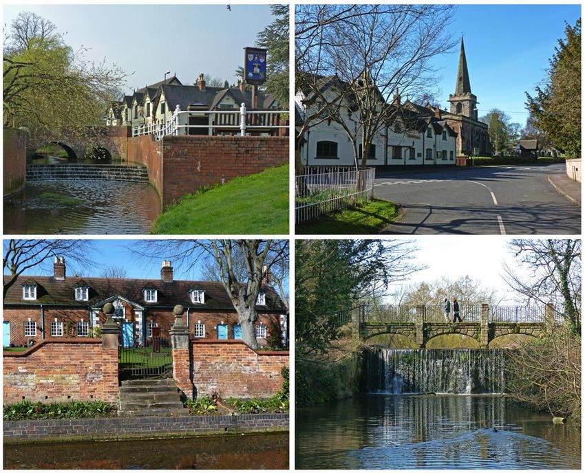
Contents
1. Introduction                                                                                                                                                    1

2. Community and Stakeholder Engagement                                                                                                                            5

3. Challenges and Opportunities facing Rolleston on Dove                                                                                                           7
 Vision ..............................................................................................................................................................7

 Aims ................................................................................................................................................................8

4. Background                                                                                                                                                     9
 About Rolleston on Dove ...............................................................................................................................9

 History ......................................................................................................................................................... 10

 The Development of Rolleston on Dove...................................................................................................... 10

     Village Population Growth ...................................................................................................................... 11

     Growth of the Village .............................................................................................................................. 11

5. Strategic Context                                                                                                                                             13
 Settlement Boundary................................................................................................................................... 14

 Transport ..................................................................................................................................................... 16

     Buses........................................................................................................................................................ 16

     Main Roads .............................................................................................................................................. 16

     Critical Traffic Points................................................................................................................................ 16

 Socio-Economic Profile ................................................................................................................................ 19

     Population ............................................................................................................................................... 18

     Housing .................................................................................................................................................... 19

     Economic Activity .................................................................................................................................... 19

     Car Ownership and Travel to Work ......................................................................................................... 20

     Health ...................................................................................................................................................... 21

6. Land Use                                                                                                                                                      22
 Predominant Land Uses ............................................................................................................................... 22

 Housing Stock .............................................................................................................................................. 22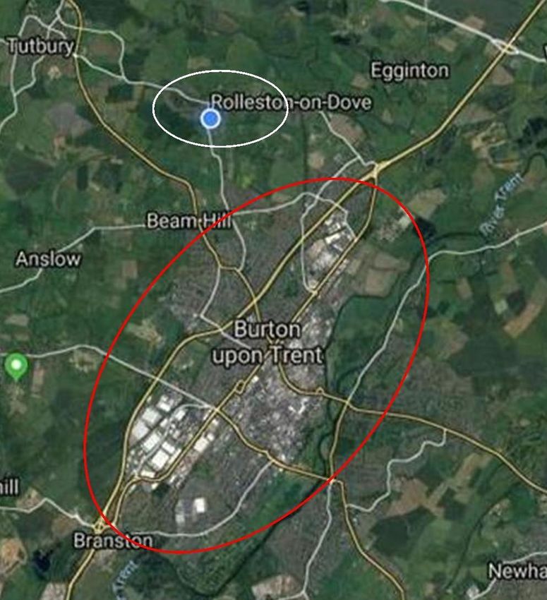
Community Facilities ................................................................................................................................... 22

  Property and Land Prices ............................................................................................................................. 22

7. Environment                                                                                                                                                 23
  Conservation Area ....................................................................................................................................... 23

  Flooding ....................................................................................................................................................... 25

  Natural Assets and Environment ................................................................................................................. 28

8. Policies                                                                                                                                                    29
  Housing Development ................................................................................................................................. 29

  Character and Design .................................................................................................................................. 32

  Natural Environment ................................................................................................................................... 43

  Community Facilities ................................................................................................................................... 47

9. Non Planning Issues                                                                                                                                         58
  Community Projects .................................................................................................................................... 58

Appendix                                                                                                                                                       60

Acknowledgements                                                                                                                                               65
1. Introduction
1.1     The Neighbourhood Development Plan covers the time period 2015 to 2033. The adopted Local
    [1]
Plan covers the period 2012 to 2031. The Neighbourhood Development Plan extends past the period of
the adopted Local Plan to provide certainty whilst a new plan is being prepared.
1.2     The Rolleston on Dove Neighbourhood Development Plan has been brought forward as part of the
Government’s Localism Act 2011, which aims to give local people more say in the future land use of the
Parish. Although the Government’s intention is for local people to influence what goes on in their
Neighbourhood Development Plan area, the Localism Act 2011, however, sets out important legal
requirements.

1.3     In accordance with such legislation, the Neighbourhood Development Plan must meet the basic
conditions:

      •   Have regard to national policies and advice contained in guidance issued by the Secretary of State,
          namely the National Planning Policy Framework and Planning Policy Guidance
      •   Contribute to the achievement of sustainable development;
      •   Be compatible with European Union (EU) and European Convention on Human Rights (ECHR)
          obligations
      •   Be in general conformity with the strategic policies of the development plan for the area

1.4     Neighbourhood Development Plans are part of the statutory planning system. This means that when
decisions are made on planning applications the policies and proposals in the Neighbourhood Development
Plan must be taken into account by the local planning authority, ESBC. All Planning applications must be
determined in accordance with the statutory development plan, unless material considerations indicate
otherwise.

1.5      Neighbourhood Development Plans are intended to be produced by local people for their own areas,
they are made through a referendum of the people living in the neighbourhood area. Unlike national planning
policy, which is approved by Parliament, or district planning policy, which is approved by the local authority,
a Neighbourhood Development Plan must be the subject of a vote by residents of the area covered by the
Neighbourhood Development Plan.

1.6     The Rolleston on Dove Neighbourhood Development Plan will be a statutory planning policy
document, which will enable the community of Rolleston on Dove and the Parish Council a greater and more
positive influence on how the area develops over the plan period 2015 to 2033.

1.7    This document sets out the aspiration for the Parish of Rolleston on Dove, ensuring that all future
development is sustainable and to help grow the rural community.

1.8       The Rolleston on Dove Neighbourhood Development Plan is important for a number of reasons:

      1.8.1       Plan positively for a level of growth ensuring that new homes should be built in the most
      sustainable and least impacting areas of the village, preserving the village character for future
      generations

                                                      1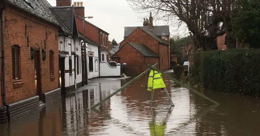
1.8.2        To maintain and preserve Rolleston on Dove as a distinct and separate village, ensuring it
   does not become a suburb of Burton upon Trent and maintain a degree of separation to the villages of
   Stretton and Tutbury, thereby keeping its important identity

   1.8.3        The protection of Local Green Space used for sport and recreation

   1.8.4        Planned growth and the scale of development to be appropriate to the size of the village, its
   infrastructure and contribute to a sustainable community

   1.8.5         Developments should meet the housing needs of the local community and be well designed
   to reflect the local character and vernacular of the village

1.9    The following matrix illustrates how the policies of the Rolleston on Dove Neighbourhood
Development Plan meet the aims that are shown in full on page 8.

                                                         1     2      3      4      5      6     7       8
                                            AIMS

 POLICY

 H1: Housing Development                   1,2,3,5       √     √

 H2: Housing Mix & Affordable Provision    1,2,3,5       √

 D1: Green infrastructure                  6,7                        √      √                    √

 D2: Design of new development             3,4,5                      √                           √

 D3: Public realm and car parking          1                          √      √

 D4: High speed connectivity               8                                        √                    √

 D5: Traffic and transport                 4                                 √

 OS1: Protection of views of local         7                          √                           √
 importance

 NE1: Flood risk                           6                                               √

 NE2: Natural environment                  7                                                      √

 OS2: Protection of Local Green Spaces     3, 7                       √             √             √

1.10 The Neighbourhood Area corresponds exactly to that within the Parish Council electoral boundary
as shown in Figure 1.

1.11     Continual plan review is a fundamental element of the planning system. It is important to check that
the plan is being implemented correctly, ensure that outcomes meet the aims and to change the plan if they

                                                     2
are not. This Neighbourhood Development Plan will be carefully monitored and reviewed by Rolleston on
Dove Parish Council

1.12 The Neighbourhood Development Plan has been prepared to guide and inform development to 2033.
There are a number of circumstances under which a partial review of the plan may be necessary, for example,
if housing need changes and/or the adopted Local Plan is reviewed, as well as looking at the impact of the
plan on planning applications. In accordance with best practice, Rolleston on Dove Parish Council and its
partners should consider undertaking a partial review of the Neighbourhood Development Plan every five
years or so from the date the plan is made.

                                                    3
Figure 1: Parish boundary covered by Rolleston on Dove Neighbourhood Development Plan

                                                                                 4
2. Community and Stakeholder Engagement
2.1     Rolleston on Dove Parish Council developed a programme of community and stakeholder engagement
and this has been used to guide the process of producing the Neighbourhood Development Plan. It
demonstrates that the Parish Council recognises that the Neighbourhood Development Plan must reflect the
needs of the community and the local area. The Rolleston on Dove Parish Council has sought to communicate
with residents in a timely and effective manner and to inform and actively engage with them throughout the
process of producing the Neighbourhood Development Plan.
2.2      The community engagement carried out on behalf of the Parish Council in producing the draft
Neighbourhood Development Plan is summarised in the community engagement table, Figure 2. To achieve
the varied community engagement, the Parish Council has used a wide range of communication methods
including special open meetings, workshops, the village notice boards, public canvassing, social media such as
the Facebook page and the parish website. Specially printed leaflets, questionnaires and a housing needs
survey were circulated to all households in the parish at the relevant key stages. Updates were also included
in the local newsletter, the Rollestonian, circulated to every household within the parish.

Figure 2: Timetable of Community Engagement

                 Date                                                Notes

 September 2011                     Newsletter to all houses advising of public meeting. Notices on
                                    noticeboards, Facebook, website.

 October 2011                       Open meeting with village; first Rolleston on Dove Neighbourhood
                                    Development Plan Steering Group formed.

 December 2011                      Newsletter issue 1, delivered to every household.          Newsletter
                                    displayed on website and village noticeboards.

 January 2012                       Public consultation held in 3 locations (Starbucks, Old Grammar
                                    School rooms, Church).

                                    Presentations to Rolleston WI, Doveside WI, Village Liaison
                                    committee, church coffee morning.

 February 2012                      Newsletter issue 2 to all houses in village.

 April 2012                         Newsletter issue 3 to all houses in village.

 May 2012                           Questionnaire to all houses in village with additional copies available
                                    in Starbucks shop. 1450 questionnaires distributed, 39% returned.

 July 2012                          Questionnaire results collated; newsletter issue 4 to all houses in
                                    village.

 Aug/Sept 2012                      Two community consultations; August 2012 Neighbourhood
                                    Development Plan draft submitted for review.

                                                        5
February 2013 Regulation 14 Consultation period officially starts with documents
submitted to ESBC
March 2013 Consultation period by PC; drop-in sessions for review of hard copy of
draft plan, also made available on Facebook and the Village website.
March 2013-December 2016 Residents’ comments were reviewed and taken into consideration.
Updated Neighbourhood Development Plan was submitted for
Regulation 16 consultation. An independent examiner was
appointed. NDP did not progress any further at this time.
December 2016 Steering Group meeting with ESBC. Public & ESBC meeting in St Mary’s
church to determine future of the NDP.
May 2017 Second Steering Group formed.
Steering group meetings; revised draft of Neighbourhood
Development Plan in development, meeting with ESBC planning
August 2017-May 2018
officer.
May 2018 Local Green Spaces consultation took place. Each landowner or
responsible body were given an individual copy of the local green
spaces.
October 2018 Regulation 14 consultation period. A leaflet was distributed by
volunteers to every household within RoD. Hard copies of the draft
plan were available to view in the Rolleston Club, Jinnie Inn pub, The
Old Grammar School and St Mary’s Church., Village residents
attended a drop-in session for review of hard copy of draft plan and
to discuss the plan. It was also made available on Facebook and the
Village website as well as being promoted on the Nextdoor mobile
phone app.
Regulation 14 consultation period. Comments received were
reviewed and the NDP was updated where necessary
2.3 The Neighbourhood Development Plan itself has been led by the Rolleston on Dove Neighbourhood
Development Plan Steering Group, made up of Parish councillors and volunteers from the local community. In
producing this draft Neighbourhood Development Plan, the Steering Group has been supported by Navigus
consultants and Neighbourhood Development Planning specialists, Urban Vision Enterprise CIC.
2.4 The Neighbourhood Development Plan has undertaken, or will be undertaking, the following statutory
consultation as part of the process:
• Publicity of the neighbourhood area (already done by Local Planning Authority (LPA))
• Pre-submission consultation (done by Parish Council)
• Publicity following submission (to be done by LPA)
63. Challenges and Opportunities facing Rolleston
on Dove
Vision
3.1 To build upon the appeal of Rolleston on Dove Parish by promoting the best use of its assets through
sympathetic development and accessibility for all whilst maintaining its historic character.
3.2 Rolleston on Dove will be a village to be proud of, admired by residents and visitors alike. It will continue
to be an attractive, vibrant community with its heart around Burnside and whilst continuing close ties with its
neighbouring towns and parishes, it will remain a distinct settlement. This Neighbourhood Development Plan
sets out the policies and objectives to ensure that this vision becomes a reality.
Challenges
3.3 The biggest challenge facing the future of Rolleston on Dove is to protect the charm of the village, whilst
allowing it to continue to evolve in a sensitive manner. The responses from the community in the original
engagement process were clear on this point.
3.4 Another challenge for the future is that the village does not have the infrastructure to support the
needs of ageing residents. Most of them will have to move to another part of the borough. There needs to be
a balance in supporting those who have been a part of the community for a long time, whilst ensuring that
future generation’s interests are also catered for. This will then enable Rolleston on Dove to be a flourishing
village for decades and centuries to come.
7Aims
① To accommodate housing development which satisfies strategic growth requirements, offers
choice to fulfil local housing needs and enables locally needed infrastructure to be delivered.
② To ensure that any development in the Rolleston on Dove Neighbourhood Area is located
inside the Settlement Boundary (see page 15).
③ To ensure that all developments are well designed in order to complement and enhance the
historic, rural character of Rolleston on Dove.
④ To ensure that all development in Rolleston on Dove mitigates traffic impact, improves public
parking and seeks to provide improved pedestrian and non motorised vehicle connectivity.
⑤ To protect the community spirit, support local volunteer groups and support and promote
the development of local businesses and community services.
⑥ To ensure that any development in Rolleston on Dove, or elsewhere, does not increase the
risk of flooding from watercourses and surface water runoff and to avoid any new development in
areas at highest flood risk, taking into account the likely impacts of climate change.
⑦ To preserve and enhance wildlife habitats, the native landscape, mature trees and
hedgerows, public open spaces and the footpath network in Rolleston on Dove.
⑧ To ensure Rolleston on Dove keeps pace with technology advancements such as sustainable
energy and high speed fibre optic broadband for the benefit of the whole community.
84. Background
About Rolleston on Dove
4.1 Rolleston on Dove Parish Council (RoDPC) set up a Steering Group in October 2011 to lead the
production of a Neighbourhood Development Plan. The purpose of the plan was to ensure that the Parish grew
in accordance with the community’s wishes. This was RoDPC’s interpretation of localism and the opportunities
presented under the Localism Act.
4.2 In July 2012, East Staffordshire Borough Council (ESBC) published its Settlement Hierarchy Topic Paper
to inform its emerging Local Plan. This document was an update of its previously published, undated Settlement
Hierarchy, a document that sought to determine, amongst other things, where future development should take
place in the rural parts of the borough.
4.3 Rolleston on Dove is considered by ESBC in its Local Plan to be a ‘Strategic Village’. Strategic Villages are
those that, “meet rural needs by providing a good range of facilities and services to their own populations and
a wider rural catchment area”.[2]
4.4 The classification of Rolleston as a “Strategic Village” was questioned by Rolleston Parish Council who
were concerned that the facilities required to perform as a “Strategic Village” are not actually available to our
community. It is felt this is still the case.
4.5 The Local Plan states that the four Strategic Villages of Rolleston on Dove, Tutbury, Barton-under-
Needwood and Rocester should accommodate 544 additional dwellings over the plan period to 2031. It then
provides housing requirements for each village, coupled with a list of strategic sites and the number of dwellings
expected to be delivered on those sites.
4.6 Rolleston on Dove is an attractive village lying in the Dove Valley between the Rivers Dove and Trent.
To walk down the Alder Brook from the Brook Hollows Spinney, through the centre of the village past the
Almshouses, the Croft and the Spread Eagle Inn, over the old bridge and on down Brookside, is a delight.
4.7 The combination of the attractiveness and the community spirit makes Rolleston on Dove a very
desirable place to live. This attraction of the village is a double edged sword and it is to prevent the village
being spoiled by large, unwelcome and unplanned development that this Neighbourhood Development Plan
was undertaken.
4.8 In addition, the community spirit in the village and the involvement of the villagers is not matched by
any other village in the area. This is borne out by the Place Survey undertaken by East Staffordshire Borough
Council[3]. This community spirit has not come about by chance and is a result of much hard work by many
residents over the years.
4.9 According to the 2011 Census, the village has a population of 3,267 with 1,433 residential properties.
9History
The Development of Rolleston and Tutbury
4.10 A comparison of the two neighbouring, similar-sized villages is instructive when looking at the history
and development of Rolleston on Dove. The communities of Tutbury and Rolleston, lying in the valley of the
River Dove, have signs of habitation since the Stone Age. Today, with similar 3,000+ populations they show two
very different forms of development.
4.11 After the Norman Conquest and building of Tutbury Castle, ‘The Honor of Tutbury’ became the
administrative centre for that village and the surrounding feudal estates, including Rolleston. The foundation
of a Benedictine priory followed that of the castle. Tutbury was created a borough with fair and market, it
became important for the mining of a very pure alabaster sand. It was also a focal point for the crossing of the
Dove. The status of Tutbury fluctuated, declining to that of a village but it revived in the 18th century with the
establishment of a school and an influx of professional residents. New industries included a cotton mill and
glassmaking. Supported by a railway station later developments included a creamery. Today the principal
industry is the Nestle instant coffee factory and Tutbury is mainly residential. The developments of the past,
however, have sustained a service and administrative structure for a largely self-supporting community. These
developments are detailed in the Victoria County History of Staffordshire which regards them as a process of
urbanisation.
4.12 The old ecclesiastical Parish of Rolleston included Anslow and parts of Tatenhill with a boundary at the
Forest of Needwood. Following the creation of Anslow Parish in 1861, the present village is restricted to the
northern section of the original area. The modern Rolleston on Dove itself combines two small, older
communities, the larger, Rolleston, based around the ancient centre with Church and Hall and a smaller
population about one mile to the east, based on a service centre to the Rolleston on Dove railway station which
arrived in 1894. The station was called Rolleston on Dove to distinguish it from Rolleston station in
Nottinghamshire.
4.13 Rolleston estate was held by the family of that name from the 12th Century until it was sold to Sir
Edward Mosley in 1620. The estate continued to be held by the Mosley’s until they left in the early 20th
Century. Extensive purchases, especially in the 19th century resulted in an estate described in the Estate Sale
Catalogue of 1919 as a ‘Manorial, Residential, Agricultural and Sporting Estate extending to nearly 3,825 acres’
and ‘Embracing practically the whole of the Parish of Rolleston and considerable portions of the parishes of
Anslow and Tutbury’.
4.14 The Mosleys held the village as a ‘feudal’ agricultural estate with little development of industry apart
from traditional crafts such as a smithy, basket making or brick making for estate properties. After the Estate
sales, large areas of land to the south of the village were purchased by Staffordshire County Council to create
starter farms for soldiers returning from World War One. These retained the primarily agricultural nature of
the area.
4.15 The village maintained little more than a butchery, bakery and general store for basic needs. The main
purpose of the railway station was for movement of agricultural raw materials and products, supported by
limited commuter travel. Greater consumer needs were provided from either Burton or Tutbury.
4.16 With improvements in public and mainly private transport there have been increasing pressures on
Rolleston as a residential, commuter base for the surrounding area. In addition to its rural and country estate
aspect it has enjoyed a strong reputation for community spirit.
10Village Population Growth
4.17 County History figures and census information gives the following details:
• around 850 in the period 1901 – 1931
• 1,330 in 1951
• 2,162 in 1961
• 3,636 in 1971
• 3,574 in 1981
• 3,119 in 1991
• 3,134 in 2001
• 3,267 in 2011
4.18 These figures parallel the development of housing estates (see ‘Growth of the village’). There has been
ribbon infilling of the land between the old centre and the former station to the south of the flood plain and
movement south and west towards Stretton and Burton. In 1945 there were around 18 farms in the village, 14
of them producing milk. By 2000, this had been reduced to five with two milk producers. Most farmhouses
and outbuildings together with land close to the village had been converted to housing.
4.19 At no time has the necessary infrastructure been provided to support this expansion. The provision of
a High School (1963-1985) was short-lived and recent attempts to provide a medical centre failed. With past
developments, the modern village has coalesced into a large housing complex highly reliant on external services
and resources for its maintenance.
Growth of the Village
4.20 The table below lists completions in the Parish. In addition to these there have been successful planning
applications which include residential schemes of under 10 units and therefore not listed.
Figure 3: Housing Growth
Date Size Development Description
ca 1935 40 Knowles Hill A development of semi-detached council houses (8 now
privately owned) plus private housing.
1936 29 Walford Road (bottom) Well built, solid walled detached and semi-detached
and Fairfield Avenue houses of differing designs. Building stopped at the start
of the war.
1954-56 125 Elizabeth Ave/Beacon A large council estate, many now privately owned;
Drive/Dodslow Ave including some sheltered bungalows. Many originally of
council estate Airey design/construction. Complex evolution; Cedar
houses c1948, Airey Homes c1953
111959 89 Walford Road A mixed development of semis, detached and
bungalows.
1960 224 The Lawns and Hall A mixed development on the Hall lawns and adjacent
Road land in the centre of the village, next to the Moseley
estate fishing lake. Originally included two shops. The
whole estate was completed by 1964
1964 25 Glebe Close/ Marston A small 60’s development, mainly detached houses
Lane (part)
1965 41 Twentylands A development of detached houses. The name
Twentylands refers to the field called 20 lants (its size in
old strips)
c1969 15 Croft Close A central cul-de-sac of bungalows
18 Hawksley Drive A quiet cul-de-sac of bungalows and houses.
c1967 44 Alderbrook Close/ A quiet cul-de-sac of typical 60’s houses.
Station Rd
c1980 92 Meadow View A spacious development with relatively large, open,
front gardens
2000 41 Shotwood Close An attractive mixed development including some starter
homes.
2002 91 Forest School site A mixed development on the site of the Forest of
Needwood school.
2007 11 Alders Reach A small development in the grounds of the Dower House
2015 32 Meadow Fields A small development in a previous pony field with access
through Meadow View
Notes:
• Date refers to when the development was started. Some dates are only approximate.
• Size (except for Elizabeth Ave/Beacon Drive/Dodslow Ave council estate) refers to the number of houses in the original
development. This is now difficult to determine in many cases and is approximate.
• Areas which were developed piecemeal (such as South Hill) and other small developments (less than 10 houses) are not
included in the table.
4.21 At the time of the Neighbourhood Development Plan, there are also two developments with outline
planning approval that have not yet been built:
4.21.1 College Fields ESBC planning reference P/2012/00636 100 dwellings
4.21.2 Craythorne Road Residential development ESBC planning reference: P/2016/01507
32 bungalows and two apartments
4.22 Planning applications not completed, include:
4.22.1 Brookhouse 13 homes: ten conversions and three new dwellings P2016/01659
125. Strategic Context
5.1 Rolleston on Dove is a village on the North boundary of the town of Burton upon Trent and on the
northern boundary of East Staffordshire Borough Council (ESBC).
Figure 4: Rolleston on Dove in relation to Burton upon Trent
Source Google maps
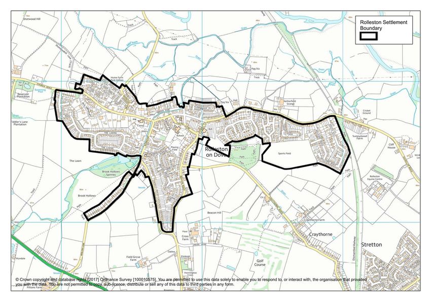
13Settlement Boundary
5.2 The village of Rolleston on Dove has a settlement boundary, produced by ESBC, the local authority. It
is envisaged that development will not take place outside of this boundary.
14Figure 5: Rolleston on Dove settlement Boundary Source: ESBC
15Transport
Buses
5.3 There are three bus routes through Rolleston on Dove, connecting the village with the city of Derby
and the nearby village of Tutbury. At the present time, none of the buses directly connect Rolleston on Dove
to the local hospital, Queens, part of the University Hospitals of Derby and Burton NHS Foundation Trust.
Figure 6: Bus routes through Rolleston on Dove
Num. Service (From/To) General Details Operator
1 Burton to Rolleston to Tutbury Hourly Mon to Sat Midland Classic
1 Tutbury to Rolleston to Burton Hourly Mon to Sat Midland Classic
401 Hatton to Burton via Rolleston Only this direction, Mon to Sat (2 trips) Midland Classic
V1 the villager Rolleston to Burton Every 30 mins M-S, hourly Sun & BH Mons Trent Barton
V1 the villager Rolleston to Derby Every 30 mins M-S, hourly Sun & BH Mons Trent Barton
Information correct as at April 2018
Main Roads
5.4 Church Road and Station Road form one long road from Tutbury to the A38.
5.5 Knowles Hill flows into Rolleston Road and is a major road into the main town of Burton upon
Trent.
There are three small lanes:
5.6 Anslow Lane connects the village to the A511 Tutbury Road.
5.7 Marston Lane is a very small, one lane thoroughfare that connects the village to the village of
Hilton in South Derbyshire.
5.8 Craythorne Road connects the village to Stretton.
Critical Traffic Points
5.9 Rolleston on Dove, although a village, is used as a main thoroughfare from Tutbury through to the
A38. Combined with John of Rolleston school traffic, there are various road junctions in the village that can
be classed as critical traffic junctions, or points, that is, there are many vehicles attempting to drive along,
turn into, turn out of at all times of the day, with particular emphasis on school and work timings.
5.10 These critical points are:
16• Station Road/School Lane. Visibility both left and right turning out of School Lane is restricted in
school times due to parked cars, plus the sheer number of vehicles travelling both ways along Station
Road.
• Station Road/Chapel Lane. Turning out of Chapel Lane, visibility both left and right is hampered,
particularly as there is a road chicane to the left.
• Anslow Lane/Burnside/Knowles Hill. Directly opposite are the Costcutter/Post Office and Co
Operative shops. Many shoppers use Anslow Lane as a turning point. Visibility to the left coming
out of Anslow Lane is reduced due to the bend in the road.
• Craythorne Road (Lane)/Beacon Drive. Craythorne Road is a narrow country road joining Rolleston
on Dove to Stretton. It is a very busy road. Visibility both left and right is restricted due to the nature
of the junction. It is particularly busy during school times as John of Rolleston School is at the end of
Beacon Road.
Figure 7: Critical Traffic Points
Source Streetmaps.co.uk
17Figure 8: (1) Station Road/School Lane
Figure 9: (2) Station Road/Chapel Lane
Figure 10: (3) Anslow Lane/Burnside/Knowles Hill
18Figure 11: (4) Craythorne Road/Beacon Road
Sources of all images: © Google Maps
Socio-economic profile
5.11 A full socio-economic profile can be found on the Borough Council’s website[4]. All information in this
section is taken from that source or from the 2011 Census.
Population
5.12 The 2011 Census gives a population for Rolleston of 3,267 of which 34.9% were aged 60 or over.
Rolleston on Dove has a large and rising population aged 60 and over as the same proportion in 2001 was
only 20%.
Housing
5.13 The 2011 Census identified 1,433 households in Rolleston on Dove. This is an increase of 7.1% on the
2001 Census figure. Due to small scale new housing development within the village, plus the latest
applications at the current time of the Neighbourhood Development Plan, there will be an increase in the
2021 census figures.
Economic activity
5.14 The aging population of the village is borne out by the fact that 66.0% of the population of Rolleston
are economically active compared to 70.5% of the population of East Staffordshire as a whole. Of those
residents who are economically active, 46.6% are classed as Managers, Professional or Technical. This figure
is significantly higher than that for East Staffordshire and for England and Wales. This is again borne out by
the fact that more than 35.7% of people in Rolleston are qualified to degree level or higher.
5.15 In 2008, the average household income across Rolleston on Dove was £44,800 which is significantly
more than the average across East Staffordshire of £36,800.
5.16 Rolleston on Dove has a very small business footprint and is therefore not a major local employer:
• Ian Barkers, butchers
• Hairdressers and beauty salon
• Rolleston Kindergarten
19• Costcutter, newsagents and shop with lottery
• Cooperative, retail shop with lottery
• Spread Eagle public house and restaurant
• The Jinnie Inn public house
• Rolleston on Dove Service Station
• John of Rolleston Primary School
• Post Office, located inside Costcutter
• Rolleston Club
5.17 There are some small home businesses within Rolleston on Dove, although the majority of
residents travel to work outside of the village.
Car ownership and travel to work
5.18 Car ownership in Rolleston on Dove is on average 1.5 vehicles, per household.
5.19 Because of the nature of employment of most of the workers, very few of them work in Rolleston on
Dove or from home. The vast majority (almost 80%) travel to work by private motor vehicle.
5.20 An issue raised through the community consultation was on street parking and the provision of
parking within new developments. Through the research of the Neighbourhood Development Plan, we have
identified a European standard that could be used to inform the size of onsite parking provision, ensuring
that any garages built are fit for purpose and capable of accommodating a range of vehicle sizes.
5.21 The European standard states:
Figure 12: European Car sizes
Vehicle Segment Percentage
A. Mini Cars 8.7
B. Small cars – small family car; suggested garage size internally 3x5 26
metres, ideal 3x6 metres
C. Medium cars 23
D. Large cars 11
E. Executive cars 3
F. Luxury cars 0.3
J. Sport utility cars (inc off road) 13
M. Multi purpose cars 13
S. Sports cars 1
Source: European Commission: (EU market share in 2011)
20Health
5.22 The residents of Rolleston tend to live a healthier lifestyle than the average in East Staffordshire and
England. The life expectancy of residents is almost three years more than the average for East Staffordshire
as a whole. This is in spite of the anecdotal evidence from local doctors that the Dove Valley is unhealthy
due to the damp environment. This increased life expectancy can only add to the problems of an increasing
aging population in the village.
5.23 There is currently no GP surgery within Rolleston on Dove village. The nearest GP is 1.36 miles away
in Stretton, which is outside the maximum acceptable distance (1.24 miles) for accessing services on foot as
recommended by the Institute of Highways and Transportation (IHT). In total, there are five GP surgeries
within a two-mile radius of Rolleston on Dove. At the time of this document (Jan 2018), only Tutbury Health
Centre are accepting new patients.
5.24 It is considered that significant new development would be unsustainable unless a GP surgery was
provided in Rolleston on Dove. The difficulty of travelling to the existing surgeries on foot means that
accessing health services is difficult for those without access to a car and creates increased car movements
for others. However, consultation with the South Staffordshire Primary Care Trust in late 2017 has confirmed
that they would have no interest in providing a new GP surgery or a satellite surgery in Rolleston on Dove at
the present time.
216. Land Use
Predominant Land Uses
6.1 The village of Rolleston on Dove is surrounded by working farm land with the inner village structure
being housing stock.
Housing Stock
6.2 Rolleston on Dove has been growing over many years (see Figure 3) and has a mix of housing stock
for predominantly private householders with an estate for mainly social housing householders. The social
housing estate includes four flats, which are the only flats in the village at the time of the initial
Neighbourhood Development Plan.
6.3 The housing stock, apart from the flats, consists of two, three, four and five bedroom houses,
including bungalows, with gardens and parking spaces.
Community Facilities
6.4 The village of Rolleston on Dove has many community facilities:
• Craythorne Playing Fields (owned by the Parish Council) comprising football pitches
• Rolleston Club, a private members club
• Rolleston Scouts, a scout meeting venue with outdoor facilities
• Play areas: Tafflands, Forest School Street and Elizabeth Avenue
• Brook Hollows
• The Old Grammar School
• The Cricket Club
• St Mary’s Church
• The Croft
Property and Land Prices
6.5 Rolleston on Dove, with an overall average price of £263,275 was more expensive than nearby
Stretton (£192,339), Tutbury (£224,665) and Burton-On-Trent (£173,774)[5]
6.6 During the last year (2017), sold prices in Rolleston on Dove were 5% down on the previous year and
similar to 2014 when the average house price was £262,110.
227. Environment
Conservation Area
7.1 The village of Rolleston on Dove has a Conservation Area.
7.2 Conservation Areas are defined within today’s current legislation as being ‘areas of special
architectural or historic interest, the character or appearance of which it is desirable to preserve or enhance’
[Planning (Listed Buildings and Conservation Areas) Act 1990: Section 69(1)(a)].
7.3 Rolleston on Dove Conservation Area was designated by Staffordshire County Council on 3rd March
1970. Currently, it is one of 25 Conservation Areas that have been designated within the Borough of East
Staffordshire.
7.4 Special consideration should be given to proposals for development or redevelopment within a
Conservation Area to ensure that its character and appearance are preserved or enhanced.
23Figure 13: Rolleston on Dove Conservation Area Source: ESBC
24Flooding
7.5 Within the Parish, flooding is an issue that the Neighbourhood Development Plan is keen to address
through policy. Any development should not increase flood risk.
7.6 The most up to date flooding information is available from The Environment Agency[6] and the River
Levels website[7]
7.7 The village has flooded as recently as March 2018, with one of the major artery roads, Station Road,
being closed to through traffic.
7.8 It has been identified by Staffordshire County Council in October 2014[8] that there are four main
drainage routes. These convey surface water from above the village and discharge into the floodplain to the
North of Station Road. However, there are two primary sources of flooding:
7.8.1 Flooding from the Rolleston Brook and River Dove. These main rivers overtop and cause flooding
in various locations and particularly Brookside. Both rivers are under the supervision of the Environment Agency.
There are flood forecasts available for 30 year and 75 year projections and these are in the Appendix.
7.8.2 Flooding from Beacon Hill and from surface water generally. As well as the fluvial flood risk
mentioned above. There are significant problems dealing with surface water and land drainage. This is mainly
caused by persistent and heavy rainfall on Beacon Hill. There are then only a small number of routes for water
to flow off the hill, through the village and join either the Rolleston Brook or the River Dove. The network of
pipes and drains is archaic and suffers in places from root infiltration, siltation and debris causing blockages.
Figure 14: Flooding
Junction of Chapel Lane and School Lane 13th March 2018
25Figure 15: Flooding
Brookside
Photographs © Burton Mail
Figure 16: Flooding
Brookside 6th July 2012
© youtube
26Figure 17: Flooding
Station Road July 2012
Climate Just http://www.climatejust.org.uk/case-studies/applying-climate-just-staffordshire
27Natural Assets and Environment
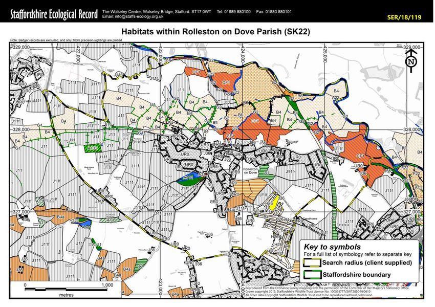
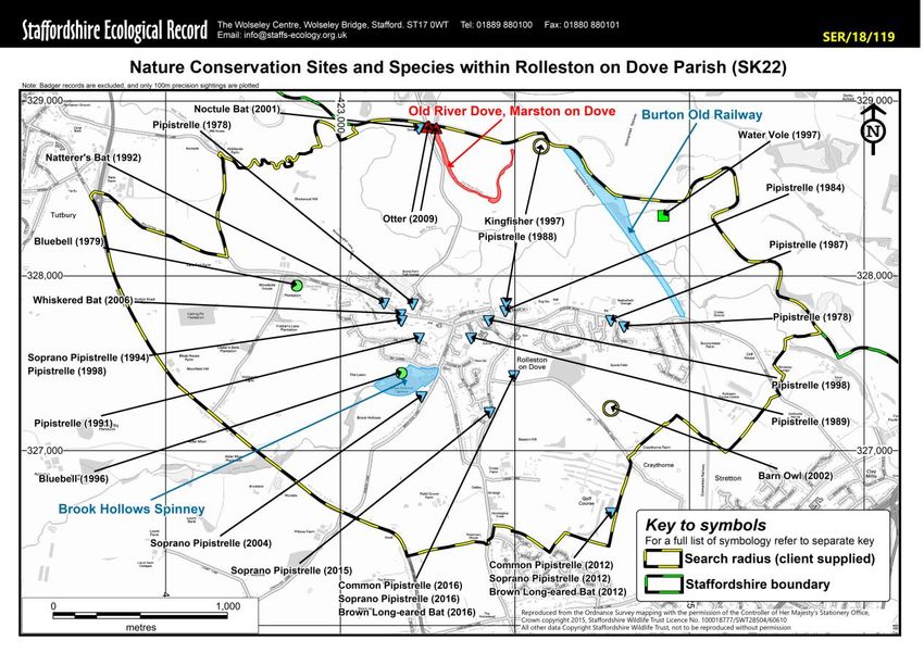
7.9 The Parish is host to a number of natural assets within the environment. The Neighbourhood
Development Plan seeks to protect and enhance these which include the Old Dove SSSI and the dismantled
Railway to the north of the Jinny Trail – this is listed as a Biodiversity Alert Site (BAS) indicating that it is of local
importance for wildlife - and a number of other features including wildlife areas, watercourse, orchards and
veteran trees and mature hedgerows. These collectively establish the village’s rural character and natural
environment.
7.10 Further details on the wildlife areas can be found in the information provided by Staffordshire Wildlife
Trust in the Appendix.
288. Policies
Housing
Rationale
8.1 East Staffordshire Borough Council (ESBC) is required to establish its housing requirements by using the
Office for National Statistics’ (ONS) 2010-based population projections and the Department for Community and
Local Government’s (DCLG) 2008-based household projections. This is then coupled with an assessment of sites
for development and infrastructure requirements to derive the Local Plan strategy. The vast majority of growth
in the Local Plan is focused in the two main centres of Burton upon Trent and Uttoxeter.
8.2 Using district-wide projections to underpin housing requirements at the parish level fails to take into
account the location of the Parish in relation to the main centres as well as the particular issues affecting such a
parish, for example the age of the population. This is a reflection largely of the fact that villages have a relatively
low stock of properties when compared to the main urban centres.
8.3 The approach that the Neighbourhood Development Plan has taken is to use this data where appropriate
and to combine it with consideration of the capacity of the key infrastructure which serves the village.
8.4 It is a fundamental principle of the Localism Act and the National Planning Policy Framework that
Neighbourhood Development Plans are permissive planning tools that must plan positively for growth. The
policies in the Rolleston on Dove Neighbourhood Development Plan seek to achieve this. The policies reflect a
process which the community has engaged with, fully understanding of the particular need to plan for future
growth over a plan period to 2033.
8.5 The Neighbourhood Development Plan process has not identified an overwhelming urge to only
accommodate the needs of local people or those with a local connection. Equally however, it has been strongly
felt by the community that Rolleston on Dove is not an appropriate location for significant growth in housing
that will make a major contribution to accommodating the wider housing needs of East Staffordshire. Rolleston
on Dove is a village and lacks the services to support such growth.
8.6 Rolleston on Dove’s proximity to Burton upon Trent has inevitably had the effect of restricting its growth
and the growth of services in the village. People from the wider catchment look to Burton upon Trent for many
of their basic services, not to Rolleston on Dove (see figure 4).
8.7 It is important that the housing growth proposed for Rolleston on Dove over the plan period is
appropriate in scale. The capacity of key services to absorb further growth is paramount. The levels of
development being considered have no viable prospect of providing for expansion in the capacity of these
services, so Rolleston on Dove’s changing population must be supported by the services as they are currently
provided.
8.8 The principal services that will experience the greatest direct impact as a result of new development are
John of Rolleston Primary School and the local GP health services.
29H1: Housing Development
All housing development will be considered for approval in sustainable locations. These are:
• Strategic site, allocated by the ESBC Local Plan shown on the Settlement Boundary map (page 15)
as sports field
• Within the settlement boundary of Rolleston on Dove;
• Small-scale infill development.
To be sustainable, development must:
• Not encroach into the open countryside;
• Not involve the loss of high grade agricultural land;
• Avoid encroaching onto or impacting on sensitive landscapes and habitats;
• Be supported by adequate infrastructure, or provide any necessary infrastructure improvements
as part of the development;
• Be directed away from those areas at highest flood risk, ie, towards the Flood Zone
Interpretation
The policy seeks to focus development into existing settlements and strategic sites allocated by the Local Plan.
This helps to make existing settlements more sustainable and prevents those settlements from encroaching into
the open countryside or from merging into each other.
The policy seeks to ensure future development takes into consideration the flooding risk.
Small scale infill could include up to three dwellings between two existing properties in a built up area.
Development which fills a gap in the continuity of existing building curtilages, normally residential, which
normally adjoin on at least two sides, and development within a village area which would not involve outward
extension. Infill schemes can in themselves only be complete schemes and cannot be the first stage of a large
development.
30H2: Housing Mix and Affordable Provision
Housing developments of two houses or more must include a balanced mix of house types to
meet local need. The mix of housing must include smaller dwellings to meet the needs of first
time buyers, the elderly and those wishing to downsize.
Developers must justify the mix of housing in any planning application based on evidence of
housing need.
Where a scheme includes affordable housing, it must be provided within the neighbourhood area
as an integral part of the development.
Interpretation
Developers will need to provide evidence of local need to support planning applications. The requirement for
affordable housing is set out in the policies of the Local Plan.
Smaller dwellings would be of one or two bedrooms. In consideration of housing mix the requirements for room
sizes and storage are set out in the government’s technical housing standards-nationally described space
standards, March 2015 (or any equivalent standard replacing or superseding that standard).
31Character and Design
8.9 A major challenge facing the future of Rolleston on Dove is to balance the desire to protect the charm of
the village with the need for the village to grow and evolve in a sensitive manner. The policies in this section
seek to reflect the simple design principles which the community has considered will help to achieve this aim.
8.10 The Parish of Rolleston on Dove’s landscape is dominated by green open spaces and mature trees. It is
considered that these principles should be continued with usable green areas of public open space being
designed to effectively integrate with the private dwellings on new residential developments. This is only
effective on developments of a reasonable scale. It is therefore considered that developments of less than ten
dwellings will not have to provide public open space unless there is a lack of public open space within close
proximity. However, if such developments do provide public open space when they are not required to, then
they should be viewed more favourably.
8.11 It is considered that these requirements provide the best prospect of maintaining these principles.
8.12 These aspirations to maintain the character and appearance of the rural settlement are further echoed
in the responses from community engagement, which stated that “it is ‘highly important’ to have open and green
spaces inside the village”, “to enjoy being able to walk out of a front door and being able to walk in open
countryside within a few minutes”, “Rolleston has a fantastic village community and the friendly identity is
because of the relatively small size of the lovely village” and “Rolleston is a pretty village - I feel happy and proud
to tell people I live here”. In the Environment section earlier in the Neighbourhood Development Plan we identify
key views, the importance of the Conservation Area and other assets within the Neighbourhood Area that could
be further protected or enhanced through the policies of this Neighbourhood Development Plan. Similarly key
issues to be addressed of which some relate to design and character were also identified shown in the
Community and Stakeholder section of the Neighbourhood Development Plan.
8.13 The adopted Local Plan further supports and promotes high quality design in all new development
through the policies of the adopted Local Plan and complemented by the adopted Supplementary Planning
Document on Design, which informs any new development. The adopted Local Plan also highlights the
importance of good community engagement in new development encouraging developers to:
“Discuss their development proposals with a local community through public participation in
order to inform the design of a new development.”
(p136, Adopted Local Plan, 2012-2031G, Planning for Change, Adopted 15th October 2015)
8.14 As part of this process the Neighbourhood Development Plan seeks to provide a clear steer to inform
that process through its policies. These principles are also supported at a national level with the National
Planning Policy Framework (NPPF) [9] supporting the local evidence base as in Paragraph 124 of the NPPF which
states that:
“Planning policies and decisions should support the creation of high quality buildings and places. Plans
should, at the most appropriate level, set out a clear design vision and expectations, so that applicants
have as much certainty as possible about what is likely to be acceptable. Design policies should be
developed with local communities so they reflect local aspirations, and are grounded in an
understanding and evaluation of each area’s defining characteristics. Neighbourhood plans can play an
important role in identifying the special qualities of each area and explaining how this should be
reflected in development.”
32“Good design is a key aspect of sustainable development [and] is indivisible from good planning”. It
recognises that well-designed buildings and places improve the quality of people’s lives and that it is a
core planning principle always to secure good design, particularly where developments are in an
isolated location.”
8.15 It goes on to acknowledge in paragraph 126 that:
“Planning policies and decisions should ensure that developments:
a) will function well and add to the overall quality of the area, not just for the short term but over the
lifetime of the development;
b) are visually attractive as a result of good architecture, layout and effective landscaping;
c) respond to local character and history, including the surrounding built environment and landscape
setting, while not preventing or discouraging appropriate innovation or change (such as increased
densities);
d) establish or maintain a strong sense of place, using the arrangement of streets, spaces, building
types and materials to create attractive and distinctive places to live, work and visit;
e) optimise the potential of the site to accommodate and sustain an appropriate amount and mix of
development (including green and other public space) and support local facilities and transport
networks; and
f) create places that are safe, inclusive and accessible, with a high standard of amenity for existing and
future users; and where crime and disorder, and the fear of crime, do not undermine the quality of life
or community cohesion and resilience.”
8.16 For Rolleston on Dove, these requirements are interpreted in the following design policies of this plan.
33D1: Green Infrastructure
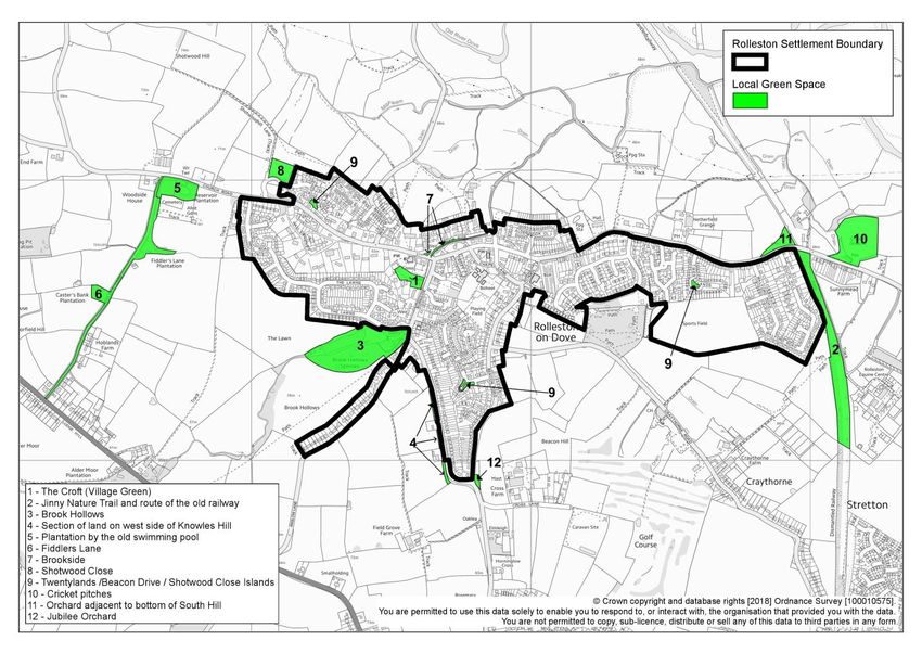
Access to high quality green spaces and environmental assets is an important element of sustainability
and a key characteristic of the Parish. Development proposals must deliver access to, or contribute to
enabling access to such assets through s106 or Community Infrastructure Levy CIL contributions
where this is viable and deliverable.
This may include improvements or access to:
• designated Local Green Spaces;
• existing footpaths and bridleways; and
• existing cycle network.
Planning applications for new development must also be supported by an assessment of the level of
informal outdoor space that proposals should deliver.
When considering planning applications it is desirable to preserve and enhance important green
elements (space, trees, etc.) that form part of the overall kinetic and spatial experience of
Rolleston on Dove.
On site contributions to open space and green infrastructure should be used in the neighbourhood
area.
New development must retain and enhance river floodplains and habitats and any open watercourses
should not be culverted. Where possible, opportunities should be taken to open up any existing
culverts to reduce the associated flood risk and danger of collapse as well as enhancing biodiversity and
green infrastructure.
Interpretation
This policy sets out green infrastructure priorities.
34D2: Design of New Development
All development must deliver good quality design. In order to achieve this, all development must:
• Comprise site specific design to complement the character of the village, rather than generic
design solutions that fail to respond to local character;
• Complement and integrate with the local surroundings in terms of scale, height, massing, spacing
and set-back from street frontages;
• Provide active frontages to streets and public spaces, so as to provide natural surveillance;
• Create attractive, safe, and convenient pedestrian environments:
• Provide screened bin storage, away from road frontages;
• Use permeable materials for hard surfaces;
• Incorporate sustainable drainage systems (SuDS) to reduce flood risk and manage
surface water and to ensure that runoff does not increase the risk of flooding
elsewhere. Long-term maintenance arrangements for all SuDS should also be in
place for the lifetime of the development and agreed with the relevant risk
management authority.
• Existing open watercourses should not be culverted. Where feasible,
opportunities to open up culverted watercourses should be sought to reduce the
associated flood risk and danger of collapse whilst taking advantage of
opportunities to enhance biodiversity and green infrastructure.
• Use high quality and authentic materials to complement the existing palette of materials used
in the surrounding area;
• Retain existing hedges and trees and design boundary treatments to complement the established
local character, especially on the edge of the countryside, to create a soft-edge
transition between built area and open landscape; and
• Respond to site orientation and microclimate.
• Creative, contemporary design solutions are particularly encouraged, especially where they
incorporate superior environmental performance.
Interpretation
Policy D2 is concerned with sustainable design principles. It seeks to promote sustainability by addressing
character, local distinctiveness, amenity, safety, and pedestrian convenience. Analysis of the site and context is
an essential part of the design process.
35You can also read