Control of oceanic circulation on sediment distribution in the southwestern Atlantic margin (23 to 55 S)
←
→
Page content transcription
If your browser does not render page correctly, please read the page content below
Ocean Sci., 17, 1213–1229, 2021
https://doi.org/10.5194/os-17-1213-2021
© Author(s) 2021. This work is distributed under
the Creative Commons Attribution 4.0 License.

Control of oceanic circulation on sediment distribution in the
southwestern Atlantic margin (23 to 55◦ S)
Michel Michaelovitch de Mahiques1,2 , Roberto Violante3 , Paula Franco-Fraguas4 , Leticia Burone4 ,
Cesar Barbedo Rocha5 , Leonardo Ortega6 , Rosangela Felicio dos Santos1 , Bianca Sung Mi Kim1 ,
Rubens Cesar Lopes Figueira1 , and Marcia Caruso Bícego1
1 Oceanographic  Institute of the University of São Paulo, 05508-120, São Paulo, Brazil
2 Instituteof Energy and Environment of the University of São Paulo, 05508-010, São Paulo, Brazil
3 Servicio de Hidrografia Naval, C1270ABV, Buenos Aires, Argentina
4 Facultad de Ciencias, Universidad de La Republica, 11400 Montevideo, Uruguay
5 Department of Marine Sciences, University of Connecticut, Groton, CT 06340, USA
6 Departamento de Biología Pesquera, Dirección Nacional de Recursos Acuáticos, 11200 Montevideo, Uruguay

Correspondence: Michel Michaelovitch de Mahiques (mahiques@usp.br)

Received: 11 May 2021 – Discussion started: 1 June 2021
Revised: 18 August 2021 – Accepted: 25 August 2021 – Published: 15 September 2021

Abstract. In this study, we interpret the role played by ocean     ment sources and transport is provided for the southwestern
circulation in sediment distribution on the southwestern At-       Atlantic margin.
lantic margin using radiogenic Nd and Pb isotopes. The lati-
tudinal trends for Pb and Nd isotopes reflect the different cur-
rent systems acting on the margin. The utilization of the sed-
iment fingerprinting method allowed us to associate the iso-       1   Introduction
topic signatures with the main oceanographic features in the
area. We recognized differences between Nd and Pb sources          Physical and oceanographic processes, including ocean cur-
to the Argentinean shelf (carried by the flow of Subantarctic      rent circulation, river discharge, marine fronts, wind patterns,
Shelf Water) and slopes (transported by deeper flows). Sed-        and climate variability, have a crucial impact on sediment
iments from Antarctica extend up to the Uruguayan margin,          transport variability and fate (Storlazzi and Reid, 2010; Qiao
carried by the Upper and Lower Circumpolar Deep Water.             et al., 2020). The southwestern Atlantic margin is located in
Our data confirm that, for shelf and intermediate areas (the       a key region concerning global ocean circulation and is an
upper 1200 m), the transfer of sediments from the Argen-           excellent example of a complex interaction of physical forc-
tinean margin to the north of 35◦ S is limited by the Sub-         ings in the sediment variability. Hydrodynamics are strongly
tropical Shelf Front and the basin-wide recirculated Antarc-       influenced by the Río de la Plata (RdlP) outflow, the second-
tic Intermediate Water.                                            largest river basin in South America (discharge estimated at
   On the southern Brazilian inner and middle shelf, it is pos-    23 000 m3 s−1 ; Depetris and Griffin, 1968), and by the en-
sible to recognize the northward influence of the Río de la        counter of subtropical and subantarctic water masses trans-
Plata sediments carried by the Plata Plume Water. Another          ported by the Brazil and Malvinas currents, which is known
flow responsible for sediment transport and deposition on          worldwide as Brazil—Malvinas Confluence (BMC); there is
the outer shelf and slope is the southward flow of the Brazil      also an influence by the BMC’s shelf extension, the Sub-
Current. Finally, we propose that the Brazil–Malvinas Con-         tropical Shelf Front (STSF). At the BMC, water masses are
fluence and the Santos Bifurcation act as boundaries of geo-       transported eastwards as part of the southern limb of the
chemical provinces in the area. A conceptual model of sedi-        basin-wide Anticyclonic Atlantic Subtropical Gyre (Boebel
                                                                   et al., 1997; Schmid et al., 2000). Further north, the west-
                                                                   ward flow of the gyre reaches the South American margin,

Published by Copernicus Publications on behalf of the European Geosciences Union.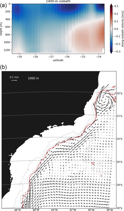
1214                                     M. M. de Mahiques et al.: Control of oceanic circulation on sediment distribution

where it splits into two branches, forming the Santos Bifur-
cation (SB; Boebel et al., 1999a; Legeais et al., 2013). The
southward branch of the bifurcation feeds the Brazil Current
(BC), flowing south until its eastward displacement at the
BMC (Schmid et al., 2000). The northward branch flows as
the Intermediate Western Boundary Current (IWBC) (Leg-
eais et al., 2013), which is an important mechanism for the
transport of the Antarctic Intermediate Water towards the
Northern Hemisphere (Boebel et al., 1999b).
   Even though the distribution of sediments, sources,
and transport along the southwestern Atlantic margin has
been known since the 1950s (Teruggi, 1954; Etchichury
and Remiro, 1960, 1963; Berkowsky, 1978; Kowsmann
and Costa, 1979; Urien and Martins, 1979; Potter, 1984;
Berkowsky, 1986) and recently deepened based on geochem-
ical and mineralogical methods (Campos et al., 2008; de
Mahiques et al., 2008; Razik et al., 2013; Nagai et al., 2014a)
important issues regarding hydrological controls are still un-
resolved.
   Radiogenic Nd and Pb isotopes are efficient tools in study-
ing sediment transport in continental margins (Weldeab et al.,
2002; Kessarkar et al., 2003; Maccali et al., 2012, 2018;         Figure 1. Location of the study area, displaying the main flows,
Subha Anand et al., 2019). A recent synthesis of potential        oceanographic boundaries, and sampling stations. Thick violet line:
sources and water mass transport in the South Atlantic was        Malvinas Current (MC); thin blue line: Subantarctic Shelf Water
provided by Beny et al. (2020). In that study, the authors        (SASW); thin brown line: Río de la Plata Plume (RdlPP); thick
combined grain size, clay mineralogy, and Nd, Pb, and Sr          red line: Brazil Current (BC); shaded rectangles: Subtropical Shelf
                                                                  Front (STSF) and Brazil–Malvinas Confluence (BMC); dashed red
isotopes to propose a deepwater mass evolution for the last
                                                                  line: Santos Bifurcation (SB) and Intermediate Western Boundary
ca. 30 000 years in the region. The first regional character-     Current (IWBC). Other abbreviations: Antarctic Intermediate Wa-
ization of Nd and Pb isotope signatures of the upper mar-         ter (AAIW), Upper Circumpolar Deep Water (UCDW), North At-
gin surface sediments in the southwest Atlantic was provided      lantic Deep Water (NADW), and Lower Circumpolar Deep Water
by de Mahiques et al. (2008), filling a gap for an exten-         (LCDW). Bottom scale: topography in meters.
sive area without information about εNd signatures (Jean-
del et al., 2007; Blanchet, 2019). In that work the authors
(1) recognize the isotopic signatures of the sediments from       STSF, BMC, and BS in the distribution of sediments. The
the Argentinean, southern, and southeastern Brazilian mar-        results are interpreted with the aid of the output of a state-of-
gins; and (2) describe potential source areas of the sediments,   the-art circulation model to understand the role of oceano-
such as the Andes, the basalts of the Paraná Basin, and the       graphic boundaries in the distribution of sediments along the
pre-Cambrian rocks of the Brazilian shield.                       area.
   Notwithstanding, geographic gaps in information preclude
a thorough understanding of the role of key hydrological fea-
tures such as the STSF, BMC, and SB in the sediment dis-          2     Study area
tribution and the associated geochemical boundaries, which
are key for paleoceanographic studies. Moreover, in another       The study area comprises a southwestern Atlantic margin
approach for sediment sources and pathways in the south-          sector from the parallels 23◦ 000 S to 54◦ 100 S, correspond-
western Atlantic margin provided by Razik et al. (2015), the      ing to a linear extension of about 3500 km (Fig. 1). Synthe-
authors argued for a mixed Río de la Plata–Andean origin for      ses of the main geological and oceanographic processes can
the upper slope sediments off southern Brazil.                    be found in Hernandez-Molina et al. (2009, 2015), Franco-
   In this paper, we extend the Nd and Pb dataset along the       Fraguas et al. (2014, 2016), Nagai et al. (2014a, b), Violante
southwestern Atlantic margin and use the concept of sedi-         et al. (2014, 2017a), Burone et al. (2018), Piola et al. (2018),
ment fingerprinting to deepen the role played by hydrody-         and Piola and Matano (2019), among several others.
namic forcing in sediment transport and deposition. The ge-
ographical distribution of the new samples presented here,        2.1    Morphology
covering the Argentinean margin and the Punta del Este,
Pelotas, and Santos basins and covering a bathymetry range        The southwestern Atlantic margin is a typical segmented
between 5 and 4066 m, allows focusing on the role of the          volcanic-rifted margin, where several transverse basins are

Ocean Sci., 17, 1213–1229, 2021                                                       https://doi.org/10.5194/os-17-1213-2021
M. M. de Mahiques et al.: Control of oceanic circulation on sediment distribution                                            1215

recognized (Bassetto et al., 2000; Moulin et al., 2010; Soto        processes occurring across- (gravitational) and along- (con-
et al., 2011). Its origin and evolution are intrinsically related   touritic) slope, together with pelagic sedimentation (Violante
to the opening of the South Atlantic (Nürnberg and Müller,          et al., 2010; Bozzano et al., 2011; Franco-Fraguas et al.,
1991), whose rifting processes first started in the Triassic        2016; Schattner et al., 2020). However, coarse sands and
(Lovecchio et al., 2020) but effectively occurred during the        gravels occur at or near the head of submarine canyons and
Jurassic and Cretaceous.                                            in contouritic channels and moats (Lonardi and Ewing, 1971;
   There is a general trend of narrowing the margin towards         Bozzano et al., 2011; Reis et al., 2016; Franco-Fraguas et al.,
the north (Urien and Ewing, 1974; Zembruscki, 1979; Parker          2017). Razik et al. (2015) indicate increasing grain size to-
et al., 1996; Violante et al., 2017a). The shelf width varies       wards coarse sands due to sediment remobilization and redis-
from 850 km to the south to 70 km in its northernmost limit;        tribution due to upwelling and downwelling resulting from
the shelf-break depth ranges from 80 m in southern Brazil           eddies and vertical water movement generated by the slope
to 200 m in Uruguay (Zembruscki, 1979; Muñoz et al., 2010;          off southern Brazil and the meandering Brazil Current.
Lantzsch et al., 2014). The shelf morphology is relatively flat,
but sequences of scarps and terraces are recognized along           2.3   Ocean circulation
the continental shelf at varying water depths (Corrêa, 1996;
Parker et al., 1996; Baptista and Conti, 2009).                     The southwestern Atlantic margin is characterized by com-
   The continental slope presents a highly variable morphol-        plex hydrography (Matano et al., 2010). It presents two
ogy, including contouritic terraces, channels, mounds, ero-         main oceanographic boundaries, the Subtropical Shelf Front
sive surfaces, and sediment drifts all along the area (Duarte       (STSF), as the shelf extension of the Brazil—Malvinas Con-
and Viana, 2007; Hernández-Molina et al., 2010, 2015; Preu          fluence (BMC) (Piola et al., 2000; Severov et al., 2012),
et al., 2013) as well as canyons (Voigt et al., 2013; Boz-          and the less-studied Santos Bifurcation (SB) (Boebel et al.,
zano et al., 2017; Franco-Fraguas et al., 2017; Violante et al.,    1997, 1999a). The region is also influenced by the Río de
2017b; Warratz et al., 2019). The contouritic features and          la Plata (RdlP), the second-largest hydrographic basin in
submarine canyons actively interact along the margin so that        South America, whose average discharge is 22 000 m3 s−1
mixed contouritic–gravitational erosive and depositional fea-       (Framiñan and Brown, 1996). This regional circulation sys-
tures are common. Mega-slides (Reis et al., 2016; Franco-           tem experiences seasonal latitudinal shifts in response to
Fraguas et al., 2017) and carbonate mounds (Carranza et al.,        wind regimes (Schmid et al., 2000; Piola and Matano, 2001;
2012; Maly et al., 2019; Steinmann et al., 2020) are also           Piola et al., 2018).
present along the margin.                                              At the BMC, centered at 37–39◦ S (Maamaatuaiahutapu
                                                                    et al., 1992), the southward-flowing Brazil Current (BC)
2.2   Sedimentary cover                                             encounters the northward-flowing Malvinas Current (MC)
                                                                    (Schmid and Garzoli, 2009), transporting and mixing wa-
The southwestern Atlantic margin is dominated by a ter-             ter masses with contrasting thermohaline characteristics. The
rigenous, siliciclastic sedimentary cover, with extensive           BC is a baroclinic boundary current that concentrates its
sand sheets (Lonardi and Ewing, 1971; Frenz et al., 2003;           main flow in the upper 500 m of water depth upstream
Figueiredo and Madureira, 2004). The Argentinean and                of 28◦ S, carrying the Tropical Water (TW) at the surface
Uruguayan shelves are capped mainly by a 5 to 15 m thick            (Emilsson, 1961; Palma et al., 2008) and the South Atlantic
post-Last Glacial Maximum transgressive sandy sheet (with           Central Water (SACW) at pycnoclinic levels (Emilsson,
decreasing thickness towards the south) composed of domi-           1961; Signorini, 1978). Near the BMC, a significant frac-
nant medium to fine sands (sometimes muddy), with varying           tion of the BC transport is below 500 m. The MC is a strong
quantities of shells (more abundant in the Uruguayan shelf)         barotropic boundary current that advects the Subantarctic
and gravels (more abundant in the Patagonian shelf).                Water (SAW) near the surface (Spadone and Provost, 2009)
   Sandy and shelly sediments are mainly relicts of coastal         and the Antarctic Intermediate Water (AAIW) at intermedi-
and inner shelf environments that evolved during Pleis-             ate levels (Tomczak and Godfrey, 1994b, a).
tocene transgressive–regressive events (Kowsmann and                   At the BMC, water masses are transported eastwards as
Costa, 1979; Urien et al., 1980; Lantzsch et al., 2014). There-     part of the southern limb of the basin-wide Anticyclonic At-
fore, they are considered relict and palimpsest, whereas grav-      lantic Subtropical Gyre (Boebel et al., 1997, 1999a; Schmid
elly dominated sediments on the southern Argentinean shelf          et al., 2000; Núñez-Riboni et al., 2005; Legeais et al., 2013).
result from glaciofluvial origin. More recent works empha-          At the intermediate levels of the westward flow of the gyre,
size the existence of mud depocenters as potential fates of         the water reaches the South American margin near 28◦ S,
modern sediments on the southern Brazilian shelf (Nagai             where it splits into two branches, forming the Santos Bi-
et al., 2014a; de Mahiques et al., 2017, 2020; Lourenço et al.,     furcation (Boebel et al., 1999a; Legeais et al., 2013). From
2017).                                                              the bifurcation, one-quarter of the transport at 40◦ W flows
   In the slope and rise, there is a prevalence of very fine        northward along the continental slope (mainly between the
sands and silty sands, resulting from exclusively submarine         800 and 1200 m isobaths), forming the Intermediate West-

https://doi.org/10.5194/os-17-1213-2021                                                        Ocean Sci., 17, 1213–1229, 2021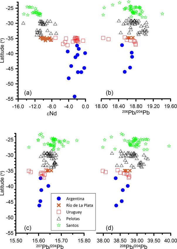
1216                                     M. M. de Mahiques et al.: Control of oceanic circulation on sediment distribution

ern Boundary Current (IWBC) (Fernandes et al., 2009; Biló          veys on board the research vessels Alpha Crucis (Brazilian
et al., 2014). About three-quarters feed the BC, flowing south     margin), Miguel Oliver, Capitán Saldaña, and Sarmiento de
until its separation from the coast at the BMC (Schmid et al.,     Gamboa (Uruguayan margin). Only the superficial samples
2000; Piola and Matano, 2019). This configuration leads to         (the upper 1 cm) of each core were used in this work.
an overall southward flow on the outer shelf and the outer to         The Nd and Pb isotopic analyses of the lithogenic fraction
middle slope from 28◦ S up to the BMC.                             were conducted at the Geochronological Research Centre of
   Concerning deep circulation, the North Atlantic Deep Wa-        the University of São Paulo, Brazil.
ter (NADW) (Sverdrup et al., 1942), transported from the              All chemical procedures were performed in a class 10 000
Northern Hemisphere high latitudes by the Deep Western             clean room equipped with laminar flow hoods of class 100.
Boundary Current, occupies the region between the 2000 and         All reagents were purified before use. Water was distilled and
3000 m isobaths. The NADW flows between two northward-             then purified on a Milli-Q system (® Millipore Corporation)
flowing branches of the Circumpolar Water (i.e., Upper and         (“ultrapure” water – “Type 1”). The acids were purified in
Lower Circumpolar Deep Water). The abyssal circulation             sub-boiling distillers (DST-1000, ® Savillex) and sub-boiling
(> 3500 m) is dominated by the Antarctic Bottom Water              stills (®Savillex) at low temperatures.
(AABW), which is partially trapped in the Argentine Basin             All of the samples were previously decarbonated with
(Tarakanov and Morozov, 2015).                                     HCl. Sediment powder (70 mg) was dissolved with HF,
   Over the shelf, the extension of the BMC, known as the          HNO3 , and HCl acids. Dissolution was done on a MARS-5
Subtropical Shelf Front (STSF), separates Subtropical Shelf        microwave oven. Both Pb and Nd were purified by the ion ex-
Water (STSW, formed by the mixture of the TW and SACW)             change technique. The first stage of ion exchange chromatog-
and Subantarctic Shelf Water (SASW) (Piola et al., 2000).          raphy involves separating Pb from the other matrix elements
This narrow and sharp front extends between 32◦ S at 50 m          using columns packed with anion exchange AG1-X8, 200–
of water column depth and 36◦ S over the shelf break, and its      400 mesh (Biorad) resin. After Pb collection, the remaining
position appears to be stable throughout the year (Piola et al.,   solution is dried out, and the residue is retaken to separate
2000; Berden et al., 2020). The main branch of the STSF is         the rare Earth elements (REEs) using RE resin (EIChroM In-
mixed with waters transported by the BC and exported off-          dustries Inc.) from the bulk solution. Nd was then separated
shore along with the BMC. A secondary branch is diluted            using Ln resin (EIChroM Industries Inc.).
with the PPW and TW and returns along the shelf (Berden               Pb isotopic compositions were measured on a Finnigan
et al., 2020).                                                     MAT 262 mass spectrometer. Samples were loaded
   At the surface, the low-salinity RdlP plume flows north-        on Re filaments with H3 PO4 and silica gel. Every
ward along the inner Uruguayan continental shelf during the        single analysis consisted of 60 ratio measurements.
austral winter. In the summer and during El Niño events, the       The Pb ratios were corrected for mass fractionation
plume remains off the RdlP mouth and extends along the en-         of 0.13 % a.m.u.−1 based on repeated analysis of the
tire upper continental margin (Piola et al., 2000, 2005; Möller    NBS-981         standard      (206 Pb/204 Pb = 16.893 ± 0.003,
et al., 2008).                                                     207 Pb/204 Pb = 15.432 ± 0.004,                            and
                                                                   208 Pb/204 Pb = 36.512 ± 0.014; n = 11), which yielded

                                                                   mass discrimination and fractionation corrections of
3     Materials and methods                                        1.0024 (206 Pb/204 Pb), 1.0038 (207 Pb/204 Pb), and 1.0051
                                                                   (208 Pb/204 Pb). The combination of these uncertainties and
3.1    Geochemical analyses                                        within-run uncertainties is typically 0.15 %–0.48 % for
                                                                   206 Pb/204 Pb, 0.13 %–1.07 % for 207 Pb/204 Pb, and 0.10 %–

The samples were organized in five distinct sectors in this        0.45 % for 208 Pb/204 Pb, all at the 2σ (95 %) confidence
study, corresponding to the Santos, Pelotas, and Punta del         level. The total Pb blank contribution, < 1 ng, is negligible.
Este marginal basins, the RdlP estuary, and the Argentinean           The Nd analyses, here reported as εNd values, were pre-
margin. Due to the small number of samples, the sediments          pared with standard methods according to the analytical pro-
from Argentina were not divided into the corresponding sed-        cedures described by Sato et al. (1995) and Magdaleno et al.
imentary basins (Fig. 1). Geographic coordinates and water         (2017), involving HF–HNO3 dissolution plus HCl cation ex-
depth of the samples are presented in the Supplement.              change using a Teflon powder column to separate REEs. No
   The results of 156 sediment samples were used as a              visible solid residues were observed after dissolution. Sam-
dataset, including 83 new samples, 53 samples published in         ples with incomplete dissolution were discarded.
de Mahiques et al. (2008), 6 samples published in Basile et al.       Nd determinations were performed on a Thermo Nep-
(1997), 8 samples published in Franco-Fraguas et al. (2016),       tune Plus ICP-MS. Nd isotopic ratios (143 Nd/144 Nd) were
and 3 core top samples published in Lantzsch et al. (2014).        normalized to the value of 146 Nd/144 Nd = 0.7219 (De-
The analytical methods used in those ancillary papers are          Paolo, 1981) and 143 Nd/144 Nd = 0.512103 of the JNDi-1
described in the original references. The new samples were         standard (laboratory average of the last 12 months). Usu-
collected with box corers and multiple corers in distinct sur-     ally, a single analysis consisted of 60 measurements of

Ocean Sci., 17, 1213–1229, 2021                                                       https://doi.org/10.5194/os-17-1213-2021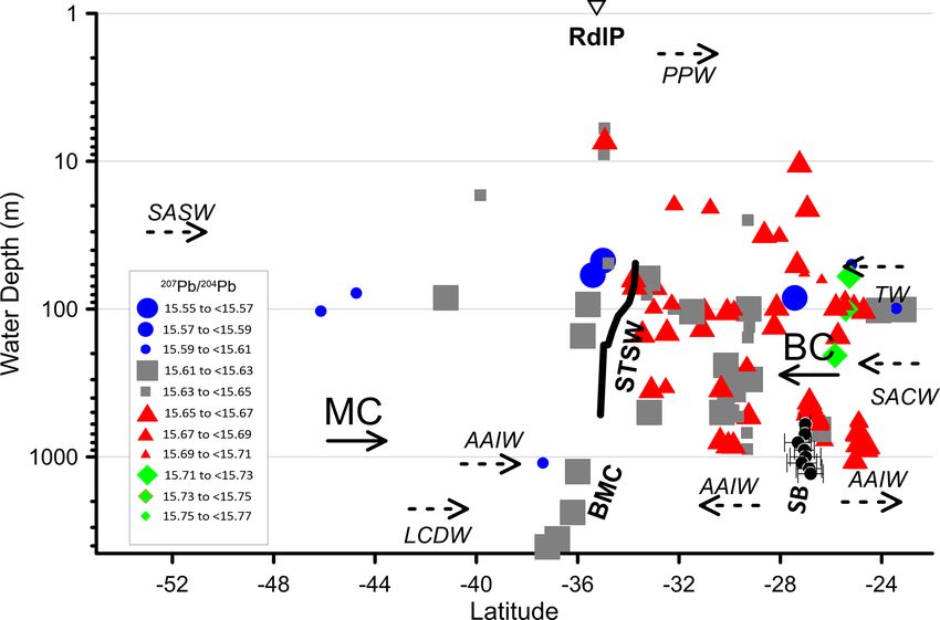
M. M. de Mahiques et al.: Control of oceanic circulation on sediment distribution                                               1217

Nd. The 143 Nd/144 Nd mean average of the JNDi stan-
dard during the analyses was 0.512095 ± 0.000007 (n = 3)
and 0.512096 ± 0.000005 between July and November 2013
(n = 56). The daily average of 143 Nd/144 Nd of the JNDi-1
standard was 0.512101 ± 0.000002 (n = 18). The analytical
blank during the analyses varied from 51 to 53 pg.
   The parameter εNd was calculated as follows:
   εNd = ((143 Nd/144 Ndsample /143 Nd/144 NdCHUR ) − 1) ×
104 , where 143 Nd/144 NdCHUR = 0.512638 (Jacobsen and
Wasserburg, 1980).
   Reproducibility analysis was made for both Pb and Nd iso-
topes using Buffalo River sediment (NIST-RM8704) (n = 7),
with the following results.
   143 Nd/144 Nd = 0.51203 ± 0.00001 (SD)
   206 Pb/204 Pb = 18.846 ± 0.018 (SD)
   207 Pb/204 Pb = 15.646 ± 0.005 (SD)
   208 Pb/204 Pb = 38.503 ± 0.016 (SD)

   Statistical analyses were performed using the software
PAST (Palaeontological Statistics) version 4.05 (Hammer
et al., 2001).
   To recognize the distinct isotopic domains over the study
area, we applied the geochemical fingerprinting procedure,
similar to the approaches proposed by Walling (2013), Miller
et al. (2015), and Palazon and Navas (2017). First, a Kruskal–
Wallis nonparametric analysis of variance was applied for
each variable, followed by a Mann–Whitney pairwise post
hoc test to identify which variables presented statistically
significant differences. Finally, a discriminant analysis with
standardized values was used to determine the correct classi-
fication for the previously assigned groups.
                                                                 Figure 2. Box plots of the distributions of (a) εNd,
3.2   The LLC2160 circulation model                              (b) 206 Pb/204 Pb, (c) 207 Pb/204 Pb, and 208 Pb/204 Pb. Outliers are
                                                                 shown as dots.
To support the geochemical data distribution interpretation,
we analyzed the output of the LLC2160 simulation, a global
1/24◦ forward run of the Massachusetts Institute of Technol-     We emphasize that the SB is not a stagnation point at which
ogy General Circulation Model (MITGCM) that was spun up          the flow is zero but a shadow zone that spans nearly 100 km,
from Estimating the Circulation and Climate of the Ocean         wherein the intermediate flow is feeble (see the schematic
(ECCO). The ECCO state estimate is similar to an ocean re-       SB in Fig. 1). In our discussion below, we present the mean
analysis and assimilates millions of observations, starting in   position and the latitudinal extension of the SB as a function
1992. With 90 vertical levels and a horizontal resolution of     of depth.
about 4 km in the South American margin, the LLC2160 sim-           To identify the mean position of the STSF, we searched
ulation resolves the main ocean circulation features on the      for the local maximum of the potential temperature gradient,
continental slope and shelf of the southwestern Atlantic. Our    which is a very distinct feature on the northern Argentina–
analysis focuses on a 12-month average spanning September        southern Brazil shelf. We compute the potential temperature
2011 through August 2012. Details of the simulation, includ-     gradients at 40 m to avoid contamination by RdlP water (e.g.,
ing a description of the spin-up hierarchy and forcing, are      Piola et al., 2008). When applied to the LLC2160 output us-
available in Chen et al. (2018).                                 ing seasonal averages, our method yielded frontal locations
   We used annual mean fields of the LLC2160 simulation          consistent with those identified by applying the isothermal
to identify two key features: the Santos Bifurcation (SB) and    criteria at 40 m proposed by Piola et al. (2008). In the yearly
the Subtropical Shelf Front (STSF). The SB is recognized as      fields, the front approximately follows the 14 ◦ C isotherm.
the region on the continental slope where the flow within the
AAIW depth range (550–1400 m) is negligible. Specifically,
we search different isobaths ranging from 500 to 1500 m for
the region where the AAIW flow is weaker than 0.01 m s−1 .

https://doi.org/10.5194/os-17-1213-2021                                                        Ocean Sci., 17, 1213–1229, 2021
1218                                       M. M. de Mahiques et al.: Control of oceanic circulation on sediment distribution

                                                                      Figure 4. Scatter plot of the samples according to the first two axes
                                                                      generated from the discriminant analysis.

                                                                         From the Kruskal–Wallis analysis, we observe that except
                                                                      for 206 Pb/204 Pb, the variables show significant differences
                                                                      among the compartments, thus allowing us to proceed with
                                                                      the discriminant analysis. Furthermore, the Mann–Whitney
                                                                      analysis allowed us to recognize the pairwise differences
                                                                      among the other variables (Table 1). Finally, it is to be noted
                                                                      that sediments from Argentina showed statistically signifi-
                                                                      cant differences with all of the variables analyzed, suggesting
                                                                      that they are distinct from those located towards the north. On
Figure 3. Latitudinal variations of (a) εNd, (b) 206 Pb/204 Pb,       the other hand, sediments from the Río de la Plata are statis-
(c) 207 Pb/204 Pb, and 208 Pb/204 Pb.                                 tically similar to those from the Pelotas sector for all of the
                                                                      variables.
                                                                         The first two axes of the discriminant analysis account
4   Results                                                           for 99.72 % (99.09 % for axis 1) of the total variance con-
                                                                      sidering the standardized values of εNd,207 Pb/204 Pb, and
                                                                      208 Pb/204 Pb (Fig. 4). It is possible to recognize that samples
The results of isotopic analyses are presented in the Supple-
ment and summarized in the box plots shown in Fig. 2. We              from Argentina are detached from the other sectors. On the
also present the latitudinal variation of each isotope (Fig. 3).      other hand, samples from Pelotas Basin show a transitional
   εNd values show a northward trend to lower radiogenic              character between Santos Basin on one side and, on the other
values, varying from −0.1 (Argentina) to −17.1 (Santos                side, Río de La Plata and Punta del Este Basin.
Basin) (Fig. 3a). The latitudinal variation of the Pb isotopes           Graphical representations of the LLC2160 output are pre-
is less clear but still visible for 207 Pb/204 Pb and 208 Pb/204 Pb   sented for both the Santos Bifurcation (Fig. 5) and Subtropi-
(Fig. 3c and d). On average, the Argentina sector presents            cal Shelf Front (Fig. 6). The Santos Bifurcation is identified
the highest εNd values (−2.1 ± 1.3) and lowest 206 Pb/204 Pb,         as the maximum horizontal velocity divergence region at the
207 Pb/204 Pb, and 208 Pb/204 Pb values (18.620 ± 0.104,              AAIW level, identified in Fig. 5a close to 26◦ S. The visu-
15.615 ± 0.016, and 38.520 ± 0.149, respectively). On the             alization based on the horizontal fields is more complicated
other hand, the Santos sector shows the lowest εNd                    but still visible as the sector with velocities close to 0 m s−1
(−12.0 ± 1.1) and highest 207 Pb/204 Pb and 208 Pb/204 Pb av-         (Fig. 5b). The Subtropical Shelf Front (Fig. 6a) is identi-
erage values (15.664 ± 0.008 and 38.909 ± 0.016, respec-              fied as a maximum subsurface temperature gradient (Fig. 6b).
tively). Values of 206 Pb/204 Pb did not show any evident lati-       Vertically it is well marked below the 30 m isobath (Fig. 6c).
tudinal trend. For 206 Pb/204 Pb, the values range from 18.045
in the Punta del Este sector to 19.409 on the Santos Basin
shelf. 207 Pb/204 Pb values range from 15.558 to 15.768 in the
same areas. Finally, 208 Pb/204 Pb values vary from 37.986 to
39.949, also in the same sectors.

Ocean Sci., 17, 1213–1229, 2021                                                            https://doi.org/10.5194/os-17-1213-2021
M. M. de Mahiques et al.: Control of oceanic circulation on sediment distribution                                                 1219

Table 1. The p values of the Mann–Whitney pairwise test. Statistically significant differences are in bold.

                                 εNd               Argentina    Río de la Plata    Punta del Este    Pelotas
                                 Argentina
                                 Río de la Plata         0.00
                                 Uruguay                 0.09              0.00
                                 Pelotas                 0.00              0.32              0.00
                                 Santos                  0.00              0.00              0.00      0.00
                                 206 Pb/204 Pb     Argentina    Río de la Plata    Punta del Este    Pelotas
                                 Argentina
                                 Río de la Plata         0.21
                                 Uruguay                 0.59              0.59
                                 Pelotas                 0.02              0.31              0.08
                                 Santos                  0.08              0.69              0.37      0.08
                                 207 Pb/206 Pb     Argentina    Río de la Plata    Punta del Este    Pelotas
                                 Argentina
                                 Río de la Plata         0.07
                                 Uruguay                 0.42              0.29
                                 Pelotas                 0.00              0.06              0.00
                                 Santos                  0.00              0.02              0.00      0.01
                                 208 Pb/204 Pb     Argentina    Río de la Plata    Punta del Este    Pelotas
                                 Argentina
                                 Río de la Plata         0.04
                                 Uruguay                 0.59              0.29
                                 Pelotas                 0.01              0.11              0.02
                                 Santos                  0.00              0.02              0.01      0.47

5     Discussion                                                         noting that the RdlP–Paraná–Uruguay riverine system drains
                                                                         several types of terranes, such as pre-Cambrian rocks of the
The integration of both isotopic signatures (εNd,                        Brazilian shield, Paleozoic sediments, tholeiitic basalts from
207 Pb/204 Pb, and 208 Pb/204 Pb) and hydrographic (wa-
                                                                         the Paraná Basin, and Cenozoic Andean rocks.
ter masses) and hydrodynamic (currents) information is                      Table 2 provides a list of Nd and Pb isotopic signatures of
presented in Figs. 7 to 9, respectively. This information is             potential continental materials (rocks and sediments) for the
essential to infer both sediment sources and the role played             study area. It is possible to recognize a trend of decreasing
by ocean circulation in the distribution of sediments in the             values of εNd towards the north, as already observed in our
study area.                                                              samples. Concerning Pb isotopes, the small number of data
                                                                         hampers the recognition of a trend.
5.1    Sediment sources                                                     Isotopic distinctions and similarities among the sectors are
                                                                         recognized from the interpretation of the results of the dis-
Recognizing the role of circulation in the deposition of sed-            criminant analysis (Fig. 4). Sediments from Argentina and
iments requires an association of the sedimentary provinces              part of the Punta del Este Basin present isotopic signatures
with potential source areas. Indeed, radiogenic isotopes are             similar to the values obtained for Patagonia (Gaiero et al.,
considered good sediment source fingerprints (Owens et al.,              2007; Bayon et al., 2015; Khondoker et al., 2018). The deep-
2016). Two seminal papers by Goldstein et al. (1984) and                 est samples of the dataset, located in the Punta del Este Basin
Bayon et al. (2015) used Nd isotopes and other proxies from              at water depths between 3579 and 4066 m, present εNd val-
the world’s rivers and provided the basis for comprehend-                ues of −5.33 and −4.26, respectively. These values are con-
ing distribution detrital Nd in the world’s oceans. Beny et al.          sistent with those from the Antarctic Peninsula and West
(2020) provided the summary of Nd, Pb, and Sr signatures                 Antarctica (Roy et al., 2007). They can indicate a provenance
in the South Atlantic, looking for the potential sources and             of sediments via the flow of the Upper and Lower Circum-
circulation in the area. More recently, a work by Höppner                polar Deep Water masses (UCDW and LCDW, respectively)
et al. (2021) provided new data on the isotopic signatures               (Beny et al., 2020) or even from ice-rafted debris (Bozzano
of the river sediments that feed the RdlP basin. It is worth

https://doi.org/10.5194/os-17-1213-2021                                                                Ocean Sci., 17, 1213–1229, 2021
1220 M. M. de Mahiques et al.: Control of oceanic circulation on sediment distribution
Table 2. Nd and Pb isotopic values of distinct continental materials from Antarctica and southeastern South America.
Material εNd 207 Pb/204 Pb 208 Pb/204 Pb Source
Sediments from the Antarctic Peninsula and western Antarctica −4.3 ± 1.0 n/a n/a Roy et al.
(2007)
Riverbed sediments from Patagonia −2.0 ± 0.7 n/a n/a Gaiero et al.
(2007)
Topsoils and riverbed sediments from southern Patagonia −1.7 ± 1.6 15.63 ± 0.01 38.61 ± 0.12 Khondoker et al.
(2018)
Clay and silt fractions from the Chubut River (Patagonia) −0.4 n/a n/a Bayon et al.
−1.6 (2015)
Bulk sediment from the Paraná River −10.3 n/a n/a Goldstein et al.
(1984)
Suspended sediments from the Paraná River −10.8 ± 0.5 n/a n/a Henry et al.
(1996)
Low-Ti basalts from the southern Paraná Igneous Province −8.0 ± 1.2 15.68 ± 0.02 38.97 ± 0.24 Barreto et al.
(2016);
Melankholina and
Sushchevskaya
(2018)
Ribeira River sediments. The river drains Proterozoic low- to n/a 15.55 ± 0.02 37.67 ± 0.4 Moraes et al.
middle-rank metamorphic rocks from southeastern Brazil (river (2004)
mouth located at 24.68◦ S–047.42◦ W).
Neoarchean and Proterozoic metasediments from the coastal re- −21.5 ± 5.6 n/a n/a Ragatky et al.
gion of southeastern Brazil. (2000)
Proterozoic granites from the coastal region of southeastern −18.7 ± 1.4 n/a n/a Mendes et al.
Brazil. (2011)
Paraíba do Sul River sediments. The river drains middle-rank −19.3 ± 1.4 n/a n/a Roig et al.
to high-rank metamorphic rocks from southeastern Brazil (river (2005)
mouth located at 21.61◦ S–41.02◦ W).
Proterozoic metasediments from southeastern Brazil. −8.8 ± 1.9 n/a n/a Mantovanelli et al.
(2018)
Proterozoic granites from southeastern Brazil. −18.2 ± 1.2 n/a n/a Mantovanelli et al.
(2018)
n/a: not applicable.
et al., 2021). Another sample, located at 2378 m, presents an et al. (2014) used magnetic properties of sediments in a core
εNd value of −4.80 but is presently under the influence of located at the latitude of 25◦ 300 S to recognize the influence
the NADW southward flow (Fig. 7). The distinct character of the Río de la Plata on the southern Brazilian shelf since
of these samples also resides in the fact that they are lower 2 cal kyr BP. Finally, in a study that included the analysis of
207 Pb/204 Pb and higher 208 Pb/204 Pb radiogenic than those potential source rocks from the continent, Mantovanelli et al.
located in shallower areas (Figs. 8 and 9). The remainder of (2018) confirmed the contribution of the Paraná Basin basalts
the Punta del Este Basin samples, situated on the shelf, might along the Holocene off the southern Brazilian shelf (27◦ S).
represent a mixture of Patagonian and Río de la Plata sedi- The authors observed a remarkable change to less radiogenic
ments. Nd in the sedimentary column further north (23◦ S).
Most of the samples from the Pelotas Basin are under the The samples from the Santos Basin present lower radio-
influence of the RdlP. Apart from Nd and Pb isotope values, genic Nd and higher radiogenic Pb values, thus indicating
other independent proxies confirm the Plata Plume Water a pre-Cambrian source, as Mantovanelli et al. (2018) stated.
(PPW) as a source of the sediments to the southern Brazilian Nevertheless, the values obtained for Pb isotopes differ sig-
margin (Pelotas Basin) and part of the southeastern margin nificantly from those reported in the literature for the pre-
(Santos Basin). Campos et al. (2008) and Nagai et al. (2014a) Cambrian metasediments and granites of the southeastern
used clay mineralogy to indicate sediments from the Río de Brazilian coast (Ragatky et al., 2000; Moraes et al., 2004;
la Plata to the north. Also, the maps presented by Govin et al. Mendes et al., 2011). A possible explanation for this discrep-
(2012) show similarities in ln(Ti/Al) and ln(Fe/K) between ancy is that the input of sediments from the adjacent coast is
the Uruguayan and southern Brazilian upper margin. Mathias hampered by the Serra do Mar mountain chain, limiting the
Ocean Sci., 17, 1213–1229, 2021 https://doi.org/10.5194/os-17-1213-2021M. M. de Mahiques et al.: Control of oceanic circulation on sediment distribution 1221
provided more than 99 % of explained variance (Fig. 4). The
distribution of the samples, together with the recognition of
the potential sources (Table 2), allows tracing a correlation
among isotopic signatures, sediment sources, and ocean cir-
culation.
Figures 7 to 9 present the bathymetrical variations of the
isotopes and positions of the STSF (continuous line) and
SB (continuous line with horizontal bars) identified in the
LLC2160 output. The positions of both oceanographic fea-
tures in the LLC2160 simulation are broadly consistent with
previous studies (e.g., Boebel et al., 1999a b; Piola et al.,
2008). The LLC2160 output, together with the isotopic val-
ues, allows us to present the bathymetrical variations of those
features. As observed, there are clear distinctions in the sig-
nature corresponding to both fronts. The STSF presents only
minor seasonal variations, and its control is probably related
to the interaction between the RdlP plume and the subsurface
water mass distribution. During austral summer, the strong
stratification (Möller et al., 2008) inhibits RdlP sedimenta-
tion southward of the STSF. During austral winter, the north-
eastward RdlP plume promotes the offshore displacement of
subtropical waters (Möller et al., 2008), enabling the deposi-
tion of fine sediments on the shelf north of the STSF. On the
upper and middle slope, the southward displacement of the
thickened Brazil Current, carrying the recirculated AAIW,
likely limits RdlP sedimentation (Schmid et al., 2000). There
are apparent differences in the Nd and Pb signatures in the
intermediate zone at about 34–35◦ S; this boundary might
represent the northernmost limit of the BMC (Benthien and
Müller, 2000; Pezzi et al., 2009).
This integrated analysis suggests no transport of sediments
from the Argentinean sector to the southern Brazilian margin.
On the other hand, based on the same analysis, we can con-
firm that sediments from the Río de la Plata reach, at least
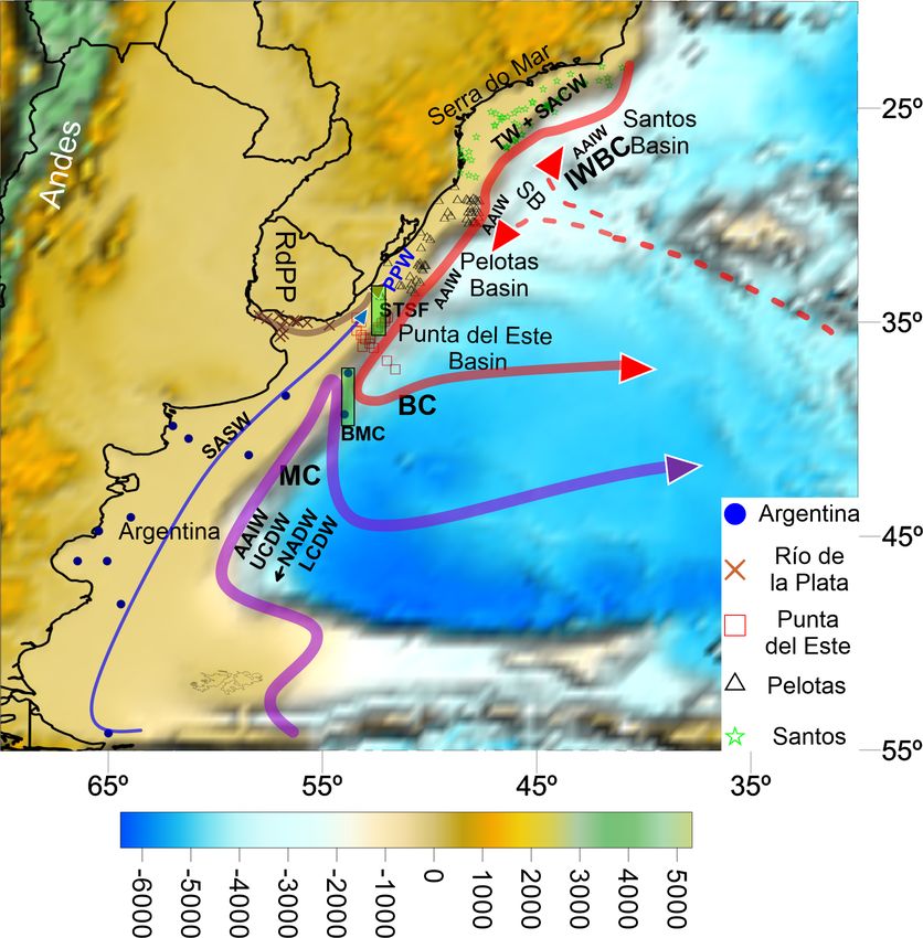
Figure 5. Graphical outputs of the LLC2160 focused on the San- partially, the Santos sector, i.e., to the north of 28◦ S. Con-
tos Bifurcation. (a) The bifurcation is identified as the white zone cerning the SB, there is a clear distinction in isotopic signa-
located around 26◦ S between the 800 and the 1200 m isobath. tures below the 500 m isobath, with less radiogenic Nd pre-
(b) The bifurcation is recognized as the zone of velocities tending vailing to the north of the bifurcation. We thus argue that both
to 0 cm s−1 at 26◦ S–44◦ W. STSF and SB also separate distinct geochemical provinces
on the southwestern Atlantic margin.
The Argentinean and part of the Uruguayan upper margins
development of expressive drainage basins in the area (Ric- are covered by Andean–Patagonian sediments redistributed
comini et al., 2010; Cogné et al., 2011). In this sense, we by the shelf circulation and Malvinas Current. The STSF and
cannot rule out the possibility that a significant part of sed- BMC block the transport of these sediments to the north.
iments that presently cover the shelf and upper slope of the This finding corroborates Hernández-Molina et al. (2016)
Santos Basin originates further north and is transported by and Franco-Fraguas et al. (2016), who defined the northern-
the Brazil Current and derived shelf dynamics (Castro and most limit of a mega-contouritic feature on the Uruguayan
Miranda, 1998; Silveira et al., 2017). slope. Sediments located deeper than the 2000 m isobath
present an Antarctic signature, transported either by the bot-
5.2 Isotope fingerprinting and ocean circulation tom circulation (UCDW and LCDW) or ice-rafted debris.
Sediments from the Río de la Plata estuary advance along
The geochemical fingerprinting approach confirmed the suit- the inner shelf towards southern Brazil, and a mixture of
ability of using Nd and Pb isotopes (except 206 Pb/204 Pb) as Pelotas and Santos signatures are observed between 28 and
reliable proxies for discrimination among the distinct sectors 30◦ S. This mixture is visible in the scatter plot presented in
of the southwestern Atlantic margin. Indeed, the first axis Fig. 4, in which sediments of the Pelotas Basin constitute a
https://doi.org/10.5194/os-17-1213-2021 Ocean Sci., 17, 1213–1229, 20211222 M. M. de Mahiques et al.: Control of oceanic circulation on sediment distribution Figure 6. Graphical outputs of the LLC2160 focused on the Subtropical Shelf Front. (a) Variations of temperature in the zone of the front. (b) Temperature gradient; the front is recognized as the zone of maximum gradient (darker colors). (c) Vertical transect at 35◦ S showing the location of the Subtropical Shelf Front (STSF) as the gradient of the Subantarctic Shelf Water (deep blue) and the Subtropical Shelf Water (light green). mixture of distinct populations, i.e., Santos Basin and Río 6 Conclusions de la Plata. It is essential to highlight the fact that, on in- terannual timescales, the influence of the El Niño–Southern In this paper, we use Nd and Pb radiogenic isotopes to recog- Oscillation (ENSO) in the precipitation regime determines nize the role of ocean circulation in the sediment distribution changes in the freshwater outflow of the RdlP. Cold and of the southwestern Atlantic margin. warm episodes of ENSO cause drought and abundant rain- Andean and continental Patagonian sediments are the fall in Uruguay, southern Brazil, and northeastern Argentina primary source for the deposits of the Argentinean and (Pisciottano et al., 1994; Cazes-Boezio et al., 2003). In addi- Uruguayan shelves, while the lower slope is more influenced tion, changes in the wind patterns during the warm phase of by more distant sources, such as the Antarctic Peninsula. ENSO determine the influence of the PPW towards higher Nevertheless, sediments on the shelf and upper slope are car- latitudes. In conjunction with the Coriolis force, this phe- ried by the flows of the SASW and AAIW, while the UCDW nomenon determines that the PPW follows a NE direction and LCDW transport sediments from the lower slope. close to the shelf break, explaining the distribution up to The Río de la Plata is the primary influencer of the sedi- 28◦ S and, in anomalous years, 25◦ S (Piola et al., 2005). ments off southern Brazil up to the 27◦ S parallel. The sedi- Finally, sediments located northward of 27◦ S originate ments are transported northwards by the PPW, which is trans- from the pre-Cambrian rocks that dominate the coastal do- ported by a wind-driven current. A mixture of sediments mains off SE and E Brazil, being mainly transported by the from the PPW and the north is transported towards the slope intense flow of the BC on the outer shelf and upper slope. between 34 and 28◦ S. Limited input comes from the small rivers that drain the mountainous areas of the Serra do Mar, as previously re- ported by Lourenço et al. (2017) and de Mahiques et al. (2017). Ocean Sci., 17, 1213–1229, 2021 https://doi.org/10.5194/os-17-1213-2021
M. M. de Mahiques et al.: Control of oceanic circulation on sediment distribution                                                     1223

Figure 7. Latitudinal and bathymetric variability of εNd in the      Figure 9. Latitudinal and bathymetric variability of 208 Pb/204 Pb
sector between 23 and 55◦ S. Water masses: Plata Plume Water         in the sector between 23 and 55◦ S. Río de la Plata (RdlP). Wa-
(PPW), Subantarctic Shelf Water (SASW), Tropical Water (TW),         ter masses: Plata Plume Water (PPW), Subantarctic Shelf Wa-
South Atlantic Central Water (SACW), Antarctic Intermediate Wa-      ter (SASW), Tropical Water (TW), South Atlantic Central Water
ter (AAIW), and Lower Circumpolar Deep Water (LCDW). Cur-            (SACW), Antarctic Intermediate Water (AAIW), and Lower Cir-
rents: Malvinas Current (MC) and Brazil Current (BC). Fronts: Sub-   cumpolar Deep Water (LCDW). Currents: Malvinas Current (MC)
tropical Shelf Front (STSW), Brazil–Malvinas Confluence (BMC),       and Brazil Current (BC). Fronts: Subtropical Shelf Front (STSW),
and Santos Bifurcation (SB). Vertical axis in log(10) scale.         Brazil–Malvinas Confluence (BMC), and Santos Bifurcation (SB).
                                                                     Vertical axis in log(10) scale.

                                                                     cal Shelf Front and the Santos Bifurcation, separate distinct
                                                                     geochemical provinces.

                                                                     Data availability. All of the data used in this paper are presented in
                                                                     the Supplement.

                                                                     Supplement. The supplement related to this article is available on-
                                                                     line at: https://doi.org/10.5194/os-17-1213-2021-supplement.

Figure 8. Latitudinal and bathymetric variability of 207 Pb/204 Pb
in the sector between 23 and 55◦ S. Río de la Plata (RdlP). Wa-      Author contributions. MMdM was responsible for conceptualiza-
ter masses: Plata Plume Water (PPW), Subantarctic Shelf Wa-          tion, investigation, writing the original draft, review and editing,
ter (SASW), Tropical Water (TW), South Atlantic Central Water        visualization, and supervision. PFF was responsible for conceptu-
(SACW), Antarctic Intermediate Water (AAIW), and Lower Cir-          alization, investigation, writing the original draft, and review and
cumpolar Deep Water (LCDW). Currents: Malvinas Current (MC)          editing. LB was responsible for conceptualization, investigation,
and Brazil Current (BC). Fronts: Subtropical Shelf Front (STSW),     writing the original draft, and review and editing. RV was respon-
Brazil–Malvinas Confluence (BMC), and Santos Bifurcation (SB).       sible for conceptualization, investigation, writing the original draft,
Vertical axis in log(10) scale.                                      and review and editing. LO was responsible for writing the origi-
                                                                     nal draft, visualization, and review and editing. CBR was respon-
                                                                     sible for investigation, writing the original draft, visualization, and
                                                                     review and editing. RFdS was responsible for investigation, writ-
   Finally, pre-Cambrian rocks are the primary sources of the
                                                                     ing the original draft, and review and editing. BSMK was respon-
sediments deposited further north. They originate from rivers        sible for investigation, writing the original draft, and review and
located northward of the area of study and, on a smaller scale,      editing. RCLF was responsible for supervision, project administra-
by the small drainages that face the ocean in the Serra do Mar       tion, funding acquisition, writing the original draft, and review and
region.                                                              editing. MCB was responsible for supervision, project administra-
   We propose that the main oceanographic boundaries of              tion, funding acquisition, writing the original draft, and review and
the southwestern South Atlantic margin, i.e., the Subtropi-          editing.

https://doi.org/10.5194/os-17-1213-2021                                                             Ocean Sci., 17, 1213–1229, 2021
1224 M. M. de Mahiques et al.: Control of oceanic circulation on sediment distribution
Competing interests. The contact author has declared that neither sediments revisited, Geochim. Cosmochim. Ac., 170, 17–38,
they nor their co-authors have any competing interests. https://doi.org/10.1016/j.gca.2015.08.001, 2015.
Benthien, A. and Müller, P. J.: Anomalously low alkenone tem-
peratures caused by lateral particle and sediment transport in
Disclaimer. Publisher’s note: Copernicus Publications remains the Malvinas Current region, western Argentine Basin, Deep-
neutral with regard to jurisdictional claims in published maps and Sea Res. Pt. I, 47, 2369–2393, https://doi.org/10.1016/s0967-
institutional affiliations. 0637(00)00030-3, 2000.
Beny, F., Bout-Roumazeilles, V., Davies, G. R., Waelbroeck,
C., Bory, A., Tribovillard, N., Delattre, M., and Abra-
Acknowledgements. The authors acknowledge the crew of R/V Al- ham, R.: Radiogenic isotopic and clay mineralogical sig-
pha Crucis and participants of the research cruises Mudbelts I and II natures of terrigenous particles as water-mass tracers:
as well as Talude I and II for helping during the sampling surveys. New insights into South Atlantic deep circulation during
This work is a contribution to the Grupo de Investigación en Cien- the last termination, Quaternary Sci. Rev., 228, 106089,
cia y Tecnología Marina (CINCYTEMA) and to the MOU between https://doi.org/10.1016/j.quascirev.2019.106089, 2020.
the Oceanographic Institute of University of São Paulo (Brazil) Berden, G., Charo, M., Möller, O. O., and Piola, A. R.:
and the Facultad de Ciencias of the Universidad de La Republica Circulation and Hydrography in the Western South At-
(Uruguay), which are institutions to whom the authors are indebted. lantic Shelf and Export to the Deep Adjacent Ocean: 30◦ S
to 40◦ S, J. Geophys. Res.-Oceans, 125, e2020JC016500,
https://doi.org/10.1029/2020jc016500, 2020.
Berkowsky, F.: Variaciones mineralógicas en sedimentos del Río
Financial support. This work was financially supported by the
de la Plata, VII Congreso Geológico Argentino, Neuquén, 9–15
São Paulo Science Foundation (FAPESP) by grants 2010/06147-
April 2021, Asociación Geológica Argentina, 649–658, 1978.
5, 2014/08266-2, 2015/17763-2, 2016/22194-0, and 2019/00256-1.
Berkowsky, F.: Arenas del Río de la Plata: una excepción a la
In addition, Michel Michaelovitch de Mahiques acknowledges the
relación entre composición de areniscas y la tectónica de pla-
Brazilian Council of Scientific Research (CNPq) for research grant
cas, Primera Reunión Argentina de Sedimentología, La Plata,
300962/2018-5.
Argentina, 6–10 October 1986, Asociación Argentina de Sedi-
mentología, 263–266, 1986.
Biló, T. C., da Silveira, I. C. A., Belo, W. C., de Castro, B.
Review statement. This paper was edited by Arvind Singh and re- M., and Piola, A. R.: Methods for estimating the veloci-
viewed by Yunchao Shu and two anonymous referees. ties of the Brazil Current in the pre-salt reservoir area off
southeast Brazil (23◦ S–26◦ S), Ocean Dynam., 64, 1431–1446,
https://doi.org/10.1007/s10236-014-0761-2, 2014.
Blanchet, C. L.: A database of marine and terrestrial radiogenic
Nd and Sr isotopes for tracing earth-surface processes, Earth
References Syst. Sci. Data, 11, 741–759, https://doi.org/10.5194/essd-11-
741-2019, 2019.
Baptista, M. S. and Conti, L. A.: The Staircase Structure of the Boebel, O., Schmid, C., and Zenk, W.: Flow and recir-
Southern Brazilian Continental Shelf, Mathematical Problems in culation of Antarctic Intermediate Water across the Rio
Engineering, 2009, 1–17, https://doi.org/10.1155/2009/624861, Grande Rise, J. Geophys. Res.-Oceans, 102, 20967–20986,
2009. https://doi.org/10.1029/97jc00977, 1997.
Barreto, C. J. S., Lafon, J. M., de Lima, E. F., and Sommer, C. Boebel, O., Davis, R. E., Ollitrault, M., Peterson, R. G., Richard-
A.: Geochemical and Sr–Nd–Pb isotopic insight into the low- son, P. L., Schmid, C., and Zenk, W.: The intermediate depth
Ti basalts from southern Paraná Igneous Province, Brazil: the circulation of the western South Atlantic, Geophys. Res. Lett.,
role of crustal contamination, Int. Geol. Rev., 58, 1324–1349, 26, 3329–3332, https://doi.org/10.1029/1999gl002355, 1999a.
https://doi.org/10.1080/00206814.2016.1147988, 2016. Boebel, O., Schmid, C., and Zenk, W.: Kinematic ele-
Basile, I., Grousset, F. E., Revel, M., Petit, J. R., Biscaye, P. E., and ments of Antarctic Intermediate Water in the west-
Barkov, N. I.: Patagonian origin of glacial dust deposited in East ern South Atlantic, Deep-Sea Res. Pt. II, 46, 355–392,
Antarctica (Vostok and Dome C), during glacial stages 2, 4 and https://doi.org/10.1016/s0967-0645(98)00104-0, 1999b.
6, Earth Planet. Sc. Lett., 146, 573–589, 1997. Bozzano, G., Violante, R. A., and Cerredo, M. E.: Mid-
Bassetto, M., Alkmim, F. F., Szatmari, P., and Mohriak, W. U.: dle slope contourite deposits and associated sedimentary
The oceanic segment of the southern Brazilian margin: Morpho- facies off NE Argentina, Geo-Mar. Lett., 31, 495–507,
structural domains and their tectonic significance, in: Atlantic https://doi.org/10.1007/s00367-011-0239-x, 2011.
Rifts and Continental Margins, edited by: Mohriak, W. and Tai- Bozzano, G., Martín, J., Spoltore, D. V., and Violante, R. A.: Los
wani, M., Geophysical Monograph Series, American Geophysi- cañones submarinos del margen continental Argentino: una sín-
cal Union, 235–259, 2000. tesis sobre su génesis y dinámica sedimentaria, Latin American
Bayon, G., Toucanne, S., Skonieczny, C., André, L., Bermell, S., Journal of Sedimentology and Basin Analysis, 24, 85–101, 2017.
Cheron, S., Dennielou, B., Etoubleau, J., Freslon, N., Gauch- Bozzano, G., Cerredo, M. E., Remesal, M., Steinmann, L., Haneb-
ery, T., Germain, Y., Jorry, S. J., Ménot, G., Monin, L., Ponzev- uth, T. J. J., Schwenk, T., Baqués, M., Hebbeln, D., Spoltore,
era, E., Rouget, M. L., Tachikawa, K., and Barrat, J. A.: D., Silvestri, O., Acevedo, R. D., Spiess, V., Violante, R. A.,
Rare earth elements and neodymium isotopes in world river
Ocean Sci., 17, 1213–1229, 2021 https://doi.org/10.5194/os-17-1213-2021M. M. de Mahiques et al.: Control of oceanic circulation on sediment distribution 1225 and Kasten, S.: Dropstones in the Mar del Plata Canyon Area DePaolo, D. J.: Neodymium isotopes in the Colorado Front Range (SW Atlantic): Evidence for Provenance, Transport, Distribution, and crust–mantle evolution in the Proterozoic, Nature, 291, 193– and Oceanographic Implications, Geochem. Geophy. Geosy., 22, 196, https://doi.org/10.1038/291193a0, 1981. e2020GC009333, https://doi.org/10.1029/2020gc009333, 2021. Depetris, P. J. and Griffin, J. J.: Suspended Load in the Rio Burone, L., Franco-Fraguas, P., de Mahiques, M. M., and Or- De La Plata Drainage Basin, Sedimentology, 11, 53–60, tega, L.: Geomorphological and Sedimentological Characteri- https://doi.org/10.1111/j.1365-3091.1968.tb00840.x, 1968. zation of the Uruguayan Continental Margin: A Review and Duarte, C. S. L. and Viana, A. R.: Santos Drift System: strati- State of Art, Journal of Sedimentary Environments, 3, 253–264, graphic organization and implications for late Cenozoic palaeo- https://doi.org/10.12957/jse.2018.39150, 2018. circulation in the Santos Basin, SW Atlantic Ocean, Geo- Campos, E. J. D., Mulkherjee, S., Piola, A. R., and de Carvalho, F. logical Society, London, Special Publications, 276, 171–198, M. S.: A note on a mineralogical analysis of the sediments associ- https://doi.org/10.1144/gsl.sp.2007.276.01.09, 2007. ated with the Plata River and Patos Lagoon outflows, Cont. Shelf Emilsson, I.: The shelf and coastal waters off southern Res., 28, 1687–1691, https://doi.org/10.1016/j.csr.2008.03.014, Brazil, Boletim do Instituto Oceanográfico, 11, 101–112, 2008. https://doi.org/10.1590/S0373-55241961000100004, 1961. Carranza, A., Recio, A. M., Kitahara, M., Scarabino, F., Or- Etchichury, M. C. and Remiro, J. R.: Muestras de fondo de la tega, L., López, G., Franco-Fraguas, P., De Mello, C., plataforma continental comprendida entre los paralelos 34◦ y Acosta, J., and Fontan, A.: Deep-water coral reefs from the 36◦ 30 de latitud sur y los meridianos 53◦ 10 y 56◦ 30 de lon- Uruguayan outer shelf and slope, Marine Biodivers., 42, 411– gitud oeste, Revista del Museo Argentino de Ciencias Naturales 414, https://doi.org/10.1007/s12526-012-0115-6, 2012. Bernardino Rivadavia, VI, 1–70, 1960. Castro, B. M. and Miranda, L. B.: Physical Oceanography of the Etchichury, M. C. and Remiro, J. R.: La corriente de Malvinas y los Western Atlantic continental shelf located between 4N and 34S, sedimentos pampeanopatagónicos, Revista del Museo Argentino in: The Sea, edited by: Robinson, A. R. and Brink, K. H., John de Ciencias Naturales Bernardino Rivadavia, 1, 1–11, 1963. Wiley & Sons, New York, 210–251, 1998. Fernandes, A. M., da Silveira, I. C. A., Calado, L., Campos, E. Cazes-Boezio, G., Robertson, A. W., and Mechoso, C. R.: J. D., and Paiva, A. M.: A two-layer approximation to the Seasonal Dependence of ENSO Teleconnections over South Brazil Current–Intermediate Western Boundary Current Sys- America and Relationships with Precipitation in Uruguay, tem between 20◦ S and 28◦ S, Ocean Model., 29, 154–158, J. Climate, 16, 1159–1176, https://doi.org/10.1175/1520- https://doi.org/10.1016/j.ocemod.2009.03.008, 2009. 0442(2003)162.0.Co;2, 2003. Figueiredo, A. G. and Madureira, L. S. P.: Topografia, composição, Chen, S., Qiu, B., Klein, P., Wang, J., Torres, H., Fu, L.-L., and refletividade do substrato marinho e identificação de provín- Menemenlis, D.: Seasonality in Transition Scale from Balanced cias sedimentares na Regiao Sudeste-Sul do Brasil, Série Doc- to Unbalanced Motions in the World Ocean, J. Phys. Oceanogr., umentos Técnicos do Programa REVIZEE Score Sul, Instituto 48, 591–605, https://doi.org/10.1175/jpo-d-17-0169.1, 2018. Oceanográfico – USP, São Paulo, 64 pp., 2004. Cogné, N., Gallagher, K., and Cobbold, P. R.: Post-rift reactivation Framiñan, M. B. and Brown, O. B.: Study of the Río de la of the onshore margin of southeast Brazil: Evidence from apatite Plata turbidity front, Part 1: spatial and temporal distribution, (U–Th)/He and fission-track data, Earth Planet. Sc. Lett., 309, Cont. Shelf Res., 16, 1259–1282, https://doi.org/10.1016/0278- 118–130, https://doi.org/10.1016/j.epsl.2011.06.025, 2011. 4343(95)00071-2, 1996. Corrêa, I. C. S.: Les variations du niveau de la mer durant les Franco-Fraguas, P., Burone, L., Mahiques, M., Ortega, L., Urien, derniers 17.500 ans BP: l’exemple de la plate-forme continen- C., Muñoz, A., López, G., Marin, Y., Carranza, A., Lahuerta, tale du Rio Grande do Sul-Brésil, Mar. Geol., 130, 163–178, N., and de Mello, C.: Hydrodynamic and geomorpholog- https://doi.org/10.1016/0025-3227(95)00126-3, 1996. ical controls on surface sedimentation at the Subtropical de Mahiques, M. M., Tassinari, C. C. G., Marcolini, S., Vi- Shelf Front/Brazil–Malvinas Confluence transition off Uruguay olante, R. A., Figueira, R. C. L., Silveira, I. C. A., Burone, (Southwestern Atlantic Continental Margin), Mar. Geol., 349, L., and Sousa, S. H. M.: Nd and Pb isotope signatures on the 24–36, https://doi.org/10.1016/j.margeo.2013.12.010, 2014. Southeastern South American upper margin: Implications for Franco-Fraguas, P., Burone, L., Mahiques, M., Ortega, L., sediment transport and source rocks, Mar. Geol., 250, 51–63, and Carranza, A.: Modern sedimentary dynamics in https://doi.org/10.1016/j.margeo.2007.11.007, 2008. the Southwestern Atlantic Contouritic Depositional Sys- de Mahiques, M. M., Hanebuth, T. J. J., Nagai, R. H., Bícego, M. C., tem: New insights from the Uruguayan margin based Figueira, R. C. L., Sousa, S. H. M., Burone, L., Franco-Fraguas, on a geochemical approach, Mar. Geol., 376, 15–25, P., Taniguchi, S., Salaroli, A. B., Dias, G. P., Prates, D. M., and https://doi.org/10.1016/j.margeo.2016.03.008, 2016. Freitas, M. E. F.: Inorganic and organic geochemical fingerprint- Franco-Fraguas, P., Burone, L., Goso, C., Scarabino, F., Muzio, ing of sediment sources and ocean circulation on a complex con- R., Carranza, A., Ortega, L., Muñoz, A., and Mahiques, M.: tinental margin (São Paulo Bight, Brazil), Ocean Sci., 13, 209– Sedimentary processes in the head of the Cabo Polonio mega 222, https://doi.org/10.5194/os-13-209-2017, 2017. slide canyon (Southwestern Atlantic margin off Uruguay), Latin de Mahiques, M. M., Figueira, R. C. L., Sousa, S. H. d. M., San- American Journal of Sedimentology and Basin Analysis, 24, 31– tos, R. F. d., Ferreira, P. A. d. L., Kim, B. S. M., Cazzoli y 44, 2017. Goya, S., de Matos, M. C. S. N., and Bícego, M. C.: Sedimenta- Frenz, M., Höppner, R., Stuut, J.-B., Wagner, T., and Henrich, R.: tion on the southern Brazilian shelf mud depocenters: Insights Surface sediment bulk geochemistry and grain-size composition on potential source areas, J. S. Am. Earth Sci., 100, 102577, related to the oceanic circulation along the South American con- https://doi.org/10.1016/j.jsames.2020.102577, 2020. tinental margin in the Southwest Atlantic, in: The South Atlantic https://doi.org/10.5194/os-17-1213-2021 Ocean Sci., 17, 1213–1229, 2021
You can also read