A- Far North District Council
←
→
Page content transcription
If your browser does not render page correctly, please read the page content below
.

            a-
.

    *013*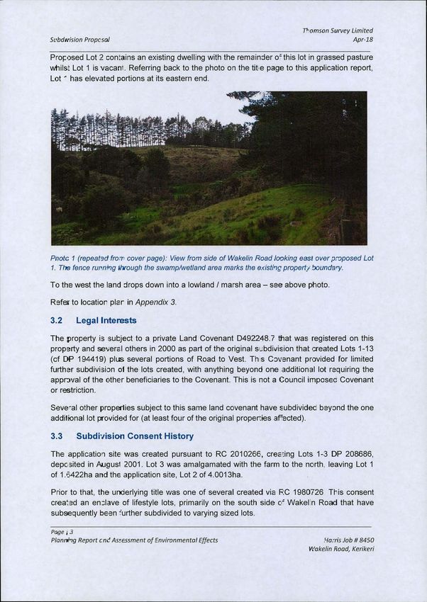
918056 3
                                                 TI-22bN
                                                      SURVE
                                                            LIMITED Kerlkerl Service Centri

                                                                                                              0 4 APR 2018

            Our reference: 8450.1(FNDC)

            4 April 2018

            Resource Consents Department
            Far North District Council                                  i;*35
                                                                    40%1.
            JB Centre                               %//92,-: 2
            Kerikeri Road                                           k' i; {J//2-
                                                    t. 4434%

            RE: lan Harris, Subdivision, Wakelin Road, Kerikeri

            Please find enclosed application for resource consent to subdivide land at 149 Wakelin
            Road, Kerikeri to create one additional lot in the Rural Production Zone.

            An Application Form is attached, along with Billpayer details. The application fee of
            $1,817 has been paid by Direct Credit to the Council's ASB account number:
            12-3244-0022509-00, referenced "RC Fee Harris".

            The applicant owns a dog. Please contact the applicant in advance of any site visit.

            If you have any queries please contact the writer.
                                                                                                b.f -3 44*

            Yours sincerely

            Lyn(dy Newport
            Senior Planner

            THOMSON SURVEY

315 Kerikeri Road, Kerikeri                                                              Telephone: 09 4077360
P.O. Box 372, Kerikeri 0245, New Zealand.                                                 Facsimile:         094077322

Email: Kerikeri@tsurvey.co.nz                                              After Hours:Director: Denis Thomson 09 4071372

denis@tsurvey.co.nz, david@tsurvey.co.nz                                    After   Hours:Planner: David Stringer 09 4076532

             Background picture represents a New Zealand surveying trig station, used to beacon control survey marks
Form 9

                      APPLICATION FOR RESOURCE CONSENT

                                    Sections 87AAC, 88 & 145
                                 Resource Management Act 1991

To Far North District Council

1. I, Ian Harris of

           149 Wakelin Road,
           R D 3 Kerikeri

           0293

           apply for subdivision consent.

2. The activity to which the application relates (the proposed activity) is as follows:

           Subdivision to create one additional lot in the Rural Production Zone, as a non
           complying activity.

3. The site at which the proposed activity is to occur is as follows:

           149 Wakelin Road, Kerikeri
           Legally Described as: Lot 2 DP 208686
           CFR: NA136D/720

           A description of the natural and physical characteristics and any adjacent uses that
           may be relevant is contained in the accompanying supporting documentation.

4. The names and address of the owner and/or occupier of the land to which the
           application relates are as follows:

           As above

5. There are no other activities that are part of the proposal to which this application
           relates.

6. No additional resource consents (other than those listed above) are needed for the
           proposal to which this application relates.

7. / attach an assessment of the proposed activity's effect on the environment that

Page / 1
Form 9                                                                           Harris; Job # 8450

                                                                               Wakelin Road, Kerikeri
(a) Includes the information required by Clause 6 of Schedule 4, and
           (b) Addresses the matters specified in Clause 7 of Schedule 4; and
           (c) Includes such detail as corresponds with the scale and significance of the effects
                that the activity may have on the environment.

 8. / attach an assessment of the proposed activity against the matters set out in
           Part 2 of the Act.

 9. I attach an assessment of the proposed activity against any relevant provisions of a
          document referred to in Section 104(1)(b) of the Act, including the information
           required by Clause 2(2) of Schedule 4 of the Act.

 10.       Matters specific to subdivision:
           I attach information that adequately defines the following:
           . The position of all new boundaries;
           . The areas of each allotment;

           No new reserves to be created;
           No existing esplanade reserves, esplanade strips or access strips;
           No parts of the bed of a river or lake to be vested in the territorial authority under
           Section 237A of the Act;
           No land within the Coastal Marine Area (which is to become part of the common
           marine and coastal area under Section 237A of the Act); and No land to be set
           aside as new roads.

Lynley Newport
 Thomson Survey Ltd
On behalf of Ian Harris

           1-4-/8
Date.......................···

Address for Service of applicant:

Lynley Newport
Thomson Survey Ltd
P O Box 372

Kerikeri 0245

page / 2

Form 9
                                                                                 Harris; Job # 8450
                                                                               Wakelin Road, Kerikeri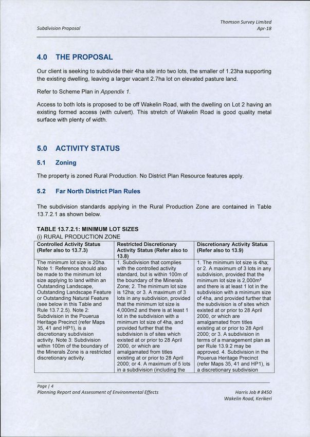
09 407 7360 Mobile:021 257 3892 Email:
               lynley@tsurvey. co.nz

      Excerpt from FNDC Application Form recording Bill Payer Details is attached.
     Client Authorisation:

     1/we .....Uk...j'AC.C.'66161>...B:g>.al
                                                              authorise Thompson §MN@irt,tdto
     act as my/our agent for the purposes of lodging this resource consent.

                                                                  3 -4-
Thomson Survey Limited
Subdivision Proposal                                                                     Apr-18

                                         lan Harris

                       PROPOSED SUBDIVISION

                       149 Wakelin Road, Kerikeri

                             PLANNER'S REPORT &

      ASSESSMENT OF ENVIRONMENTAL EFFECTS

                                    Thomson Survey Ltd
                                               Kerikeri

1.0        INTRODUCTION

1.1        The Proposal

Our client, lan Harris, proposes to subdivide property in the Rural Production Zone to create
one additional lot.

The property has access off Wakelin Road and has an area of just over 4ha.

Page I 1
Planning Report and Assessment of Environmental Effects                        Harris Job # 8450

                                                                          Wakelin Road, Kerikeri
Thomson Survey Limited
Subdivision Proposal                                                                      Apr-18

Refer to Scheme Plan attached in Appendix 1.

1.2        Scope of this Report

This assessment and report accompanies the Resource Consent Application made by our
client, and is provided in accordance with Section 88 and Schedule 4 of the Resource
Management Act 1991.

The application seeks consent to subdivide land in the Rural Production Zone, as a non
complying activity. The information provided in this assessment and report is considered
commensurate with the scale and intensity of the activity for which consent is being sought,
and covers:

      • A description of the proposal;
      • A description of the site and its environs;
      • A description of the history of the site and environs;
      • An assessment of environmental effects;

      • An assessment of the proposal against relevant objectives and policies of the Far
           North District Plan;

      • An assessment of the proposal against relevant provisions of Part 2 of the Act and
           other National and Regional Standards, Policies and Plans;
      • Record of consultation.

2.0        SUMMARY DESCRIPTION OF PROPOSAL

Location:                                 149 Wakelin Road, Kerikeri.

Legal description & CFR:                  Lot 2 DP 208686, contained in CFR NA136D/720 (copy
                                          attached as     Appendix 21

Zoning:                                   Rural Production

3.0 SITE DESCRIPTION

3.1        Physical characteristics

The application site is 4.0013ha in area, and is accessed off Wakelin Road (20m metal
surface), at the State Highway 10 end (at the base of Bulls Gorge). The site is on the north
side of Wakelin Road.

The land is predominantly in pasture, with vegetation along the road boundary (pine trees)
and along the proposed new lot boundary.

Page 1 2
Planning Report and Assessment of Environmental Effects                         Harris Job # 8450

                                                                           Wakelin Road, Kerikeri
Thomson Survey Limited
Subdnfision Propcsol                                                                             Apr-18

Proposed Lot 2 con:ains an existing dwelling with the remainder o= this lot in grassed pasture
whils: Lot 1 is vacan-. Referring back to the photo on the tit.e page to this application report,
Lot ' has elevated portions at its eastern end.

                                                                  A.

Pnote 1 (repeated fron- cover page): View from side of Wakelin Road looking east over proposed Lot
1. The fence runnirlg ihrough the swamp/wetland area marks the existive propert./ boundary.

To the west the land drops down into a lowland / marsh area - see above photo.

Refer to locatior pler in Appendix 3.

3.2 Legal Interests

The property is sutject to a private Land Covenant D492248.7 that was registered on this
property and several others in 2000 as part of the original subdivision that created Lots 1-13
(cf DP 1 94419) plus several portions of Road to Vest. Th s Covenant provided for limited
further subdivision 01 the lots created, with anything beyond one additional lot requiring the
apprival of the other beneficiaries to the Covenant. This is not a Council imposec Covenant
or restriction.

Seve-al other properlies subject to this same land covenant have subdividec beyond the one
additional lot provided for (at least four of the original proper:ies afected),

3.3        Subdivision Consent History

The application site was created pursuant to RC 2010266, creating Lots 1-3 DP 208686,
deposited in Augusl 2001. Lot 3 was amalgamated with the farm to the north leaving Lot 1
of 1.6422ha and the application site, Lot 2 of 4.0013ha.

Prior to that, the uncerlying title was one of several created via RC 1980726 This consent
created an en]Iave of lifestyle lots, primarily on the south side of Wakel n Road that have
subsequently been further subdivided to varying sized lots.

page i 3

Plannhg Report ent As:essment of Environmental Effects                                 Harris Job # 8450

                                                                                  Wakelin Road, Kerikeri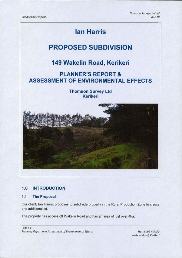
Thomson Survey Limited
Subdivision Proposal                                                                                   Apr-18

4.0 THE PROPOSAL

Our client is seeking to subdivide their 4ha site into two lots, the smaller of 1.23ha supporting
the existing dwelling, leaving a larger vacant 2.7ha lot on elevated pasture land.

Refer to Scheme Plan in         Appendix 1.

Access to both lots is proposed to be off Wakelin Road, with the dwelling on Lot 2 having an
existing formed access (with culvert). This stretch of Wakelin Road is good quality metal
surface with plenty of width.

5.0 ACTIVITY STATUS

5.1       Zoning

The property is zoned Rural Production. No District Plan Resource features apply.

5.2 Far North District Plan Rules

The subdivision standards applying in the Rural Production Zone are contained in Table
13.7.2.1 as shown below.

TABLE 13.7.2.1: MINIMUM LOT SIZES

(i) RURAL PRODUCTION ZONE
Controlled Activity Status            Restricted Discretionary            Discretionary Activity Status
(Refer also to 13.7.3)                Activity Status (Refer also to      (Refer also to 13.9)
                                      13.8)
The minimum lot size is 20ha.         1. Subdivision that complies        1. The minimum lot size is 4ha;
Note 1: Reference should also         with the controlled activity        or 2. A maximum of 3 lots in any
be made to the minimum lot            standard, but is within 100m of     subdivision, provided that the
size applying to land within an       the boundary of the Minerals        minimum lot size is 2,000rr12
Outstanding Landscape,                Zone; 2. The minimum lot size       and there is at least 1 lot in the

Outstanding Landscape Feature is 12ha; or 3. A maximum of 3               subdivision with a minimum size

or Outstanding Natural Feature        lots in any subdivision, provided   of 4ha, and provided further that
(see below in this Table and          that the minimum lot size is        the subdivision is of sites which

Rule 13.7.2.5). Note 2:               4,000m2 and there is at least 1     existed at or prior to 28 April
Subdivision in the Pouerua            lot in the subdivision with a       2000, or which are
Heritage Precinct (refer Maps         minimum lot size of 4ha, and        amalgamated from titles
35,41 and HP1), is a                  provided further that the           existing at or prior to 28 April
discretionary subdivision             subdivision is of sites which       2000; or 3. A subdivision in
activity. Note 3: Subdivision         existed at or prior to 28 April     terms of a management plan as
within 100m of the boundary of        2000, or which are                  per Rule 13.9.2 may be
the Minerals Zone is a restricted amalgamated from titles                 approved. 4. Subdivision in the
discretionary activity.               existing at or prior to 28 April    Pouerua Heritage Precinct
                                      2000; or 4. A maximum of 5 lots     (refer Maps 35, 41 and HP1), is
                                      in a subdivision (including the     a discretionary subdivision

Page 14

Planning Report and Assessment of Environmental Effects                                     Harris Job # 8450

                                                                                       Wakelin Road, Kerikeri
Thomson Survey Limited
Subdivision Proposal                                                                                  Apr-18

                                    parent lot) where the minimum       activity. Note 1: There is no
                                    size of the lots is 2ha, and        restriction on the number of 4ha
                                    where the subdivision is created    lots in a subdivision (clause 1).
                                    from a site that existed at or      Note 2: The effect of the rule

                                    prior to 28 April 2000; 5. Rules    under clause 2 is that there is a

                                    under clauses 3 and 4 provide       once-off opportunity to
                                    two alternative options for the     subdivide a maximum of two

                                    creation of a specified number      small lots from a site existing at
                                    of small lots from sites existing   28 April 2000. Subdivision of
                                    at 28 April 2000. Where an          small lots which does not meet

                                    application under one of these      this rule is a noncomplying
                                    clauses takes up only part of       activity unless the lots are part
                                    the total allowance, a              of a Management Plan
                                    subsequent application to take      application.
                                    up the remainder of that
                                    particular allowance may be
                                    considered by Council,
                                    notwithstanding that the
                                    subsequent application involves
                                    a lot which no longer meets the
                                    existing at 28 April 2000
                                    criterion.

The Title is dated August 2001. There are no identifiable residual subdivision rights. Given
this, and the proposed lot sizes, the proposal is a non complying activity.

6.0 ASSESSMENT OF ENVIRONMENTAL EFFECTS

The district plan lists a number of matters in Section 13.10 Assessment Criteria that should
be considered when assessing the effects of a proposed subdivision. These are addressed
below.

6.1        Allotment sizes and dimensions (including amenity and character
           effects)

Lot 2 is already developed, supporting an existing dwelling with crossing to Wakelin Road.
This has a nice outlook with ample scope for the existing residential and small lifestyle land
use.

Lot 1 is proposed to be 2.7ha in area. It can accommodate the required 30m x 30m buildable
area, whilst still meeting the 1 Om boundary setback requirement applying in the zone, on all
boundaries. There is adequate elevated land on the site to support residential use.

The proposed lot sizes and dimensions are considered wholly appropriate for their existing
and intended use.

Page 1 5
Planning Report and Assessment Of Environmental Effects                                     Harris Job # 8450

                                                                                       Wakelin Road, Kerikeri
Thomson Survey Limited Subdivision Proposal Apr-18 6.2 Property Access There is an existing formed crossing (with culvert) to 149 Wakelin Road. Proposed vacant Lot 1 has a long road frontage anc for the most oart the road is below the site. There is a bank rising up from the road along which a single row of pine trees is growing. Photo 2: Wai
Thomson Survey Limited
Subdivision Proposal                                                                        Apr-18

There is no posted speed restriction on Wakelin Road, however being metal surface the
operating speed is substantially short of 100kph, and more likely in the 70-75kph range. This
would require a 95m sight distance in order to be compliant with FNDC/S/6.

This is achievable at a location in the vicinity of that shown on the scheme plan, with
potential for some treatment of the roadside bank and pine trees in order to improve the
visibility.

6.3        Natural and Other Hazards

There are no natural hazards identified for the sites. The site is not identified in the Regional
Council on-line maps as being susceptible to either flood or erosion.

6.4        Water Supply

Water supply for the existing dwelling is via roof catchment. For a future dwelling on the
vacant lot, water supply will be via roof catchment into tanks. An appropriate consent notice
can be applied by the Council to ensure any future dwellings on the lots have sufficient water
supply for both potable and fire fighting purposes.

6.5        Stormwater Disposal

A Site, Soil & Stormwater Evaluation and Report has been carried out for the proposed
subdivision, by Gerry White of Bay of Islands Plumbing and Drainage Ltd (Registered
Drainlayer). This is attached as Appendix 4.

Section 11 of the above referenced report refers. The findings are summarised as:

"Stormwater / roofwater catchment can be collected via storage vessels with the overflows
disposed of effectively and appropriately towards the natural surface water flow paths".

"These lots are physically large enough to adequately dispose of stormwater from future
building platform/hardstand areas without the need for any attenuation / retention ponds or
vessels".

The existing dwelling with driveway on proposed Lot 2 has existing stormwater management
mechanisms in place and the impermeable surface coverage will be less than 15% of the
new lot area of 1.23ha.

6.6        Sanitary Sewage Disposal

A Site, Soil & Stormwater Evaluation and Report has been carried out for the proposed
subdivision, by Gerry White of Bay of Islands Plumbing and Drainage Ltd (Registered
Drainlayer). This is attached as Appendix 4.

It concludes that on-site wastewater treatment and disposal is achievable for the proposed
vacant lot, by way of secondary treatment via domestic aeration system or similar, with final
application to ground via compensating trickle irrigation.

Page 1 7
Planning Report and Assessment Of Environmental Effects                           Harris Job # 8450

                                                                             Wakelin Road, Kerikeri
Thomson Survey Limited
Subdivision Proposal Apr-18
The existing dwelling within proposed Lot 2 has an existing on site waste water system in
place. Given the house location at the extreme eastern end of Lot 2, there is no likelihood of
any disposal area going beyond the proposed boundary into Lot 1.
6.7 Energy Supply & Telecommunications
The existing residential dwelling has existing services. Being a rural subdivision, there is no
requirement for power or telephone services and the Council can impose its standard
consent notice in this regard, advising future lot owner of Lot 1 that provision of power and
telecommunications to the lot boundary was not a condition of consent.
Consultation with Top Energy and Chorus was nonetheless undertaken - refer Appendix 5.
Both power and telecommunication services are available for a future lot owner.
6.8 Easements for any purpose
There are no existing easements and no new easements are proposed.
6.9 Preservation and enhancement of heritage resources, vegetation, fauna
and landscape, and land set aside for conservation purposes
There are no identified Sites of Significance to Maori, no recorded or registered
archaeological sites, and no Scheduled heritage resource as listed in the District Plan
affecting the property.
The property sits to the north of Wakelin Road. This road forms the 'boundary' between what
is noted as a high density kiwi area (south side of road); and kiwi present area (north side of
area).
The application site contains no kiwi habitat itself, being predominantly in pasture apart from
the lowland area on proposed Lot 1, this latter area more likely to support bird species
associated with swamp / wetland habitat, than kiwi. There are no areas of significant
indigenous vegetation or habitat of indigenous fauna within the actual site.
There is no existing restriction of any kind on the application site in regard to kiwi protection
and the applicant owns a dog.
However, in recognition of the potential for kiwi to be present within the wider area, the
applicant is prepared to accept restrictions/controls on dog and cat ownership. Something
along the following lines would be acceptable:
"No more than 2 dogs and 1 cat shall be introduced or kept on the lot at any time. Any dog
must be micro-chipped and have a kiwi aversion trained certification. Any dog must be kept
within a dog-proof fenced area on the lot and be under effective control at all times when
outside of the fenced area, e.g. on a lead. At night any dog must be kept inside or be tied up.
Any cat is to be neutered, preferably micro chipped and kept inside at night. No mustelids
shall be introduced or kept on the property".
Page 1 8
Planning Report and Assessment of Environmental Effects Harris Job # 8450
Wakelin Road, KerikeriThomson Survey Limited
Subdivision Proposal Apr-18
There are no landscape values identified as applying to the site or general area and no land
set aside for conservation purposes.
6.10 Land use compatibility (reverse sensitivity)
The subdivision creates one additional lifestyle property in an area already supporting a
number of similar properties (12-14 existing life style lots within a kilometre stretch of
Wakelin Road).
This enclave of lifestyle properties is set amongst a rural area dominated by farmland, with a
bush area reserve further to the west on the far side of Bulls Gorge, and pine forest as you
travel east.
The application site itself is bounded by a lifestyle lot to the west and pasture behind it to the
north. My observation of the farm land is that it is in extensive beef farming use and forestry.
In summary, I do not believe that the addition of one more lifestyle lot in this location will
significantly add to or worsen the risk of reverse sensitivity issues arising.
6.11 Access to waterbodies
There is a low lying swampy area in the southwestern corner of Lot 1, close to the road. This
is not regarded as a significant wetland and is not a waterbody to which public access
should be provided.
6.12 Building Locations (and effect on amenity and character, and the
relationship between open space and built environment)
The proposed vacant lot can readily accommodate a residential unit, within the area of
elevated ground, generally identified in the Site Soil & Stormwater Evaluation in Appendix 4.
Should the pine trees remain within road reserve, the house site will be barely visible from
any sites across Wakelin Road. It will be visible from Wakelin Road when travelling east, but
only briefly, before being screened by the pine trees and the bank itself.
There are a number of residential dwellings in the general area and because of the lay of the
land and intervening vegetation, an attractive open space / built environment ratio is
maintained without adverse effect on amenity and character.
The proposal consolidates development within an existing area of low density housing in a
larger rural setting, as opposed to spreading or extending that development. This is seen as
a positive effect in regard to maintaining amenity and character values rather than a negative
one.
The visual catchment is relatively restricted to the enclave of existing lots, and the addition of
a dwelling on proposed Lot 1 will be in keeping with this existing amenity and character and,
in my opinion, will not adversely impact on that existing amenity and character.
Page 1 9
Planning Report and Assessment Of Environmental Effects Harris Job # 8450
Wakelin Road, KerikeriThomson Survey Limited
Subdivision Proposal Apr-18
6.13 Proximity to Airports
The property is not within any airport buffer area.
6.14 Effect of Earthworks and Utilities
The only earthworks necessitated by the subdivision itself is the construction of access
crossing to the vacant lot. This will require excavation works, largely within road reserve, and
the installation of an appropriately sized culvert. The work will be done to a standard
required by Council's conditions of consent with the appropriate sediment and erosion
control measures in place.
6.14 Soil
The site does not contain "highly versatile" soils and is in pasture with some regenerating
gorse and scrub. The land is already of a size too small for anything other than lifestyle
grazing and is not suitable for cropping. The subdivision does little to change that scenario
other than where there is currently only one lifestyle lot, there will be two.
I do not believe that this adversely impacts on the life supporting capacity of soil.
6.15 Other Matters
The proposal does not involve any hazardous installations. There is no discharge of
contaminant resulting from the subdivision.
It is considered that the subdivision does not give rise to any adverse environmental effects
that require ongoing monitoring of any activities.
The application site is not subject to any customary marine title or protected customary right.
Precedent Effects
This enclave of rural lifestyle lots (now numbering some 14 properties in the immediate
vicinity, with a further 8 slightly further afield but from same parent property) has evolved
since the original subdivision in 1998. Several of the original lots have taken the opportunity
to further subdivide such that where there were previously 9 properties subdivided off the
original property, there are now 22.
Some of these subdivisions have been restricted discretionary or discretionary activity
subdivisions, others have been non complying.
Some (at least four) have gone beyond the restrictions of the private Land Covenant and
taken more than one further lot from the original lot.
In addition, elsewhere in this zone, where there have been other non complying subdivision
applications and where the applicant has been able to satisfy the gateway tests of 104D and
Page I 10
Planning Report and Assessment Of Environmental Effects Harris Job # 8450
Wakelin Road, KerikeriThomson Survey Limited
Subdivision Proposal Apr-18
show that the subdivision is a sustainable use for the land, the Council has granted consent
to similar size lots.
I believe that the Council has already set a precedent for a subdivision such as this one
being proposed. This has not been a negative precedent and, in my opinion, has not
threatened the integrity of the plan. 1 believe this current proposal is consistent with other
subdivisions in this same area and that the Council can grant consent.
Cumulative Effects
As stated above, what started as 9 lifestyle lots has now changed to 22, most of which are
built on.
Appendix 7 contains aerial photographs (Source Far North Maps, 2009; and Google imagery
of more recent vintage). These show the settlement pattern of subdivision of the original
property in 1998. The result has been a 'clustering' of lifestyle lots in a wider rural setting,
and the proposed subdivision that is the subject of this application, is within that same
cluster. It will not see an 'extension' or 'expansion' of built development, but rather an 'infill'
or consolidation of built development, in keeping with the existing amenity and character of
the area. 1 believe it is preferable to consolidate within an existing area than to spread
subdivision out.
I believe that the subdivision does not create an adverse cumulative effect.
Positive Effects
The existing site is proving too small to support any economical pastoral use, yet too large to
easily maintain as one unit. This is evidenced by the beginning of gorse re-growth on the
proposed vacant lot.
It is not only better for the land, but also an improvement in terms of character and amenity
values, to provide for a second lifestyle lot such that both the existing and proposed lots are
more readily maintained. This subdivision is considered to provide for economic and social
being of people and will enable a new property owner an ability to own land in reasonably
close proximity to services, with a rural character, and an ability to utilise the land for home
grown produce and a small number of stock units.
7.0 STATUTORY ASSESSMENT
7.1 District Plan Objectives and Policies
Objectives and policies relevant to this proposal are considered to be primarily those listed in
Chapters 8 (Rural Environment); and 13 (Subdivision), of the District Plan. These are
discussed below where particularly relevant to this proposal.
Subdivision Obiectives
Page I 11
Planning Reportand Assessment of Environmental Effects Harris Job # 8450
Wakelin Road, KerikeriThomson Survey Limited
Subdivision Proposal Apr-18
13.3.1 To provide for the subdivision of land in such a way as will be consistent with the purpose of
the various zones in the Plan, and will promote the sustainable management of the natural and
physical resources of the District, including airports and roads and the social, economic and cultural
well being of people and communities.
I believe the proposal promotes sustainable management. The subject site has long since
been taken out of economic grazing production and is of a size that is not economically
viable for such use. The soils are not 'highly versatile" and not suitable for cropping at a
commercial level. The creation of an additional lot for residential / lifestyle purposes is not
only considered sustainable, but also provides for the social, economic and cultural well
being of people, and is the best future use of the site.
13.3.2 To ensure that subdivision of land is appropriate and is carried out in a manner that does not
compromise the life-supporting capacity of air, water, soil or ecosystems, and that any actual or
potential adverse effects on the environment which result directly from subdivision, including reverse
sensitivity effects and the creation or acceleration of natural hazards: are avoided, remedied or
mitigated.
Refer to the Assessment of Effects contained in Section 6.0 of this report and to comments
above. The subdivision is considered an appropriate use of the land that will not unduly
compromise the life-supporting capacity of air, water, soil or ecosystems. There are no
natural hazards identified on, or adjacent to, the site.
13.3.3 To ensure that the subdivision of land does not jeopardise the protection of outstanding
landscapes or natural features in the coastal environment.
13.3.4 To ensure that subdivision does not adversely affect scheduled heritage resources through
alienation of the resource from its immediate setting/context.
13.3.7 To ensure the relationship between Maori and their ancestral lands, water, sites, wahi tapu and
other taonga is recognised and provided for.
There are no outstanding landscapes or natural features and the property is not within the
coastal environment. There are no identified heritage resources, sites of cultural significance
to Maori or wahi tapu. The development therefore does not jeopardise the protection of
outstanding landscapes or natural features in the coastal environment, and does not
adversely affect scheduled heritage resources. Whilst the subdivision does not 'provide' for
the relationship between Maori and their ancestral lands, water, sites, waahi tapu and other
taonga, neither does it compromise any of these rights.
13.3.5 To ensure that all new subdivisions provide a reticulated water supply and/or on-site water
storage and include storm water management sufficient to meet the needs of the activities that will
establish all year round.
This subdivision can adequately address water supply and stormwater management and is
therefore consistent with this Objective. These matters are addressed earlier in the report.
13.3.8 To ensure that all new subdivision provides an electricity supply sufficient to meet the needs of
the activities that will establish on the new lots created.
Page I 12
Planning Report and Assessment Of Environmental Effects Harris Job # 8450
Wakelin Road, KerikeriThomson Survey Limited
Subdivision Proposal Apr-18
The District Plan does not require electricity to be supplied to rural lots. Notwithstanding this,
the electricity service provider has been consulted with.
13.3.9 To ensure, to the greatest extent possible, that all new subdivision supports energy efficient
design through appropriate site layout and orientation in order to maximise the ability to provide light,
heating, ventilation and cooling through passive design strategies for any buildings developed on the
site(s).
Future land owners may choose to attain energy efficiencies. The lots are of a size and
shape to enable energy efficient design.
13.3.10 To ensure that the design of all new subdivision promotes efficient provision of infrastructure,
including access to alternative transport options, communications and local services.
The proposed additional lot has frontage to a public road and then onto State Highway 10.
The site is in relatively close proximity to major transport networks and close to Kerikeri, and
is a school bus route. The additional lot is ideally located to support a residential / lifestyle
use.
Policies
13.4.1 That the sizes, dimensions and distribution of allotments created through the subdivision
process be determined with regard to the potential effects including cumulative effects, of the use of
those allotments on:
(a) natural character, particularly of the coastal environment;
(b) ecological values;
(c) landscape values;
(d) amenity values;
(e) cultural values;
(f) heritage values; and
(g) existing land uses.
The site does not contain any identified natural character, landscape, cultural or heritage
values. The proposed lot size and layout has considered the existing dwelling. Amenity
values have not been adversely affected as the proposed subdivision is consistent with the
existing amenity and character of the area. The ongoing viability of the few remaining large
grazing production properties in the extended area is not threatened by this proposal. In
summary, the subdivision is considered consistent with this Policy.
13.4.2 That standards be imposed upon the subdivision of land to require safe and effective vehicular
and pedestrian access to new properties.
Refer to commentary under Objective 13.3.10 above.
13.4.3 That natural and other hazards be taken into account in the design and location of any
subdivision.
No natural or other hazards are identified.
Page I 13
Planning Report and Assessment of Environmental Effects Harris Job # 8450
Wakelin Road, KerikeriThomson Survey Limited
Subdivision Proposal Apr-18
13.4.4 That in any subdivision where provision is made for connection to utility services, the potential
adverse visual impacts of these services are avoided.
The existing dwelling has services. The vacant lot is capable of being serviced. There are
existing overhead powerlines generally following the road alignment (on opposite side of the
road).
13.4.5 That access to, and servicing of, the new allotments be provided for in such a way as will
avoid, remedy or mitigate any adverse effects on neighbouring property, public roads (including State
Highways), and the natural and physical resources of the site caused by sit runoff, traffic, excavation
and filling and removal of vegetation.
Access and services to the existing dwelling are in place. Some physical works will be
required to provide access and/or servicing to a future dwelling on the vacant lot, but this can
be carried out without adversely affecting natural and physical resources.
13.4.6 That any subdivision proposal provides for the protection, restoration and enhancement of
heritage resources, areas of significant indigenous vegetation and significant habitats of indigenous
fauna, threatened species, the natural character of the coastal environment and riparian margins, and
outstanding landscapes and natural features where appropriate.
Refer to commentary above under the relevant Objectives related to the same matters.
13.4.7 That the need for a financial contribution be considered only where the subdivision would:
(a) result in increased demands on car parking associated with non-residential activities; or
(b) result in increased demand for esplanade areas; or
(c) involve adverse effects on riparian areas; or
(d) depend on the assimilative capacity of the environment external to the site.
None of the above matters are relevant.
13.4.8 That the provision of water storage be taken into account in the design of any subdivision.
Development on the proposed lots will be able to provide for their own water storage needs.
13.4.11 That subdivision recognises and provides for the relationship of Maori and their culture and
traditions, with their ancestral lands, water, sites, waahi tapu and other taonga and shall take into
account the principles of the Treaty of Waitangi.
No known sites of wahi tapu exist on the subject land. The development is not adjacent to
any significant watercourse. In summary it is considered that the proposed development is
not inconsistent with Policy 13.4.11
13.4.13 Subdivision, use and development shall preserve and where possible enhance, restore and
rehabilitate the character of the applicable zone in regards to s6 matters. In addition subdivision, use
and development shall avoid adverse effects as far as practicable by using techniques including:
(a) clustering or grouping development within areas where there is the least impact on natural
character and its elements such as indigenous vegetation, landforms, rivers, streams and wetlands,
and coherent natural patterns;
Page I 14
Planning Report and Assessment of Environmental Effects Harris Job # 8450
Wakelin Road, KerikeriThomson Survey Limited
Subdivision Proposal Apr-18
(b) minimising the visual impact of buildings, development, and associated vegetation clearance and
earthworks, particularly as seen from public land and the coastal marine area;
(c) providing for, through siting of buildings and development and design of subdivisions, legal public
right of access to and use of the foreshore and any esplanade areas;
(d) through siting of buildings and development, design of subdivisions, and provision of access that
recognise and provide for the relationship of Maori with their culture, traditions and taonga including
concepts of mauri, tapu, mana, wehi and karakia and the important contribution Maori culture makes
to the character of the District (refer Chapter 2 and in particular Section 2.5 and Council's "Tangata
Whenua Values and Perspectives" (2004);
(e) providing planting of indigenous vegetation in a way that links existing habitats of indigenous fauna
and provides the opportunity for the extension, enhancement or creation of habitats for indigenous
fauna, including mechanisms to exclude pests;
(f) protecting historic heritage through the siting of buildings and development and design of
subdivisions.
(g) achieving hydraulic neutrality and ensuring that natural hazards will not be exacerbated or induced
through the siting and design of buildings and development.
The subdivision preserves the character of the Rural Production Zone by providing for one
additional lot that has a limited visual catchment and is within an existing enclave of
residential lifestyle lots. The proposal consolidates an area of low density development
rather than sprawling or spreading subdivision.
The subdivision proposal is not contrary to any of the matters listed above (a) through (g)
inclusive. The design and layout of the subdivision has only minimal impact on natural
character or rural character elements; no vegetation clearance is proposed; there is no
foreshore or esplanade area; nor heritage or cultural sites. There are no natural hazards.
13.4.14 That the objectives and policies of the applicable environment and zone and relevant parts of
Part 3 of the Plan will be taken into account when considering the intensity, design and layout of any
subdivision.
The relevant objectives and policies applying to the Rural Environment and in particular the
Rural Production Zone are addressed below. The proposal has taken these into account.
Rural Environment Obiectives and Policies
The sites are zoned Rural Production. This zone is part of the Rural Environment as
defined/mapped within the District Plan. Whilst there are specific objectives and policies
applicable to the Rural Production Zone, there are also some objectives and policies
applying to the Rural Environment generally that might be regarded as relevant in assessing
this proposal.
8.3 OBJECTIVES
8.3.1 To promote the sustainable management of natural and physical resources of the rural
environment while enabling activities to establish in the rural environment.
Page I 15
Planning Report and Assessment of Environmental Effects Harris Job # 8450
Wakelin Road, KerikeriThomson Survey Limited
Subdivision Proposal Apr-18
8.3.2 To ensure that the life supporting capacity of soils is not compromised by inappropriate
subdivision, use or development.
8.3.3 To avoid, remedy or mitigate the adverse and cumulative effects of activities on the rural
environment.
8.3.6 To avoid actual and potential conflicts between land use activities in the rural environment.
8.3.7 To promote the maintenance and enhancement of amenity values of the rural environment to a
level that is consistent with the productive intent of the zone.
8.3.9 To enable rural production activities to be undertaken in the rural environment.
8.3.10 To enable the activities compatible with the amenity values of rural areas and rural production
activities to establish in the rural environment.
8.4 POLICIES
8.4.1 That activities which will contribute to the sustainable management of the natural and physical
resources of the rural environment are enabled to locate in that environment.
8.4.2 That activities be allowed to establish within the rural environment to the extent that any adverse
effects of these activities are able to be avoided, remedied or mitigated and as a result the life
supporting capacity of soils and ecosystems is safeguarded and rural productive activities are able to
continue.
8.4.3 That any new infrastructure for development in rural areas be designed and operated in a way
that safeguards the life supporting capacity of air, water, soil and ecosystems while protecting areas
of significant indigenous vegetation and significant habitats of indigenous fauna, outstanding natural
features and landscapes.
8.4.4 That development which will maintain or enhance the amenity value of the rural environment
and outstanding natural features and outstanding landscapes be enabled to locate in the rural
environment.
8.4.5 That plan provisions encourage the avoidance of adverse effects from incompatible land uses,
particularly new developments adversely affecting existing land-uses (including by constraining the
existing land-uses on account of sensitivity by the new use to adverse affects from the existing use -
i.e. reverse sensitivity).
8.4.7 That Plan provisions encourage the efficient use and development of natural and physical
resources; including consideration of demands upon infrastructure.
8.4.8 That, when considering subdivision, use and development in the rural environment, the Council
will have particular regard to ensuring that its intensity, scale and type is controlled to ensure that
adverse effects on habitats (including freshwater habitats), outstanding natural features and
landscapes on the amenity value of the rural environment, and where appropriate on natural
character of the coastal environment, are avoided, remedied or mitigated. Consideration will further
be given to the functional need for the activity to be within the rural environment and the potential
cumulative effects of non-farming activities.
Page I 16
Planning Report and Assessment of Environmental Effects Harris Job # 8450
Wakelin Road, KerikeriThomson Survey Limited
Subdivision Proposal Apr-18
Objectives 8.3.4 and 8.3.5, and Policy 8.4.6, are not considered relevant given that there are
no areas of significant indigenous vegetation or habitat, and no outstanding natural features
or landscapes. Objective 8.3.8 has not been considered either as this relates to
Management Plan subdivision, which this proposal is not.
Addressing the remaining objectives and policies listed above, the proposed subdivision is
not considered contrary to any.
- It promotes sustainable management;
- it does not compromise the life supporting capacity of soils;
- it avoids remedies or mitigates adverse effects;
- the subdivision is compatible with, and has no adverse effects on, the existing
amenity and character of the area; and
- does not unduly increase the risk of land use incompatibility.
Rural Production Zone Obiectives and Policies:
Objectives:
8.6.3.1 To promote the sustainable management of natural and physical resources in the Rural
Production Zone.
8.6.3.2 To enable the efficient use and development of the Rural Production Zone in a way that
enables people and communities to provide for their social, economic, and cultural well being and for
their health and safety.
8.6.3.3 To promote the maintenance and enhancement of the amenity values of the Rural Production
Zone to a level that is consistent with the productive intent of the zone.
8.6.3.6 To avoid, remedy or mitigate the actual and potential conflicts between new land use activities
and existing lawfully established activities (reverse sensitivity) within the Rural Production Zone and
on land use activities in neighbouring zones.
8.6.3.7 To avoid remedy or mitigate the adverse effects of incompatible use or development on
natural and physical resources.
8.6.3.8 To enable the efficient establishment and operation of activities and services that have a
functional need to be located in rural environments.
8.6.3.9 To enable rural production activities to be undertaken in the zone.
Several of the above Objectives have the same 'theme' as the Objectives in Chapter 13
Subdivision, and 8.0 Rural Environment. Objectives 8.6.3.4 and 8.6.3.5 are not considered
relevant as they relate to significant natural values (of which there are none) and Kerikeri
Road respectively.
The proposed subdivision is considered to be consistent with the remaining Rural Production
Zone Objectives listed above.
Policies
Page I 17
Planning Report and Assessment of Environmental Effects Harris Job # 8450
Wakelin Road, KerikeriThomson Survey Limited
Subdivision Proposal Apr-18
8.6.4.1 That a wide range of activities be allowed in the Rural Production Zone, subject to the need to
ensure that any adverse effects on the environment, including any reverse sensitivity effects, on the
environment resulting from these activities are avoided, remedied or mitigated and are not to the
detriment of rural productivity.
8.6.4.2 That standards be imposed to ensure that the off site effects of activities in the Rural
Production Zone are avoided, remedied or mitigated.
8.6.4.3 That land management practices that avoid, remedy or mitigate adverse effects on natural and
physical resources be encouraged.
8.6.4.4 That the type, scale and intensity of development allowed shall have regard to the
maintenance and enhancement of the amenity values of the Rural Production Zone to a level that is
consistent with the productive intent of the zone.
8.6.4.5 That the efficient use and development of physical and natural resources be taken into
account in the implementation of the Plan.
8.6.4.7 That although a wide range of activities that promote rural productivity are appropriate in the
Rural Production Zone, an underlying goal is to avoid the actual and potential adverse effects of
conflicting land use activities.
8.6.4.8 That activities whose adverse effects, including reverse sensitivity effects cannot be avoided
remedied or mitigated are given separation from other activities
8.6.4.9 That activities be discouraged from locating where they are sensitive to the effects of or may
compromise the continued operation of lawfully established existing activities in the Rural production
zone and in neighbouring zones.
Policy 8.6.4.6 is not considered relevant as it relates to Kerikeri Road.
As with the Rural Production Zone objectives, the majority of the Policies above have been
addressed previously. The proposal is not considered to be contrary to the above Policies.
With reference to Policy 8.6.4.9, it is considered that the creation of an additional rural
lifestyle property in the proposed location will not compromise the continued operation of any
nearby productive units.
In summary, having assessed the proposal against the relevant objectives and policies of
the District Plan, it is considered that it is consistent with those objectives and policies.
7.2 Part 2 Matters
5 Purpose
(1) The purpose of this Act is to promote the sustainable management of natural and physical
resources.
(2) In this Act, sustainable management means managing the use; development, and protection of
natural and physical resources in a way, or at a rate, which enables people and communities to
provide for their social, economic, and cultural well-being and for their health and safety while-
(a) sustaining the potential of natural and physical resources (excluding minerals) to meet
the reasonably foreseeable needs of future generations; and
Page I 18
Planning Report and Assessment of Environmental Effects Harris Job # 8450
Wakelin Road, KerikeriThomson Survey Limited
Subdivision Proposal Apr-18
(b) safeguarding the life-supporting capacity of air, water, soil, and ecosystems; and
(c) avoiding, remedying, or mitigating any adverse effects of activities on the environment.
The proposal is considered to provide for the sustainable management of natural and
physical resources, as required by Section 5 of the Act.
6 Matters of national importance
In achieving the purpose of this Act, all persons exercising functions and powers under it, in relation to
managing the use, development, and protection of natural and physical resources, shall recognise
and provide for the following matters of national importance:
(a) the preservation of the natural character of the coastal environment (including the coastal marine
area), wetlands, and lakes and rivers and their margins, and the protection of them from
inappropriate subdivision, use, and development:
(b) the protection of outstanding natural features and landscapes from inappropriate subdivision,
use, and development:
(c) the protection of areas of significant indigenous vegetation and significant habitats of indigenous
fauna:
(d) the maintenance and enhancement of public access to and along the coastal marine area, lakes,
and rivers:
(e) the relationship of Maori and their culture and traditions with their ancestral lands, water, sites,
waahi tapu, and other taonga:
(f) the protection of historic heritage from inappropriate subdivision, use, and development:
(g) the protection of protected customary rights:
(h) the management of significant risks from natural hazards.
The property is not coastal and does not contain any significant wetland, lake or river, There
are no outstanding natural features or landscapes, and no significant indigenous vegetation
or habitat of indigenous fauna. With no coastal marine area or lakes or rivers, public access
is not a relevant consideration. There are no known ancestral lands, site or waahi tapu in the
area. There are no known historic heritage sites or values and no protected customary rights
areas. The site is not subject to any hazard.
In summary, the site and the proposed development is not affected by any of the matters in
Section 6 of the Act.
7 Other matters
In achieving the purpose of this Act, all persons exercising functions and powers under it, in relation to
managing the use, development, and protection of natural and physical resources, shall have
particular regard to-
(a) kaitiakitanga:
(aa) the ethic of stewardship:
(b) the efficient use and development of natural and physical resources:
(ba) the efficiency of the end use of energy:
(c) the maintenance and enhancement of amenity values:
Page I 19
Planning Report and Assessment Of Environmental Effects Harris Job # 8450
Wakelin Road, KerikeriThomson Survey Limited
Subdivision Proposal Apr-18
(d) intrinsic values of ecosystems:
(e) [Repealed]
(0 maintenance and enhancement of the quality of the environment:
(g) any finite characteristics of natural and physical resources:
(h) the protection of the habitat of trout and salmon:
(i) the effects of climate change:
(i) the benefits to be derived from the use and development of renewable energy.
The District Plan is considered to have been written to have regard to Section 7 matters.
Relevant parts of Section 7 have been addressed earlier in this report. Maintenance of
amenity values, and quality of the environment have been considered and the proposed
subdivision design has had regard to these aspects. It is considered that the subdivision
does not create any additional impact on natural and physical resources and is an efficient
use and development of those resources.
8 Treaty of Waitangi
In achieving the purpose of this Act, all persons exercising functions and powers under it, in relation to
managing the use, development, and protection of natural and physical resources, shall take into
account the principles of the Treaty of Waitangi (Te Tiriti o Waitangi).
The principles of the Treaty of Waitangi have been considered and it is believed that this
proposed subdivision does not offend any of those principles.
In summary, it is considered that all matters under s5-8 inclusive have been adequately
taken into account.
7.3 National Policy Statements
There are no national policy statements relevant to this proposal.
7.4 National Environmental Standards
The only National Environmental Standard with potential relevance is the National
Environmental Standard for Managing and Assessing Contaminants in Soil to Protect
Human Health (NES-CS). The application site is not known to have ever been used for any
of the hazardous activities or industries listed in the Ministry for the Environment's HAIL. The
site is not listed in the Northland Regional Council's Selected Landuse Sites on-line Maps as
being a "contaminated site".
7.5 Regional Policy Statement for Northland
In preparing this application, the Regional Policy Statement for Northland has been
considered, in particular those Objectives and Policies relevant to rural subdivision for
residential / lifestyle development.
Page 1 20
Planning Report and Assessment of Environmental Effects Harris Job # 8450
Wakelin Road, KerikeriThomson Survey Limited
Subdivision Proposal Apr-18
The site is devoid of any resources or features notated as significant vegetation or habitat;
outstanding landscape or natural value; heritage value or cultural values. There are no
natural hazards. As such, these aspects of the Regional Policy Statement have not been
considered.
The development does not, of itself, relate to the development of significant infrastructure, so
these aspects have not been considered. Neither does the proposal involve use of water or
occupation of coastal space, so 'allocation' aspects are not relevant.
Therefore, the only aspects of the Regional Policy Statement for Northland considered
relevant are those addressed below.
Objective 3.6 Economic activities - reverse sensitivity and sterilisation
The viability of land and activities important for Northland's economy is protected from the negative
impacts of new subdivision, use and development, with particular emphasis on either:
(a) Reverse sensitivity for existing:
(i) Primary production activities; ..
Quoting from the Regional Policy Statement, this objective recognises there are activities
and land that should be protected from the negative impacts of subdivision, use and
development because of their importance to Northland's economy. The impacts councils can
manage are those that come from incompatible development and land use, primarily reverse
sensitivity and sterilisation. The establishment of any sensitive activity in close proximity to
land that is important to the region's economy, without appropriate mitigation, has the
potential to cause reverse sensitivity effects. In Northland, the activities that are most likely
to give rise to these effects are noted as residential subdivision and development.
In regard to this subdivision, 1 believe that the proposal does not pose any threat to existing
nearby productive land uses, predominantly grazing and production forestry.
The property is within an existing enclave of residential / lifestyle properties, clustered in one
section of Wakelin Road, in a wider rural setting. Another dwelling in this location is not
going to significantly increase any risk of reverse sensitivity and I believe that the proposal
does not threaten the ongoing viability of any remaining productive units in the area.
The associated Policy to the above Objective is Policy 5.1.1 - Planned and coordinated
development.
Subdivision, use and development should be located, designed and built in a planned and co-
ordinated manner which:.......
(c) Recognises and addresses potential cumulative effects of subdivision, use, and development, and
is based on sufficient information to allow assessment of the potential long-term effects; ......
(e) Should not result in incompatible land uses in close proximity and avoids the potential for reverse
sensitivity;
Page I 21
Planning Report and Assessment of Environmental Effects Harris Job # 8450
Wakelin Road, KerikeriThomson Survey Limited
Subdivision Proposal Apr-18
(f) Ensures that plan changes and subdivision to / in a primary production zone, do not materially
reduce the potential for soil-based primary production on land with highly versatile soils, or if they do,
the net public benefit exceeds the reduced potential for soil-based primary production activities; and
I believe (c) and (e) above have been previously addressed in this report to the extent to not
warrant further examination.
In regard to (f), the application site does not contain "highly versatile soils" by definition. An
analysis of net public benefit is not considered necessary. The land has not been an
economic grazing unit since the site was first created, with the expectation as part of that
original subdivision, that the land would support residential/ lifestyle use in the future.
The proposal is considered consistent with Policy 5.1.1 above.
5.1.3 Policy - Avoiding the adverse effects of new use(s) and development
Avoid the adverse effects, including reverse sensitivity effects of new subdivision, use and
development, particularly residential development on the following:
(a) Primary production activities in primary production zones (including within the coastal marine
area);......
The proposal does not prevent the continued use of the adjoining land for grazing purposes.
7.7 Regional Plans
The property is not erosion prone. The subdivision itself does not result in any need for a
discharge consent or land use consent for land use disturbance. As such, it is considered
that no Regional Plans are relevant to this subdivision proposal.
8.0 SECTION 104D GATEWAY TEST
104DParticular restrictions for non-complying activities
(1) Despite any decision made for the purpose of section 95A(2)(a) in relation to adverse effects, a
consent authority may grant a resource consent for a non-complying activity only if it is satisfied that
either-
(a) the adverse effects of the activity on the environment (other than any effect to which section
104(3)(a)(ii)applies) will be minor; or
(b) the application is for an activity that will not be contrary to the objectives and policies of-
Page 1 22
Planning Report and Assessment of Environmental Effects Harris Job # 8450
Wakelin Road, KerikeriYou can also read