Clare River (Claregalway) Flood Relief Scheme - Environmental Assessment of Viable Options
←
→
Page content transcription
If your browser does not render page correctly, please read the page content below
Clare River (Claregalway) Flood Relief Scheme

Environmental Assessment of Viable Options

November 2011

MGE0262/1.3/CR0009

                                             rpsgroup.com/ireland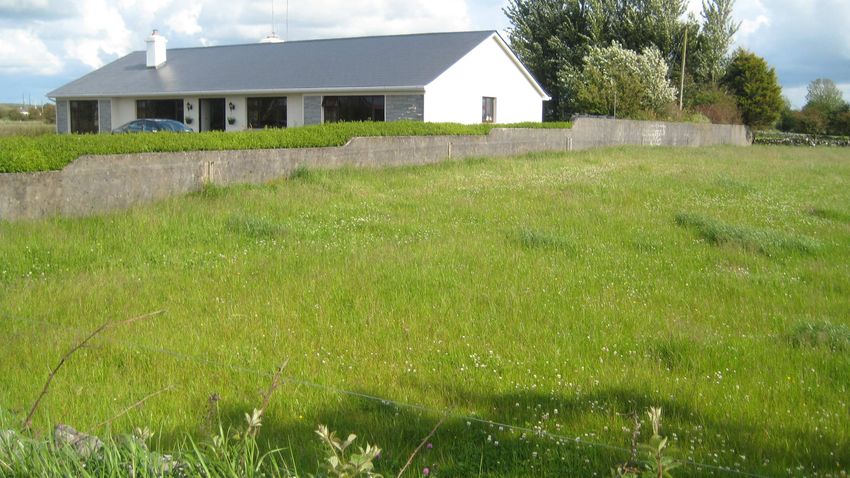
Clare River (Claregalway) Flood Relief Scheme
Stage 2 - Environmental Assessment of Viable Options

                                           TABLE OF CONTENTS

1        INTRODUCTION ........................................................................................................................ 1
2        SYNOPSIS OF ENVIRONMENTAL CONSTRAINTS STUDY .................................................. 2
3        PROPOSED FLOOD ALLEVIATION MEASURES ................................................................... 5
4        IMPACT ASSESSMENT ............................................................................................................ 9
         4.1        DO-NOTHING ................................................................................................................... 9
         4.2        PREFFERED SCHEME MEASURES .................................................................................... 10
                    4.2.1       Lough Corrib to Curraghmore Bridge ............................................................. 10
                    4.2.2       Montiagh South .............................................................................................. 11
                    4.2.3       Montiagh North ............................................................................................... 13
                    4.2.4       Claregalway Village ........................................................................................ 15
                    4.2.5       Kiniska ............................................................................................................ 19
                    4.2.6       Lakeview ......................................................................................................... 21
                    4.2.7       Caherlea/Lisheenavalla .................................................................................. 23
                    4.2.8       Carnmore/Cashla ........................................................................................... 30
                    4.2.9       Footbridge ...................................................................................................... 32
         4.3        CUMULATIVE IMPACTS.................................................................................................... 34
5        CONCLUSIONS ....................................................................................................................... 36
                    5.1.1       Socio-Economic.............................................................................................. 36
                    5.1.2       Archaeological, Architectural and Cultural Heritage....................................... 36
                    5.1.3       Terrestrial Ecology ......................................................................................... 36
                    5.1.4       Aquatic Ecology .............................................................................................. 37
                    5.1.5       Soils, Geology and Hydrogeology .................................................................. 37
6        REFERENCES ......................................................................................................................... 38

                                                 LIST OF FIGURES

Figure 3.1      Locations of Proposed Measures

Figure 3.2       Preliminary design for proposed footbridge at Claregalway

                                                  LIST OF TABLES

Table 2.1       Environmental Constraints identified during Stage 1 of the Study .................................... 2

MGE0260RP0005                                                           i                                                                   Rev. F01
Clare River (Claregalway) Flood Relief Scheme
Stage 2 - Environmental Assessment of Viable Options

1 INTRODUCTION

In May 2011 the Office of Public Works (the OPW) appointed RPS as environmental consultants for
the Clare River (Claregalway) Flood Relief Scheme. The Clare River and main tributaries form part of
the Corrib Clare Arterial Drainage Scheme, which was constructed in the late 1950’s and early 1960’s,
for which the OPW have a statutory maintenance responsibility. These original Arterial Drainage
Scheme works involved substantial widening and deepening of the existing channel and tributaries
with the purpose of providing outfall for the drainage of agricultural lands.

In March 2010 the OPW commissioned Ryan Hanley Consulting Engineers to undertake two studies.
The first related to the Clare River and its main tributary, the Abbert River, within a study area from
Corofin to Lough Corrib. The study was commissioned as a result of severe damage and disruption
caused by flooding in the area in November 2009. The second study related to the townlands of
Carnmore East and Cashla on the R339 Galway to Monivea Regional Road, which was also affected
by flooding in November 2009. These studies should be read together, and are referred to as the
Engineering Studies for the remainder of this report.

The OPW are now progressing the Flood Relief Scheme to design stage and the required
environmental outputs associated with the Scheme are set out in three distinct stages as follows:

     Stage 1
    - Environmental Constraints Study
    - Public Consultation

     Stage 2
    - Environmental Assessment of Viable Options
    - Screening for Appropriate Assessment

     Stage 3
    - Environmental Impact Statement (EIS)
    - Appropriate Assessment (if deemed necessary as a result of the Appropriate Assessment
        Screening).
    - Public Consultation

Stage 1 Environmental Constraints Study and Public Consultation were completed in early June. This
report fulfils one required element of Stage 2 – to complete an Environmental Assessment of Viable
Options for the proposed Flood Relief Scheme.

The Environmental Assessment of Viable Options is tasked with reviewing the assessment of the
environmental effects of the flood alleviation options that have been identified in the Engineering
Studies, and suggest mitigation measures, where feasible (as per Tender documents, December
2010). This review will inform the Design Team in refining or changing the preferred scheme option.
This assessment also includes the environmental effects of the proposed footbridge.

MGE0260RP0005                                          1                                       Rev. F01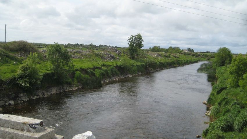
Clare River (Claregalway) Flood Relief Scheme
Stage 2 - Environmental Assessment of Viable Options

2 SYNOPSIS OF ENVIRONMENTAL CONSTRAINTS STUDY

The purpose of completing the Environmental Constraints Study was to identify where constraints may
impact upon specific proposed flood relief measures and in so doing inform both the stakeholder
consultation and design process for the scheme from an environmental view point. This report should
be read in conjunction with the Environmental Constraints Study.

The Study identified a number of significant environmental constraints as follows (*refers to figure and
table numbers from the Environmental constraints Study Report):

Table 2.1     Environmental Constraints identified during Stage 1 of the Study

  CATEGORY                 SUB                    SOURCE                 CONSTRAINTS                 MAP/TABLE
                        CATEGORY                                                                    REFERENCE*

Socio                Land Use &             Galway County          •   Existing land uses           Figure 2.1
Economic             Communities            Development Plan       •   Fisheries                    Table 2.3
                                            2009 – 2015            •   Clare River Walkway
                                            Stakeholder                Project
                                            constraints

                                            Angler’s Guide to
                                            Game Fishing in
                                            the Western
                                            Fisheries Region
                     Material assets                               •   Existing road network –      Figure 2.1
                                                                       impact on commuters          Figure 2.14
                                                                   •   Energy infrastructure –
                                                                       overhead &                   Table 2.12
                                                                       underground network
                                                                       e.g. ESB lines, Bord
                                                                       Gáis supply
                                                                   •   Water mains and
                                                                       private wells
                                                                   •   Proposed new WWTP
                                                                       at Claregalway
                                                                   •   Local authority licensed
                                                                       discharges to the Clare
                                                                       River
                     Landownership                                 •   Liaison     with     local
                     and access                                        landowners in relation
                                                                       to works proposed
                                                                   •   Storage or disposal of
                                                                       excavated materials
Archaeology &                               Legislative            •   Three Protected              Figure 2.2
Cultural                                    Constraints                Structures
Heritage                                                           •   Two NIAH structures
                                                                                                    Tables 2.4.1 &
                                            Galway County          •   19 Archaeological            2.4.2
                                            Development Plan           Heritage sites (including
                                            2009 – 2015                52 separate RMP
                                                                       listings and a national
                                                                       monument)
                                            Assessment by          •   Three Areas of
                                            Irish Archaeological       Archaeological Potential
                                            Consultancy

MGE0260RP0005                                             2                                            Rev. F01
Clare River (Claregalway) Flood Relief Scheme
Stage 2 - Environmental Assessment of Viable Options

  CATEGORY                 SUB                    SOURCE                 CONSTRAINTS                  MAP/TABLE
                        CATEGORY                                                                     REFERENCE*

Landscape &                                 Galway County             2 protected focal points      Figures 2.4
Visual                                      Development Plan           & views
                                            2009 – 2015
Ecology                                     Legislative            •   Compliance with the           Figure 2.6
                                            Constraints                Habitats and Birds
                                                                       Directives and National
                                                                                                     Tables 2.5 - 2.7
                                                                       legislation
                                            Stakeholder
                                                                   •   Designated habitats and
                                            constraints
                                                                       species Protected Flora
                                                                       and Fauna
                                            NPWS databases         •   Fisheries – salmonids,
                                                                       lamprey
                                            Published literature      Local Ecological
                                                                       Important Areas
Hydrology &                                 Stakeholder               Important fisheries           Figure 2.8
Water Quality                               Constraints                zones
                                                                      Compliance with the
                                                                                                     Table 2.2
                                                                       Water Framework
                                            Legislative                Directive
                                            constraints

                                            Western     River
                                            Basin Management
                                            Plan

Soils/Geology/                                                        Aquifer vulnerability         Figures 2.11 -
Hydrogeology                                                          Surface     water     and     2.13
                                                                       groundwater interaction       Tables 2.9 –
                                                                                                     2.12
Other                Waste                                         Requirement to handle,
Constraints          Management                                    store, remove and dispose
                                                                   of    waste      material    in
                                                                   accordance with relevant
                                                                   waste            management
                                                                   legislation
                     Traffic                                       - Crusheeny Bridge                Figure 2.14
                                                                       measures will lead to
                                                                       traffic diversions
                                                                   - Local roads in Montiagh
                                                                       North and Montiagh
                                                                       South townlands –
                                                                       Raising sections of
                                                                       access roads and
                                                                       increasing the size of a
                                                                       culvert in Montiagh
                                                                       South will cause traffic
                                                                       delays and possible
                                                                       diversions
                                                                   - Construction of the
                                                                       footbridge at
                                                                       Claregalway will cause
                                                                       traffic delays and
                                                                       disruption
                     Noise                                          Galway County Council           Figure 2.15
                                                                        Draft Action Noise Plan

MGE0260RP0005                                             3                                             Rev. F01
Clare River (Claregalway) Flood Relief Scheme
Stage 2 - Environmental Assessment of Viable Options

  CATEGORY                 SUB                    SOURCE         CONSTRAINTS                  MAP/TABLE
                        CATEGORY                                                             REFERENCE*

                                                               2008
                                                              Noise generated by the
                                                               timing        of     works
                                                               associated with the
                                                               implementation          of
                                                               alleviation      measures
                                                               may         impact      on
                                                               residential, commuting
                                                               and visitors to the study
                                                               area.
                     Air                                      Key       Indicators     of   Figure 2.16
                                                               Ambient Air Quality in
                                                               Ireland
                                                              Works associated with
                                                               implementation of flood
                                                               alleviation      measures
                                                               and      the     machinery
                                                               involved may generate
                                                               emissions and dust e.g.
                                                               bridge works, storage
                                                               and removal of waste
                                                               material etc.

MGE0260RP0005                                          4                                        Rev. F01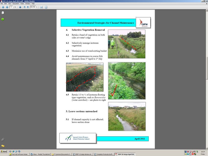
Clare River (Claregalway) Flood Relief Scheme
Stage 2 - Environmental Assessment of Viable Options
3 PROPOSED FLOOD ALLEVIATION MEASURES
The appointed design team have reviewed/altered/refined the proposed flood alleviation measures for
the Scheme. This has resulted following a review of the Engineering Reports (June and August 2010),
a review of the Environmental Constraints Report, June 2011 and analysis of comments received
during the public information evening held in Claregalway on the 8th of June 2011. In addition,
unsteady state modelling was undertaken, the purpose of which was to refine the measures proposed
by the Engineering Reports if deemed necessary.
Table 3.1 sets out the preferred flood relief scheme, and Figure 3.1 illustrates their locations.
Table 3.1 Summary of the Preferred Scheme
Summary of Potential Proposed Measures Comments
Flood Relief Measures
1 Lough Corrib to No measures proposed
Curraghmore Bridge
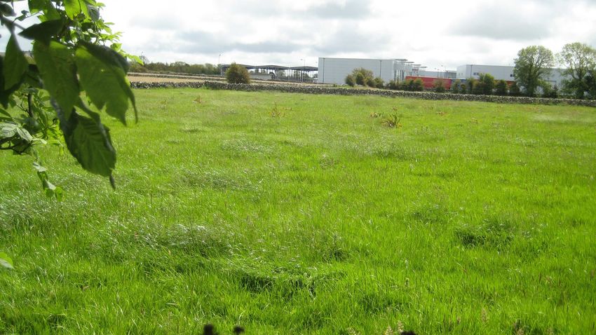
2 Miontach South 2a Raise approx. 1km of road, to a Images 3.1 and 3.2 below show the
minimum level of 8.60m OD. road section proposed to be raised
2b Upsize existing road culvert in and the existing culvert to be upsized.
conjunction with road works
2c Clean Drains in existing vicinity
3 Miontach North 3a Raise approx. 0. 460 km of road to Images 3.3 and 3.4 below show the
3b a minimum of 9.0m OD. road sections proposed to be raised.
Raise approx. 0. 785 km of road to
a minimum of 9.0m OD.
4 Claregalway Village 4b Regrade Clare River channel Images 3.5 and 3.6 show the location
upstream of and under the of the Nine Arches bridge and Clare
Claregalway bridge River downstream of Claregalway
4c Fill gap in wall at An Mhainistir bridge.
housing estate
4d Provide local embankment at old
Nine Arches bridge
5 Kiniska 5a Increase capacity of culverts on
OPW C3/5 stream
5b Clean OPW stream C3/5
6 Lakeview 6a Provide surface water outlet It was agreed that the outlet from the
through fields and along N17 to surface water drain from Lakeview
upstream of Claregalway Bridge would discharge to the Clare River
upstream of the Claregalway bridge
rather than downstream of the bridge
as originally proposed.
Images 3.7 and 3.8 illustrates the
proposed route from the corporate
park through Cúirt na hAbhainn
Estate.
7 Gortatleva No additional measures proposed
(Measures for Area 4 apply)
8 Caherlea/Lisheenavalla 8a Replace Crusheeny Bridge A Bridge Options Report was
8b Channel widening from 0.9km prepared by RPS which
upstream of Crusheeny Bridge to recommended the provision of a three
Claregalway span bridge to minimise the in-river
8c Cleaning and regrading of works. A Preliminary Report is
Islandmore OPW C3/7 and F.799/1 currently being prepared to obtain
arterial drains NRA approval. The bridge demolition
MGE0260RP0005 5 Rev. F01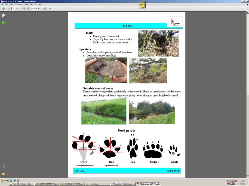
Clare River (Claregalway) Flood Relief Scheme
Stage 2 - Environmental Assessment of Viable Options
8d Raise local road in and replacement is to be undertaken
Caherlea/Lisheenavalla (future as advance works to ensure that the
measure) works are progressed as soon as
possible.
Crusheeny Bridge Cross-Section
Width
(m)
Parapet beam 0.5
Raised verge / verge 1.0
Hardshoulder / Hard Strip -
Carriageway 2.75
Central Reserve -
Carriageway 2.75
Hardshoulder / Hard Strip -
Raised verge / verge 1.5
Parapet beam 0.5
Total Width 9.0
The channel widening works will result
in a large amount of material being
excavated. The majority of the
excavation works are on the southern
bank of the river, with some
excavation on the northern bank in the
vicinity and upstream of Crusheeny
bridge. It is proposed that this material
will generally be spread adjacent to
the river as much as possible. The
approximate quantities of materials to
3
be excavated is 305,000 m . This
does not include the existing spoil
heaps adjacent to the river which will
also need to be removed in areas
where channel widening works are
proposed. The total volume is
currently being quantified.
Images 3.9 and 3.10 illustrate the
existing bridge at Crusheeny and the
view downstream from the bridge of
the Clare River.
9 Carnmore/Cashla Drainage of floodwater from the
affected area via a new drainage
pipeline/open drain to a local
surface water stream at Islandmore
In addition, a Footbridge is proposed for Claregalway, to be constructed alongside the Claregalway
Bridge. This Footbridge, is also assessed as part of this report. Figure 3.2 illustrates a preliminary
design for the footbridge.
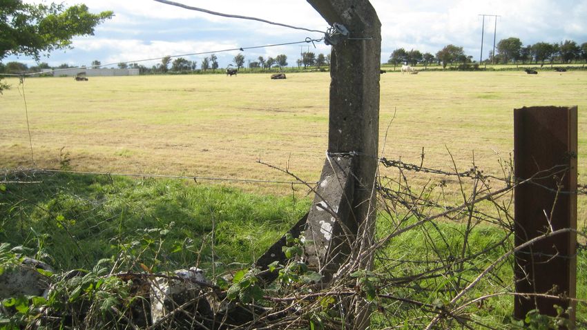
Images 3.1 to 3.12 illustrate the locations of the various measures proposed.
MGE0260RP0005 6 Rev. F01
Clare River (Claregalway) Flood Relief Scheme
Stage 2 - Environmental Assessment of Viable Options

Image 3.1 Road to be Raised                                Image 3.2 Existing culvert to be upsized

Image 3.3 Road to be Raised at Miontach                    Image 3.4 Road to be Raised at Miontach
North                                                      North

Image 3.5 Nine Arches Bridge                               Image 3.6 Clare      River   Downstream     of
                                                           Claregalway Bridge

Image 3.7 Cúirt na hAbhainn Estate                         Image 3.8 Claregalway Corporate Park

MGE0260RP0005                                          7                                          Rev. F01
Clare River (Claregalway) Flood Relief Scheme
Stage 2 - Environmental Assessment of Viable Options
Image 3.9 Crusheeny Bridge Image 3.10 Clare River Downstream of
Crusheeny Bridge
Image 3.11 Proposed Start of Surface Water Image 3.12 Proposed Route of Surface Water
Drain Drain
MGE0260RP0005 8 Rev. F01Clare River (Claregalway) Flood Relief Scheme
Stage 2 - Environmental Assessment of Viable Options
4 IMPACT ASSESSMENT
This section consists of an environmental assessment of each of the preferred flood relief measures.
Impacts have been described in accordance with the Glossary of Impacts set out in “Guidelines on the
Information to be contained in Environmental Impact Statements” (EPA 2002). Where relevant,
mitigation measures and/or environmental enhancement measures are proposed.
It should be noted that the assessment below and the potential mitigation measures set out may be
subject to refinement during the EIA process, which requires more in depth desktop analysis and an in
depth review of field inspections. Additional mitigation measures at EIA stage may be recommended
e.g. geophysical surveys and archaeological testing.
4.1 DO-NOTHING
In the absence of the flood relief measures proposed, impacts of periodic flooding are likely to
continue. Flooding in Claregalway town and in the Clare catchment above Claregalway Bridge is
caused exclusively by river floods, the characteristics of the river channel and their effect on the
discharge of high runoff volumes from the river catchment through Claregalway Bridge (Ryan Hanley,
2010). The flooding of the Clare River which followed the extreme rainfall in November 2009 caused
severe and prolonged hardship to businesses, to residents within the Clare catchment and to
commuters using the N17 and other minor roads in the vicinity. Flooding has also been recorded on
other occasions including the winter of 1990, December 1999, January 2005, and December 2006.
The worst affected areas from the November 2009 flood within the study area were:
• Miontach townland downstream of Claregalway Bridge. One house was flooded, and a
neighbouring house came close to flooding. Miontach townland was totally isolated by flooding;
• Claregalway village, where access to the N17, housing estates (An Mhainister) and commercial
properties (e.g. Arches Hotel) was hampered;
• Kinishka townland – access road flooded but remained passable;
• Lakeview – Cuirt na hAbhainn housing estate road flooded and houses almost flooded. Minor
flooding in front of the park. Lakeview housing estate roads were at risk of flooding;
• Gortatleva – land was flooded and one home flooded;
• Caherlea/Lisheenavalla townlands where sixteen houses were completely flooded or were at risk
of flooding. Local road access was hampered by raised water levels in turlough area;
• Carnmore/Cashla – three houses were flooded, and seven houses and two business premises
were at risk of flooding. Many houses were cut off by the flooding of local roads and the Regional
Road R339. Land was also flooded.
Modelling undertaken by Ryan Hanley (2010) indicated that, serious flooding at Claregalway and in
the Crusheeny area with potential flood levels of 11.31m OD upstream of Claregalway Bridge and
13.93m OD at Caherlea/Lisheenavalla under potential future climate change conditions, would occur
under the ‘do-nothing scenario’.
MGE0260RP0005 9 Rev. F01Clare River (Claregalway) Flood Relief Scheme
Stage 2 - Environmental Assessment of Viable Options
Such events are likely to continue to exert disruption and hardship within the study area in the
absence of the flood relief scheme.
4.2 PREFFERED SCHEME MEASURES
4.2.1 Lough Corrib to Curraghmore Bridge
There are no works planned from Lough Corrib to Curraghmore Bridge. This part of the study area
suffers from flooding relating to lake levels in Lough Corrib, and the main impact of this flooding is on
agricultural land and bog. No property or property access was affected in this area in November 2009.
The N84 Headford road is raised above flood levels.
However the following is noted in terms of archaeology:
- This area is characterised by the presence of an Area of Archaeological Potential (AAP)
associated with the riverine environment around the Clare River (AAP1) and the surrounding
bog land below Claregalway village is also an AAP (AAP2) (for the location of AAP1 and
AAP2 –refer to Figure 2.2 of the Environmental Constraints Study).
- Curraghmore Bridge is of modern construction and is of no architectural heritage merit.
MGE0260RP0005 10 Rev. F01Clare River (Claregalway) Flood Relief Scheme
Stage 2 - Environmental Assessment of Viable Options
4.2.2 Montiagh South
Potential Impacts Quality Duration Type Significance Suggested Mitigation
Measures/Environmental Enhancements
Terrestrial ecology
Local habitat disturbance at culvert and drain site Negative Short term Reversible. The Slight None required
(habitats comprise Improved Agricultural Grassland habitats at this location
GA1 and species-poor Wet Grassland GS4) will most likely
recolonise naturally
and return to their
previous form.
Socio-economic
Disruption to local road users and services Negative Short term Cumulative Significant • Provide prior warning of road closure to
road users.
• Provide local diversion during works.
Aquatic ecology
2a: Raised road construction over and in proximity Negative Short term Construction phase + Slight local A detailed design and method statement
to drain at M35606, 33525 has the potential to Cumulative (inputs of impacts due to should be drawn up by the contractor indicating
contribute sediment and silt, with a risk of cement silt to Clare River) in low value of what measures will be taken to avoid, (a)
and hydrocarbon spills (diesel, hydraulic fluid) to association with other drain habitat. sediment or soil loss and; (b) hydrocarbon
the watercourse. There are many smaller drains measures. Sluggish nature contamination, associated with all aspects of
adjacent and perpendicular to both sides of the of drain means the road construction phase, and how these will
existing road in this area, and whilst they have low that silt is likely be monitored for effectiveness.
habitat value, they are conduits to the larger drain to settle within
and on into the Clare River, downstream, where the drain rather
there could be impacts on fisheries values there. than discharge
immediately to
the Clare
.Works are
outside the
cSAC.
2b: Culvert replacement - method for replacement Negative Short term Construction phase + Slight local As for 2a.
is undefined – potential to contribute sediment and Cumulative (inputs of impacts due to
silt, with a risk of cement and hydrocarbon spills silt to Clare River) in low value of
(diesel, hydraulic fluid) to the watercourse. As for association with other drain habitat.
2a. Localised habitat disturbance. measures. As for 2a.
Works are
MGE0260RP0005 11 Rev. F01Clare River (Claregalway) Flood Relief Scheme
Stage 2 - Environmental Assessment of Viable Options
Potential Impacts Quality Duration Type Significance Suggested Mitigation
Measures/Environmental Enhancements
outside the
cSAC.
2c: Drainage operations - physical habitat disturbance Negative Short term Construction phase Moderate, local, There is a huge amount of low value drain
and/or loss over a significant linear length of impacts, with habitat in this vicinity, so cleaning of those
watercourse. There were a number of different slight impact highlighted, whilst causing localised habitat
habitat types within the drains earmarked for cleaning, overall. Works loss, will have negligible impact overall and will
most have only low value of local importance. The are mostly not affect the integrity of this habitat type within
more easterly of the Montiagh South drains outside the the cSAC.
earmarked for cleaning, is a broad deep channel cSAC.
(probably a tributary), which nevertheless has no All drainage operations should be carried out in
suitable salmonid habitat and is unlikely to be accordance with OPW’s Environmental
important for lamprey ammocoetes given the Management Protocols and Standard
absence of suitable spawning areas. The habitat Operating Procedures (SOP) (Appendix A)
however would be suitable for coarse fish such as All drainage operations should be carried out in
roach, other cyprinids and perhaps small pike. The close consultation with Inland Fisheries Ireland.
other drains in the Montiagh South area, centred
on M33918 33078 have no obvious fisheries value, Cleaning of these channels should be delayed
although non-protected species such as 3-spined until late summer when all amphibians have
stickleback may be present. adopted more terrestrial behaviour.
A high abundance of newt tadpoles in the more Both newts and frogs are protected under the
westerly drainage network at M 34194 32996. There Wildlife Acts (1976 and 2000).
were also small frogs observed on land around the Any disturbance to a newt breeding site would
drains. The area is clearly important for amphibians. require a licence from NPWS and potentially a
compensation plan would need to be proposed
if the site was to be lost. Further investigation
of the drains in that area may be necessary to
see how much residual habitat will remain after
the proposed drainage.
2c: Drainage operations – mobilisation of silt during Negative Short term Construction phase + Moderate local All drainage operations should be carried out in
in-channel works which may have impacts on Cumulative (inputs of impacts, with a accordance with OPW’s Environmental
fisheries values of the Clare River to which all drains silt to Clare River) in possibility of Management Protocols and Standard
in this area are a conduit. The sluggish nature of association with other slight impacts Operating Procedures (SOP) (Appendix A)
the drains in this vicinity means that silt is likely to measures. within the Clare
settle within them, but may become mobilised River. Works All drainage operations should be carried out in
during events. are mostly close consultation with Inland Fisheries Ireland.
outside the
None of these drains has recognisable salmonids cSAC. Carry out works in a downstream direction so
fisheries habitat and are also unlikely to contain that in-situ vegetation can act as a buffer to the
lamprey ammocoetes due to absence of suitable mobilisation of silt downstream to the Clare
spawning areas nearby. Non protected species River.
MGE0260RP0005 12 Rev. F01Clare River (Claregalway) Flood Relief Scheme
Stage 2 - Environmental Assessment of Viable Options
Potential Impacts Quality Duration Type Significance Suggested Mitigation
Measures/Environmental Enhancements
such as 3-spined stickleback may be present.
Undertake this measure in different sequence
There are no known spawning areas in the lower to other measures to limit cumulative impacts.
section of the Clare, so low levels of silt that Both the OPW and the Engineering Report
escape to the main channel would not impact indicate that the Clare has a flow regime that
salmon redds. does not favour excessive silt deposition and
limited intermittent inputs should have
negligible impact on the river, overall. Works
should be timed to occur in predicted low
rainfall period.
Archaeology and cultural heritage
The proposed road raising and upsizing the Negative Permanent Irreversible Significant It is recommended that ground disturbances
existing road culvert may have an adverse impact associated with the proposed works be
on archaeological features or deposits that have monitored by a suitably qualified archaeologist.
the potential to be located beneath the current Full provision should be made for the resolution
ground level within Area of Archaeological Potential of any archaeological features or deposits that
2 (bogland). This would be caused by excavation are discovered, should that be deemed the
required as part of the proposed scheme. most appropriate way to proceed.
No adverse impact is anticipated on AH 1
(children’s burial ground), as it is located 260m SW
of the proposed road works.
Soil, geology and hydrogeology
Imperceptible impact on soils and geology due to Negative Permanent Residual Imperceptible Any excavated soils/rock should be reused in
the disturbance and loss of soils and rocks during the scheme or disposed in an appropriate local
works. waste facility.
4.2.3 Montiagh North
Potential Impacts Quality Duration Type Significance Mitigation Measures/Environmental
Enhancements
Terrestrial ecology
3a: Localised disturbance of Cutover bog habitats Negative Short Term Reversible (the habitats 3a: Moderate 3a: Works should be minimised on the northern
on either side of the road. These habitats are should naturally recover side of the road at this location, in order to
considered to be of Local Importance (Higher post-construction) 3b: Slight avoid the areas of species-rich marsh and
Value). cutover bog. Works here should be supervised
by an ecologist.
3b: Localised disturbance of Wet Grassland and
MGE0260RP0005 13 Rev. F01Clare River (Claregalway) Flood Relief Scheme
Stage 2 - Environmental Assessment of Viable Options
Potential Impacts Quality Duration Type Significance Mitigation Measures/Environmental
Enhancements
Marsh habitats on either side of the road. These 3b: No mitigation required.
habitats are of Local Importance (Lower Value).
Socio-economic
Disruption to local road users and services Negative Short term Cumulative Significant • Provide prior warning of road closure to
road users.
• Provide local diversion during works.
Aquatic ecology
3a: - Raised road construction at, and near, the Negative Short term Construction phase + Significant local The tributary upstream of the road has been
tributary running from Gortadooey, has the Cumulative (inputs of impact due to recently maintained (20/7/11) and there is an
potential to contribute sediment and silt, with a risk silt to Clare River) in fisheries agreement between IFI and OPW about the
of cement and hydrocarbon spills (diesel, association with other values. Works section downstream of the road where
hydraulic fluid) to the watercourse, which could measures. are outside the spawning gravels are present, however, a
impact on fisheries values identified in the lower cSAC. detailed design and method statement
section of stream. Silt can smother spawning should be drawn up by the contractor
gravels and benthic fauna upon which fish feed. It indicating what measures will be taken to
can also abrade and clog fish gills, affecting avoid, (a) sediment or soil loss and; (b)
respiration. hydrocarbon contamination, associated with
all aspects of the road construction phase,
There are indications from observations of this and how these will be monitored for
stream between the road bridge and the Clare effectiveness. A pre-construction
River confluence of a varied habitat including electrofishing survey is also recommended in
short riffles and shallow glides, and trout and order to assess the current status with regard
possibly brook lamprey spawn within the stream. to salmonids (probably only trout) and
This part of the stream is not earmarked for lamprey ammocoetes (probably only Brook
cleaning but would still be susceptible to siltation lamprey) in the Gortadooey Stream.
from road raising and culvert replacement, which
could degrade the habitat.
3b: Raised road construction at, and near, a large Negative Short term Construction phase + Slight – due to A detailed design and method statement
(4m) sluggish drain at M36155 34276 has the Cumulative (inputs of low gradient should be drawn up by the contractor
potential to contribute sediment and silt, with a risk silt to Clare River) in and flow in indicating what measures will be taken to
of cement and hydrocarbon spills (diesel, association with other drain, where silt avoid, (a) sediment or soil loss and; (b)
hydraulic fluid) to the watercourse. There are measures. is likely to settle hydrocarbon contamination, associated with
many drains along both sides of the existing road before reaching all aspects of the road construction phase,
in this area, and whilst they have low habitat the Clare. and how these will be monitored for
value, they are all conduits to the Clare River and Works are effectiveness.
could have impacts on fisheries values there. outside the
cSAC.
Archaeology and cultural heritage
The proposed road raising may have an adverse Negative Permanent Irreversible Significant It is recommended that any ground
impact on archaeological features or deposits that disturbances associated with the proposed
MGE0260RP0005 14 Rev. F01Clare River (Claregalway) Flood Relief Scheme
Stage 2 - Environmental Assessment of Viable Options
Potential Impacts Quality Duration Type Significance Mitigation Measures/Environmental
Enhancements
have the potential to be located beneath the works that require the excavation of virgin
current ground level within Area of Archaeological ground, be monitored by a suitably qualified
Potential 2 (bogland). This would be caused by archaeologist. Full provision should be made
any excavation required as part of the proposed for the resolution of any archaeological
scheme. features or deposits that are discovered,
should that be deemed the most appropriate
way to proceed.
Soils, geology and hydrogeology
Imperceptible impact on soils and geology due to Negative Permanent Residual Imperceptible Any excavated soils/rock should be reused in
the disturbance and loss of soils and rocks during the scheme or disposed in an appropriate
works. local waste facility.
4.2.4 Claregalway Village
Potential Impacts Quality Duration Type Significance Mitigation Measures/Environmental
Enhancements
Socio-economic
Disruption to local land users and anglers Negative Short term Cumulative Significant • Provide prior warning of disruption to
land owners and angling clubs.
Potential for disruption to power supply. The Negative Short term Residual Slight • Liaison with ESB is required prior to
110kv line to the west of Claregalway crosses the any works being undertaken
Clare River approximately 0.3km west of the • Prior notice to those supplied by this
Friary. A 38kv line roughly follows the route of the linke required
main N17 road from north to south and crosses
the Clare River approximately 0.8km east of the
castle located in Claregalway village. The
medium voltage 10KV ESB line follows the N17
primary road and crosses the Clare River in
Claregalway village.
Disruption to utilities: The village of Claregalway, Negative Short term Residual Slight • Liaise with Bord Gais regarding
and Lakeview townland, are also supplied with potential disruption and provide prior
natural gas by An Bord Gais. The distribution warning to facilitate works.
network follows the N18 from Carnmore Cross
Roads and turns right at the N18/N17 junction in
Claregalway to supply Claregalway village.
MGE0260RP0005 15 Rev. F01Clare River (Claregalway) Flood Relief Scheme
Stage 2 - Environmental Assessment of Viable Options
Potential Impacts Quality Duration Type Significance Mitigation Measures/Environmental
Enhancements
Terrestrial ecology
4b Destruction of potential otter holt and localised 4b Negative Short Term 4b: Irreversible (loss of 4b: Major 4b: Otter holt should be monitored for
habitat disturbance. Impact Otter holt may result in 4d: Moderate activity, excluded (if necessary) and
4c Neutral Impact 4c Neutral the death of an animal) excavated under licence from the NPWS.
4d Localised habitat disturbance (Marsh habitat) Impact
4d Negative 4d: Reversible (the 4d: Works should be minimised on the
Impact habitats should naturally eastern side of the road at this location, in
recover post- order to avoid the area of species-rich Dry
construction) Calcareous and Neutral Grassland. Works
here should be supervised by an ecologist.
Aquatic ecology
4b: Mortality to in-channel flora and fauna owing Negative Long-term Construction phase + Significant, but All drainage operations should be carried
to, in-channel, mechanical, works along the Clare cumulative (in largely out in accordance with OPW’s
River from 900m upstream Crusheeny Bridge to association with other unknown until Environmental Management Protocols
Claregalway Bridge. It is unknown what methods measures) methods are and Standard Operating Procedures
are proposed to carry out ‘regrading’ works and defined. Works (SOP) (Appendix A). Particular attention
methodology will exert a considerable bearing on are within the should be given to SOP for white-clawed
impact significance. For example, channel cSAC. crayfish.
dewatering for works to occur in the dry will have
different effects than in-channel works in the wet. All drainage operations should be carried
Crayfish were not identified in the stretch near the out in close consultation with Inland
bridge, but access was limited by construction Fisheries Ireland.
works. Otter spraint with white clawed crayfish Works in the dry give rise to the potential
remains were recorded here during 1981 and to rescue and relocate crayfish if they are
1991 studies, but these records are now too old to present (unlikely) and they emerge from
be reliable indicators of current presence. Also, refuges during a draw down. However, in
otters can range considerable distances and the event that channel works occur in-
crayfish remains may not have been those of local channel – this would cause direct mortality
populations. At present it is unlikely that crayfish as it is unlikely that animals could be
are present in any great numbers, if at all, near efficiently trapped/captured and removed.
the bridge since habitat is poor-to-sub optimal with
swift flows, a lot of bedrock, embedded boulder, All efforts should be made to minimise the
and very little marginal habitat owing to loss of crayfish and methods and resulting
channelisation. But the possibility of presence channel characteristics should be
can not be entirely ruled out. conducive to habitat reinstatement and
recolonisation. This may be very difficult,
if not impossible given the depth of
excavation proposed. Given the
significance of this measure, further
investigations may be necessary to
MGE0260RP0005 16 Rev. F01Clare River (Claregalway) Flood Relief Scheme
Stage 2 - Environmental Assessment of Viable Options
Potential Impacts Quality Duration Type Significance Mitigation Measures/Environmental
Enhancements
determine the overall significance should
this part of the river become uninhabitable
for crayfish following measures.
A pre-construction electrofishing survey is
recommended in the riffle/rapid section
downstream of Claregalway Bridge.
4b: Changes to hydromorphology and flow Negative Long term Construction phase and Significant - IFI in-house experts should be
dynamics, in particular, the loss of a riffle/rapid residual careful commissioned to assist in the detailed
downstream of the bridge where loss of flow mitigation may design of the channel regrading and
diversity will result in changes to the benthic well reduce the reinstatement. Retaining finer substrate
fauna, perhaps a decrease in diversity and loss of degree of elements within the regraded stretch will
more sensitive species that inhabit faster flows. impact but the be a challenge because the regrading is
Fish also utilise these areas, but the densities are habitat likely to uncover mainly bare bedrock.
unknown. alteration will
remain IFI in Galway have suggested that a
This is the only section of turbulent water and significant in deeper low flow channel should be cut
cascade / boulder weir throughout this part of the terms of parallel to the southern bank throughout
Clare. It provides significant re-aeration potential reduced habitat the regraded stretch to facilitate fish
and is likely to contribute to an elevated density of diversity for passage during very low flows.
juvenile salmon and trout in the waters within 50 salmonids in
to 100m downstream. In low flows it provides a Consider reinstating similar habitat at the
particular. downstream end of the regraded section,
depth of water upstream of as far as the bridge Works are
and beyond. The loss of this feature may see a possibly by using similar sized boulders
within the excavated during regrading works in the
reduction in densities of younger salmon and trout cSAC.
in that stretch. It may lead to very shallow water upstream section. The design could
upstream during very low flows making fish incorporate the creation of flow
passage difficult. characteristics similar to the existing
situation by grading the channel
The section beneath the bridge and upstream of it specifically towards the downstream end.
is already quite uniform and the habitat probably The rapid/riffle should be qualitatively
won’t change significantly as a result of electrofished to determine fisheries
deepening. values.
4b: Mechanical works in the river will lead to Negative Short term Construction phase Moderate to Define methodology.
increased suspended solids levels which may Significant, but
abrade the gills of any juvenile salmon in the area largely All drainage operations should be carried
increasing the risk of stress or disease. unknown until out in accordance with OPW’s
methods are Environmental Management Protocols
defined. and Standard Operating Procedures
(SOP) (Appendix A)
All drainage operations should be carried
MGE0260RP0005 17 Rev. F01Clare River (Claregalway) Flood Relief Scheme
Stage 2 - Environmental Assessment of Viable Options
Potential Impacts Quality Duration Type Significance Mitigation Measures/Environmental
Enhancements
out in close consultation with Inland
Fisheries Ireland.
4b: Habitat disturbance and loss associated with Negative Short term Construction phase + Moderate to Define methodology.
regrading of channel. Given that crayfish are Cumulative Significant, but
unlikely to exist here in any great numbers, if at methods as yet All drainage operations should be carried
all, the impacts will mostly affect salmonids and unknown. out in accordance with OPW’s
lamprey. Environmental Management Protocols
and Standard Operating Procedures
Loss of the riffle/rapid has been discussed, and (SOP) (Appendix A)
may be significant given the rarity of the habitat
unit. The rest of the habitat is a long glide which is All drainage operations should be carried
well represented on the Clare and is of less out in close consultation with Inland
significance. Fisheries Ireland.
4b: The section of deepened channel may cause Positive Long term Residual Slight to Modelling of the drop in upstream water
changes to hydromorphology in (an unknown moderate, but levels would be useful to determine the
length of) the channel upstream of the proposed unknown until full impact significance. It may be that a
works. The effects could be, for example, reduced levels are small weir is required to maintain
depths and alteration to flow dynamics, such as defined. upstream water levels, however, the
increased local velocities which may affect aquatic creation of riffles and runs is also
habitat. For example, increased upstream desirable for fisheries. It is probably
velocities may benefit fauna by the creation of important that any lowering of the water
riffle areas and clean, bouldery glides which are levels upstream during regrading occurs
more optimal habitat for juvenile salmon and trout in such a way that levels drop slowly so
and sensitive macroinvertebrate species. that fish occupying marginal habitat can
escape to the main channel. There would
need to be a well defined low flow channel
incorporated in the design to ensure fish
passage and low flow connectivity. The
creation of an upstream riffle/rapid area
that may result could compensate for the
loss of the downstream riffle/rapid.
4c: Wall blocking will have no impacts Neutral N/A N/A No impact N/A
4d: The extent of this is unclear and the Negative Short-term Construction phase + Imperceptible to Sediment run-off control during
embankment material has not been defined. Cumulative (inputs of silt Slight, construction and settling phase.
Freshly excavated earthen embankment material to Clare River) in depending on
could contribute sediment to the Clare River association with other materials used.
causing damage to fish gills. measures.
MGE0260RP0005 18 Rev. F01Clare River (Claregalway) Flood Relief Scheme
Stage 2 - Environmental Assessment of Viable Options
Potential Impacts Quality Duration Type Significance Mitigation Measures/Environmental
Enhancements
Archaeology and cultural heritage
The proposed works will impact on the banks and Negative Permanent Irreversible Significant It is recommended that an underwater
bed of Clare River (AAP 1), due to the deepening archaeological survey be undertaken
of the channel. This has the potential impact upon within the relevant sections of the channel
archaeological features or artefacts such as to be affected by the proposed
organic remains/artefacts or archaeological development. Subject to site investigation.
deposits. Riverine environments are often a focus
for human activity from prehistory onwards and Underwater survey should be carried out
are areas of archaeological potential. (It should be by an archaeologist licenced to the
noted that massive alterations were made to the Department of Arts, Heritage and the
th
river during the late 19 century, which may have Gaeltacht. Full provision should be made
impacted on any such remains). available for the resolution of any
archaeological deposits, should that be
deemed the most appropriate way to
proceed.
Nine Arches Bridge is a protected structure (BH Negative Permanent Reversible Moderate It is recommended that the construction of
2). It is possible that the construction of the the embankment be undertaken
proposed embankment will adversely impact on sympathetically to the setting of the
the setting of the structure. bridge, especially with regards to views of
the structure form the existing main road
through Claregalway village.
Soils, geology and hydrogeology
Regrading the channel may induce additional Positive Permanent Residual Slight Reduction in water table levels may
groundwater flow where the water table rises reduce the potential for groundwater
above the base of the channel. This should lead to flooding.
improved drainage in the area.
4.2.5 Kiniska
Potential Impacts Quality Duration Type Significance Mitigation Measures/Environmental
Enhancements
Socio-economic
Disruption to local land users Negative Short term Cumulative Significant Provide prior warning of disruption to land
owners.
MGE0260RP0005 19 Rev. F01Clare River (Claregalway) Flood Relief Scheme
Stage 2 - Environmental Assessment of Viable Options
Potential Impacts Quality Duration Type Significance Mitigation Measures/Environmental
Enhancements
Disruption to power supply: There is a 20Kv ESB Negative Short term Cumulative Significant • Liaison with ESB is required prior to
line northeast of Claregalway village which follows any works being undertaken
the local road from Caraunkeelwy townland to • Prior notice to those supplied by this
Kiniska townland and ends at the tributary of the linke required
Clare River at Kiniska townland.
Terrestrial ecology
Negative - potential for loss of or damage to EU Negative Short term Reversible Major Works should be minimised on the eastern
Annex I habitat ‘Molinia meadows on calcareo side of the road at this location, in order to
us, peaty or clayey-silt-laden soils (Molinion avoid the area of Annex I habitat. Works
caeruleae)(6410)’ within Lough Corrib cSAC. here should be supervised by an ecologist.
Aquatic ecology
5a: Culvert replacement - method for replacement Negative Short term Construction phase + Slight local A detailed method statement should be
is undefined, but there is potential to contribute Cumulative (inputs of impacts due to drawn up by the contractor indicating what
sediment and silt, with a risk of cement and silt to Clare River) in low value of measures will be taken to avoid sediment
hydrocarbon spills (diesel, hydraulic fluid) to the association with other drain habitat. or soil loss associated with all aspects of
watercourse. Localised habitat disturbance. measures. Works are the construction phase and how these will
outside the be monitored for effectiveness.
cSAC.
5b: Drainage operations - physical habitat Negative Short term Construction phase 2c: Moderate Carry out works in a downstream direction
disturbance and/or loss over a significant linear local, impacts, so that in-situ vegetation can act as a
length of watercourse. The habitat was of low value with Slight buffer to the mobilisation of silt
and only of local importance and there were existing impact overall. downstream to the Clare River.
discharges to the stream that probably impact on Works are
water quality. mostly outside Undertake this measure in different
the cSAC. sequence to other measures to limit
There was no suitable spawning habitat for cumulative impacts. The Clare has a flow
salmonids, lamprey or crayfish habitat observed in regime that does not favour excessive silt
this drain, and none of these groups are expected to deposition and limited intermittent inputs
be present. It is possible that species such as 3- should have negligible impact on the river,
spined stickleback may be present. overall. Time works to occur in predicted
low rainfall period.
The proposed works will impact on the banks and Negative Permanent Irreversible Significant It is recommended that an underwater
bed of a small stream included within the archaeological survey be undertaken
designation of AAP 1, due to the cleaning of the within the relevant sections of the stream
channel. This has the potential to impact upon to be affected by the proposed
archaeological features or artefacts such as development. Subject to site investigation.
organic remains/artefacts or archaeological
deposits. (It should be noted that alterations were Underwater survey should be carried out
th
made to the stream during the late 19 century, by an archaeologist licenced to the
MGE0260RP0005 20 Rev. F01Clare River (Claregalway) Flood Relief Scheme
Stage 2 - Environmental Assessment of Viable Options
Potential Impacts Quality Duration Type Significance Mitigation Measures/Environmental
Enhancements
which may have impacted on any such remains). Department of Arts, Heritage and the
Gaeltacht. Full provision should be made
available for the resolution of any
archaeological deposits, should that be
deemed the most appropriate way to
proceed.
It is possible that excavation work associated with Negative Permanent Irreversible Significant It is recommended that any ground
increasing the size of existing culverts, may have disturbances associated with the
an adverse impact on previously unrecorded proposed works that require the
archaeological features or deposits that may exist excavation of virgin ground, be monitored
within the area. by a suitably qualified archaeologist. Full
provision should be made for the
resolution of any archaeological features
or deposits that are discovered, should
that be deemed the most appropriate way
to proceed.
4.2.6 Lakeview
Potential Impacts Quality Duration Type Significance Mitigation Measures/Environmental Enhancements
Socio-economic
Disruption to local land users Negative Short term Cumulative Significant Provide prior warning of disruption to land owners.
Disruption to utilities: The village of Negative Short term Residual Slight Provide prior warning of temporary disruption to Bord
Claregalway, and Lakeview townland, are Gais supplies if necessary to facilitate works.
also supplied with natural gas by An Bord
Gais. The distribution network follows the
N18 from Carnmore Cross Roads and turns
right at the N18/N17 junction in Claregalway
to supply Claregalway village.
Aquatic ecology
6a: Water quality changes associated with Negative Long-term Cumulative (in Moderate, Use guidance and design of Sustainable Urban
1
increased run-off to Clare River from semi- association with perhaps Drainage Systems (SuDS) to help reduce sediment
1
http://www.irishsuds.com/guidance_criteria.htm
MGE0260RP0005 21 Rev. F01Clare River (Claregalway) Flood Relief Scheme
Stage 2 - Environmental Assessment of Viable Options
Potential Impacts Quality Duration Type Significance Mitigation Measures/Environmental Enhancements
urban/industrial area as a point source. Such other urban Significant, and pollutant loading to Clare River for more frequent
run-off, when drained by pipe systems, discharges from depending on small run-off events. Hydrocarbon interception
results in run-off from virtually every rainfall the Claregalway design and systems should be included if car-parking areas and
event with high levels of pollution, particularly settlement) + level of future roads are contained within the drainage catchment.
in the first part of the run-off. It has been Residual (ongoing urban and/or
accepted that measure 6a. will not eliminate inputs of pollutants industrial A detailed method statement should be drawn up by
2009 flood levels, but what it may do is to Clare River) development the contractor indicating what measures will be taken
increase polluted run-off for small, more in the drained to avoid sediment or soil loss associated with all
frequent, events which may have significance area. aspects of the construction phase and how these will
in relation to the Clare fishery. be monitored for effectiveness.
6a: Construction phase - potential to Negative Short term Construction Moderate Construct drain and lay pipe whilst leaving a 20m,
contribute sediment and silt, with a risk of phase + undisturbed buffer section between this and the Clare
cement and hydrocarbon spills (diesel, Cumulative (inputs River. Only connect the lower end of the conduit once
hydraulic fluid) which can run-off from the of silt to Clare all works upstream are complete and fines and spills
open sections of drain and be piped to the River) in have been removed or settled.
Clare river. association with
other measures. A detailed method statement should be drawn up by
the contractor indicating what measures will be taken
to avoid sediment or soil loss associated with all
aspects of the construction phase and how these will
be monitored for effectiveness.
6a: Possible hydrological changes at Neutral Long-term Residual Imperceptible. Provide stable boulder rip-rap reinforcement at outflow
discharge site to Clare River which can affect to Clare River, if necessary, to prevent erosion.
benthic flora and fauna. The channel
characteristics above Claregalway Bridge will
not present any issues in terms of this new
input, primarily because substrates are
generally embedded boulder and bedrock
with limited microhabitat for fauna.
The proposed works may impact on the Negative Permanent Irreversible Significant It is recommended that an underwater archaeological
banks and bed of the Clare River due to the survey be undertaken within the outfall location.
construction of a drainage outfall upstream of Subject to site investigation.
the Claregalway Bridge. This has the
potential to impact upon archaeological Underwater survey should be carried out by an
features or artefacts such as organic archaeologist licenced to the Department of Arts,
remains/artefacts or archaeological deposits. Heritage and the Gaeltacht. Full provision should be
(It should be noted that alterations were made available for the resolution of any archaeological
made to the stream during the late 19
th deposits, should that be deemed the most appropriate
century, which may have impacted on any way to proceed.
such remains).
MGE0260RP0005 22 Rev. F01Clare River (Claregalway) Flood Relief Scheme
Stage 2 - Environmental Assessment of Viable Options
Potential Impacts Quality Duration Type Significance Mitigation Measures/Environmental Enhancements
Archaeology and cultural heritage
It is possible that excavation work associated Negative Permanent Irreversible Significant It is recommended that any ground disturbances
with the insertion of a surface water drain associated with the proposed works be monitored by a
through Lakeview to Claregalway, may have suitably qualified archaeologist. Full provision should
an adverse impact on previously unrecorded be made for the resolution of any archaeological
archaeological features or deposits that may features or deposits that are discovered, should that
exist within the area. be deemed the most appropriate way to proceed.
Soils, geology and hydrogeology
Flooding in this area was as a result of Positive Permanent Residual Moderate Measures should provide some alleviation to
groundwater flooding which is known to occur groundwater flooding in the area.
during winter months.
Surface water drain to be installed to drain
some portion of the flood water but
inundation will still occur during peak events.
This will result in a minor alteration to
groundwater levels and flow Residualions in
the vicinity of the flooding but there are not
groundwater dependant ecosystems
associated with these features.
4.2.7 Caherlea/Lisheenavalla
Potential Impacts Quality Duration Type Significance Mitigation Measures/Environmental
Enhancements
Terrestrial ecology
8a Loss of bankside vegetation (scrub, earth 8a Negative Short Irreversible 8a: Slight 8a: None required
banks) 8b Negative Term 8b: Significant 8b: Badger sett should be monitored for activity,
8c Negative 8c: Major excluded (if necessary) and excavated under
8b Loss of bankside vegetation (scrub, dry 8d Neutral licence from the NPWS. Works at this location
calcareous and neutral grassland and wet should be minimised and should be supervised
grassland), loss of badger sett. by an ecologist.
8c: Works at this location should be minimised
8c Potential direct impacts to an area of Annex I and should be supervised by an ecologist.
habitat ‘Molinia meadows on calcareous, peaty or
MGE0260RP0005 23 Rev. F01You can also read