Environment Plan West Tryal Rocks 2 Well Abandonment EP - NOPSEMA
←
→
Page content transcription
If your browser does not render page correctly, please read the page content below
-

                        Environment Plan
                      West Tryal Rocks 2 Well
                        Abandonment EP

    Document ID:               ABU-COP-03086
    Revision ID:               1
    Revision Date:             01 April 2021
    Next Revision Due          01 April 2026
    Information Sensitivity:   Company Confidential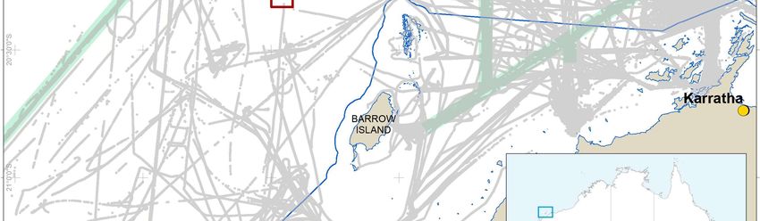
Environment Plan
West Tryal Rocks 2 Well Abandonment EP
Controlled document
Environment Plan
West Tryal Rocks 2 Well Abandonment EP
Document information
Document Number ABU-COP-03086 Revision 1
Document Owner Ian Nott Department Owner Wells
Revision history
Rev No. Description Date Prepared By Approved By
0.1 Issued for Review 9 March 2021 D. Salins
0 Issued for Submission 26 March 2021 D. Salins D. Smith
1 Updated for OMR/ Issued for Submission 01 April 2021 D. Salins D. Smith
Approvals
Name Signature Date
Author: Duanne Salins
Checked: Amie French
Approved: David Smith
Approved: Kathryn Barras
Approved: Ian Nott
Approved: Paul Clark
2021 by Chevron Australia Pty Ltd
This document contains proprietary information of Chevron Australia Pty Ltd. Any use of this document without express, prior, written permission
from Chevron Australia Pty Ltd and/or its affiliates is prohibited.
Document ID: ABU-COP-03086
Revision ID: 1 Revision Date: 01 April 2021 Page ii
Information Sensitivity: Company Confidential
Uncontrolled when Printed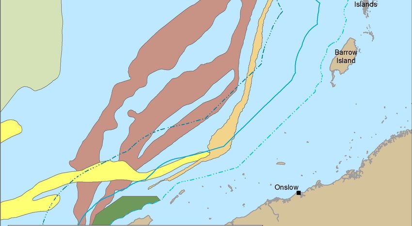
Environment Plan
                                                                                                            West Tryal Rocks 2 Well Abandonment EP

        Contents
        1     Environment Plan Summary........................................................................................... 2
        2     Introduction .................................................................................................................... 3
              2.1     Overview............................................................................................................... 3
              2.2     Location ................................................................................................................ 3
              2.3     Scope ................................................................................................................... 3
              2.4     Titleholder Details ................................................................................................. 5
              2.5     Legislative Requirements ...................................................................................... 5
              2.6     Stakeholder Engagement...................................................................................... 6
                      2.6.1      Identification of Relevant Stakeholders...................................................... 7
                      2.6.2      Provision of Sufficient Information to Stakeholders .................................... 9
                      2.6.3      Assessment of Merit of any Objections or Claims ...................................... 9
                      2.6.4      Ongoing Consultation .............................................................................. 12
        3     Assessment of Spill Scenarios ..................................................................................... 13
        4     Description of the Activity ............................................................................................. 15
              4.1     Overview............................................................................................................. 15
                      4.1.1      Location .................................................................................................. 15
                      4.1.2      Time Frame ............................................................................................. 15
                      4.1.3      Operational Area/ Environment that May be Affected .............................. 15
                      4.1.4      Activity Description .................................................................................. 15
        5     Description of the Environment .................................................................................... 17
              5.1     Regional Overview.............................................................................................. 17
                      5.1.1      Marine Environment ................................................................................ 19
              5.2     Socioeconomic Environment............................................................................... 24
                      5.2.1      Commercial Shipping .............................................................................. 24
                      5.2.2      Commercial Fishing and Aquaculture ...................................................... 25
                      5.2.3      Marine-based Tourism and Recreation.................................................... 25
                      5.2.4      Other Socioeconomic Values and Sensitivities ........................................ 25
              5.3     Particular Values and Sensitivities ...................................................................... 26
        6     Environmental Risk Assessment Methodology ............................................................. 27
              6.1     Identification and Description of the Petroleum Activity ....................................... 27
              6.2     Identification of Particular Environmental Values ................................................ 27
              6.3     Identification of Relevant Environmental Aspects................................................ 28
              6.4     Identification of Relevant Environmental Hazards ............................................... 28
              6.5     Evaluation of Impacts and Risk ........................................................................... 28
                      6.5.1      Consequence .......................................................................................... 28

Document ID: ABU-COP-03086
Revision ID: 1 Revision Date: 01 April 2021                                                                                                         Page iii
Information Sensitivity: Company Confidential
Uncontrolled when Printed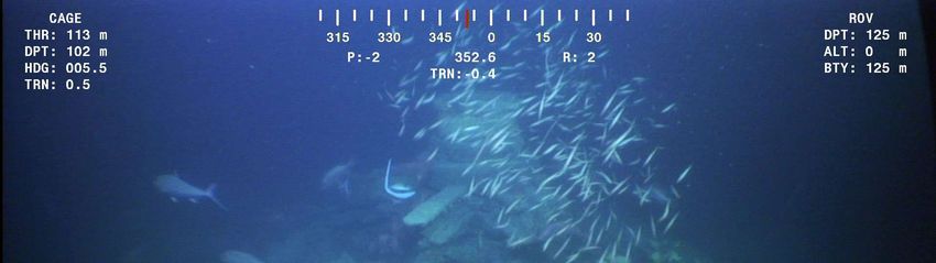
Environment Plan
                                                                                                          West Tryal Rocks 2 Well Abandonment EP

                      6.5.2      Control Measures and ALARP................................................................. 30
                      6.5.3      Likelihood ................................................................................................ 32
                      6.5.4      Quantification of the Level of Risk ........................................................... 32
              6.6     Risk and Impact Acceptance Criteria .................................................................. 32
                      6.6.1      Principles of ESD and Precautionary Principle ........................................ 33
                      6.6.2      Defining an Acceptable Level of Impact and Risks .................................. 34
                      6.6.3      Summary of Acceptance Criteria ............................................................. 34
              6.7     Environmental Performance Outcomes, Standards, and Measurement Criteria .. 35
        7     Environmental Risk Assessment and Management Strategy – Petroleum Activity ....... 36
              7.1     Physical Presence (Marine Users) ...................................................................... 36
              7.2     Seabed Disturbance ........................................................................................... 40
        8     Implementation Strategy .............................................................................................. 44
              8.1     Systems, Practices, and Procedures .................................................................. 44
                      8.1.1      Risk Management ................................................................................... 45
                      8.1.2      Management of Change .......................................................................... 46
                      8.1.3      Incident Investigation and Reporting ....................................................... 46
                      8.1.4      Emergency Management ........................................................................ 47
                      8.1.5      Stakeholder Engagement and Issues Management ................................ 47
                      8.1.6      Assurance ............................................................................................... 47
                      8.1.7      Competency ............................................................................................ 48
              8.2     Chain of Command and Roles and Responsibilities ............................................ 48
                      8.2.1      Chain of Command ................................................................................. 48
                      8.2.2      Roles and Responsibilities ...................................................................... 48
              8.3     Monitoring ........................................................................................................... 49
              8.4     Reporting ............................................................................................................ 49
                      8.4.1      Incident Reporting ................................................................................... 49
                      8.4.2      Routine Reporting ................................................................................... 50
              8.5     Environment Plan Review ................................................................................... 51
        9     Definitions and Abbreviations ....................................................................................... 52
        10 References .................................................................................................................. 54
        Appendix A               Operational Excellence Policy 530 .......................................................... 58
        Appendix B               Stakeholder Consultation Records .......................................................... 59
        Appendix C               Matters of National Environmental Significance Reports ......................... 61

        Tables
        Table 2-1: Titleholder Details ................................................................................................ 5
        Table 2-2: Titleholder Liaison Person Contact Details ........................................................... 5
Document ID: ABU-COP-03086
Revision ID: 1 Revision Date: 01 April 2021                                                                                                       Page iv
Information Sensitivity: Company Confidential
Uncontrolled when Printed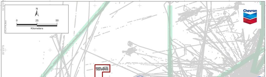
Environment Plan
                                                                                                     West Tryal Rocks 2 Well Abandonment EP

        Table 2-3: Commonwealth Legislative Requirements............................................................ 6
        Table 2-4: List of Relevant Stakeholders Consulted .............................................................. 8
        Table 2-5: Summary of Stakeholder Response and Objections and Claims ........................ 10
        Table 3-1: Spill Scenario Evaluation.................................................................................... 13
        Table 4-1: Location of the Wellheads that Remain In Situ ................................................... 15
        Table 5-1: Description of Provincial Bioregions ................................................................... 17
        Table 5-2: Summary of Relevant Conservation Plans – Marine Mammals .......................... 21
        Table 5-3: Summary of Relevant Conservation Plans – Marine Reptiles ............................. 22
        Table 5-4: Summary of Relevant Conservation Plans – Fish, Sharks, and Rays ................. 23
        Table 5-5: Summary of Relevant Conservation Plans – Seabirds and Shorebirds .............. 24
        Table 6-1: Principles of ESD in Relation to Petroleum Activity Acceptability Evaluations .... 33
        Table 6-2: CAPL Definition of Lower- and Higher-order Impacts and Risks ......................... 34
        Table 6-3: Acceptability Criteria .......................................................................................... 34
        Table 8-1: OEMS Focus Areas and Common expectations Relevant to this Activity ........... 45
        Table 8-2: Roles and Responsibilities ................................................................................. 48
        Table 8-3: Incident Reporting .............................................................................................. 49
        Table 8-4: Routine External Reporting Requirements ......................................................... 50
        Table 9-1: Definitions and Abbreviations ............................................................................. 52
        Table 10-1: References....................................................................................................... 54

        Figures
        Figure 2-1: Location of WTR-2 .............................................................................................. 4
        Figure 4-1: WTR-2 Wellhead Schematic ............................................................................. 16
        Figure 5-1: Wellhead Locations and Marine Regions .......................................................... 18
        Figure 5-2: Operational Area and Proximity to Key Ecological Features.............................. 20
        Figure 5-3 Commercial Shipping Density ............................................................................ 24
        Figure 6-1: Chevron Corporation Integrated Risk Prioritization Matrix ................................. 29
        Figure 6-2: ALARP Decision Support Framework ............................................................... 31
        Figure 7-1 Seabed floor surrounding WTR-2 OA................................................................. 40
        Figure 7-2 Epibenthic habitat around WTR-2 ...................................................................... 41
        Figure 7-3 Epibenthic habitat around WTR-2 ...................................................................... 41
        Figure 8-1: CAPL OEMS Process Overview ....................................................................... 44
        Figure 8-2: Chain of Command ........................................................................................... 48

Document ID: ABU-COP-03086
Revision ID: 1 Revision Date: 01 April 2021                                                                                                Page v
Information Sensitivity: Company Confidential
Uncontrolled when Printed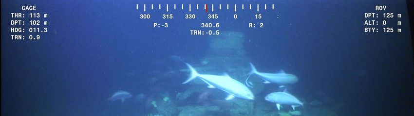
Environment Plan
                                                                       West Tryal Rocks 2 Well Abandonment EP

1           Environment Plan Summary
            This summary table was prepared from material provided in this Environment Plan
            (EP), and, as required by Regulation 11(4) of the Commonwealth Offshore
            Petroleum and Greenhouse Gas Storage (Environment) Regulations 2009
            (OPGGS(E)R), comprises:

                                                       Relevant section of EP containing EP Summary
EP Summary Material Requirement
                                                       material

The location of the activity                           Section 4

A description of the receiving environment             Section 5

A description of the activity                          Section 4

Details of the environmental impacts and risks         Section 7

The control measures for the activity                  Section 7

The arrangements for ongoing monitoring of the         Section 8
titleholders environmental performance

Response arrangements in the oil pollution             Section 8.1.4
emergency plan

Consultation already undertaken and plans for          Section 2.6
ongoing consultation

Details of the titleholders nominated liaison person   Section 2.4
for the activity

Document ID: ABU-COP-03086
Revision ID: 1 Revision Date: 01 April 2021                                                             Page 2
Information Sensitivity: Company Confidential
Uncontrolled when Printed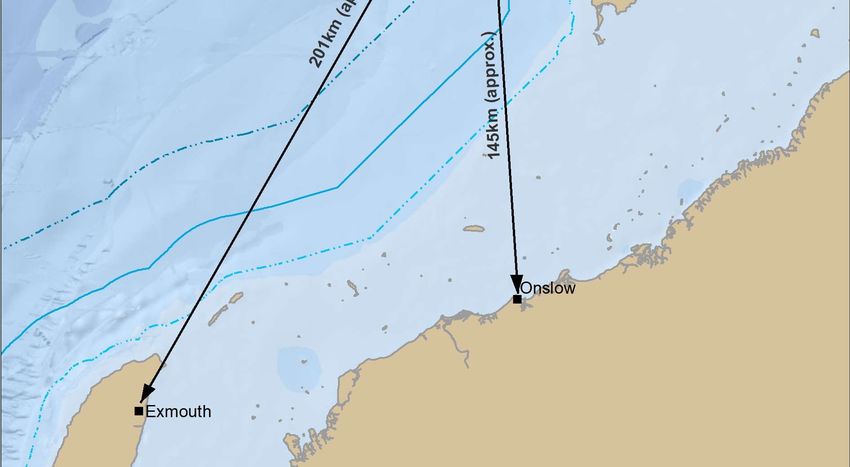
Environment Plan
                                                              West Tryal Rocks 2 Well Abandonment EP

2            Introduction
2.1    Overview
             West Australian Petroleum (WAPET) discovered the first of the Greater Gorgon
             gas fields, West Tryal Rocks, northwest of Barrow Island in 1973. The West Tryal
             Rocks 2 (WTR-2) well was drilled and abandoned by WAPET within exploration
             permit WA-25-P in 1974. Following abandonment, the wellhead was left in situ. In
             1991, the relevant graticular blocks were excised from WA-25-P and became the
             current retention lease WA-5-R.
             In 2000, Chevron Australia Pty Ltd (CAPL) became the operator of the oil and gas
             exploration and production assets previously managed by WAPET, including
             retention lease WA-5-R.
             Given the WTR-2 wellhead is to remain in situ, CAPL is submitting this
             Environment Plan (EP) to demonstrate that the obligations under section 572 of
             the Offshore Petroleum and Greenhouse Gas Storage Act 2006 (OPGGS Act) will
             be met.

2.2    Location
             The West Tryal Rocks gas field is located within retention lease WA-5-R, located
             approximately 145 km north of Onslow and 55 km north west of Barrow Island
             (Figure 2-1).

2.3    Scope
             This EP only covers the impacts and risks associated with the WTR-2 wellhead
             remaining in situ.

 Document ID: ABU-COP-03086
 Revision ID: 1 Revision Date: 01 April 2021                                                   Page 3
 Information Sensitivity: Company Confidential
 Uncontrolled when Printed
Environment Plan
                                                 West Tryal Rocks 2 Well Abandonment EP

Figure 2-1: Location of WTR-2

 Document ID: ABU-COP-03086
 Revision ID: 1 Revision Date: 01 April 2021                                      Page 4
 Information Sensitivity: Company Confidential
 Uncontrolled when Printed
Environment Plan
West Tryal Rocks 2 Well Abandonment EP
2.4 Titleholder Details
CAPL is the appointed titleholder taking action for the completed drilling program
within the retention lease on behalf of the companies listed in Table 2-1.
Table 2-1: Titleholder Details
Title Details Titleholders Licence Holder Address
WA-5-R WTR-2 Chevron (TAPL) Pty Ltd Chevron QV1, 250 St
Australia Pty Ltd Georges Tce
Chevron Australia Pty Ltd
Perth, WA,
JERA Gorgon Pty Ltd 6000
Mobil Australia Resources Company Pty
Limited
Osaka Gas Gorgon Pty Ltd
Shell Australia Pty Ltd
Tokyo Gas Gorgon Pty Ltd
In accordance with Regulation 15(2) of the Commonwealth Offshore Petroleum
and Greenhouse Gas Storage (Environment) Regulations 2009 (OPGGS(E)R),
details of the titleholder’s nominated liaison person are listed in Table 2-2.
Table 2-2: Titleholder Liaison Person Contact Details
Company Name Chevron Australia Pty Ltd
Nominated Liaison Person Ian Nott
Position Wells Manager
Business Address QV1, 250 St Georges Terrace, Perth, WA, 6000
Telephone Number +61 8 9216 4000
Email Address austdrillingops@chevron.com
If the titleholder’s nominated liaison person or contact details for the nominated
liaison person changes, CAPL will notify the Regulator in accordance with
Regulation 15(3) of the OPGGS(E)R. Specifically, a written notification including
any changes to Table 2-2 will be provided to NOPSEMA as soon as is practicable
after the change occurs.
In the unlikely event that the Titleholder changes, an evaluation will be conducted
(in accordance with Section 8.1.1). If it is found that the change in titleholder has
changed the manner in which the environmental impacts and risks of an activity
are managed, the new titleholder will submit a proposed revision of the
environment plan for the activity as soon as practicable.
2.5 Legislative Requirements
The proposed activities are located within Commonwealth waters and thus are
subject to Commonwealth legislation. In accordance with Regulation 13(4)(a) of
the OPGGS(E)R, a description of the Commonwealth legislative requirements
relevant to the environmental management of the proposed activity is included in
Table 2-3.
Document ID: ABU-COP-03086
Revision ID: 1 Revision Date: 01 April 2021 Page 5
Information Sensitivity: Company Confidential
Uncontrolled when Printed
Environment Plan
West Tryal Rocks 2 Well Abandonment EP
Table 2-3: Commonwealth Legislative Requirements
Demonstration of
Requirements relevant to the
how requirements
Legislation Description risks associated with the
are met within this
petroleum activity
Plan
Offshore Petroleum The OPGGS(E)R under An EP for a petroleum activity This EP
and Greenhouse Gas the OPGGS Act require a must be accepted by NOPSEMA
Storage Act 2006 titleholder to have an before activities commence
(OPGGS Act) and accepted EP in place for a
OPGGS(E)R 2009 petroleum activity. The
regulations ensure
petroleum activities are
undertaken in an
ecologically sustainable
manner and in
accordance with an EP.
Environment Provides for the protection On 28 February 2014, NOPSEMA This EP
Protection and and management of became the sole designated
Biodiversity nationally and assessor of petroleum and
Conservation Act internationally important greenhouse gas activities in
1999 (EPBC Act) flora, fauna, ecological Commonwealth Waters (in
communities, and heritage accordance with the Minister for
places. the Environment’s endorsement of
Under the EPBC Act, an NOPSEMA’s environmental
action requires approval authorisation process under
from the Commonwealth Part 10, section 146 of the EPBC
Minister for the Act)
Environment if the action
has, will have, or is likely
to have, a significant
impact on a matter of
national environmental
significance (NES)
Environment This act requires that CAPL will fulfil all obligations Section 2.6.4
Protection (Sea permits are required for under the Environment Protection
Dumping) Act 1981 any disposal of (Sea Dumping) Act 1981.
decommissioning and
surplus marine
infrastructure
2.6 Stakeholder Engagement
CAPL applied the following methodology to undertake consultation for this activity:
identify relevant stakeholders
provide sufficient information to enable stakeholders to understand how this
activity may affect their functions, interests, or activities
assess the merit of any objections or claims raised by the stakeholders
provide a response to the objection or claim, and ensure this is captured in the
EP.
This methodology is based on:
NOPSEMA Decision-Making Guideline – Criterion-10A(g) Consultation
Requirements (Ref. 1)
Document ID: ABU-COP-03086
Revision ID: 1 Revision Date: 01 April 2021 Page 6
Information Sensitivity: Company Confidential
Uncontrolled when PrintedEnvironment Plan
West Tryal Rocks 2 Well Abandonment EP
NOPSEMA’s Bulletin – Number 2 Clarifying statutory requirements and good
practice (Ref. 2)
Australian Petroleum Production and Exploration Association (APPEA)
Stakeholder Consultation and Engagement Principles and Methodology –
Draft (Ref. 3).
2.6.1 Identification of Relevant Stakeholders
CAPL engaged with Stakeholders regarding this activity in November 2020.
For this Environment Plan, CAPL elected to use the Western Australian Fishing
Industry Council’s (WAFIC) Oil and Gas Consultation Service to help determine
relevant commercial fisheries and fishers as well as review and distribute fishery-
specific consultation material.
Establishing relevance under the OPGGS(E)R depends on the nature and scale
of the activity and its associated risks. In accordance with Regulation 11A of the
OPGGS(E)R, a ‘relevant person’ is defined as:
each department or agency of the Commonwealth to which the activities to be
carried out under the environment plan, or the revision of the environment
plan, may be relevant
each department or agency of a State or the Northern Territory to which the
activities to be carried out under the environment plan, or the revision of the
environment plan, may be relevant
the department of the responsible State Minister, or the responsible Northern
Territory Minister
a person or organisation whose functions, interests, or activities may be
affected by the activities to be carried out under the environment plan, or the
revision of the environment plan
any other person or organisation that the titleholder considers relevant.
NOPSEMA (Ref. 2) states that persons or organisations whose functions,
interests, or activities are directly connected to the activities that an environment
plan provides for (e.g. a drilling or seismic survey activity) are considered relevant
persons.
Specifically, NOPSEMA (Ref. 2) clarify that ‘the activities to be carried out’ in the
context of Regulation 11A(1)(d), do not extend to a hypothetical, remote, or
speculative consequence from an activity such as a major oil spill.
Based on the risk assessment undertaken in this EP, CAPL understands that the
impacts of the planned activities are limited to the vicinity of the OA, thus persons
or organisations directly connected with functions, interests, or activities in this
area are taken to be relevant.
Given the nature of the activity is limited to the physical presence of the wellhead
on the sea floor, relevant persons are limited to other marine users that could
interact with the wellhead.
Table 2-4 summarises these stakeholders. A Stakeholder Engagement Log and
consultation records are provided in Appendix B.
Document ID: ABU-COP-03086
Revision ID: 1 Revision Date: 01 April 2021 Page 7
Information Sensitivity: Company Confidential
Uncontrolled when PrintedEnvironment Plan
West Tryal Rocks 2 Well Abandonment EP
Table 2-4: List of Relevant Stakeholders Consulted
Stakeholder Type Functions, interests/activities, and stakeholders consulted
Commonwealth and State This activity has the potential to interact with fisheries that trawl the seabed. Based
Fisheries (and peak body upon the location of the wellhead and fishing licenses that were identified to
associations) overlap these locations, the following stakeholders were considered relevant:
Western Australian Fishing Industry Council (WAFIC)
Australian Southern Bluefin Tuna Industry Association
Commonwealth Fisheries Association
Pearl Producers Association (PPA)
Individual fishery licence holders within these fisheries:
Developmental Octupus
Exmouth Gulf Prawn Managed Fishery
Onslow Prawn
Nickol Bay Prawn Managed Fishery
Mackerel Fishery
Western Tuna and Billfish Fishery
Pilbara Crab Managed Fishery
Pilbara Trap Managed Fishery (State)
Pilbara Fish Trawl Interim Managed Fishery (State)
Pilbara Line (State)
Specimen Shell Managed Fishery
Western Skipjack Fishery
Recreational fishers (and Marine Tourism WA
peak body associations) Ashburton Anglers
Apache Charters
Blue Juice Charters
Blue Lightning Fishing Charters
Mahi Mahi Charters (formerly Coral Bay Discoveries)
Exmouth Deep Sea Fishing
Western Boat Charters (formerly Heron Charters)
Surf Dive n Fish
Bluesun2 Boat Charters
Montebello Island Safaris
Pelican Charters
Point Samson Charters
Top Gun Charters (Exmouth)
RecFishWest
Exmouth Game Fishing Club
Nickol Bay Sport Fishing Club
Onslow Visitor Centre
Port Hedland Game Fishing Club
Other petroleum Given no hydrocarbon spills were identified as being credible, and as Chevron is
operators in the area the titleholder of the titles, no other petroleum operators were considered relevant.
Government agencies Government agencies responsible for managing commercial fisheries that may be
affected, along with those agencies responsible for recording subsea benthic
hazards were also considered relevant including:
Document ID: ABU-COP-03086
Revision ID: 1 Revision Date: 01 April 2021 Page 8
Information Sensitivity: Company Confidential
Uncontrolled when PrintedEnvironment Plan
West Tryal Rocks 2 Well Abandonment EP
Stakeholder Type Functions, interests/activities, and stakeholders consulted
WA Department of Primary Industries and Regional Development
(DPIRD)
Australian Maritime Safety Authority (AMSA)
Australasian Hydrographic Service (AHS)
Australian Communications and Media Authority (ACMA)
Australian Fisheries Management Authority
Department of Agriculture, Water and the Environment (DAWE)
2.6.2 Provision of Sufficient Information to Stakeholders
Under the NOPSEMA Decision-Making Guideline – Criterion-10A(g) Consultation
Requirements (Ref. 1), sufficient information must be provided to enable
stakeholders to understand how an activity may affect their functions, interests, or
activities.
Detailed correspondence specific to the activities covered under this EP was sent
out on 04 November 2020 to relevant stakeholders, which summarised the
activity, impacts, and risks, and the proposed control measures to manage the
impacts and risks.
In addition, CAPL engaged WAFIC to advise on relevant fisheries and fishers and
its service to identity and address specific interests for this group. WAFIC was
also used to convey an additional factsheet – tailored for the commercial fishing
sector – on 04 November 2020.
A copy of the consultation materials, including supporting emails are included as
Appendix B.
All records and responses from relevant persons were included in a sensitive
information report provided separately to NOPSEMA to preserve the privacy of
those persons or organisations consulted. Specifically, these records and
responses were considered to contain personal information (as defined by the
Commonwealth Privacy Act 1988) or information that at the request of the relevant
persons are not to be published as per Regulation 11(A) of the OPGGS€R.
2.6.3 Assessment of Merit of any Objections or Claims
Table 2-5 summarises the responses, objections and claims made during
consultation with relevant stakeholders, assesses their merits, and describes how
CAPL will manage the objection or claim has been managed in this EP.
A record of all consultation undertaken specifically for this activity is included in
the Stakeholder Engagement Log, which was provided in the sensitive information
report sent separately to NOPSEMA
Document ID: ABU-COP-03086
Revision ID: 1 Revision Date: 01 April 2021 Page 9
Information Sensitivity: Company Confidential
Uncontrolled when PrintedEnvironment Plan
West Tryal Rocks 2 Well Abandonment EP
Table 2-5: Summary of Stakeholder Response and Objections and Claims
Sensitive Additional Actions/
Stakeholder Date Matter Objection or Claim Assessment of Merits
Information Ref. Titleholder Response
WAFIC 4 Nov Pg. 38 WAFIC Response to WTR well No objection or claim. No objection or claim N/A
2020 (Mannie Shea) abandonment factsheet. Stated that: identified
Noted the historic nature of the
WAPET/Chevron site, and
recognised the need to identify
these sites, consult and if/where
required remediate or finalise.
Noted there are no current nor
any planned future exclusion or
cautionary zones over the site.
Noted the status quo will remain
the same (subject to stakeholder
feedback) as an abandoned site
with no more activities planned.
Acknowledged that Chevron has
assessed any negative
degradation of material impacts
to the environment regarding any
and that Chevron’s conclusion of
the assessment was that there
were no impacts to any
sensitivities due to the very slow
process combined with dilution
and sediment movement effects
which would limit exposure and
Document ID: ABU-COP-03086
Revision ID: 1 Revision Date: 01 April 2021 Page 10
Information Sensitivity: Company Confidential
Uncontrolled when PrintedEnvironment Plan
West Tryal Rocks 2 Well Abandonment EP
Sensitive Additional Actions/
Stakeholder Date Matter Objection or Claim Assessment of Merits
Information Ref. Titleholder Response
therefore lead to no impacts to
environmental sensitivities.
Australian 5 Nov Pg. 35 Australian Response to WTR well No objection or claim. No objection or claim N/A
Hydrographic 2020 Hydrographic abandonment factsheet. Stated that: identified
Service (AHS) Service (AHS)
The data supplied will now be
(Elizabeth Lobb)
registered, assessed, prioritised
and validated in preparation for
updating Navigational Charting
products.
AMSA 9 Nov Pg. 47 AMSA Response to WTR well No objection or claim. No objection or claim N/A
2020 abandonment factsheet. Stated that: identified
AMSA has no comments for
inclusion in the plan.
Department of 11 Nov Pg. 53 Response to WTR well No objection or claim. No objection or claim N/A
Biodiversity 2020 Department of abandonment factsheet. Stated that: identified
Conservation and Biodiversity
Based on the documentation
Attractions Conservation and
provided and other readily
Attractions
available information, DBCA
currently has no comments to
provide in relation to its
responsibilities under the
Conservation and Land
Management Act 1984 and
Biodiversity Conservation Act
2016.
Document ID: ABU-COP-03086
Revision ID: 1 Revision Date: 01 April 2021 Page 11
Information Sensitivity: Company Confidential
Uncontrolled when PrintedEnvironment Plan
West Tryal Rocks 2 Well Abandonment EP
2.6.4 Ongoing Consultation
Further to the stakeholder consultation undertaken, a single requirement to notify
the AHS of the wellhead location was identified (captured in Section 7.1). CAPL
will engage with the Department of Agriculture, Water and the Environment
(DAWE) to understand CAPL’s requirements under the Environment Protection
(Sea Dumping) Act 1981 and ensure that all obligations under the Act (as
required) are met. No additional consultation is required. Any objections or claims
arising from ongoing consultation that have merit and have the potential to result
in changes to the description of environment or risk assessment (and control
measures), will be subject to management of change in accordance with
Section 8.1.2.
Document ID: ABU-COP-03086
Revision ID: 1 Revision Date: 01 April 2021 Page 12
Information Sensitivity: Company Confidential
Uncontrolled when PrintedEnvironment Plan
West Tryal Rocks 2 Well Abandonment EP
3 Assessment of Spill Scenarios
The proposed activity as described in Section 4 was evaluated to identify potential
spill sources and subsequently determine credible spill scenarios for this EP.
As the drilling program has finished, and no further drilling or monitoring activities
are planned, there will be no MODU or vessel on location. Consequently, the sole
petroleum activity associated with this EP is leaving the WTR-2 wellhead
permanently in situ, spills associated with vessel activities were ruled out for this
activity. Accordingly, the categories of spill evaluated were:
Loss of well control (LOWC)
Accidental release of fluid contained in the wellbore.
These categories were then subject to an evaluation to determine if any credible
spill scenarios were present for this activity.
The evaluation determined that the activity poses no credible spill risks with
justification for this determination provided in Table 3-1.
Table 3-1: Spill Scenario Evaluation
Category Spill Source Consideration
The well was abandoned following well completion as described in
documentation which was submitted to the Bureau of Mineral Resources
(the regulator at the time) in 1975 (Ref. 4). The well was accepted as
abandoned based on this report.
Figure 4-1 shows the final abandonment schematic (including the well
barriers). This shows that there are two separate internal cement plugs in
the wellbore exceeding 30m in length and two annular cement barriers
exceeding 150m in length, isolating the reservoir sands. In addition to
these barrier plugs there is a 64m surface cement plug set just below the
Loss of well wellhead.
Wellbore
control
These barriers were designed and installed to prevent any LOWC
associated with flow of hydrocarbons to the environment.
The lateral force exerted by trawling activities is not expected to be
enough to dis-lodge a wellhead and cause any well control issues. In
addition, the well has been abandoned since 1974 with no incident to
date. Therefore, regardless if trawl fishers operate in the area it is not
considered credible that interaction with the wellhead from trawling would
exert enough force to affect well integrity and thus a loss of containment
now that the well has been abandoned.
Accidental Wellbore The well was abandoned following well completion as described in
release of fluid documentation which was submitted to the Bureau of Mineral Resources
contained in the (the regulator at the time) in 1975 (Ref. 4). The well was accepted as
wellbore abandoned based on this report.
Figure 4-1 shows the final abandonment schematic (including the well
barriers). This shows that there are two separate internal cement plugs in
the wellbore exceeding 30m in length and two annular cement barriers
exceeding 150m in length, isolating the reservoir sands. In addition to
these barrier plugs there is a 64m surface cement plug set just below the
wellhead
The wellbore fluids above the surface plug set at 176m were displaced to
seawater. Below the sealing surface plug the well was left with a water-
based drilling mud system. In the very unlikely event that the integrity of
the surface plug is compromised, the mud within the wellbore is not
expected to leach to the surrounding environment given its density greater
than sea water and as such it will remain within the wellbore.
Consequently, this scenario was not considered credible.
Document ID: ABU-COP-03086
Revision ID: 1 Revision Date: 01 April 2021 Page 13
Information Sensitivity: Company Confidential
Uncontrolled when PrintedEnvironment Plan
West Tryal Rocks 2 Well Abandonment EP
As there are no credible spill risks associated with this activity, it was determined
that an Oil Pollution Emergency Plan (OPEP) was not required for this activity.
Document ID: ABU-COP-03086
Revision ID: 1 Revision Date: 01 April 2021 Page 14
Information Sensitivity: Company Confidential
Uncontrolled when PrintedEnvironment Plan
West Tryal Rocks 2 Well Abandonment EP
4 Description of the Activity
4.1 Overview
As described in Section 2.1, the drilling and the plug and abandonment program
associated with WTR-2 was completed in 1974. At the completion of drilling, the
well was abandoned with the wellhead remaining in situ on the seabed.
The petroleum activity associated with this revised EP is limited to permanently
leaving the WTR-2 wellhead on the seabed.
4.1.1 Location
The location of the WTR-2 wellhead is described in Table 4-1 and displayed in
Figure 2-1.
Table 4-1: Location of the Wellheads that Remain In Situ
Wellhead
Water Depth height above
Well Name Title Latitude Longitude
(m) the seabed
(m)
WTR-2 WA-5-R -20.21326 115.06637 126 2
4.1.2 Time Frame
As the abandonment program has been completed, no further activities are
proposed, with the wellhead to remain permanently on the seafloor.
In the event that CAPL plan to relinquish the Title identified in Table 4-1 in the
future, approval to leave the wellhead in situ for perpetuity will be sought from
NOPTA.
4.1.3 Operational Area/ Environment that May be Affected
The Operational Area (OA) associated with this activity is limited to the footprint of
the specific wellhead location. For the purposes of the risk assessment, the
operational area is considered to be 500 m around the wellhead. For the purpose
of this EP, the Operational Area is considered to coincide with the Environment
that May Be Affected (EMBA) by the activity.
4.1.4 Activity Description
The activity comprises permanently leaving the wellhead identified in Table 4-1 on
the seabed. No further onsite operations are proposed and the well, including
wellhead, will be passively left in situ. A schematic of the wellhead is provided in
Figure 4-1.
Document ID: ABU-COP-03086
Revision ID: 1 Revision Date: 01 April 2021 Page 15
Information Sensitivity: Company Confidential
Uncontrolled when PrintedEnvironment Plan
West Tryal Rocks 2 Well Abandonment EP
Figure 4-1: WTR-2 Wellhead Schematic
Document ID: ABU-COP-03086
Revision ID: 1 Revision Date: 01 April 2021 Page 16
Information Sensitivity: Company Confidential
Uncontrolled when PrintedEnvironment Plan
West Tryal Rocks 2 Well Abandonment EP
5 Description of the Environment
The Offshore Petroleum and Greenhouse Gas Storage (Environment) Regulations
2009 (OPPGS(E)R) detail the information that must be included in the EP.
Specifically, Regulation 13(2) states that the environment plan must:
(a) describe the existing environment that may be affected by the activity; and
(b) include details of the particular relevant values and sensitivities (if any) of
that environment.
To meet the requirements of the OPGGS(E)R, Division 2.3, Regulation 13(2),
Description of the Environment, this Section describes the environment that may
be affected (EMBA) relevant to this EP for the petroleum activity associated with
leaving the wellhead in-situ.
As described in Section 3, no credible spill scenarios were identified as being
associated with this activity. As described in Section 4.1.3, the operational area/
EMBA is limited to the physical footprint of the wellhead, but for the purposes of
the risk assessment is considered to be a 500 m area around the wellhead.
5.1 Regional Overview
The Integrated Marine and Coastal Regionalisation of Australia (IMCRA) is an
ecosystem-based classification of Australia’s marine and coastal environments
that has been developed by the Commonwealth Government as a regional
framework for planning resources development and biodiversity protection
(Ref. 5). The IMCRA divides Australia’s marine environment into 41 provincial
bioregions; a ‘bioregion’ is a biogeographical area defined by similar ecological
characteristics.
The wellhead is located within the Northwest Marine Region, which encompasses
the Commonwealth waters from the WA/Northern Territory border in the north to
the waters off Kalbarri in the south. A Marine Bioregional Plan for the North-west
Marine Region (Ref. 6) was released in 2012; it aims to strengthen the operation
of the EPBC Act in the region by improving the way the marine environment is
managed and protected. The bioregional plan outlines the conservation values of
the region, the associated pressures affecting those values, the priorities and
strategies to address the pressures, and useful advice for industry planners
looking to undertake activities in the region (Ref. 6). Information within the
bioregional plan has been referenced in this Section where relevant.
The North-west Marine Region is further divided into eight provincial bioregions
based on fish, benthic habitat, and oceanographic data at a scale that is useful for
regional conservation planning and management (Ref. 6). The wellhead is located
within Northwest Shelf Province (see Figure 5-1). Table 5-1 summarises this
provincial bioregion.
Table 5-1: Description of Provincial Bioregions
Bioregion Area Description
Northwest Shelf Located almost entirely on the continental shelf between North West Cape and Cape
Province Bougainville and includes water depths of 0–200 m, with more than 45 per cent of the
bioregion having a depth of 50–100 m (Ref. 6).
Document ID: ABU-COP-03086
Revision ID: 1 Revision Date: 01 April 2021 Page 17
Information Sensitivity: Company Confidential
Uncontrolled when PrintedEnvironment Plan
West Tryal Rocks 2 Well Abandonment EP
Figure 5-1: Wellhead Locations and Marine Regions
Document ID: ABU-COP-03086
Revision ID: 1 Revision Date: 01 April 2021 Page 18
Information Sensitivity: Company Confidential
Uncontrolled when PrintedEnvironment Plan
West Tryal Rocks 2 Well Abandonment EP
5.1.1 Marine Environment
5.1.1.1 Marine Habitats
The provincial bioregion has a complex seafloor topography with a diversity of
features including submerged terraces, carbonate banks, pinnacles, reefs and
sand banks. Seamap Australia spatial data were used to indicate that the benthic
habitat present within the operational area is made up of calcareous gravel, sand
and silt (Ref 7).
The sandy substrates on the shelf within this bioregion are thought to support low
density communities of bryozoans, molluscs and echinoids (Ref. 8).
The benthic and pelagic fish communities of the Northwest Shelf Province are
strongly depth related, indicative of a close association between fish communities
and benthic habitats (Ref. 7).
The West Tryal Rocks wellhead is situated within a Key Ecological Feature (KEF);
the Ancient Coastline (Figure 5-2). A description of this KEF is provided below.
5.1.1.2 Ancient Coastline
The shelf of the North-west Marine Region contains several terraces and steps
which reflect the gradual increase in sea level across the shelf that occurred
during the Holocene. The most prominent of these occurs episodically as an
escarpment through the Northwest Shelf Province and Northwest Shelf Transition,
at a depth of approximately 125 m (Ref. 8).
It has been suggested that humpback whales, whale sharks and other migratory
pelagic species may use this escarpment as a guide as they move through the
Region. The topographic variation of the ancient coastline may also facilitate small
localised upwellings as a result of internal tide activity or regional mixing
associated with seasonal changes in currents and winds. These areas of
enhanced biological productivity could attract baitfish which may provide food for
migrating species (Ref.8).
Document ID: ABU-COP-03086
Revision ID: 1 Revision Date: 01 April 2021 Page 19
Information Sensitivity: Company Confidential
Uncontrolled when PrintedEnvironment Plan
West Tryal Rocks 2 Well Abandonment EP
Figure 5-2: Operational Area and Proximity to Key Ecological Features
Document ID: ABU-COP-03086
Revision ID: 1 Revision Date: 01 April 2021 Page 20
Information Sensitivity: Company Confidential
Uncontrolled when PrintedEnvironment Plan
West Tryal Rocks 2 Well Abandonment EP
5.1.1.3 Marine Fauna
Based upon a search of the protected matters database (Ref. 9), several
Threatened or Migratory species may be present within the operational area.
These are described in the various subsections below.
5.1.1.3.1 Marine Mammals
Certain Threatened or Migratory marine mammals may be present within the
operational area, including:
Humpback Whale
Blue Whale (including Pygmy Blue Whale)
Sei Whale
Fin Whale
As there are no known feeding, calving, and resting areas within the operational
area, most of these species are expected to be transient. However, the
operational area intersects the Blue Whale Presence Biologically Important Area
(BIA) (Ref. 14).
The Pygmy Blue Whale uses the north-west WA as a key migratory route between
summer foraging grounds off south-west WA and breeding grounds in equatorial
regions. Blue Whales migrate north from April to August and south from
September to November. Although the operational area does not overlap the
defined migration BIA, presence in the area is expected to be seasonally high
during migration periods. In addition to Threatened and Migratory marine
mammals identified above, several other Whale and dolphin species have been
identified by the protected matters database search as having the potential to be
present within the operational area. However, no BIAs associated with these
species has been identified.
5.1.1.3.2 Summary of Relevant Conservation Plans
Table 5-2 summarises the management actions identified within recovery plans or
conservation advice associated with these species.
Table 5-2: Summary of Relevant Conservation Plans – Marine Mammals
Relevant Section in
Species Relevant Plan / Advice
Management Advice this Plan
Humpback Conservation Advice for the Humpback Whale 2015–
Whale 2020 (Ref. 10) None identified N/a
Conservation Management Plan for the Blue Whale
Blue Whale 2015–2025 (Ref. 11) None identified N/a
Conservation Advice Balaenoptera borealis Sei
Sei Whale Whale (Ref. 12) None identified N/a
Conservation Advice Balaenoptera physalus Fin
Fin Whale Whale (Ref.13) None identified N/a
5.1.1.3.3 Reptiles
Five Threatened or Migratory species of marine turtles may be present within the
operational area, including:
Document ID: ABU-COP-03086
Revision ID: 1 Revision Date: 01 April 2021 Page 21
Information Sensitivity: Company Confidential
Uncontrolled when PrintedEnvironment Plan
West Tryal Rocks 2 Well Abandonment EP
Green Turtle
Hawksbill Turtle
Flatback Turtle
Loggerhead Turtle
Leatherback Turtle.
All five species are listed as Vulnerable, with Loggerhead and Leatherback Turtles
also listed as Endangered, under the EPBC Act.
Barrow Island and the Montebello Islands (and 60 km radius buffer) provides
critical habitat for the Flatback Turtle (Ref. 23). The operational area is within the
outer limits of the critical habitat and intersects the BIA for Flatback Turtles (Ref.
14).
A number of sea snake species were identified via the EPBC search as having the
potential to be present in the operational area. However, Cogger (Ref. 23; Ref. 24)
state that most sea snakes have shallow benthic feeding patterns and are rarely
observed in water depths >30 m. As such, sea snakes are not expected to be
common within the operational area, which is in a water depth of >120 m.
5.1.1.3.4 Summary of Relevant Conservation Plans
Table 5-3 summarises the management actions associated with marine turtles.
Table 5-3: Summary of Relevant Conservation Plans – Marine Reptiles
Relevant Section in
Species Relevant Plan / Advice
Management Advice this Plan
Caretta caretta (Loggerhead Turtle)
Chelonia mydas (Green Turtle)
Dermochelys coriacea (Leatherback Recovery Plan for Marine
Turtle, Leathery Turtle, Luth) Turtles in Australia None identified N/a
Eretmochelys imbricata (Hawksbill (Ref. 15)
Turtle)
Natator depressus (Flatback Turtle)
Dermochelys coriacea (Leatherback Approved Conservation
Turtle, Leathery Turtle, Luth) Advice for Dermochelys
coriacea (Leatherback None identified N/a
Turtle (Ref. 16)
5.1.1.3.5 Fishes, including Sharks and Rays
A number of Threatened or Migratory fish, shark, and ray species may be present
within the operational area, including:
Grey Nurse Shark
Great White Shark
Whale Shark
Green Sawfish, Dindagubba, Narrowsnout Sawfish.
Based upon the BIA of Regionally Significant Marine Species (Ref. 14), the
operational area intersects the BIA for whale sharks.
Document ID: ABU-COP-03086
Revision ID: 1 Revision Date: 01 April 2021 Page 22
Information Sensitivity: Company Confidential
Uncontrolled when PrintedEnvironment Plan
West Tryal Rocks 2 Well Abandonment EP
5.1.1.3.6 Summary of Relevant Conservation Plans
Table 5-4 summarises management actions associated with fish, sharks, and
rays.
Table 5-4: Summary of Relevant Conservation Plans – Fish, Sharks, and Rays
Relevant Section in this
Species Relevant Plan / Advice
Management Advice Plan
Carcharias taurus Recovery Plan for the None identified N/a
(west Grey Nurse Shark
coast population) (Carcharias taurus) (Ref. 17)
(Grey
Nurse Shark [west
coast
population])
Carcharodon Recovery Plan for the White Shark None identified N/a
carcharias (Great (Carcharodon carcharias) (Ref. 18)
White Shark)
Pristis zijsron (Green Sawfish and River None identified N/a
Sawfish, Dindagubba, Sharks Multispecies
Narrowsnout Sawfish) Recovery Plan (Ref. 19)
Approved Conservation None identified N/a
Advice for Green Sawfish (Ref. 20)
Rhincodon typus Conservation Advice for None identified N/a
(Whale the Whale Shark 2015–
Shark) 2020 (Ref. 21)
5.1.1.3.7 Seabirds and Shorebirds
A number of Threatened or Migratory seabirds or shorebirds may be present
within the operational area including:
Red Knot
Curlew Sandpiper
Eastern Curlew
Australia Fairy Tern
Common Noddy
Lesser Frigatebird
Southern Giant Petrel
Streaked Shearwater.
No BIAs were identified for these species.
5.1.1.3.8 Summary of Relevant Conservation Plans
Table 5-5 summarises management actions associated with Seabirds and
Shorebirds.
Document ID: ABU-COP-03086
Revision ID: 1 Revision Date: 01 April 2021 Page 23
Information Sensitivity: Company Confidential
Uncontrolled when PrintedEnvironment Plan
West Tryal Rocks 2 Well Abandonment EP
Table 5-5: Summary of Relevant Conservation Plans – Seabirds and Shorebirds
Relevant Management Section in
Species Relevant Plan / Advice
Advice this Plan
Macronectes National recovery plan for threatened None Identified N/a
giganteus (Southern albatrosses and giant petrels 2011–
Giant Petrel) 2016 (Ref. 22)
5.1.1.4 Shoreline Habitats
No shoreline habitats occur within the operational area.
5.2 Socioeconomic Environment
5.2.1 Commercial Shipping
The Australian Marine Safety Authority utilises a satellite automated identification
system (AIS) service that provides AIS data across the Indo-Pacific and
Indonesian region. Based upon the data provided by shipborne AIS’s, a point
density map has been built from filtered satellite AIS data collected in Feb 2021 to
provide an indication as to the level of shipping activity across Australian waters.
The shipping density map (Ref. 25), shows the OA is not located in a shipping
fairway and the level of shipping activity surrounding the operational area is
relatively low compared with the surrounding areas (Figure 5-3).
Figure 5-3 Commercial Shipping Density
Document ID: ABU-COP-03086
Revision ID: 1 Revision Date: 01 April 2021 Page 24
Information Sensitivity: Company Confidential
Uncontrolled when PrintedEnvironment Plan
West Tryal Rocks 2 Well Abandonment EP
Given the nature of this EP, commercial shipping operations are not expected to
interact with the wellhead given its state of abandonment and water depth of
>120 m.
5.2.2 Commercial Fishing and Aquaculture
Based upon the location of the wellhead and fishing licenses that were identified
to overlap the location, the following fisheries have the potential to occur within the
operational area:
Western Australian Fishing Industry Council (WAFIC)
Australian Southern Bluefin Tuna Industry Association
Commonwealth Fisheries Association
Individual fishery licence holders within these fisheries:
Developmental Octopus
Pearl Producers Association (PPA)
Onslow Prawn
Nickol Bay Prawn Managed Fishery
Mackerel Fishery
Western Tuna and Billfish Fishery
Pilbara Crab Managed Fishery
Pilbara Trap Managed Fishery (State)
Pilbara Fish Trawl Interim Managed Fishery (State)
Pilbara Line (State)
North West Slope Trawl Fishery (Commonwealth)
Western Deepwater Trawl Fishery (Commonwealth)
No commercial fisheries are expected to be impacted given the outcomes of the
stakeholder consultation undertaken as part of this EP (Section 2.6). WAFIC has
confirmed that there is no objection or claim with regard to leaving the wellhead in
situ.
5.2.3 Marine-based Tourism and Recreation
Given the nature of this EP, marine based tourism and recreation are not
expected to interact with the wellhead.
No specific values or sensitivities associated with marine based tourism have
been identified as having the potential to interact with this activity / occurring
within the operational area.
5.2.4 Other Socioeconomic Values and Sensitivities
The operational area does not overlap any:
National heritage place
World heritage property
RAMSAR wetland
Document ID: ABU-COP-03086
Revision ID: 1 Revision Date: 01 April 2021 Page 25
Information Sensitivity: Company Confidential
Uncontrolled when PrintedEnvironment Plan
West Tryal Rocks 2 Well Abandonment EP
Australian Marine Parks.
Given the nature of this EP, and the absence of activities occurring within the
operational area, cultural heritage is not expected to interact with or be impacted
by the wellheads.
In addition to this, there are no known wrecks within the operational area
according to the Australian National Shipwreck Database (Ref. 26).
5.3 Particular Values and Sensitivities
The particular values and sensitivities identified for the operational area includes
the presence of:
Blue and Pygmy Blue Whales,
Flatback Turtles, and
Whale Sharks.
Document ID: ABU-COP-03086
Revision ID: 1 Revision Date: 01 April 2021 Page 26
Information Sensitivity: Company Confidential
Uncontrolled when PrintedEnvironment Plan
West Tryal Rocks 2 Well Abandonment EP
6 Environmental Risk Assessment Methodology
In accordance with Regulation 13(5) of the OPGGS(E)R, this Section summarises
the methodology used to identify and assess the environmental impacts and risks
associated with the activities described in Section 3.
The risk assessment for this EP was undertaken in accordance with CAPL’s
Operational Excellence (OE) Australian Business Unit’s (ABU) Risk Management
Procedure (Ref. 27) using the Chevron Corporation Integrated Risk Prioritization
Matrix (Figure 6-1). This approach generally aligns with the processes outlined in
ISO 31000:2009 Risk Management – Principles and Guidelines (Ref. 28) and
Handbook 203:2012 Managing Environment-Related Risk (Ref. 29).
The risk assessment process and evaluation involved consultation with
environmental, health, safety, commissioning, start-up, operations, maintenance,
and engineering personnel. Risks considered and covered in this EP were
identified and informed by:
expertise and experience of CAPL personnel
stakeholder engagement (Section 2.6).
RISK: The OE Risk Management Procedure (Ref. 27) defines risk as the
combination of the potential consequences arising from a specified hazard,
together with the likelihood of the hazard actually resulting in an unwanted event.
6.1 Identification and Description of the Petroleum Activity
All components of the petroleum activity and potential emergency conditions
relevant to the scope of this EP were described and evaluated.
6.2 Identification of Particular Environmental Values
The environment for the operational area is described in Section 5 of this EP. The
particular values and sensitivities were also identified. In accordance with
Regulation 13(3) of the OPGGS(E)R, CAPL considers particular values and
sensitivities to be:
the world heritage values of a declared World Heritage property within the
meaning of the EPBC Act
the national heritage values of a National Heritage place within the meaning of
that Act
the ecological character of a declared Ramsar wetland within the meaning of
that Act
the presence of a listed Threatened species or listed Threatened Ecological
Community within the meaning of that Act
the presence of a listed migratory species within the meaning of that Act
any values and sensitivities that exist in, or in relation to, part or all of:
a Commonwealth marine area within the meaning of that Act, or
Commonwealth land within the meaning of that Act
Because many protected, rare, or endangered fauna have the potential to transit
through the operational area and wider EMBA, the habitat and/or temporal area
Document ID: ABU-COP-03086
Revision ID: 1 Revision Date: 01 April 2021 Page 27
Information Sensitivity: Company Confidential
Uncontrolled when PrintedYou can also read