Palmerston North City District Plan - Proposed Plan Change C: Kakatangiata Stage 1: Kikiwhenua Residential Area - Palmerston North City Council
←
→
Page content transcription
If your browser does not render page correctly, please read the page content below
Palmerston North City
       District Plan

     Proposed Plan Change C:
          Kakatangiata

Stage 1: Kikiwhenua Residential Area

            November 2018

                  1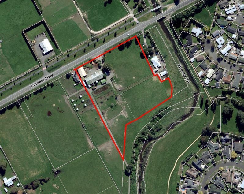
CONTENTS

Part I – Description of the Proposed Plan Change
Part II – Section 32 Report
Appendix 1 – Proposed Plan Change C Amendments to the District Plan
Appendix 2 – Landscape Assessment
Appendix 3 – Transportation Assessment & Adendum
Appendix 4 – Stormwater Infrastructure Assessment
Appendix 5 - Water & Wastewater Infrastructure Assessment
Appendix 6 – Liquefaction Assessment
Appendix 7 – Noise Assessment
Appendix 8 – Soils Assessment
Proposed Plan Change C: Kakatangiata – Stage 1 Kikiwhenua Residential Area                  Section 32 Report

Part I - Proposed Plan Change

1       Description of the Proposed Plan Change

        Proposed Plan Change C (PC C) involves:

            1. The rezoning of approximately 24ha of Race Training Zone land to Residential Zone to
               establish the Kikiwhenua Residential Area. This area forms part of the wider Kakatangiata
               Growth Area (formerly City West) identified in the Palmerston North City Development
               Strategy (2017) as a preferred residential growth area.

            2. The repurposing of District Plan Section 7A Whakarongo Residential Area to be the framework
               for all new greenfield areas including the proposed Kikiwhenua Residential Area.

        The Kikiwhenua Residential Area refers to the land bounded by Pioneer Highway, Te Wanaka Road,
        and the Mangaone Stream. This area is considered Stage 1 of the wider Kakatangiata Growth Area,
        bounded by No 1 Line, Longburn Rongotea Road/Shirriffs Road, and the Mangaone Stream.
        Kakatangiata is the formalised name for the previous City West Growth Area.

        The name Kakatangiata has been chosen by Rangitāne o Manawatū through researching old maps
        for the area. The name translates to “Kaka welcoming the morning”.

        With the introduction of specific provisions in the Subdivision and Residential Zone sections of the
        District Plan. Some new provisions are recommended to address the site-specific design requirements
        for subdivision and development in this area, recognising the significant historic relationship Rangitāne
        o Manawatū have with this site and natural hazard and stormwater constraints.

        The following is the proposed Kikiwhenua Residential Area Structure Plan:

                                                       1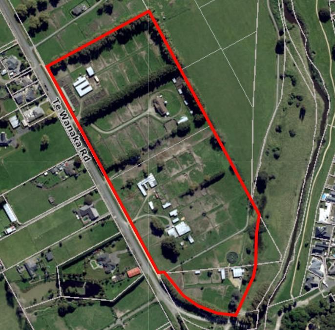
Proposed Plan Change C: Kakatangiata – Stage 1 Kikiwhenua Residential Area   Section 32 Report

                                 Figure 2: Kikiwhenua Residential Area

                                                       2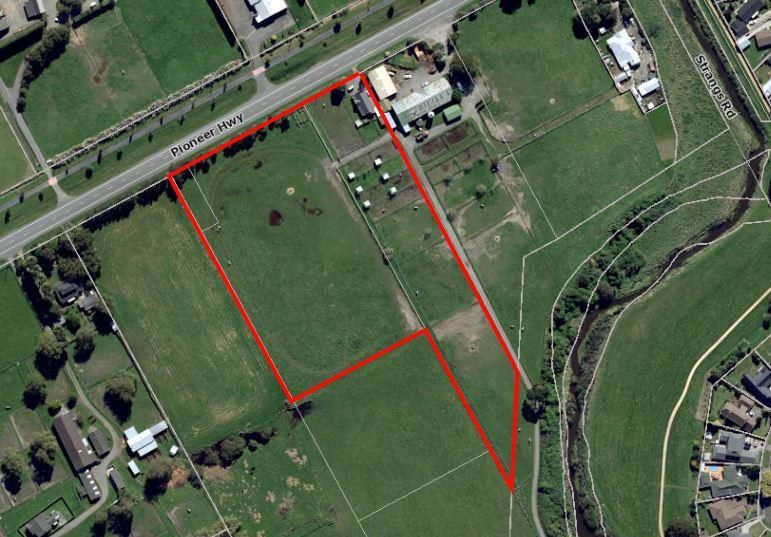
Proposed Plan Change C: Kakatangiata – Stage 1 Kikiwhenua Residential Area   Section 32 Report

                                                       1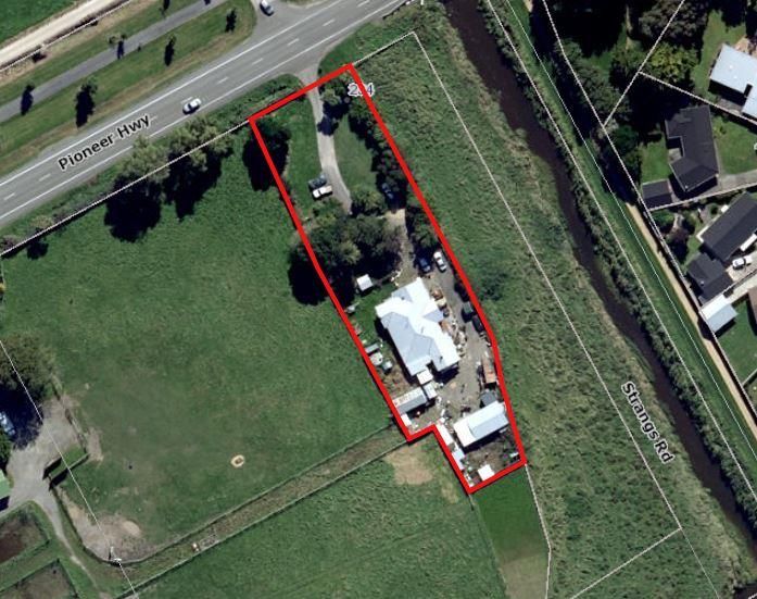
Proposed Plan Change C: Kakatangiata – Stage 1 Kikiwhenua Residential Area                Section 32 Report

2       Proposed amendments to the District Plan

District Plan Provisions

        Refer to Appendix 1 for all amendments proposed to the Definitions, Whakarongo Resdiential Area,
        and Residential Zone Sections. The proposed Kikiwhenua Structure Plan is also included in Appendix
        1.

Planning Maps

        1. Amend Planning Maps 24 and 30 by rezoning the land from Race Training Zone to Residential
           Zone. The land parcels affected by rezoning are shown in red in the following table:

                                                                              Property Address
                              Aerial
                                                                                 Legal Title

                                                                    154 Pioneer Highway

                                                                    LOT 1 DP 32600 BLKS XIV KAIRANGA
                                                                    SD

                                                                    Part of lot 61-99 Te Wanaka Road

                                                                    LOTS 2 3 DP 32600 BLK XIV

                                                                    Part of lot 149 Te Wanaka Road

                                                                    LOT 1 DP 493470

                                                       1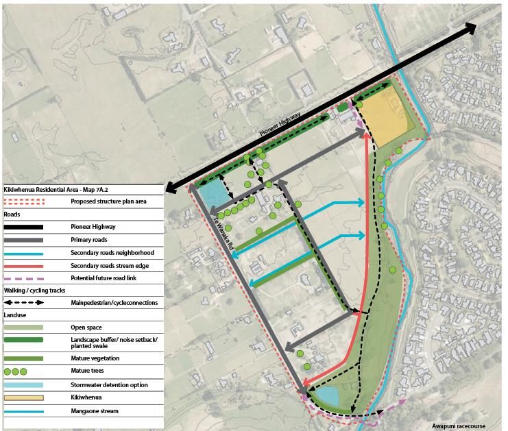
Proposed Plan Change C: Kakatangiata – Stage 1 Kikiwhenua Residential Area                Section 32 Report

                                                                    Pioneer Highway

                                                                    PT RS 361 BLKS X XIV KAIRANGA SD

                                                                    Part of lot 214 Pioneer Highway

                                                                    RURAL SECS 361A 361B PT SEC 361
                                                                    PT LOT 1 DP 8529 BLK X KAIRANGA
                                                                    SD

                                                       2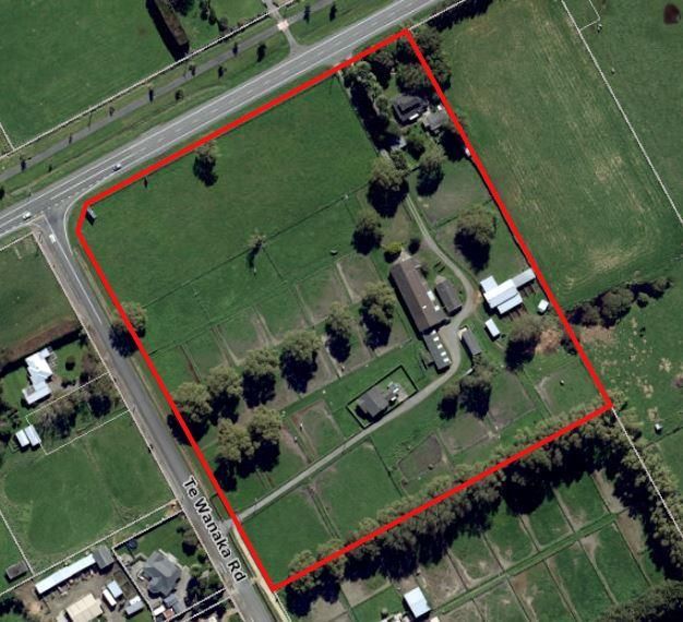
Proposed Plan Change C: Kakatangiata – Stage 1 Kikiwhenua Residential Area                Section 32 Report

                                                                    234 Pioneer Highway

                                                                    LOT 1 DP 80929 BLK X KAIRANGA SD

                                                                    Part of lot 214 Pioneer Highway

                                                                    RURAL SECS 361A 361B PT SEC 361
                                                                    PT LOT 1 DP 8529 BLK X KAIRANGA
                                                                    SD

   Consequential Changes

        1. Make consequential changes, including numbering changes, as a result of the insertion of new
           rules, as necessary.

                                                       3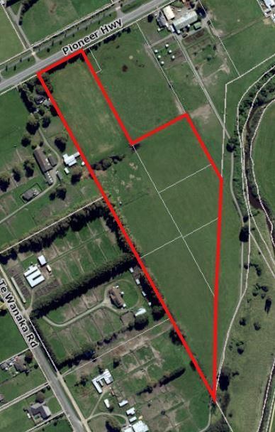
Proposed Plan Change C: Kakatangiata – Stage 1 Kikiwhenua Residential Area             Section 32 Report

Part II - Section 32 Report

1       INTRODUCTION

1.1     This report provides a summary of the evaluation undertaken by the Palmerston North City Council
        (the Council) in accordance with Section 32 of the Resource Management Act 1991 (RMA or the Act)
        in relation to Proposed Plan Change C: Kakatangiata – Stage 1: Kikiwhenua Residential Area (PC C)
        to the operative Palmerston North City District Plan (the District Plan or the Plan).

1.2     The report should be read in conjunction with the proposed amendments to the District Plan in
        Appendix 1 of this report, and the accompanying expert reports and research supporting the proposed
        plan change, Appendices 2 – 8.

1.3     This report is structured in six parts:

        Part 1: Introduction
                The purpose of Proposed Plan Change C
                An overview of the approach to the Sectional District Plan Review
                An overview of the District Plan requirements under the Resource Management Act 1991
                Background to Proposed Plan Change C

        Part 2: Regulatory and Policy Context
                Current District Plan approach
                Proposed changes to the District Plan
                Supporting documents and expert reports
                Record of consultation on proposed plan change

        Part 3: Evaluation of Alternatives and the Preferred Option
                Examining whether the proposed plan change is the most appropriate way to achieve the
                purpose of the Resource Management Act 1991

        Part 4: Implementation of Preferred Option: Objectives, Policies and Rules
                Examining the appropriateness of proposed objectives, policies and methods
                Analysis of land proposed to be rezoned to Residential Zone

        Part 5: Statutory Evaluation and Summary

        List of Abbreviations

1.4     The following is a list of abbreviations referred to throughout the report:

        •   PC C – Proposed Plan Change C: Kakatangiata
        •   Kakatangiata – Former City West Residential Growth Area
        •   RoM – Rangitāne o Manawatū
        •   RMA or the Act – Resource Management Act 1991
        •   The Council or PNCC – Palmerston North City Council
        •   The District Plan – Palmerston North City District Plan
        •   PPC20A – Proposed Plan Change 20A: Residential Zone and Residential Subdivision
        •   WRA – Whakarongo Residential Area
        •   KRA – Kikiwhenua Residential Area

                                                        4
Proposed Plan Change C: Kakatangiata – Stage 1 Kikiwhenua Residential Area Section 32 Report
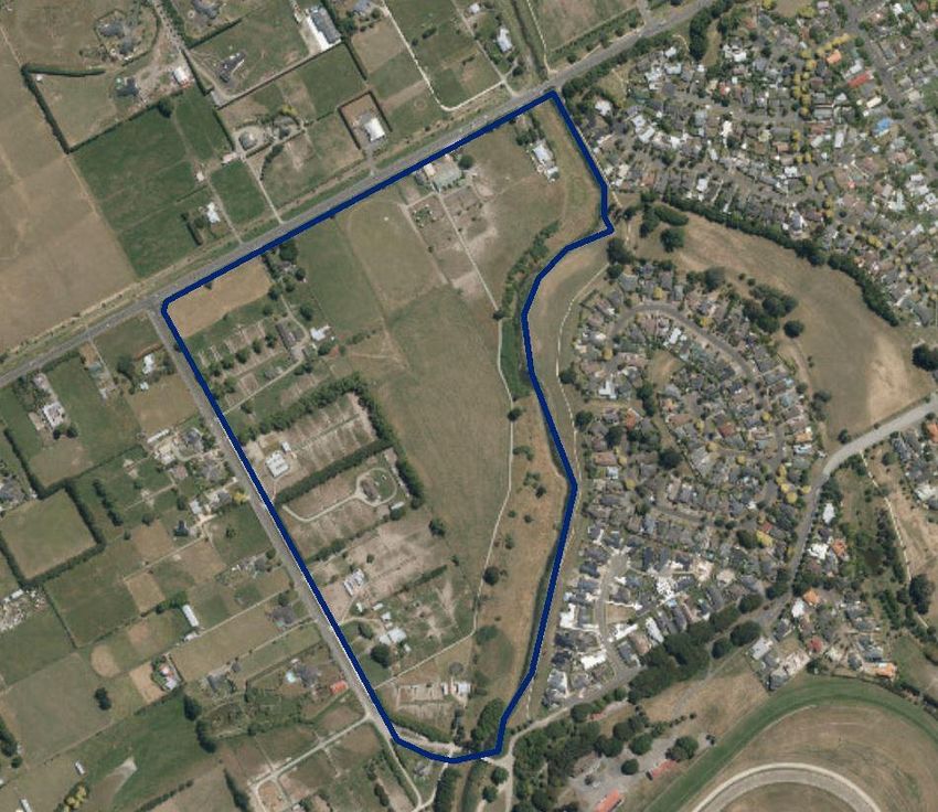
The Purpose of PC C
1.5 The primary purpose of PC C is to rezone land between the eastern boundary of Te Wanaka Road,
the western boundary of the Mangaone Stream, and the southern boundary of Pioneer Highway, from
Race Training Zone to Residential Zone, and introduce new provisions in the District Plan to manage
residential development of the site. The rezoning involves approximately 23.6 ha of land, and the
creation of approximately 220 residential lots. The property at 234 Pioneer Highway is also included
for rezoning to residential to maintain a contiguous Residential Zone.
Figure 2: Proposed Plan Change C Scope
1.6 The scope of PC C is restricted to this area of land for the following reasons:
a. The identified area has been signalled in PNCC’s Asset Management Plans as stage one
for the development of the wider Kakatangiata Growth Area.
b. The area is able to be serviced independently of other parts of the wider Kakatangiata
Growth Area.
5Proposed Plan Change C: Kakatangiata – Stage 1 Kikiwhenua Residential Area Section 32 Report
c. The area is the closest site to the established urban boundary, so forms a continuation of
the existing residential environment.
d. The area has a discrete number of landowners to develop a structure plan with, enabling
for land to be released for housing faster than conducting a structure plan and plan change
preparation for a larger area.
e. The land area is no longer required for horse training activities.
f. The Te Wanaka Road corridor provides a buffer between horse training and residential
land use to avoid noise sensitivity effects.
1.7 The rezoning proposal is accompanied by a structure plan and set of District Plan objectives, policies,
and rules that will inform subdivision and development in the Kikiwhenua Residential Area. The
recommended approach is to adopt the operative District Plan Section 7A Whakarongo Residential
Area objectives, policies and rules and repurpose these as generic greenfield provisions. This
approach will form the basis for all new future greenfield residential sites across the District.
Statutory Requirements under the RMA
1.8 The Purpose of the RMA – The purpose of the RMA is to promote the sustainable management of
natural and physical resources. Section 5(2) of the Act states:
“In this Act, sustainable management means managing the use, development, and protection of
natural and physical resources in a way, or at a rate, which enable people and communities to provide
for their social, economic, and cultural wellbeing and for their health and safety while –
a. Sustaining the potential of natural and physical resources (excluding minerals) to meet the
reasonably foreseeable needs of future generations; and
b. Safeguarding the life-supporting capacity of air, water, soil, and ecosystems; and
c. Avoiding, remedying, or mitigating any adverse effects of activities on the environment.”
1.9 Section 32 of the RMA – The 2013 Resource Management Act amendments have altered the
requirements under section 32 of the RMA which now states:
“(1) An evaluation report required under this Act must -
(a) examine the extent to which the objectives of the proposal being evaluated are the
most appropriate way to achieve the purpose of this Act; and
(b) examine whether the provisions in the proposal are the most appropriate way to
achieve the objectives by -
(i) identifying other reasonably practicable options for achieving the objectives;
and
(ii) assessing the efficiency and effectiveness of the provisions in achieving the
objectives; and
(iii) summarising the reasons for deciding on the provisions; and
(c) contain a level of detail that corresponds to the scale and significance of the
environmental, economic, social, and cultural effects that are anticipated from the
implementation of the proposal.
6Proposed Plan Change C: Kakatangiata – Stage 1 Kikiwhenua Residential Area Section 32 Report
(2) An assessment under subsection (1)(b)(ii) must -
(a) identify and assess the benefits and costs of the environmental, economic, social, and
cultural effects that are anticipated from the implementation of the provisions,
including the opportunities for -
(i) economic growth that are anticipated to be provided or reduced; and
(ii) employment that are anticipated to be provided or reduced; and
(b) if practicable, quantify the benefits and costs referred to in paragraph (a); and
(c) assess the risk of acting or not acting if there is uncertain or insufficient information
about the subject matter of the provisions.
…
(5) The person who must have particular regard to the evaluation report must make the report
available for public inspection -
(a) as soon as practicable after the proposal is made (in the case of a standard or
regulation); or
(b) at the same time as the proposal is publicly notified.
(6) In this section, objectives means -
(a) for a proposal that contains or states objectives, those objectives:
(b) for all other proposals, the purpose of the proposal
proposal means a proposed standard, statement, regulation, plan, or change for which an
evaluation report must be prepared under this Act.
provisions means -
(a) for a proposed plan or change, the policies, rules, or other methods that implement,
or give effect to, the objectives of the proposed plan or change;
(b) for all other proposals, the policies or provisions of the proposal that implement, or
give effect to, the objectives of the proposal.”
1.10 Section 32 stipulates the content and evaluation is necessary prior to notification. The evaluation
report focuses only on those parts of the District Plan where changes are being proposed. In this
instance, the provisions are all new to the site that is being rezoned. On that basis a full assessment
is included in this report.
1.11 Section 32AA requires Council to undertake a further evaluation if any further changes are proposed
prior to making a decision on a plan change, for example, in response to submissions received. This
further evaluation must be cited at any subsequent hearing.
1.12 Functions of District Councils – The Council has statutory functions under section 31 of the RMA,
which include the establishment, implementation, and review of objectives, polices and methods to
achieve integrated management of the effects of the use, development, or protection of land and
associated natural and physical resources of the district.
1.13 The Purpose of District Plans – The purpose of a district plan under section 72 of the RMA is to
assist territorial authorities to carry out their functions in order to achieve the purpose of the Act.
7Proposed Plan Change C: Kakatangiata – Stage 1 Kikiwhenua Residential Area Section 32 Report
1.14 Preparation of District Plans – Section 73 states that there must be at all times one district plan for
each district prepared by the Council in a manner set out in the First Schedule of the Act.
1.15 Matters to be Considered by Territorial Authorities – The matters to be considered by a district
council when preparing or changing its district plan are set out in section 74 of the Act. This requires
councils to act in accordance with its functions under section 31, the provisions of Part 2, and its duty
under section 32. Section 74(2) also sets out a number of other matters Council shall have regard to
including plans and strategies prepared under other acts. Importantly, section 74(3) states that when
preparing a change to a district plan a territorial authority must not have regard to trade competition.
Background and Historical Land Use within the PC C Area
1.16 Pre-European Occupation
Rangitāne o Manawatū have ties with the land at the Awapuni Lagoon for over 800 years and this area
forms part of their rohe. Awapuni served as a reliable food source. The karaka grove that lies at the
northwestern edge of the Awapuni Racecourse is the last remaining remnant of the Awapuni Lagoon
Karaka forest. A number of kainga (unfortified villages) settled nearby this resource, as evidenced by
the number of archaeological finds that have been previously unearthed through residential
development around the Maxwells Line area.
1.17 Pre-Racecourse Occupation
After Europeans had settled in New Zealand, the land around the Awapuni Lagoon was eventually
sold and cleared for settlement by Scandinavian immigrants. 105 acres was subsequently purchased
back by some Rangitāne to re-establish a kainga and marae named after Awapuni. A meeting house
was built in 1883 at Awapuni marae to commemorate the first visit of the Maori King to the Manawatū.
European river engineering and drainage works had seen the natural landscape of the Awapuni
Lagoon change to release land for agriculture at the sacrifice of the natural eel and karaka resources.
Remnants of the Awapuni Lagoon still currently exist as Otira Park, Rangitāne Park, and parts of the
Mangaone Stream.
1.18 Post-Racecourse Context
The Awapuni Racecourse was established on its current site in 1903. Agriculture and racehorse
training activities had persisted on the Awapuni Lagoon site until residential growth had reached
Maxwells Line and led to the successive subdivision of land up to the bounds of the Awapuni
Racecourse and Mangaone Stream. In 1925 Kikiwhenua was destroyed in a fire, and the land
eventually sold in 1938. A number of known and unknown Pa and Urupa sites have been unearthed
through the subdivision of land in the area. Two local sites have been restored to Rangitāne ownership:
Te Hotu Manawa O Rangitāne, the location of a former kainga and battleground, and a site on the
embankment of the Mangaone Stream that forms part of the Crown settlement with Rangitāne o
Manawatu. The plan change area currently exists as racehorse training land. This land is considered
to be surplus to requirements with the racehorse capacity that can be provided for at the Awapuni
Racecourse itself and on RACE Inc’s partner facility Kamada Park at the south of Te Wanaka Road.
Apart from a few stables and trainer accommodation, the site remains relatively undisturbed since the
site was originally cleared.
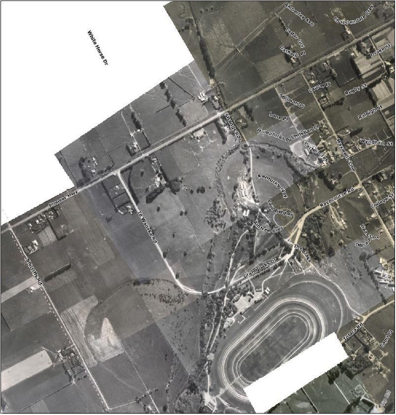
8Proposed Plan Change C: Kakatangiata – Stage 1 Kikiwhenua Residential Area Section 32 Report
Figure 3: Te Wanaka Road and Awapuni in 1956 showing agricultural land use on Te Wanaka
Road, with race training facilities located where current residential land use around Caufield
Place now stands.
Existing planning provisions for the Kikiwhenua Residential Area
1.19 The site is currently zoned Race Training. The Race Training Zone was most recently reviewed as
part of the Sectional District Plan Review between 2015/2016. At the time of the review of the Race
Training Zone, residential zoning for Te Wanaka Road was considered out of scope due to the
following reasons:
9Proposed Plan Change C: Kakatangiata – Stage 1 Kikiwhenua Residential Area Section 32 Report
a. The primary purpose of Plan Change 21 was to review existing land use provisions in the
Recreation Zones. The Race Training Zone was only included in that review due to its
association with the Racecourse Zone
b. Rezoning land at the scale of the Race Training Zone required an informed structure plan
and technical investigations which had not occured.
1.20 The Race Training Zone Memorandum in Plan Change 21 recommended that retaining the zone extent
with a minor rezone of Kamada Park’s expansion provides for race training needs in the short to
medium term. Long term investment would see consolidated race training facilities developed by
Kamada Park and on site at the Awapuni Racecourse. Aside from Kamada Park, no one else in the
Zone has been investing further into race training facilities. Below is the key observation from the land
use survey conducted in 2015:
72 percent of the Race Training Zone is currently used for race training purposes. Some of these sites
are inactive or used inefficiently. The current demand for race training along Te Wanaka Road is limited
due to the following:
• The dispersal of racecourses across the Manawatu and Wellington regions, stretching the demand
for race training across a series of smaller catchments.
• The maintenance requirements of the track at Awapuni Racecourse limiting the amount of race days
that can be accommodated locally.
1.21 The provisions of the zone are largely permissive in nature and provide for activities ancillary to the
horse racing industry. Other activities wishing to establish in the zone are a Discretionary Activity.
1.22 Pre-existing residential land use is provided for as a permitted activity, but new residential buildings
and subdivision is discouraged to manage reverse sensitivity effects on race training and agistment
activities that:
a. Predominantly operate earlier in the morning than residential activities;
b. House noise sensitive activities; and
c. Require horse cartage and riding to and from the Racecourse in a safe manner.
2 REGULATORY AND POLICY CONTEXT
Current District Plan Framework
2.1 Section 2: City View Resource Management Issues and Objectives – The overarching resource
management issues and objectives for the City are outlined under section 2 of the District Plan. These
Issues and Objectives establish the intent of the Plan at the strategic level. The strategic approach set
out by the City View section provides a basis and direction for the identification of lower level and more
specific resource management issues, objectives, polices and methods for the specific zones in the
District Plan.
2.2 The City View Issues and Objectives were reviewed and updated as part of Plan Change 8. The City
View Objectives that are directly applicable to the Race Training and Residential Zone highlight:
10Proposed Plan Change C: Kakatangiata – Stage 1 Kikiwhenua Residential Area Section 32 Report
1. Planning for residential, industrial, commercial and rural-residential growth sustains a
compact, orderly and connected urban form which avoids the adverse environmental effects
of uncontained urban expansion into the rural zone.
2. The provision of infrastructure, particularly within identified growth areas, shall be efficient,
timely, environmentally sensitive and economically sustainable.
3. The integrated and efficient provision of, and access to, infrastructure, network utilities and
local services is facilitated for all residents.
5. A variety of high quality residential living environments are provided to satisfy the needs of all
residents.
6. Rural subdivision and development is directed away from Class I and II versatile soils.
7. The infrastructural demands of rural subdivision and development are minimised.
8. The distinctive rural and urban character of the City is recognised and a clear differentiation
is provided regarding subdivision, development and servicing expectations within rural and
urban areas.
9. Subdivisions, buildings and infrastructure are designed and constructed to promote a
coordinated, healthy and safe environment.
10. The visual appeal of the City is enhanced.
11. The principles of good urban design are given effect to for all new subdivisions, urban
intensification and major building developments, particularly those located within the City
Centre or fronting key transportation routes.
13. Investment within the City is stimulated and identified priority sectors such as research,
education, public administration, retail, logistics, construction, manufacturing and agriculture
are well supported.
15. Active engagement from tangata whenua within resource management decisions.
16. The historic heritage of the City is researched, identified and preserved within the context of
sustainable management.
17. The natural and cultural heritage features of the City are preserved and enhanced, including
the margins of the Manawatū River and sites of significance to tangata whenua.
19. The effects of natural hazards are avoided or mitigated taking into account the effects of
climate change and the significant social disruption caused by natural hazard events.
22. Appropriate noise standards are in place to protect noise sensitive activities.
23. Infrastructure operates in a safe and efficient manner, and the effects of activities which could
impact on the safe and efficient operation of this infrastructure are avoided, remedied or
mitigated.
24. All forms of transport, including public transport, walking, cycling and private vehicles are
adequately provided for to assist with sustainable energy use and a healthy lifestyle.
11Proposed Plan Change C: Kakatangiata – Stage 1 Kikiwhenua Residential Area Section 32 Report
2.3 Section 21: Race Training Zone – The existing Race Training Zone Chapter of the District Plan seeks
to reflect the character and needs of activities within the zone and in particular limit the reverse
sensitivity effects that race training activities can create through the early training and movement of
horses on a daily basis.
2.4 This purpose is mainly achieved through the dedication of all land adjacent to Te Wanaka Road for
race training activities to avoid the development of activities that may not be complimentary. The Race
Training Zone includes noise rules similar to the Rural Zone, Permitted Activity status for race horse
stabling, training, associated accommodation and veterinary clinics, and Discretionary Activity status
for new residential buildings, which all contribute towards maintaining an environment that prioritises
racecourse activities along Te Wanaka Road.
2.5 Section 10: Residential Zone – The outcome of the Plan Change 20: Residential Zone review
established the overarching approach to residential development. This included objectives around
using existing residential land efficiently to avoid unnecessary sprawl and maintain the look and feel
of residential areas. The Zone enables a variety of housing choices, protects street character when
redevelopment happens, and contains goals for a more sustainable and resilient city.
2.6 Dwellings, accessory buildings, and minor dwelling units are permitted activities in the Residential
Zone. Those activities which cannot meet performance standards, multi-unit residential development,
and activities within the Awatea Stream and Jensen Street Ponding areas are restricted discretionary
activities. Dwellings in Savage Crescent, changes to existing buildings in the Air Noise Contour, and
domestic wind turbines are Discretionary Activities. Non-Complying Activities include those that do not
meet provisions in the plan, dwellings in the Inner and Outer Control Contours, roading infrastructure
in the Napier Road Residential Area, and external storage of derelict vehicles. Prohibited Activities are
new dwellings, sleep outs, relocated houses and minor dwelling units in the Air Noise Zone.
2.7 The Residential Zone also enables a number of non-residential activities such as community houses,
accommodation motels, education facilities, health facilities, home occupations, structural
maintenance of flood protection works, and temporary military training activities.
2.8 Plan Change 23, Hokowhitu Lagoon Residential Area, sought to enable development of the former
Massey University Teacher’s College brownfield site. Plan Change 23 posed similar cultural and
stormwater management issues as PC C.
2.9 Section 7A: Whakarongo Residential Area – Plan Change 6: Whakarongo Residential Area sought
to rezone land to the east of the city signalled as one of the Council’s preferred areas for residential
growth under the Palmerston North City Residential Growth Strategy 2010. Section 7A enabled
greenfield development within this growth area under the guidance of a structure plan.
2.10 The Whakarongo Residential Area provides a framework which the Council can be a model for PC C
and future greenfield residential options. The key intention for this approach is to ensure that
development in these greenfield areas is coordinated in aspects of natural hazards mitigation,
connectivity, infrastructure provision, and design quality.
Proposed Changes to the District Plan
2.11 PC C involves the rezoning of the site identified as the Kikiwhenua Residential Area from Race Training
to Residential Zone. Changes are proposed to specifically provide for the residential subdivision of the
site via the Greenfield Residential Area Chapter (Formerly Whakarongo Residential Area), residential
development via the Residential Zone Section. Consequential changes are proposed for the Race
Training Zone. A structure plan to inform subdivision and development is also proposed.
12Proposed Plan Change C: Kakatangiata – Stage 1 Kikiwhenua Residential Area Section 32 Report
2.12 Subdivision rules for the Whakarongo Residential Area have been generalised to apply to both the
Whakarongo and Kikiwhenua Residential Areas. Where provisions specifically relate to the
Whakarongo Residential Area exclusively, these have been separated out to avoid conflict with other
Greenfield Residential Areas. The Plan Change proposes no substantive amendments to the planning
framework for Whakarongo; these amendments are administrative in nature.
2.13 Subdivision in the Kikiwhenua Residential Area is proposed to be provided for under the following
framework:
2.14 Any Greenfield Residential Area shall be assessed as a Restricted Discretionary Activity, where
discretion is restricted to matters such as those currently used for the Whakarongo Residential Area.
2.15 For site-specific resource management issues, performance standards and assessment criteria have
been explicitly provided for the Kikiwhenua Residential Area. These issues broadly relate to:
• Water sensitive design requirements
• Archaeological assessment and cultural monitoring
• Subdivision layout and design with respect to recognising the connections between Rangitāne
and significant land and water sites
• The integration of existing mature vegetation
• Legibility
• Connections to nearby pedestrian and cycle networks
2.16 The above provisions are guided by a new policy specific to the Kikiwhenua Residential Area.
2.17 Underpinning the specific provisions for the Kikiwhenua Residential Area are the following resource
management issues
Resource Management Issues:
• The effects of residential development on sites of significance to Rangitāne
• The effects of residential development on stormwater quantity and quality
2.18 Some Greenfield Residential Area provisions have had editorial changes made to keep the
terminology up to date with recent plan changes, or to help interpretation. These changes have been
worded to avoid altering the meaning of the provision, and have no substantive impact on the planning
framework for the Whakarongo Residential Area.
2.19 A copy of the full Subdivision section S7A of the District Plan with all proposed changes, and excerpts
from the Residential and Definitions sections is included in Appendix 1.
13Proposed Plan Change C: Kakatangiata – Stage 1 Kikiwhenua Residential Area Section 32 Report
Chronology
2.20 The following outlines the key milestones in preparing the Proposed Plan Change to date:
December 2017 Meeting with Horizons Regional Council and PNCC asset managers
regarding stormwater and flood constraints to the plan change area.
February 2018 Workshop with RACE Inc, Kamind Properties Ltd, and PNCC asset
managers to introduce the plan change investigation.
March 2018 Meeting with Rangitāne to introduce plan change investigation and engage
Tanenuiarangi o Manawatū for cultural impact advice.
Technical experts engaged for PC C.
May 2018 Workshop with RACE Inc, Tanenuiarangi o Manawatū, PNCC asset
managers, and technical experts to feed into structure planning exercise for
the plan change.
June 2018 City Development Strategy adopted by Council, including the direction to
rezone the Kikiwhenua Residential Area for residential housing.
Meeting with Horizons Regional Council to further discuss PC C.
July 2018 Meeting with Rangitāne and RACE Inc. to discuss the draft Kikiwhenua
Structure Plan.
Meeting with NZTA to discuss the draft Kikiwhenua Structure Plan.
August 2018 Memorandum of Partnership (MoP) signed between RACE Incorporated and
RoM to set out how the two parties will work together throughout the
development of the Kikiwhenua Resiential Area. This MoP addresses
components of Table 4 below.
October 2018 Section 32 Planning Assessment Report and draft provisions presented to
the PNCC Planning and Strategy Committee.
Consultation with key stakeholders
2.21 A number of meetings have been held with key stakeholders during the preparation of the Plan
Change. The key stakeholder meetings are identified in the Chronology above.
2.22 Section 3B of the Act requires local authorities to consult with iwi authorities in the following ways:
• Establish and maintain processes to provide opportunities for iwi authorities to be consulted.
• Enable iwi authorities to identify resource management issues of concern to them.
• Indicate how those issues have been or are to be addressed.
2.23 Council has met the above obligations through the following:
• Consultation and workshops described in the chronology above.
14Proposed Plan Change C: Kakatangiata – Stage 1 Kikiwhenua Residential Area Section 32 Report
• Engagement with Tanenuiarangi o Manawatū Incorporated to conduct a Cultural Impact
Assessment which has identified key resource management issues significant to Rangitāne o
Manawatū.
• A planning assessment of the appropriate delivery mechanisms for achieving recommended
outcomes in the Cultural Impact Assessment.
2.24 In summary feedback from parties has indicated that:
a) Rangitāne o Manwatū – Feedback from RoM is predominantly covered under the response to the
Landscape Assessment and Cultural Impact Assessment in Part 2 of this report.
b) RACE Incorporated and Kamind Properties Ltd – Both parties with landowner interest in the site
and their consultants have been consulted throughout the process and most of the Structure Plan
decisions proposed have been communicated with these parties. It is expected that any further
feedback can be accommodated in the submissions stage.
c) Horizons Regional Council - No substantial flood hazard risks have been raised. If further
information becomes available at the time of notification then PC C will be able to address these
through the response to submissions.
d) New Zealand Transport Agency (NZTA) – The main concerns raised by NZTA are:
a. Limiting individual accesses onto Pioneer Highway
b. The safe and efficient operation of the road network with respect to the junction of Te
Wanaka Road and Pioneer Highway
c. Noise sensitivity in the proximity of Pioneer Highway
Supporting evidence
2.25 In considering and preparing PC C the Council commissioned relevant technical reports and
supporting documents. These included:
1. Landscape Assessment
2. Transportation Assessment
3. Stormwater Assessment
4. Water & Wastewater Assessment
5. Cultural Impact Assessment
6. Liquefaction Assessment
7. Noise Assessment
8. Soil Assessment
2.26 The key findings of these reports are outlined below.
15Proposed Plan Change C: Kakatangiata – Stage 1 Kikiwhenua Residential Area Section 32 Report
Landscape Assessment, Isthmus, September 2018
2.27 Council commissioned Isthmus Group to conduct a Landscape Assessment, draft the proposed
Kikiwhenua Structure Plan (Map 7A.2), and provide urban design and landscape advice with respect
to how the Whakarongo Residential Area provisions would perform for the Kikiwhenua Residential
Area.
2.28 The Landscape Assessment determined that the proposed Kikiwhenua Residential Area will result in
a fundamental change in landscape character, however given the peri-urban context of the site,
rezoning will be appropriate.
2.29 The Landscape Assessment noted that the Whakarongo Residential Area provisions lack detail on
how to implement policies related to urban design, and the Residential Zone development provisions
do not address finer grain design matters that contribute to the character of the neighbourhood.
2.30 Isthmus recommended two options of Structure Plan based on a workshop exercise conducted with
Transport Engineering, Landscape Architecture and Urban Design, Acoustic Engineering, Rangitāne,
and Planning input contributing. One option (Option A) provided for a road connection towards the
terraced edge of the Mangaone Stream, and the other (Option B) provided for a road connection
running along the legal boundary of RACE’s land.
2.31 Structure Plan Option A has been accepted for inclusion in the District Plan with the following changes:
• Removal of Pocket Parks and Small Open Spaces:
The retention of Kikiwhenua will likely require investment above what has been planned in the
Asset Management Plans for parks and community facilities. The combination of amenity and
open space to be created through stormwater detention ponds, Kikiwhenua, and the
Mangaone Stream edge is considered to provide sufficient parkland and open space for the
Kikiwhenua Residenital Area without the need for additional pocket parks and small open
spaces.
• Formalise the Boundary of Kikiwhenua:
On agreement between RACE and Rangitāne, the boundary of Kikiwhenua has been
confirmed to the area denoted on the proposed Kikiwhenua Structure Plan. In the future this
may necessitate the possible purchase of 234 Pioneer Highway to create a clear connection
between the Mangaone Stream and Kikiwhenua, and avoid a parcel of residential land use
not contiguous with the rest of the Residential Zone.
• Removal of the Possible Community/Commercial Centre (Repurposed Barn):
For reasons below in Figure 3, the repurposed barn/community centre is not considered viable
at this stage of the development of Kakatangiata.
• Removal of Further Internal Tracks:
With block lengths on average approximately 200m, the further internal track will provide a
higher level of connectivity than is considered necessary throughout the site. With no
community or commercial centre included, there is no intended destination to warrant the
further internal track.
16Proposed Plan Change C: Kakatangiata – Stage 1 Kikiwhenua Residential Area Section 32 Report
• Shift one of the Pedestrian Connections to Pioneer Highway:
The second pedestrian connection along Pioneer Highway from the west has been located to
provide a clear connection from the adjacent primary road, however in the principle of retaining
mature vegetation it is considered more appropriate to agglomerate the pedestrian connection
with an existing stand of Phoenix Palm trees.
• Inclusion of a Forked Pedestrian Connection to the South of the Site:
The site will in the future connect to the Awapuni Racecourse and Manawatū Bridle Track to
the south, and oxbow remnant to the southwest. Clear and logical pedestrian and cycle
connections to these networks is important.
• Reorientate the Northern Pedestrian Connection from the east of Kikiwhenua to the
west of Kikiwhenua:
In consultation with Rangitāne it is considered to be more culturally appropriate to reorientate
the streamside pedestrian connection around the west of Kikiwhenua.
• Identify the Connection to Grand Oaks Drive and the Eastern Access to Pioneer
Highway as “Possible Future Road Connection”
These connections are not warranted yet, as described in the Transport Assessment, however
it is useful to retain these on the Structure Plan to communicate Council’s future intentions. In
the immediate term these connections would remain as pedestrian and cycle connections.
2.32 The following is an outline of the recommendations and the appropriate policy response to these:
Table 1: Planning Assessment of Landscape Recommendations
Landscape and Urban Design
Planning Recommendation
Recommendation
Investigate the feasibility of • Structure Plan road alignment to incorporate treed areas
retaining mature trees and
1 shelterbelts for incorporation as • Subdivision assessment criteria to assess how well the
amenity planting alongside development retains mature trees
roads
Investigate the feasibility of • This has not been included in the Structure Plan for the
repurposing the historic barn, for following reasons:
possible use as a café as part of
the Te Wanaka Residential Area o There are no District Plan protections over the barn
community centre
2 o Demand for a new community/commercial centre
would be limited given this is the first stage of
Kakatangiata
o Commercial services are likely to be developed at
520 Pioneer Highway which may meet new demand
Amend District Plan Section 7A: • Plan Change C as proposed
3
Whakarongo Residential Area to
incorporate provisions specific
17Proposed Plan Change C: Kakatangiata – Stage 1 Kikiwhenua Residential Area Section 32 Report
to Te Wanaka Residential Area
(as set out in this report), for re-
purpose as part of the Structure
Plan
Develop Design Guidelines, and • This recommendation has not been recommended in PC C
attach those as an appendix to because the Structure Plan and associated provisions are
the District Plan considered appropriate for prescribing the key outcomes
4 sought from the development whilst providing the flexibility
for how those outcomes are delivered
Addition of Objectives and • Subdivision performance standards requiring an urban
Policies to address Sense of design statement to demonstrate how the development
place/identity (investigation into contributes to a sense of place
retention/re-purpose of suitable
existing heritage features such • Subdivision assessment criteria related to tree retention
5 as buildings associated with
current racing uses and mature • The contribution of street naming to a sense of place would
trees; response to existing be expected to be developed through the Memorandum of
racing uses e.g. through street Partnership between RACE and Rangitāne o Manawatū
naming)
Addition of Objectives and • Memorandum of Partnership between RACE and Rangitāne
Policies to address Kikiwhenua o Manawatū
cultural expression (this will be
dependent on consultation with • Subdivision assessment criteria
Rangitaane on appropriate use
6
of the area. There is opportunity • Reserve development planning outside of this process
for development of partnership
between Racing Incorporated –
the current land-owner, and
Rangitaane)
Addition of Objectives and • Structure Plan
Policies to address
Development of a strong • Subdivision assessment criteria
7
relationship with the Mangaone
Stream • Memorandum of Partnership between RACE and Rangitāne
o Manawatū
Description within the provisions • This is anticipated to be addressed at the Comprehensive
of anticipated outcomes at Development Plan level as part of the subdivision stage
different areas/zones within the
Structure Plan, such as the area
8 along Mangaone
Stream/escarpment (where lot
size and built form may reflect
opportunities for increased
yield); the area facing Te
Wanaka Road (which should
18Proposed Plan Change C: Kakatangiata – Stage 1 Kikiwhenua Residential Area Section 32 Report
follow a layout which allows for
further development should the
current high-speed environment
change); the Community Centre
area, and the area facing
Pioneer Highway
Identification within the • Structure Plan
Structure Plan of hierarchy
9
layout for both primary and • Subdivision assessment criteria to require a clear hierarchy
secondary roads of roads
Inclusion of prescriptive • The resource consent design review process is anticipated to
performance conditions related help determine road design to deliver on the road hierarchy
to street hierarchy (minimum
widths of primary and secondary
roads), together with illustrative
guidance on use of tertiary
roads
Guidance on possible layout of • The resource consent design review process is anticipated to
lots in relation to streets for help advise on logical and functional lot layouts
10
maximised functionality, value
and site responsiveness
Guidance on built form, • Council’s design review process and Delivering Change
materials, and relationship programme will be able to influence these matters without
between lots and street – for prescribing predetermined delivery mechanisms
example with regards to fencing,
treatment of front yards, • Basic matters are already addressed in the Residential
11 placement of section
entrances/garages; and
explanations on how these • Pre-application (subdivision and development) urban design
matters can contribute to street input from Council
character and community sense
of ownership/identity
Transportation Assessment, Harriet Fraser Traffic Engineering & Transportation Planning, July
2018 & Transport Assessment Addendum, Palmerston North City Council Roading Division,
September 2018
2.33 Council has commissioned Harriet Fraser Traffic Engineering & Transportation Planning to undertake
a Transport Impact Assessment (TIA) for the proposed plan change. The parameters of the
assessment focus on the effects of residential land use on all modes in the wider transport network
and recommendations on how this development is best designed to achieve the Objectives and
Policies in the District Plan.
2.34 The TIA makes the following observations:
• Te Wanaka Road, Grand Oaks Drive, and Racecourse Road are all operating well within their
available traffic carrying capabilities.
19Proposed Plan Change C: Kakatangiata – Stage 1 Kikiwhenua Residential Area Section 32 Report
• As the City expands towards the west there will be sufficient demand for public transport to
the extent to Kakatangiata.
• District Plan objectives and policies provide clear guidance with regard to providing a safe and
efficient road network, particular consideration of public transport, cycling and walking,
provision of connections to existing transport routes and the functional traffic requirements for
individual residential lots.
• The straight and flat alignment of Te Wanaka Road provides an appropriate cross-section,
that can:
i. accommodate access and intersection separation distances from SH56 and
ii. provide good sight lines at any new intersections.
For these reasons, a safe roading configuration is considered readily achievable.
• With the development of the RACE site the right turning traffic volumes out of Te Wanaka
Road are forecast to increase from around 14vph to around 96vph during the busiest hours
of traffic activity
• Beyond 2025 and with the proposed site fully developed, the analysis indicates that the Te
Wanaka Road intersection can accommodate a further 5% traffic growth and the Maxwells
Line intersection a further 6% traffic growth before the tight turns out at the intersections would
be at a Level of Service E
• While the inclusion of a public road link between Te Wanaka Road and Grand Oaks Drive
would provide route choice and would be well aligned with some of the District Plan
objectives and policies, the inclusion of the link is not considered essential at this stage.
From a safety perspective it is considered that such a link might be more appropriately
included at such time as the western frontage of Te Wanaka Road is also developed with
more intense residential and the need to move horses on foot along this section of Te
Wanaka Road is reduced or removed.
• Any public road link between Te Wanaka Road and Grand Oaks Road would need to:
1. Have restricted capacity and be designed to accommodate local traffic movements
but not risk being seen as an alternative route to using Pioneer Highway and Maxwells
Line for traffic from outside the area; and
2. Connect in such a way as not to put horses at risk that continue to access and use
the private bridge. The development of the RACE site for residential purposes will
remove the demand for horses to be walked along the eastern side of Te Wanaka
Road to and from the Racecourse. It may be necessary to introduce a secure horse
path along the western side of Te Wanaka Road to allow for ongoing access to the
Racecourse via the private bridge
2.35 The following is an outline of the recommendations and the appropriate policy response to these:
20Proposed Plan Change C: Kakatangiata – Stage 1 Kikiwhenua Residential Area Section 32 Report
Table 2: Planning Assessment of Transport Recommendations
Transport Recommendation Planning Recommendation
1 Pedestrian and cycle connection to the north and south of the site to enable connectivity to the • Structure Plan to direct expected pedestrian and cycle
rest of the stream and urban walking and cycling network. links
• Assessment criteria to require connections to existing
nearby shared path networks
2 Either the existing walkway between Maxwells Line and the Mangaone Stream is opened up such • Structure Plan to direct expected pedestrian and cycle
that there is passive surveillance from SH56 or that a footpath is constructed along the southern links
side of SH56 from Maxwells Line to and across the Mangaone Stream • Recommend that the Roading Team investigate safer
provision for walking access between Kikiwhenua and
the closest Local Business Zone site (proposed
Countdown Supermarket)
3 Widening of the median/ turning bay at the Maxwells Line intersection with Pioneer Highway such • Recommend that the Roading Team investigate
that drivers turning right onto Pioneer Highway can cross the eastbound and westbound traffic engineering safer turning movements at the Maxwells
flows in separate movements Line/Pioneer Highway intersection
4 Initial reduction of the speed limit on SH56 between Te Wanaka Road and the Mangaone Stream • Recommend that the Roading Team continue to engage
to a maximum of 80km/h with a longer-term expectation of a 60km/h speed limit once the RACE with the New Zealand Transport Agency to fulfil the long-
site is developed term expectation of this section of Pioneer Highway as an
urban road environment
5 Safety improvements for the Botanical Road intersection with Pioneer Highway. • Recommend that the Roading Team investigate safety
improvements to the Botanical Road/Pioneer Highway
6 The speed limit on Te Wanaka Road be reduced from 70km/h to 50km/h as part of the upgrading • Recommend that the Roading Team change the posted
of the road speed limit from 70km/h to 50km/h as the road
environment changes.
7 Initiate a staged approach to maintaining safe access onto Pioneer Highway: • Asset Management Plan programmes and development
• Stage 1: Improvements to the SH56 Pioneer Highway intersections with Te Wanaka Road contributions
and Maxwells Line as part of the development of the RACE site; • Roading Team to investigate staging of these
• Stage 2: Investigate timing for the provision of right turn bays at the Cavendish Crescent, improvements in the context of Kikiwhenua development
Lewis Place and Nottingham Avenue intersections with Pioneer Highway as the City West and the closest Local Business Zone site (proposed
development progresses beyond the RACE site; Countdown Supermarket)
• Stage 3: Investigate timing for the provision of a full flush median along Pioneer Highway
from Maxwells Line to Botanical Road to facilitate safe and efficient turning from frontage
properties as the City West development progresses beyond the RACE site.
21Proposed Plan Change C: Kakatangiata – Stage 1 Kikiwhenua Residential Area Section 32 Report
2.36 An addendum to the TIA has been prepared by the Palmerston North City Council Roading Division
that assesses the recommended speed limit on Pioneer Highway with consideration of planned future
capital works and the Speed Management Guide released from the New Zealand Transport Agency.
2.37 The addendum considers that a safe and appropriate speed for Pioneer Highway adjacent to the
Kikiwhenua Residential Area is 60 kilometres per hour if the following conditions are in place:
• A major upgrade of the Pioneer Highway / Te Wanaka Road intersection is constructed
• Development along the edge of Pioneer Highway proceeds and creates an urban environment
2.38 As stated in the Addendum, a major upgrade of the Pioneer Highway Intersection is planned for
construction in the 2020/21 year. This is considered to align closely with the anticipated development
timeline for the Kikiwhenua Residential Area.
Stormwater Assessment, Palmerston North City Council Waste and Water Services Division,
Aug 2018
2.39 Stormwater modelling and assessment has been undertaken to understand the stormwater runoff
effects generated on this site. The key observation from this work is that a working storage volume of
10,500m3 is required from stormwater detention areas (either throughout the site or in one area) in
order for the site to be appropriately serviced without adverse stormwater effects on the receiving
environment.
2.40 The following is an outline of the recommendations and the appropriate policy response to these:
22Proposed Plan Change C: Kakatangiata – Stage 1 Kikiwhenua Residential Area Section 32 Report
Table 3: Planning Assessment of Stormwater Recommendations
Stormwater Recommendation Planning Recommendation
A Stormwater Management Plan • Subdivision performance standards to require the
addressing runoff and high submission of a Stormwater Management Plan addressing
1 rainfall events on site. these effects
A single stormwater detention • Structure plan delineating appropriate stormwater detention
area or series of detention areas area options
2 that are not reliant on pumping
stations • Subdivision assessment criteria requiring a gravity-fed
stormwater detention system
The detention pond(s) must be • Subdivision assessment criteria
designed such that the outlet
reduces the peak flow to pre-
development flow rates for the
3
10 year ARI rainfall event, and
the spillway passes the 100 year
ARI rainfall event at pre-
development flow rates.
Permeable areas shall be at • Land use performance standards require minimum
4 least 30% of the net lot area permeable net lot area
excluding road reserve
Road corridors shall be • Subdivision assessment criteria requiring pervious
designed to provide areas or pavements and swales to be incorporated into streetscape
pervious pavements and/or design
5
grassed/planted swales to
reduce total runoff and peak
flows
Detention ponds need to be • Existing subdivision assessment criteria requiring that Water
integrated into the development Sensitive Design contributes toward the recreational and
6
to contribute to the visual visual amenity of the development
amenity of the area
23Proposed Plan Change C: Kakatangiata – Stage 1 Kikiwhenua Residential Area Section 32 Report
Water & Wastewater Assessment, Palmerston North City Council Waste and Water Services
Division, Aug 2018
2.41 An assessment has been undertaken to determine the ease of servicing the Kikiwhenua Residential
Area for reticulated water and wastewater services. The assessment has confirmed that the site can
be serviced independently of other areas becoming available. Wastewater trunk main upgrades will
allow for future proofing further stages of Kakatangiata through this development.
Cultural Impact Assessment & Ecologiocal Assessment, Rangitāne O Manawatū, May 2018
2.42 A Cultural Impact Assessment (CIA) has been prepared for this site and is confidential. The CIA
confirms the history of the area and the significance of the Awapuni Lagoon site to Rangitāne o
Manawatū (RoM). The Lagoon remnants and site of the former Kikiwhenua meeting house are of major
importance to reaffirming the connection between RoM and the land.
2.43 The draft CIA includes a number of recommendations which predominately relate to development
protocols. The structure plan and suite of provisions in the Greenfield Residential Area seek to
recognise and celebrate Rangitāne history as part of this new community. An example of this
recognition includes the preservation of Kikiwhenua as open space, and reinforcing the relationship
between new residents, the public, and Rangitāne with the remaining parts of the Awapuni Lagoon
through maximising public access and recreation connections along the Mangaone Stream.
2.44 The Ecological Assessment of the Managone Stream prepared as an appendix to the CIA has revealed
multiple positive signs of ecological health and recommends that cultural monitoring should be
undertaken to ensure that the stream environment is enhanced.
2.45 RoM and RACE have signed a Memorandum of Partnership (MoP) regarding this area.
2.46 It is noted that some CIA recommendations do not relate directly to resource management issues, or
are outside the scope of the District Plan. The MoP provides a mechanism to address these matters.
Where recommendations may be strengthened through a resource consent process, the District Plan
or structure plan, these have been recommended in addition to the MoP. Some CIA recommendations
are dependent on processes outside of the plan change process and will require further follow-up. The
following is an outline of the recommendations and the appropriate policy response to these:
24Proposed Plan Change C: Kakatangiata – Stage 1 Kikiwhenua Residential Area Section 32 Report
Table 4: Planning Assessment of Cultural Impact Recommendations
Cultural Impact Recommendation Planning Recommendation
1 Consultation between PNCC and RoM should be ongoing. • Compliance with Section 3 - Tangata Whenua of the Palmerston North District Plan
2 Inclusion of accidential archaeological discovery protocol in • Memorandum of Partnership between RACE & RoM
resource consent conditions • Assessment criteria in the Section 7A Greenfield Residential Areas
3 The design of the site should reflect Rangitaane artworks, • Memorandum of Partnership between RACE & RoM
expressions, and design principles. • Assessment criteria to require that subdivision design recognise Rangitaane’s connection
with their rohe.
4 Policies adopted in the rezoning of the area need to recognise • Memorandum of Partnership between RACE & RoM
Rangitaane-nui-a-rawa and tikanga.
5 Develop a network of accessways to Kikiwhenua-Awapuni • Memorandum of Partnership between RACE & RoM
Lagoon-Mangaone Stream-Urupa and current Rangitaane • District Plan Rules to ensure that the sites are physically connected.
owned land. • Structure Plan to guide the development of pedestrian and cycle accessways.
6 In partnership with Rangitaane it would be beneficial to • Memorandum of Partnership between RACE & RoM
undertake a full archaeological survey of the site prior to the • District Plan Rules to require an archaeological assessment as part of a Comprehensive
rezoning to determine exactly which areas are Development Plan.
archaeologically important to guide the design of any future
land sub-division.
7 The former Kikiwhenua site should be preserved. • Memorandum of Partnership between RACE & RoM
• Structure Plan to delineate Kikiwhenua
• District Plan Rules to protect Kikiwhenua & urupa from development.
8 The history of Kikiwhenua should be visually recognised on • Recommend that Parks Team partner with RoM on this at Reserve Development time. This
site. type of work would sit outside of the Plan Change process.
9 Resource the restoration of the current RoM land block back • Recommend that Parks Team partner with RoM on this at Reserve Development time. This
into native forest. type of work would sit outside of the Plan Change process.
10 RoM continue to name areas and have input into the design • Memorandum of Partnership between RACE & RoM
of their neighbouring communities.
11 A cultural monitoring plan should be developed and • Memorandum of Partnership between RACE & RoM
implemented with respect to any development of the area. • District Plan Rules requiring a cultural monitoring plan to be approved by RoM
12 RoM to have access to the site in order to monitor activities. • Memorandum of Partnership between RACE & RoM
25You can also read