Archaeological & Heritage Impact Assessment: Lot4 DP 339137 Terrace Street Bannockburn; Water Race Hill Subdivision Proposal
←
→
Page content transcription
If your browser does not render page correctly, please read the page content below
Archaeological & Heritage Impact Assessment:
   Lot4 DP 339137 Terrace Street Bannockburn;
   Water Race Hill Subdivision Proposal

The applicant (DJ Jones and NR Searell Family Trusts) seeks resource consent from the
Central Otago District Council (CODC) to subdivide one certificate of title, totalling
17.614 hectares (ha) into:
• 35 residential allotments - Lots 1-35;
• Roading Lots - Lot 100 (5.86ha), Lot 101 (1.39ha) and Lot 102 (4.19ha) encompasses
all the roading infrastructure
• Proposed Public Reserve Lot - Lot 200 is a proposed reserve lot to be vested with the
CODC and is 4.04 ha and
• Balance Lot - Lot 50 being 7.82ha.

Site Number/s and/or possible unrecorded, subsurface archaeological sites and or
material:- F41/369 Upper& Lower Water Race Hill race branches to Revell’s Basin &
Gorge; and a branch race to F41/368 Pennyweights Sluiced gully remnants; F41/385
Revell’s Basin workings &wrs; F41/372 Shepherd’s Ck Gorge water race below Water
race hill eastern Lot parcels; pending record for historic post & wire fence line ex Sect
40 SO_3081 June 1915;

Commissioned by Adderley Head for DJ Jones and NR Searell Family Trusts

Matthew Sole
Kopuwai Consulting
May 2021
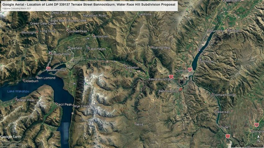
Figure 1 - View north along Upper & Lower twin water races of Water Race Hill F41/369 that supplied early working via
flumed pipe over Revell’s Gorge to Slaughteryard Hill Reservoir F41/399 to workings NE off Slaughteryard Hill. Kopuwai
                                                Consulting 28 03 2017

                                                                                                                     2
        Kopuwai Archaeology – Assessment Water Race Hill Subdivision – Bannockburn 2021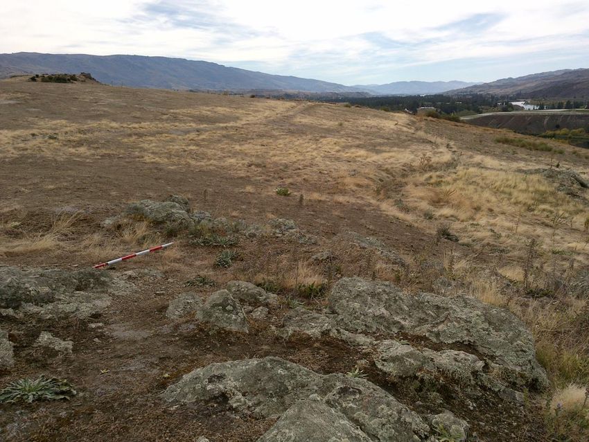
Contents
Abbreviations 5
Acknowledgements 6
Executive Summary 7
Introduction 10
Statutory Requirements 18
Methodology - Archaeological Survey 25
Physical Environment or Setting 27
Historical Background 29
Previous Archaeological Work 32
Research Results 34
Constraints and Limitations 38
Archaeological Assessment 40
HNZ site visit 44
Heritage Impact Assessment 45
Further Considerations 52
Recommendations 53
References 57
List of figures
Figure 1 - View north along Upper & Lower twin water races of Water Race Hill F41/369 that supplied early working
via flumed pipe over Revell’s Gorge to Slaughteryard Hill Reservoir F41/399 to workings NE off Slaughteryard
Hill. Kopuwai Consulting 28 03 2017 2
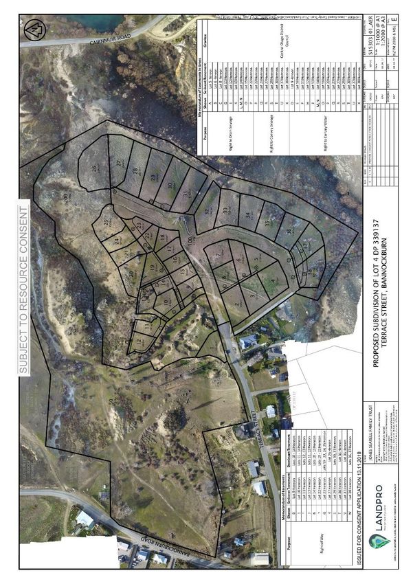
Figure 2 The Water Race Hill land Lot 4 DP339137 with key place names showing 11
Figure 3 Subdivision design REV E for Water Race Hill included in April 2019 subdivision application 12
Figure 4 Subdivision design REV I for Water Race Hill included in [May 2021] response to CODC Request for Further
Information 13
Figure 5 Map of NZAA wider view recorded sites on and around Terrace St – Lot 4 DP339137 Water Race Hill & Pt
Section 103 Slaughteryard Hill – March 2020 16
Figure 6 Google aerial –Lot 4 DP339137 Terrace Street Bannockburn; Water Race Hill Subdivision proposal with
recorded archaeological sites shown – Kopuwai Archaeology March 2021 17
Figure 7 Google aerial – Location of Lot 4 DP339137 Terrace Street Bannockburn; Water Race Hill Subdivision
proposal – Kopuwai Archaeology March 2021 17
3
Kopuwai Archaeology – Assessment Water Race Hill Subdivision – Bannockburn 2021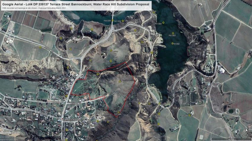
List of tables
Table 1 Summary of CODC operative plan 2008 Heritage objectives & polices ............................................................20
Table 2 of recorded archaeological sites associated with Lot 4 & Part Sec 103, with * sites specific to Water Race Hill
    Subdivision ..........................................................................................................................................................22
Table 3 of new unrecorded archaeological sites/features associated with Lot 4 & Part Sec 103 ..................................24
Table 4 of recorded archaeological sites specific to Water Race Hill extracted from Table 2 .......................................34
Table 5 of new unrecorded sites associated with Lot 4 & Part Sec 103 and * sites are specific to Water Race Hill
    Subdivision ..........................................................................................................................................................35

                                                                                                                                                                          4
            Kopuwai Archaeology – Assessment Water Race Hill Subdivision – Bannockburn 2021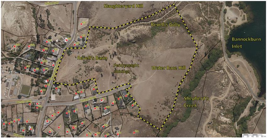
Abbreviations

Abbreviation         Definition
Arch Site            New Zealand Archaeological Association archaeological site recording data
                     base
CODC                 Central Otago District Council
DOC                  Department of Conservation
HNZPT                Heritage New Zealand Pouhere Taonga
LINZ                 Land Information New Zealand
NZAA                 New Zealand Archaeological Association
RMA                  Resource Management Act (1991)
RFI                  Request for information CODC
BHP                  The Bannockburn History Project – Paul Crump

                                                                                                 5
        Kopuwai Archaeology – Assessment Water Race Hill Subdivision – Bannockburn 2021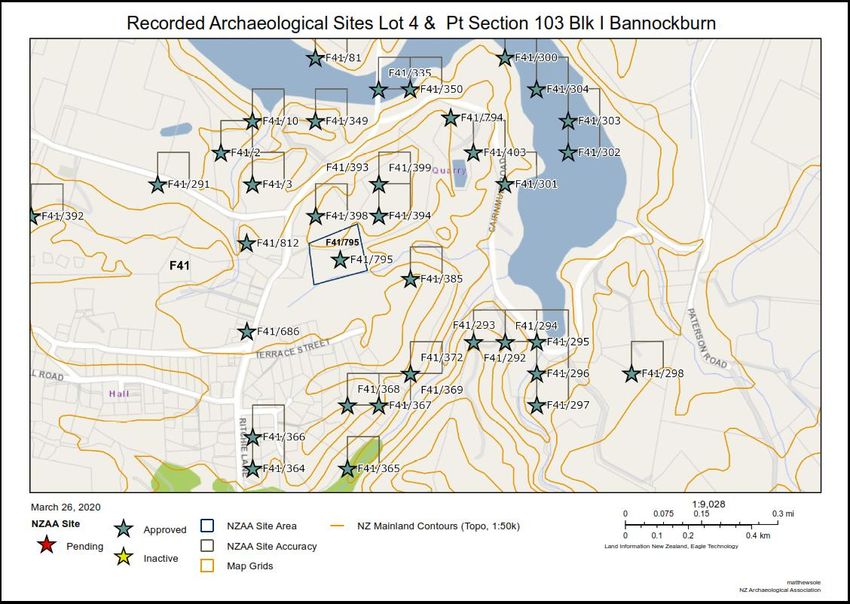
Acknowledgements
The DJ Jones and NR Searell Family Trusts for engaging with archaeological process right from the
beginning allowing the remaining archaeological values and features to be identified early and with good
concept design from Rough and Milne and subdivision build design from Landpro the project has
preserved the significant remaining heritage and the sites outstanding landscape and natural character
into a unique and sensitive subdivision. Underpinning Central Otago’s “World of Difference” values.
Doug Jones for engaging and assisting with access and site visits.
Landpro Walt Denley and Ritchie Ford for spatial data files and collaborative work with subdivision design
to preserve and minimise the damage and loss of heritage.
Adderley Head Chris Fowler and Meg Buddle for facilitating the resource consent stakeholder consultation
process.
6
Kopuwai Archaeology – Assessment Water Race Hill Subdivision – Bannockburn 2021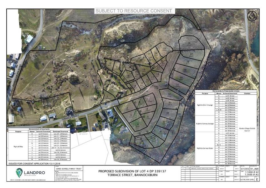
Executive Summary
In April 2019 the DJ Jones and NR Searell Family Trusts (“the Trusts” or “the applicant”) applied to the Central Otago
District Council (“CODC”) for subdivision and land use consents regarding 17.614 hectares (ha) near Bannockburn,
Central Otago (known as “Water Race Hill” or the “site”) to enable a proposed 38 lot subdivision and construction of
residential dwellings on each new lot, as well as a reserve lot, a balance lot and a roading lot (the “proposal”).

The site contains a significant and diverse array of recorded archaeological sites and features associated with early
1860’s goldmining, early main street stable site, commonage ground and coalmining through to the 1930’s involving
several water races, reservoirs, various sluicing’s off respective creek terraces and gullies.

In response to a Request for Further Information (“RFI”) issued by the CODC in May 2019, the applicant commissioned
Kopuwai Consulting to complete an expert assessment of historic heritage values associated with the site, the potential
adverse effects of the proposal on such values and to recommend amendments to the proposal in order to reduce the
level of effects resulting from the proposal.

This report addresses each of these matters. It has been prepared following an extensive process that included desk-
top research, several site visits, dialogue with the applicant and the applicant’s project team, and consultation with
Heritage New Zealand Pouhere Taonga.

As a consequence of this work several recommendations were made to amend the proposal to reduce its impact on
historic heritage values, all of which have been accepted by the applicant.

Historic Heritage Elements on the Subject Site

Water Race Hill and the adjoining Revell’s Gully, and interconnected, Slaughteryard Hill, contain a significant and
diverse array of recorded and un-recorded archaeological sites and features associated with early 1860’s goldmining
through to the 1930’s, as well as commonage grounds, farm steading, a historic main street stable site and hotel
orchards.

The historic heritage elements found on Water Race Hill, can be loosely grouped into the following categories:

  1.   Water races - main stem and minor distribution;

  2.   Sluice faces, sluice gulches, sludge channels and tailings;

  3.   Historic fences; and

  4.   Reservoir and stacked schist rock retaining features.

Note that of the above four groups of heritage elements, only the water races and the historic fences will be physically
affected by the subdivision proposal.

Summary of heritage impact assessment and recommendations

The combined heritage values of this peninsular bounded by Shepherd’s Creek, Bannockburn Inlet, Kawarau Arm and
Bannockburn Village features some of the earliest mining sequence remains of Bannockburn, a past historic main street
stable site, as well as later coalmining activity and farming steading.

The landscape, topography and heritage tapestry of the site is significant and combine to offer rich potential for its next
sequence of land stewardship. Our knowledge of previous uses of the site coupled with its location, landform and
setting requires due diligence for its future land use. The combined and collective early archaeological and landscape
evaluation and planning is a credit to all involved. The sensitive and respectful landscape master plan informed by the

                                                                                                                           7
         Kopuwai Archaeology – Assessment Water Race Hill Subdivision – Bannockburn 2021
spatial archaeological survey and good subdivision design recognises the significant values of the site and sets the basis
for the subdivision application for Water Race Hill.
The combined efforts of the design team have assessed and recognised the combined natural landscape, heritage
landscape, cultural setting and recreational attributes within and adjoining the subdivision proposal. Specifically for the
assessed archaeological features the subdivision has been fitted around and within historic sluiced gullies and gulches
constructively retaining the historic features and integrating them along with the landscape recreation values as a
subdivision with defining and enduring points of difference. Good design is preserving and integrating values and
features that on first appearances could have been deemed by some as hindrances.
Specific to Water Race Hill, the elements of twin water race components which serviced the gold workings and later
coal mines, the lower of twin branches, is proposed to be integrated into subdivision road reserve. Some less legible
portions of the upper twin branch water race remnants will be sacrificed for destruction, along with identified fence
sections, subject Heritage NZ approval via the pending archaeological authority application informed by this
archaeological assessment.
The lower water race along the bottom of the subdivision boundary along the true left of Shepherd’s Creek servicing
sluicing’s along the creek and around to Revell’s Gully is proposed for adaptive reuse as an informal bare ground
walking trail in the old race formation (F41/372) within Lot 200 the 3.59 ha public recreational reserve. It is proposed
for an archaeological authority to adaptively reuse the Shepherd’s Creek water race (F41/372) within Lot 200as an
informal walking trail within Lot 200. No modification would be required to the trail, other than some pegging/trail
marking, and some bramble vegetation clearance. The exact route that the trail will take is yet to be determined, in lieu
of an additional site visit to identify a logical and achievable route. This bare ground walking trail will form part of loop
around the Water Race Hill subdivision, and will enhancing engagement and appreciation of the heritage and landscape
values.
Along Shepherd’s Creek boundary and up and over the brow of the ridge overlooking Revell’s Gully are the remnant
remains of early hardwood (Totara) posts and wire fence subsequently repaired with ex railway sleeper posts and
rabbit netting. These are associated with earlier small farmlet and Bannockburn commonage grazing use. A
representative section of the fence line is proposed for retention along the bottom boundary of Shepherd’s Creek and
up above Revell’s Gully boarding lot 26 and some small remnants within Revell’s Basin boarding Lot 200.
Revell’s Gorge contains archaeological remnants of various phases of mining associated with the two lots and setting it
aside as public reserve with an appropriate management of historic and natural values will see these preserved and
appreciated into the future.
The proposed installation of a heritage interpretation panel detailing and interpreting what remains and how to care
for it will help empower community care and stewardship into the future along with informing recreational use.
Outside of the residential and roading components (excepting the adaptive reuse lower water branch) of the
subdivision but within Lot 200 there is a significant array of identified heritage remnants. As a local reserve these need
to be managed and preserved.
In summary the heritage landscape is assessed as being of medium value. The magnitude of impact arising from the
proposal is assessed as minor to moderate. Overall, taking into account the recommended changes, the proposal is
assessed as having slight to moderate impact on historic heritage values within the site.
Summary of archaeological assessment and recommendations
There are four recorded archaeological sites within Water Race Hill boundaries. However there are many other
archaeological features that have been identified through the site survey that have not been formally registered which
are identified in this report.
8
Kopuwai Archaeology – Assessment Water Race Hill Subdivision – Bannockburn 2021This report makes a number of recommendations centred around the guiding principle that every practical effort
should be made to avoid damage to any heritage or archaeological site, whether known, or discovered during any
redevelopment of the site. These are detailed below in the Recommendations section of the assessment report
9
Kopuwai Archaeology – Assessment Water Race Hill Subdivision – Bannockburn 2021Introduction
Purpose of report
This report provides an archaeological assessment and a heritage impact assessment of the proposed Water Race Hill
subdivision and land use consents regarding Lot 4 DP 339137. It encompasses heritage features associated with the site
and adjacent land parcels.
The report includes recommendations in relation to the resource consent applications and also recommends an
application for archaeological authority. It is to be read as a complete report and is applicable to the subdivision
scheme plan version REV I as prepared by Landpro supplied (the subdivision plan).
Description and scope of assessment commission
In 2016 I was approached to survey and identify remaining above ground archaeological sites and features of Stage one
of Water Race Hill off Terrace Road Bannockburn, with the purpose to inform subdivision design for a RMA resource
consent and inform an archaeological assessment to support an archaeological authority to Heritage NZ for consent to
destroy and or modify identified less significant remaining heritage that is unable to be avoided or needs modifying by
the subdivision design.
The scope has been primarily designed around Stage 1 Water Race Hill portion of Lot 4.The wider surrounds of the
Trust’s Lot 4 Revell’s Basin and Gully and Part Section 103 Slaughteryard Hill have been surveyed for heritage landscape
context and inform assessment of significance along with informing both the current subdivision plan and future
subdivision staging.
This was a forward thinking and best practice approach to be commended and acknowledged for front footing the
identification of remaining heritage values and being able to spatially identify and map early, the significant remaining
heritage values for sensitive and respectful incorporation into the subdivision design process early on. The use of a
landscape architect early on also facilitated with the identified heritage values the combining of the strategic and
integrated use of the sites topography and natural landscape and adjoining Bannockburn heritage town scape and the
recreational and amenity values of the Bannockburn Inlet and the wider Cromwell Basin.
Water Race Hill
The site is located near Bannockburn, Central Otago. It lies between Bannockburn Road and Shepherd’s Creek. It
contains 17.614 ha and is accessed off Terrace Street.
The combined land parcels and adjacent land feature remnants of progressive goldmining sequences from early ground
surface workings and with the sourcing and construction of water races and reservoirs along with the advances in
mining techniques saw the scale and extent of sluicing and hydraulic sluicing expand across the Bannockburn landscape
with Lot 4 and Part Sect 103 featuring intact and representative examples of such. A significant feature at the time
would have been the construction and operation of a likely canvas piped flume across Revell’s Gorge to the
Slaughteryard Hill Reservoir servicing the sluicing’s off Slaughter Hill to the east and around into the lower Revell’s
gorge.
The locality has also featured sites of store and stables associated with the early history and life of Bannockburn. A
defining feature coinciding and following on from the sustained period of gold mining is the rich and intense sequence
of coal mining companies that operated tightly within Slaughteryard Hill, Revell’s Gully, Shepherd’s and Bannockburn
Creeks. This phase saw occupation of the only remaining huts site change from gold miners to coal miners. The land
outside of the mining was used as Bannockburn commonage and farm steading evidenced by enduring early hardwood
post and wire fencing still remaining.
10
Kopuwai Archaeology – Assessment Water Race Hill Subdivision – Bannockburn 2021Figure 2 The Water Race Hill land Lot 4 DP339137 with key place names showing
The Proposal
Original proposal included in April 2019 Resource Consent Application
The applicant originally sought a resource consent from the CODC in April 2019 to subdivide one certificate of title (“the
Water Race Hill land”), totalling 17.614 hectares (ha) into:
38 residential allotments - Lots 1-38;
balance Lot - Lot 50 being 7.82 ha;
roading Lot - Lot 100 encompasses all the roading infrastructure and is 1.14 ha; and
proposed public reserve Lot - Lot 200 (3.59 ha) proposed to be vested with the CODC.
11
Kopuwai Archaeology – Assessment Water Race Hill Subdivision – Bannockburn 2021Figure 3 Subdivision design REV E for Water Race Hill included in April 2019 subdivision application
Amended proposal incorporating project team recommendations
Since the RFI letter of May 2019, the applicant has sought advice on the RFI and the key RMA issues from the project
team, namely:
a. the author;
b. landscape architects Tony Milne and Angie Nelson of Rough and Milne Landscape Architects;
c. planner Walt Denley of Landpro;
d. surveyor Richard Ford of Landpro; and
e. RMA lawyers Chris Fowler and Meg Buddle of Adderley Head.
The project team visited the site collectively on 18 March 2020. Several additional site visits have been completed by
individual members of the project team in order to better understand the environmental effects of the proposal and to
develop robust responses to them. In addition, members of the project team have collaborated to ensure that
recommendations are feasible and accurately recorded in amended subdivision design plans.
Based on the project team’s recommendations, the applicant has decided to make the following changes to the
proposal:
a. the number of residential lots included in the proposal has been decreased from 38 to 35 (by removal of
original Lots 26, 27 and 32);
b. a portion of original Lot 25, and the entirety of original Lot 26, is now located within Lot 200; and
c. the size of original Lots 27-35 has been increased; and
d. several additions to the proposal in recognition of the archaeological features, as a result of the
recommendations made in this report. The specific additions will be discussed in more detail below.
12
Kopuwai Archaeology – Assessment Water Race Hill Subdivision – Bannockburn 2021Figure 4 Subdivision design REV I for Water Race Hill included in [May 2021] response to CODC Request for Further Information
The subdivision plan (version REV I) shown in Figure 4 is the version that is the basis of this archaeological and heritage
impact assessment.
Legal description/appellation of land affected
The legal description of the land affected is Lot 4 DP 339137 (referred to throughout as the “Water Race Hill land”).
Work (and date) of assessment undertaken and by whom
To complete this assessment I have (Kopuwai Consulting) undertaken the following work:
Three archaeological surveys involving an
o Initial survey of a portion of Lot 4 proposed for a 9 lot subdivision Landpro RC S15303 dated 3 10 2016
over what is named ‘Water race hill’ on 7 July 2016, which identified the remnant remains of NZAA
recorded sites and an array of unrecorded features relating to goldmining; coalmining; farm steading.
o A wider heritage landscape survey beyond the Stage 1 Water Race Hill subdivision proposal involving
the remainder of Lot 4 and all of Part Sect 103 owned by Jones Searell Family Trust was undertaken in
28 March 2017 which located the remnant remains of the recorded sites of water races; reservoir and
Chinese dwelling and garden site. A significant discovery from remnants water race abutments either
side of Revell’s Gully was the operation of a likely canvas piped flume that would been the
constructed solution to conveying water between Water Race Hill and Slaughteryard Hill across
Revell’s Gorge to the Slaughteryard Hill Reservoir servicing the sluicing’s off Slaughter Hill to the east
and around into the lower Revell’s gorge.
13
Kopuwai Archaeology – Assessment Water Race Hill Subdivision – Bannockburn 2021o A follow up archaeological survey for an assessment of effects of the subdivision plan Rev E on the
remaining above ground archaeological sites and values on 31 August 2018. This revealed hand
stacked tailings, schist boxed sluicing’s; rock blasted sludge channel with stacked rock walling from
the blasted waste; artefact scatters from early occupation; sluice gulches; and coalmining features
and artefacts along with sites from early Bannockburn establishment.
A few project planning and stakeholder onsite visits were undertaken as well as part of the design and
planning stages as various iterations of the subdivision proposal evolved.
In Jan 2021 Heritage NZ Area Manager Jane McKnight and Otago Southland Archaeologist Nikole Wills
accompanied by Kopuwai Consulting Archaeologist and Trustee Doug Jones were given a site visit over the
Water Race Hill Rev H and the adjacent Jones Searell parcel known as Slaughteryard Hill where the setting and
context for the Rev H subdivision could be viewed in relation to the Bannockburn main street, its remaining
heritage buildings, the wider settlement and Revell’s Sluiced basin and Gully down to the Bannockburn Inlet
and its amenity values.
The Archaeological Assessment has determined an Archaeological Authority Application is required as while
the new subdivision Rev I, aligned roading, water, waste and stormwater services, residence and associated
services installation will, with marking archaeological features and sensitive earthworks and construction,
preserve the majority of the above ground features, some water race and historic fence line components and
other minor gold mining elements will be adaptively repurposed, and or disturbed, and destroyed, triggering
the requirement of an archaeological authority application.
While the priority for the archaeological authority has been pre 1900’s there has been an RMA historic
heritage assessment effects on post-1900 historic heritage for the land parcels. In more recent years Doug
Jones has grazed the Water Race Hill land and reutilised the water races for wild flood irrigation. Between
Water Race Hill and Bannockburn Road south west of the subdivision, 1980’s development has led to:
o the loss of recorded sites F41/366 Patterson & Co Dam – Ridlands 1890 map;
o modification & loss of 45% of Pennyweights sluicing’s F41/368;
o Loss of a section of water from Patterson & Co Dam servicing the sluicing’s in Pennyweights Sluicing’s
F41/368; Revell’s Basin and Gully F41/385 & F41/795 and the workings off Slaughteryard Hill and later
Colleries F41/403 & F41/301.
o Damage to sluice faces on the south side of Revell’s Basin F41/385 & F41/795 and burial sluice
channels and tailings within the Revell’s sluicing’s from road cut spoil stock piling from the
redeveloped access into Bannockburn required as part of the Lake Dunstan impoundment.
o CODC stormwater and waste infrastructure installed down through Pennyweights Sluicing has likely
destroyed schist lined boxed sluice channels and has damaged and destroyed hand stacked tailings,
fencing and sludge channel draining the Revell’s Basin sluicing’s. Recent upgrades caused further
impacts on these recorded archaeological features and sites.
Brief background section to include any information relevant to this assessment. e.g. any
issues/occurrences which lead to this assessment being commissioned; previous reports relating to
this assessment and area affected
The area was surveyed in Feb 1982 by Neville Ritchie archaeologist for the Clutha Valley Hydro Development project
recording on New Zealand Archaeological Site recording database 8 recorded archaeological sites across Lot 4
Deposited Plan 339137 and Pt Sec 103. These were referenced in the 2016 – 2017 archaeological surveys associated
with the Trusts Bannockburn parcels. The recorded historical sites were:
o F41-368 S133-808 Lower Remains Pennyweight Gully Sluicing’s
14
Kopuwai Archaeology – Assessment Water Race Hill Subdivision – Bannockburn 2021o F41-369 S133-809 Upper Water race from F41/366 Patterson & Co Dam to a branch servicing F41-368
Pennyweights Sluicing’s and a branch to the Lower Water Race Hill race servicing small sluicing’s of
water race hill and beyond to a sluice gulch down in Revell’s Gorge. The Upper Water Race Hill race
continues to F41-385Revell’s Gully and via a past flumed pipe over Revell’s Gorge to F41-399
Slaughteryard Hill Reservoir via F41-398 Slaughteryard Hill reservoir race to F41-403 NE Slaughteryard
Hill Sluicing area and coal pits – now modified extensively by gravel quarry & sewage pond and via a
shallow branch water race supplying F41-394 Chinese occupation site.
o F41-372 S133-812 water race TL above Shepherd’s Creek below Lot 4 Water Race Hill eastern
boundary - servicing workings in Revell’s Gully & Shepherd’s Creek & later Collieries
o F41-385 S133-825 Revell’s Basin workings, Sludge Channels, dams, tailings, and dual water races on
north side of the basin below Slaughteryard Hill
o F41-394 S133-835 Slaughteryard Hill Chinese Hut and occupation site & artefacts
o F41-398 S133-839 Slaughteryard Hill reservoir race to F41-399 Slaughteryard Hill Reservoir serviced by
canvas fluming from F41-366 Patterson & Co reservoir
o F41-399 S133-840 Reservoir Slaughteryard Hill
o New site records for farmstead/commonage fencing ex Section 40 SO_3081 June 1915 _Sect 40
(Water Race Hill) surveyed for Ellen Taylor married to Jack Taylor miner, carter & mail Contractor
1878 - 1937 .
o New site records for various colliery sites off Revell’s Gully and Slaughteryard Hill & Shepherd’s Creek
as recorded on Bannockburn History project Map Sheet 6 #s 185, 189, 502, 186, 187– Paul Crump &
various early mining plans SO3929 Coal Lease Sect 80 John Hodson 1910, SO3939 Coal Lease Sect 85 E
J McCabe & G Crabbe 1912, SO3940 Coal Lease Sect 86 & 38 J Gordon H Russel R Robertson Ellen M
Gibson 1912, SO3941 Coal Lease Sect 87 Ellen Mary Gibson 1912.
o New site record for Slaughteryard Hill lower twin races likely extensions off F41/812 to include lineal
reservoirs servicing sluice workings and later collieries down into Bannockburn Inlet ex Revell’s Gully
Shepherd’s Creek Bannockburn Creek.
o Site record update for F41/369 to include the lower water race (proposed for adaptive reuse an active
path) on Water Race Hill as a branch of the upper water from Patterson & Co reservoir F41/366
15
Kopuwai Archaeology – Assessment Water Race Hill Subdivision – Bannockburn 2021Figure 5 Map of NZAA wider view recorded sites on and around Terrace St – Lot 4 DP339137 Water Race Hill & Pt Section 103
Slaughteryard Hill – March 2020
16
Kopuwai Archaeology – Assessment Water Race Hill Subdivision – Bannockburn 2021Figure 6 Google aerial –Lot 4 DP339137 Terrace Street Bannockburn; Water Race Hill Subdivision proposal with recorded
archaeological sites shown – Kopuwai Archaeology March 2021
Figure 7 Google aerial – Location of Lot 4 DP339137 Terrace Street Bannockburn; Water Race Hill Subdivision proposal –
Kopuwai Archaeology March 2021
17
Kopuwai Archaeology – Assessment Water Race Hill Subdivision – Bannockburn 2021Statutory Requirements
There are two main pieces of legislation in New Zealand that control work affecting archaeological sites. These
are the Heritage New Zealand Pouhere Taonga Act 2014 (HNZPTA) and the Resource Management Act 1991
(RMA). This report provides an assessment of the proposal against both enactments.
Heritage New Zealand Pouhere Taonga Act 2014
Heritage New Zealand administers the HNZPTA. It contains a consent (authority) process for any work
affecting archaeological sites, where an archaeological site is defined as:
Any place in New Zealand, including any building or structure (or part of a building or structure), that -
a. Was associated with human activity that occurred before 1900 or is the site of the wreck of any
vessel where the wreck occurred before 1900; and
b. Provides or may provide, through investigation by archaeological methods, evidence relating to
the history of New Zealand; and
c. Includes a site for which a declaration is made under section 43(1)
Any person who intends carrying out work that may modify or destroy an archaeological site, must first
obtain an authority from Heritage New Zealand. The process applies to sites on land of all tenure
including public, private and designated land. The HNZPTA contains penalties for unauthorised site
damage or destruction.
The archaeological authority process applies to all archaeological sites, regardless of whether:
The site is recorded in the NZ Archaeological Association Site Recording Scheme or included in the
Heritage New Zealand List,
The site only becomes known about as a result of ground disturbance, and/ or
The activity is permitted under a district or regional plan, or a resource or building consent has
been granted
Heritage New Zealand also maintains the New Zealand Heritage List/ Rarangi Korero of Historic Places,
Historic Areas, Wahi Tupuna, Wahi Tapu and Wahi Tapu Areas. The List can include archaeological sites.
Its purpose is to inform members of the public about such places.
Archaeological sites are protected under Section 42 of the HNZPTA, and it is an offence to carry out work
that may "modify or destroy, or cause to be modified or destroyed, the whole or any part of that site if
that person knows, or ought reasonably to have suspected, that the site is an archaeological site",
whether or not the site has been previously recorded. Each individual who knowingly damages or
destroys an archaeological site without having the appropriate authority is liable, on conviction, to
substantial fines (Section 87).
Any person wishing to carry out work on an archaeological site that may modify or destroy any part of the
site, including scientific investigations, must first obtain an authority from Heritage New Zealand (Sections
18
Kopuwai Archaeology – Assessment Water Race Hill Subdivision – Bannockburn 202144(a),(c)). The HNZPTA stipulates that an application must be sought even if the effects on the
archaeological site will be no more than minor as per Section 44(b). A significant change from the Historic
Places Act (1993) is that "an authority is not required to permit work on a building that is an
archaeological site unless the work will result in the demolition of the whole of the building" (Section
42(3)).
Heritage New Zealand will process the authority application within five working days of its receipt to
assess if the application is adequate or if further information is required (Section 47(1)(b)). If the
application meets the requirements under Section 47(1)(b), it will be accepted and notice of the
determination will be provided within 20 to 40 working days. Most applications will be determined within
20 working days, but additional time may be required in certain circumstances. If Heritage New Zealand
requires its own assessment of the Maori values for the site, the determination will be made within 30
working days. If the application relates to a particularly complex site, the act permits up to 40 days for the
determination to be made. Heritage New Zealand will notify the applicant and other affected parties
(e.g., the land owner, local authorities, iwi, museums, etc.) of the outcome of the application.
Once an authority has been granted, modification of an archaeological site is only allowed following the
expiration of the appeals period or after the Environment Court determines any appeals. Any directly
affected party has the right to appeal the decision within 15 working days of receiving notice of the
determination. Heritage New Zealand may impose conditions on the authority that must be adhered to
by the authority holder (Section 52). Provision exists for a review of the conditions (see Section 53). The
authority remains current for a period of up to 35 years, as specified in the authority. If no period is
specified in the authority, it remains current for a period of five years from the commencement date.
The authority is tied to the land for which it applies, regardless of changes in the ownership of the land.
Before any changes of ownership, the land owner must give notice to Heritage New Zealand and advise
the succeeding land owner of the authority, its conditions, and terms of consent.
An additional role of Heritage New Zealand is maintaining the New Zealand Heritage list, which is a
continuation of the Register of Historic Places, Historic Areas, and Wahi Tapu Areas. The list can
include archaeological sites. The purpose of the list is to inform members of the public about such places
and to assist with their protection under the RMA (1991).
19
Kopuwai Archaeology – Assessment Water Race Hill Subdivision – Bannockburn 2021Resource Management Act 1991
The RMA requires City, District and Regional Councils to manage the use, development, and protection
of natural and physical resources in a way that provides for the wellbeing of today’s communities while
safeguarding the options of future generations. The protection of historic heritage from inappropriate
subdivision, use, and development is identified as a matter of national importance (section 6f).
Historic heritage is defined as those natural and physical resources that contribute to an understanding
and appreciation of New Zealand's history and cultures, derived from archaeological, architectural,
cultural, historic, scientific, or technological qualities.
Historic heritage includes:
historic sites, structures, places, and areas
archaeological sites;
sites of significance to Maori, including wahi tapu;
surroundings associated with the natural and physical resources (RMA section 2).
These categories are not mutually exclusive and some archaeological sites may include above ground
structures or may also be places that are of significance to Maori.
Where resource consent is required for any activity the assessment of effects is required to address
cultural and historic heritage matters (RMA 4th Schedule and the district plan assessment criteria).
RMA historic heritage is defined as those natural and physical resources that contribute to an understanding
and appreciation of New Zealand's history and cultures, derived from archaeological, architectural, cultural,
historic, scientific, or technological qualities.
Historic heritage includes:
• historic sites, structures, places, and areas
• archaeological sites;
• sites of significance to Maori, including wahi tapu;
• surroundings associated with the natural and physical resources (RMA section 2).
These categories are not mutually exclusive and some archaeological sites may include above ground
structures or may also be places that are of significance to Maori.
Where resource consent is required for any activity the assessment of effects is required to address cultural
and historic heritage matters (RMA 4th Schedule and the district plan assessment criteria).
The Resource Management Act 1991 requires local authorities to develop and operate under a district plan.
District Plan provisions relevant to historic heritage
Table 1 Summary of CODC operative plan 2008 Heritage objectives & polices
CODP Chapter Objective/Policy
14.3.4 Objective – Archaeological Sites
To recognise and provide appropriate protection for the values associated with the District’s
20
Kopuwai Archaeology – Assessment Water Race Hill Subdivision – Bannockburn 2021archaeological sites.
Heritage Buildings,
Places, Sites, Objects
and Trees Chapter 14.4.6 Policy – Archaeological Sites
To provide for the conservation of values associated with the District’s archaeological sites by:
(a) Identifying such registered sites, on the planning maps.
(b) Ensuring that works carried out within or near such sites recognise and provide for their
values where appropriate.
(c) Requiring an assessment of the values associated with any such sites as part of any
subdivision or land use consent in circumstances where a significant adverse effect may result,
and requiring protection where such values are considered to be significant.
16.3.6 - Objective - Heritage Values
To ensure that subdivision does not facilitate development that may adversely affect heritage
and cultural values including cultural values of importance to Kai Tahu ki Otago.
Subdivision Chapter
16.4.7 - Policy - Subdivision Design
To require that the design of subdivision, where relevant to the intended use, provides for the
following matters:
(h) Facilitates retention of the heritage values of a site or area.
The Operative CODC District Plan (the District Plan) recognises that the district has a wealth of heritage
items and precincts that are an important part of the area’s amenity and character. Activities that affect
properties within heritage precincts or heritage items are evaluated against the rules outlined in Section
11, heritage precincts, and Section 14, heritage buildings, places, sites, objects and trees.
The District Plan register includes heritage buildings, places, sites, objects and trees that are recognised as
being significant to the heritage of the district, and their inclusion on Schedule 19.4 affords them
protection while encouraging their continued use, adaptive reuse, and development. The rules relating to
these heritage items are outlined in Section 14 of the District Plan. The register includes all Heritage New
Zealand Category 1 and Category 2 listed sites, which have been evaluated according to criteria outlined
in the HNZPTA. Listed items in the District Plan are discussed below in section containing the Heritage
Impact Assessment.
Outlined below are the heritage features and values across the Trust’s parcels Lot 4 DP339137 and Part
Sec 103 and neighbouring land where heritage features on the Trust’s land are related and connected as
heritage systems. This assessment of surveyed heritage pre and post 1900 assesses the impacts of the
Water race hill subdivision on the remaining heritage features and values and provides an assessment of
effects with recommendations to inform the Resource Consent and archaeological authority.
Some of the historic elements on the site include:
• Water races;
21
Kopuwai Archaeology – Assessment Water Race Hill Subdivision – Bannockburn 2021• Sluice faces; Sluice gulches
• Sludge Channels;
• Tailings – stacked & revetted and
• Old hardwood post and wire fence lines.
• Coal pits prospects & underground measures
• Old flume site – Revell’s Gully
• Dams/reservoirs
• Locations of past historic store & stables
• Ex public reserve and Bannockburn Commonage
• Artefact scatters
The features are of mining, farm steading and Bannockburn commonage and early town service origins.
Past early survey plans record sites of past recreation reserve 1924 (SO35) Ex Stables SO3935 1908.
Archaeological Association recorded sites on Arc Site
The heritage associated and connected with Lot 4 Water Race Hill & Part Sect 103 land includes 16 NZ
Archaeological Association recorded sites. Asterisked sites 4* are directly related to Water Race Hill Rev I
subdivision and are all pre 1900 sites as defined by the HNZ Act.
These are sites associated with human activity that occurred before 1900 and provides or may provide,
through investigation by archaeological methods, evidence relating to the history of New Zealand.
Table 2 of recorded archaeological sites associated with Lot 4 & Part Sec 103, with * sites specific to Water Race Hill
Subdivision
NZAA_ID IMPERIAL NAME ShortDescr SiteType SiteFeatur
1 F41/403 S133/844 NE Sluicing area/coal Mining - gold Sluicing’s/
Slaughteryard pits coal pits
Hill
2 F41/366 S133/806 Patterson & Co Dam Industrial Dam
Reservoir
3 F41/369* S133/809 Upper Water Water races Industrial Water race
Race Hill Race
– with a branch
race to
Pennyweights
sluicing’s, the
upper branch
race Revell's
Gully &
Slaughteryard
Hill and branch
to Lower
Water Race Hill
to Revell’s
Gorge
sluicing’s
4 F41/372* S133/812 Shepherd’s Ck Water race Industrial Water race
TL above Gorge
Lot 4
5 F41/301 S133/691 Slucings/sluice Sluiced area/coal Mining - gold Sluicing’s/
faces Ex TL drives & coal sluicing face
Bannockburn
22
Kopuwai Archaeology – Assessment Water Race Hill Subdivision – Bannockburn 2021Ck
6 F41/367 S133/807 Shepherd’s Ck Water race Industrial Water race
TR high
7 F41/292 S133/667 Shepherd’s Ck Water race/dam Industrial water
low wr & dam race/dam
8 F41/393 S133/834 NW Water race Industrial Water race
Slaughteryard
hill
9 F41/399 S133/840 Slaughteryard Mining dam Industrial Dam
Hill Reservoir
10 F41/794 Slaughteryard Remnants of Industrial Chimney
Hill Antimony schist-lined
Smelter chimney flue &
Chimney Flue smelter of the
Carrick Range
Antimony
Company
constructed in the
1880s.
11 F41/385* S133/825 Revell's Basin Ground Mining - gold Sluicing’s/
Sluicing’s & sluicing/water sluicing
water races races face/water
races
12 F41/795* Revell's Gorge Revell's gorge is a Mining - gold Tailings,
broad sludge Water race -
channel with tail race,
several features Mining
such as short tail workings,
races, old Sluicing’s/
sluicing’s, and sluicing face
piles of tailings,
with sluice faces
on the N side.
Water races on
Slaughteryard Hill
lead to these
faces.
13 F41/368* S133/808 Pennyweights Sluice gully Mining - gold Sluicing’s/
Sluice Gully sluicing face
14 F41/394 S133/835 Slaughteryard Hut site Historic - Hut floor/
Hill hut & domestic site/water
occupation site race
15 F41/365 S133/805 Shepherd’s Ck Tailings/drive Mining - gold Tailings/drive
TL Tailings
16 F41/398 S133/839 Slaughteryard Water race Industrial Water race
reservoir race
The various effects of the Lot 4 Water Race Hill REV I subdivision proposal on the recorded and unrecorded
lower twin race and early fencing are described and assessed within this assessment.
Unrecorded archaeological sites/features
New sites records are pending for:
New site records for (Water Race Hill) farmstead/commonage fencing ex Section 40 SO_3081
June 1915 _Sect 40 (Water Race Hill) surveyed for Ellen Taylor married to Jack Taylor miner,
carter & mail Contractor 1878 – 1937 source BHP.
23
Kopuwai Archaeology – Assessment Water Race Hill Subdivision – Bannockburn 2021 New site records for various colliery sites off Revell’s Gully and Slaughteryard Hill & Shepherd’s
Creek as recorded on Bannockburn History project Map Sheet 6 #s 185, 189, 502, 186, 187– Paul
Crump & various early mining plans SO3929 Coal Lease Sect 80 John Hodson 1910, SO3939 Coal
Lease Sect 85 E J McCabe & G Crabbe 1912, SO3940 Coal Lease Sect 86 & 38 J Gordon H Russel R
Robertson Ellen M Gibson 1912, SO3941 Coal Lease Sect 87 Ellen Mary Gibson 1912.
New site record for Slaughteryard Hill lower twin races likely extensions off F41/812 to include
lineal reservoirs servicing sluice workings and later collieries down into Bannockburn Inlet ex
Revell’s Gully Shepherd’s Creek Bannockburn Creek.
Site record update for F41/369 to include the linked lower water race (proposed for adaptive
reuse an active path) on Water Race Hill as a branch of the upper water from Patterson & Co
reservoir F41/366
Table 3 of new unrecorded archaeological sites/features associated with Lot 4 & Part Sec 103
New Unrecorded Sites
Location Name ShortDescr Site Type Site Feature
Water race Hill* Historic fence Hard wood post & agriculture Fence posts &
wire wire
Various Collieries Coal mine – Mining Tunnel,
tunnels & Shafts,
processing Processing
site remains
Slaughteryard Twin water Water races & Mining Water races –
Hill races & lineal lineal reservoir enlarged
reservoir water races
The collieries/coalmining sites are largely post 1900 and are managed under the RMA Act heritage provisions
administered by CODC.
Being recorded on the Arch Site will provide an alert to CODC planning and any activity potentially affecting
these sites and should trigger an assessment of effects to address cultural and historic heritage matters.
Referenced in the Appendix 1 for Local Authority best practise in the management of post 1900 RMA Heritage
is the Parliamentary Commissioner for the Environment Te Kaitiaki Taiao a Te Whare Paremata -Historic and
Cultural Heritage Management Local Authority Good Practice Guide.
The Lot 4 Water Race Hill REV I subdivision proposal, while adjacent to Revell’s Gully and Shepherd’s Creek coal
lease sites and potentially above some of the coal mine dives, has no direct physical effect or connection to
them apart from the Shepherd’s Creek water race along the bottom boundary F41/372 that is likely to have
serviced the various Collieries in and around Revell’s Gully and Shepherd’s Creek. There are records of
ventilation shafts off Slaughteryard Hill. In relation Water Race Hill no above ground surface of evidence of
ventilation shafts was observed.
24
Kopuwai Archaeology – Assessment Water Race Hill Subdivision – Bannockburn 2021Methodology - Archaeological Survey
The Archaeological Survey of Water Race Hill was carried out using both desk-top research methods and an on-
site survey of the proposed parcels for subdivision and its immediate environs and features. The desk-top
assessment involves consulting a wide range of archival sources to try to illuminate the historical development
and chronology of the history and its associated heritage values. The assessment used the following sources to
identify the origins and use of the water race:
19th century surveyors maps;
Land titles and land transfer surveys (LINZ);
Aerial photographs 1949 SN533_F_39_31304 & 1974 SN3778_C_ 13 (retrolens) LINZ aerial
CC12_0310 2014 - (LINZ);
Photographic and documentary archives (on-line archive repositories - Archives NZ, Digital NZ,
National Library of NZ, Papers Past; Ron Murray Historic Image Library Collection
Local Bannockburn/Central Otago histories and similar publications;
o Bannockburn Heritage Landscape Study by Janet Stephenson, Heather Bauchop & Peter
Petchey;
o Heart of the Desert by James Crombie Parcell;
o The Bannockburn History Project by Paul Crump;
NZAA ArchSite;
Archaeological Assessment Reports;
o Archaeological assessment for Lake Dunstan Trail – Clyde to Cromwell via Bannockburn on
south side Lake Dunstan for Central Otago Queenstown Trail Network Trust 2018 by Matthew
Sole Kopuwai Consulting 2018; and
o Heritage Assessment Bannockburn Sluicing’s Historic Reserve by Peter Petchey Southern
Archaeology Ltd 2016.
o
Three archaeological field surveys and three follow up site visits have been undertaken between 2016 and
2021.
The use of spatial data (shapefiles from Landpro of various subdivision design revisions along with Rough &
Milne Landscape design) & GPS survey waypoints and tracks; NZAA site records; landform data; archaeological
features have been spatially mapped in Manifold 8 Geographic Information system.
This has allowed the Water Race Subdivision designs with geographic and existing and destroyed modified
archaeological features to be displayed and mapped for sharing across the project parties and clients.
The early mapping and sharing of spatial data have been key to informing the design needs for the subdivision
and the sensitive and informed subdivision design around the remaining historic features.
Plans, spatial data and spreadsheet tables were prepared identifying the subdivision parcels and requiring
protection measures for archaeological features within the respective parcels along with parcels with
archaeological features requiring an archaeological authority to modify and or destroy.
This has worked with reciprocity in subdivision design and archaeological assessment and heritage preservation
and management.
The spatial database has georeferenced current and early 1949 & 1974 aerials which allow visual assessment of
the project land use and it’s the wider heritage landscape change over time and visual reference to
archaeological site and features and their change and condition over time .
It facilitates a wider landscape approach to heritage preservation and management informing future land use
and sensitive lying down of new cultural layers. By way of informed sensitive design to preserve identified
significant heritage and adaptive reuse of suitable elements within informed consent for modification and or
recorded destruction where deemed appropriate or unavoidable.
25
Kopuwai Archaeology – Assessment Water Race Hill Subdivision – Bannockburn 2021Following several subdivision design revisions through project party collaboration, with stakeholders in general
agreement, Heritage NZ (HNZ) Otago Southland Area Manger Jane McKnight and regional HNZ archaeologist
Nikole Wills were hosted on a guided site visit. This was with project archaeologist Matt Sole and trustee Doug
Jones on the 20 Jan 2021 to gain an understanding of the refined subdivision proposal and a feel for the
remaining heritage and landscape values and setting of the site and within Bannockburn and the wider
Cromwell basin.
26
Kopuwai Archaeology – Assessment Water Race Hill Subdivision – Bannockburn 2021Physical Environment or Setting
Description of natural landscape and the context of the affected area within it. e.g. geology,
topography, climate, vegetation, streetscape, curtilage, aspect and prevailing wind
The area lies within a distinctive landscape featuring the Cairnmuirs to the east, the Old Woman Range to the
south and the Carrick Range and Mt Difficulty to the west with the Pisa Range to the north basically encircling
the site and Bannockburn.
The southern portion of Lot 4 sits on a gentle spur with Shepherd’s Creek on the southeast side and Revell’s
Gorge and Revell’s Basin incorporated and forming the northern boundary and with part sect 103 which is a
peninsular featuring Slaughteryard Hill bounded by Bannockburn Inlet to the east previously Bannockburn
Creek before inundation and likewise the Kawarau Arm to the north previously the Kawarau River and rapids.
Bannockburn Road and Town form the west boundary for both.
The underlying strata is schist formed from mudstone and sandstone by heat and tectonic forces during the
Jurassic period. Off the eastern flanks of Slaughteryard hill are some significant fossil deposits, aligned to the
origin of Bannockburns coal and shale that had there gestation with the large freshwater complex (called Lake
Manuherikia) with its margins being peat rich swaps which created the coal and shale deposits.
The vegetation is a mix of indigenous and introduced woody shrub land in the gullies of Shepherd’s and
Revell’s. The open undulating areas feature a lower stature sward mix of dryland indigenous and introduced
species.
The climate is semi arid, created by a rain shadow of the Southern Alps and the high Ranges of the Old Man
and Old Woman which results in hot dry summer and very cold harsh winters creating an environment which is
tough on plants and humans. With high sunshine hours giving rise to high evapotranspiration the soils are
predominately in moisture deficit.
Beyond the Water Race Hill subdivision, Lot 4 has the original town as its western streetscape providing clear
connection to its past as a small rural community. The new subdivision is an extension of Terrace St, a small
feeder road into Bannockburn.
Description of changes to/patterns of land use which may have affected cultural occupation
Adopted from Bannockburn Heritage Landscape Study Stephenson et al.
Tangata whenua for the area include people associated with Te Runanga o Otakou, Kati Huirapa Runaka ki
te Puketeraki, and Te Runaka o Moeraki. Of Kai Tahu, Kati Mamoe, Waitaha, and Rabuva’i descent, the iwi
still retain strong connections to the land, and this is borne out by names and stories of the area. Physical
traces (archaeological sites) in the study area and in the vicinity also tell of occupation of the area by Maori as
far back as the moa-hunter period.
Central Otago not only provided access to the pounamu sources further west, but was also a seasonal
source of resources such as moa, water fowl, and eels. Silcrete and porcellanite were quarried from Central
Otago outcrops for making tools. One of the best known moa hunter sites is in the Hawksburn Valley just east
of the study area.
27
Kopuwai Archaeology – Assessment Water Race Hill Subdivision – Bannockburn 2021The Bannockburn area was settled by Europeans from the establishment of Kawarau Station in 1858. An
interesting characteristic of the area is that families tend to ‘stick around’—there are some families who have
been established in the area for many generations and whose descendants still live in the community,
and others with family links who have returned. The past twenty years have seen an influx of new people
into the area, particularly since the early 1990s. The community therefore reflects a range of ‘knowing’
of the landscape and its history, from those who draw from long family or personal engagement, to those
who have a particular interest in the area’s heritage and Bannockburn have made a point of researching
and collecting information, and to those who have spent a shorter time in the area (but are frequently
no less passionate about it).
As well as being a place where people live, work, and commute from, Bannockburn is increasingly
becoming a place where people visit. The presence of heritage features, and in particular the DOC
reserves, draws tourists. People also come to explore the settlement, enjoy the Bannockburn Inlet, camp
at one of the two camping grounds (the Domain and the Cairnmuir camping grounds), and visit the growing
number of wineries. Organised events such as the Bannockburn Gutbuster and the Carricktown Crusher
(mountain-bike races) have also drawn many people to the area in recent years.
Mention whether the nature of the vegetation or topography may have affected the survey,
and explain why. Also explain what impact this may have on the assessment
Seasonal spring rainfall and subsequent vegetation growth and cover had significant effects on the visibility and
legibility of remnant archaeological features especially with water race components and small sequences of
sluice channels and small tailing sequences of the study area.
As this project has covered several year’s seasonal vegetation variation has been contrasting with the earlier
site visits in 2016 and 2017 having significantly less vegetation cover with a correspondingly much higher
remnant archaeological survey discovery and interpretative value. In more recent visits, the archaeological
feature legibility has been compromised by higher and denser vegetation cover.
Within the area that will become Lot 200, the combination of natural steep gully face topography and man-
made steep sheer sluice faces compounded by high thick brier and woody weed cover restricted and
complicated survey completeness,. There is likely undetected and therefore unrecorded archaeological
features within Lot 200. The survey is confined to above ground archaeological features and sites with no
below surface investigative test pitting.
While outside of the Water Race Hill subdivision the recorded Chinese occupation site and the schist retained
bench with the Revell’s Sluice basin hold clear evidence and potential for investigative archaeological
excavation and research.
28
Kopuwai Archaeology – Assessment Water Race Hill Subdivision – Bannockburn 2021You can also read