University of Kent Canterbury - SUPPLEMENTARY PLANNING GUIDANCE - Innovation Park
←
→
Page content transcription
If your browser does not render page correctly, please read the page content below
University
  of Kent
Canterbury
Innovation Park

SUPPLEMENTARY PLANNING GUIDANCE
                          CANTERBURY
                          DISTRICT
                          LOCAL PLAN

                           September
                              2004
Contents Chapter One: Introduction Chapter Five: Development
Requirements
Background
Purpose and format of the brief and procedure Building brief (SEEDA and UK requirements)
Guiding objectives Phasing / programme
Integration with existing uses
Chapter Two: Site Context and
Description Chapter Six: Development Strategy
and Design Principles
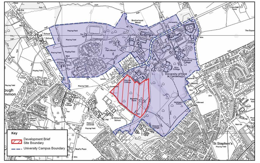
Site Context
Site Description Siting, landmarks and views
- Location and size Access and car parking
- Adjacent land uses Setting for the listed building-Beverley Farmhouse
- Topography Sense of place /character
- Access and gateways Scale and massing
- Agriculture and land management Building flexibility and adaptability
- Heritage and archaeology Environment and sustainability
- Nature conservation Materials and architectural context
- Ground conditions Security and public access
- Distribution of existing vegetation Landscape design
- Views Surface Water Drainage
- Contextual analysis - relationship Foul Drainage
with the campus
Planning history Chapter Seven: Planning Strategy
The planning application
Chapter Three: Site Constraints and Supplementary planning guidance and the next
stages
Opportunities
Analysis Glossary of terms
- Access and highways Building typologies
- Landscape and visual Site photographs
- Cultural heritage
- Nature conservation Technical Appendices (separate volume)
- Archaeology Appendix A - Ecological Survey
- Topography Appendix B - Initial Transport Appraisal
- Hydrology / Drainage Appendix C - Education and Economic
- Residential amenity Development Policy Context
- Security and public access Appendix D - Sustainability Report
- Architecural context Appendix E - SEEDA brief for Innovation Park
Chapter Four: Policy Context The Brief draws upon the findings of the following
studies previously undertaken on behalf of the City
National Planning Policy Council, the University and SEEDA -
Regional Planning Policy
The Development Plan Landscape Appraisal by Lloyd Bore Landscape
- Kent Structure Plan Architects, dated January 2003
whitbybird
- Canterbury Local Plan (adopted)
- Canterbury Local Plan (first review) District Economic Strategy and Local Plan Review
- Supplementary Planning Guidance Knowledge-based Economy Research, by Angle
Maps –– reproduced from the 2003 Ordnance Survey Copyright 1:10000 raster plan
Technology Ltd, dated January 2002
with the permission of the Ordance Survey on behalf of Her Majesty’s Stationery Office,
Copyright Crown Copyright Terence O’Rourke ltd Licence Number AL100017826.
Alternative sites report by Terence O’Rourke, dated
Aerial Photographs –– Copyright Get mapping March 2004
UNIVERSITY OF KENT, CANTERBURY 1
INNOVATION PARK DEVELOPMENT BRIEF – SUPPLEMENTARY PLANNING GUIDANCE
Figure 1 Extent of University Campus

2              UNIVERSITY OF KENT, CANTERBURY
               INNOVATION PARK DEVELOPMENT BRIEF – SUPPLEMENTARY PLANNING GUIDANCE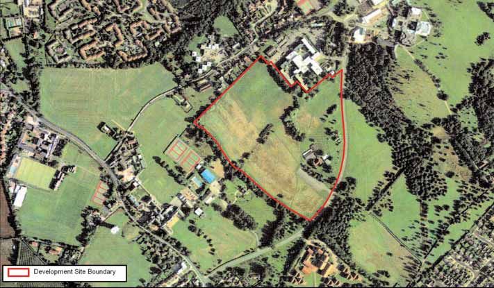
Chapter 1: Introduction                                     iii)   To advise on location and related planning          Deposit Draft Local Plan (2003). At the time of writ-    University campus. The results of the public consul-
                                                                   issues.                                             ing this document it is understood that the Council      tation exercise and proposed revisions to the brief
Background                                                                                                             has not received any significant objections in princi-   made in response to public comments were report-
                                                            1.5 The results of the demand analysis indicated           ple to the development of a new Business                 ed to the Council’s Development Control Committee
1.1 The University of Kent was established at               that on a ten-year view there is potential demand in       Innovation Centre at the University of Kent on           on 17th August 2004. The Development Control
Canterbury in the 1960’s as one of seven new uni-           Canterbury for about 19,000 sqm of accommodation           Beverley Farm, and that there are no proposed            Committee recommended the proposed changes to
versity foundations, on a large 121 hectare site to the     for knowledge-based businesses. Just under half of         changes to the Revised Deposit Local Plan Policy         the document be approved, and subject to some fur-
north-west of the city.                                     the potential demand is directly dependent on hav-         ED7 prior to the Local Plan enquiry.                     ther issues raised by members of the public at this
                                                            ing a site in close proximity to, and preferably part                                                               meeting being addressed, recommended the devel-
1.2 Beverley Farmhouse initially acted as the centre        of, the University of Kent campus. The analysis pre-       1.9 In July 2003 the University of Kent issued a         opment brief to the Executive Committee for
of the new establishment in 1964. The construction          dicts that a significant proportion of the demand will     press release announcing that SEEDA had approved         approval. The development brief was approved by
of the first colleges (Eliot College and the Physics        arise from the successful incubation of knowledge-         a grant of £250,000 to the University following a bid    the Executive of the Council on 2nd September and
Building) began at this time and the first building         based start-up businesses, and is therefore 'home          in partnership with Canterbury City Council to estab-    this was ratified at a meeting of the Full Council on
was completed in 1965, the year in which the                grown'. Incubation capacity is therefore very impor-       lish the Canterbury Enterprise Hub. This will include    16th September 2004. The development brief is
University of Kent received its Royal Charter.              tant for the success of this initiative. The creation of   a business support network, hatchery and incubator       therefore now adopted as supplementary planning
                                                            an effective, well-managed incubator was consid-           space for new businesses in the area. The focus of       guidance (SPG).
1.3 Numerous other academic buildings and stu-              ered to be an early priority, as the first part of any     this will be on innovative companies working in
dent facilities were developed during the 1960's and        knowledge-based business initiative in Canterbury.         health, information and communication technolo-          1.12 The SPG will support the relevant planning
1970's and since then the University has continued                                                                     gies. It is anticipated that the establishment of the    policies in the Canterbury Local Plan and provide
to expand with the addition of new buildings, spe-          1.6 The report also assessed potential develop-            Enterprise Hub will be the catalyst for the wider ini-   additional guidance for future developers of the site.
cialist study units, observatory, nursery, estates          ment locations in Canterbury and analysed the suit-        tiatives outlined above. At the time of writing,         It is anticipated that the Brief will become an impor-
office, business school, studios, sports facilities, stu-   ability of each identified site, as a potential location   SEEDA had appointed a Hub Director for the               tant material planning consideration and provide
dent accommodation, shops, banks, student union             for a new, high-quality employment development             Canterbury Enterprise Hub.                               Canterbury City Council with a detailed development
centre, bookshops and other essential student facili-       associated with knowledge-based sectors, against a                                                                  framework, against which all future planning appli-
ties. The extent of the current University campus is        set of defined site selection criteria. The Beverley       Purpose and format of the brief and                      cations can be assessed and determined.
shown on Figure 1.                                          Farm site, located on the University of Kent campus,       procedure
                                                            was the only site identified that could meet, or par-                                                               Guiding objectives
1.4 Canterbury enjoys the distinction of being the          tially meet, all of the assessment criteria. It was        1.10 This Development Brief has been prepared by
home of three higher education institutions, the            therefore identified as the best possible site for a       Terence O'Rourke Ltd for the University of Kent to       1.13 The overall objectives of the Brief are:
University of Kent, Kent Institute of Art and Design        new 'knowledge/research park' development.                 guide the future development of a new Business
and Canterbury Christ Church University College, all                                                                   Innovation Park to be located at Beverley Farm, and      i) To assist in maximising the potential of the site by
of which have well-established links to the sub-            1.7 Although the adopted Canterbury Local Plan             to comply with the requirements of draft Policy ED7,        providing new development in such a way that
region's further education colleges. Given this sig-        (1998) pre-dates the Angle Technology Ltd report, it       as set out in the Revised Deposit Draft Canterbury          stimulates the start-up of new innovative compa-
nificant local educational resource, Angle                  does recognise the importance of the education sec-        Local Plan (2003). Throughout the document we refer         nies, and the expansion of the knowledge-based
Technology Limited, in association with Terence             tor and the employment opportunities that it gener-        to the ‘Innovation Park’ as opposed to the                  economy, whilst conserving and enhancing the
O'Rourke Ltd, were commissioned by Canterbury               ates. It also notes that several establishments in the     ‘Innovation Centre’. The two have the same bound-           quality of the existing environment.
City Council to explore the possible expansion of the       higher education sector are considering expansion.         ary, however in discussion with the University, the
area's knowledge-based economy. A report was                                                                           City Council and SEEDA it was agreed that                ii) To promote high standards of layout and design
published in January 2002, in association with the          1.8 The First Deposit Draft Canterbury Local Plan          Innovation Park was a more appropriate description           on the site, including the inclusion of innovation
City Council, the South East of England                     (2002) fully recognises the need to exploit and            of the proposed development. The Innovation Park             and good practice in sustainable construction and
Development Agency (SEEDA), the University of               expand the local knowledge - based economy and             will include SEEDA’s enterprise hub and the associ-          resource use.
Kent and Kent County Council, to inform the                 the new business opportunities that could be devel-        ated Innovation Centre buildings as well as provid-
Canterbury District Economic Strategy and Local             oped, as highlighted in the Angle Technology report.       ing buildings for graduates from the Innovation          iii)To promote the integration of the new business
Plan review. The key objectives of the research were        The First Deposit Local Plan introduces a policy           Centre and inward investors wishing to establish at          innovation park with the existing and evolving
                                                            (Policy ED7), which safeguards the Beverley Farm           the Innovation Park.                                         University of Kent campus.
                                                            site for a Business Innovation Centre development,
i)    To quantify and assess the potential for devel-       subject to the preparation of a Development Brief.         1.11 A draft development brief was prepared for con-     iv)To provide additional guidance on the require-
      oping and expanding knowledge-based busi-             The Local Plan confirms that the City Council is firm-     sultation by the University of Kent and approved for        ments of policy ED7 of the revised Local Plan.
      ness in Canterbury and the District.                  ly committed to this initiative and considers this to      consultation subject to minor amendments by mem-
                                                            be a priority for the Council's economic strategy. This    bers of Canterbury City Council on 7th May 2004.
ii)   To investigate the physical development               policy and the Council's continued support for the         Public consultation was undertaken between 18th
      required to facilitate this expansion.                Innovation Centre is carried forward in the Revised        June and 30th July 2004 and this included a public
                                                                                                                       exhibition held in the Foyer of Keynes College on the

                                                                                                                                          UNIVERSITY OF KENT, CANTERBURY                                                             3
                                                                                                    INNOVATION PARK DEVELOPMENT BRIEF – SUPPLEMENTARY PLANNING GUIDANCE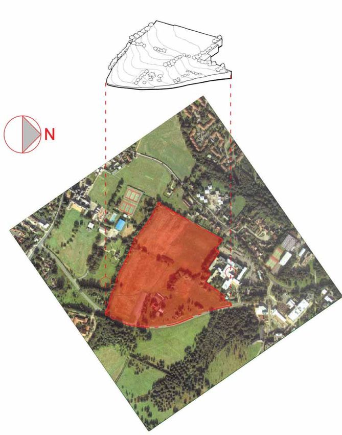
Figure 2 Aerial Photograph                                                                                       Figure 3 Adjacent Land Uses

Chapter 2: Site Context and Description                                                                          Adjacent land uses

Location and size                                                                                                2.2 The majority of the site is undeveloped, the only built development being Beverley Farmhouse and its
                                                                                                                 associated outbuildings and car parking, which together are located on the eastern site boundary. The site is
2.1 The site is located on the north-western edge of Canterbury and forms part of the main University of Kent    bordered by a mix of land uses to the north, west and south, the majority of which are related to education
campus (Figure 1). The site is approximately 1.8 km from the city centre and extends to approximately 6.5        (Figure 3).
hectares (16 acres) in area. The site occupies land on the south-east facing University slopes on the northern
side of the Stour Valley. The full extent of the site is shown on the aerial photograph (Figure 2).              2.3 The south-eastern boundary of the site is defined by University Road, which curves northwards around the
                                                                                                                 Beverley Farm buildings. The boundary with University Road is largely undefined at this point with no fencing
                                                                                                                 or hedgerow. Land beyond the road to the south east of the site is generally characterised by an area of main-
                                                                                                                 tained grassland and parkland, which slopes down towards the city. To the south of the site and University Road
                                                                                                                 lies Chaucer College, which is well screened from view by an existing dense belt of vegetation.

                                                                                                                 2.4 The south-west site boundary is defined by a broad belt of mature trees of mixed species and shrubs that
                                                                                                                 marks the route of a small stream. Beyond this lies St Edmund’s School and its playing fields. To the north-east
                                                                                                                 lies Keynes College, the boundary of which is characterised by mature mixed planting, including oak and wil-
                                                                                                                 low species.

                                                                                                                 2.5 To the north of the site lies a range of university buildings, together with some private properties, fronting
                                                                                                                 onto Giles Lane. Further away to the north of Giles Lane is the Park Wood Courts area of student residential
                                                                                                                 accommodation.

4              UNIVERSITY OF KENT, CANTERBURY
               INNOVATION PARK DEVELOPMENT BRIEF – SUPPLEMENTARY PLANNING GUIDANCE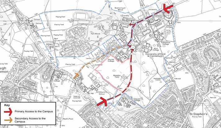
Figure 4 Topography                                                                                                Figure 5 Access to the Campus

Topography                                                                                                         Access to the University campus

2.6 The basic site topography is shown in Figure 4. Although the north corner of the site is relatively flat the   2.8 The site is accessed off University Road, which adjoins the Whitstable Road about 300m to the south-west,
site then slopes down south eastwards from the 65m contour towards the University Road and the Beverley            at St. Thomas Hill. Whitstable Road forms part of a north-south route from Whitstable into Canterbury city cen-
Farm buildings at between 50m and 55m above ordnance datum (AOD). In the southern-most corner of the site          tre. There are two points of access to the campus. The first is from Whitstable Road into University Road as
the level drops to 43.5m AOD. This represents a fall of approximately 21m from the flat area to the north down     shown on Figure 5. This road gives direct access into the heart of the campus. The site is therefore an important
to the box culvert under University Road.                                                                          gateway site because of its location directly adjacent to one of the main road entrances to the University cam-
                                                                                                                   pus.
2.7 The majority of the site occupies a gentle promontory situated between two valley features. The western-
most of these which runs along the boundary with St Edmund's School, is more pronounced and is occupied            2.9 The second access is from St Stephen’s Hill, via Giles Lane. Giles Lane leads into the University campus
by a stream. The eastern-most is far more shallow and is part occupied by the Beverley Farm buildings.             linking with University Road. St Stephen’s Hill also forms part of a north-south route from the Whitstable area
                                                                                                                   (Chestfield and Swalecliffe) to Canterbury city centre. The University can also be accessed from Whitstable Road
                                                                                                                   via Giles Lane at its western end, although this access is very narrow.

                                                                                                                   2.10 The Beverley Farm car park is un-screened and cars parked in this area are clearly visible from University
                                                                                                                   Road and much of the surrounding area.

                                                                                                                   2.11 In terms of public transport the campus is well served by a number of different bus routes linking to the
                                                                                                                   city centre, the rail station and other destinations. The closest rail station is Canterbury West, located on the
                                                                                                                   north-western edge of the city and therefore well located for travel to the campus by bus. Cycle path and pedes-
                                                                                                                   trian facilities also exist serving the main University campus.

                                                                                                                                       UNIVERSITY OF KENT, CANTERBURY                                                             5
                                                                                                 INNOVATION PARK DEVELOPMENT BRIEF – SUPPLEMENTARY PLANNING GUIDANCE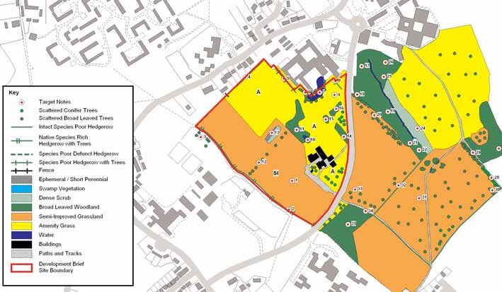
Figure 6 Agricultural Land                                                                                           Figure 7 Archaeological Survey

Agriculture and land management                                                                                      2.15 The study notes that previous discoveries, both within the University campus and in the immediate vicin-
                                                                                                                     ity, show that despite zones of earlier disturbance by various farming processes and later landscaping, impor-
                                                                                                                     tant and significant archaeology still survives in localised areas within the wider landscape. In particular, pre-
2.12 The majority of the site is under grass and is cropped for hay. There are also mown grass paths across the      historic activity and settlement evidence is widely dispersed over the area and there are significant remains of
site and a single line of outgrown hedgerow vegetation, crossing the site from the south-west to north-east,         medieval pottery and tile kilns from the key elements of the important medieval ceramics industry scattered
which divides the site into two parts.                                                                               across this landscape.

2.13 The site is classified as land predominantly in urban use on the agricultural land classification maps, pro-    2.16 The study concludes that there is a likelihood that elements of prehistoric activity and settlement, related
duced by the former Ministry of Agriculture, Fisheries and Food (MAFF now DEFRA). However, the undevel-              directly to the known foci of settlement in the Sarre Penn valley and close to St Edmund’s School, have been
oped parts of the site are likely to be of grade 3 quality given that the immediate surrounding area is also grade   preserved within the confines of the proposed areas of development within the campus. The location of archae-
3 agricultural land (Figure 6).                                                                                      ological finds on and adjacent to the Development Brief site are shown in Figure 7. There is also a likelihood that
                                                                                                                     further medieval tile and pottery kilns, together with other elements of the medieval and later ceramics indus-
                                                                                                                     try, may occur on the University campus.
Heritage and archaeology
                                                                                                                     2.17 Beverley Farmhouse is a grade II listed building. The central core of the existing farmhouse is a 15th cen-
                                                                                                                     tury timber framed building, with studding to the first floor. The eastern section is 16th, or early 17th, century
2.14 An archaeological and historical desk-based survey was undertaken by the Canterbury Archaeological
                                                                                                                     timber framed with brick infilling. The oldest part of the house is 'L' shaped in plan and was built over two
Trust in 2003, to assess the archaeological potential of the whole University campus. Although the study area
                                                                                                                     storeys with four windows. During the nineteenth century a large wing was added to the west giving the build-
covered the entire University of Kent campus, including the land the subject to this Brief, it was not specifical-
                                                                                                                     ing a 'T' shape in plan comprising two to three storeys with a red brick base, and faced with fish scale tiles.
ly commissioned to assess the potential of the proposed Business Innovation Park site.

                                                                                                                     2.18 In 1963 Beverley Farmhouse was purchased as part of the new University. The old dilapidated out-build-
                                                                                                                     ings were replaced by new pre-fabricated timber building in 1964. Extensive restoration work was carried out
                                                                                                                     on the building in the 1990's.

                                                                                                                     2.19 Canterbury Archaeological Trust has produced a comprehensive report for the entire University Campus.

6              UNIVERSITY OF KENT, CANTERBURY
               INNOVATION PARK DEVELOPMENT BRIEF – SUPPLEMENTARY PLANNING GUIDANCE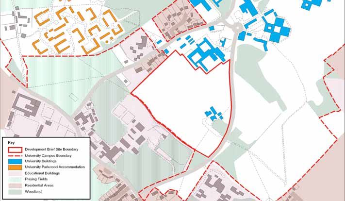
Figure 8 Ecology Survey                                                                                               Figure 9 Geological Survey

Nature conservation                                                                                                   Ground conditions

2.20 An ecological survey of the site was undertaken by Terence O'Rourke Ltd in July 2003, and the site was           2.23 The solid geology of the site comprises Tertiary London Clay, which sits above the Oldhaven Beds (Figure
mapped according to the standard Phase 1 survey technique, as recommended by English Nature. The findings             9).
are shown in Figure 8. The site is characterised by a mix of semi-improved hay meadows, amenity grassland
with scattered trees and small stands of scrubby woodland. There are also two ponds on site. The full ecologi-        2.24 The majority of the site is undeveloped land and is unlikely to contain any significant contamination.
cal report is included for reference in Appendix A.

2.21 Features of wildlife interest include the hedgerow bordering the west of the site and a number of broad-
leaved trees. The two ponds on site were found to contain limited wildlife interest at the time of survey. No signs
of badger activity were recorded and no bat roosts were identified. However, a number of the mature trees and
the roof space of Beverley House could provide a suitable environment for bat roosts.

2.22 The site is not designated or listed as being of any significant nature conservation interest and no rare,
scarce or protected species were recorded during the survey.

                                                                                                                                          UNIVERSITY OF KENT, CANTERBURY                                                            7
                                                                                                    INNOVATION PARK DEVELOPMENT BRIEF – SUPPLEMENTARY PLANNING GUIDANCE
Figure 11 Distribution of Existing Vegetation

                                                                              Distribution of existing vegetation
                                                                              (from the Lloyd Bore Landscape Appraisal)

                                                                              2.25 Areas of vegetation across the site are:
                                                                              Area 1: Area of mown grass used for hay covers most of the appraisal site.
                                                                              Area 2: Mixed deciduous tree belt ranging from from 8m to 20m in height. Predominantly semi-mature and
                                                                                        mature Ash and Oak, some of which stand up to 30m in height. Some Hazel, Alder, Field Maple and
                                                                                        Willow, with occasional Birch, Whitebeam, Elder, Damson and Dogwood. This area also contains a
                                                                                        number of ornamental maples eg Acer saccharinum, where areas 2 and 3 converge. Some Oak, Hazel
                                                                                        and Alder saplings (apparently self seeded) lie to the front of the tree belt with common species such
                                                                                        as blackberry, nettle, bramble and ivy in the understorey.
                                                                              Area 3: Small band of trees and young shrubs dividing Area 4. Some mature trees which stand approxi-
                                                                                        mately 10 to 15m in height are of significance (e.g. Oak, Sycamore and Acer) which stand.
                                                                              Area 4: Area of amenity grass cut to facilitate sports activities such as football and hockey.
                                                                              Area 5: A mature band of Oak and Beech, between 25 and 30m in height and extensive ivy growth, provid-
                                                                                        ing a screen between Keynes College and the site area.
                                                                              Area 6: Mixed group of trees, predominantly maturing Willow species (including babylonica, viminalis, and
                                                                                        caprea), with some Hawthorn, Holly and Dogwood. Other mature Oaks on the south west side reach
                                                                                        heights of up to 25/30m.
                                                                              Area 7: Ornamental conifers, willows, and reeds line the margin of a small lake next to Keynes College.
                                                                              Area 8: Extensive area of maintained activity grass, typical of the university grounds, with scattered clusters
                                                                                        of mixed deciduous and coniferous tree planting.
Figure 10 3D View of Site Area                                                Area 9: Beverley Farmhouse, situated amongst mixed planting including Silver Birch, Fir and Blackthorn.

8              UNIVERSITY OF KENT, CANTERBURY
               INNOVATION PARK DEVELOPMENT BRIEF – SUPPLEMENTARY PLANNING GUIDANCE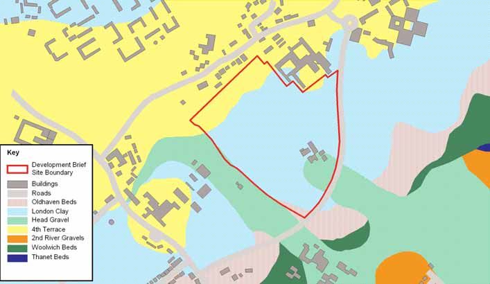
Figure 12 Views from site to City Centre                                                                            Figure 13 Views from adjacent areas

Views

2.26 An extensive assessment of views was undertaken by Lloyd Bore Landscape Architects between August
and October 2002. A full record of their findings is included within their report dated January 2003.

2.27 The key characteristics of the views to and from the site area are illustrated on figures 12 to 14. They can
be summarised as follows:

Figure 12: The upper parts of the site, as with many areas of the University slopes, provide the broadest and
most unhindered views south-eastwards over the city centre. Views westwards towards St Edmund’s School
are interrupted by a dense band of vegetation on the south-western boundary. From the lower part of the site
around Beverley Farmhouse the views are interrupted by existing vegetation.

Figure 13: From University Road views of the upper part of the site are not possible due to the ridge and tree
line as indicated on the drawing. The remaining views are typical of the University slopes being a landscape of
open grass fields partitioned by belts of mature trees on gently sloping land.

Figure 14: The upper levels only of the appraisal site are visible from several locations around Canterbury city
centre.

2.28 From the above analysis it is evident that development of the upper section will potentially be visible from
a number of distant viewpoints across the city, particularly from the south and south-east. It is noted, howev-
er, that development here would be consistent with the pattern of existing campus development at the
University.

2.29 Development on the lower part of the site, in the vicinity of Beverley Farmhouse and the area to the west      Figure 14 Distant views
of it, would appear to have less visual impact on these distant views. In terms of views from the site, general-
ly the higher the vantage points, the more expansive and spectacular the views across the city.

                                                                                                                                        UNIVERSITY OF KENT, CANTERBURY   9
                                                                                                  INNOVATION PARK DEVELOPMENT BRIEF – SUPPLEMENTARY PLANNING GUIDANCE
Figure 15 Context
Contextual analysis - relationship with 2.32 Thirdly, St Edmund’s School lies to the west Planning history
comprising a mix of original building with new
the campus development, in particular the new Sports Facility
with a distinctive blue metal cladding. The school is 2.34 Planning permission was originally granted for
2.30 The site area is immediately adjacent to three
effectively screened from the site by the strong belt development of the University in the 1960's and
principal building areas of development. Firstly,
of trees which extends along the length of the much of the development of the campus took place
Keynes College to the east is a four storey mixed-use
boundary. at that time, although some further development has
university building consisting of wings of student
taken place since. Much of the Development Brief
residences, teaching spaces and amenity/social
2.33 The combined impression of the built develop- site remains undeveloped and hence the only plan-
accommodation. It comprises a variety of different
ment on the University site is of a horizontal mass- ning history for the Beverley Farm site relates to the
building materials with a mixture of timber, pre-cast
ing with strong vertical elements such as glazing, siting of Portakabins and double garage.
concrete blocks and panels, mixed aggregate panels
projecting bays and entrances.
and aluminium glazing. Access is possible to the site
2.35 The most recent planning history at the adja-
via the rear car park of the college.
cent Keynes College relates to the erection of a 3-
storey psychology building comprising lecture the-
2.31 Secondly, a mixture of private residential prop-
atre and teaching and research accommodation. An
erties are situated to the north of the site and have
initial application for 1860 sqm was granted plan-
views over it. It will be important that this local
ning permission on 21st May 1999 (99/00366), and a
amenity is protected against excessive noise, light
revised application for 909 sqm was granted plan-
pollution as well as against overlooking from new
ning permission on 11th February 2000 (99/01157).
development.
10 UNIVERSITY OF KENT, CANTERBURY
INNOVATION PARK DEVELOPMENT BRIEF – SUPPLEMENTARY PLANNING GUIDANCEChapter 3: Site Constraints and tainable buses, fuelled by hydrogen gas (generated University Road, which would then link into a therefore does not offer a more attractive route than
from photovoltaic cells and electrolysers incorporat- redesigned Beverley Farm car park. This approach the off-road cycle path.
Opportunities Analysis
ed into the new development), which would reflect would introduce a further opportunity to improve
the innovative activities taking place at the new busi- and enhance the setting of Beverley Farmhouse.
Access and highways ness centre. This would require further investigation
and funding from other sources.There is also the 3.8 Given the visibility of the site from the sur- Pedestrians
opportunity to work with the County and City rounding area, an access road from University Road, 3.11 Pedestrian access to the campus via the
3.1 WSP Development was commissioned by the
Councils to provide a park and ride facility offsite as serving the central and northern parts of the site Whitstable Road/University Road junction is not
University of Kent to undertake an Initial Transport
part of a more general public facility. Public transport could, depending on its location, form and configu- ideal because of the steep gradient on Whitstable
Appraisal for the proposed Business Innovation
links from that location to the Innovation Park and ration, be damaging to the landscape. However, an Road and the lack of footway on the southern side of
Park. The full technical report is included in Appendix
campus could remove significant numbers of private opportunity exists to develop a new access road off University Road forcing pedestrians to cross at the
C. The Initial Transport Appraisal reviewed the over-
car journeys from the local road network around the University Road, north of Beverley Farmhouse, that junction. However, there is pedestrian access to the
all scale of travel demands from the proposed devel-
university. The university can influence the numbers would follow the contours of the land resulting in a campus off the carriageway along the same route as
opment. It considered the constraints to access and
of car journeys to the campus by the parking man- reduced visual impact on the landscape. There may the good existing cycle path network. This offers a
opportunities for mitigation. It also set out a
agement regime, thereby reducing traffic flows to be a need for an emergency access to the northern direct link from Canterbury West Station.
methodology for assessment of impacts at planning
application stage. In order for the proposed devel- the site. This issue would be addressed by the Travel part of the site when development is complete. The
opment to be acceptable in planning terms it is nec- Plan. opportunity exists to provide a restricted gated Landscape and visual
essary to demonstrate that the adjoining road net- access either from Keynes College to the east or
3.12 A landscape appraisal was carried out by Lloyd
work is capable of supporting it. 3.4 There are also constraints imposed by existing from Giles Lane to the north. However, any new
Bore Landscape Architects in January 2003, to con-
road junctions. The junction of the A290 Whitstable access to Giles Lane would be controlled by means
sider the specific landscape characteristics of the
Local road network Road and University Road is a priority junction and of a locked gate, and would only be accessible to
site, and its ability to accommodate development in
3.2 The local road network in the vicinity of the has a right turn storage lane. There is limited scope emergency vehicles. Provision of suitable access at
the form of a new Business Innovation Centre.
University campus is close to capacity, particularly for improvement of this junction due to the gradient these points for pedestrian and cyclists will be
during the morning and afternoon peak periods. The of Whitstable Road and signalisation would not be expected.
3.13 The appraisal draws upon the Canterbury
traffic flows on the Whitstable Road radial route are desirable. The capacity of this junction would require
Public transport Landscape Appraisal (November 1998), prepared by
tidal with flows heaviest and close to capacity south- assessment as part of the Transport Assessment to
3.9 Although the campus is well served by bus and Kent County Council's KPS Landscape Group, on
bound in the morning peak as people make their demonstrate that it would function safely with the
several schemes exist to assist and encourage staff behalf of the City Council. This landscape appraisal
way to work, and the reverse in the evening as traf- development in place.
and students to use local bus services, further notes that the site is located within a character area
fic makes its way northbound out of the city centre.
opportunities may exist to make improvements to referred to as the Stour Valley Slopes. This area is
Initial trip generation calculations indicate that the 3.5 The junction of the A290 Whitstable Road and
these schemes and to provide incentives to encour- defined as follows:
road network in the immediate vicinity of the Giles Lane is constrained and is not a suitable access
for any significant amount of traffic due to its narrow age a greater modal shift from private vehicles.
University campus is already close to capacity dur-
Furthermore, opportunities exist to improve the bus “The Stour Valley Slopes rise above the Stour Valley
ing peak periods and therefore is unlikely to be able width at this point. The operation and capacity of the
infrastructure, such as shelters and timetable infor- forming a very definite ridge which contains
to accommodate all of the vehicle trips likely to be Giles Lane junction with St Stephen’s Hill and
mation, on the campus which at present is very poor, Canterbury along its Northern western flank. The
generated by the development of the Beverley Farm Canterbury Hill has already been improved but
to promote bus travel as an attractive mode of trav- area stretches from Rough Common in the west to
site without some mitigation measures. would not be suitable for any further significant
el. The existing usage of public transport, and meas- Broad Oak in the east. Where the Stour Valley Slopes
increase in traffic due to the gradient of Canterbury
ures to encourage a transfer from car travel to bus are undeveloped these slopes are usually grassed
3.3 It is likely, therefore, that there would be a need Hill.
travel would be evaluated within the Transport either as playing fields, amenity land or pasture. The
to transfer some of the newly created trips, as well
Assessment. agricultural land classification is mostly grade 3 with
as some existing trips to other modes of travel, such 3.6 To serve the proposed development area, a
small pockets of grade 2 on the lower slopes
as public transport, walking and cycling. These new access will need to be taken from University
Cycling towards Broad Oak where the soils are of better agri-
should together form the basis of a University Travel Road, either from the current access to the Beverley
3.10 Although Canterbury has a good cycle path net- cultural quality”.
Plan which would form an integral part of the Farm buildings, or via a new access road taken from
another suitable point further east along University work, access to the campus from Whitstable Road
Transport assessment at application stage. Potential
via the junction with University Road is not suitable 3.14 The emerging Canterbury District Local Plan
opportunities exist to incorporate a ‘Park-and-Ride’ Road.
for cyclists due to the steep gradient and the difficul- identifies the Stour Valley, including the develop-
facility into the development to be used by occupiers
ty in manoeuvring across oncoming traffic from a ment site, as an Area of High Landscape Value
of the Business Innovation Park, staff and students 3.7 The existing Beverley Farmhouse car park
stationary position. The cycle path from Canterbury (AHLV) under Policy R6. In addition to areas of high
travelling to the campus and potentially by other access is not screened and the cars parked there are
West, which links to the city's cycle path network landscape quality, the landscape designation seeks
road users travelling from the Whitstable area to prominent in views from the University Road and
into the centre of the campus is a far safer route as to protect features of archaeological heritage, includ-
Canterbury city centre, thus reducing the number of much of the surrounding area. The creation of a new
it is off the carriageway and is easier for cyclists to ing the historic setting of Canterbury and the World
vehicles on Whitstable Road between the University access from University Road would provide an
negotiate. The junction of Giles Lane with St Heritage Site. The Lloyd Bore assessment notes that
and the city centre. The Park-and-Ride could provide opportunity to reconfigure the existing access and
Stephen’s Hill and Canterbury Hill is not particularly the Canterbury Landscape Appraisal describes the
an opportunity to introduce environmentally sus- car park arrangement, either by redesigning the
suitable for cyclists because of the gradient and condition of the Stour Valley Slopes as moderate,
existing access, or by providing a new access off
UNIVERSITY OF KENT, CANTERBURY 11
INNOVATION PARK DEVELOPMENT BRIEF – SUPPLEMENTARY PLANNING GUIDANCEalthough in some areas this is considered to border ● Strengthen the boundary on the edges of Hales Terence O'Rourke in July 2003 found that the only 3.25 The desk-top appraisal has established that the
on poor. It also notes that many of the area’s distinc- significant features of wildlife interest on the site site may contain preserved archaeological remains
tive features have been lost to development or have ● Locate estate in a manner that reflects the his- were the hedgerow bordering the west of the site although there is no evidence to suggest that the
become eroded though neglect. However, the tradi- toric connections and a number of broad-leaved trees. The two ponds proposed development site at Beverley Farm has
tional landscape of the Stour Valley is still evident were found to have no obvious wildlife interest and any particular archaeological significance.
despite the recent changes, and therefore much of ● Strengthen and recreate the traditional field there were no obvious signs of badger activity, or
the area is classified as having a high level of sensi- pattern bat roosts on site during the survey. However, given Topography
tivity to change. the time of the ecological survey and its limited
● Conserve and restore open grass slopes over- nature, this should not be taken as conclusive evi- 3.26 The topography imposes significant restraints
3.15 The Lloyd Bore appraisal considered views looking the city dence. on the maximum development potential of the site.
from key publicly accessible locations around the
city. If found that the site is visible from several loca- ● Resist further fragmentation 3.22 The mature trees on site, particularly those 3.27 In particular, areas to the west boundary, where
tions around Canterbury city centre. There are also a adjacent to the western boundary and stream, and gradients are as steep as 1:5, are not considered to
number of landmarks close to the site, including the ● Strengthen the structure of the field pattern on the exterior and internal spaces associated with be capable of viable commercial development.
Water Tower, St Edmunds's School, the various the slopes beneath the University, resisting the Beverley Farmhouse could provide ideal habitats for These areas have therefore been zoned for amenity
University college buildings and the radio mast at further introduction of scattered ornamental bat and bird roosts. Furthermore, the water bodies space.
the school of Electronic Engineering, which are easi- planting may reveal the presence of reptiles, invertebrates
ly identifiable from these locations. In general, views and protected amphibians, such as Great Crested 3.28 In addition, the general principle of develop-
towards the site are most commonly afforded from ● Resist the introduction of dominant features on Newts. Therefore, it will be necessary for appropri- ment apparent over the remainder of the University
due south and south east of the city in locations the visually sensitive skyline. ately qualified experts to undertake a more detailed site has been adopted in respect to the setting of
where the land rises higher than the city centre, thus ecological surveys, in line with English Nature development on the ridge line with a front apron of
providing a vantage point towards the Stour Valley guidelines, to investigate the presence, and popula- grassy slopes. The highly visible area of grassland
Slopes. Cultural heritage tion size of any protected species on, or immediate- just below the ridge line has been maintained as
ly adjacent to the site. The information obtained from open amenity space. This strategy has resulted in the
3.16 The northern or upper part of the site is visible 3.19 The grade II listed Beverley Farmhouse is the this survey work will be required to support any requirement for a high density of development on
from locations around the city centre, whilst the only permanent building on site. It is important that future planning application. Where necessary an the flat plateau to the northern area of the site.
southern and western parts are not visible due to a the setting of this listed building is protected. appropriate ecological mitigation strategy will be
dense band of vegetation on lower parts of the However, there may also be some opportunities to expected to ensure that both terrestrial and aquatic Hydrology/drainage
University slopes. enhance its setting, particularly with regard to the habitats, used by protected species, are conserved
removal of a number of the unsympathetic adjacent as part of any development proposals. 3.29 An initial assessment of existing and future sur-
3.17 Development on the upper section of the site temporary buildings which are now in a poor state of face and foul water drainage was carried out by WSP
would potentially be visible from a large number of repair. The presence of Beverley Farmhouse and 3.23 There may be some opportunities to improve Development in 2003. The key findings of this study
distant viewpoints across the city, particularly from consideration of its setting will therefore have a sig- and enhance the parts of the site with nature con- are summarised below.
the south and south east, and would therefore need nificant bearing on the nature and design of any new servation interest, such as the hedgerow and mature
to be carefully designed to reflect the existing pat- development that might take place in proximity to trees along the site boundary and these should be Surface water
tern of built development on the University campus the building. further investigated. 3.30 The University is drained by a network of pri-
Development on the lower part of the site would vate drainage pipes which outlet to water courses
have less impact on these distant views, although Nature conservation Archaeology
and the public surface water drainage system
this would be dependant on the height of the pro- around the site. The adjacent Keynes College and the
posed new buildings. 3.20 The Canterbury Landscape Appraisal describes University medical centre drain via a pipe which
3.24 An archaeological and historical desk-based
the nature conservation interest in the Stour Valley flows alongside University Road and collects the
survey undertaken by the Canterbury Archaeological
3.18 Although landscape sensitivity and views from Slopes area as follows: road drainage from University Road. This pipe out-
Trust in 2003 found that there was a likelihood that
the city are constraints upon development it is con- lets into the water course at the downstream side of
elements of prehistoric activity and settlement, relat-
sidered that there are also significant opportunities “Traditionally the Stour Valley Slopes would have the site. Part of the roof drainage from Keynes
ed directly to the known foci of settlement in the
to site and design a new business innovation park been a pastoral landscape divided by hedgerow and College appears to feed a pond on the south side of
Sarre Penn valley, and close to St Edmunds School,
complex which respects the landscape character, woodland blocks. The pattern of this landscape is still the College. This pond is ornamental and would have
have been preserved in the general area. It was also
whilst also achieving some of the following appro- evident today although often fragmented by recent only a limited balancing capacity.
concluded that there is a likelihood that further
priate actions for the Stour Valley Slopes, as set out changes in land use. The planting of inappropriate
medieval tile and pottery kilns, together with other
in the Canterbury Landscape Appraisal Plan. These species in and around playing fields and scattered 3.31 There is another smaller pond to the north west
significant elements of the important medieval
are: ornamental trees in amenity areas such as the of Beverley Farm. An outfall pipe from this pond
ceramics industry, which may continue into the
University have eroded the traditional vegetation diverts the outflow from it around the south-west
early-mid post medieval period, may also occur on
● Encourage the restoration of the historic park- patterns and fragmented wildlife corridors.” side of Beverley Farm and into the drainage in
the University campus.
land planting University Road.
3.21 An ecological assessment undertaken by
12 UNIVERSITY OF KENT, CANTERBURY
INNOVATION PARK DEVELOPMENT BRIEF – SUPPLEMENTARY PLANNING GUIDANCE3.32 Canterbury City Council has indicated that Drainage - design and landscape Security and public access
Salisbury Road, approximately 500 metres the south 3.42 There are a number of public footpaths cross-
considerations
east of the site and directly downstream of it on the ing the site. Footpath CC5 runs along the western
water course described above, is susceptible to 3.38 The rate of surface water run-off from the site boundary, whilst footpath CC68 runs parallel to
localised flooding during periods of wet weather. In developed site will be greater than that which arises the University Road boundary. The general public
light of the flooding problems downstream of the from the existing undeveloped site. This must be also has unrestricted access across the University
site the runoff rate from the site should be limited to controlled to avoid adverse impacts to areas border- slopes. The issues of continued public access and
a rate equivalent to the existing green fields. ing the watercourse down stream of the university. site security must be taken into account in the
This is normally carried out by restricting the rate of design and site layout. Access and security must be
3.33 Surface water run-off will drain to the existing run-off from the site to the level agreed with the considered in the context of the adjacent school, the
ditch, which forms the south-west boundary of the Environment Agency and storing the balance on site proposed Business Innovation Park and the public
site. for slow release on the downstream watercourse. footpath network. Consideration must also be given
to the security and safety of the public and students
Foul drainage 3.39 However, due to the open nature of the campus when using these spaces.
3.34 The existing foul drainage system comprises a and proximity to residential areas, public safety
network of private sewers, most of which connect to associated with any proposed open balancing facili- Architectural context
a main outlet pipe which discharges eastwards to the ties is a primary consideration and detailed propos- 3.43 The Lloyd Bore landscape appraisal concludes
public sewer in St Stephen’s Hill. Hothe Court als demonstrating how public safety has been that the existing campus architecture provides a con-
Farmhouse in the north-west corner of the campus addressed will need to be agreed with Canterbury text for discussion of the style of any future devel-
discharges westwards into the public sewer in City Council. Whichever option of surface water opment on the site. It notes that the University build-
Whitstable Road. retention is used, the design should incorporate ings provide a strong massing on the Stour Valley
measures to minimise the run-off rate of the site, to Slopes, many of which form a strong backdrop to
3.35 The outlet pipe from Keynes College runs down
allow for infiltration into the ground where practica- views across Canterbury. The Lloyd Bore landscape
University Road on the eastern boundary of the site
ble. It will also include measures to improve the analysis also found that the buildings have a strong
to a point adjacent to Beverley Farm, where it is
quality of run-off before discharging into the water horizontal form, which is often punctuated by strong
joined by the outlet pipe from Beverley Farm. A pipe
course. vertical features, such as stair wells, which provide a
runs from this point eastwards and northwards to
‘rhythm’ to the elevational treatment of the architec-
connect with the main outlet pipe from the
3.40 An initial estimate of the storage volume ture. The report notes that this powerful architecture,
University at a point approximately 400m east of the
required if ponds / swales were to be provided as set on the horizon above the city, is a familiar local
eastern boundary of the proposed development site.
part of a landscape and drainage scheme would be landmark, in the same way as the distinctive profile
3.36 The new development would need to discharge 500 cubic metres to provide for the initial phase and of the water tower and St. Edmund's School.
to the public sewerage system and appropriate con- a total of 3,000 cubic metres to provide for the whole
sents would be required from Southern Water site. With an approximate depth of a pond / swale at 3.44 The water tower is considered to be a prime
Services (SWS), who would need to assess the 1m and typical 1:2 side slopes, the footprint of a dry example of a vertical feature and light colours con-
capacity of the receiving system. The initial phase of pond to service the initial phase of development trasting with the surrounding landscape to create a
development would be drained by gravity to a would be approximately 900 square metres. distinct landmark feature. Whilst the constraints
pumping station located near the southern corner of imposed by the existing architectural context must
the site. The pumping station would pump either to Residential amenity be respected, an opportunity exists to develop a
the existing University system in University Road, 3.41 The northern part of the site abuts private resi- design that takes an innovative approach to archi-
discharging eastwards into the public sewer in St dential dwellings on Giles Lane and student accom- tecture, engineering and landscape design.
Stephen's Hill, or westwards on University Road to a modation associated within Keynes College, both of
connection with the public sewer system in which have views across the site. Impact on residen-
Whitstable Road. tial amenity is a potential constraint on the upper
parts of the site, where issues of excessive noise,
3.37 Future development phases could drain by light and potential overlooking from new develop-
gravity to either the existing University system, or to ment will all need to be carefully considered and
the pumping station constructed during the initial fully addressed. Any future planning application will
phase. However, capacity checks would be required need to demonstrate that suitable technology will be
both of the University private system and the SWS installed to minimise to an appropriate level any
public system. impact from lighting.
UNIVERSITY OF KENT, CANTERBURY 13
INNOVATION PARK DEVELOPMENT BRIEF – SUPPLEMENTARY PLANNING GUIDANCEChapter 4: Policy Context Regional Planning Policy The Development Plan 4.14 Paragraph 7.43 states that the B1 guidelines for
Canterbury reflect the scale appropriate to the
National Planning Policy 4.4 The regional planning context is provided by Kent Structure Plan labour needs of the area and could be supported by
Regional Planning Guidance for the South East 4.9 The Kent Structure Plan Third Review (to 2011) the local labour market. The guidelines have been
4.1 The Government has published a series of (RPG9). The most recent version of RPG9 was pub- was adopted in December 1996. A key objective of set at a level to allow scope for economic stimula-
planning policy guidance notes (PPGs), intended to lished in March 2001 and sets the framework for the the Structure Plan is to promote economic develop- tion and selective urban renewal without breaching
provide the background to most aspects of the plan- period up to 2016. This guidance supersedes the ment in east Kent, reflecting the perceived scope for conservation constraints. The implementation of
ning system. PPG guidance is reflected at the region- Regional Planning Guidance for the South East economic growth and development. these guidelines must be considered in the context
al and local level in Kent through Regional Planning issued in March 1994, which covered the period up of the overall strategy for the city which is to protect
Guidance, the Kent County Structure Plan and to 2011. 4.10 The Structure Plan acknowledges the impor- and enhance its environment.
Canterbury District Local Plan. tance of continuing to develop the Kent economy. It
4.5 Revised RPG9 reaffirms the Government's com- recognises that the selective provision of land for 4.15 Policy ED2, which relates to the quality of
PPG1 General Policy and Principles mitment to the expansion of the higher education new economic development on a sufficient scale employment development, requires that allocations
sector. Policy RE2 notes that human resource devel- and at appropriate locations is necessary to ensure for economic development in Local Plans are made
4.2 PPG1 promotes the principle of sustainable opment should be recognised as a central compo- the levels of inward investment and job creation following a detailed assessment of the availability
development to secure higher living standards while nent in harnessing and promoting future economic required by the Kent workforce. The main focus of and quality of commitments in the area.
protecting and enhancing the environment. success in the region and that access to job oppor- this new employment generating activity should be
Development should seek to conserve cultural her- tunities should be improved for those who are dis- east Kent.
itage and natural resources, taking care to safeguard advantaged in the labour market. It states that:
designations of national and international impor- 4.11 The strategic policy for east Kent (Policy S4) is
tance. Development should be designed to a pattern “development plans should include policies which to stimulate economic activity and create new
that helps to minimise the need to travel. PPG1 also ensure that sufficient and accessible premises are employment opportunities, whilst recognising the
notes that good design can help to promote sustain- available for training and education purposes…local environmental constraints which apply. However, it
able development, improve the quality of the exist- authorities should consider how they can support is recognised that all urban areas of east Kent have
ing environment, attract business and investment, similar measures to those already employed by a role to play in achieving this objective and attract-
reinforce civic pride and a sense of place, and secure some of the best universities and colleges in estab- ing new inward investment.
the public's acceptance of necessary new develop- lishing effective links with knowledge based indus-
ment. tries.” 4.12 Paragraph 3.65 of the Structure Plan acknowl-
edges that Canterbury's economy and image is
PPG13 Transport 4.6 Amongst other issues, Policy RE5 encourages enhanced by the presence of the University of Kent,
4.3 The objectives of PPG13 are to reduce the need development plans to investigate the scope for mix- which provides a higher education facility of interna-
to travel by integrating planning and transport at all ing employment uses with other land uses including tional repute. The Structure Plan also notes that the
levels to promote sustainable choices and accessi- education. continued success of the university should be fos-
bility by modes of transport other than the car. It is tered and that future expansion plans are a matter
recognised that higher and further education estab- 4.7 Policy RE9 requires active encouragement of which Canterbury City Council should address in its
lishments are major generators of travel and should high value-added activities. Including the grouped Local Plan.
be located to maximise their accessibility for public location of such activities in business clusters, where
transport, walking and cycling. Similarly, proposals economically beneficial and environmentally accept- 4.13 Policy ED1 makes provision for a total of
to develop, expand or redevelop existing sites able. The policy requires development plans to 120,000m2 of floor space for A2/B1 between 1991
should seek to improve access by public transport, encourage existing and emerging clusters and to and 2011. However, in each District Council area the
walking and cycling. promote the diffusion of innovation throughout the precise mix of development to be provided is a mat-
region. It also notes that this could be achieved by ter for the local planning authorities to determine in
identifying science and technology parks that are the light of specific local circumstances. In addition,
well served by sustainable modes of transport and the policy states that in making provision for eco-
close to universities or other research facilities. nomic development:
4.8 Policy RE10ii seeks to encourage the provision “At the historic city of Canterbury, the protection and
of a range of sites in support of small and medium enhancement of the historic environment of the set-
enterprises from a variety of economic sectors, tlement, and its setting, will be the overriding con-
including incubator units and innovation centres in sideration.”
order to help encourage economic diversity.
14 UNIVERSITY OF KENT, CANTERBURY
INNOVATION PARK DEVELOPMENT BRIEF – SUPPLEMENTARY PLANNING GUIDANCEYou can also read