FURRY CREEK: A COMPLETE RECREATIONAL/RESIDENTIAL COMMUNITY - An application for a Comprehensive Development Zoning Submitted to the Squamish ...
←
→
Page content transcription
If your browser does not render page correctly, please read the page content below
FURRY CREEK: A COMPLETE RECREATIONAL/RESIDENTIAL COMMUNITY
      An application for a Comprehensive Development Zoning
         Submitted to the Squamish Lillooet Regional District
              by Fine Peace Furry Creek Developments Ltd.
                               March 2019
INDEX
Project Team                                  p3           8.0    The Uplands: New neighbourhoods     p40-43   APPENDICES
Covering Letter                               p4           8.1    Northwest                                    1.    Context Plan
1.0 Introduction                              p5           8.2    Northeast                                    2.    Title Search
                                                           8.3    Marina Neighbourhood                         3.    Preliminary Layout Approvals
2.0 Historical Overview                       p6
                                                           8.4    Mountain Lands                               4.    Waterfront Covenant
3.0 Property Description & Previous Uses      p8           8.5    Collector Lands                              5.    Uplands Covenant
                                                           8.6    Uplands North                                6.    Rezoning Plans
4.0    Opportunities & Constraints            p8           8.7    Uplands South                                7.    Infrastructure and Road Plans
4.1    Environmental                          p8           8.8    Upper Benchlands                             8.    Flood protection reports
4.2    Geotechnical                           p8           8.9    Porteau Bluffs                               9.    Summary of reports on Water Supply
4.3    Topography                             p9-10        8.10   Highlands                                    10.   Environmental study
4.4    Legal                                  p11          8.11   Design Character                    p44      14.   Fire Protection Study
4.5    Archeological                          p12          8.12   Design Images                       p45      15.   Marina Environmental Report
4.6    Floodproofing                          p12                                                              16.   Geotechnical Report
                                                           9.0 Resort Hotel and Spa                   p46-51   17.   Traffic Management Study
4.7    BC Hydro Right-of-Way                  p12
                                                                                                               18.   Economic Feasibility Study
4.8    CN Railway                             p12          10.0 Village Commercial                    p52      19.   Design Guidelines
4.9    Access, public & private roads         p13
4.10   Rights-of-Way                          p14          11.0 Marina                                p53
4.11   Water                                  p15
4.12   Waste Water & Sanitary Sewers          p15          12.0 Public Trail and Open Space System    p54-61
4.13   Stormwater Management                  p16
4.14   Fire Protection                        p16          13.0 Housing Markets, Types & Heights      p62-63
4.15   Other utilities and services           p17
                                                           14.0 Building Heights                      p64
5.0    Current Development Rights
                                                           15.0 Preliminary Phasing Plan              p65
5.1    Existing Zoning                        p18
5.2    Preliminary Layout Approvals           p19-20       16.0 Assessment of Compatibility
5.3    Uplands and Oceanside Covenants        p21          16.1 With Regional Growth Strategy         p66-67
5.4    Official Community Plan                p22          16.2 Official Community Plan               p68
                                                           16.3 Zoning Bylaws                         p68
6.0    Community Design Workshop (CDW)         p23
6.1    Lot 1 Plans Presented to CDW            p24         17.0 Socio-Economic Impact Analysis        p69
6.2    Lot 4 Plans Presented to CDW            p25
6.3    Lot 2 Plans Presented to CDW            p26         18.0 Market Analysis                       p70
6.4    Concept plans for Resort and Spa        p27-28
                                                           19.0 Commercial Economic Impact Analysis   p71
6.5    Public & Private Transportation Options p29
6.6    Community Response to Proposals         p30         20. Community Services Impact Analysis     p71

7.0    Proposed Plans                         p31          21.0 Summary and Conclusions               p72
                                                                                                                     Aerial view looking northwest of recently upgraded clubhouse and surrounding lands
7.1    Revised Plans for Completion Lot 1     p32
7.2    Revised Plans for Lot 4                p33
7.3    Revised Plans for Lot 2                p34-39

  Cover photograph: view of Furry Creek looking east over signature 14th hole                                                                                                                      2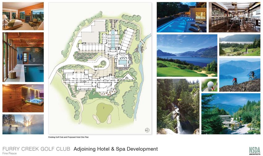
PROJECT TEAM

                                                                           Developer:                  Fine Peace Furry Creek Developments Ltd.
                                                                           Development Manager        Michael Geller & Associates Limited
                                                                           Civil Engineer              CREUS Engineering Ltd.
                                                                           Architect:                  NSDA Architects
                                                                           Landscape Architect:        PWL Partnership Landscape Architects Inc.
                                                                           Environmental:              Cascade Environmental Resource Group Ltd.
                                                                           Geotechnical:               Thurber Engineering Ltd.
                                                                           Survey                      Bennett Land Surveying Ltd.
                                                                           Traffic & Transportation    Bunt & Associates Engineering Ltd.
                                                                           Environmental Marine :     PGL Environmental Consultants
                                                                           Fire Protection:            MJ Blair Consulting Services
                                                                           Hydrogeology:               Western Water Associates Ltd.
                                                                           Flood Control Engineers    Parsons Corporation (formerly Delcan)
                                                                           Electrical:                Primary Engineering and Construction Corp
                                                                           Terrestrial Mapping:       Terra Remote Sensing Inc.
                                                                           Economic Impact/Market     Altus Group Limited
                                                                           analysis

Aerial view looking northwest over golf course and existing developments

                                                                                                                                      3
Fine Peace Furry Creek Developments Ltd
March 18, 2019
Ms. Kimberly Needham,
Director of Planning and Development Services
Squamish Lillooet Regional District
PO Box 219, Pemberton, BC, V0N 2L0
Dear Ms. Needham,
Re: Furry Creek Preliminary Rezoning Application
Fine Peace Furry Creek Developments Ltd, (FPFCD) the new owner of the Furry Creek lands, is pleased to submit this
application for a Comprehensive Development Zoning for the Waterfront and Uplands properties at Furry Creek.
In making this application, we would note that the development potential of these properties was established by
Preliminary Layout Approvals initially granted in 1991 and 1993 by the Ministry of Transportation and Highways. Two
Covenants (The Uplands Covenant and the Oceanside Covenant) that were registered on title in 1993 at the time of
the subdivision of the waterfront lands, set out further obligations with respect to site servicing and the provision of
community amenities. In addition, portions of the property were zoned by the SLRD in 2016. The PLAs and Covenants
provide for up to 920 single and multi-family residential units, a golf course and clubhouse, neighbourhood
commercial space, resort or hotel facilities, a marina, community facilities, and trails and public open spaces. Much of
this is also set out in the Official Community Plan.
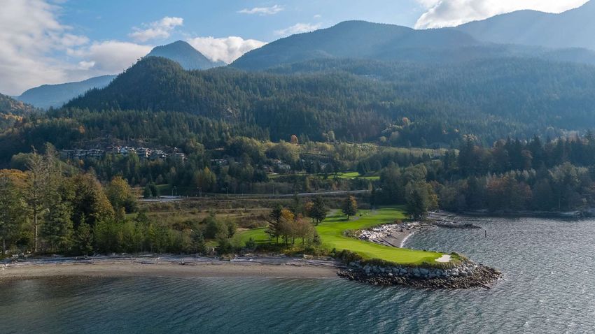
However, we are now seeking a Comprehensive Development Zoning for all the lands to permit greater clarity in the Aerial looking north east over signature 14th hole and Lot 2
vision of housing choices offered within the community, and greater certainty with respect to the design and location
of the neighbourhood commercial village, resort/hotel facilities, marina, and other community amenities. This zoning The Furry Creek Community
will also define new affordable housing requirements and an improved public open space and trail network. comprises approximately 419
hectares (1036 acres) of property to
This application has been prepared by FPFCD and a consultant team which has many decades’ experience in the the north and south of Furry Creek
planning and development of Furry Creek, and other successful new communities. The plans have also benefitted from along the Sea-to-Sky highway. In
ongoing input from Furry Creek residents, many of whom have lived in the community since its founding. 1991, plans were approved for a
complete, recreational/residential
In submitting this application, we would like to thank SLRD staff for your ongoing advice since our first meeting in community. Today, the golf course
2017, and the Furry Creek Community Association for its time and effort, and thoughtful suggestions during the and clubhouse have been
planning process. completed, along with 56
condominium residences along the
It is our hope that a positive and timely approval of this application will allow the realization of the original vision for waterfront within the Oliver’s
Furry Creek, namely a complete recreational-oriented residential community that will contribute significantly to the Landing development. Another 90
amenities and attractiveness of the entire Sea-to-Sky Corridor. single-family lots and 4 duplex
home sites have been completed in
Yours sincerely, the Benchlands area. Since fall
2017, improvements have been
On behalf of Fine Peace Furry Creek Developments Ltd. made to the golf course and
clubhouse, and meetings have
taken place between FPFCD, the By virtue of its magnificent waterfront setting, and high-quality design, the
Oliver’s Landing development has attracted homebuyers from across Metro
Michael Geller Architect AIBC, FCIP, RPP, MLAI new owner and local residents, Vancouver and around the world.
resulting in a renewed optimism in
Development Manager
the community. 4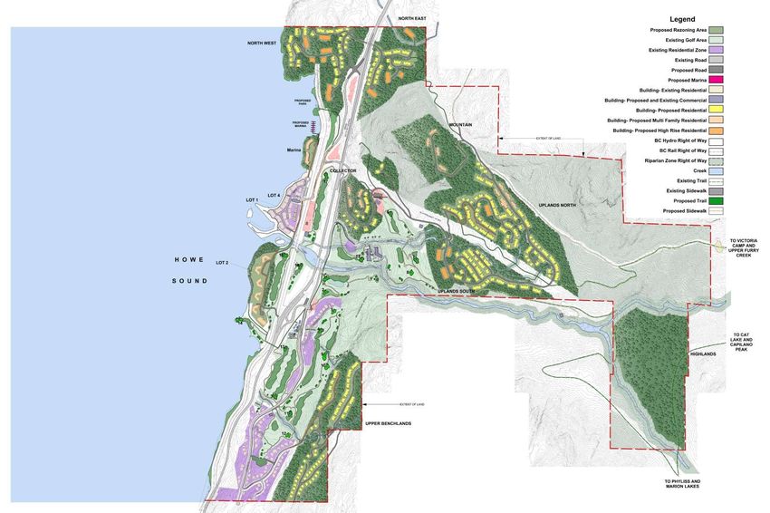
1.0 INTRODUCTION

Planning for the Furry Creek community began in 1990 following the purchase of the property by Tanabe
Corporation of Japan (subsequently renamed Tanac Land Development Corporation). While at one time the
property was considered as a possible location for industrial uses, Tanac’s vision was for a complete,
environmentally sensitive, recreation-oriented residential community. A planning team led by Michael Geller &
Associates was assembled and a broad array of planning and engineering studies were carried out.

Since the lands were located in an unincorporated area, an application was submitted to the Ministry of
Transportation and Highways, and in 1991 Preliminary Layout Approval (PLA) was granted for a complete
community comprising a golf course, up to 920 residential units, a resort or hotel, marina, commercial and
community facilities. In 1992 work proceeded on the golf course and roads serving the first residential
neighbourhoods. However, since the site was somewhat isolated from Metro Vancouver with relatively poor
highway access, especially when compared with today, residential development did not progress as hoped.

After considerable investment in the golf course, clubhouse, site services including a waste water treatment
plant, water system and roads, in 1999 Tanac sold the Waterfront Lands to United Properties which commenced
the multi-phased 250-unit Oliver’s Landing condominium development. Following completion of the first 56
homes, United Properties got into financial difficulty on another project and the balance of their lands were
purchased by The Burrard Group/GolfBC which had previously acquired the golf course. Parklane Homes
subsequently acquired the Uplands, and successfully developed two dozen new homes.

                                                    In 2017 FPFCD, the Canadian subsidiary of an international
                                                    company active in the development of golf course and resort-             Derek Neale of NSDA Architects presents earlier concept plans at a 2-day design workshop with community residents.
                                                    oriented residential communities, purchased the holdings of
                                                    Burrard Group. In 2018, it acquired the Tanac Lands from Parklane
                                                    Homes. FPFCD is determined to realize the original vision of a
                                                    complete recreational/residential community at Furry Creek, with
                                                    a variety of housing choices, neighbourhood village retail space,
                                                    resort facilities, a residents’-only marina, community facilities and
                                                    an extensive open space and trail network.

                                                    This report describes the site’s history, earlier plans and approvals,
                                                    and new planning and engineering studies undertaken over the
                                                    past 18 months. The architectural and planning designs have been
                                                    prepared by NSDA Architects, led by Derek Neale, the original
                                                    architect for Oliver’s Landing. The engineering studies have been
                                                    prepared or managed by Kevin Healy of CREUS Engineering, who
                                                    also has decades of experience at Furry Creek, initially with Tanac
                                                    and subsequently with private consulting engineering firms. Both
                                                    are extremely knowledgeable about the challenges and
                                                    opportunities afforded by this very special property.

                                                    While the proposals set out in this rezoning application may
                                                    appear ambitious, FPFCD and its consultants have a proven track
                                                    record in the planning and development of successful communities.
                                                    Notwithstanding the past financial difficulties at Furry Creek, we
                                                    are confident that given the highway improvements and changing                Originally designed by Brian Hemingway and completed in 1993, the Furry Creek clubhouse is regarded
The first hole at Furry Creek. Over the years the   market conditions, these development proposals are realistic and              to be one of the best contemporary examples of Pacific Northwest architecture in Canada.
course has been reconfigured and improved.
                                                    can be phased over time for the benefit of the SLRD, existing
                                                    community residents, and the entire Sea-to-Sky Corridor.                                                                                                                             5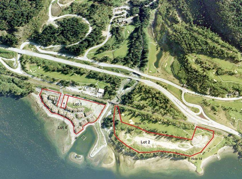
2.0 HISTORICAL OVERVIEW OF FURRY CREEK DEVELOPMENT

1990 Michael Geller & Associates, on behalf of Tanac Land Development Corp.
submits a PLA application for a complete recreational/ residential community
with a golf course, up to 920 residential units, a resort or hotel, marina and
chandlery, community amenities and ancillary services.
1991 The first PLA is issued by Ministry of Transportation and Highways. Tanac
proceeds with planning and development of the golf course, sewage treatment
plant, domestic water and public road system.
1992 Tanac removes a dam on Furry Creek that had been condemned by
Ministry of Environment to protect future residential areas, highway and
railway.
1993 Furry Creek Golf Course and clubhouse opens and first phase of
residential lots offered for sale
1995 Additional lots offered for sale in uplands
1996 Planning for the waterfront lands begins and Tanac seeks developer
partner or purchaser
1997 Completion of Furry Creek interchange including Highway underpass.            As part of the marketing program, a Discovery Centre was built in 1998. The           Some of the initial houses built by Tanac and Parklane. While not the British
Next phase of residential lots offered for sale                                    ‘lighthouse’ design was intended to attract motorists driving along the highway.      Properties, many of the 71 completed homes are very attractive and appealing
1999 Waterfront Lands are subdivided into Lot 1 (Marina Area), Lot 2 (south of
Creek), Lot 3 (to be part of Director’s Lands) and Lot 4 (proposed commercial
area). Waterfront Covenant signed and Lots 1, 2 and 4 sold to United Properties
and golf course to Burrard Group.
2000 United Properties proceeds with first 56 units at Oliver’s Landing
2001 United Properties seeks Court Order Protection due to problems with US
projects. Tanac seeks Court Order Protection. Furry Creek Power applies for a
license for diversion of water
2002 Burrard Group purchases remainder of Waterfront Lands. Furry Creek
Power gets license.
2003 Parklane Homes acquires Tanac and its assets/liabilities
2004-2007 Parklane installs production well P2 and in following years proceeds
with development of homes in Ocean Crest and Stonegate Drive
neighbourhoods. Parklane applies for Water License on behalf of SLRD.
2008-2017 Relatively little activity. Burrard continues to operate golf course
and explores possibility of redeveloping portions of the golf course into new
residential development. Some plans prepared for Lot 2 but no applications
submitted.
2016 SLRD zones the golf course and existing neighbourhoods.
2017 Fine Peace acquires the interests of Burrard Group and begins planning
for completion of Lot 1, and future development on Lots 2 and 4 as well as the
resort hotel adjacent to the clubhouse. Presentations made to community
residents, SLRD staff and Board. Plans also prepared for improvements to the
clubhouse.
2018 Fine Peace organizes a community design workshop and continues with
planning for Lots 1,2 and 4. The first phase clubhouse improvements are
completed. In summer, the company acquires the Uplands from Parklane Homes
and initiates studies to assess development potential and viability of different
neighbourhoods. Further discussions take place with community residents and
SLRD officials. Fine Peace funds improvements to existing trails. Further plans
are prepared (as set out in this application) and presented to the entire
community at a year-end holiday celebration.                                                                                                                                                                                                6
                                                                                              Aerial view of the first 56 townhouses built as Oliver’s Landing. Designed by NSDA Architects, they were developed by United Properties.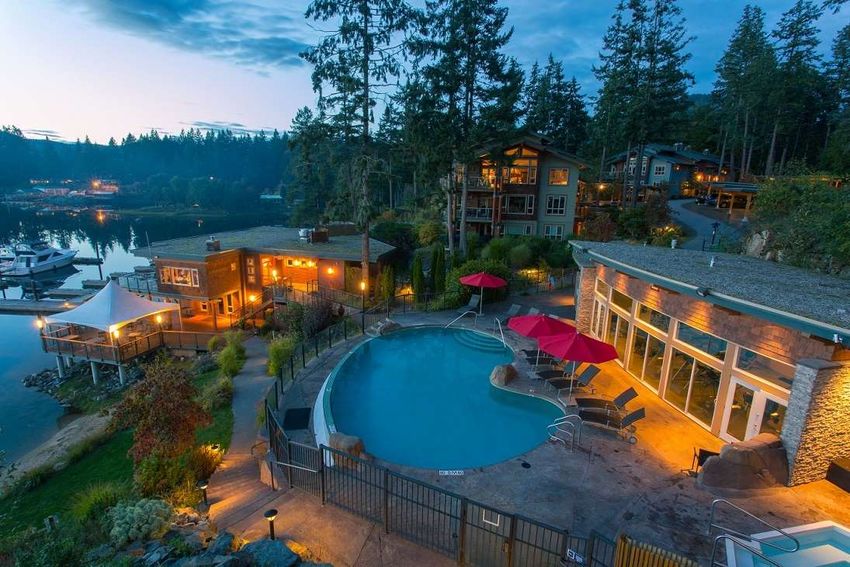
Aerial view of clubhouse with its relocated pro shop and new entry canopy                              View across the water at the first phase of the Oliver’s Landing development on Lot 1

A view looking east at some of the early single-family homes built overlooking the golf course and Howe Sound                                The Clubhouse, with its new covered porte-cochere entry

                                                                                                                                                                                                        7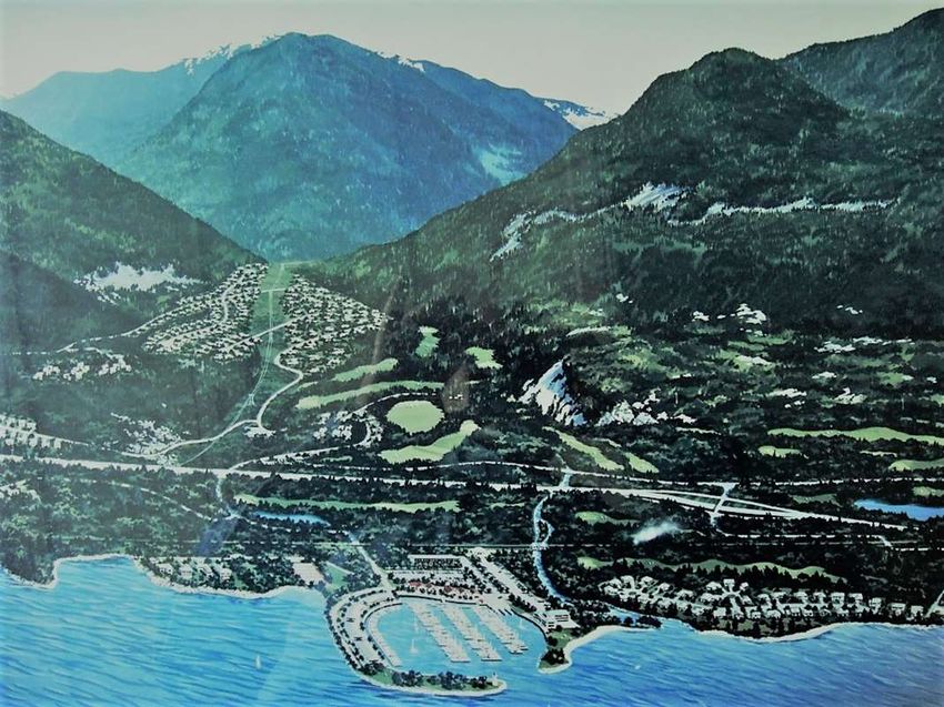
3.0 PROPERTY DESCRIPTION & PREVIOUS                         4.1 Environmental Assessments
USES                                                        Complete biophysical inventory and shoreline habitat
The subject property comprises approximately 419 ha         classification plans have been prepared for the
(1,036 acres) to the north and south of Furry Creek         property. Terrestrial and aquatic ecology studies were
along Howe Sound. Approximately 57 ha (140) acres           carried out to examine biological diversity, impacts on
lie to the west of the highway with 3350 m 11,000 ft.       flora and fauna, habitat size, complexity,
of ocean frontage. The property has had a history           fragmentation or isolation, change to suitability or
related to resource extraction and for many years was       capability, restoration creation or enhancement,
owned by Copper Beach Estates which conducted               related to each component of the development. A
mining activities in the area. While the whole site was     complete inventory was compiled consisting of
logged extensively, logging was concentrated mainly         climate, surface water drainage, water quality,
east of the highway, with a small sawmill and log           vegetation, fish (both fresh water fish and habitats
sorting operation adjacent to Howe Sound. The               and marine/estuarine fish and habitats) and wildlife.
primary use of the property south of Furry Creek was        These assessment and classification plans have
gravel extraction. Over the years, there were               guided the planning and identified recommendations
numerous proposals for this and surrounding                 for environmental mitigation. In many instances,
properties including a petrochemical operation, a           areas of the property are being avoided due to their
pulp and paper mill and a small residential                 unique habitat values and desired setbacks along the
subdivision. However, in 1990 following an extensive        creeks.
site analysis, Tanac Development Canada Corp.
purchased the site for a recreational/residential           Several studies were prepared during the early design
resort community. Plans were prepared by a                  stages of the development. Furry Creek, South Creek       Members of the consulting team have spent considerable time exploring the property
consulting team headed by Michael Geller &                  and Middle Creek were studied in some detail at that
Associates Limited for a golf course, designed by           time. These creeks were deeded to the Crown and
renowned golf course architect Robert Muir Graves,          riparian and flood covenants were established in most
and a marina, resort or hotel, and up to 920                of the areas where the creeks might impact
residential units in single family and multi-family         development zones. North Creek was studied and
form. The plans also included a community centre,           preliminary setbacks were established which have
other community facilities and a variety of public          been incorporated into the planning process. These
open spaces, including parks, trails, and new               will be replaced with the detailed RAR and associated
waterfront access.                                          creek dedications and covenants at the time of
                                                            subdivision.       There are currently marine and
4.0 OPPORTUNITIES AND CONSTRAINTS                           terrestrial environmental studies underway which will
The planning of the property has been influenced by a       be submitted when completed since they are subject
number of significant opportunities and constraints,        to seasonal study. The plans are being continually
including a number of creeks and other environmental        updated based on feedback from the environmental
features, geotechnical and topographical conditions,        consultants.
floodproofing requirements, the impact of B.C. Hydro
rights-of-way, the CN Railway, and highway. While
each of these is described in more detail in this report,
the following is a brief summary of the findings from
the various studies that were carried out prior to the
initial PLA approval and over subsequent years.

                                                                                                                      A complete biophysical inventory and shoreline habitat classification plans have been prepared

                                                                                                                                                                                                                       8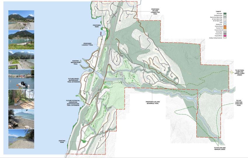
4.2 Geotechnical Assessments                                 4.3 Topography
A 1983 study was undertaken by Thurber Engineering,          The Howe Sound area is defined by a fjord like setting
a firm with considerable experience with this property       and sloping terrain. As established in the Geotechnical
and the Sea-to-Sky Corridor and around Howe Sound            Assessments there are areas of steep slopes, but any
for the Ministry of Transportation and Highways. Titled      areas of concern are generally situated on bedrock and
‘Debris Torrent and Flooding Hazards Highway 99,             the steeper areas are outside of the proposed
Howe Sound” concluded that “Six creeks have been             development zones.       The necessary construction
ranked under low or no risk of debris torrents; these        protocols to develop the lands are consistent with
include Furry Creek and Britannia Creek                      development requirements for hillside developments as
                                                             concluded in those reports.
In 1990 a subsequent Overview Geotechnical
Assessment was carried out by Thurber Engineering,. It       The first phases of development included some of the
focused on how any geotechnical hazards could affect         steeper areas of the site with the majority of Ocean
the development and concluded that the property was          Crest, south end of Furry Creek Drive and Salal Court
one of the most stable areas along Howe Sound. These         situated on lands greater than 40% slope. These are
findings were used to improve the conceptual                 now developed with homes in the Ocean Crest and
development plans. No major landslides risks involving       Furry Creek Drive areas and have proven to be an
soil or bedrock were noted within the proposed               attractive contribution to the community that fits into
development areas. Specific areas where there could          the natural setting of the land.
be a probability of rockfall and debris flows were noted
and avoided.                                                 The development of these lands involved terracing the
                                                             lots and buildings to fit the hillside. Building sites were
Subsequent studies have analyzed geologic process,           carefully created to tie into the topography rather than
terrain stability and safety, and cut and fill analysis. A   being set on a fixed perpendicular roadside lot
separate hazardous conditions study examined mud             geometry. Building design and construction was
flow, debris torrents, erosion, land slip, rock falls,       controlled by a Building Scheme registered on title.
subsidence, and avalanche danger. A subsequent               The design guidelines included direction on how to fit
geotechnical overview was carried out by Thurber             the homes into the hillside and these requirements will
engineering for the entire property. A detailed debris       be carried over to the new neighbourhoods. These
torrent review was prepared for Furry Creek as part of       guidelines are included in Appendix
the waterfront development and concluded the area
was not at risk. Nonetheless, the final foreshore
protection design accommodated a potential debris
flow event.

A more detailed study has been undertaken for the
waterfront lands to address subsidence treatment and
necessary treatments to build on the Furry Creek Fan. .
It is understood that a geotechnical sign off indicating
that the lands are acceptable for their intended use will
be required for each future subdivision. Thurber
Engineering is currently undertaking updated site
reviews and desktop test top studies to bring the
overall preliminary geotechnical assessment up to
current standards. Preliminary feedback has been
incorporated into the current design. The final report is
expected shortly, however no new issues have arisen to
date. The existing reports are assembled in the                                                                            The steeply sloping site offers both challenges and opportunities for new development and recreational amenities
Appendix.

                                                                                                                                                                                                                                 9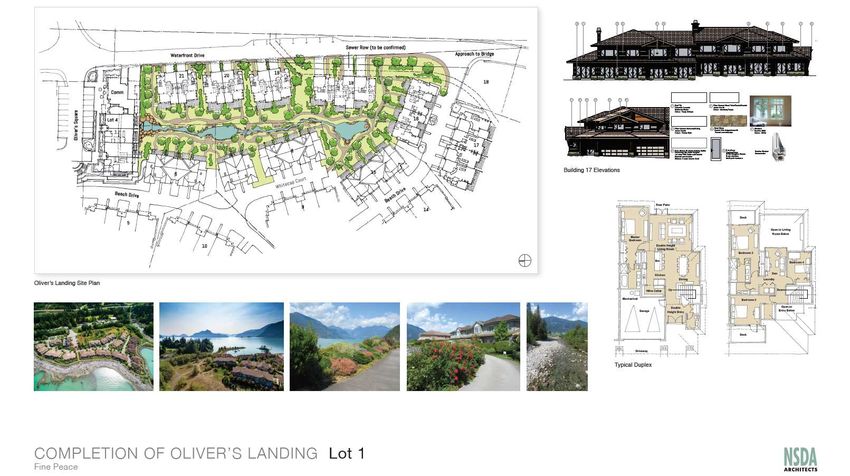
10
 10
4.4 LEGAL

            11
4.5 Archeological assessment
In 1990, as part of the original PLA application, Quirolo As we look to the future, rising sea levels have the
and Ham undertook a comprehensive overview and field potential to have impacts on the Furry Creek community.
reconnaissance of 275 hectares (both coastal and inland) The potential for an increased Flood Construction Level
centred on Furry Creek. As reported in that study and a will be further reviewed and incorporated into the
subsequent 1997 study by Millenia Research “Overview building design for the remaining Oliver’s Landing and
Assessment of the Squamish Forest District” submitted to Waterfront Lot 2 buildings. On the remaining lands, the
the Ministry of Forests and the Archeological Branch of developable land is either significantly above the
the Ministry of Small Business, Tourism and Culture, the foreshore water levels or above relatively deeply incised
Furry Creek study area has been disturbed by Highway creeks such that developable areas are not at risk of
99A (the Sea to Sky Highway), power transmission lines, a flooding and will not require further dyking or flood
quarry site, and shoreline erosion from recreational protection. This will be confirmed for each subdivision.
boating and ferry traffic (Quirolo and Ham 1990: 10).
Quirolo and Ham concluded that the site types expected 4.7 BC Hydro Rights-of-Way
along the coastline include shell middens, lithic scatters, Several B.C.Hydro power line rights-of-way traverse the
and isolated finds. Those steeper areas (between the property. The major right-of-way is a combined wooden
highway and railway) were given a medium potential pole and high tension line with steel box girder towers. A
rating since they border the high potential areas. Lithic second line diverts from the major right-of-way in a
scatters and isolated finds might also be found in the southerly direction. The second right-of-way which
medium potential area but were not recorded by Quirolo extends through the benchlands is capable of
and Ham (1990). The remainder of the study area was undergrounding or relocation and the development plans
given a low potential rating because, despite an extensive assume that one or the other will occur. Discussions are Several B.C.Hydro power line rights-of-way traverse the property.
shovel testing program and the inspection of exposures, currently underway with B.C.Hydro as to their preferred
no sites were found. Nevertheless, the presence of a approach.
previously recorded pictograph site and recorded
Squamish place names suggest that the area was 4.8 CN Railway
extensively used by the Squamish. The direction given at The existing rail ROW was dedicated in the early 1950s.
the time was to not direct additional attention to the CN rail currently operates two trains a day. The railway
pictograph and historical mooring rings in the area were has a signalized crossing that was installed as part of the
cut away. Olivers Landing development. There is a second crossing
south of Furry Creek in the vicinity of the 15th tees boxes.
4.6 Floodproofing This is fenced off but still used by pedestrians accessing
The possible inundation of the site from not only Furry from the highway. The emergency access from the future
Creek but also Howe Sound was assessed when the initial waterfront development on Lot 2 will use this crossing. It
approvals were sought. A number of flood protection is hoped that further development of the pedestrian trail
measures were identified. They include designated system will reduce the reliance on this crossing.
setbacks from the top of bank for both creeks and the
shoreline combined with dyking and established Flood Since BC Rail owned the ROW at the time of PLA, it was
Construction Levels for the habitable dwellings. The one of the key referral agencies at that time. It provided
design for the Furry Creek flood protection was approved a letter indicating general support for the development
by the Ministry of Environment. The first phase was built including a restriction on buildings immediately above the
by United Properties and turned over to SLRD. The tunnel in the NW neighbourhood. There is a desire to
Waterfront Phase was built by Burrard Group and work with the community and the SLRD on establishing a
approved by MOE. There remains some work along the whistle cessation policy with CN on the crossing.
fairway 15 overflow flood route that will be carried out
per the approved design.
The existing rail ROW was dedicated in the early 1950s and CN rail currently operates two trains a day.
124.9 Access, public & private roads
Public Roads: Access to the Furry Creek community is trail, flood protection berm, and trails along the berm
provided from the Sea-to-Sky highway by a split-grade both north and south of the creek. There will also be a
interchange which was sized to accommodate the golf need for an emergency access from Lot 2 to provide
course and clubhouse, approximately 920 housing units, egress for residents in the event of a Furry Creek bridge
up to a 300 room resort hotel (as set out in the PLA washout .
application), an 80-berth marina and ancillary facilities.
Golf Course: It should be noted that the golf course is
Since the community is within the SLRD, public roads are responsible for operating and maintaining certain
owned and maintained by MOTI. The roads constructed infrastructure both within the golf course and where it
within the first 3 phases are all public roads. These crosses into other lands. This includes the permitted golf
include Furry Creek Drive (parallel to and east of the cart underpasses beneath the highway and railway, and
highway), Country Club Road accessing the clubhouse, the cart paths within the MOTI ROW. As part of the initial
and Stonegate Drive at the east end of the Benchlands. subdivision MOTI also required dedication of an unopened
Sea View Drive was dedicated as a public road from Furry road ROW adjacent to the signature 14th Hole to ensure
Creek Drive to the reservoir location. Howe Sound Drive public access to the waterfront. This dedication is
provides southbound access off the highway and turns approximately 0.79 ha or 1.9 ac. It is proposed that this
into Waterfront Drive where it crosses the rail line to be used as a park amenity as set out in an earlier SLRD
access Oliver’s Landing. letter of support dated September 5, 2006. MOTI
indicated it would support this use while the land remains
Based on discussions to date with MOTI, the expectation dedicated as unopened road. A public parking area was
is that future roads will be designed and publicly created on the public portion of Beach drive that is
dedicated where they serve multiple strata communities parallel to the rail.
or provide access to lands beyond. Given the topography,
the road accessing the reservoir was designed and Assessment by Bunt Associates: Bunt Associates was In 1997, the Furry Creek interchange was completed providing improved access to the community from north and south
approved at a 12% grade. It is anticipated that further retained to evaluate the existing and planned road system
variances will be required based on the road alignments in terms of accommodating the traffic that will result
designed to date. from the various uses now being proposed, including up
to 120 units of additional affordable housing. Their report
Private or Strata-owned Roads. Roads serving is included in the appendices and concludes as follows:
individual neighbourhoods will likely be designed as strata
roads, as was the case for Oliver’s Landing. Beach Drive is “With the anticipated future total traffic volumes, all
a strata road as is Ocean Crest Drive to the east of Furry movements at all intersections within the study area are
Creek Drive at the entrance. All future strata roads will anticipated to operate at LOS B or better, and the
comply with TAC and SLRD guidelines for road design. Highway 99 on and off ramps will operate at LOS C or
These will include new roads on Lots 1 and 2. Waterfront better. Accordingly, our analysis indicated no need for
Drive may be a publicly dedicated road. However, if it and laning or traffic control modifications to the exiting
the new Furry Creek Bridge are privately owned, there intersections and ramps.” To better accommodate
will be a Statutory ROW in favour of the SLRD to provide alternate modes of transportation, Bunt recommends
public access over the road and bridge to access the planning for bus pullouts along Highway 99 and within
seawall the local road network”. This has been considered in the
new site planning.
. Roads serving individual neighbourhoods will likely be designed as strata roads, as was the case for Oliver’s Landing
134.10 Rights-of-Way
Planning for the site has been influenced by a number of rights-of-way
owned by MOTI, BC Hydro, and CN Rail, as well as dedicated roads,
future dedicated roads, existing and future covenant areas.
144.11 Water System
An independent water system including groundwater and Fine Peace is currently investigating other groundwater
surface water sources, pump stations, reservoirs and a options and expects to have a second production well
treatment facility has been built to service the first rated by this summer.
residential neighbourhoods and golf club to meet both
domestic and fire protection needs, as per Fire 4.12 Waste Water Treatment Plant
Underwriters requirements. This water infrastructure is and Sanitary Sewers
owned by the SLRD. The SLRD funds the operation under With the proposed density of development, the rocky
a Local Area Bylaw which is detailed as Furry Creek nature of the site, and a desire for an environmentally
Water Rates and Regulations Bylaw No. 1431-2016. The responsible and sensitive development, a self-contained
current water supply is from a well on Lot 8 within the Waste Water Treatment Plant (WWTP) was installed by
first phase subdivision to the east of Furry Creek Drive the developer and handed over to the SLRD. It operates
and south of Furry Creek. The system will be expanded as under a permit included in the Appendix. It has been
required by the various regulatory agencies prior to designed to expand as the community grows to
approval of each subdivision to meet neighbourhood accommodate the proposed number of housing units, the
requirements. The existing well is adequate for the clubhouse and resort or hotel facilities. A piped sanitary
existing homes plus another 60 units, at which time a sewage collection system has been constructed to serve
backup system will be required. the first neighbourhoods. It drains by gravity wherever
possible to the central treatment plant. Pump stations
Western Water Associates and Thurber Engineering are have, and will be constructed where necessary. The
currently studying the aquifer to determine the location current plant is sized to accommodate up to 520
for a future well that should provide the volumes residential units and the golf course. The Lot provided
necessary to serve another 200 units and the required for the sewage treatment facility is sized to
level of redundancy. An abandoned Irrigation well will accommodate a future expansion to accommodate the
also be upgraded to act as a back up well, as per the full development. Furry Creek, the largest of the various creeks within the site has the largest watershed on Howe Sound.
original intention.
Furry Creek, the largest of the various creeks within the
site has the largest watershed on Howe Sound. It is the
current licensed source for golf course irrigation water.
There is an additional water license 122587 File
2002892 on Furry Creek in the name of the SLRD for
domestic water. It allows for 195,182,012 gallons a year
at a rate of not more than 893 gpm. This is adequate for
full build out. The intake is in place. The required
treatment rate will be determined later in the
development depending on the available groundwater
sources. Associated Engineering has prepared a concept
design for a treatment plant to be placed on Lot 8 This
surface source could provide all the water needs for the
community; however further groundwater sources will be
investigated as the project develops.
A Golf course irrigation well was constructed on the far
side of the Creek known as I1, and rated at 225 USGPM.
The intent at the time of the initial subdivision was that
the Irrigation well could be converted into a backup or
dual production well for domestic water. The Golf Course
irrigation is now sourced via a surface Water License A self-contained waste water treatment plant was installed by the developer and handed over to the SLRD.
#104289, off of Furry Creek held by the golf course.
154.13 Stormwater Management
The current stormwater management objectives are to water for interface needs if required. The department is
maintain stormwater flow from the lands at pre- also trained to draft from any surface water sources,
development levels and store volumes with a low flow including the ocean, if necessary.
release system and encourage infiltration such that the
flow leaving development sites is similar to Under the terms of the Upland Covenant, the developer
predevelopment conditions and maintains normalized is obligated to provide a site and contribute to the
flow into the creeks and drainage courses. This has been funding of a future Fire Hall. The developer is also
accomplished by a combination of rain gardens, some prepared to contribute to the funding of new equipment,
underground piping, surface bioswales, infiltration and training and support to provide fire fighting services
fields, ponds and structural storage. There has also been for taller buildings, as proposed within the community.
enhancement work on both South Creek and Middle
Creek. The golf course has incorporated stormwater Furry Creek has a sprinkler bylaw 879 – 2003 mandating
management features, including ponds, to mimic fire sprinklers in all buildings including all existing
predevelopment flow and drainage. buildings on site. Existing fire safety reports and bylaws
are included in the appendix.
There is a permitted stormwater outlet into the marina
to serve the north side of Furry Creek and a 900 mm As part of this application, a third-party expert report is
outlet into Howe Sound adjacent to the 14th Hole tee being prepared by Jack Blair and Doug Dymond who
box. Within the uplands area there were initial concerns previously prepared a fire safety report for the SLRD in
brought forward by DFO regarding discharge of 2013. Their preliminary findings indicate that a Mutual
stormwater into Middle Creek. However this creek has Aid Agreement with the District of Squamish will likely
now been enhanced such that it is fish bearing. It is be feasible for a call to Furry Creek specifically to
therefore beneficial to maintain the stormwater feeding address a fire in a taller building. Both the CAO and Fire A new lake adjacent to the golf course’s 1st hole serves as part of the community’s stormwater management system
the Middle Creek system. It was agreed with DFO at the Chief of Lions Bay have also indicated support in
time to provide bio treatment wetlands within the principle for a Mutual Aid Agreement with the SLRD and
Hydro right-of-way to treat the stormwater prior to Britannia Beach FD.
discharging back to Middle Creek. This will reduce the
reliance on piping, maintain flow in Middle Creek and Discussions have also taken place with the Sicamous Fire
enhance the community use of the hydro right of way by department as to their operating guidelines for tall
providing ground cover planting and trails in the area. building response as they have a 7 storey building and
are a very small department with just 1 paid member.
The Sechelt FD is quite a small department and it has a 6
4.14 Fire protection
storey building within its jurisdiction. The Parksville FD
Furry Creek is served by the Britannia Beach VFD. Under
has to deal with a 10 storey concrete building and the
the direction of Fire Chief David Rittberg, it provides
Big White Fire Department has a 9 storey older building
structural fire suppression, vehicle fire response and
within its jurisdiction. Discussions will also take place
interface fire assistance to Furry Creek under the
with Harrison Hot Springs and other volunteer fire
authority of SLRD Establishing Bylaw 1032-2006. This
departments that must attend to taller buildings.
service covers Britannia Beach, Furry Creek and the non
wildfire interface portions of Porteau Cove. There are
A number of additional fire safety design features will be
currently discussions underway with Lions Bay and
set out in the report and will be considered to help
District of Squamish to provide Mutual Aid in the event
address possible fires in taller buildings. They include
of emergency need.
video cameras on each floor and intercoms on every 2
floors. In this way, when the FD arrives at the
The existing SLRD owned water system is designed to
annunciator panel they can see video of the floor in
meet FUS requirements for pressure, flow, volume,
question and begin a size up and Incident Action Plan
hydrant spacing and emergency service vehicle access.
without going up to the floor. This could work very well
New phases of the community will continue to meet
at Furry Creek as the FD could implement some actions Members of the Britannia Beach Volunteer Fire Department pose for this 2012 photo.
these requirements. The Britannia volunteer FD is
while awaiting Squamish FD and Lions Bay FD.
however trained and equipped to pump and shuttle
164.15 Other Utilities and Services 4.14 Community amenities
There is a BC Hydro Substation to the west of the The Furry Creek community offers both private and
highway north of the underpass which services the public community amenities. The Golf Course and
property. The initial commitment and work to date has Clubhouse are a major private amenity enjoyed by the
included underground servicing to all lots. This will be community. There are public trails along the seawall
continued for the remainder of the community within Oliver’s Landing and these will extend into the
development. future development south of the creek and elsewhere
through the community. This is discussed in greater
A series of Utility lots was created for ancillary
detail in Section 12. There is a small public parking area
services. They included lots 1, 2,3 of DL1296 Grp 1,
to the north-east of the entrance to Oliver’s Landing.
NWD Plan LMP 16073. These are the lands
This public parking is provided on a MOTI ROW for
immediately east of the railway right-of-way, north of
visitors to the waterfront, and not for Oliver’s Landing
Furry Creek and west of Hole 15 between the public
visitors as many assume. There is an existing lot
road and the golf course. They have panhandles to
designated as future park in the Stonegate
public road accessing Lots 1 and 2 of the Oceanside
neighbourhood and a community lot was identified for
Lands along with reciprocal access and easement
lot 9 in the first subdivision.
agreements. They provide access to the golf course
maintenance building and facilities, WWTP, Telus The Furry Creek Community Association (FCCA)
facility and propane tanks represents the interests of all the residents. It has been
Telus has a fibre switch on Lot 2. The initial
able to obtain funding for trail works such as the Photos to come
Stonegate Community Trail and the trail connecting to
commitment and work to date has included
Furry Creek from an underpass trail under the highway.
underground servicing to all lots. This will be continued . There are public trails along the seawall within Oliver’s Landing and these will extend into the future development
It plays an active role in fostering a sense of community
for the remainder of the community development.
within Furry Creek.
A propane tank farm has been constructed on Lot 3 to
The Oliver's Landing Boat & Kayak Club has a license to
the east of the railway adjacent to the waste water
use the adjacent water lot.
treatment plant. There is an agreement in place with
the Oliver’s Landing strata regarding operation of the Health care services for residents are provided by the
plant Squamish hospital and ambulance services located
approximately 23 km away. Lions Bay has an
Solid Waste collection is managed by the SLRD under
ambulance service 16 km away.
Bylaw #530. A recycling station has been established
adjacent to the Hydro Substation. School facilities for children living in Furry Creek are
available in both Squamish and Lions Bay.
Streetlighting is not required by MOTI as part of public
roads. However, in future, intersections may warrant
illumination. MOTI prefers to leave the lighting as a
community amenity and only manages the highway
cobra lighting. SLRD manages public lighting elsewhere
through a local service area bylaw BL657. The areas
within the strata development are maintained by the
strata.
Canada Post delivers mail via a series of Super boxes.
The Oliver's Landing Boat & Kayak Club has a license to use the adjacent water lot.175.0 CURRENT DEVELOPMENT RIGHTS
5.1 ZONING
Rush House
Property
The Furry Creek zones are set out in Sections 10 dwelling units per ha. The maximum height is
and 11 of the Electoral Area D Zoning Bylaw No. 12m except that within 20 m of the high water
1350-2016 Adopted August 24, 2016. Presently mark of Howe Sound or Furry Creek it is reduced
there are 5 different zones applicable to the to 9 m. The FCR3 zone applies to some existing
Furry Creek Lands. Other portions of the site are single family subdivision and sets minimum
unzoned. FCR1 applies to the existing Oliver’s parcel size and maximum house sizes. FCC1
Landing development and permits a maximum applies only to Lot 4. It allows for a Floor Space
height of 12 m. There are also setback controls Ratio of 3.0 and a maximum height of 15 m. The
and a maximum density of 32 dwelling units per intent of the FCC2 zone is to accommodate the
ha. Lot 2 which is south of the Creek is zoned Furry Creek golf course development within the
FCR2. It also has a maximum density of 32 zone boundaries. 185.2 CURRENT DEVELOPMENT RIGHTS: PRELIMINARY LAYOUT APPROVALS
There have been a number of PLAs issued for the of the Waterfront Lands subdivision at some time
property. The first was dated April 30, 1991 and a between 1998 and 2000. However the documents
subsequent approval was dated April 30, 1993. all set out the scope of the development as
There may have been a third update at the time follows:
The development will include a golf course, marina, resort or hotel, and up to 920
residential units in single-family and multi-family form. The development will also
include ancillary facilities and a variety of public open spaces, including parks, trails and
new waterfront accesses as basically proposed in the report dated December 1990.
It should be noted that in the initial submission two was proposed that there be a maximum of three
sites were identified for the resort and hotel. The hundred rooms on the site, along with tennis
first was a 9-acre area located adjacent to the courts, restaurants, and a swimming pool. The
marine between the railway right-of-way and exact size of the marina was not determined either,
Howe Sound. The second was a site at the top of but in the report it stated it would not be less than
the existing knoll, east of the Highway. In total, it 80 berths and include a chandlery shop and store.
Rush House Property
195.2 Site Plans accompanying early Preliminary Layout Approvals
These are just two of the plans that accompanied the early Preliminary Layout Approval (PLA) applications. A number improved neighbourhood village retail area and community ‘heart’ and the resort facilities. These plans also further
of significant improvements have been made, both within the Waterfront Lands and the Uplands. Further enhance the trails and public open space system.
improvements are now being proposed to reflect the need for broader housing choices, to accommodate an
205.3 CURRENT DEVELOPMENT RIGHTS: COVENANTS: WATERFRONT (OCEANSIDE) AND UPLANDS Rights and Obligations from the 219 Covenants to be
incorporated into the new Comprehensive
Development Zoning Bylaw
In the absence of zoning, in addition to the provisions as set out
in the PLAs, two 219 Covenants were signed by Tanac
Development Canada Corp. and the Squamish Lillooet Regional
District and registered on title to guide the scope and phasing of
development on the Waterfront (or Oceanside) and Uplands. In
2006, certain definitions and terms in the Uplands Covenant
were modified by the parties.
The Waterfront covenant provides for 250 units; approximately
80 units in what is referred to as the Marina neighbourhood
where Oliver’s Landing has been developed, and approximately
170 units on Lot 2. The Covenant also references a gross floor
area of 15,000 square feet of commercial space. As previously
noted, this Covenant was subsequently augmented by the FCR1,
FCR2 and FCC1 zoning for the lands.
The Uplands Covenant permits 670 residential units on the
lands. In addition, it sets out the owners obligation with respect
to the provision of a number of community amenities and
ancillary facilities. These include a Fire Hall, a 4,000 sq.ft.
Community Centre, 1000 sq.ft. of Administrative offices and a
Public Works Yard to serve a community of 920 residential units
having a minimum area of 1.0 acre of flat useable serviced land.
However, although the land upon which the first 71 units, has
been zoned, no zoning has been put in place for the balance of
Excerpt from the Waterfront Covenant the uplands.
As discussed with SLRD staff, it is proposed that the rights and
obligations as set out in these Covenants be incorporated into the
new Comprehensive Development Zoning Bylaw along with
clarification as to maximum permitted building heights in each
neighbourhood, and development controls related to the resort
hotel, marina and the proposed relocated commercial area, using
as a template the Porteau Cove Comprehensive Development 1
Zoning Bylaw.
Excerpt from the Uplands Covenant It is proposed that Design Guidelines, similar to those prepared
for Porteau Cove form part of the new zoning bylaw.
To ensure clarity, once the Zoning Bylaw for Furry Creek has been
given final approval, along with the associated agreements, the
existing 219 Covenants can be discharged and future
development on the lands will be regulated like any other zoned
lands in the District.
215.4 CURRENT DEVELOPMENT RIGHTS: OFFICIAL COMMUNITY PLAN (OCP)
The following is an excerpt from the Official Community Plan: “A
development agreement with the Squamish-Lillooet Regional 4.3 AFFORDABLE HOUSING
District (SLRD) is in place and Furry Creek has an approved It is recognized that a diversity of housing forms and options
Preliminary Layout Approval (PLA) with the Ministry of contributes to a diverse and vibrant community. In many cases,
Transportation and Infrastructure for development of 920 higher density developments that are suited to incorporate
residential units consisting of up to 250 units in the “waterfront” affordable housing, as a component of the development are
lands and up to 670 single family lots in the “uplands”. directed towards urban areas due to the availability of services
Development is about 15% complete.” The following are such as sewer, water and public transportation. In those cases
additional references to the community found in the plan where high density
Developments are being considered in the plan area, steps
3.5 SERVICES AND INFRASTRUCTURE (COMMUNITY
should be taken to ensure that a diversity of housing is offered,
SERVICES)
including a variety of housing types, sizes and tenures.
Community Services in the plan area include:
Furry Creek Water
5.16 Planned Community Designation
Currently the community water system at Furry Creek has a
The Planned Community designation applies to those lands that
capacity of roughly 270 units, and there are 152 active
have undergone, or will undergo a more focused planning
connections.
process and ultimately the development of a sub-area plan.
SOLID WASTE MANAGEMENT
Planned communities are serviced nodes of development that
The SLRD provides Solid Waste Management services that are
may be primarily residential, or can include a mix of uses such
guided by the Solid Waste Management Plan. Garbage and
as residential, commercial to service the local needs, and create
recycling is done by curbside pick-up in Furry Creek and
a more complete community.
Britannia Beach, and there is a transfer station at Furry Creek.
Objectives
5.16.1 To denote those areas that have undergone focused
4.1.2 Industrial Development
planning exercises which resulted in the creation of sub-area
There are very few industrial uses, beyond resource industrial,
plans.
occurring in the plan area. There is a small industrial zone at
5.16.2 To denote areas that have undergone development, and
Furry Creek that was established to accommodate an
which will undergo focused planning processes in the future. 6.3 Development Approval Information Area The Development Approval Information Bylaw will
Independent Power Project, however, as a result of changes at
Policies also specify the matters for which additional on-site and off-site information will be required
the Provincial level, Independent Power Projects no longer
5.16.3 Uses permitted in the Planned Community designation including but not limited to:
require Local Government zoning.
shall be determined as part of the more focused planning
process, and will be elaborated in the sub-area plans, but will Determination of the location and extent of sensitive ecosystems;
4.2 COMMERCIAL DEVELOPMENT
generally include residential, mixed use, commercial, ‘non- Transportation study, including traffic patterns and flows;
The District of Squamish and Resort Municipality of Whistler are Parking study;
polluting’ industrial, institutional and parks and open spaces;
the primary commercial centres servicing Electoral Area D Infrastructure analysis, including evaluation of local infrastructure capacity;
5.16.4 The neighbourhood of Furry Creek should consider
residents. Within Britannia Beach, Porteau Cove and Furry Public facilities evaluation, including inventory of facilities such as schools and parks, and future
undergoing a process to develop appropriate zoning.
Creek, there are several lands designated for commercial uses. demand estimates;
These designations include tourist commercial and tourist Archaeological assessment or impact study;
accommodation, as well as commercial and community Acoustic impact assessment;
commercial uses and should be further elaborated in the Determination of the location of areas of geotechnical concern
policies of the Howe Sound East Sub Area Plan. Demonstration that proposed sewage and water servicing, whether they are proposed to be on-site
or community systems, meet the requirements of the applicable government agency;
To support sufficient commercial development within Planned Consideration is given to wildfire interface hazards in the planning of residential clusters;
Demonstration of the need for additional residential parcels;
Communities to meet the day to day needs of residents of those
Market Analysis;
communities. Permitted uses on Commercial lands will be Sustainability information.
determined on a site specific basis, but could include
restaurants, retail stores, tourist accommodation and lodging,
offices, clinics, and other personal service businesses to serve
local needs.
226.0 COMMUNITY DESIGN WORKSHOP
In January 2018, FPFCD organized a Community Design Workshop. 130 Oliver’s Landing and Uplands residents participated over two days..
The purpose of the workshop was to obtain
community feedback on preliminary concept plans
for the completion of Lot 1, and residential
development on Lot 2 and a mixed-use
development on Lot 4. Concept plans for the
proposed resort hotel and marina were also
presented. At the time of the workshop, Fine Peace
had only acquired the Waterfront Lands and the
Golf Course.
The workshop was structured over two days. On
Friday afternoon, participants were provided with
an overview of the history of Furry Creek. Kim
Needham gave a presentation on the Official
Community Plan and an update on other major
projects along the Sea-to-Sky Corridor.
Unfortunately, a representative of BC Transit was
unable to attend. However, BC Transit provided an
update on the proposed transit improvements
along the corridor.
This was followed by a presentation by Derek Neale
on new housing, commercial area(s), resort hotel
and possible marina expansion, public space
network and other proposed amenities. Derek was
followed by Kevin Healy of Creus Engineering who
provided an overview of the various technical
issues impacting development. These included
sewer and water capacity, environmental
considerations, floodproofing requirements, and
geotechnical considerations.
The next morning, the residents were organized
into different groups to discuss eight different
topics: Housing choices, need for and type of
commercial spaces, resort hotel, marina facilities
public space network, golf course improvements,
other amenities, transportation improvements, and
other topics suggested by attendees.
Interestingly the two best attended workshops
were on the public space and trail network and
transportation.
Overall, the sessions were extremely valuable for
Fine Peace and the design team. The following At the workshop, large maps were presented to help residents understand the relationship between the different parcels. Inset: Derek Neale of NSDA Architects reviews plans for the completion of
Lot 1, development of Lot 2 and 4 with local residents. The concept plans for the resort and open space network were also shared with the community.
pages include extracts from the presentation
materials and community response. 236.1 LOT 1 PLANS PRESENTED AT COMMUNITY DESIGN WORKSHOP
The plans proposed a reduced number of townhouses on Lot 1 in order to provide a more attractive appearance and improved views along Waterfront Drive which
also serves Lot 2. Some concerns were expressed about safety aspects of the proposed water features, which have now been eliminated in the revised plans.
246.2 LOT 4 PLANS PRESENTED AT COMMUNITY DESIGN WORKSHOP
The plans, based on the current zoning, included a General Store and café along with new live- Concerns were expressed regarding the somewhat boxy appearance of the building, which did
work units at grade. Three levels of residential were proposed above. All parking is not seem to fit in with the adjacent townhouse designs, and potential disturbance for adjacent
underground. This was the first time most residents had seen any plans for this property. residents from commercial traffic, and overlooking from upper floor suites.
25You can also read