DRAFT BASIC ASSESSMENT REPORT - SAHRIS
←
→
Page content transcription
If your browser does not render page correctly, please read the page content below
DRAFT BASIC
ASSESSMENT REPORT
                               FOR

PROPOSED HOSPITAL EXTENSION - DIE WILGERS EXT 83

                   REF: GAUT 002/18-19/E2268

                         PREPARED FOR:
          Plan Associates Town and Regional Planners Inc.
                          339 Hilda Street
                          Hilda chambers
                              Hatfield

                        Tel: 012 342 8701
                        Fax: 012 342 8714

                          COMPILED BY:
                  Lokisa Environmental Consulting
                           P.O. Box 219
                            Groenkloof
                               0027

                        Tel: 012 346 7655
                        Fax: 012 346 6074

                         September 2018

                       Enq: Delia de Lange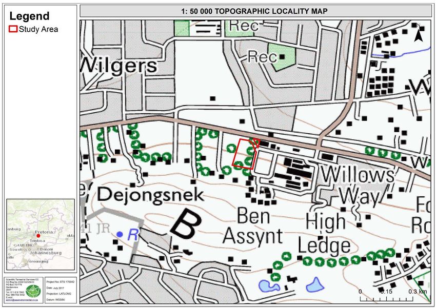
CONTENTS
CONTENTS .................................................................................................................................................... I
LIST OF FIGURES .......................................................................................................................................... III
LIST OF TABLES ............................................................................................................................................ III
APPENDICES ............................................................................................................................................... IV
DEFINITIONS ............................................................................................................................................... V
ABBREVIATIONS ....................................................................................................................................... VIII
    SECTION A: ACTIVITY INFORMATION ............................................................................................................. 3
      1.    PROPOSAL OR DEVELOPMENT DESCRIPTION .................................................................................. 3
      2.    APPLICABLE LEGISLATION, POLICIES AND/OR GUIDELINES ............................................................. 3
      3.    ALTERNATIVES ............................................................................................................................... 15
      4.    PHYSICAL SIZE OF THE ACTIVITY .................................................................................................... 17
      5.    SITE ACCESS ................................................................................................................................... 17
      6.    LAYOUT OR ROUTE PLAN ............................................................................................................... 18
      7.    SITE PHOTOGRAPHS ...................................................................................................................... 18
      8.    FACILITY ILLUSTRATION ................................................................................................................. 18
    SECTION B: DESCRIPTION OF RECEIVING ENVIRONMENT ............................................................................ 20
      1.    PROPERTY DESCRIPTION................................................................................................................ 20
      2.    ACTIVITY POSITION ........................................................................................................................ 20
      3.    GRADIENT OF THE SITE .................................................................................................................. 21
      4.    LOCATION IN LANDSCAPE .............................................................................................................. 21
      5.    GROUNDWATER, SOIL AND GEOLOGICAL STABILITY OF THE SITE ................................................ 21
      6.    AGRICULTURE ................................................................................................................................ 21
      7.    GROUNDCOVER ............................................................................................................................. 22
      8.    LAND USE CHARACTER OF SURROUNDING AREA .......................................................................... 23
      9.    SOCIO-ECONOMIC CONTEXT ......................................................................................................... 24
      10. CULTURAL/HISTORICAL FEATURES ................................................................................................ 27
    SECTION C: PUBLIC PARTICIPATION (SECTION 41) .......................................................................................... 30
      1.    The Environmental Assessment Practitioner must conduct public participation process in
      accordance with the requirement of the EIA Regulations, 2014. ............................................................ 30
      2.    LOCAL AUTHORITY PARTICIPATION ............................................................................................... 30
      3.    CONSULTATION WITH OTHER STAKEHOLDERS ............................................................................. 30
      4.    GENERAL PUBLIC PARTICIPATION REQUIREMENTS....................................................................... 31
      5.    APPENDICES FOR PUBLIC PARTICIPATION ..................................................................................... 31
    SECTION D: RESOURCE USE AND PROCESS DETAILS ..................................................................................... 32
      1.    WASTE, EFFLUENT, AND EMISSION MANAGEMENT ..................................................................... 32
      2.    WATER USE .................................................................................................................................... 33
      3.    POWER SUPPLY.............................................................................................................................. 33
      4.    ENERGY EFFICIENCY ....................................................................................................................... 34
    SECTION E: IMPACT ASSESSMENT ................................................................................................................ 35
      1.    ISSUES RAISED BY INTERESTED AND AFFECTED PARTIES .............................................................. 35
      2.    IMPACTS THAT MAY RESULT FROM THE CONSTRUCTION AND OPERATIONAL PHASE ................. 36
      3.    IMPACTS THAT MAY RESULT FROM THE DECOMMISSIONING AND CLOSURE PHASE .................. 48
      4.    CUMULATIVE IMPACTS .................................................................................................................. 49
      5.    ENVIRONMENTAL IMPACT STATEMENT ........................................................................................ 49
      6.    IMPACT SUMMARY OF THE PROPOSAL OR PREFERRED ALTERNATIVE ......................................... 51
      7.    SPATIAL DEVELOPMENT TOOLS..................................................................................................... 52
      8.    RECOMMENDATION OF THE PRACTITIONER ................................................................................. 52
      9.    THE NEEDS AND DESIREBILITY OF THE PROPOSED DEVELOPMENT (as per notice 792 of 2012, or
      the updated version of this guideline)..................................................................................................... 53

DRAFT BASIC ASSESSMENT REPORT                                                                                                                       i
PROPOSED HOSPITAL EXTENSION - DIE WILGERS EXT 83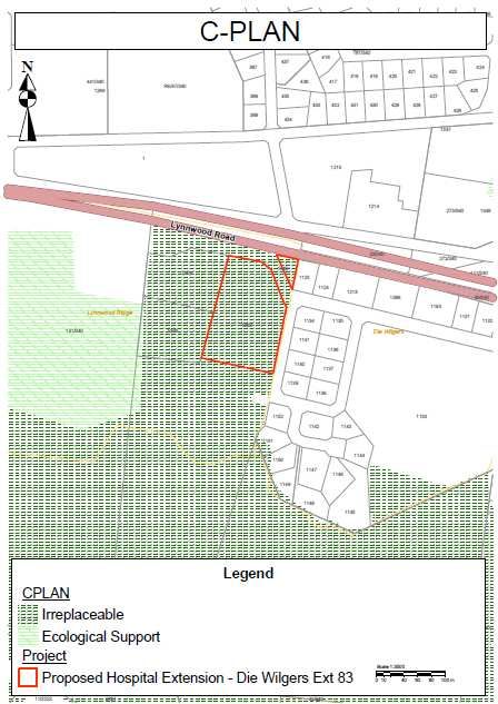
10. THE PERIOD FOR WHICH THE ENVIRONMENTAL AUTHORISATION IS REQUIRED (consider when
    the activity is expected to be concluded) ................................................................................................ 53
    11. EVIRONMENTAL MANAGEMENT PROGRAMME (EMPr) (must include post construction
    monitoring requirements and when these will be concluded.) ............................................................... 54
  SECTION F: APPENDIXES............................................................................................................................... 55

DRAFT BASIC ASSESSMENT REPORT                                                                                                                 ii
PROPOSED HOSPITAL EXTENSION - DIE WILGERS EXT 83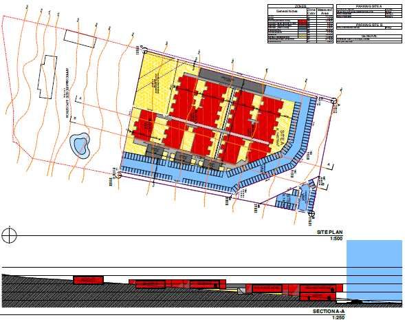
LIST OF FIGURES
FIGURE 1: C-PLAN ................................................................................................................................................... 9
FIGURE 2: GPEMF ................................................................................................................................................ 11
FIGURE 3: LOCALITY OF THE PROPOSED PROJECT .......................................................................................................... 16
FIGURE 4: SITE PLAN.............................................................................................................................................. 16
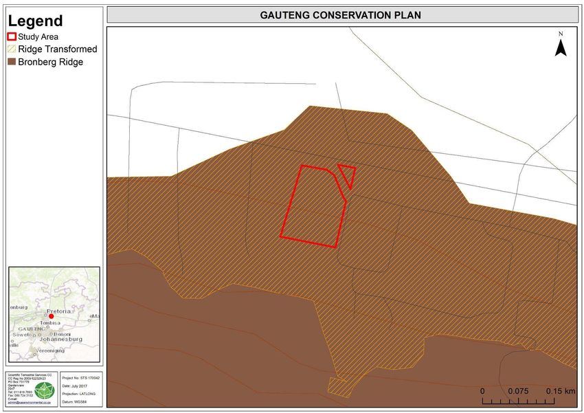
FIGURE 5: THE BRONBERG RIDGE ASSOCIATED WITH THE STUDY AREA .............................................................................. 23
FIGURE 6: REGION 6 WITHIN THE CITY OF TSHWANE METROPOLITAN MUNICIPALITY.......................................................... 25
LIST OF TABLES
TABLE 1: METHODOLOGY ....................................................................................................................................... 36
TABLE 2: METHODS USED TO DETERMINE THE CONSEQUENCE SCORE .............................................................................. 37
TABLE 3: PROBABILITY CLASSIFICATION ...................................................................................................................... 37
TABLE 4: IMPACT SIGNIFICANCE RATING .................................................................................................................... 37
TABLE 5: IMPACT STATUS AND CONFIDENCE CLASSIFICATION .......................................................................................... 38
TABLE 6: POTENTIAL IMPACTS FOR THE CONSTRUCTION AND OPERATIONAL PHASE - PROPOSAL ............................................ 38
TABLE 7: POTENTIAL IMPACTS FOR THE CONSTRUCTION AND OPERATIONAL PHASE - ALTERNATIVE 1 ...................................... 41
TABLE 8: SIGNIFICANCE RATING FOR THE CONSTRUCTION AND OPERATIONAL PHASE - PROPOSAL .......................................... 41
TABLE 9: SIGNIFICANCE RATING FOR THE CONSTRUCTION AND OPERATIONAL PHASE - ALTERNATIVE 1.................................... 47
TABLE 10: SUMMARY OF IDENTIFIED IMPACTS – PROPOSAL ........................................................................................... 50
TABLE 11: SUMMARY OF IDENTIFIED IMPACTS – ALTERNATIVE 1 .................................................................................... 51
DRAFT BASIC ASSESSMENT REPORT iii
PROPOSED HOSPITAL EXTENSION - DIE WILGERS EXT 83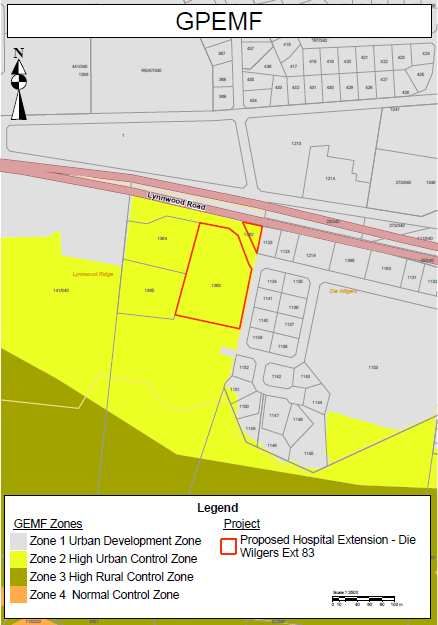
APPENDICES
Appendix A: Site plan(s)
Appendix B: Photographs
Appendix C: Facility illustration(s)
Appendix D: Route position information
Appendix E: Public participation information
        •    Appendix 1 – Proof of site notice
        •    Appendix 2 – Written notices issued to I&APs and Stakeholders
        •    Appendix 3 – Proof of newspaper advertisements
        •    Appendix 4 – Communications to and from I&APs and Stakeholders
        •    Appendix 5 – Minutes of any public and/or stakeholder meetings
        •    Appendix 6 – Comments and Responses Report
        •    Appendix 7 – Comments from I&APs on Basic Assessment (BA) Report
        •    Appendix 8 – Comments from I&APs on amendments to the BA Report
        •    Appendix 9 – Copy of the register of I&APs
        •    Appendix 10 – Comments from I&APs on the application
        •    Appendix 11 – Other
Appendix F: Water use license(s) authorisation, SAHRA information, service letters from
               municipalities, water supply information
Appendix G: Specialist Reports
Appendix H: EMPr
Appendix I: Other information

DRAFT BASIC ASSESSMENT REPORT                                                   iv
PROPOSED HOSPITAL EXTENSION - DIE WILGERS EXT 83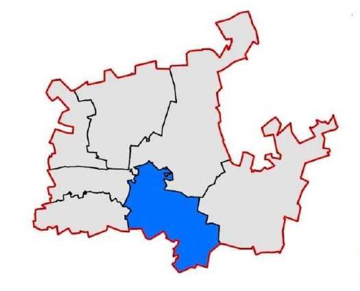
DEFINITIONS
Activity             An action either planned or existing that may result in environmental impacts
(Development)        through pollution or resource use. For the purpose of this report, the terms
                     ‘activity’ and ‘development’ are freely interchanged.
Alternatives         Different means of meeting the general purpose and requirements of the
                     activity, which may include site or location alternatives; alternatives to the
                     type of activity being undertaken; the design or layout of the activity; the
                     technology to be used in the activity and the operational aspects of the
                     activity.
Applicant            The project proponent or developer responsible for submitting an
                     environmental application to the relevant environmental authority for
                     environmental authorisation.
Biodiversity         The diversity of animals, plants and other organisms found within and
                     between ecosystems, habitats, and the ecological complexes.
Construction         The building, erection or establishment of a facility, structure or infrastructure
                     that is necessary for the undertaking of a listed or specified activity but
                     excludes any modification, alteration or expansion of such a facility, structure
                     or infrastructure and excluding the reconstruction of the same facility in the
                     same location, with the same capacity and footprint.
Cumulative           The impact of an activity that in itself may not be significant but may become
impact               significant when added to the existing and potential impacts eventuating from
                     similar or diverse activities or undertakings in the area.
Decommissioning      The demolition of a building, facility, structure or infrastructure.
Direct Impact        Impacts that are caused directly by the activity and generally occur at the
                     same time and at the same place of the activity. These impacts are usually
                     associated with the construction, operation or maintenance of an activity and
                     are generally quantifiable.
Ecosystem            A dynamic system of plant, animal (including humans) and micro-organism
                     communities and their non-living physical environment interacting as a
                     functional unit. The basic structural unit of the biosphere, ecosystems are
                     characterised by interdependent interaction between the component species
                     and their physical surroundings. Each ecosystem occupies a space in which
                     macro-scale conditions and interactions are relatively homogenous
Environment          In terms of the National Environmental Management Act (NEMA) (No 107 of
                     1998)(as amended), “Environment” means the surroundings within which
                     humans exist and that are made up of:
                     a) the land, water and atmosphere of the earth;
                     b) micro-organisms, plants and animal life;
                     c) any part or combination of (i) of (ii) and the interrelationships among and
                     between them; and
                     d) the physical, chemical, aesthetic and cultural properties and conditions of
                     the foregoing that influence human health and wellbeing.
Environmental        The generic term for all forms of environmental assessment for projects,
Assessment           plans, programmes or policies and includes methodologies or tools such as
                     environmental impact assessments, strategic environmental assessments
                     and risk assessments.
Environmental        An authorisation issued by the competent authority in respect of a listed
Authorisation        activity, or an activity which takes place within a sensitive environment.]
Environmental        The individual responsible for planning, management and coordination of
Assessment           environmental impact assessments, strategic environmental assessments,
Practitioner (EAP)   environmental management programmes or any other appropriate
                     environmental instrument introduced through the EIA Regulations.
Environmental        Ensuring that environmental concerns are included in all stages of
Management           development, so that development is sustainable and does not exceed the
                     carrying capacity of the environment.
Environmental        A detailed plan of action prepared to ensure that recommendations for
Management           enhancing or ensuring positive impacts and limiting or preventing negative

DRAFT BASIC ASSESSMENT REPORT                                                                  v
PROPOSED HOSPITAL EXTENSION - DIE WILGERS EXT 83
Programme          environmental impacts are implemented during the life cycle of a project. This
(EMPr)             EMPr focuses on the construction phase, operation (maintenance) phase and
                   decommissioning phase of the proposed project.
Environmental      Change to the environment (biophysical, social and/ or economic), whether
Impact             adverse or beneficial, wholly or partially, resulting from an organisation’s
                   activities, products or services.
Environmental      A concern raised by a stakeholder, interested or affected parties about an
Issue              existing or perceived environmental impact of an activity.
Fatal Flaw         Issue or conflict (real or perceived) that could result in developments being
                   rejected or stopped. In the context of an environmental impact assessment a
                   fatal flaw can be termed as an environmental issue that cannot be mitigated
                   by any means
General Waste      Household waste, construction rubble, garden waste and certain dry
                   industrial and commercial waste, which does not pose an immediate threat to
                   man or the environment.
Groundwater        Water in the ground that is in the zone of saturation from which wells, springs,
                   and groundwater run-off are supplied.
Hazardous Waste    Waste that may cause ill health or increase mortality in humans, flora and
                   fauna.
Hydrology          The science encompassing the behaviour of water as it occurs in the
                   atmosphere, on the surface of the ground, and underground.
Important areas    Sites that are important for the conservation of biodiversity in Gauteng;
                   (Gauteng C-Plan Version 3)
Indirect Impacts   Indirect or induced changes that may occur as a result of the activity. These
                   types if impacts include all of the potential impacts that do not manifest
                   immediately when the activity is undertaken or which occur at a different
                   place as a result of the activity.
Interested and     Any person, group of persons or organisation interested in or affected by an
Affected           activity; and any organ of state that may have jurisdiction over any aspect of
Party (I&AP)       the activity.
Irreplaceable      Sites, which are essential in meeting targets set for the conservation of
areas              biodiversity in Gauteng; (Gauteng C-Plan Version 3)
Mitigate           The implementation of practical measures designed to avoid, reduce or
                   remedy adverse impacts or enhance beneficial impacts of an action.
No-Go Option       In this instance the proposed activity would not take place, and the resulting
                   environmental effects from taking no action are compared with the effects of
                   permitting the proposed activity to go forward.
Public             A process in which potential interested and affected parties are given an
Participation      opportunity to comment on, or raise issues relevant to, specific matters.
Process
Rehabilitation     A measure aimed at reinstating an ecosystem to its original function and state
                   (or as close as possible to its original function and state) following activities
                   that have disrupted those functions.
Sensitive          Any environment identified as being sensitive to the impacts of the
Environments       development.
Significance       Significance can be differentiated into impact magnitude and impact
                   significance. Impact magnitude is the measurable change (i.e. magnitude,
                   intensity, duration and likelihood). Impact significance is the value placed on
                   the change by different affected parties (i.e. level of significance and
                   acceptability). It is an anthropocentric concept, which makes use of value
                   judgements and science-based criteria (i.e. biophysical, social and
                   economic).
Stakeholder        The process of engagement between stakeholders (the proponent,
Engagement         authorities and I&APs) during the planning, assessment, implementation
                   and/or management of proposals or activities.
Sustainable        Development which meets the needs of current generations without hindering
Development        future generations from meeting their own needs.
Undeveloped        means that no facilities, structures or infrastructure have been effected upon
                   the land or property during the preceding 10 years
Urban areas        means areas situated within the urban edge (as defined or adopted by the

DRAFT BASIC ASSESSMENT REPORT                                                              vi
PROPOSED HOSPITAL EXTENSION - DIE WILGERS EXT 83
competent authority), or in instances where no urban edge or boundary has
been defined of adopted, it refers to areas situated within the edge of built-up
areas
Vacant Means not occupied for the purpose of its lawful land use during the
preceding ten year period
Watercourse Means
(a) a river or spring;
(b) a natural depression in which water flows regularly or intermittently;
(c) a wetland, lake or dam into which, or from which, water flows; and
(d) any collection of water which the Minister may, by notice in the Gazette,
declare to be a watercourse, and a reference to a watercourse includes,
where relevant, its bed and bank
Wetland Means land which is transitional between terrestrial and aquatic systems
where the water table is usually at or near the surface, or the land is
periodically covered with shallow water, and which land in normal
circumstances supports or would support vegetation typically adapted to life
in saturated soil
DRAFT BASIC ASSESSMENT REPORT vii
PROPOSED HOSPITAL EXTENSION - DIE WILGERS EXT 83ABBREVIATIONS BID Background Information Document BSc Bachelor of Science CC Close Corporation C- Plan Gauteng Conservation Plan Version 3.3 DEA Department of Environmental Affairs DWS Department of Water and Sanitation GDARD Gauteng Department of Agriculture and Rural Development EAP Environmental Assessment Practitioner EIA Environmental Impact Assessment EISD Environment and Infrastructure Services Department EMPr Environmental Management Programme Ha Hectares HIA Heritage Impact Assessment I&APs Interested and Affected Parties IDP’s Integrated Development Plans Km Kilometers LDO Land Development Objectives m Meters NEMA National Environmental Management Act NDP The National Development Plan NGO’s Non-Governmental Organisations OHSA Occupational Health and Safety Act PHRA-G Provincial Heritage Resources Authority - Gauteng (Pty) Ltd Proprietary Limited RDL Red Data List RDP Reconstruction and Development Programme SAHRA South African Heritage Resources Agency SCC Species of Conservation Concern DRAFT BASIC ASSESSMENT REPORT viii PROPOSED HOSPITAL EXTENSION - DIE WILGERS EXT 83
Basic Assessment Report in terms of the National Environmental Management
Act, 1998 (Act No. 107 of 1998), as amended, and the Environmental Impact
Assessment Regulations, 2014 (Version 1)

Kindly note that:

1.   This Basic Assessment Report is the standard report required by GDARD in terms of the EIA Regulations, 2014.

2.   This application form is current as of 8 December 2014. It is the responsibility of the EAP to ascertain whether
     subsequent versions of the form have been published or produced by the competent authority.

3.   A draft Basic Assessment Report must be submitted, for purposes of comments within a period of thirty (30)
     days, to all State Departments administering a law relating to a matter likely to be affected by the activity to be
     undertaken.

4.   A draft Basic Assessment Report (1 hard copy and two CD’s) must be submitted, for purposes of comments
     within a period of thirty (30) days, to a Competent Authority empowered in terms of the National Environmental
     Management Act, 1998 (Act No. 107 of 1998), as amended to consider and decide on the application.

5.   Five (5) copies (3 hard copies and 2 CDs-PDF) of the final report and attachments must be handed in at offices of the
     relevant competent authority, as detailed below.

6.   The report must be typed within the spaces provided in the form. The size of the spaces provided is not necessarily
     indicative of the amount of information to be provided. The report is in the form of a table that can extend itself as each
     space is filled with typing.

7.   Selected boxes must be indicated by a cross and, when the form is completed electronically, must also be highlighted.

8.   An incomplete report may lead to an application for environmental authorisation being refused.

9.   Any report that does not contain a titled and dated full colour large scale layout plan of the proposed activities
     including a coherent legend, overlain with the sensitivities found on site may lead to an application for
     environmental authorisation being refused.

10. The use of “not applicable” in the report must be done with circumspection because if it is used in respect of material
    information that is required by the competent authority for assessing the application, it may result in the application for
    environmental authorisation being refused.

11. No faxed or e-mailed reports will be accepted. Only hand delivered or posted applications will be accepted.

12. Unless protected by law, and clearly indicated as such, all information filled in on this application will become public
    information on receipt by the competent authority. The applicant/EAP must provide any interested and affected party
    with the information contained in this application on request, during any stage of the application process.

13. Although pre-application meeting with the Competent Authority is optional, applicants are advised to have these
    meetings prior to submission of application to seek guidance from the Competent Authority.

DEPARTMENTAL DETAILS

Gauteng Department of Agriculture and Rural Development
Attention: Administrative Unit of the of the Environmental Affairs Branch
P.O. Box 8769
Johannesburg
2000

Administrative Unit of the of the Environmental Affairs Branch
Ground floor Diamond Building
11 Diagonal Street, Johannesburg

Administrative Unit telephone number: (011) 240 3377
Department central telephone number: (011) 240 2500

DRAFT BASIC ASSESSMENT REPORT                                                                                         1
PROPOSED HOSPITAL EXTENSION - DIE WILGERS EXT 83
(For official use only)
NEAS Reference Number:
File Reference Number:
Application Number:
Date Received:
If this BAR has not been submitted within 90 days of receipt of the application by the competent authority and
permission was not requested to submit within 140 days, please indicate the reasons for not submitting within
time frame.
N/A
Is a closure plan applicable for this application and has it been included in this report? NO
if not, state reasons for not including the closure plan.
The Activity applied for does not relate to the decommissioning or closure of a
facility and it is not envisaged that the development will be decommissioned.
Has a draft report for this application been submitted to a competent authority and all State
Departments administering a law relating to a matter likely to be affected as a result of this activity?
YES
Is a list of the State Departments referred to above attached to this report including their full contact
details and contact person? YES
If no, state reasons for not attaching the list.
Please refer to Appendix I
Have State Departments including the competent authority commented? NO
If no, why?
Comment from the State Departments and the competent authority on the Draft
Report is awaited.
DRAFT BASIC ASSESSMENT REPORT 2
PROPOSED HOSPITAL EXTENSION - DIE WILGERS EXT 83SECTION A: ACTIVITY INFORMATION
1. PROPOSAL OR DEVELOPMENT DESCRIPTION
Project title (must be the same name as per application form):
Proposed Hospital Extension – Die Wilgers Extension 83
Select the appropriate box
The application is for an upgrade The application is for a new Other,
of an existing development development X specify
Does the activity also require any authorisation other than NEMA EIA authorisation?
YES NO
If yes, describe the legislation and the Competent Authority administering such legislation
An application was submitted to the City of Tshwane Metropolitan Municipality in
terms of Section 16(4) of the City of Tshwane Land Use Management By-Law, 2016.
If yes, have you applied for the authorisation(s)? YES NO
If yes, have you received approval(s)? (attach in appropriate appendix) YES NO
2. APPLICABLE LEGISLATION, POLICIES AND/OR GUIDELINES
List all legislation, policies and/or guidelines of any sphere of government that are applicable to the application as
contemplated in the EIA regulations:
Title of legislation, policy or guideline: Administering Promulgation Date:
authority:
National Environmental Management Act, National & 27 November
1998 (Act No. 107 of 1998 as amended). Provincial 1998
NEMA EIA Regulations, 2014 (Government National 2014
Notice Nos. GN R982, R983, R984, R985) as Department of
amended 2017. Environmental
Affairs and
Activities listed under GN R985: GDARD
Activity 4 - The development of a road wider
than 4m with a reserve less than 13,5 metres.
c. Gauteng: iv. Sites identified as Critical
Biodiversity Areas (CBAs) or Ecological
Support Areas (ESAs) in the Gauteng
Conservation Plan or bioregional plans; v.
Sites identified within threatened ecosystems
listed in terms of the National Environmental
Management Act: Biodiversity Act (Act No. 10
of 2004).
Activity 12 - The clearance of an area of 300
square metres or more of indigenous
vegetation except where such clearance of
indigenous vegetation is required for
maintenance purposes undertaken in
accordance with a maintenance management
DRAFT BASIC ASSESSMENT REPORT 3
PROPOSED HOSPITAL EXTENSION - DIE WILGERS EXT 83plan. c. Gauteng: i. Within any critically
endangered or endangered ecosystem listed
in terms of section 52 of the NEMBA or prior
to the publication of such a list, within an area
that has been identified as critically
endangered in the National Spatial
Biodiversity Assessment 2004; ii. Within
Critical Biodiversity Areas or Ecological
Support Areas identified in the Gauteng
Conservation Plan or bioregional plans; or iii.
On land, where, at the time of the coming into
effect of this Notice or thereafter such land
was zoned open space, conservation or had
an equivalent zoning.
National Environmental Management: National 2004
Biodiversity Act (Act No. 10 of 2004) Department of
Environmental
Affairs and
GDARD
National Environmental Management: Waste National 2008
Act (Act No. 59 of 2008) (NEM:WA) Department of
Environmental
Affairs and
GDARD
National Water Act (Act No. 36 of 1998) Department of 1998
Water and
Sanitation
National Heritage Resources Act (Act No. 25 SAHRA 1999
of 1999)
Occupational Health & Safety Act (Act No. 85 National 2001
of 1993) (OHSA) as amended in July 2001, Government
Including Major Hazard Installation
Regulation, GNR 692, 30 July 2001.
Conservation of Agricultural Resources Act Department of 1983
(Act No. 43 of 1983) Agriculture
Forestry and
Fisheries
Reconstruction and Development Programme National & 1995
Provincial
National Development Plan National 2011
Planning
Commission
Gauteng Conservation Plan (C-Plan Version GDARD 2011
3.3)
Gauteng Provincial Environmental GDARD 2015
Management Framework
Gauteng Spatial Development Framework Provincial 2011
The Gauteng Department of Agriculture and Gauteng March 2014
Rural Development’s (GDARD) Requirements Department of
for Biodiversity Assessments (Version 3) Agriculture and
Rural
Development
Gauteng Spatial Development Framework Provincial 2011
Gauteng Planning and Development Act (Act Gauteng 2003
DRAFT BASIC ASSESSMENT REPORT 4
PROPOSED HOSPITAL EXTENSION - DIE WILGERS EXT 83No. 3 of 2003) Provincial
Legislature
City of Tshwane: Draft 2017/21 Integrated City of 2017
Development Plan Tshwane
Metropolitan
Municipality
City of Tshwane: Metropolitan Spatial City of June 2012
Development Framework (MSDF) Tshwane
Metropolitan
Municipality
City of Tshwane: Regional Spatial City of 2017
Development Framework (RSDF): Region 7 Tshwane
Metropolitan
Municipality
City of Tshwane By-Laws City of -
Tshwane
Metropolitan
Municipality
Description of compliance with the relevant legislation, policy or guideline:
Legislation, policy of Description of compliance
guideline
National NEMA establishes the basis for environmental governance
Environmental and sets out the principles for decision-making on matters
Management Act, affecting the environment. The principles of the Act are
1998 (Act No. 107 of provided in Section 2 and it is the responsibility of all organs
1998 as amended). of state to take these principles into account when making
decisions that could affect the environment.
The proposed development does not occur in contrast with
the principles and main objective of the Act.
NEMA EIA The EIA process, applicable to this application, is determined
Regulations, 2014 by the Environmental Impact Regulations published in
(Government Notice Government Notice R982 in Government Gazette No 38282 of
Nos. GN R982, 4 December 2014 promulgated under Chapter 5 of the
R983, R984, R985) National Environmental Management Act, 1998 (Act No. 107 of
as amended 2017. 1998) and amended in 2017.
The EIA regulations inter alia describe the procedure for EIA
and provide a description of activities that would require
authorisation through either 1) a Basic Assessment (in terms
of Government Notices R983 and R985 of 2014) or 2) Scoping
and Environmental Impact Assessment (in terms of
Government Notice R984 of 2014).
An application is submitted in terms of Chapter 4 of the EIA
Regulations as the proposed development triggers activities
that require a Basic Assessment.
National The objectives of this Act are:
Environmental
Management: Within the framework of the National Environmental
Biodiversity Act Management Act, to provide for –
(Act No. 10 of 2004) (i) the management and conservation of biological diversity
within the Republic and of the components of such
biological diversity;
DRAFT BASIC ASSESSMENT REPORT 5
PROPOSED HOSPITAL EXTENSION - DIE WILGERS EXT 83(ii) the use of indigenous biological resources in a
sustainable manner and
(ii) the fair and equitable sharing among stakeholders of
benefits arising from bioprospecting involving indigenous
biological resources.
The proposed development does not occur in contrast with
the objectives of the Act.
National The objective of this act is to protect health, well-being, and
Environmental the environment by providing measures for-
Management: • Minimising consumption of natural resources;
Waste Act (Act No. • Avoiding and minimising the generation of waste;
59 of 2008) • Reducing, reusing, recycling and recovering waste;
(NEM:WA) • Treating and safely disposing of waste as last resort;
• Preventing pollution and ecological degradation;
• Securing ecologically sustainable development while
promoting justifiable economic and social development.
The proposed development does not occur in contrast with
the objectives of the Act.
National Water Act The purpose of this Act is to ensure that the nation’s water
(Act No. 36 of 1998) resources are protected, used, developed, conserved,
managed and controlled in ways that takes into account
amongst other factors:
• Promoting equitable access to water
• Redressing the results of past racial and gender
discrimination;
• Promoting the efficient, sustainable and beneficial use of
water in the public interest;
• Facilitating social and economic development;
• Providing for growing demand for water;
• Protecting aquatic and associated ecosystems and their
biological diversity;
• Reducing and preventing pollution and degradation of
water resources;
• Meeting international obligations
• Promoting dam safety;
• Managing floods and drought.
The proposed development does not occur in contrast with
the objectives of the Act.
National Heritage Heritage resources have lasting value in their own right and
Resources Act (Act provide evidence of the origins of South African society and,
No. 25 of 1999) as they are valuable, finite, non-renewable and irreplaceable,
they must be carefully managed to ensure their survival.
A Heritage Impact Assessment is included under Appendix
G.
Occupational The main objective of the Act is to provide for the health and
Health & Safety Act safety of persons at work and for the health and safety of
(Act No. 85 of 1993) persons in connection with the use of plant and machinery;
(OHSA) as the protection of persons other than persons at work against
amended in July hazards to health and safety arising out of in connection with
2001, Including the activities of persons at work; to establish an advisory
DRAFT BASIC ASSESSMENT REPORT 6
PROPOSED HOSPITAL EXTENSION - DIE WILGERS EXT 83Major Hazard council for occupational health and safety; and to provide for
Installation matters connected herewith.
Regulation, GNR
692, 30 July 2001. The proposed development site and crew are to be managed
in strict accordance with the Occupational Health and Safety
Act (Act No. 85 of 1993) (OHSA) and the National Building
Regulations.
Conservation of The proposed development will ensure that no agricultural
Agricultural resources are impacted upon.
Resources Act (Act
No. 43 of 1983)
Reconstruction and One of the six principles of the Reconstruction and
Development Development programme is meeting basic needs and
Programme building the infrastructure.
The RDP integrates growth, development, reconstruction,
redistribution and reconciliation into a unified programme.
The key link is an infrastructural programme that will provide
access to modern and effective services such as electricity,
water, telecommunications, transport, health, education and
training for all our people.
The proposed development does not contrast with one of the
six principles of the RDP.
National The National Development Plan (NDP) offers a long-term
Development Plan perspective. It defines a desired destination and identifies the
role different sectors of society need to play in reaching that
goal.
As a long-term strategic plan, it serves four broad objectives:
• Providing overarching goals for what the nation want to
achieve by 2030.
• Building consensus on the key obstacles to us achieving
these goals and what needs to be done to overcome
those obstacles.
• Providing a shared long-term strategic framework within
which more detailed planning can take place in order to
advance the long-term goals set out in the NDP.
• Creating a basis for making choices about how best to
use limited resources.
The Plan aims to ensure that all South Africans attain a
decent standard of living through the elimination of poverty
and reduction of inequality. The core elements of a decent
standard of living identified in the Plan are:
• Housing, water, electricity and sanitation
• Safe and reliable public transport
• Quality education and skills development
• Safety and security
• Quality health care
• Social protection
• Employment
• Recreation and leisure
• Clean environment
DRAFT BASIC ASSESSMENT REPORT 7
PROPOSED HOSPITAL EXTENSION - DIE WILGERS EXT 83• Adequate nutrition
The proposed development does not occur in contrast with
the NDP.
Gauteng GDARD’s (Gauteng Department of Agriculture and Rural
Conservation Plan Development) C-Plan (Gauteng Conservation Plan Version
(C-Plan Version 3.3) 3.3) was used to determine the sensitivities of the site and is
provided in the figure below.
Conservation planning was started in Gauteng in the year
2000 and the aim was to revise the C-Plan at least every 5
years. C-Plan Version 1 was produced in 2001 and was
followed by version 2 in 2005. Version 2 was refined in 2007
and was named Version 2.1. The small size of the province
made it feasible to conduct an extensive biodiversity survey,
named BGAP, which aimed to provide the information on
spatial occurrence of biodiversity necessary for rigorous
conservation planning. C-Plan 3 represents priority areas for
biodiversity conservation in the Gauteng province.
An extract of the sensitivities that could affect the site in
terms of the C-Plan is provided below for ease of reference.
DRAFT BASIC ASSESSMENT REPORT 8
PROPOSED HOSPITAL EXTENSION - DIE WILGERS EXT 83Figure 1: C-Plan
According to GDARD’s conservation plan (C-Plan version
3.3), the entire study area is situated within a CBA. The CBA
is considered an irreplaceable area, for red listed plant and
mammal habitat and for primary vegetation.
Gauteng Provincial The guiding objectives that emerged during the course of the
Environmental development of the GEMF are:
Management • To facilitate the optimal use of current industrial, mining
Framework land and other suitable derelict land for the development of
non-polluting industrial and large commercial
developments.
• To protect Critical Biodiversity Areas (CBAs as defined in
C-Plan 3.3) within urban and rural environments.
• To ensure the proper integration of Ecological Support
Areas (ESAs as defined in C-Plan 3.3) into rural land use
DRAFT BASIC ASSESSMENT REPORT 9
PROPOSED HOSPITAL EXTENSION - DIE WILGERS EXT 83change and development.
• To use ESAs as defined in municipal bioregional plans in
spatial planning of urban open space corridors and links
within urban areas.
• To focus on the sustainability of development through the
implementation of initiatives such as:
Energy efficiency programmes, plans and designs;
Waste minimisation, reuse and recycling;
Green infrastructure in urban areas; and
Sustainable Drainage Systems (SuDS).
The Environmental Management Zones (EMZ) were derived
from the desired state, the environmental sensitivity as well
the unique control areas as identified in sections 1, 2 and 3.
The EMZs were also presented to the Gauteng Planning
Forum 6 where it was generally accepted as a suitable
contribution to facilitate appropriate development in Gauteng.
The EMZs also took the Gauteng Growth and Management
Perspective, 2014, into account and is therefore aligned to the
general development policy for Gauteng.
Five EMZs were identified and overlaying those a further six
Special Management Areas were identified where specific
planning and policy measures are necessary to achieve the
development objective of those areas.
According to the GPEMF, the site is identified as the following
Environmental Management Zone:
Zone 2: High Urban Control Zone
An extract of the zones that could affect the site in terms of
the GPEMF is provided below for ease of reference.
DRAFT BASIC ASSESSMENT REPORT 10
PROPOSED HOSPITAL EXTENSION - DIE WILGERS EXT 83Figure 2: GPEMF
Gauteng Spatial The GSDF are in pursuit of planning for shared, equitable,
Development sustainable and inclusive growth and development in the
Framework country. The Gauteng Provincial Government (GPG) seeks to:
• provide a clear future provincial spatial structure that is
robust to accommodate growth and sustainability;
• specify a clear set of spatial objectives for municipalities
to achieve in order to ensure realisation of the future
provincial spatial structure;
• propose a set of plans that municipalities have to prepare
in their pursuit of these objectives;
• provide a common language and set of shared planning
constructs for municipalities to use in their planning
processes and plans; and
• enable and direct growth.
DRAFT BASIC ASSESSMENT REPORT 11
PROPOSED HOSPITAL EXTENSION - DIE WILGERS EXT 83The proposed development does not occur in contrast with
the objectives of the GPG.
The Gauteng The document provides guidelines for the minimum
Department of requirements for all biodiversity assessments when
Agriculture and development is proposed.
Rural
Development’s A Terrestrial Ecological Habitat Integrity Investigation was
(GDARD) conducted and is included under Appendix G. Based on the
Requirements for findings of the assessment, it is the opinion of the ecologists
Biodiversity that from an ecological perspective, the proposed project be
Assessments considered favorably. However, all essential mitigation
(Version 3) measures and recommendations presented in the report
should be adhered to as to ensure that the impact on the
receiving environment is minimized.
City of Tshwane: According to Section 25 of the Local Government: Municipal
Draft 2017/21 Systems Act, 2000 (Act 32 of 2000), each municipal council
Integrated must, after the start of its elected term, adopt a single,
Development Plan inclusive and strategic plan (Integrated Development Plan or
IDP) for the development of the municipality which links,
integrates and coordinates plans and takes into account
proposals for the development of the municipality and which
aligns the resources and capacity of the municipality with the
implementation of the said plan.
An Integrated Development Plan is a super plan for an area
that gives an overall framework for development. It aims to
co-ordinate the work of local and other spheres of
government in a coherent plan to improve the quality of life
for all the people living in an area. It takes into account the
existing conditions and problems and resources available for
development. It looks at economic and social development for
the area as a whole. It is used by municipalities as a tool to
plan short and long term future development.
The 2017/21 IDP is the first IDP for the 2017–2021 term of
office. It sets the agenda for the term of office, which will
focus on the following three strategic framers: stabilisation,
revitalisation and delivery.
The following are the strategic pillars that will guide the
development in the term of office:
• City that facilitates economic growth and job creation
• City that cares for residents and promotes inclusivity
• City that delivers excellent services and protects the
environment
• City that keeps residents safe
• City that is open, honest and responsive
The proposed development does not occur in contrast with
the IDP.
City of Tshwane: Every great city has a vision. In order to realise that vision, a
Metropolitan Spatial strategy that responds to the various elements of that vision
Development is required. The vision of the CoT is to become the African
DRAFT BASIC ASSESSMENT REPORT 12
PROPOSED HOSPITAL EXTENSION - DIE WILGERS EXT 83Framework (MSDF) Capital City of Excellence.
The purpose of a spatial framework for the city is to provide a
spatial representation of the City Vision and to be a tool to
integrate all aspects of spatial (physical) planning such as
land use planning; planning of a pedestrian, vehicular and
other movement patters; planning regarding buildings and
built-up areas; planning of open space systems; planning of
roads and other service infrastructure; as well as to guide all
decision-making processes regarding spatial (physical)
development.
The MSDF aims to address the following towards the
achievement of the City vision:
• Addressing social need
• Restructuring of a spatially inefficient City
• Promotion of sustainable use of land resources
• Strategic direction around infrastructure provision
• Creating opportunities for both rural and urban areas
• Guiding developers and investors as to appropriate
investment localities
• Rural management programmes to improve livelihoods and
stimulate employment.
The proposed development does not occur in contrast with
the MSDF.
City of Tshwane: The City of Tshwane (COT) embarked on processes to
Regional Spatial compile seven Regional Spatial Development Frameworks
Development (RSDF’s) for the administrative planning regions of the
Framework (RSDF): metropolitan area in 2011.
Region 6
The RSDF’s needed to be inter-linked and also support the
Tshwane Metropolitan Spatial Development Framework
(MSDF) of 2017 as well as the Tshwane City Development
Strategy (CDS), Tshwane Densification and Compaction
Strategy (2005) and Tshwane Open Space Framework.
The RSDF for Region 6 was therefore prepared within the
context of the MSDF, the City Development Strategy and in
support of the other RSDF’s.
A Spatial Development Framework must:
• Indicate where public and private development
infrastructure investment should take place.
• Indicate desired development and land use patterns for
different areas.
• Indicate where development of particular land uses should
be discouraged or restricted.
• Provide broad indication of the areas where priority
spending should take place.
• Shall provide guidelines for development and land use
decision-making by the municipality.
The proposed development does not occur in contrast with
DRAFT BASIC ASSESSMENT REPORT 13
PROPOSED HOSPITAL EXTENSION - DIE WILGERS EXT 83the RSDF. City of Tshwane By- The proposed development will be constructed to comply Laws with the City of Tshwane By-Laws DRAFT BASIC ASSESSMENT REPORT 14 PROPOSED HOSPITAL EXTENSION - DIE WILGERS EXT 83
3.    ALTERNATIVES
Describe the proposal and alternatives that are considered in this application. Alternatives should include a consideration of
all possible means by which the purpose and need of the proposed activity could be accomplished. The determination of
whether the site or activity (including different processes etc.) or both is appropriate needs to be informed by the specific
circumstances of the activity and its environment.

The no-go option must in all cases be included in the assessment phase as the baseline against which the impacts of the
other alternatives are assessed. Do not include the no go option into the alternative table below.

Note: After receipt of this report the competent authority may also request the applicant to assess additional alternatives that
could possibly accomplish the purpose and need of the proposed activity if it is clear that realistic alternatives have not been
considered to a reasonable extent.

Please describe the process followed to reach (decide on) the list of alternatives below

Lokisa was provided with 2 different options for the layout of the proposed Hospital
Extension.

Provide a description of the alternatives considered

No.    Alternative      Description
       type, either
       alternative:
       site on
       property,
       properties,
       activity,
       design,
       technology,
       energy,
       operational
       or
       other(provid
       e details of
       “other”)

1      Proposal         The project entails the proposed expansion of the existing Life
                        Wilgers Hospital. The project site measures approximately 1.7ha in
                        extent.

                        The property is known as Portion 161 of the farm The Willows 340
                        JR. A previous township was approved over the portion of land and
                        the General Plan (Die Wilgers Ext 83) was subsequently approved.
                        However, the rights that were obtained were not suitable for the
                        intended use and the township process was also not finalised.

                        The site is to be developed in two portions being Site A (to be
                        known as Erf 1374 of Die Wilgers x 83) and Site B (to be known as
                        Erf 1375 of Die Wilgers x 83).

                        Site A /Erf 1374 is to be developed with a Hospital and related and
                        subservient uses, medical consulting rooms, parking, helipad, a
                        cafeteria, a florist, a kiosk and a dispensing chemist with a height of
                        3 storeys.

                        Site B /Erf 1375 is to be used for parking purposes.

                        The south western portion of Erf 1374 has been excluded from the
                        development and a servitude is to be registered for the Natural

DRAFT BASIC ASSESSMENT REPORT                                                                                       15
PROPOSED HOSPITAL EXTENSION - DIE WILGERS EXT 83
Conservation: Juliana’s Golden Mole.
The site is situated approximately 4.79km east of Lynnwood, 2.11km
north of Faerie Glen, 1.94km west of Equestria and directly south of
the M6 Road, also known as Lynnwood Road.
Figure 3: Locality of the proposed project
Figure 4: Site Plan
DRAFT BASIC ASSESSMENT REPORT 16
PROPOSED HOSPITAL EXTENSION - DIE WILGERS EXT 832 Alternative 1 Alternative 1 will be similar to the Proposal but for the south
western portion of Erf 1374, which will be left in its current state.
The existing trees will therefore not be removed.
3 Alternative 2 No other alternative presented.
Etc.
In the event that no alternative(s) has/have been provided, a motivation must be included in the table below.
4. PHYSICAL SIZE OF THE ACTIVITY
Indicate the total physical size (footprint) of the proposal as well as alternatives. Footprints are to include all new
infrastructure (roads, services etc), impermeable surfaces and landscaped areas:
Size of the activity:
Proposed activity (Total environmental (landscaping, parking, etc.) ± 1.7 Ha
and the building footprint)
Alternatives:
Alternative 1 (if any) ± 1.7 Ha
Alternative 2 (if any)
Ha/ m2
or, for linear activities:
Length of the activity:
Proposed activity
Alternatives:
Alternative 1 (if any)
Alternative 2 (if any)
m/km
Indicate the size of the site(s) or servitudes (within which the above footprints will occur):
Size of the site/servitude:
Proposed activity ± 1.7 Ha
Alternatives:
Alternative 1 (if any) ± 1.7 Ha
Alternative 2 (if any)
Ha/m2
5. SITE ACCESS
Proposal
Does ready access to the site exist, or is access directly from an existing road? YES NO
If NO, what is the distance over which a new access road will be built m
Describe the type of access road planned:
Include the position of the access road on the site plan (if the access road is to traverse a sensitive feature the impact
thereof must be included in the assessment).
Alternative 1
Does ready access to the site exist, or is access directly from an existing road? YES NO
If NO, what is the distance over which a new access road will be built m
Describe the type of access road planned:
Include the position of the access road on the site plan. (if the access road is to traverse a sensitive feature the impact
thereof must be included in the assessment).
Alternative 2
Does ready access to the site exist, or is access directly from an existing road? YES NO
If NO, what is the distance over which a new access road will be built m
Describe the type of access road planned:
Include the position of the access road on the site plan. (if the access road is to traverse a sensitive feature the impact
thereof must be included in the assessment).
DRAFT BASIC ASSESSMENT REPORT 17
PROPOSED HOSPITAL EXTENSION - DIE WILGERS EXT 83PLEASE NOTE: Points 6 to 8 of Section A must be duplicated
where relevant for alternatives
Section A 6-8 has been duplicated Number of times
(only complete when applicable)
6. LAYOUT OR ROUTE PLAN
A detailed site or route (for linear activities) plan(s) must be prepared for each alternative site or alternative activity. It must
be attached to this document. The site or route plans must indicate the following:
the layout plan is printed in colour and is overlaid with a sensitivity map (if applicable);
layout plan is of acceptable paper size and scale, e.g.
o A4 size for activities with development footprint of 10sqm to 5 hectares;
o A3 size for activities with development footprint of ˃ 5 hectares to 20 hectares;
o A2 size for activities with development footprint of ˃20 hectares to 50 hectares);
o A1 size for activities with development footprint of ˃50 hectares);
The following should serve as a guide for scale issues on the layout plan:
o A0 = 1: 500
o A1 = 1: 1000
o A2 = 1: 2000
o A3 = 1: 4000
o A4 = 1: 8000 (±10 000)
shapefiles of the activity must be included in the electronic submission on the CD’s;
the property boundaries and Surveyor General numbers of all the properties within 50m of the site;
the exact position of each element of the activity as well as any other structures on the site;
the position of services, including electricity supply cables (indicate above or underground), water supply pipelines,
boreholes, sewage pipelines, septic tanks, storm water infrastructure;
servitudes indicating the purpose of the servitude;
sensitive environmental elements on and within 100m of the site or sites (including the relevant buffers as prescribed by
the competent authority) including (but not limited thereto):
o Rivers and wetlands;
o the 1:100 and 1:50 year flood line;
o ridges;
o cultural and historical features;
o areas with indigenous vegetation (even if it is degraded or infested with alien species);
Where a watercourse is located on the site at least one cross section of the water course must be included (to allow the
position of the relevant buffer from the bank to be clearly indicated)
FOR LOCALITY MAP (NOTE THIS IS ALSO INCLUDED IN THE APPLICATION FORM REQUIREMENTS)
the scale of locality map must be at least 1:50 000. For linear activities of more than 25 kilometres, a smaller scale e.g.
1:250 000 can be used. The scale must be indicated on the map;
the locality map and all other maps must be in colour;
locality map must show property boundaries and numbers within 100m of the site, and for poultry and/or piggery, locality
map must show properties within 500m and prevailing or predominant wind direction;
for gentle slopes the 1m contour intervals must be indicated on the map and whenever the slope of the site exceeds
1:10, the 500mm contours must be indicated on the map;
areas with indigenous vegetation (even if it is degraded or infested with alien species);
locality map must show exact position of development site or sites;
locality map showing and identifying (if possible) public and access roads; and
the current land use as well as the land use zoning of each of the properties adjoining the site or sites.
Refer to Appendix A for the Site Plans
7. SITE PHOTOGRAPHS
Colour photographs from the center of the site must be taken in at least the eight major compass directions with a
description of each photograph. Photographs must be attached under the appropriate Appendix. It should be supplemented
with additional photographs of relevant features on the site, where applicable.
Refer to Appendix B for the Site Photographs
8. FACILITY ILLUSTRATION
DRAFT BASIC ASSESSMENT REPORT 18
PROPOSED HOSPITAL EXTENSION - DIE WILGERS EXT 83You can also read


