Reduction of Greenhouse Gas Emissions and Land Use Planning
←
→
Page content transcription
If your browser does not render page correctly, please read the page content below
ces   Guide
                     t Practi
                  Bes

Reduction of Greenhouse
Gas Emissions and
Land Use Planning
This publication was produced by the ministère des Affaires municipales et des Régions (MAMR).

This text was translated from french.

The following branches collaborated in the development of the guide:
Ministère des Affaires municipales et des Régions
> Direction de la planification et de la recherche
> Direction de l’aménagement et du développement local
> Direction des infrastructures
> Direction des politiques municipales et urbaines

Ministère du Développement durable, de l’Environnement et des Parcs
> Bureau des changements climatiques

The MAMR also wishes to acknowledge the collaboration of Vivre en Ville for adding this new
title, in the form of a CD-ROM, to its Trousse d’actions - Vers des collectivités viables.

Research
Mathieu Langlois, with the collaboration of Karine Bonneville, Direction de la planification et
de la recherche

Editing
Pierre Blais, urban planner, with the collaboration of Mathieu Langlois, Direction de la
planification et de la recherche

Acknowledgements

We would like to thank, in particular, the resource persons from the municipalities consulted for
the descriptions of best practices presented in this guide.

Production
Service de l’information et de l’édition, Direction des communications

Graphic design
Corsaire design

Cover photo: Québec, Claude Chabot

This publication is also available on the department’s Web site (www.mamr.gouv.qc.ca).

Legal deposit
National Library of Canada
Bibliothèque nationale du Québec
ISBN 2-550-45817-6

© Gouvernement du Québec, 2005

    Reduction of Greenhouse Gas Emissions and Land Use Planning   2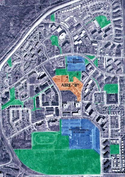
TABLE OF CONTENTS

INTRODUCTION                                                                    5
1 REDUCTION OF GREENHOUSE GAS EMISSIONS AND
  LAND USE PLANNING                                                             7
1.1   Greenhouse gases                                                          7
1.2   Emission sources                                                          9
1.3   Land use planning challenges related to urbanization models              11
2 STRATEGIES TO REDUCE GREENHOUSE GAS EMISSIONS                                13
2.1   Urbanization Management                                                  13
2.1.1 Consolidate and structure urbanization for the agglomeration             17
      Strategies                                                               17
      Means of action                                                          19
CASE STUDIES

      Longueuil: Consolidation of urbanization through the development of
      the area along boulevard Taschereau                                      21
      Drummondville: Planning and development of commercial spaces             24
2.1.2 Consolidate and revitalize city centres and central neighbourhoods       26
      Strategy                                                                 26
      Means of action                                                          28
CASE STUDIES

      Québec: Revival of the Saint-Roch area, the Lower Town business centre   30
      Montréal: The Angus project and the redevelopment of a run-down
      industrial site                                                          32
      Gatineau: Residential revival on the Île de Hull                         35
      Trois-Rivières: Revitalization of Vieux-Trois-Rivières and surrounding
      downtown neighbourhoods                                                  38
2.1.3 Increase density and diversify use in urbanized peripheral zones         39
      Strategy                                                                 39
      Means of action                                                          42
CASE STUDIES

      Québec: Comprehensive plan for the Faubourg Laudance area and
      its centre, rue du Campanile                                             43
      Gatineau: The development of a multipurpose regional centre              46

3     Reduction of Greenhouse Gas Emissions and Land Use Planning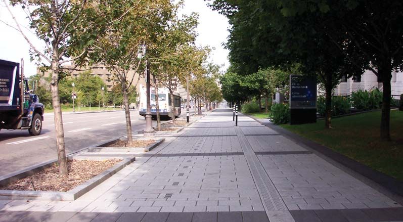
2.2     The development of transportation infrastructure                          49
2.2.1 Design an integrated transportation infrastructure network in accordance
      with urbanization management strategies                                     49
        Strategy                                                                  49
        Means of action                                                           54
CASE STUDIES

        Châteauguay: Planning a bikeway network for the entire city               55
        Baie-Comeau: A strategic cycle path to better integrate urbanized areas   56
        Québec: The utilitarian nature of the bicycle path on chemin des
        Quatre-Bourgeois                                                          56
2.3     Urban forests                                                             57
2.3.1 Reforest open space and protect green spaces                                57
        Strategy                                                                  57
        Means of action                                                           60
CASE STUDIES

        Québec: A master plan for the natural environment and urban forests       62
        Montréal: Green space protection on Île-des-Soeurs                        64
        Victoriaville: A well established urban forestry policy                   66
        Other noteworthy practices                                                67
BIBLIOGRAPHY                                                                      69
GLOSSARY OF TERMS USED IN THE ACT RESPECTING LAND USE PLANNING
AND DEVELOPMENT                                                                   70
GLOSSARY OF TERMS PERTAINING TO GREENHOUSE GASES                                  76

      Reduction of Greenhouse Gas Emissions and Land Use Planning   4
INTRODUCTION
   Land use planning strategies can help reduce greenhouse gas emissions.

                          The international scientific community recognizes that the increase in greenhouse gases
                          (GHG) is one of the leading causes of climate change, and that its consequences will
                          be increasingly felt in the coming decades.
                          In Québec, greenhouse gas emissions stemming from human activity reached an
                          estimated 81.9 million tonnes of CO2 equivalent in 1991 and 83.4 million tonnes in
                          1996.
                          If nothing is done to check such emissions, they will reach 94.1 million tonnes in 2011
                          and 105.1 million tonnes in 2026.1 It is against this backdrop, in keeping with the
                          United Nations Framework Convention on Climate Change and in conjunction with
                          talks stemming from the ratification of the Kyoto Protocol, that Québec has adopted an
                          action plan to reduce greenhouse gas emissions.
                          This guide stems from the Québec Action Plan on Climate Change2 and is intended for
                          land use planning and development policies to take into account the objective of
                          reducing greenhouse gas emissions.
                          It is in this perspective that the guide is aimed, first and foremost, at stakeholders in the
                          municipal sector, whether they are elected representatives, professionals, members of
                          urban planning or land use planning committees, or residents. It is also intended for
                          individuals in government departments or other public or private organizations whose
                          sphere of action can significantly impact land use development and transportation.

  This guide stems from
the Québec Action Plan
     on Climate Change

                          1 Gouvernement du Québec, Comité interministériel sur les changements climatiques, Problématique des transports et des
                              changements climatiques au Québec — Rapport du groupe de travail sur les transports, November 1999, page 7.
                          2 Gouvernement du Québec, Québec Action Plan on Climate Change 2000-2002 [online], 2000, 42 pages
                              (http:www.mddep.gouv.qc.ca/changements/plan-action.pdf

                          5         Reduction of Greenhouse Gas Emissions and Land Use Planning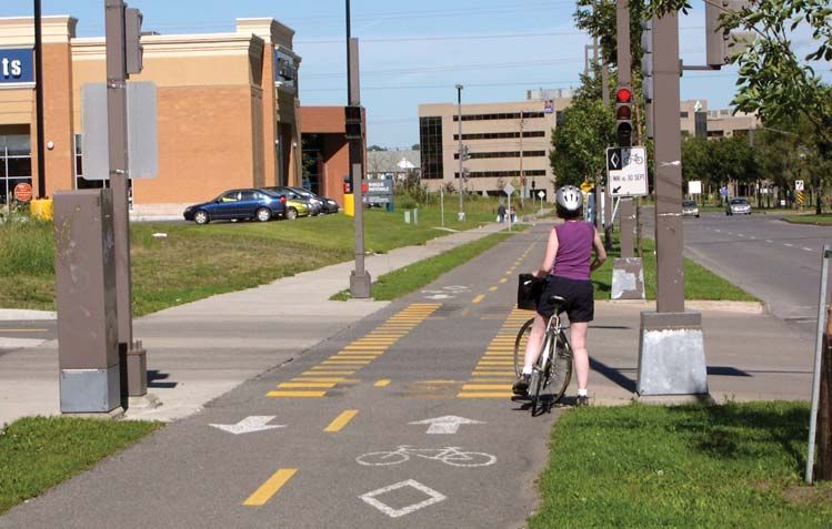
The guide is intended specifically to:
> review the issues related to climate change and the need to reduce greenhouse gas
  emissions;
> promote, in keeping with the government’s land use planning orientations, strategies
  that help to reduce greenhouse gas emissions;
> show how planning, regulatory and other tools provided by the Act respecting land
  use planning and development can be used to implement such strategies;
> present case studies of Québec municipalities where land use planning strategy
  initiatives contribute to the reduction of greenhouse gas emissions.
In particular, it focuses on urbanization models that are likely to reduce pollutants
produced by the transportation sector, the leading source of greenhouse gas emissions
of human origin in Québec. In this perspective, it emphasizes urbanization
management strategies that can have an impact on the choice of transportation mode,
the distances travelled and the number of automobile trips in urban areas.
The guide also defines complementary development strategies pertaining to
transportation infrastructure, urban forests and green spaces.

   Reduction of Greenhouse Gas Emissions and Land Use Planning   6
1 Reduction of Greenhouse Gas Emissions and
  Land Use Planning
  Greenhouse gas emissions can be reduced through a form of urbanization
  that makes it possible to reduce automobile trips.

                 1.1 Greenhouse gases
                 The greenhouse effect is a natural phenomenon whereby the Earth’s heat is trapped in
                 the atmosphere by certain gases. Greenhouse gases thus contribute to maintaining a
                 surface temperature on Earth favourable to life.
                 Industrialization and the population explosion that have occurred over the past 200
                 years have been accompanied by a substantial increase in the use of fossil fuels such as
                 coal, oil and natural gas, thus leading to an equally considerable increase in greenhouse
                 gas emissions in the atmosphere. The additional greenhouse gas emissions have in turn
                 exacerbated the greenhouse effect, which appears to be the cause of the increase in the
                 temperature of the Earth’s surface and the lower layers of its atmosphere.
                 Since 1860, according to the World Meteorological Organization, nine of the 10 hottest
                 years on a global scale occurred after 1990. Climatic warming is likely to increase
                 during the winter and in northern regions. In Québec, by 2050 or even earlier, climatic
                 change could lead to an temperature increase between 1°C and 6°C, in the south, and
                 between 2°C and 9°C, in the north, depending on the seasons.3

                3 Gouvernement du Québec, Québec Action Plan on Climate Change 2000-2002 [online], 2000, page 16
                 (http:www.mddep.gouv.qc.ca/changements/plan_action.pdf)

                 7       Reduction of Greenhouse Gas Emissions and Land Use Planning
CO2 and other greenhouse gases
                         To mitigate the impact of anticipated climate change (see box on page 10), the
                         international community has adopted the objective of reducing emissions of six
                         greenhouse gases (see page 76):
                         > carbon dioxide (CO2);
                         > methane (CH4);
                         > nitrous oxide (N2O);
                         > hydrofluorocarbons, sulphur hexafluoride and perfluorocarbons.
                         Among the six greenhouse gases mentioned, carbon dioxide is the leading greenhouse
                         gas stemming from human activities. For this reason, the volume of greenhouse gases in
                         the air is often expressed as tonnes of CO2 equivalent, which serves as a reference unit
                         for other gases.
                         The carbon cycle, which represents exchanges of carbon between terrestrial and
                         oceanic ecosystems, on the one hand, and the atmosphere, on the other, is now largely
                         affected by disturbances of human origin.

 Automobiles are the
   leading source of
   greenhouse gases
                                                                    Photo : Mathieu Langlois

         in Québec.

Industry is the second
source of greenhouse
    gases in Québec.
                                                                    Photo : Pierre Lahoud

                                                                                                                    Photo : Pierre Lahoud

                            Reduction of Greenhouse Gas Emissions and Land Use Planning        8
1.2         Emission sources
                           Figure 1 presents the breakdown of greenhouse gas emissions of human origin in 1990
                           and in 2001, in Québec. It also highlights the importance of the proportion of
                           greenhouse gas emissions stemming from transportation, which rose between 1990 and
                           2001, while emissions engendered by industry and electricity declined. Emissions from
                           each of the other sectors remained essentially stable.
                           The ministère des Ressources naturelles forecasts that, for the period 1996-2011, the
                           transportation sector will also account for most of the growth in greenhouse gas
                           emissions.4 It should be noted that, in addition to greenhouse gas emissions, the
                           transportation sector also contributes to other forms of air pollution such as smog and
                           acid rain.

CHART 1

      Greenhouse gas
             emissions                     Waste          Electricity                                                     Waste         Electricity
                                            6.9%
                                                    Other 1.7%                                                            6.1%
                                                                                                                                  Other 0.4%
  by source in Québec      Agriculture               0.3%                                                Agriculture              0.3%
    in 1990 and 2001       9.5%
                                                                         Industry                                                                     Industry
                                                                                                         10.1%
                                                                         34.7%                                                                        31.0%

                    Transportation                                                               Transportation
                                                          Residential,                                38.9%
                                                                                                                                       Residential,
                         33.9%                            commercial and                                                               commercial and
                                                          institutional                                                                institutional
                                                          12.9%                                                                        13.1%

                           Source: Ministère de l’Environnement du Québec,
                           October, 2003.

                           The automobile, principal source of greenhouse gases
                           The transportation sector and, in particular, automobile trips, are likely to be targeted in
                           order to attain greenhouse gas emission reduction objectives.
                           In 1996, automobiles and light trucks accounted for 76% of overall passenger-
                           kilometres. This proportion rises to nearly 90% when certain means of transportation
                           such as airplanes and trains are excluded.5 Nearly 84% of these trips occurred in urban
                           areas while 16% were intercity trips.
                           Even though the Montréal and Québec agglomerations contribute significantly to the
                           increase in greenhouse gas emissions because of the size of their population and the
                           number of trips that take place there, it is nonetheless important to consider that
                           medium-sized cities and smaller urban centres are also concerned by this.

                           4 Gouvernement du Québec, ministère des Ressources naturelles, Évolution de la demande d’énergie et des émissions de gaz
                               à effet de serre au Québec : scénario de référence 1996-2021. Québec, 2001, pages 28-29.
                           5 Gouvernement du Québec, Comité interministériel sur les changements climatiques, Problématique des transports et des
                               changements climatiques au Québec – Rapport du groupe de travail sur les transports, November 1999, page 68.

                           9          Reduction of Greenhouse Gas Emissions and Land Use Planning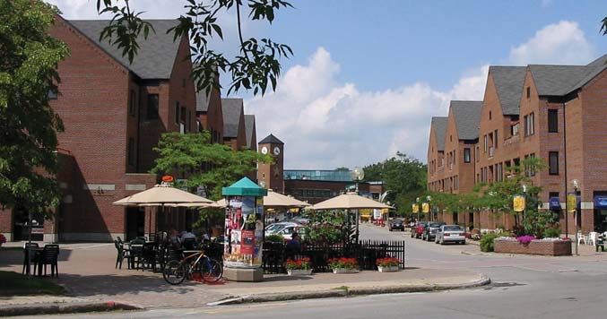
The impact of climate change                         Human health
on human activities                                  Individuals who already suffer from
                                                     allergies or cardiovascular and respiratory
Anticipated climate change will perma-
                                                     diseases may see their health deteriorate
nently affect the environment and human
                                                     because of climatic warming. Some
activity. Some examples:
                                                     population groups, such as the elderly,
Infrastructure and buildings                         sick individuals and children, could be
                                                     especially vulnerable to higher tempera-
Sewers may overflow more frequently in
                                                     tures.
the wake of heavier precipitation.
Moreover, roads are likely to be subject to
more frequent freezing and thawing
cycles. In some places, the erosion of
                                                     Perspective for land use
river banks may worsen, thus threatening             planning actions
infrastructure and buildings built along             Land use planning is one of the means
these.                                               that can be used to face these challenges
New design or location criteria governing            at the national, regional and local levels.
such infrastructure and buildings will               Actions may be developed with two
have to be considered, as the need arises.           different perspectives:
                                                     > Actions to reduce greenhouse gas
Water resources                                        emissions through sustainable manage-
Water resources are likely to be significantly         ment of urbanization by acting directly
affected. A reduction of the St. Lawrence              or indirectly on the principal sources of
River flow is feared. Furthermore, the                 human origin: this guide focuses on
normal flow of certain of its tributaries              this type of action;
could be altered by an increase in spring            > Actions to adapt to climate change
flooding and a reduction in summer                     focusing on prevention of and protec-
flows.                                                 tion from natural hazards (flood plains
These changes could affect water supply                or erosion zones), protection of banks
facilities and thus impact, domestic,                  and shores, local infrastructure plan-
industrial and agricultural uses.                      ning, and so on.

    Reduction of Greenhouse Gas Emissions and Land Use Planning   10
1.3 Land use planning challenges related to
urbanization models
Urban sprawl
Over the past 50 years, urban sprawl in the immediate vicinity of urban agglomerations
has increased ever more. Moreover, urban development has occurred in an
unstructured manner in rural areas. It has also appeared in existing cities and towns
located near or within several dozen kilometres of urban agglomerations.
The resulting urban areas:
> are characterized by low-density;
> have increased distances between residential areas and workplaces, businesses and
services;
> are hardly suited to modes of transportation other than the automobile;
> have relatively less attractive central areas: many have vacant lots and underused or
abandoned buildings.
Increase in automobile trips
This type of urban development generates motor vehicle trips that lead to substantial
greenhouse gas emissions and, more specifically, carbon dioxide (CO2) emissions.
Indeed, the automobile is the preferred if not the only possible choice for transportation,
to the detriment of mass transit, cycling or walking.
Moreover, in urban areas, an increase in the use of the automobile is accompanied by
an increase in the number of vehicle trips and in the distances traveled.
Improving accessibility between places of residence, work, consumption and other
types of activities, is important, since it will lead to fewer, less polluting trips. Actions
must focus on:
> the number of trips;
> the distances traveled;
> the means of travel.
Table 1 illustrates the variability in greenhouse gas emissions depending on the
transportation mode and distance traveled.
11 Reduction of Greenhouse Gas Emissions and Land Use PlanningTABLE 1
CO2 emissions (kg) Distance Automobile Commuter City Metro Walking
per person, (10 L/100 km) train bus or cycling
depending on the
transportation mode 1 person 2 people 3 people 110 people 40 people 120 people
and distance traveled
5 km 1.2 kg 0.6 kg 0.4 kg 0.2 kg 0.2 kg 0 kg 0 kg
10 km 2.4 kg 1.2 kg 0.8 kg 0.4 kg 0.3 kg 0 kg 0 kg
20 km 4.7 kg 2.4 kg 1.6 kg 0.8 kg 0.7 kg 0 kg 0 kg
50 km 11.8 kg 5.9 kg 4.0 kg 2.1 kg 1.7 kg 0 kg 0 kg
Source: Gouvernement du Québec, Agence de l’efficacité énergétique. Je lève le pied, je réduis les gaz, 2001.
Fewer, less polluting trips
In 1996, suburbanites in Québec and Montréal consumed twice as much energy for
automobile trips as their central zone residents did.6 This energy consumption pattern
is also found in medium-sized cities and the smaller urban centres in Québec, where
needs for motor vehicle transportation tend to increase from the central area to the
peripheral areas.
Land use planning measures that make it possible to reduce greenhouse gas emissions
should seek to develop urban centres that broaden the opportunities for a greater
number of people to make shorter, less frequent, less polluting trips.
Technological innovation and the design of new, less polluting vehicles are also
noteworthy ways of reducing greenhouse gas emissions. However, technological
innovation does not help in reducing traffic congestion or in alleviating other problems
stemming from urban sprawl. To reduce greenhouse gas emissions, it is preferable to
include both land use planning and technological innovation measures, rather than rely
solely on the latter.
6 Id., page 70.
Reduction of Greenhouse Gas Emissions and Land Use Planning 122 Strategies to Reduce Greenhouse Gas Emissions
Diversification of urban space is at the core of the proposed urbanization model.
Urbanization management is the main focus for the actions considered here. Two other
related fields are also considered, i.e. development of transportation infrastructure,
urban forests and green spaces.
For each action field, the guide defines strategies and specifies different types of means
that may be relevant. The means considered include: urban planning, regulations,
development funding, land assembly, and direct action such as urban redevelopment
projects, green space development.
Hyperlinks allow readers to access a glossary providing information on the terms used
in the Act respecting land use planning and development. This information is available
online in a document titled La prise de décision en urbanisme7 on the Web site of the
ministère des Affaires municipales et des Régions.
2.1 Urbanization Management
The reduction of greenhouse gas emissions is a relatively recent concern, and is an
addition to a series of issues that, for 20-odd years, have made the case for better
management of urbanization.
These issues include: consolidation of urban areas, reduction of development costs and
of infrastructure network operating costs, especially those related to passenger
transportation, air pollution control, and the protection of natural areas and farmland.
Sustainable communities
Taking into account all of these issues should lead us to adopt an urbanization model
more in keeping with the principles of sustainable development and what are now
called sustainable communities. The following table presents the different
characteristics of this urbanization model.
7 Gouvernement du Québec, ministère des Affaires municipales, du Sport et du Loisir (2004). La prise de décision en
urbanisme (3rd edition) (http://www.mamr.gouv.qc.ca/amenagement/outils/amen_outi.htm)
13 Reduction of Greenhouse Gas Emissions and Land Use PlanningTABLE 2
A sustainable development
urbanization model
Urban sprawl model Urban sustainable development model
Density Low building density Higher overall building density, which satisfies public’s
needs just as well
Location of urban Mainly in new buildings on the Largely in renovated buildings or
development periphery of built areas in new buildings within urbanized areas
Mixed nature of use Homogenous and segregated urban Urban functions are more diversified and
residential, commercial, institutional areas more extensively integrated
Transportation Urban land use planning is geared to the Urban land use planning is more concentrated
automobile and is hardly conducive to walking, and supports an array of means of motor
cycling and public transportation and non-motor transportation
Public and private areas Emphasis is placed on the private domain, shopping The focus is on the public domain and meeting places,
takes place in malls and most recreational activities shopping takes place along shopping streets,
take place in private backyards and most recreational activities occur in public parks
Planning process There is little planning and coordination between local, An array of stakeholders is involved in strategic
regional and government stakeholders planning, which is better coordinated.
Adaptation of the table in Todd Litman, Evaluating Transportation Land Use Impacts [online]. Victoria: Victoria Transport
Policy Institute, October, 2003, page 4.
A residential complex
in an environment
automobile dominated
area.
Redevelopment of the
site in compliance with
a sustainable
urbanization model
Photos : Urban Advantage
Reduction of Greenhouse Gas Emissions and Land Use Planning 14This urbanization model linked to sustainable communities should not be embraced dogmatically. It must be regarded as the most pragmatic response possible both to the needs of individuals and the challenges facing communities. Thus, the proposed approach seeks: To diversify suburbs and plan their development to improve access between residences and economic and service centres and areas through means of transportation other than the automobile: it is not the intent to curb the suburbs’ development at all costs; To encourage a mix of development forms including high, medium and low density ; the intent is not to favour exclusively high-density residential areas nor to deny the demand for single-family housing; To better integrate all urbanization economic and environmental costs while ensuring fairness: it is not the intent to increase the costs of purchasing a property.8 Key areas for action To better guide urban development, the urbanization management strategies proposed here are grouped into three complementary areas for action: 1. Concentrate and structure urbanization for the entire agglomeration. 2. Consolidate and revitalize city centres and central neighbourhoods. 3. Increase density and diversify use in peripheral zones. These strategies reflect a more comprehensive sustainable development approach. Thus, from an economic standpoint, it is important to curb the costs related to urban sprawl that governments fund. From a social standpoint, low population growth compels us to consolidate or revitalize existing urban areas. From an environmental standpoint, measures adopted to better manage urbanization and reduce greenhouse gas emissions are also likely to solve other related problems, such as air pollution, destruction of natural environments, or the loss of biodiversity. 8 Based on Smart Growth BC, The Smart Growth Toolkit: helping to create more livable communities in British Columbia. Vancouver, 2001, pages I-5 and I-6. 15 Reduction of Greenhouse Gas Emissions and Land Use Planning
Proposed strategies                                         > harmonizing land use planning and
                                                              environmental protection objectives
and government land use
                                                              with objectives set out for infrastructure
planning orientations                                         planning and public facilities,
Strategies that concern urbanization                          especially transportation planning.
management and contribute to a reduc-
                                                            These strategies are also in keeping with
tion in greenhouse gas emissions are part
                                                            government orientations that apply to the
of the government land use planning
                                                            Communauté métropolitaine de Montréal**
orientations. Specifically, these orien-
                                                            and the Communauté métropolitaine de
tations* focus on:
                                                            Québec.*** It should be noted that the
> consolidating existing urban areas and                    government’s policy directions, made
  revitalizing city centres and older areas                 public in June 2001 and in December
  as a priority;                                            2002, respectively, explicitly address the
                                                            question of greenhouse gas emissions and
> channelling urban development in
                                                            establish a link between these issues and
  areas that can accommodate devel-
                                                            urbanization models.
  opment economically and in an environ-
  mentally-friendly manner;
> planning industrial and commercial
  spaces so they may benefit from public
  and private investments;

References:
* Gouvernment du Québec, Les orientations du gouvernement en matière d’aménagement : Pour un aménagement concerté
  du territoire (http://www.mamr.gouv.qc.ca/pdf_mamm/amen/oramenag.pdf), 1994, pages 18, 40 and 45
** Gouvernement du Québec, A Shared Vision for Action: Planning Framework and Government Orientations. Montréal
   Metropolitan Region 2001-2021, 2001, page 91
   (http://www.mamr.gouv.qc.ca/publications/amenagement/cmm_cadre_eng.pdf)
*** Gouvernement du Québec, Orientations gouvernementales en matière d’aménagement pour le territoire de la
    Communauté métropolitaine de Québec, 2002, page 21
    (http://www.mamr.gouv.qc.ca/amenagement/amen_amen_cadr.htm)

     Reduction of Greenhouse Gas Emissions and Land Use Planning             16
2.1.1 Consolidate and structure urbanization
for the agglomeration
The establishment of a network of structured economic and service
nodes may lead to significant reductions in the number of trips and
distances traveled.
Strategies
A sustainable urbanization model when adopted for an entire agglomeration entails the
need to control urban sprawl.
The sustainable urbanization model takes shape by the definition of urbanization
perimeters, urban growth boundaries, and the identification of a network of structured
economic and service nodes determined in relation to transportation infrastructure and
networks. Such strategies can be considered in land use and development plans
prepared by a Regional County Municipality (RCM), by a city empowered with this
responsibility, or by a metropolitan community and, as the case may be, in municipal
land use planning.
Urbanization Containment
The urbanization perimeter defines the boundary of the territory to be developed on the
fringe of the urban area. In addition to controlling urban uses, the delineation of the
urbanization perimeter allows for the planning of urban support systems and
infrastructure such as water supply and wastewater systems, road networks or mass
transit systems.
The curtailment of urban sprawl through the delineation of an urbanization perimeter
encompassing various urban uses can help shorten trips since most residents in urban
agglomerations concentrate their regular trips (residence-workplace-consumption-
recreation-education and other services) within this area.
17 Reduction of Greenhouse Gas Emissions and Land Use PlanningDefine a network of structured economic and service nodes The concentration of economic activities and services that either serve the residents of various neighbourhoods or the entire area defines the urban structure. Such concentrations of businesses and services, community support systems or industrial uses form nodes, i.e. the city centre and other centres of activity spread throughout the area, or found along the main thoroughfares. The location of these economic and service centres and areas is closely linked to the location of the main transportation networks and infrastructure. However, the economic and service nodes established over the past 30 or 40 years are often isolated and relatively distant from residential areas. Moreover, they are frequently poorly served by public transit and are hardly accessible by means other than the automobile. Under these circumstances, it is important to consider strategies that address improving access to the economic and service nodes, in particular by public transit, as well as strategies focusing on the consolidation, increased density and diversification of these nodes, as likely to significantly reduce greenhouse gas emissions. Indeed, such planning makes it possible to generate substantial reductions in the number of trips and in the distances traveled. Furthermore, such planning fosters the use of less polluting means of transportation. Reduction of Greenhouse Gas Emissions and Land Use Planning 18
Means of action
The delineation of an urbanization perimeter is largely based on the assessment of
future development trends over a period of 10 to 15 years.
It also depends on the urban structure and density of land use that is preferred. If the
delineation of urbanization is a key component of land use planning, we should take
for granted that it must be accompanied by the definition of orientations concerning
land use, phasing of development in the urbanized area, and may require the conduct
of impact studies prior to any development.

Determine priority development zones
In light of the current revision of RCM land use planning and development plans and
the preparation of the metropolitan land use and development plans of the
Communauté métropolitaine de Montréal and of the Communauté métropolitaine de
Québec, it is relevant to note that many of the urbanization perimeters delineated
during the 1980s still include large undeveloped areas.
If such perimeters are not reduced, it may be necessary to phase development within
the perimeters. This planning method can foster the concentration of various functions
and thus help to reduce travel.
The Act respecting land use planning and development makes provisions for the
definition within land use planning and development plans of priority development
zones, the determination of the use to which they are put and the approximate
occupation densities that will foster more concentrated urban development.
The Act also allows for the adoption of criteria that make it possible to defer
development of the remaining portion, called the reserve or expansion zone, to be
urbanized subsequently. As urbanization proceeds, certain portions of the reserve or
expansion zone will become priority zones.

19    Reduction of Greenhouse Gas Emissions and Land Use Planning
Examples of criteria for the                        > amount of space still available in
                                                      priority zones, bearing in mind, for
inclusion of portions of an
                                                      example, the number or percentage of
area in a priority development                        occupied lots and vacant lots serviced
zone                                                  by municipal services or the area
The decision to include a given area in a             capable of accommodating a specific
priority zone should be contemplated in               type of use;
light of criteria such as:                          > attainment of a quota or an
> contiguity to the urbanized zone                    approximate building density in a
  served by public services, especially               priority zone before an area is included
  the water supply and wastewater                     in the priority zone;
  systems;                                          > cost and feasibility of linking
> distance from neighbourhood services                infrastructure and facilities such as
  and community facilities, including                 water supply and wastewater systems,
  schools and recreational facilities;                the road network, and so on, to existing
                                                      systems.
> availability of public transportation
  services;

Planning economic nodes and areas
From an operational standpoint, these strategies have been addressed in the land use
policies and equipment and infrastructure policies set out in land use planning and
development plans. Economic and service nodes and areas can be defined:
> by determining the distribution of businesses and services throughout the region or
  the urban agglomeration and, if need be, at the district or neighbourhood levels; the
  businesses and services are defined in relation to specific categories of use or
  buildings;
> by locating or defining criteria to locate community facilities at the regional or urban
  agglomeration level, and, as the case may be, at the district or neighbourhood levels;
> by delimiting industrial areas and uses.

   Reduction of Greenhouse Gas Emissions and Land Use Planning   20
The location of these uses and facilities takes into consideration or makes provision for
criteria considering adequate transportation services. At the same time, land
transportation planning must take into consideration this spatial distribution of the
facilities and uses and, if need be, must make provision for the means to enhance public
transportation services and non-motorized transportation.
At the urban agglomeration level, the land use planning and development plan can also
include the determination of priority redevelopment zones and specify land use and
densities. The plan may focus on the urban core but can also include adjacent areas to
be redeveloped, as illustrated by the redevelopment plan for the boulevard Taschereau
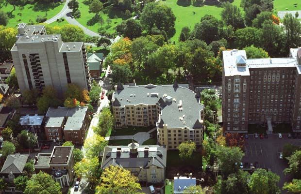
in Longueuil (see below).
Planning programme
It goes without saying that planning at the regional or agglomeration level is
complemented by the local municipality’s planning programme, all the more so as the
boundaries of a number of municipalities now encompass most or all of the urban
agglomeration. Mention should be made of the Ville de Drummondville (see page 24),
which, among other things, has adopted a commercial planning and development
policy as well as innovative means to encourage its implementation.
CASE STUDY Longueuil: Consolidation of urbanization through the
development of the area along boulevard Taschereau
When it reviewed its land use planning and development plan, the
former Champlain RCM engaged in a specific planning exercise
focusing on the development of boulevard Taschereau, one of the main
urban thoroughfares on the South Shore of Montréal. The plan aims
explicitly at fostering the increase and diversification of urban
functions, the development of infrastructure for a wide range of
transportation modes, and more extensive use of public transit.
The implementation of this plan will undoubtedly enhance access,
reduce the number of trips and encourage less polluting travel between
places of residence and places of consumption, workplaces or places
of entertainment.
21 Reduction of Greenhouse Gas Emissions and Land Use PlanningBoulevard Taschereau
and the economic and
service nodes identified in
the land use planning and
development plan.
Provisions in the land use planning and development plan
The revised land use planning and development plan fosters the
diversification of uses in the vicinity of this commercial thoroughfare,
by an increase in residential and office functions.
This approach is intended, on the one hand, to develop an active living
environment throughout the week and, on the other hand, to help
attract new public transit users, while creating a mixed, enriched urban
environment. The plan calls for the implementation of “integrated
projects” replacing now overabundant parking lots.
Moreover, the plan also makes provision for the redevelopment of the
boulevard’s public right-of-way to allow for the integration of various
modes of transportation, while ensuring the safety and smooth flow of
traffic and enhancing the quality of the physical environment.
In addition to the three traffic lanes in each direction, a reserved public
transit lane is planned, initially for buses and, ultimately, for a light-rail
train system, along with safe, comfortable facilities for pedestrians, i.e.
sidewalks with landscaped strips and crossings with shelters at
intersections. Cyclists would be channelled to a network of parallel
streets.
Reduction of Greenhouse Gas Emissions and Land Use Planning 22Implementation measures
To ensure the implementation of this comprehensive programme, the
revised land use planning and development plan has defined a number
of measures to be considered in the planning programme and by-laws,
and in development. Among the measures included are:
> review of municipal by-laws governing the construction and
architectural integration of buildings in order to enhance the
boulevard’s surroundings and improve its image (drawing buildings
closer to the road, increasing the minimum number of storeys,
harmonizing commercial displays and improving the functionality of
parking lots);
> development of public land to improve the interface with the private
domain, which includes, in particular, the provision of landscaped
strips, sidewalks and street furniture;
> detailed complementary studies such as development and design
plans for each economic and service node located along the
boulevard; such studies must emphasize the diversity of urban
functions and define the conditions under which such functions
coexist harmoniously.
Several priority initiatives have already been carried out in conjunction
with this planning exercise, such as: the addition of reserved bus lanes
on the shoulders, new intersections with traffic lights and safe
pedestrian crosswalks at busy intersections, along with the
reconfiguration of the Taschereau-Autoroute 10 interchange.
It should also be noted that improvements have been made to several
existing malls (renovation of the façades and landscaping) and new
commercial buildings have been erected. Furthermore, by-laws
governing site planning and architectural integration programmes
(SPAIPs) and the special planning programmes (SPP) have been
adopted in accordance with the development objectives.
Source : Ville de Longueuil
23 Reduction of Greenhouse Gas Emissions and Land Use PlanningCASE STUDY Drummondville: Planning and development of
commercial spaces
To reduce travelling distances and encourage the use of transportation
means other than the automobile, it is important to plan for different
types of business and service concentrations based on the market area:
> concentration of basic or daily businesses and services nearer to the
homes served, in the centre of districts or neighbourhoods;
> concentration of specialized businesses and services serving a wider
clientele, such as the entire urban agglomeration, in areas accessible
by various modes of transportation.
Business and service nodes in the 1996 planning programme
The Ville de Drummondville carried out this planning process when it
undertook its planning programme in 1996. While it recognizes the
importance of the commercial centre located at the periphery of the
urbanized area, the planning programme seeks to consolidate the city
centre and defines in respect of other sectors of the city “urban cells”
that are intended to become more autonomous with regard to the
presence of neighbourhood or local businesses and services.
In the planning programme, business and service nodes are delimited
in the city centre and in each of the urban cells. To foster the vitality of
each node, the zoning by-law defines an array of uses for businesses
and services corresponding in relation to the size of the market area.
Control over uses in the zoning by-law is also intended to prevent the
spreading of commercial zones beyond these nodes.
At the same time, when any external request is received to alter the
boundaries of a commercial zone or the nature of the uses authorized
therein, the city reassesses the balance between this zone and the
market area served. Depending on the findings of the study and the
zone’s commercial vitality, this may lead to a reduction in the perimeter
of the zone under study or of the range of uses permitted for the benefit
of zones that the city wants to strengthen.
Reduction of Greenhouse Gas Emissions and Land Use Planning 24Role of the Commercial Board (“Commissariat au commerce”)
In 1998, in conjunction with this ongoing planning exercise, the city
decided to be proactive with respect to the development of business
and service activities by establishing a special board.
In addition to the promotion of commercial activities and the sound
management of commercial lots and buildings, the board is also
responsible for the revitalization of the downtown area (“Corporation
Rues Principales Drummondville”).
Furthermore, it participates in the development process by submitting
recommendations to the urban planning advisory committee on all
questions related to commercial development, in respect of initiatives
related to the special planning programme and projects subject to the
site planning and architectural integration programme (SPAIP) by-law
which applies to the most strategic commercial sectors.
A mixed residential
and commercial building.
Photo : Mathieu Langlois
Source : Ville de Drummondville
25 Reduction of Greenhouse Gas Emissions and Land Use Planning2.1.2 Consolidate and revitalize city centres
and central neighbourhoods
Density and diversity promote fewer, less polluting trips.
Strategy
Traditional city centres and central neighbourhoods usually display a greater land use
density and diversity of functions and uses. Transportation infrastructure is designed to
allow for different modes of transportation.
These sectors should, ex ante, generate fewer and shorter “residence-workplace-
consumption-recreation-education and other service” trips than peripheral areas, which
are more spread out and where functions are more segregated. They also offer more
opportunities for travel by public transit, on foot or by bicycle.
Moreover, the concentration of activities found in these areas usually leads to the
convergence of public transit routes, which makes it possible to reduce automobile trips
from the periphery. Consolidation, increased density, redevelopment or revitalization of
city centres and older neighbourhoods, is a strategy that warrants consideration in order
to curb greenhouse gas emissions.
Focusing on the revitalization of city centres and central neighbourhoods
This strategy can benefit from a number of opportunities. There is throughout North
America a persistent trend to revitalize and repopulate city centres.9 This trend is
manifest, more specifically, by the development of new residential offerings, of
commercial and entertainment facilities, and by the sustained demand for office space.
9 Pierre Blais (2000). Aperçu de tendances émergentes en matière d’urbanisation dans les grandes agglomérations américaines
— revue de littérature. Québec: ministère des Affaires municipales, du Sport et du Loisir, Observatoire municipal, April,
20 pages (http://www.mamr.gouv.qc.ca/publications/obse_muni/tendances_emergentes.pdf
Reduction of Greenhouse Gas Emissions and Land Use Planning 26Increasingly, the city centre cores are becoming living environments, with an all day use rather than a single purpose time-limited daily use. This trend reflects the desire of a growing numbers of residents to live where they can walk to work and gain ready access to cultural and entertainment facilities. While they are less intensive areas, many central neighbourhoods located near the city centre core are also being revitalized. Many new housing units are located in former warehouses, commercial buildings or office buildings. Aside from the opportunities that they afford to recycle existing buildings, city centres and central neighbourhoods offer many potential sites for redevelopment, such as abandoned industrial lots or obsolete buildings that can be replaced. Moreover, there are still large institutional properties that can be subjected to more intensive use. Challenges to be met The consolidation and revitalization of city centres and central neighbourhoods also pose a number of challenges. Despite the diversity of functions and uses that makes many central areas attractive, the need for certain consumer goods and services gives rise to automobile trips to businesses that are often located in the periphery. The same is true of workplaces that are not always well served by public transit from central areas. Maintaining or recreating the greatest possible diversity of functions and uses, especially businesses, services and education, is a challenge for the consolidation of central areas. Attracting new residents to central areas where they are likely to find more services nearby, demands considerable effort to control and enhance the quality of the built environment, which is often denser and in which residents live and move about, often on foot. Special attention must be paid to the quality of housing (intimacy, amount of sunshine or the presence of private outdoor spaces), the architectural appearance of buildings, and the quality of street furniture. 27 Reduction of Greenhouse Gas Emissions and Land Use Planning
Diversified city centres.

                                                                                                                             Photo : Ville de Québec
                                         Means of action
                            Some land use and urban planning tools warrant consideration to implement this
                            strategy.

                            Planning and regulations
                            Planning tools such as the planning programme, the special planning programme (SPP)
                            or, the criteria included in by-laws concerning comprehensive development
                            programmes (CDPs), should include explicit development objectives in relation to the
                            consolidation and revitalization strategy while taking into account specific municipal
                            traits.
                            These development objectives should, among other things, address the following issues:
                            respect for the urban fabric and scale; development of efficient pedestrian or cycling
                            routes in light of the distribution of activity nodes and public transit routes; provision for
                            a sufficient number of neighbourhood services or a balance between a lively site-use
                            and residents’ need for peacefulness and privacy.
                            Such development objectives are usually reflected in the standards included in zoning,
                            subdivision and construction by-laws.

                                Reduction of Greenhouse Gas Emissions and Land Use Planning   28
On the other hand, in order to better take into account the diversity of the built environment in city centres and central neighbourhoods, these objectives can also be transposed as development criteria in discretionary urban by-laws which allow for the identification of requirements on a case-by-case basis such as site planning and architectural integration programmes (SPAIP), conditional use by-laws and by-laws concerning specific construction, alteration or occupancy proposals for an immovable (SCAOPI). Measures to support revitalization Financing tools and land assembly are highly useful to municipalities considering the complexity and cost of revitalization or redevelopment projects in city centres and central neighbourhoods. While in the short term, these measures require an investment by the municipality to support owners and developers, these prove highly profitable in the medium and long term. The programme to purchase buildings in the city centre and land banks for housing, are some of the measures which allow for the purchase of land or buildings and for improvements to be made to these by municipalities in order to make the properties more attractive to the developers who will buy them and carry out the desired revitalization project. Other measures to be considered include financial assistance measures either in the form of property tax credits or grants. Other measures also include, in Québec: specific contributions by a developer as determined under the provisions of a municipal works agreements by-law; a requirement to submit a preliminary programme for the redevelopment of a property subsequent to a demolition; the requirement that the developer pay for the cost of facilities under an SPAIP, a CDP or a SCAOPI; the requirement that the developer pay a contribution for parks, playgrounds and natural areas. In addition to allowing municipal funding of certain projects, these measures bolster regulatory provisions aimed at facilitating the provision of housing for different types of clientele, the establishment of local businesses or services or the implementation of pedestrian and cycling facilities and infrastructure, all of which can reduce the number of trips and distances travelled and encourage the use of alternative transportation modes instead of the automobile. 29 Reduction of Greenhouse Gas Emissions and Land Use Planning
Revitalization actions by municipalities
In conclusion, bearing the same objective, mention should be made that municipalities
may also act directly to provide for housing and the development of public spaces and
roads.
To demonstrate the feasibility of the strategies described in the preceding sections and
to illustrate how these were implemented, revitalization projects in Québec (see below),
Montréal (see page 32), Gatineau (see page 35), and Trois-Rivières (see page 38) are
examined.

CASE STUDY            Québec: Revival of the Saint-Roch area, the Lower Town
                      business centre
                  In the late 1990s, following several decades of decline, the Saint-Roch
                  area experienced a veritable rebirth. The revitalization includes the
                  development and consolidation of residential, commercial, service,
                  administrative, cultural and entertainment functions. The sector has
                  become a living environment in which trips can be reduced. Moreover,
                  because it is central, all of the new activities that have been established
                  there are readily accessible by means of public transportation. The
                  sector is also readily accessible by bicycle or on foot from other central
                  districts in the city.

                  Municipal public projects

                  In concrete terms, the revitalization of the area began with a series of
                  municipal public projects such as the development of the Jardin Saint-
                  Roch, the rehabilitation of rue Saint-Joseph, the establishment of city
                  administrative offices in heritage industrial buildings, the naturalization
                  of the banks of the rivière Saint-Charles, and the development of the
                  coteau Sainte-Geneviève.
                  Many buildings have been erected or recycled as dwellings, educa-
                  tional or research institutions, administrative offices, entertainment
                  centres and artists’ workshops. Between 1991 and 2001, over 100
                  buildings were restored, 800 new housing units were added, and
                  nearly 4,000 jobs were created or relocated in the district.

   Reduction of Greenhouse Gas Emissions and Land Use Planning   30
Saint-Roch area: a variety
of functions and uses in
the downtown core area.
Photo : Ville de Québec
A vast array of measures
The area’s redevelopment reflects a trend in North America to revitalize
and repopulate city centres. Governments usually support such
redevelopment. In Saint-Roch, the scope and speed of the revitalization
is largely attributable to governments and, in particular, the Ville de
Québec. The Québec case is also noteworthy because the city chose to
favour local initiatives, maintain residents and implement measures to
support precarious or underprivileged clienteles. To this end, the city
relied on a vast array of measures. Specifically, it:
> purchased buildings and funded the restoration of buildings which it
co-owned;
> set up a home ownership and renovation programme aimed at
artists’ workshops in order to consolidate these facilities which were
threatened by rising building values;
> offered financial assistance and other assistance for priority real
estate initiatives involving projects faced with special constraints such
as high building recycling and upgrading costs;
> put in place a policy to support businesspeople and implemented a
commercial building façade renovation programme on rue Saint-
Joseph;
31 Reduction of Greenhouse Gas Emissions and Land Use Planning> adopted a public consultation policy and reviewed the urban
planning by-laws to support and guide the district’s redevelopment.
This review included, among other things:
· an increase in density obtained by imposing a minimum
number of storeys;
· new standards governing soundproofing and ventilation as
well as the prohibition for restaurants and bars to play music
outdoors to ensure the harmonious integration of projects into
the surrounding area;
· an adjustment of building occupancy standards to allow for
more lively street-level activities and for a mix of residential
and commercial uses;
· provision for the use of the “plans de construction“
technique, similar to the specific construction, alteration or
occupancy proposals for an immovable as provided for under
the Act respecting land use planning and development, to
manage the insertion of new buildings into densely built
environments;
· restrictions of the area occupied and the distance between
certain uses, in order to foster a sound distribution of
functions: for example, bars and activities related to
entertainment must be separated by a minimum distance,
which varies by zone.
Source : Ville de Québec
CASE STUDY Montréal: The Angus project and the redevelopment of
a run-down industrial site
The Angus project, now underway in the Rosemont district in Montréal,
is located on the former site of the Canadian Pacific Angus Shops. It
encompasses a diversified array of urban functions, i.e. medium-
density residential buildings, including townhouses, condominiums
and rental duplexes and triplexes, a food store set up in a former
industrial building, a number of other neighbourhood businesses and
the Technopôle Angus, an industrial park managed by a community-
based organization, the Société de développement Angus.
Reduction of Greenhouse Gas Emissions and Land Use Planning 32The project is well integrated into the surrounding urban fabric and is
contributing to the diversity, a common trait of central neighbourhoods
where improved access leads to reduced and less polluting trips
between places of residence, work and consumption. In particular, it
offers new industrial locations in an area that is not solely accessible by
automobile which is the case in the suburbs.
In 1995, project planning by Canadian Pacific, owner of the property,
and the Ville de Montréal, produced a development programme similar
to a comprehensive development programme (CDP), which defines the
allowable uses and densities.
In addition to this programme, a development agreement was signed
governing all questions relating to implementation. Consideration was
given to the concerns of residents of the neighbouring Rosemont-Petite-
Patrie district, which led, in particular, to the designation of an
industrial zone to be included in the redevelopment. Redevelopment
began in 1998 with decontamination of the site funded by the
government’s Revi-sol programme.
Urban design principles
The project adheres to the urban design objectives and principles
included in the development programme, such as:
> a grid of perpendicular streets that extends neighbouring streets,
which facilitates travel and contributes to the project’s integration
into the neighbourhood;
> a series of small squares surrounded by residential buildings;
> the preservation of heritage, such as the walls of old buildings and
machine-made parts, that are reminders of the area’s industrial past.
33 Reduction of Greenhouse Gas Emissions and Land Use PlanningThe grid of perpendicular
streets extends
neighbouring streets, thus
facilitating travel
A group of townhouses
seen from one of
the squares.
Photo : Mathieu Langlois
Source : Ville de Montréal
Reduction of Greenhouse Gas Emissions and Land Use Planning 34CASE STUDY Gatineau: Residential revival on the Île de Hull
The Île de Hull includes the traditional downtown area of the former
Ville de Hull, now part of Ville de Gatineau. Beginning in the 1970s,
many real estate projects were developed in the downtown area, in
particular office buildings. Today, nearly 25,000 jobs, mostly in the
public sector, are located in this area.
Specific action programme
The revitalization of the Île de Hull, initiated in the 1990s, focused at
the outset on the consolidation of the downtown commercial areas. In
2000, the city broadened its revitalization perspective by adopting a
specific programme centred on residential development.
This initiative, aimed, in particular, at increasing density, should help to
reduce automobile trips, since a greater numbers of residents will
benefit from this central location in the urban agglomeration. This
greater density is also likely to draw closer together places of residence
and the already numerous workplaces in the area.
A demolition monitoring committee was set up to study redevelopment
proposals, and ensure that new projects are sound. This measure is
seen as facilitating the administration of the specific action programme
bearing in mind that the Île de Hull has been particularly hard-hit by
the major urban renovation initiatives of the past 40 years.
35 Reduction of Greenhouse Gas Emissions and Land Use PlanningYou can also read