Two Year Progress Report - on the Dún Laoghaire-Rathdown County Development Plan 2016-2022 - Two Year progress ...
←
→
Page content transcription
If your browser does not render page correctly, please read the page content below
Two Year Progress Report
                                        on the
                       Dún Laoghaire-Rathdown
                      County Development Plan
                                    2016-2022

April 2018

Planning Department
CDP 2016-2022: 2 Year Progress Report

Table of Contents

1   Introduction ............................................................................................................................................................ 3
2   Strategic Overview ................................................................................................................................................ 11
3   Sustainable Communities Strategy........................................................................................................................ 18
4   Enterprise and Employment Strategy ....................................................................................................................29
5   Green County Strategy .......................................................................................................................................... 37
6   Physical Infrastructure Strategy .............................................................................................................................42
7   Built Heritage Strategy .......................................................................................................................................... 47
8   Community Strategy .............................................................................................................................................49
9   Principles of Development ..................................................................................................................................... 52

                                                                                                                                                                             2
DLR Planning Department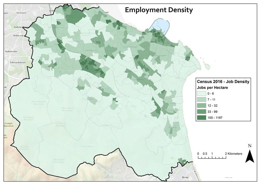
CDP 2016-2022: 2 Year Progress Report

                                                            increased by c. 174,000 persons since 2011. This
1 Introduction                                              represents a change of 3.8% over the 5 year inter-
                                                            censal period. The results of the Census highlight a
The Dún Laoghaire-Rathdown County Development
                                                            trend towards an overall ageing population with the
Plan 2016-2022 (CDP 2016) was adopted by the Elected
                                                            average age nationally increasing from 36.1 years in
Members at a Special Meeting of the Council held on
                                                            2011 to 37.4 years in 2016.
17th February 2016, following a two year long review of
the 2010-2016 CDP, and the Plan came into effect on         Dublin’s population increased from 1.27m to 1.35m, an
the 16th March 2016. Section 15 (2) of the Planning and     increase of c. 74,000 persons (5.8%) while the
Development Act, 2000, states that ‘…a Planning             population of Dún Laoghaire-Rathdown grew by c.
Authority shall, not more than 2 years after the making     11,800 persons or 5.7%. The population of the County
of a Development Plan, give a report to the Members of      now stands at c. 218,000. The 2011-2016 population
the Authority on the progress achieved in securing the      growth rate for Dún Laoghaire-Rathdown was the
objectives’ of the Plan.                                    second highest growth rate of the four Dublin Local
                                                            Authorities; with only Fingal County Council recording
In the two years since the making of the CDP in 2016
                                                            a higher growth rate at 8% (South Dublin County
the County has experienced considerable growth and
                                                            Council and Dublin City Council were both c. 5.1%
development and significant progress has been made
                                                            respectively). This overall rate of population growth in
towards the implementation of the policy objectives of
                                                            Dún Laoghaire-Rathdown is a continuation of the trend
the Plan. This Report is structured to examine each
                                                            experienced in the previous 2006-2011 inter-censal
Chapter of the CDP 2016, selecting a number of the key
                                                            period that recorded an increase of c. 12,000 persons
policy objectives from each, and providing a
                                                            (6.3% growth). This pattern of demographic growth
commentary on the progress achieved since the
                                                            demonstrates that the residential development policies
adoption of the Plan. In advance of the main body of
                                                            pursued by the Planning Authority in recent years are
the Progress Report, this introductory Section will
                                                            succeeding in achieving a sustainable level of growth of
provide a contextual overview of some of the broader
                                                            the County.
changes - both national and local - that have occurred
since the adoption of the CDP 2016.                         At a local level, the ED of Glencullen recorded the
                                                            highest growth with an additional 2,362 persons or
1.1    2016 Census Results                                  13.6%. This was followed by the Dún Laoghaire-
                                                            Sallynoggin West ED that increased by 986 persons or
The objectives of the CDP 2016 were largely framed          52.3% primarily as a result of development at the
within the context of the 2011 Census results. Census       former Dún Laoghaire Golf Club lands (this ED recorded
2016 was subsequently undertaken in April 2016 and          a decline in population growth over the 2006-2011
the results from same are now available. In the National    intercensal period). The ED’s of Dundrum-Balally (965
context, the total number of people living in Ireland has   persons) and Dundrum Sandyford (700 persons) also

Figure 1: Percentage Population Growth 2011-2016            Figure 2: Population Decline to Growth
                                                                                                                   3
DLR Planning Department
CDP 2016-2022: 2 Year Progress Report
recorded significant growth. In terms of areas in decline the Dún Laoghaire-Rathdown area that includes inter
the Foxrock-Carrickmines ED experienced the greatest alia the following:
decline in the County with a loss of 138 persons over the
5 year period. Overall, the Census results indicate a Metro Link.
continuing reversal of the historic trend of population LUAS Network Expansion to Bray.
decline in the County. Encouragingly, the results DART Expansion Programme.
indicate the intensification of growth in areas Dublin BusConnects.
proximate to employment centres and areas well National Rehabilitation Hospital (Phase 1 & 2).
served by public transport such as the LUAS.
(iii) Regional Spatial and Economic Strategy (RSES)
1.2 Planning Policy and Legislative The principal statutory purpose of the forthcoming
Changes RSES is to support the implementation of the NPF. The
RSES will set out a long-term spatial planning and
There have been a number of significant developments economic framework for the Eastern and Midland
in National and Regional policy since the adoption of Region in accordance with the economic policies of the
the CDP 2016. An overview of the more pertinent Government and the proper planning and sustainable
statutory provisions is set out below. development of the County for a period of 12 to 20
years. In practical terms the RSES will take the high-
(i) National Planning Framework (NPF) level framework and principles set out in the NPF and
apply a finer level of detail at Regional and Local
The NPF was published in February 2018 and sets out Authority levels.
the Government’s high-level strategic plan for shaping
the future growth and development of Ireland to the The Eastern and Midlands Regional Assembly (EMRA)
year 2040. The NPF has replaced the National Spatial carried out an initial pre-draft consultation phase from
Strategy (NSS) and now represents the overarching November 2017 to February 2018. EMRA now intends
National planning policy document, of direct relevance publishing a Draft RSES in Q2 2018 and this Draft will
to the planning functions of Regional and Local be placed on public display for at least 10 weeks.
Planning Authorities. Importantly, the Planning and Following consideration of submissions the Regional
Development (Amendment) Bill 2016 provides a Assembly will consider material amendments as
statutory footing and legislative basis for the NPF and appropriate. Subsequent to any material amendments,
furthermore includes a monitoring process in relation and associated consultation periods, EMRA will adopt
to its implementation and a statutory requirement for and publish a RSES for the Eastern and Midland
regular reviews and updates. Region. It is currently anticipated that this will take
place in Q1 2019. The stages in the RSES process are
illustrated in Figure 3 below. Importantly, once the
RSES is adopted, Dún Laoghaire-Rathdown will be
obliged to review the CDP 2016 and consider whether
any variations are required in order to align with the
objectives of the RSES.
(ii) National Development Plan 2018-2027 (NDP)
The NDP was also published in February 2018 and sets
out the investment priorities that will underpin the
implementation of the NPF. The NDP will guide
National, Regional and Local planning and investment
decisions in Ireland over the next two decades. The Figure 3: Stages in the RSES Process
NDP includes a number of significant investments for
4
DLR Planning Department
CDP 2016-2022: 2 Year Progress Report
(iv) Metropolitan Area Strategic Plan for Dublin (vi) Sustainable Urban Housing: Design Standards
(MASP) for New Apartments – Guidelines for Planning
Authorities (March 2018)
National Policy Objective 67 of the NPF states:
These new Guidelines update the earlier ‘Sustainable
“Provision will be made for Metropolitan Area Urban Housing: Design Standards for New Apartments’,
Strategic Plans to be prepared for the Dublin, Cork, published in 2015. They take account of up-to-date
Limerick, Galway and Waterford Metropolitan areas evidence of projected future housing demand, the
and in the case of Dublin and Cork, to also address overall policy context of Rebuilding Ireland and the
the wider city region, by the appropriate authorities in NPF, as well as circumstances and trends prevailing in
tandem with and as part of the relevant Regional the housing market. The focus of the Guidelines is on
Spatial and Economic Strategies.” the planning-related aspects of apartment building and
individual units including specific apartment design
In tandem with, and as part of the RSES process, the parameters. In addition, the Guidelines now address
NPF provides for the preparation of a MASP for Dublin. apartments in the ‘build to rent’ and ‘shared
The MASP for Dublin will be provided with statutory accommodation’ sectors.
underpinning to act as 12-year strategic planning and
investment frameworks for the city metropolitan area, The Guidelines contain a number of ‘Specific Planning
addressing high-level and long-term strategic Policy Requirements’ (SPPRs) that take precedence over
development issues including: any conflicting policies and objectives of the CDP and
Local Area Plans. It is intended that a Report on these
Physical development patterns and strategic new Guidelines will be brought as a headed item to the
growth areas. May Council meeting.
Large scale regeneration and the spatial
location of housing and employment. (vii) Transport Strategy for the Greater Dublin Area
Strategic infrastructure including 2016-2035
transportation and water services. The Transport Strategy for the Greater Dublin Area
Metropolitan-scale amenities. 2016-2035 provides a framework for the planning and
delivery of transport infrastructure and services in the
The MASP for Dublin will be prepared in tandem with Greater Dublin Area over a period of two decades. The
and as part of the plan making process for the RSES, Strategy was approved in April 2016, very shortly after
which is a reserved function of the elected members of the adoption of the CDP 2016.
the Regional Assembly.
(v) Rebuilding Ireland, an Action Plan for Housing 1.3 Economic Performance and
and Homelessness Commercial Development Trends
Rebuilding Ireland was published in July 2016 and
focusses on tackling Ireland’s housing shortage. The This 2 Year Progress Report is framed in the context of
Action Plan takes a multi-faceted approach to dealing a much improved National ‘picture’ with the economy
with the housing crisis by way of five pillars that continuing to normalise following a prolonged period of
broadly incorporate the following: addressing contraction and instability. The medium-term outlook
homelessness; accelerating social housing; building for Ireland suggests that the economy is likely to
more homes; improving the rental sector; and utilising continue to grow, albeit subject to potential external
existing housing. shock factors, and that this economic growth will be
accompanied by substantial population growth. While
the economic indicators are positive it is noted that
there remains an evident deficit in infrastructure
following the financial downturn, most notably in the
area of housing, and this remains a key constraint in the
delivery of additional growth.
At County level, the key economic indicators suggest a
much improved local economy with more jobs and
fewer people unemployed. Analysis of Census 2016
data indicates that there was on average over 1,500
jobs created within the County each year over the 5
year inter-censal period, representing an increase of
5
DLR Planning Department
CDP 2016-2022: 2 Year Progress Report

7,790 jobs from 2011 to 2016. In tandem with an            approximately 9,500 units were constructed in the
increase in jobs there has been a consistent decline in    County, leaving an allocation of c.30,800 for the
the number of person’s unemployed in the County.           remaining years. In annualised terms, this allocation
                                                           translates to approximately 3,800 units per annum over
Central to the growth of the National economy has          this period.
been Ireland’s continued success in attracting multi-
nationals and foreign direct investment (FDI). Dún         Figures derived from the ESB Connections data for Dún
Laoghaire-Rathdown plays an important role in this         Laoghaire-Rathdown from 2010 to 2017 indicate a total
area with a highly educated and skilled labour force,      output of approximately c.5,000 residential units in
and a high number of persons employed in                   seven years (see Table 1 below).
professional, managerial and technical services. The
Sandyford Business District (SBD) is a designated          House completions in the County peaked at an all-time
SMART Region and a national leader in this regard with     high in 2007 with 3,050 units built in that year alone.
c. 1,000 companies and a highly-skilled workforce of       The Council’s policies of encouraging densification in
approximately 25,000 persons. The occupation by            existing built-up areas and facilitating quality, higher
Microsoft of its 34,ooo sq.m new HQ building at South      density new development areas, such as Stepaside,
County Business Park and the leasing of Block H at         contributed significantly to this increased rate of
Central Park to AIB comprised notably large office         supply.
transactions in 2017. The Council recognises the
important role of the SBD in the County and continues            Housing Completions in DLR since 2010
to support its growth as evidenced by its continued
development since the adoption of the CDP 2016.                  2010                           384

In line with much improved economic circumstances                2011                           192
the overall commercial sector has experienced
continual expansion through 2016 and 2017, and this              2012                           175
trend is expected to continue in the short-to-medium
term. The delivery of commercial led planning schemes            2013                           260
at key locations in the County including Cherrywood,
Blackrock and Stillorgan indicates an increasingly               2014                           713
strong private sector appetite for development. This is
in stark contrast to that experienced over the previous          2015                           651
CDP period of 2010 to 2016 when commercial property
development effectively stalled. The improvement in              2016                           1,179
the commercial sector is also evidenced in the ongoing
reduction in commercial vacancy rates of existing                2017                           1,388
stock. At the end of Q4 2017, the headline vacancy rate
for Dublin offices was 6.1% in contrast to an overall                   Table 1: Total ESB Connections Data
vacancy rate of 7.7% in Q1 2016.
                                                           The collapse of the property market in 2008 had a
                                                           profound effect on the delivery of housing in Dún
1.4    Housing Supply and Delivery                         Laoghaire-Rathdown, particularly from 2010 to 2013.
                                                           This was reflected throughout the Dublin Region and,
Dún Laoghaire-Rathdown County covers an area of            indeed, the wider State. The first signs of recovery were
only c.12,000 hectares. Spatially, Dún Laoghaire-          evident in 2014-2015 with 713 and 651 housing
Rathdown is by far the smallest County in the State and    completions respectively. The figures for 2016 and 2017
represents only 12% of the land mass of the Dublin         are extremely positive showing an upward trend in
Region. Approximately half the County could be             terms of construction activity within the County. The
described as urban (or suburban) and half described as     total number of ESB connections in Dún Laoghaire-
rural. The Regional Planning Guidelines 2010-2022          Rathdown for 2016 and 2017 is c.2,600.
forecast that the population in Dún Laoghaire-
Rathdown would grow to 240,000 by 2022 based on            By the end of 2017, there were c.1,400 residential units
the Census 2006 data. Based on this projection the         under construction in the County on 37 ‘Active Sites’.
RPG’s set a target for Dun Laoghaire-Rathdown to           There are a further c.3,600 residential units with
maintain 16% of the population in the Dublin Region.       planning permission which have not commenced
This equated to a housing allocation of c.40,000 for the   development on site. There are an additional c.3,600
years 2006 to 2022. Between 2006 and 2013,                 residential units in the planning system that are

                                                                                                                  6
DLR Planning Department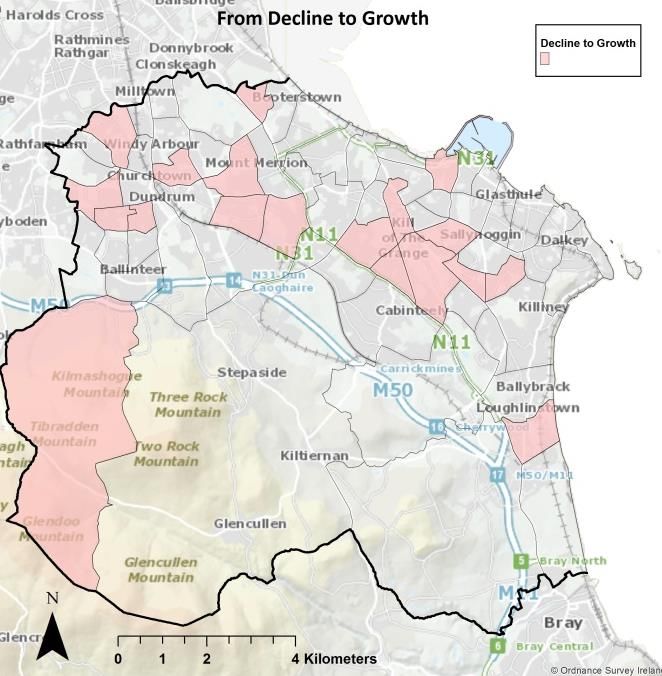
CDP 2016-2022: 2 Year Progress Report
% of
% of % of
% of Residential
Residential % of Residential
Dublin Residential Units within % of
Units Residential Units
Authorities - Units with the planning Active
permitted Units under completed in
Q4 2017 Data planning system - Sites
but not construction completed
permission awaiting final
commenced developments
determination
Dublin City 24% 27% 27% 36% 22% 13%
DLR 18% 36% 16% 19% 21% 14%
South Dublin 12% 14% 11% 15% 16% 73%
Fingal 46% 23% 47% 30% 41% 0%
Total (Figure) 37164 9909 22295 7316 174 570
Table 2: Dublin Region HTF Returns – Q4 2017
awaiting final determination by the Planning Authority Table 3 opposite contains details of the significant
or An Bord Pleanála. 50% of the planning applications housing developments (100+ Units) with planning
awaiting a final decision are with An Bord Pleanála. permission in Q4 2017.
Within the Dublin Region, 36% of all residential units in Table 4 below contains details of significant residential
the planning system by Q4 2017 were located within developments (100+ Units) currently in the planning
Dún Laoghaire-Rathdown (see Table 2 above). system (Q4 2017) which are awaiting final
determination.
No. of No.
Site Name Status Units of
Site Address Units Status
Belarmine Completed Q2 2017 126
On appeal (with
The Grange Completed Q1 2017 510 respect to
Central Park Completed Q4 2016 166 Development
Contributions
Hazelbrook Completed Q3 2017 97 Beech Park, Cabinteely 153 only)
Culanor Under construction 1018 Site at Annaghkeen & Dalwhinnie,
Honeypark Under construction 919 Leopardstown Road, St Joseph's House
(Protected Structure) & Marian Villa,
Trimbleston Under construction 202 Brewery Road, Stillorgan 139 On appeal
Belmont Under construction 101 Lands in the townlands of Lehaunstown
Belmont Not commenced 243 and Cherrywood (Domville site) - SDZ 322 On FI
Lands in the townlands of Cherrywood,
Elmfield Under construction 209 Laughanstown, Brennanstown,
Brighton Wood Under construction 100 Loughlinstown and Glebe - SDZ 1269 On FI
Ashwood Farm Under construction 139 Site at Knockrabo, Mount Anville Road,
Goatstown 91 Just lodged
Fernbank Under construction 269
Total 1974
Notre Dames Not commenced 273 Table 4: Significant Residential Developments (100+ Units) in the
Herbert Hill Under construction 91 planning system (Q4 2017)
Clay Farm Under construction 410
Former Avid Site Not commenced 147 A number of significant Government enabling actions
Greenacres Not commenced 120 have been introduced to expedite the delivery of
Knockrabo Under construction 75 housing within the Dublin region and nationally. They
Bray Golf Club Lands Not commenced 348 include:
Barrington’s Tower Not commenced 158
Dublin Housing Task Force (HTF).
Total 5721 Vacant Site Register.
Table 3: Significant Housing Developments (100+ Units) with
Major Urban Housing Developments (MUHDS)
planning permission (Q4 2017)
Programme.
7
DLR Planning Department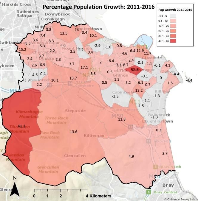
CDP 2016-2022: 2 Year Progress Report
Local Infrastructural Housing Activation Fund 1.4.2 MUHDS
(LIHAF).
Strategic Housing Development. In November 2016, the Government launched the
Change of Use Exemptions. MUHDS (Major Urban Housing Development Sites)
programme under Pillar 3 of ‘Rebuilding Ireland: An
These enabling actions are discussed in greater detail Action Plan for Housing and Homelessness’ (APHH). The
below. overall objective of the MUHDS Programme is to
facilitate the fast-track delivery of up to 30,000 housing
units over a 3-4 year period in major urban centres in
1.4.1 Dublin Housing Task Force Returns Dublin, Cork, Galway and Limerick. The 23 key strategic
housing sites identified under MUHDS have the
The Dublin Housing Task Force Returns show a
capacity to quickly deliver a significant scale of new
significant increase in both planning and construction
homes, in conjunction with Local Authorities and other
activity within the Dublin region, including Dún
stakeholders. It was envisaged that many of these sites
Laoghaire-Rathdown, over the last two years. would be opened up through LIHAF funds, alternative
funding and coordination mechanisms.
The Dublin Housing Task Force (HTF) was initiated in
2014 - as an Action under ‘Construction 2020’ - with an
The Housing Delivery Office, established under the
immediate focus on (i) monitoring trends in the supply
Rebuilding Ireland’s APHH, was tasked with
of viable and market-ready approved developments,
establishing a programme approach to drive the
and (ii) seeking to ‘unblock’ constraints where supply is
implementation of these strategically significant sites
believed to be below what is required. The data utilised
in the main urban areas. The MUHDS sites identified in
within the HTF is limited to capturing developments
Dún Laoghaire-Rathdown are:
with planning permission for 10 or more units.
Kiltiernan-Glenamuck LAP
One of the objectives of the HTF Returns is to monitor
Cherrywood SDZ
the number of units completed relative to the
Woodbrook-Shanganagh LAP
residential development target set out in the Core
Strategy of each Dublin Authority. The HTF Returns
Two of the MUDHS sites identified - Cherrywood SDZ
require that the overall Core Strategy target figure be
and Woodbrook-Shanganagh LAP - in the County have
divided into three categories (Tier 2B):
been recommended to receive funding under the Local
Infrastructure Housing Activation Fund (LIHAF). The
Units on Serviced Land & Ready to be
types of infrastructure being provided under LIHAF
Developed;
include distributor roads, bridges and junctions.
Units Requiring Infrastructure & Investment;
and,
Number of Units Dependent on Irish Water 1.4.3 Strategic Housing Development
Investment.
In 2016, new planning legislation, ‘Planning and
Development (Housing) and Residential Tenancies Act
2016’, was introduced to allow planning applications for
Dublin Housing Task Force housing developments of more than 100 residential
units and/or 200 plus student bed spaces be made
directly to An Bord Pleanála under a new ‘fast-track’
4,400, Units on Serviced planning system. The associated regulations ‘Planning
13% Land & Ready to
and Development (Strategic Housing Development)
be Developed
Regulations 2017’, came in to effect in July 2017.
9,609, 19,591, Units Requiring
Infrastructure &
29% 58%
Investment
Number of Units
Dependent on Irish
Water Investment
Figure 4: Dublin HTF Returns - Tier 2B Subcategories (Q4 2017)
8
DLR Planning Department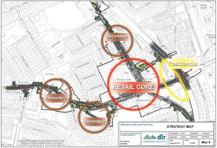
CDP 2016-2022: 2 Year Progress Report

                               No. of                              quantum of commercial floor space available as a
                            Residential                            consequence, will be monitored by the Council.
Site Location                  Units             Status
                             2,178 bed     Granted by An Bord
UCD, Belfield
                              spaces*           Pleanala
                                                                   1.4.5    Vacant Sites Register
                                           Refused by An Bord
                                            Pleanala / at pre-     The Urban Regeneration and Housing Act 2015 (URHA
Clay Farm, Ballyogan         927 units                             2015) introduced the vacant site levy as a site activation
                                          planning stage again
                                                currently          measure to ensure that vacant or underutilised land in
Former Blakes &             103 units +                            urban areas is brought into beneficial use. The primary
                                           Granted by An Bord      purpose of the legislation is to assist in addressing the
Esmonde Motors Site,         576 bed
                                                Pleanala
Stillorgan                   spaces*                               current housing supply shortage and to stimulate
Dun Laoghaire Area -                                               increased activity in the construction sector.
Blackrock, Dún Laoghaire     1360 units    Pre-planning Stage
and Killiney-Shankill                                              In accordance with the requirements of the URHA 2015,
Dundrum Area -             1712 units +                            Dún Laoghaire-Rathdown established a Vacant Site
                                                                                       st
Dundrum, Stillorgan and       600 bed    Pre-planning Stage        Register on the 1 January 2017. Subsequent to a
Glencullen-Sandyford          spaces*                              comprehensive assessment process the Local Authority
                           4,102 Units +                           has now placed 6 no. sites on the Vacant Sites Register.
                             3,354 bed                             In addition, a further tranche of sites have been
Total                          spaces                              identified and the purported landowners have been
*Student Accomodation                                              issued with initial Notices of intention in accordance
Table 5: Strategic Housing Developments (100+ Units) up to March   with Section 7(1) of the Act.
2018

                                                                   The identification of potential sites for inclusion on the
                                                                   Vacant Sites Register is an organic, continual process.
There has been a significant amount of planning
                                                                   The Planning Authority is committed to continuing to
activity in Dún Laoghaire-Rathdown under the new
                                                                   investigate additional potential sites for inclusion on
fast-track legislation. The first SHD planning
                                                                   the Vacant Sites Register on an ongoing basis in
application was for a large-scale student
                                                                   accordance with the provisions of the URHA 2015.
accommodation development at UCD. The second
SHD application processed by An Bord Pleanála was for
c.900 residential units at Clay Farm (Phase 2) in                  1.5     Infrastructure Delivery
Ballyogan. Table 5 above contains details of the
Strategic Housing Development sites in the planning                The delivery of a significant portion of critical
system up to March 2018.                                           infrastructure in the County is now inextricably linked
                                                                   with external agencies and central government funding
1.4.4     Exempt Development Regulations                           arrangements, in addition to the Capital Budget. While
                                                                   the Local Authority has a co-ordinating and supporting
In February 2018, three new sets of exempted                       role in this regard, the provision of major infrastructure
development regulations were introduced: ‘Planning                 to unlock the development potential of zoned lands will
and Development (Amendment) Regulations 2018’;                     ultimately be delivered in conjunction with other
‘Planning and Development (Amendment) (No. 2)                      agencies - in line with central government policy.
Regulations 2018’; and, ‘Planning and Development
(Amendment) (No. 3) Regulations 2018’. These new                   Since 2014, the Local Authority no longer has any direct
exemptions include for inter alia the change of use, and           control in relation to the provision of water or
any related works, relating to the conversion of vacant            wastewater services. The delivery of strategic water
commercial premises, including ‘over the shop’ type                and wastewater infrastructure is now the responsibility
premises for residential use.                                      of Irish Water. With regard to transportation, the Local
                                                                   Authority is now required to ensure that the CDP is
The main objectives of the new change of use                       consistent with the National Transport Agency’s (NTA)
exemptions are to facilitate the provision of increased            ‘Transport Strategy for the Greater Dublin Area 2016-
and much needed housing supply, to maximise the use                2035’. In this regard the Local Authority plays a dual
of vacant underutilised spaces and assist in the                   role by continuing to provide for the elements of
rejuvenation of inner-core urban areas. The impact of              infrastructure delivery that are within its own remit and
this new legislation on housing supply, and the                    also encouraging the development of other
                                                                   infrastructure projects delivered by external agencies,
                                                                   such as the NTA.

                                                                                                                           9
DLR Planning Department
CDP 2016-2022: 2 Year Progress Report
The Local Infrastructure Housing Activation Fund To develop the area between the East Pier
(LIHAF) is a key element of ‘Rebuilding Ireland: An and Sandycove, including the open space
Action Plan for Housing & Homelessness’. The fund is at Otranto Place. (SLO 21)
aimed at the provision of public off-site infrastructure The streetscape/public realm
to relieve critical infrastructure blockages and improvement at Monkstown. (SLO 106)
ultimately to increase the supply of housing. An initial To prepare and adopt a Masterplan to
call for proposals from Local Authorities under the develop Fernhill Gardens. (SLO 36)
LIHAF was issued in August 2016. As part of this call
initial approval was given for 34 no. public Other Council-generated SLO projects and plans of this
infrastructure projects across 15 Local Authority’s nature will be brought forward and advanced over the
nationwide. Of these, Dún Laoghaire-Rathdown is lifetime of the current CPD - having due regard to the
currently advancing 3 no. sites (see Table 6 below). As strictures of the recently approved Three Year Capital
part of the National Budget 2018, it was announced Programme.
that an additional €50 million of Exchequer funding
would be available for a second LIHAF call. It is (ii) The second ‘category’ of SLO generally
anticipated that this second call for proposals will commits the Council to support or promote
commence shortly. projects and schemes being advanced by, or in
conjunction with, third parties - either private
Detail of Infrastructure (€m) and/or public. Almost always the mechanism
for advancing both the overall project and
Cherrywood Road upgrades and bridge 15.19
delivering the SLO ‘imperatives’ attaching will
Clay Farm Loop distributor road 4.7 be through the Development Management
Woodbrook Distributor road and 4.16 process. Recent examples of this type include
Shanganagh junction upgrade the following:
Table 6: LIHAF Funding
To facilitate, support and enhance the
development of UCD… (SLO 1)
Under ‘Project Ireland 2040’ it is an objective of the NPF
To encourage the amalgamation of shop
to establish a National Regeneration and Development
units to allow for the creation of…larger
Agency. Under this Agency, a €3 billion regeneration
shop floor plates - particularly in the (Dún
and development fund will be put in place to drive and
Laoghaire) Town Centre Quarter. (SLO
support the aims of the NPF. This will be a competitive
128)
fund, whereby regional and local authorities and other
To facilitate the further development of
agencies will bid to leverage public investment. It is
the Sandyford Business District in
anticipated that further information regarding the
accordance with the policies and
functioning of this fund will be made available in the
objectives of the Sandyford Urban
near future.
Framework Plan. (SLO 120)
To implement and develop the lands at
1.6 Specific Local Objectives Cherrywood in accordance with the
approved SDZ Planning Scheme. (SLO 52)
In relation to Specific Local Objectives (SLO) these tend To encourage the redevelopment and
to fall into two ‘general’ categories: refurbishment of the former Killiney
Beach Tea Rooms…(SLO 132)
(i) The first would relate to the delivery or
promotion of specific tangible projects and/or The Development Management ‘arm’ of the Planning
plans over which the Council would have full Authority will continue to monitor SLO ‘tagged’
control. These are almost always brought projects being advanced by third parties to ensure the
before the Members under the provisions of objectives and imperatives set out in the SLO are
Part 8, Local Area Plan legislation etc - all of optimised.
which are Reserved Functions. Recent
examples of this type would include the
following:
The redevelopment of the former flats at
Rosemount Court. (SLO 92)
10
DLR Planning DepartmentCDP 2016-2022: 2 Year Progress Report
a comprehensive assessment on whether a Variation of
2 Strategic Overview the CDP 2016 will be required or whether a full review
of the Plan would be merited.
2.1 Strategic Framework
The Planning and Development Act 2000 (as amended)
requires that a CDP shall, so far as is practicable, be
consistent with National and Regional plans, policies
and strategies which relate to the proper planning and
sustainable development of the area. At a National
level the strategic planning framework has
fundamentally changed since the adoption of the CDP
2016. The recently published NPF replaces the National
Spatial Strategy and now represents the overarching
national planning policy of relevance to the planning
functions of the Local Authority.
The Planning Authority is required ‘to be consistent
with’ any Regional Planning Guidelines in force in its
area when making and adopting a CDP. In this regard,
the CDP 2016 was prepared to be consistent with the
‘Regional Planning Guidelines for the Greater Dublin
Area 2010-2022’. The Eastern and Midland Regional
Assembly is currently preparing a new Regional Spatial
and Economic Strategy (RSES) to replace the existing
Guidelines and it is anticipated that the process for
making the RSES will conclude in Q1 2019.
The objectives of the NPF will be applied on a regional
basis through the RSES. This will include developing
and agreeing a distribution of future population growth Figure 5: Planning Policy Framework
at a more detailed and regional level than the NPF, but
working broadly within the parameters of its
framework. The RSES must accord with the NPF and in 2.2 Core Strategy
turn, the Dún Laoghaire-Rathdown CDP must be in
accordance with the RSES (Figure 5 illustrates the new The Planning and Development (Amendment) Act 2010
spatial planning hierarchy in Ireland). introduced the requirement for an evidence-based Core
Strategy to be incorporated as part of all County
The ‘Retail Strategy for the Greater Dublin Area 2008- Development Plans. The purpose of the Core Strategy
2016’ is the strategic framework to help guide and is to articulate a medium-to-longer term quantitatively-
inform retail policy and objectives in the CDP. It is based strategy for the spatial development of the CDP,
anticipated that a full review of the existing retail and, in so doing, to demonstrate that the CDP and its
strategy will take place shortly after the adoption of the policies and objectives are consistent with National and
RSES. With regard to transport strategy at a Regional Regional development objectives.
level there is a statutory requirement for the RSES to
be consistent with the NTA’s ‘Transport Strategy for the The recently published NPF provides the blue print for
Greater Dublin Area 2016-2035’. Similarly, the NTA will the strengthening of the evidenced-based approach of
be obliged to review the Transport Strategy for the the Core Strategy. In this regard, National Policy
GDA subsequent to the adoption of the RSES. Objective 71 of the NPF sets out the following:
Overall, it is considered that the strategic framework, “City/County development plan core strategies will be
within which the current CDP operates, is further developed and standardised methodologies
fundamentally shifting from that which was in place at introduced to ensure a coordinated and balanced
the time its adoption in 2016. In this regard, following approach to future population and housing
the adoption of the RSES for the Eastern and Midlands requirements across urban and rural areas.”
Region, the Planning Authority is obliged to undertake
11
DLR Planning DepartmentCDP 2016-2022: 2 Year Progress Report
The NPF introduces a new standardised methodology growth of the Region over the next 12-20 years. In line
that will require Planning Authorities to differentiate with the RSES, a Metropolitan Area Strategic Plan will
between i) zoned land that is serviced, and ii) zoned also be provided with statutory underpinning to
land that is serviceable within the life of the plan provide a 12 year strategic planning and investment
(National Policy Objective 72a). It requires that, when framework for the Dublin Metropolitan Area.
considering zoning land for development purposes that
cannot be serviced within the life of the relevant plan,
2.2.2 Population and Housing Targets
that such lands should not be zoned for development
(National Policy Objective 72c).
The housing and population targets of the CDP 2016
are also based on the ‘targets’ contained in the
The NPF obliges each Local Authority to undertake a
‘Regional Planning Guidelines for the Greater Dublin
‘Housing Need and Demand Assessment’ (HNDA) in
Area 2010-2022’. These ‘targets’ are based on
order to correlate and accurately align future housing
projections from the 2006 Census and, as noted in the
demand. The HDNA will be a database which allows
CDP 2016, are considerably outdated.
local authorities to run a number of different scenarios
to inform key decisions on future housing need and
The recently adopted NPF includes a summary of key
supply. As set out in National Policy Objective 37 the
national targets for structuring overall national growth
HNDA will primarily inform housing policies, housing
up to 2040 (see Table 7 below). With regards to the
strategies and associated land use zoning policies as
Eastern and Midland Region, population growth of
well as assisting in determining where new policy areas
490,000 to 540,000 people is targeted with 235,000 to
or investment programmes are to be developed.
290,000 of that taking place within Dublin City and
suburbs. In terms of housing, 50% of new city housing
In addition, the NPF also recognises the National
will be within the existing Dublin City and suburbs
demographic trend towards an increasingly older
footprint and 30% of all new housing elsewhere will be
population and the requirement to meet the needs of
within existing urban footprints.
an ageing population. In this regard the inclusion of
specific projections supported by clear proposals in
The forthcoming RSES will distribute future population
respect of ageing communities should form part of the
growth and development across the Eastern and
Core Strategy of the CDP.
Midland region in a balanced and equitable manner
with a focus on economic development and potential.
While the finer grain detail in respect of these
forthcoming changes is still evolving, it is anticipated
that there will be much greater clarity following the
adoption of the RSES.
2.2.1 Settlement Hierarchy
The settlement hierarchy set out in the CDP 2016 was
developed in accordance with the provisions of the
‘Regional Planning Guidelines for the Greater Dublin
2010-2022’. In relation to Dún Laoghaire-Rathdown,
the RPGs recommended that, as a mostly Metropolitan
County, housing delivery should focus on strengthening
the urban form of the County through building up
major town and district centres at public transport
nodes, continuing sensitive infill to counteract falling
population and declining services and supporting new
housing growth focussed on key new public transport
provision - namely the Luas extension from Sandyford
to Bray/Fassaroe (in two phases) and upgrades to the
DART route through the County.
The preparation of the nascent RSES for the Eastern
and Midlands Region must now consider the optimum
policy approach to guide the distribution of growth that
would allow for the sustainable development and Table 7: National Planning Framework – Population Growth
12
DLR Planning DepartmentCDP 2016-2022: 2 Year Progress Report
2.2.3 Residential Land Supply 2.2.4 Employment Lands
The Housing Land Availability Study for the County, The Core Strategy of the CDP 2016 contains an
contained in the CDP 2016, is set out below. It provides examination of the quantum of employment zoned
an estimate of the quantum of zoned residential land, lands in the County and found that there was a total of
both serviced and un-serviced, yet to be developed in 290 ha, with the Sandyford Business District
the County. In light of the forthcoming publication of comprising almost 150 hectares of this figure.
new population and housing targets for the County, as Commercial development is also ‘Permitted in
part of the RSES process, the Planning Authority Principle’ on lands zoned ‘Major Town Centre’ or
intends on commencing a process of updating the ‘District Centre’ where significant concentrations of
Housing Land Availability Study set out below. jobs are located.
Notwithstanding impending changes to the strategic In terms of undeveloped employment zoned lands
planning policy framework through the RSES process, there remains a significant quantum of Objective ‘E’
it is considered that there remains, in principle, lands of c. 60 hectares in the County. In addition, there
sufficient zoned residential land in the County to meet remains significant potential for brownfield
the existing housing allocation set out in the CDP 2016. development throughout the County including at the
Sandyford Business District. It is considered therefore,
that the conclusion reached in the CDP 2016 that “…the
key Development Plan objective ‘to ensure that sufficient
serviced lands are available for employment generation’
is satisfactorily addressed” remains valid for the time
being.
Table 8: Housing Land Availability Table
13
DLR Planning DepartmentCDP 2016-2022: 2 Year Progress Report
2.3 Development Areas and Regeneration Amenity Space Guidance Document’ was also published
in 2017 and provides guidelines on the design of
Since the introduction of the Planning and amenity spaces for Cherrywood to complement the
Development Act 2000, the Local Authority has requirements of the Planning Scheme.
prepared a range of statutory Local Area Plans (LAPs)
and one Strategic Development Zone (SDZ) at Planning activity and construction at the Cherrywood
Cherrywood. This Section provides an overview of the SDZ has increased significantly since the adoption of
progress made on the SDZ and LAP programme since the CDP 2016. Planning permission was granted in
the adoption of the current CDP in March 2016. February 2017 and work is well advanced on the
construction of road and utility infrastructure and three
major parks. Planning permission is currently being
2.3.1 Cherrywood SDZ sought for a mixed-use town centre development that
comprises 1,269 no. residential units, retail (c. 20,000
Cherrywood was designated as a SDZ by Government sqm), high intensity employment uses (c. 23,000 sqm),
Order in May 2010 and the Planning Scheme for the non-retail uses (c. 30,000 sqm), community uses (c.
SDZ was approved by An Bord Pleanála in April 2014. 1,500 sqm) and associated infrastructure.
The introduction of the Guidelines, “Sustainable Urban
Housing: Design Standards for New Apartments
Guidelines for Planning Authorities" (December 2015) 2.3.2 Woodbrook – Shanganagh
resulted in inconsistencies between the approved
Planning Scheme and the Guidelines. In response to The Core Strategy of the CDP 2016 designates the
this an application was made in January 2017 to An Woodbrook area as a ‘Future Development Area’ that
Bord Pleanála to amend the Cherrywood Planning would contribute significantly to the County’s housing
Scheme. A Decision to approve the amendments was land requirement. The CDP 2016 identifies
subsequently issued by the Board in June 2017. The Woodbrook/Shanganagh as a ‘Key Development Area’
Cherrywood Planning Scheme document, as adopted in and one of the ‘primary growth nodes from which a
2014, will require updating to incorporate the approved significant portion of the supply of residential units will
amendments and a revised document is expected to be derive up to the 2022 horizon – and potentially beyond’.
completed later in the CDP 2016 Plan period. The Woodbrook/Shanganagh lands have the potential
for c. 2,300 additional residential units, provided in
tandem with high quality fixed-rail public transport,
realising the sustainable development objectives that
underpin the CDP.
It was a requirement of the CDP 2016 to advance the
preparation of a replacement LAP. In accordance with
this commitment the Woodbrook-Shanganagh LAP
2017 was prepared and approved by the Elected
Members at the Council meeting in July 2017.
In 2017, an Urban Form Development Framework
(UFDF) was prepared for the Cherrywood Town Centre
following consultation with the relevant landowners
and in accordance with the Cherrywood SDZ Planning
Scheme. The purpose of this UFDF is to provide clarity
and to assist the assessment of whether planning
applications are consistent with the objectives of the
Planning Scheme. Any development permitted in the
Town Centre shall be in accordance with the Urban Until recently, development in
Form Development Framework. The ‘Cherrywood Woodbrook/Shanganagh has been unable to
commence primarily due to constraints associated with
14
DLR Planning DepartmentCDP 2016-2022: 2 Year Progress Report
water and drainage infrastructure. Irish Water is now 2.3.4 Stillorgan
making significant progress with both water supply and
foul drainage projects under the Old The Stillorgan LAP 2007 expired in October 2017 and it
Conna/Woodbrook Water and Drainage Scheme. In was a requirement of the CDP 2016 to review the Plan
addition, the National Transport Authority has recently and advance the preparation of its replacement. The
agreed to fund the construction of a new DART station preparation of a new LAP commenced in May 2017 with
at Woodbrook and requisite public infrastructure is a pre-draft public consultation stage. The Draft
being advanced as part of the LIHAF scheme that Stillorgan LAP 2018 was subsequently published and
includes: placed on display in January / February 2018. In
accordance with the statutory timeframes it is
Revision of the Wilford Roundabout on the old expected that the Stillorgan LAP 2018-2024 will be
N11. formally adopted in 2018.
Road improvements to support housing
development.
Access to the proposed DART station at
Woodbrook.
2.3.3 Kiltiernan / Glenamuck
The Kiltiernan/Glenamuck LAP was initially adopted in
2007 and a revised version of the Plan was
subsequently adopted by the Council in 2013. The Plan
covers an area of approximately 100 hectares and it is
anticipated that it will ultimately accommodate c.
2,500-3,000 residential homes, a neighbourhood
centre, two tranches of public open space and a large Figure 6: Draft Stillorgan Local Area Plan 2018-2024
employment node adjacent to the established mixed-
use development at The Park, Carrickmines. While the broad strategic approach of the Draft
Stillorgan LAP remains consistent with the 2007 Plan
Due to the rural nature of the existing roads there are a number of significant changes. These
infrastructure in the area, the policy of the LAP include the integration of a ‘Village Area Movement
currently limits the number of residential homes to be Framework Plan’ that sets out transformative proposals
constructed in advance of a new distributor road for the public realm of Stillorgan. Framework strategies
network. The distributor road network involves two are provided for six key sites that may be promoted for
main distributor roads which will give access to redevelopment during the lifetime of the Plan such as
individual development sites. the ‘Blakes’, Leisureplex and the Shopping Centre sites.
In addition, objectives for the provision of a new library
At the September 2017 Council meeting, Part 8 as part of a wider redevelopment of the Council-owned
planning approval was granted for the upgrading of the lands are included.
Glenamuck Road/Enniskerry Road Junction and the
removal of the 'pinch-point' on Glenamuck Road. These
works will improve pedestrian and cycle facilities as 2.3.5 Glencullen
well as greatly improve traffic flows through the
junction, and will facilitate some interim development The Glencullen LAP was adopted in March 2008 and
in the area, of up to 1050 residential units, in advance of the lifetime of the Plan was extended for a further five
the construction of the new distributor road network. years from January 2013. The LAP is due for review in
Construction of the junction upgrade is expected to 2018 and the CDP 2016 includes a recommendation
commence in summer 2018. that this review be carried out during the lifetime of the
Plan. The commencement of work associated with the
The LAP is due for review in September 2018 and the Glencullen LAP will be subject to the prioritisation of
CDP 2016 includes a recommendation that this review work set out in the LAP Programme and the availability
be carried out during the lifetime of the CDP Plan of resources.
period. The commencement of work associated with
the Kiltiernan/Glenamuck LAP will be subject to the
prioritisation of work set out in the LAP Programme
and the availability of resources.
15
DLR Planning DepartmentCDP 2016-2022: 2 Year Progress Report
2.3.6 Old Conna 2.3.9 Blackrock
Old Conna is identified in the Core Strategy of the CDP Following on from an objective contained in the CDP
2016 as a ‘Key Development Area’ with the potential to 2010 - 2016 the Blackrock LAP was adopted in 2015.
deliver c.2000-2500 residential units. It is one of only Central to the Plan is the re-establishment of links, and
two areas in the County zoned Objective A1- “To improved connectivity, between the Village, the
provide for new residential communities in accordance Seafront and Blackrock Park. Sites with development
with approved Local Area Plans”. It is a requirement of potential are identified and clear objectives are set out
the CDP 2016 to prepare a LAP for Old Conna as soon in the form of Site Framework Strategies. Of these sites
as significant infrastructural constraints are overcome. planning permission has been granted for residential
schemes at both the Cluain Mhuire and the Former
The various infrastructural blockages that have, Europa Garage sites with construction works having
heretofore, obstructed the potential delivery of commenced at the latter.
significant residential development at Old Conna are
now being addressed on foot of (i) the aforementioned
2.3.10 Ballyogan and Environs
Irish Water Old Conna/ Woodbrook Water and
Drainage Schemes, (ii) the Dublin Bus strategic review
The Ballyogan and Environs area is identified in the
of its networks (BusConnects), and (iii) the NTA’s Bray
CDP 2016 as a well serviced ‘Key Development Area’
and Environs Transport Study addressing Bray Town,
with significant development potential to deliver a
North Wicklow and the southern fringes of Dún
large number of residential units. Work has
Laoghaire-Rathdown (including Old Conna and
commenced on the preparation of the Ballyogan and
Woodbrook –Shanganagh). Preparation of a Pre-Draft
Environs LAP and a pre-draft plan consultation process
‘Issues and Options’ paper is currently in train.
is expected to take place in Q2 2018. Thereafter, a
Draft Plan will be prepared for consultation.
2.3.7 Goatstown
A key infrastructural upgrade required to enable
The Goatstown LAP, which was adopted in 2012, was development in the area is the delivery of the Clay
extended by way of Council Resolution by a further 5 Farm Loop Road, which is provided for under SLO 135
years in March 2017. In coming to this decision it was of the CDP 2016. It is intended that this road would
considered that the policies and objectives of the loop off the Ballyogan Road and provide access to the
Goatstown LAP continue to remain both relevant and undeveloped zoned lands of Kilgobbin South. In this
functional and that the overall objectives of the LAP regard, a funding agreement was secured by DLR from
have yet to be substantially secured (to date only the central government under the Local Infrastructure
sites at Knockrabo have come forward for Housing Activation Fund scheme for the delivery of this
development). It was thus considered appropriate to project and this is currently being progressed.
extend the life of the LAP for a period of five years,
during which time the objectives contained therein
2.3.11 Dundrum
may be realised.
It is an objective of the CDP 2016 to prepare a new LAP
2.3.8 Deansgrange for Dundrum during the lifetime of the Plan. The
Planning Authority is committed to the delivery of a
The Deansgrange LAP was adopted in June 2010 and LAP for Dundrum as expeditiously as possible and in
the lifetime of the Plan was extended for a further five this regard it is anticipated that a Pre-Draft Plan
years from June 2015. The LAP sets out development consultation process will commence in 2018. It is
guidelines aimed at working towards a more attractive intended that the LAP will address the issues identified
urban environment in Deansgrange. The Plan also in Section 1.3.4.10 of the CDP 2016.
identifies a number of potential redevelopment areas
which are most likely to come forward for development
2.3.12 Dún Laoghaire and Environs
over the lifetime of the Plan. Of these redevelopment
areas, the Old Factory site off Abbey Road was granted
Dún Laoghaire and Environs has experienced
permission for 28 no. residential units and construction
significant development and considerable progress has
of the scheme is now underway.
been made in realising the strategic objectives of the
Dún Laoghaire Urban Framework Plan (Appendix 12 of
the CDP 2016). It is the intention of the Planning
Authority to prepare a LAP for the Dún Laoghaire and
16
DLR Planning DepartmentCDP 2016-2022: 2 Year Progress Report
Environs Area subject to the prioritisation of work set
out in the LAP Programme and the availability of
resources.
2.3.13 Sallynoggin / Clonskeagh / UCD & Ballybrack
/ Loughlinstown
Work has not yet commenced on these LAPs. The
commencement of work associated with each LAP will
be subject to the prioritisation of work set out in the
LAP Programme and the availability of resources.
17
DLR Planning DepartmentCDP 2016-2022: 2 Year Progress Report
Woodbrook-Shanganagh Local Area Plan.
3 Sustainable Communities
Strategy The supply of zoned land available within the County -
including the primary growth nodes - is sufficient to
meet the housing requirements under the Core
3.1 Residential Development Strategy.
3.1.1 Policy RES1: Supply of Zoned Land 3.1.2 Policy RES2: Implementation of Interim
Housing Strategy
It is Council policy to seek to ensure that sufficient
zoned land continues to be available to satisfy the It is Council policy to facilitate the implementation
housing requirements of the County over the lifetime and delivery of the Interim Housing Strategy 2016 –
of the Plan thereby meeting the household/ 2022.
population targets set by the Regional Planning
Guidelines. Commentary:
Commentary: The implementation of the Interim Housing Strategy is
an ongoing objective of the Council. The Interim
The Core Strategy in the CDP 2016 sets a target of Housing Strategy set out in Appendix 2 of the CDP
33,600 new residential units, which, in principle, should 2016 is a precursor to a comprehensive Housing
be sufficient to meet the housing allocation for Dún Strategy, which is required to be undertaken under the
Laoghaire-Rathdown as per the RPGs. It should be Planning and Development Act (2000) for all City and
noted that the total figure of 33,600 includes all lands County Development Plans. One of the purposes of the
with appropriate zonings and is not therefore limited to Housing Strategy is to establish the 'evidence-based'
developments of 10 or more units (and is based on a rationale for future land use zoning, based on
generic density of approximately 43 units per hectare). population and household projections and to provide a
justification for the reservation of 10% of eligible
housing developments for social housing. Both of these
elements of the Housing Strategy have been
Core Strategy superseded by the 'Core Strategy', introduced via the
Planning and Development Amendment Act (2010). It
is the Core Strategy that provides the evidence-base
for decision making regarding residential land-use
Serviced lands zoning.
7,900
units Section 2.1.3.2 of the CDP 2016 states the following:
18,000 Part Serviced
7,700 units lands ‘The Council has prepared an Interim Housing
units Unserviced Strategy in accordance with the Planning and
lands Development Act (as amended) and the Urban
Regeneration and Housing Act 2015. The Interim
Housing Strategy will be reviewed and updated as
part of the mandatory 2 year report of progress under
Section 15 (2) of the Act taking account of future
Figure 7: Housing ‘targets’ under the current Core Strategy
population and housing allocations outlined in any
new Regional Spatial and Economic Strategy (RSES).’
The primary growth nodes identified in the CDP 2016
The National Planning Framework and National
are detailed below. Development Plan were both published in February
2018. The implications of the finalised NPF in terms of
The Former Dún Laoghaire Golf Course. the proposed geographical distribution of national
Sandyford Business District. growth across the three Regional Assembly areas of the
Stepaside-Ballyogan. Country (Eastern & Midlands / Southern / North &
Kiltiernan-Glenamuck Local Area Plan. Western), particularly in relation to projected
Carrickmines (Lands excluding Strategic population and housing growth, is currently being
Development Zone). considered by the respective Regional Assemblies who
Cherrywood Strategic Development Zone. are advancing their own Regional Spatial and Economic
18
DLR Planning DepartmentYou can also read